Santa Clara River Trail Final Master Plan - Development Services ...
Santa Clara River Trail Final Master Plan - Development Services ... Santa Clara River Trail Final Master Plan - Development Services ...
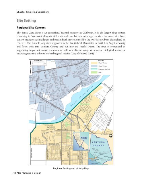
Chapter 1: Existing Conditions Site Setting Regional Site Context The Santa Clara River is an exceptional natural resource in California. It is the largest river system remaining in Southern California with a natural river bottom. Although the river has areas with flood control measures such as levees and stream bank protection (SBP), the river has not been channelized by concrete. The 116 mile long river originates in the San Gabriel Mountains in north Los Angeles County and flows west into Ventura County and out into the Pacific Ocean. The river is recognized as supporting important scenic resources as well as a diverse range of sensitive biological resources, including sensitive habitats and endangered species (City of Oxnard 2004). 4 | Alta Planning + Design Regional Setting and Vicinity Map
Santa Clara River Trail Plan Existing Physical Setting The project site extends for 4.87 miles along the south bank of the Santa Clara River and includes a southern spur connection south to W. Gonzales Road for a bikeway connection to the Pacific Ocean. For most of this distance, the project limits are generally confined to the top of existing flood control structures (SBP areas and levees). These flood control structures vary in height from approximately 10-15 feet above the bed of the Santa Clara River in the western third of the project to 15-20 feet above the bed in the majority of the eastern segment between Highway 101 and Central Avenue. These levee segments are topped by a flood control access road of generally 25-40 feet in width. This road is paved in some areas and is dirt or gravel in others. However, in the central 2,000 foot segment of the project west of Highway 101, no levee currently exists and the project site encompasses a mix of low upland bank areas and river bed. Resource Areas AESTHETICS The proposed project is adjacent to the Santa Clara River, a recognized valuable scenic resource adjacent to the northern boundary of the City of Oxnard. With a width that generally varies from 1,500 to 2,500 feet in the project vicinity, the riverbed provides a wide open corridor that facilitates sweeping views of the Oxnard Plain, with South Mountain and the Topa Topa Mountains to the east. The river’s wide channel supports large areas of natural undeveloped open space, which contrasts with urban uses in the City of Oxnard to the south and the City of Ventura to the north. Views to the north from the project site are dominated by the riverbed, with low-lying agricultural fields, low-density rural structures, and sand/gravel industrial facilities beyond. The large stands of native trees and shrubs enhance the natural aesthetic qualities of this open space and make the river a recognized regional scenic asset (City of Oxnard 2004). AGRICULTURAL RESOURCES Locations along the project offer panoramic views of the Santa Clara River valley with a backdrop of mountain peaks. The project site is located within the Oxnard Plain, a major agricultural production region known for its prime soils and favorable growing climate. Significant agricultural uses exist along the Santa Clara River in the general project vicinity, with the area producing a significant portion of the State of California’s strawberry crop every year. Other major agriculture products in the region include sugar beets and lima beans. Within the City of Oxnard Planning Area, 22,782 acres of land are under agricultural production. Water for agriculture is drawn largely from the Oxnard Plain Basin aquifer (City of Oxnard 2004). City of Oxnard | 5
- Page 2 and 3: Project Partners City of Oxnard Mat
- Page 5 and 6: Santa Clara River Trail Plan Chapte
- Page 7: Santa Clara River Trail Plan 3. Dev
- Page 11 and 12: Santa Clara River Trail Plan Townse
- Page 13 and 14: Santa Clara River Trail Plan much o
- Page 15 and 16: Santa Clara River Trail Plan N. Vic
- Page 17 and 18: Santa Clara River Trail Plan Segmen
- Page 19 and 20: Santa Clara River Trail Plan A cu
- Page 21 and 22: Santa Clara River Trail Plan LEVEE
- Page 23 and 24: Santa Clara River Trail Plan Exi
- Page 25 and 26: Santa Clara River Trail Plan Segmen
- Page 27 and 28: Santa Clara River Trail Plan Segmen
- Page 29 and 30: Santa Clara River Trail Plan Releva
- Page 31 and 32: Santa Clara River Trail Plan former
- Page 33 and 34: Santa Clara River Trail Plan Vent
- Page 35 and 36: Santa Clara River Trail Plan Constr
- Page 37 and 38: Santa Clara River Trail Plan City o
- Page 39 and 40: Santa Clara River Trail Plan City o
- Page 41 and 42: Santa Clara River Trail Plan Chapte
- Page 43 and 44: Santa Clara River Trail Plan The th
- Page 45 and 46: Santa Clara River Trail Plan Alignm
- Page 47 and 48: Santa Clara River Trail Plan and Vi
- Page 49 and 50: Santa Clara River Trail Plan City o
- Page 51 and 52: Santa Clara River Trail Plan Segmen
- Page 53 and 54: Santa Clara River Trail Plan City o
- Page 55 and 56: Santa Clara River Trail Plan City o
- Page 57: Santa Clara River Trail Plan City o
Chapter 1: Existing Conditions<br />
Site Setting<br />
Regional Site Context<br />
The <strong>Santa</strong> <strong>Clara</strong> <strong>River</strong> is an exceptional natural resource in California. It is the largest river system<br />
remaining in Southern California with a natural river bottom. Although the river has areas with flood<br />
control measures such as levees and stream bank protection (SBP), the river has not been channelized by<br />
concrete. The 116 mile long river originates in the San Gabriel Mountains in north Los Angeles County<br />
and flows west into Ventura County and out into the Pacific Ocean. The river is recognized as<br />
supporting important scenic resources as well as a diverse range of sensitive biological resources,<br />
including sensitive habitats and endangered species (City of Oxnard 2004).<br />
4 | Alta <strong>Plan</strong>ning + Design<br />
Regional Setting and Vicinity Map


