Draft - Marine Corps Air Station Miramar
Draft - Marine Corps Air Station Miramar
Draft - Marine Corps Air Station Miramar

You also want an ePaper? Increase the reach of your titles
YUMPU automatically turns print PDFs into web optimized ePapers that Google loves.
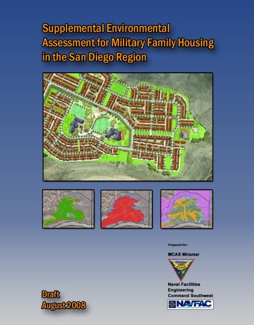
DRAFT<br />
SUPPLEMENTAL ENVIRONMENTAL<br />
ASSESSMENT FOR<br />
MILITARY FAMILY HOUSING<br />
MARINE CORPS AIR STATION MIRAMAR<br />
SAN DIEGO COUNTY<br />
SAN DIEGO, CALIFORNIA<br />
PREPARED FOR:<br />
MARINE CORPS AIR STATION MIRAMAR<br />
AND NAVAL FACILITIES ENGINEERING<br />
COMMAND, SOUTHWEST<br />
AUGUST 13, 2008
D R A F T<br />
SUPPLEMENTAL ENVIRONMENTAL<br />
ASSESSMENT FOR<br />
MILITARY FAMILY HOUSING,<br />
MARINE CORPS AIR STATION<br />
MIRAMAR, SAN DIEGO COUNTY,<br />
SAN DIEGO, CALIFORNIA<br />
Prepared for:<br />
MCAS <strong>Miramar</strong> and<br />
Naval Facilities Engineering Command, Southwest<br />
1220 Pacific Highway<br />
San Diego, CA 92132-5190<br />
Contract No. N68711-04-D-3032<br />
August 13, 2008
Supplemental Environmental Assessment for<br />
Military Family Housing, <strong>Marine</strong> <strong>Corps</strong> <strong>Air</strong> <strong>Station</strong> <strong>Miramar</strong>,<br />
San Diego County, San Diego, California<br />
Lead Agency:<br />
United States <strong>Marine</strong> <strong>Corps</strong><br />
Title of the Proposed Action: Military Family Housing (MFH), <strong>Marine</strong> <strong>Corps</strong> <strong>Air</strong> <strong>Station</strong><br />
(MCAS) <strong>Miramar</strong>, San Diego County, San Diego, California<br />
Affected Region:<br />
Designation:<br />
MCAS <strong>Miramar</strong><br />
Supplemental Environmental Assessment (SEA)<br />
Abstract<br />
This SEA analyzes the potential environmental impacts associated with revisions to the MFH<br />
project description and boundaries previously analyzed in the 2004 Final Environmental Impact<br />
Statement for MFH in the San Diego Region. The SEA analyzes environmental impacts for the<br />
Preferred Alternative including biological resources, cultural resources and schools. No significant<br />
environmental impacts have been identified for the Preferred Alternative. This SEA has been<br />
prepared in accordance with the National Environmental Policy Act (NEPA) of 1969, as amended<br />
(42 U.S. Code [USC] § 4231 et seq.); the Council on Environmental Quality (CEQ) Regulations for<br />
Implementing the Procedural Provisions of NEPA (Title 40 Code of Federal Regulations [CFR] §<br />
1500-1508); and the <strong>Marine</strong> <strong>Corps</strong> Environmental Compliance and Protection Manual (<strong>Marine</strong><br />
<strong>Corps</strong> Order [MCO] P5090.2A). The NEPA process ensures that environmental impacts of<br />
proposed major Federal actions are considered in the decision-making process.<br />
Point of Contact:<br />
Contracting Officer’s<br />
Technical Representative:<br />
Mr. William Moog<br />
Environmental Management Officer<br />
MCAS <strong>Miramar</strong><br />
P.O. Box 452001 Building 6317<br />
San Diego, CA 92145-2001<br />
Phone: (858)577-1108, Fax: (858) 577-4200<br />
Ms. Adrianne Saboya<br />
Environmental Planner<br />
Naval Facilities Engineering Command, Southwest<br />
1220 Pacific Highway<br />
San Diego, CA 92132-5182<br />
Phone: (619) 532-4742 Fax: (619) 532-4160<br />
i
EXECUTIVE SUMMARY<br />
In August 2004, the Department of the Navy (DoN) signed the Record of Decision (ROD)<br />
documenting selection of the Preferred Alternative, Site 8A from the Final Environmental Impact<br />
Statement (FEIS) for Military Family Housing (MFH) in the San Diego Region, ( DoN 2004). The<br />
FEIS proposed action would have provided up to 1,600 units of MFH at <strong>Marine</strong> <strong>Corps</strong> <strong>Air</strong> <strong>Station</strong><br />
(MCAS) <strong>Miramar</strong> (Figure 1) in San Diego County. This Supplemental Environmental Assessment<br />
(SEA) has been prepared by the United States Department of the Navy to document changes in the<br />
FEIS Site 8A project description and in the location and size of the Site 8A limits of construction<br />
(LOC).<br />
This SEA has been prepared in accordance with the National Policy Act (NEPA) of 1969, as<br />
amended (42 U.S. Code [USC] § 4231 et seq.); the Council on Environmental Quality (CEQ)<br />
Regulations for Implementing the Procedural Provisions of NEPA (Title 40 Code of Federal<br />
Regulations [CFR] § 1500-1508); and the <strong>Marine</strong> <strong>Corps</strong> Environmental Compliance and Protection<br />
Manual, Chapter 12 (<strong>Marine</strong> <strong>Corps</strong> Order [MCO] P5090.2A) which establishes procedures for<br />
implementing NEPA. As required by CEQ 1502.9(c), the decision to prepare this supplemental<br />
analysis was based on changes to the Preferred Alternative evaluated in the previous FEIS.<br />
PROPOSED ACTION<br />
The existing regional MFH deficit is 2,870 units. The proposed Project (SEA Site 8A) is designed<br />
to reduce this deficit by providing suitable, affordable housing units for enlisted military personnel<br />
and their families in close proximity to assigned duty <strong>Station</strong>s. The Project proposes to develop<br />
1,400 MFH units on approximately 356 acres at MCAS <strong>Miramar</strong> (Figure 1) in San Diego County.<br />
The Project includes 482 buildings comprised of a mix of one, two and three story townhouse style<br />
duplexes, tri-plexes, four-plexes, five-plexes and six-plexes. The proposed Project includes one<br />
13.3 acre site reserved for siting two elementary schools, and an approximately 2 mile long<br />
extension of Santo Road as the primary access road to State Route 52 (SR-52). Existing unpaved<br />
roads in East <strong>Miramar</strong> will provide secondary emergency access.<br />
After the ROD was signed, a Geographic Information Systems (GIS) mapping error was discovered<br />
that affected the location of the Project boundary. The DoN corrected this error and re-analyzed<br />
resources within the Project LOC. The DoN revised the previously analyzed FEIS footprint from<br />
294 acres to 356 acres. The increase in the FEIS Site 8A acreage was the result of refining the<br />
community plan and incorporating several storm water retention basins in accordance with National<br />
Pollution Discharge Elimination System (NPDES) regulations.<br />
Additional expansion of the Site 8A LOC was required to realign the access road to avoid non-<br />
DoN property. This re-alignment resulted in the inclusion of a previously avoided archeological site<br />
within the LOC and direct impacts to San Diego fairy shrimp found to be present in road<br />
rut/puddles (RECON 2007).<br />
iii
PROJECT ALTERNATIVES<br />
The CEQ NEPA implementation regulations establish a number of policies for federal agencies,<br />
including “using the NEPA process to identify and assess the reasonable alternatives to proposed<br />
actions that will avoid or minimize adverse effects of these actions on the quality of the human<br />
environment” (40 CFR 1500.2[e]). The alternatives considered in the FEIS included Site 2, Site 3,<br />
Site 8B and the No Action Alternative. These alternatives were previously evaluated in the FEIS<br />
and will not be analyzed in the SEA. The SEA evaluates environmental impacts to Site 8A as<br />
modified from the FEIS analysis.<br />
CEQ regulations, NEPA, and DoN procedures for implementing NEPA specify that an<br />
Environmental Assessment (EA) should only address those resource areas potentially subject to<br />
impacts. In addition, the level of analysis should be commensurate with the anticipated level of<br />
environmental impact. The 2004 FEIS analysis of <strong>Air</strong> Quality, Land Use, Socio-economics,<br />
Utilities, Public Services, Soils and Geology, Water Resources, Hazardous Wastes/Substances and<br />
Materials, Noise, Traffic, Public Safety and Visual Resources do not change as a result of the<br />
Preferred Alternative (SEA Site 8A) and are therefore eliminated from further analysis. This SEA<br />
evaluates changes to the FEIS Site 8A Biological Resources (Section 3.1), Cultural Resources<br />
(Section 3.2) and Schools (Section 3.3). Analysis of these changes reveals that there will be no<br />
significant impacts to Biological Resources, Cultural Resources or Schools. The environmental<br />
consequences associated with the Preferred Alternative are presented in Chapter 3.<br />
ENVIRONMENTAL CONSEQUENCES<br />
Due to the proposed changes in the Site 8A LOC, this SEA evaluates impacts to the Del Mar<br />
manzanita, habitat supporting the San Diego fairy shrimp, and archeological resources. Del Mar<br />
manzanita were discovered within the FEIS LOC prior to the signature of the ROD, but at the time,<br />
it was assumed that impacts to this resource could be avoided. The need to document this resource<br />
resulted from new survey information obtained following the Cedar Fire (a region-wide brushfire<br />
that burned a large percentage of MCAS <strong>Miramar</strong> property) and the need to correct the FEIS<br />
mapping error affecting the Preferred Alternative boundary. Because of improved visibility of the<br />
FEIS Site 8A area after the Cedar Fire, the State Historic Preservation Office (SHPO) required resurvey<br />
of some areas within the Site 8A LOC. The DoN initiated surveys under two separate<br />
contracts to document biological and archaeological resources within the revised Project LOC that<br />
were not addressed by the FEIS. In addition, the DoN conducted in-house surveys of 27.3 acres to<br />
address archaeological data gaps not covered in the FEIS or by existing archaeological surveys.<br />
This SEA also documents a reduction in the number of units and a change in the unit mix occurring<br />
after the ROD was signed. In January 2005, the DoN eliminated the two-bedroom units and<br />
increased the number of three and four bedroom units. This change to the unit mix replaced<br />
apartment style buildings with two-story townhouse style units, which are more desirable for<br />
families. In January 2008, DoN reduced the FEIS Site 8A Project from 1,600 units to 1,400 units to<br />
decrease the site density and improve quality of life. This resulted in a decrease in the number of<br />
three bedroom units and an increase in the number of four bedroom units compared to the FEIS unit<br />
iv
mix. Lastly, this SEA evaluates potential impacts on San Diego Unified School District (SDUSD)<br />
primary and secondary schools resulting from the decrease in the number of housing units and<br />
changes to the unit mix.<br />
v
TABLE OF CONTENTS<br />
1<br />
EXECUTIVE SUMMARY ............................................................................................................................. iii<br />
2<br />
3<br />
4<br />
5<br />
6<br />
7<br />
8<br />
9<br />
10<br />
11<br />
12<br />
13<br />
Chapter 1 Purpose and Need for the Proposed Action ...............................................................1-1<br />
1.1 Introduction........................................................................................................................ 1-1<br />
1.2 Purpose and Need for the Proposed Action ....................................................................... 1-1<br />
1.3 Location ............................................................................................................................. 1-1<br />
1.4 Background........................................................................................................................ 1-4<br />
1.5 Scope of SEA Environmental Review ............................................................................... 1-5<br />
1.6 Decisions Needed .............................................................................................................. 1-7<br />
1.7 Regulatory Setting ............................................................................................................. 1-7<br />
Chapter 2 Proposed Action and Alternatives ...............................................................................2-1<br />
2.1 Description of Proposed Action......................................................................................... 2-1<br />
2.2 Alternatives Considered and Eliminated from Further Analysis ....................................... 2-8<br />
2.3 Alternative Carried Forward for Detailed Analysis ........................................................... 2-9<br />
14<br />
15<br />
16<br />
17<br />
18<br />
19<br />
20<br />
Chapter 3<br />
Chapter 4<br />
Existing Environment and Environmental Consequences and Mitigation Measures3-1<br />
3.1 Biological Resources ......................................................................................................... 3-1<br />
3.2 Cultural Resources............................................................................................................3-13<br />
3.3 Schools..............................................................................................................................3-19<br />
Cumulative Effects.........................................................................................................4-1<br />
4.1 Related Projects ................................................................................................................. 4-1<br />
4.2 Environmental Analysis of Related Projects...................................................................... 4-9<br />
21<br />
22<br />
23<br />
24<br />
25<br />
26<br />
27<br />
28<br />
29<br />
30<br />
31<br />
32<br />
Chapter 5 Other NEPA Considerations .........................................................................................5-1<br />
5.1 Possible Conflicts between the Proposed Action and the Objectives of Federal, State and<br />
Local Land Use Plans, Policies and Controls .................................................................... 5-1<br />
5.2 Energy Requirements and Conservation Potential of Alternatives Including the Proposed<br />
Action and All Mitigation Measures Being Considered .................................................... 5-1<br />
5.3 Irreversible or Irretrievable Commitments of Resources that Would be Involved if the<br />
Proposed Action is Implemented ....................................................................................... 5-1<br />
5.4 The Relationship between Local Short-Term Use of the Environment and Maintenance and<br />
Enhancement of Long-Term Productivity ......................................................................... 5-2<br />
5.5 Means to Mitigate and/or Monitor Adverse Environmental Impacts................................. 5-2<br />
5.6 Any Probable and Unavoidably Adverse Environmental Effects Should the Proposal be<br />
Implemented ...................................................................................................................... 5-2<br />
33<br />
Chapter 6<br />
Persons and Agencies Contacted................................................................................6-1<br />
34<br />
Chapter 7<br />
References......................................................................................................................7-1<br />
35<br />
Chapter 8<br />
List of Preparers.............................................................................................................8-1<br />
vi
List of Tables, Figures and Appendices<br />
Tables<br />
Table ES-1<br />
Table 1.4-2<br />
Table 1.5-1<br />
Table 2.3-1<br />
Table 3.1-1<br />
Table 3.1-2<br />
Table 3.1-3<br />
Table 3.2-1<br />
Table 3.3-1<br />
Table 3.3-2<br />
Table 3.3-3<br />
Table 3.3-4<br />
Table 3.3-5<br />
Table 3.3-6<br />
Table 3.3-7<br />
Figures<br />
Figure 1<br />
Figure 2<br />
Figure 3<br />
Figure 4<br />
Figure 5A<br />
Figure 5B<br />
Figure 6<br />
Figure 7<br />
Figure 8<br />
Summary of Potential Environmental Consequences by Resource<br />
Site Plan Changes Since the FEIS<br />
Geographic Extent of Potential Impacts and Mitigations<br />
Summary of Potential Environmental Consequences by Resource<br />
FEIS and SEA Vegetation Impact Comparison<br />
FEIS and SEA Impact Comparison of Wetlands, OWUS<br />
Direct Impacts to Regionally and Locally Declining Vegetation and Habitat Types and Associated<br />
Habitat Compensation (in Acres and Hectares) for SEA Site 8A<br />
Summary: Cultural Resources Located within LOC for the Proposed Action<br />
Site Plan Changes Since the FEIS<br />
Student Generation Rates (1) for MFH Sites<br />
Existing Capacity of Area Schools<br />
Projected Capacity of Area Schools<br />
Site 8A Projected Student Enrollment<br />
SEA Site 8A Student Projected Increase<br />
Capacity of Area Middle and High Schools<br />
MCAS <strong>Miramar</strong> Vicinity Map<br />
FEIS and SEA Site 8A Project Comparison<br />
SEA Site 8A Project Description<br />
SEA Site 8A Preliminary Site Plan<br />
SEA Site 8A Biological Resources<br />
SEA Site 8A California Gnatcatcher Habitat<br />
SEA Site 8A Waters of the U.S.<br />
SEA Site 8A Cultural Resource Survey Areas<br />
Past, Present and Reasonably Foreseeable Actions<br />
Appendices<br />
Appendix A<br />
Appendix B<br />
Appendix C<br />
Appendix D<br />
USFWS Biological Opinion Surveys and Consultation<br />
Clean Water Act Consultation<br />
Archaeological Survey and Consultation<br />
SDUSD Provided Data<br />
vii
Acronyms<br />
ACHP<br />
Advisory Council on Historic Preservation<br />
ARAR<br />
Applicable or Relevant and Appropriate Requirement<br />
ASM<br />
ASM Affiliates, Inc.<br />
BAH<br />
Basic Allowances for Housing<br />
CAGN<br />
California gnatcatcher<br />
CALTRANS California Department of Transportation<br />
CEQ<br />
Council on Environmental Quality<br />
CERCLA Comprehensive Environmental Response Compensation & Liability Act<br />
CFR<br />
Code of Federal Regulation<br />
CSS<br />
Coastal sage scrub<br />
DMM<br />
Del Mar manzanita<br />
DoN<br />
Department of the Navy<br />
EA<br />
Environmental Assessment<br />
EE/CA<br />
Engineering Evaluation/Cost Analysis<br />
EMD<br />
Environmental Management Department<br />
EO<br />
Executive Order<br />
FEIS<br />
Final Environmental Impact Statement<br />
FONSI<br />
Finding of No Significant Impact<br />
GIS<br />
Geospatial Information System<br />
HQMC<br />
Headquarters <strong>Marine</strong> <strong>Corps</strong><br />
INRMP<br />
Integrated Natural Resources Management Plan<br />
LOC<br />
Limits of Construction<br />
MBTA<br />
Migratory Bird Treaty Act<br />
MCAS<br />
<strong>Marine</strong> <strong>Corps</strong> <strong>Air</strong> <strong>Station</strong><br />
MCO<br />
<strong>Marine</strong> <strong>Corps</strong> Order<br />
MEC<br />
Munitions and Explosives of Concern<br />
MFH<br />
Military Family Housing<br />
NAVFAC Naval Facilities Engineering Command<br />
NCCP<br />
Natural Community Conservation Plan<br />
NEPA<br />
National Environmental Policy Act<br />
NHPA National Historic Preservation Act of 1996<br />
NPDES<br />
National Pollution Discharge Elimination System<br />
NRHP<br />
National Register of Historic Places<br />
OWUS<br />
Other Waters of the United States<br />
PPV<br />
Public Private Venture<br />
PPV LLC Public-Private Venture Limited Liability Company<br />
ROD<br />
Record of Decision<br />
SDFS<br />
San Diego fairy shrimp<br />
SDG&E<br />
San Diego Gas & Electric<br />
SDUSD<br />
San Diego Unified School District<br />
SEA<br />
Supplemental Environmental Assessment<br />
SEIS<br />
Supplemental Environmental Impact Statement<br />
SF<br />
Square Feet<br />
SHPO<br />
State Historic Preservation Office<br />
SR<br />
State Route<br />
STP<br />
Shovel Test Pit<br />
SWPPP<br />
Storm Water Pollution Prevention Plan<br />
USFWS<br />
United States Fish and Wildlife Service<br />
viii
ix<br />
Acronyms
CHAPTERONE<br />
Purpose and Need for Proposed Action<br />
CHAPTER 1 PURPOSE AND NEED FOR THE PROPOSED ACTION<br />
1.1 INTRODUCTION<br />
The Final Environmental Impact Statement (FEIS) prepared for Military Family Housing (MFH) in the San<br />
Diego Region analyzed development of Site 2, Site 3, Site 8A and Site 8B for the proposed MFH<br />
development at <strong>Marine</strong> <strong>Corps</strong> <strong>Air</strong> <strong>Station</strong> (MCAS) <strong>Miramar</strong> in San Diego, California. In August 2004, the<br />
Department of the Navy’s (DoN) Record of Decision (ROD) documented Site 8A as the Preferred<br />
Alternative for the proposed development of up to 1,600 MFH units at MCAS <strong>Miramar</strong>. Since the ROD<br />
was signed in 2004, changes to the Preferred Alternative (Site 8A) and associated environmental<br />
consequences substantiated preparation of the Supplemental Environmental Assessment (SEA). This SEA<br />
documents changes to the Preferred Alternative evaluated in the FEIS for MFH in the San Diego Region,<br />
(DoN 2004). The revised Preferred Alternative (Site 8A) is the proposed action analyzed in this SEA and is<br />
referred to as the proposed Project throughout the SEA.<br />
1.2 PURPOSE AND NEED FOR THE PROPOSED ACTION<br />
The purpose and need for the proposed Project is to reduce the regional housing deficit by providing<br />
suitable, affordable housing for enlisted military personnel and their families in close proximity to assigned<br />
duty <strong>Station</strong>s. The Housing Requirements Market Analysis published in 2002 (Science Applications<br />
International Corporation) identified an existing housing deficit of 2,356 units and a projected shortfall of<br />
2,870 units for 2007.<br />
The shortage of MFH and high rental rates in San Diego County adversely affect military families, primarily<br />
junior and mid-level enlisted military personnel, E1-E6. A substantial number of military families pay out of<br />
pocket costs to bridge the increasing gap between market rents and Basic Allowances for Housing (BAH).<br />
To find suitable and affordable housing, some military families live significant distances from assigned duty<br />
stations. Families that do not live in close proximity to assigned duty stations are impacted by lengthy<br />
commutes and have a reduced level of access to associated military community resources and social<br />
networks that are critical for supporting quality of life. The provision of affordable, suitable housing that is<br />
centrally located is critical for morale, retention and combat readiness of Navy and <strong>Marine</strong> service members.<br />
1.3 LOCATION<br />
MCAS <strong>Miramar</strong> is located 13 miles north of downtown San Diego and 4 miles east of the Pacific Ocean.<br />
State Route (SR) 52 and Interstate 805 (I-805) form the <strong>Station</strong>’s southern and western boundaries. MCAS<br />
<strong>Miramar</strong> is divided by Interstate 15 (I-15) and encompasses over 23,000 acres. The area west of I-15, or<br />
West <strong>Miramar</strong>, supports the industrial and aviation complex with ancillary support of commercial,<br />
administrative and existing MFH. The area east of I-15, referred to as East <strong>Miramar</strong>, contains existing<br />
training areas, rifle/pistol ranges and ordnance storage and the proposed Project site (Figure 1).<br />
1-1
<strong>Miramar</strong><br />
Ranch North<br />
Mira Mesa<br />
§¨¦ 15<br />
Scripps<br />
Ranch<br />
§¨¦ 805 §¨¦ 5 §¨¦ 15<br />
East<br />
Elliot<br />
University<br />
City<br />
Clairemont<br />
Kearny<br />
Mesa<br />
tu 56 tu 52 tu 125<br />
Tierrasanta<br />
Mission<br />
Trails<br />
Regional<br />
Park<br />
Santee<br />
OVERVIEW MAP<br />
MCAS <strong>Miramar</strong><br />
tu 163<br />
§¨¦ 8<br />
LEGEND<br />
SOURCES:<br />
USGS (7.5 quads: Del Mar, Poway, La Jolla, La Mesa);<br />
SANDAG (county 2000, freeways 2005);<br />
MCAS <strong>Miramar</strong> (installation boundary);<br />
NAVFAC (limits of construction).<br />
1 100 200Feet0<br />
0 1 2 Miles<br />
SCALE: 1" = 2 Miles (1:126,720)<br />
tu 94<br />
MCAS MIRAMAR VICINITY MAP<br />
MILITARY FAMILY HOUSING<br />
CREATED BY: JN DATE: 01-21-08<br />
PM: EN PROJ. NO: 27696000.00001<br />
MCAS <strong>Miramar</strong> Boundary<br />
Proposed MFH<br />
Limits of Construction<br />
FIG. NO:<br />
1
!<br />
SEA<br />
LIMITS OF CONSTRUCTION<br />
! ! ! ! ! ! ! ! ! ! ! ! ! !<br />
! ! ! ! ! ! !<br />
!! ! ! ! !<br />
! ! ! ! ! ! ! ! ! ! ! !<br />
CERCLA<br />
MUNITIONS RESPONSE<br />
! !<br />
! ! ! ! ! ! !<br />
! ! !! ! ! ! ! ! ! !!<br />
! ! !<br />
! ! !! ! ! ! ! ! ! ! ! ! !! ! ! ! ! !<br />
!<br />
! ! !! ! ! ! ! ! !! ! ! ! ! ! ! ! ! ! ! ! ! ! ! ! ! ! ! ! ! ! ! ! !! ! ! ! ! ! ! ! ! ! ! ! ! ! ! ! ! ! ! ! ! ! ! ! ! ! ! ! ! ! ! ! ! ! ! ! !<br />
! ! ! ! !<br />
! ! ! ! !<br />
! ! ! ! ! !<br />
! ! !<br />
! ! ! ! ! ! !<br />
! ! ! !! !<br />
! ! !<br />
! ! ! ! ! ! ! ! ! ! ! ! ! ! ! !<br />
!<br />
! ! ! ! ! !! ! ! ! ! ! ! ! !!<br />
!<br />
! ! ! ! !<br />
! ! ! ! ! ! ! !<br />
Parcel Owner:<br />
San Diego Unified<br />
School District<br />
! ! ! ! ! ! ! ! ! ! ! ! ! ! ! ! ! ! ! ! ! ! ! ! ! !<br />
Parcel<br />
Owner:<br />
State of<br />
California<br />
tu 52<br />
! ! ! ! ! ! ! ! !<br />
! ! !! ! ! ! ! ! ! ! ! ! !<br />
! ! ! !<br />
! !! ! !<br />
! ! ! ! ! ! ! !<br />
! ! !<br />
! ! ! ! ! ! ! ! !<br />
! ! !<br />
! ! ! ! !<br />
! ! ! !<br />
! ! ! ! ! ! !!<br />
! !! ! ! ! ! ! ! ! !<br />
! ! !<br />
!<br />
!<br />
!!<br />
! ! ! !!<br />
FEIS<br />
RESOURCE SURVEY BOUNDARY<br />
LIMITS OF CONSTRUCTION<br />
PROJECT DIVISION LINE<br />
! ! ! ! !! ! ! !<br />
! ! !<br />
!!! ! ! ! ! ! ! ! ! ! ! ! !<br />
! ! !!<br />
!<br />
! ! !<br />
! ! !<br />
!<br />
! ! ! !<br />
!<br />
ACCESS<br />
ROAD<br />
! ! ! ! ! ! ! ! ! ! ! !<br />
! ! ! ! ! ! ! ! ! ! ! ! ! ! ! ! ! ! ! ! ! ! ! ! ! ! ! ! !<br />
HOUSING SITE<br />
! ! ! ! ! ! ! ! ! ! !<br />
LIM ITS OF<br />
CONSTRUCTION (LOC)<br />
RESOURCE SURVEY<br />
BOUNDARY OUTSIDE<br />
FEIS LOC<br />
CERCLA MUNITIONS<br />
RESPONSE<br />
1<br />
!! !!<br />
!! ! !!<br />
SOURCES: SEA project features originated by<br />
Clark Realty and provided by NAVFAC<br />
Southwest. FEIS project features provided by<br />
NAVFAC Southwest. March 2004 aerial<br />
provided by MCAS <strong>Miramar</strong>.<br />
! ! ! ! ! ! ! ! ! ! ! ! ! ! ! ! ! ! ! ! ! ! ! ! ! ! ! ! ! ! ! ! ! !<br />
500 1000 0 500 0 1000 1500 1000Feet<br />
2000 Feet<br />
SCALE: 1" = 1,000' (1:12,000)<br />
FEIS SEA Net Change<br />
LOC Site LOC<br />
(P ink Line)<br />
Site: 264 acres 300 acres + 36 acres<br />
Access Road: 34 acres 56 acres + 22 acres<br />
Total: 298 acres 356 acres + 58 acres<br />
FEIS<br />
Resource Survey<br />
Boundary<br />
(Red Line)<br />
Site:<br />
316 acres<br />
Access Road:<br />
21 acres<br />
Total:<br />
337 acres<br />
FEIS Acreages Not Affected by the SEA LOC<br />
SEA LOC Not Evaluated in FEIS<br />
Housing Site - 21 Acres Housing Site - 56 Acres<br />
Access Road - 18 Acres<br />
Access Ro ad - 43 Acres<br />
Total - 39 Acres<br />
To tal - 99 Acres<br />
FEIS AND SEA SITE 8A PROJECT COMPARISON<br />
MCAS MIRAMAR<br />
MILITARY FAMILY HOUSING<br />
CREATED BY: JN DATE: 03-25-08<br />
PM: EH PROJ. NO: 27696000.00001<br />
FIG. NO:<br />
2<br />
1. The exact location of the munitions response is contingent on the results of the CERLCA process.
CHAPTERONE<br />
Purpose and Need for Proposed Action<br />
1.4 BACKGROUND<br />
The June 2004 FEIS evaluated the DoN proposal to construct up to 1,600 MFH units in response to the<br />
growing need for suitable and affordable housing for enlisted personnel (E1-E6) and their families in the<br />
San Diego region. The FEIS analyzed four action alternatives, Site 2, Site 3, and Site 8A (the Preferred<br />
Alternative), Site 8B, and the No Action Alternative. As documented in the August 2004 ROD, Site 8A was<br />
selected as the FEIS Preferred Alternative. The FEIS Preferred Alternative site plan accommodated<br />
approximately 282 buildings comprised of duplexes, four-plexes, six-plexes and eight-plexes configured in<br />
townhouse and apartment style buildings. This site plan provided 400 two bedroom units, 896 three<br />
bedroom units, and 304 four bedroom units. FEIS Site 8A Limits of Construction (LOC) and FEIS Site 8A<br />
resource survey boundaries are depicted in Figure 2.<br />
1.4.1 Revisions to the Limits of Construction<br />
Changes to the FEIS Site 8A Housing LOC resulted from refining the community plan and from the<br />
addition of several storm water retention basins in accordance with National Pollution Discharge<br />
Elimination System (NPDES) regulations. Additional expansion of the Site 8A LOC was required to realign<br />
the access road to avoid non-DoN property. As part of the re-alignment, the access road LOC was revised to<br />
incorporate safe roadway design geometries and avoid two existing utility easements. In July 2006, the DoN<br />
finalized the Housing LOC.<br />
Due to improved visibility of the MFH Project area after the Cedar Fire in October 2003, the State Historic<br />
Preservation Office (SHPO) required re-survey of some areas within the FEIS Site 8A area. Surveys of the<br />
2003 Cedar Fire areas were conducted between January 2, 2004 and April 30, 2004. This effort included<br />
site testing on three previously recorded sites. “The Archaeological Survey of MFH Site 8 and the Testing of<br />
Three Sites, San Diego California” was initiated to perform site survey and testing in accordance with<br />
Section 106 of the National Historic Preservation Act of 1966 (NHPA). The access road re-alignment<br />
required to avoid non-DoN property resulted in the inclusion of an archeological site within the LOC.<br />
Subsequent surveys were conducted within the Project LOC by DoN Archaeologists (Refer to Figure 7 and<br />
Appendix C).<br />
The 2004 FEIS and subsequent ROD assumed that impacts to the Del Mar manzanita (DMM) and San<br />
Diego fairy shrimp (SDFS) would be avoided. After the Site 8A mapping error in the FEIS was discovered,<br />
the site was resurveyed for the DMM. These post-Cedar Fire surveys revealed that impacts to the DMM<br />
were unavoidable. The re-alignment of the Project boundary to correct the FEIS mapping error resulted in<br />
direct impacts to the SDFS found to be present in road rut/puddles (RECON 2007). The “Biological<br />
Assessment for the MFH Project (Site 8) on MCAS <strong>Miramar</strong>” was initiated to describe effects on listed and<br />
proposed species that occur or have the potential to occur within the Project LOC. During preparation of the<br />
Biological Assessment, a rounding error was discovered in the vernal pool acreage documented in the 2004<br />
FEIS. Although the number of vernal pools in the proposed Project has not changed since the FEIS, the<br />
proposed Project increases the vernal pool impact from 0.01 (FEIS) to 0.02 acres.<br />
1-4
CHAPTERONE<br />
Purpose and Need for Proposed Action<br />
Prior to August 2004, FEIS Site 8A was managed as part of an operational range complex reserved for<br />
ground training activities. In order to implement a change in land use from an operational range complex to<br />
a residential neighborhood, the Proposed Munitions Response Limits illustrated in Figure 3 were defined as<br />
the area that would be evaluated in the site’s Comprehensive Environmental Response Compensation &<br />
Liability Act (CERCLA) documentation. The CERCLA response will be used to facilitate regulatory<br />
closure of the site for the planned construction of MFH units and other land uses incompatible with<br />
operational range activities. In support of the CERCLA response, an Engineering Evaluation/Cost Analysis<br />
(EE/CA) will be prepared by the DoN. The EE/CA evaluates the extent and impact of Munitions and<br />
Explosives of Concern (MEC) and presents removal action alternatives to reduce the risks and hazards<br />
associated with MEC. This effort includes the preparation of recommendations for implementing response<br />
actions inside and outside the LOC.<br />
1.4.2 Revisions to Unit Mix/Housing Type<br />
On January 4, 2005, the DoN issued a revision to the FEIS Site 8A unit mix to support MFH demand and<br />
improve neighborhood quality of life. The changes eliminated the two bedroom units and increased the<br />
number of three and four bedroom units. Three and four bedroom units were desirable because they<br />
supported the demand for housing, while providing typical market rate amenities such as home offices, extra<br />
living areas and exercise/hobby rooms. Another key change in the 2005 site plan revision was the<br />
replacement of apartment style buildings with two-story townhouse style units, which are more desirable for<br />
families. In January 2008, the DoN reduced the Project from 1,600 units to 1,400 units and revised the unit<br />
mix to support an increased quality of life through lower site density. This change resulted in a decrease in<br />
the number of three bedroom units and an increase in four bedroom units compared to the previous FEIS<br />
analysis. Refer to Table 1.4-2 for a comparison of proposed FEIS and SEA site plans.<br />
Table 1.4-2<br />
Site Plan Changes Since the FEIS<br />
2004 FEIS Site Plan 2008 SEA Site Plan Change in Units<br />
Number of Units 1,600 1,400 -200<br />
2-Bedroom Units 400 0 -400<br />
3-Bedroom Units 896 840 -56<br />
4-Bedroom Units 304 560 +256<br />
1.5 SCOPE OF SEA ENVIRONMENTAL REVIEW<br />
The decision to prepare a SEA was based on 40 CFR 1502.9(c) guidance, which requires that supplements<br />
to FEISs be prepared if:<br />
(i) The agency makes substantial changes in the Proposed Action that are relevant to environmental<br />
concerns; or<br />
(ii) There are significant new circumstances or information relevant to environmental concerns and<br />
bearing on the Proposed Action or its impacts.<br />
1-5
CHAPTERONE<br />
Purpose and Need for Proposed Action<br />
This SEA is a focused assessment of the changes in the specific resource areas noted above from the<br />
previously approved FEIS Preferred Alternative. The scope of the SEA analysis was determined through a<br />
three step screening process. The first step identified resources that have not changed since the FEIS. The<br />
second step preliminarily evaluated resources that may be affected by changes to the Preferred Alternative.<br />
The third step identified those resources that require evaluation in the SEA as a result of changes to the<br />
Preferred Alternative.<br />
Changes to the proposed Project would not significantly affect the following resources differently from that<br />
described in the June 2004 FEIS, and are therefore excluded from analysis in the SEA: Land Use, Socioeconomics,<br />
<strong>Air</strong> Quality, Utilities, Public Services, Traffic, Hazardous Wastes/Substances and Materials,<br />
Noise, and Public Safety. Resources that were preliminarily evaluated, then eliminated from detailed<br />
analysis in the SEA included Soils and Geology, Water Resources and Visual Resources.<br />
Soils and Geology: The Preferred Alternative would not result in different impacts than those stated in the<br />
FEIS. Although the Preferred Alternative increases the LOC by 61.7 acres, the impact and mitigation<br />
measures required are the same as those provided in FEIS sections 3.8 and 4.8. The increase of the Project<br />
footprint, distributed across the Project, only causes pro rata growth in previously proposed mitigation<br />
measures that are standard in the construction industry. The change in the LOC represents an incremental<br />
increase to the proposed FEIS mitigation measures which would remain effective; no additional evaluation<br />
of impacts to Soils and Geology is performed in this SEA.<br />
Water Resources: The Preferred Alternative would not result in different impacts than those stated in the<br />
FEIS. Although the Preferred Alternative increases the LOC by 61.7 acres, the impact and mitigation<br />
measures required are similar to those provided in FEIS sections 3.9 and 4.9. The revised site plan in the<br />
SEA also incorporates non-discretionary requirements from NPDES regulations (i.e. storm water retention<br />
basins) that were not part of the FEIS conceptual site plan. The revised Project site plan would result in<br />
identical or reduced impacts to the water resources described in the FEIS. Therefore, no additional<br />
evaluation was required for this resource.<br />
Visual Resources: Implementation of the Preferred Alternative would not increase the visual impacts from<br />
those described in the FEIS. The revised site plan decreases the number of housing units from the 1,600<br />
units proposed in the FEIS to 1,400 units and replaces larger apartment style buildings proposed in the FEIS<br />
with smaller townhouse style buildings with predominantly two, three, and four-plex buildings. A<br />
significant reduction of building sizes, from 282 larger buildings to 482 smaller buildings, would result from<br />
the site plan revision. This change enhances view sheds across the community and provides greater open<br />
space within the community. These changes do not present an additional visual impact from the Key View<br />
and Key Observation Points illustrated in FEIS Figure 4.5-1. Therefore, no additional evaluation was<br />
required for this resource.<br />
The scope of this SEA environmental review focuses on Biological Resources (Section 3.1), Cultural<br />
Resources (Section 3.2) and Schools (Section 3.3). These resources require re-evaluation in the SEA to<br />
document changes to the Preferred Alternative.<br />
1-6
CHAPTERONE<br />
Purpose and Need for Proposed Action<br />
1.6 DECISIONS NEEDED<br />
This SEA is intended to provide sufficient evidence and analysis for determining whether to prepare a<br />
Supplemental Environmental Impact Statement (SEIS) or a Finding of No Significant Impact (FONSI)<br />
based on proposed changes to the FEIS Site 8A Preferred Alternative (DoN 2004). A FONSI would be<br />
prepared if all associated impacts can be mitigated to levels that are less than significant. If impacts cannot<br />
be avoided or reduced to less than significant levels, a SEIS would be prepared.<br />
1.7 REGULATORY SETTING<br />
This SEA has been prepared in accordance with the following statutes and guidelines:<br />
a. National Environmental Policy Act (NEPA) of 1969 (42 U.S.C. §§ 4321-4370d [1994]), which<br />
requires an environmental analysis for Federal actions having the potential to impact the quality of<br />
the natural and human environment;<br />
b. Council on Environmental Quality (CEQ) Regulations for Implementing the Procedural Provisions<br />
of NEPA (Title 40 Code of Federal Regulations [CFR] §§ 1500-1508);<br />
c. DoN Regulations Implementing NEPA (32 CFR Part 775), which provides DoN policy for<br />
implementing the CEQ regulations and NEPA;<br />
d. US <strong>Marine</strong> <strong>Corps</strong> Order (MCO) P5090.2A, Environmental Compliance and Protection Manual<br />
Chapter 12, which establishes procedures for implementing NEPA.<br />
1-7
CHAPTERONE<br />
Purpose and Need for Proposed Action<br />
1-8
CHAPTERTWO<br />
Proposed Action and Alternatives<br />
CHAPTER 2 PROPOSED ACTION AND ALTERNATIVES<br />
2.1 DESCRIPTION OF PROPOSED ACTION<br />
The proposed Project (SEA Site 8A) is a revision to the FEIS Preferred Alternative (FEIS Site 8A). The<br />
proposed Project would develop 1,400 MFH units at MCAS <strong>Miramar</strong>. The primary access road from SR-<br />
52 will be an approximately 2 mile long extension of Santo Road. The proposed Project would begin with<br />
munitions response action in 2009. Mass grading would start in 2010 and building construction would<br />
commence in 2011 with an estimated completion date of 2017. Sections 2.1.1 and 2.1.2 describe elements<br />
of the Preferred Alternative that have changed since the 2004 FEIS and ROD.<br />
2.1.1 Revised Limits of Construction<br />
The revised footprint of approximately 356 acres includes the LOC for the housing development and<br />
access road. As illustrated in Figure 3, the proposed Project LOC includes storm water retention basins<br />
and fire management zones. Retention basins are provided in accordance with NPDES requirements. Fuel<br />
Break Zone 1 (red buffer zone) and Fuel Break Zone 2 (pink buffer zone) extend 100 feet from the<br />
housing perimeter to the outer edge of the LOC. According to the City of San Diego’s Guide to Fire<br />
Safety and Brush Management for Private Property (Revised May 2004) guidance, Fuel Break Zone 1 is<br />
an irrigated zone of 40 feet containing ornamental landscape species, while Fuel Break Zone 2 is a 40 foot<br />
wide non-irrigated buffer containing native vegetation. Beyond Zone 2 is a third zone (20 feet wide)<br />
which includes thinned and pruned native vegetation.<br />
The proposed Project access road LOC realigns the approximately 2-mile Santo Road extension identified<br />
in FEIS Site 8A. The access road LOC contains areas proposed for re-vegetation with native species. The<br />
realignment increases the access road LOC to 56 acres, which is a 22 acre increase from the FEIS Site 8A<br />
alignment.<br />
2.1.2 Revised Unit Mix/Housing Type<br />
As illustrated in Figure 4, the revised 1,400 unit conceptual site development plan currently proposes to<br />
construct up to 482 buildings comprised of a mix of one, two and three-story townhouse style duplexes,<br />
tri-plexes, four-plexes, five-plexes and six-plexes. The associated unit mix includes 560 three bedroom<br />
units and 840 four bedroom units. The final site plan, to be submitted to and filed with the Navy, is<br />
expected to be substantially consistent with the housing types described above. Refer to Table 1.4-2.<br />
2-1
!<br />
! ! ! ! ! ! ! ! ! ! ! ! ! ! ! ! !<br />
! ! ! ! ! ! ! ! ! ! ! ! ! !<br />
! ! ! ! ! ! !<br />
!! ! ! ! !<br />
! ! ! ! ! ! ! ! ! ! ! !<br />
! ! !! ! ! ! ! ! !! ! ! ! ! ! ! ! ! ! ! ! ! ! ! ! ! ! ! ! ! ! ! ! !! ! ! ! ! ! ! ! ! ! ! ! ! ! ! ! ! ! ! ! ! ! ! ! ! ! ! ! ! ! ! ! ! ! ! ! !<br />
! !<br />
! ! ! ! ! ! !<br />
! ! ! ! ! !<br />
! ! ! ! ! ! !<br />
! ! !! ! !<br />
! ! !<br />
! ! ! ! ! ! !<br />
! ! ! !! !<br />
! ! !<br />
! ! ! ! ! ! ! ! ! ! ! ! ! ! ! !<br />
!<br />
!<br />
! ! ! ! ! !! ! ! ! ! ! ! ! !!<br />
! ! ! ! !<br />
! !! ! ! ! ! !<br />
Parcel Owner:<br />
San Diego Unified<br />
School District<br />
! ! ! ! ! ! ! ! ! ! ! ! ! ! ! ! ! ! ! ! ! ! ! ! ! !<br />
Parcel<br />
Owner:<br />
State of<br />
California<br />
tu 52<br />
! ! ! ! ! ! ! ! !<br />
1. The exact location of the munitions response is contingent on the results of the CERLCA process.<br />
! ! !! ! ! ! ! ! ! !! ! !<br />
! ! ! !<br />
! !! ! !<br />
! ! ! ! ! ! ! !<br />
! ! !<br />
! ! ! ! ! ! ! ! !<br />
! !!<br />
! ! ! ! !<br />
! ! ! !<br />
! ! ! ! !<br />
! !!<br />
! !! ! ! ! ! ! ! ! !<br />
! ! !<br />
!<br />
!<br />
!!<br />
! ! ! !!<br />
PROJECT DIVISION LINE<br />
! ! ! ! !! ! ! !<br />
! ! !<br />
!!! ! ! ! ! ! ! ! !<br />
! ! !!<br />
! ! ! !<br />
!<br />
! ! !<br />
! ! !<br />
!<br />
! ! ! !<br />
! ! !! ! ! ! ! ! ! !!<br />
!<br />
ACCESS<br />
ROAD<br />
! ! !<br />
! ! ! ! ! ! ! ! ! ! ! !<br />
! ! ! ! ! ! ! ! ! ! ! ! ! !! ! ! ! ! !<br />
! ! ! ! ! ! ! ! ! ! ! ! ! ! ! ! ! ! ! ! ! ! ! ! ! ! ! ! !<br />
!<br />
HOUSING SITE<br />
!( !( !(<br />
!(<br />
!( !( !(<br />
!( !(<br />
!( !(<br />
!( !(<br />
!( !( !(<br />
!( !(<br />
SOURCES: SEA project features originated by<br />
Clark Realty and provided by NAVFAC<br />
Southwest. FEIS project features provided by<br />
NAVFAC Southwest. March 2004 aerial<br />
provided by MCAS <strong>Miramar</strong>.<br />
500 1000 0 500 0 1000 1500 1000Feet<br />
2000 Feet<br />
SCALE: 1" = 1,000' (1:12,000)<br />
! ! ! ! ! ! ! ! ! ! ! ! ! ! ! ! ! ! ! ! ! ! ! ! ! ! ! !<br />
LEGEND<br />
SEA Proposed Project Limits<br />
!!!<br />
!( !( !( !( !(<br />
!( !( !( !( !(<br />
!( !( !( !( !(<br />
Limits of Construction (LOC)<br />
Site Acreage - 300<br />
Access Road Acreage - 56<br />
CERCLA Munitions Response 1<br />
Native Revegetation Areas<br />
Site Development Plan<br />
Fuelbreak Zone 1<br />
Fuelbreak Zone 2<br />
Detention Basins<br />
Drainage Channel<br />
MCAS <strong>Miramar</strong> Boundary<br />
Note: Maintenance Road Acreages were<br />
calculated outside the Limits of Construction.<br />
SEA SITE 8A PROJECT DESCRIPTION<br />
MCAS MIRAMAR<br />
MILITARY FAMILY HOUSING<br />
CREATED BY: JN DATE: 03-25-08<br />
PM: EH PROJ. NO: 27696000.00001<br />
FIG. NO:<br />
3<br />
! ! ! ! ! ! !
CHAPTERTWO<br />
Proposed Action and Alternatives<br />
2.1.3 Project Features and Mitigation Measures<br />
The following project features are included as part of the proposed Project to mitigate project related<br />
impacts below a significant level. Mitigations described in this section are provided for resources with<br />
increased impacts relative to the previous FEIS analysis.<br />
2.1.3.1 Schools<br />
As illustrated in Figures 3 and 4, the proposed Project includes a 13.3 acre school site reserved for two<br />
elementary schools. The two elementary schools would be built by the San Diego Unified School District<br />
(SDUSD). Refer to Table 2.3.1 for a summary of impacts and mitigations.<br />
2.1.3.2 Biological Resources<br />
A Section 7 Endangered Species Act consultation was conducted to obtain the United States Fish and<br />
Wildlife Service (USFWS) Biological Opinion regarding the effects of the Preferred Alternative on<br />
Federally listed threatened and endangered species. All conservation and mitigation measures provided in<br />
the USFWS Biological Opinion (Appendix A) will be implemented.<br />
Plant and Aquatic Communities<br />
As part of the proposed Project, impact minimization measures for potential impacts to regionally<br />
declining vegetation would be implemented in accordance with the mitigation planning guidance<br />
provided in the Integrated Natural Resources Management Plan (INRMP) (MCAS <strong>Miramar</strong> 2006). This<br />
management plan was developed in cooperation with the resource agencies. Appropriate public comments<br />
were considered in the preparation of this plan. Table 2.3-1 lists the acreages of direct impacts to<br />
regionally and locally declining vegetation and habitat types by the current project, and associated<br />
compensation.<br />
Special Status Species<br />
• California gnatcatcher - Approximately 5.6 acres of historically California gnatcatcher (CAGN)<br />
occupied disturbed coastal sage scrub (CSS) habitat is present within the Access Road LOC. This<br />
area represents a portion of one territory which, prior to the Cedar Fire, supported one pair of<br />
CAGN. Although the site is presently not known to be occupied, this impact represents an<br />
increase over the previous FEIS analysis, which did not identify any potential impact to CAGN.<br />
• Del Mar manzanita - Impact to 30 DMM individuals would occur within the Housing Site LOC.<br />
No impacts were identified in the previous FEIS analysis.<br />
• San Diego fairy shrimp- Impact to 2 SDFS occupied road ruts/man-made puddles would occur<br />
within the Access Road LOC. This impact represents an increase over the previous FEIS analysis,<br />
which did not identify an impact to the species.<br />
Refer to Table 2.3-1 for project features and mitigation measures that minimize project impacts on the<br />
CAGN, DMM, and SDFS.<br />
2-3
CHAPTERTWO<br />
Proposed Action and Alternatives<br />
Species of Regional Special Concern<br />
Implementation of the following project measures would ensure that there would be no significant direct<br />
impacts to any species of regional special concern or birds protected under the Migratory Bird Treaty Act<br />
(MBTA):<br />
• Compensation for the loss of regionally rare vegetation/habitat types described for direct impacts<br />
to these types would also compensate for the loss of habitats for Species of Regional Special<br />
Concern.<br />
• Vegetation clearing activities would be timed to avoid the breeding season of migratory birds to<br />
the maximum extent practicable to avoid damage to active bird nests. If habitat clearing outside<br />
of the breeding season is infeasible, the Public Private Venture (PPV) contractor(s) shall hire a<br />
qualified biologist to conduct a nest survey and avoid the taking of any active migratory bird<br />
nests. For planning purposes, migratory breeding season is February 15 to August 31.<br />
Temporary indirect impacts to Species of Regional Special Concern and birds protected under the<br />
MBTA are incidental to the Project and are not expected to be significant.<br />
Jurisdictional Wetlands and Waters of the United States<br />
A previous assessment of these resources in the 2004 EIS documents that they have low function and<br />
value, limited to flood flows. The ephemeral drainages support a minimal amount of wetlands, i.e.,<br />
freshwater seeps, and these wetlands have a moderate habitat value. Impacts to wetlands and other waters<br />
of the United States (U.S.) would be mitigated through implementation of agency permit conditions<br />
developed during the CWA 404/401 process. Although associated permitting is being prepared as<br />
CERCLA Applicable or Relevant and Appropriate Requirements (ARARs), proposed impact<br />
minimization ratios and acreage for jurisdictional waters and wetlands are shown in Table 2.3-1.<br />
2-4
CHAPTERTWO<br />
Proposed Action and Alternatives<br />
1<br />
2<br />
Table 2.3-1<br />
Summary of Project Features and Impact Minimization Measures by Resource<br />
Resource<br />
Change in<br />
Impacts1 Project Features and Impact Minimization Measure<br />
BIOLOGICAL RESOURCES<br />
Native grassland -1.8 acres Proposed Project reduces impacts below those stated in the 2004 FEIS.<br />
Disturbed native<br />
grassland<br />
- 1.1 acres<br />
Proposed Project reduces impacts below those stated in the 2004 FEIS.<br />
Un-vegetated Waters of<br />
the U.S. (1:1)<br />
+ 2.63 acres Provide a compensation of 3.30 acres, an increase of 2.63 acres over the previous<br />
analysis. Impacts to wetlands and other waters of the US would be mitigated through<br />
implementation of agency permit conditions developed during the CWA 404/401 process.<br />
Compensatory mitigation would include onsite or offsite wetland vegetation creation and<br />
enhancement. CWA permitting is being implemented through the CERCLA process.<br />
Del Mar manzanita + 30<br />
individuals<br />
A Restoration Plan for DMM and its habitat would be prepared by a biologist with<br />
experience and/or knowledge of DMM or chaparral restoration. The Plan would include a<br />
5-year maintenance and monitoring program, measurable restoration success criteria, and<br />
an adaptive management strategy/outline. All restoration planning would be coordinated<br />
with Natural Resources Specialists at MCAS <strong>Miramar</strong>.<br />
A biologist with a Section 10(a)(1)(A) permit would collect DMM seeds and cuttings<br />
between March and June to be used in the restoration effort. Seeds would be collected<br />
from the individual DMM plants expected to be lost because of the Preferred Alternative as<br />
well as from other individuals in the surrounding area. Seeds will be pre-treated as<br />
appropriate to enhance germination success (e.g., smoke or heat exposure, prior to<br />
planting), planted and grown in a greenhouse and transplanted to the restoration site<br />
identified prior to ground disturbance activities. Transplant individuals would be planted<br />
generally between December and March depending on weather conditions (and further<br />
outlined in the Restoration Plan).<br />
Following seed collection, DMM burls and as much of the root systems as possible would<br />
be salvaged from the individuals within the Project Area and translocated to the restoration<br />
site. Salvage of individuals would occur during the optimal period for transplanting<br />
(generally mid- to late-November) when plants are dormant. The burls and root balls<br />
would be excavated by hand or using heavy machinery. If direct translocation is not<br />
possible due to the timing of construction and restoration implementation criteria (identified<br />
in the Restoration Plan), salvaged plants would be stored in a greenhouse/growing facility<br />
and planted at the restoration site during winter months (i.e., December through March<br />
depending on rainfall patterns).<br />
The monitoring biologist would ensure that fencing installed by the contractor along the<br />
perimeter of the road adjacent to the DMM plants located directly north of the Project Area<br />
(see Figure 4 of the BO) is properly placed prior to ground disturbance activities. The<br />
contractor would use orange silt fencing topped with snow fencing for visibility to reduce<br />
the potential for accidental impacts.<br />
To avoid unintentional impacts to DMM, silt fencing shall be installed at the edge of the<br />
road adjacent to the habitat supporting these individuals. This will minimize the collection<br />
of fugitive dust by acting as a barrier and prohibiting potential effects to the growth and<br />
health of individuals.<br />
3 (1) This table identifies new impacts resulting from changes to the project boundary, housing mix and the proposed housing site<br />
4 development plan. These impacts were determined by calculating the change in the Preferred Alternative since the FEIS.<br />
5<br />
2-5
CHAPTERTWO<br />
Proposed Action and Alternatives<br />
1<br />
2<br />
Table 2.3-1<br />
Summary of Project Features and Impact Minimization Measures by Resource<br />
Resource Change in<br />
Impacts 1<br />
Project Features and Impact Minimization Measure<br />
3<br />
4<br />
5<br />
BIOLOGICAL RESOURCES<br />
Coastal Sage Scrub + 13.9 acres The proposed Project decreases impacts on unoccupied undisturbed CSS from 16.9 acres<br />
(FEIS) to 12.5 acres (SEA). The Project increases impacts on unoccupied disturbed CSS<br />
from 9.2 acres (FEIS) to 21.9 acres (SEA). The Project impacts 5.6 acres of historically<br />
occupied disturbed CSS not previously documented in the FEIS. Using a 1:1 ratio for<br />
CAGN occupied disturbed CSS (+5.6 acres) and unoccupied undisturbed CSS (-4.4<br />
acres); and a 0.5:1 ratio for unoccupied disturbed CSS (+12.7 acres), the total<br />
compensation required for CSS is 7.6 acres.<br />
California<br />
gnatcatcher<br />
San Diego fairy<br />
shrimp<br />
+1 Historical<br />
CAGN Territory<br />
(2)<br />
+ 2 road<br />
ruts/man-made<br />
puddles<br />
The compensation for lost CSS vegetation described above includes compensation for 5.6<br />
acres that was part of one historically documented CAGN territory. In addition to habitat<br />
compensation, pre-construction surveys for CAGN will be conducted and if CAGN are<br />
found in the project vicinity, habitat clearing within 500 feet of suitable, occupied habitat<br />
will be completed outside of the breeding season for the CAGN (15 Feb - 31 Aug).<br />
Biological monitoring, project boundary marking, and construction contractor education will<br />
be done to prevent habitat damage beyond the project boundary.<br />
Direct permanent impacts to SDFS within two road rut/man-made puddles occurring within<br />
the Access Road Limits of Construction would be offset through a replacement ratio of<br />
1.5:1 for restoration of higher quality vernal pool habitat. Habitat compensation would be<br />
identified in advance of construction activities and occur either on MCAS <strong>Miramar</strong>, or off<br />
the installation through habitat preservation, creation, and/or enhancement.<br />
A Restoration Plan for SDFS and its habitat would be prepared by a biologist with<br />
experience and/or knowledge of SDFS restoration. The Plan would include a 5-year<br />
maintenance and monitoring program, measurable restoration success criteria, and an<br />
adaptive management strategy/outline. All restoration planning would be coordinated with<br />
Natural Resources Specialists at MCAS <strong>Miramar</strong>.<br />
A qualified biologist would supervise salvage of soils containing SDFS cysts during the dry<br />
season prior to construction activities.<br />
The monitoring biologist will ensure that fencing installed by the contractor adjacent to the<br />
A4 vernal pool avoidance area (see Figure 3 of the BO) is properly placed prior to ground<br />
disturbance activities. The contractor would use orange silt fencing topped with snow<br />
fencing for visibility to reduce the potential for accidental impacts.<br />
Implementation of a NAVFAC approved Stormwater Pollution Prevention Plan (SWPPP)<br />
would ensure that runoff is effectively controlled to avoid impacts to vernal pools and their<br />
watersheds that occur outside of the Project Area footprint.<br />
Silt fencing shall be placed at the project boundary limits near any off-site vernal pool<br />
complexes to minimize effects from fugitive dust. A vernal pool avoidance area has been<br />
designated south of the lower section of the access road LOC. Implementation of an<br />
approved SWPPP will ensure that runoff is effectively controlled.<br />
If access roads are near off-site vernal pool complexes, silt fencing shall be erected to<br />
minimize effects from fugitive dust and provide a visual barrier so that unintended impacts<br />
from vehicle traffic will be avoided.<br />
(2) Impact to one historical CAGN nesting territory with greater than 40% of historically suitable habitat being lost. After build out,<br />
the local carrying capacity for CAGN will be potentially reduced by one territory, assuming complete recovery of sage scrub from<br />
fire and temporary impact areas long the access road.<br />
2-6
CHAPTERTWO<br />
Proposed Action and Alternatives<br />
1<br />
2<br />
Table 2.3-1<br />
Summary of Project Features and Impact Minimization Measures by Resource<br />
Resource<br />
SCHOOLS<br />
General<br />
Impacts<br />
Resulting from<br />
Changes to<br />
the Preferred<br />
Alternative 1<br />
Project Features and Impact Minimization Measures<br />
Student generation estimates for the proposed MFH project will be verified within the<br />
project’s initial 5-year lease period. The United States Department of Education<br />
administers Federal Impact Aid Funds in accordance with Title VIII of the Elementary<br />
and Secondary Education Act of 1965 (as amended through January 12, 2002). Impact<br />
aid is intended to compensate local school districts for burdens placed on their<br />
resources by federal activity. School must apply for impact aid with funds paid directly by<br />
the Department of Education (U.S. Department of Education 1995). The DoD would<br />
assist, to the extent practicable, affected schools in their pursuit of federal impact aid.<br />
This Federal Impact Aid is in addition to possessory interest taxes the PPV Limited<br />
Liability Company (LLC) would pay under the California Revenue and Tax Code. For<br />
purposes of student forecasting for the middle and high schools, the SDUSD will be<br />
notified of development approval and estimated completion at least one year prior to the<br />
new school year.<br />
Elementary Schools 282 students A 13.3 acre site will be set aside within the project LOC for two elementary schools to be<br />
constructed by SDUSD. This project feature will reduce impacts below a significant<br />
level.<br />
Middle Schools 67 students If enrollment at Farb and DePortola Middle School is reduced by 5 percent, consistent<br />
with district-wide projections for 2014 (SDUSD 2008), revisions to the project would not<br />
result in impacts greater than those stated in the 2004 FEIS. If district enrollment<br />
exceeds projections, SDUSD could use “Enrollment Options”, student transportation,<br />
and construction of classrooms and facilities to accommodate the 298 students<br />
generated by the project.<br />
High School 64 students If enrollment at Serra High School is reduced by 10 percent, consistent with district-wide<br />
projections for 2014 (SDUSD 2008), revisions to the project would not result in impacts<br />
greater than those stated in the 2004 FEIS. If district enrollment exceeds projections,<br />
SDUSD could use “Enrollment Options”, student transportation, and construction of<br />
classrooms and facilities to accommodate the 228 students generated by the project.<br />
3<br />
2-7
CHAPTERTWO<br />
Proposed Action and Alternatives<br />
1<br />
2<br />
Figure 4<br />
Preferred Alternative Site Plan<br />
3<br />
4<br />
5<br />
6<br />
7<br />
8<br />
9<br />
10<br />
11<br />
12<br />
2.2 ALTERNATIVES CONSIDERED AND ELIMINATED FROM FURTHER<br />
ANALYSIS<br />
The 2004 FEIS included and provided detailed analysis of the Preferred Alternative (Site 8A), Action<br />
Alternatives (Site 8B, Site 2, Site 3), and the No Action Alternative. Since the FEIS No Action<br />
Alternative and FEIS Site 8B, Site 2 and Site 3 have not changed, they are not evaluated as part of the<br />
SEA but are briefly described below for informational purposes.<br />
2.2.1 The FEIS No Action Alternative<br />
Under this alternative, Sites 2, 3 and 8 would continue to be used for military ground training. No MFH<br />
would be developed. Therefore, the Purpose and Need would not be met.<br />
2-8
CHAPTERTWO<br />
Proposed Action and Alternatives<br />
1<br />
2<br />
3<br />
4<br />
5<br />
6<br />
7<br />
8<br />
9<br />
10<br />
11<br />
12<br />
13<br />
14<br />
15<br />
16<br />
17<br />
18<br />
19<br />
20<br />
21<br />
22<br />
23<br />
24<br />
25<br />
26<br />
27<br />
28<br />
29<br />
30<br />
31<br />
32<br />
2.2.2 FEIS Site 2 Alternative<br />
Under the Site 2 alternative, up to 1,000 units would be developed on 283 acres. Site development would<br />
include up to 192 buildings comprised of 30 two story four-plexes, 35 single-story duplexes, 39 two-story<br />
townhouse six-plexes, 64 apartment style six-plexes and 24 two-story apartment style eight-plexes. Site 2<br />
is located in East <strong>Miramar</strong> at the <strong>Station</strong>’s northern boundary, south of Pomerado Road. This alternative<br />
was not selected as the preferred alternative since it did not produce the number of units provided by FEIS<br />
Site 8A/8B and would result in unavoidable impacts on <strong>Station</strong> resources. Associated visual and traffic<br />
impacts could not be avoided or substantially reduced. Implementation of this alternative would have also<br />
impacted seven DMM located in the middle of the site.<br />
2.2.3 FEIS Site 3 Alternative<br />
Under the Site 3 alternative, up to 1,246 units would be developed on 208 acres. Site development would<br />
include up to 222 buildings comprised of 39 two story townhouse duplexes, 38 two story townhouse fourplexes,<br />
33 two-story townhouse six-plexes, 72 two-story apartment style six-plexes and 40 two story<br />
apartment style eight-plexes. Site 3 is located directly east of MCAS <strong>Miramar</strong>’s East Gate and would be<br />
accessed via an extension of <strong>Miramar</strong> Way. This alternative was not selected as the preferred alternative<br />
since it did not produce the number of units provided by FEIS Site 8A/8B and would result in<br />
unavoidable impacts on the <strong>Station</strong>’s mission and resources. This alternative would significantly reduce<br />
the size and shape of Training Area 4 which supports the <strong>Station</strong> training mission. Impacts to endangered<br />
species and vernal pool complexes at the end of <strong>Miramar</strong> Way could not be avoided if this alternative<br />
were implemented. Visual impacts could not be avoided or substantially reduced.<br />
2.2.4 FEIS Site 8B Alternative<br />
An alternate access to Site 8, referred to as Site 8B, would involve the construction of a new interchange<br />
on SR 52 and the construction of an approximately 400-foot-long (121.8 meter-long) roadway from the<br />
development site to the new interchange (FEIS Figure 2.4). If this alternate access were selected,<br />
subsequent environmental documentation for the interchange would need to be prepared in accordance<br />
with the Federal Highway Administration (FHWA) and California Department of Transportation<br />
(CALTRANS) guidelines.<br />
2.3 ALTERNATIVE CARRIED FORWARD FOR DETAILED ANALYSIS<br />
This SEA addresses changes to FEIS Proposed Action (Site 8A) only. This alternative was selected as the<br />
Preferred Alternative in the ROD. The revised Preferred Alternative is the only alternative carried<br />
forward for detailed analysis in the SEA. For a detailed description of impacts associated with the SEA<br />
Preferred Alternative, refer to Chapter 3, Environmental Consequences and Mitigation Measures.<br />
33<br />
34<br />
35<br />
2-9
CHAPTERTWO<br />
Proposed Action and Alternatives<br />
1<br />
2<br />
2-10
CHAPTERTHREE<br />
Existing Environment and Environmental<br />
Consequences and Mitigation Measures<br />
CHAPTER 3 EXISTING ENVIRONMENT AND ENVIRONMENTAL<br />
CONSEQUENCES AND MITIGATION MEASURES<br />
This section describes existing environmental conditions within the proposed Project LOC, the potential<br />
range of environmental consequences of the proposed Project on area resources, and possible mitigation<br />
measures to reduce environmental effects. This SEA discloses differences in environmental impacts<br />
associated with the changes and additions to the original FEIS Site 8A alternative.<br />
3.1 BIOLOGICAL RESOURCES<br />
This section describes the native and naturalized plants and animals within the FEIS Preferred Alternative<br />
and the proposed Project (SEA Site 8A) as delineated in Figure 2. This document addresses changes to<br />
biological impacts that result from the revisions to the FEIS Site 8A project area. Consistent with the<br />
FEIS, the SEA biological resources are divided into five major categories: plant and aquatic<br />
communities, wildlife, special-status species, species of regional special concern, and waters of the U.S.<br />
• Plant and aquatic communities include existing terrestrial plant communities, including vernal<br />
pools.<br />
• Wildlife includes all animals with the exception of those identified as special-status species or<br />
species of regional special concern including invertebrates, fish, amphibians, reptiles, mammals,<br />
and birds, including those species protected under the Federal Migratory Bird Treaty Act<br />
(MBTA). Assessment of a project’s effects on migratory birds places an emphasis on “species of<br />
concern” as defined by Executive Order (EO) 13186, Responsibilities of Federal Agencies to<br />
Protect Migratory Birds.<br />
• Special-status species are defined as plant and animal species listed as threatened, endangered, or<br />
proposed as such by the USFWS.<br />
• Species of regional special concern include former candidates for Federal listing as threatened<br />
and endangered, species of concern to the State of California, and species that are regionally rare<br />
or of limited distribution. Species are determined to be regionally rare by the wildlife agencies<br />
and the California Native Plant Society (CNPS).<br />
• Waters of the United States are defined in the Code of Federal Regulation (33 CFR Part 328) as<br />
(1) all waters that are currently used, or were used in the past, or may be susceptible to use in<br />
interstate or foreign commerce, including all waters that are subject to the ebb and flow of the<br />
tide; (2) all interstate waters including interstate wetlands; (3) all other waters such as intrastate<br />
lakes, rivers, streams (including intermittent streams), mudflats, sand flats, wetlands, sloughs,<br />
prairie potholes, wet meadows, playa lakes, or natural ponds, the use, degradation or destruction<br />
of which could affect interstate or foreign commerce including such waters: (i) which are or could<br />
be used by interstate or foreign travelers for recreational or other purposes; or (ii) from which fish<br />
or shellfish are or could be taken and sold in interstate or foreign commerce; or (iii) which are<br />
used or could be used for industrial purposes by industries in interstate commerce; (4) all<br />
3-1
CHAPTERTHREE<br />
Existing Environment and Environmental<br />
Consequences and Mitigation Measures<br />
impoundments of waters otherwise defined as waters of the United States under the definition; (5)<br />
tributaries of waters identified in paragraphs (1) through (4) of this section; (6) the territorial seas;<br />
and (7) wetlands adjacent to waters (other than waters that are themselves wetlands) identified in<br />
paragraphs (1) through (6) of this section of the Code of Federal Regulation (33 CFR 328.3[a]; 40<br />
CFR 230.3[s]).<br />
3.1.1 Affected Environment<br />
The affected environment identifies biological resources within the Project area that have changed since<br />
the FEIS as a result of revisions to the LOC or new survey information. Refer to Figure 5A for site<br />
vegetation, DMM, San Diego fairy shrimp, vernal pool resources and pre-Cedar Fire CAGN point<br />
locations. Figure 5B identifies historically occupied territory for the CAGN prior to the Cedar Fire. Figure<br />
6 illustrates the jurisdictional waters of U.S. affected by the Project. Refer to Table 3.1-1, FEIS and SEA<br />
Vegetation Impact Comparison, and Table 3.1-2, FEIS and SEA Impact Comparison of Wetlands, Other<br />
Waters of the U.S.<br />
3.1.1.1 Plant and Aquatic Communities<br />
The majority of the plant and aquatic communities that would be impacted by the proposed Project are<br />
identical to the plant and aquatic communities identified in Section 4.7 of the 2004 FEIS. The FEIS and<br />
SEA Project areas were burned during the 2003 Cedar Fire. This fire resulted in a change in ecological<br />
function that was not documented in the 2004 FEIS. Figure 5A shows the distribution of plant and aquatic<br />
communities within the proposed Project LOC. The revision of the project area has resulted in an increase<br />
of 61.7 acres to the overall size of the project.<br />
The proposed Project LOC contains four vernal pools in the eastern portion of the Housing Site LOC.<br />
These are the same four vernal pools evaluated in the previous FEIS analysis. Although the number of<br />
vernal pools in the proposed Project has not changed since the FEIS, the proposed Project increases<br />
impacts to vernal pools from 0.01 acres to 0.02 acres. This increased area resulted from a rounding error<br />
in the 2004 FEIS. Although these vernal pools are considered a regionally declining type of habitat, none<br />
were found to be occupied by any threatened or endangered species (RECON 2007). Since the proposed<br />
Project contains the same vernal pools evaluated in the FEIS, impacts to vernal pools are not evaluated<br />
further in this SEA.<br />
3-2
CHAPTERTHREE<br />
Existing Environment and Environmental<br />
Consequences and Mitigation Measures<br />
Table 3.1-1<br />
FEIS and SEA Vegetation Impact Comparison<br />
Vegetation<br />
FEIS LOC<br />
Acreages 1<br />
SEA LOC<br />
Acreages<br />
Net Change<br />
in Acreage<br />
Chamise Chaparral 182.6 86.7 -96.0<br />
Coastal Sage-Scrub Chaparral 2.9 25.4 22.4<br />
Developed 10.7 14.3 3.6<br />
Diegan coastal sage scrub 16.9 12.2 -4.7<br />
Disturbed Chamise Chaparral 3.6 20.4 16.8<br />
Disturbed Diegan coastal sage scrub 9.2 27.0 17.8<br />
Disturbed Habitat 9.9 26.3 16.4<br />
Disturbed native grassland 1.1 0.0 -1.1<br />
Disturbed Non-Native Grassland 3.7 10.9 7.2<br />
Disturbed Non-Native/Native grassland 1.1 2.8 1.8<br />
Disturbed Sage-Scrub Chaparral 2.0 6.3 4.3<br />
Disturbed Southern Mixed Chaparral 0.0 2.1 2.1<br />
Non-native grassland 7.4 0.0 -7.4<br />
Non-Native/Native Grassland 0.1 0.6 0.5<br />
Native Grassland 1.8 0.0 -1.8<br />
Scrub Oak Chaparral 6.6 30.6 24.0<br />
Southern Mixed Chaparral 34.8 90.5 55.8<br />
Total 294.3 356.0 61.7<br />
1<br />
The vegetation acreages provided in FEIS Table 3.7-1 vary slightly from the FEIS LOC of 298 acres identified<br />
in FEIS Table 2-2 and illustrated in SEA Figure 2.<br />
Table 3.1-2<br />
FEIS and SEA Impact Comparison of<br />
Wetlands, Other Waters of the U.S. 1<br />
Site 8A Vegetation<br />
FEIS<br />
LOC<br />
Acreage<br />
SEA LOC<br />
Acreage<br />
1 Freshwater seep and vernal pool impacts are the same as identified in the 2004 FEIS.<br />
Net Change in Acreage<br />
SEA LOC Minus<br />
FEIS LOC<br />
Natural flood channel/streambed –<br />
OWUS 0.67 3.30 2.63<br />
Total Wetlands, OWUS 0.67 3.30 2.63<br />
3-3
!<br />
! ! ! ! ! !<br />
!(<br />
! !<br />
! ! ! ! ! ! !<br />
! ! ! ! ! ! ! ! ! ! ! ! ! !<br />
! ! ! ! ! ! !<br />
!! ! ! ! !<br />
! ! ! ! ! ! ! ! ! ! ! !<br />
!(!(!(!( !(<br />
!(!(!(!(!(<br />
!( !(<br />
!(<br />
!(!(!(!( !(!(!(!(!(!(!(!(!(!(!(!(!(!(!(!(!(!(!(<br />
!(!(!( !(!(!(!(!(!(!(!( !(!(!(!(!(!(<br />
!(!(<br />
!(<br />
!( !(!(<br />
!(!(!(<br />
GF<br />
!(!( !(<br />
!(!(!(!( !(!(!( !( !(!(!(<br />
!(<br />
!(!(!(<br />
!(!(<br />
GF<br />
!(<br />
! ! !! ! ! ! ! ! !! ! ! ! ! ! ! ! ! ! ! ! ! ! ! ! ! ! ! ! ! ! ! ! !! ! ! ! ! ! ! ! ! ! ! ! ! ! ! ! ! ! ! ! ! ! ! ! ! ! ! ! ! ! ! ! ! ! ! ! !<br />
! ! ! ! ! !<br />
")<br />
! ! ! ! ! ! !<br />
! ! ! ! ! ! !<br />
! ! !! ! !<br />
! ! !<br />
! ! ! ! ! ! !<br />
! ! ! !! !<br />
! ! !<br />
GF<br />
! ! ! ! ! ! ! ! ! ! ! ! ! ! ! !<br />
!<br />
GF<br />
GF<br />
GF<br />
GF GF GF GF GF GF GF Parcel<br />
Owner:<br />
State of<br />
California<br />
GF GF<br />
! ! ! ! ! !! ! ! ! ! ! ! ! !!<br />
!<br />
! ! ! ! !<br />
! !! ! ! ! ! !<br />
Parcel Owner:<br />
San Diego Unified<br />
School District<br />
! ! ! ! ! ! ! ! ! ! ! ! ! ! ! ! ! ! ! ! ! ! ! ! ! !<br />
! ! ! ! ! ! ! ! !<br />
tu 52<br />
! ! !! ! ! ! ! ! ! !! ! !<br />
! ! ! !<br />
! !! ! !<br />
! ! ! ! ! ! ! !<br />
")<br />
")<br />
! ! !<br />
! ! ! ! ! ! ! ! !<br />
! !!<br />
! ! ! ! !<br />
! ! ! !<br />
! ! ! ! !<br />
! !!<br />
! !! ! ! ! ! ! ! ! !<br />
! ! !<br />
!<br />
!<br />
!!<br />
! ! ! !!<br />
PROJECT DIVISION LINE<br />
! ! ! ! ! ! ! ! !<br />
! ! !<br />
")<br />
!!! ! ! ! ! ! ! ! ! ! ! ! !<br />
! ! !!<br />
GF<br />
!<br />
! ! !<br />
! ! !<br />
!<br />
! ! ! !<br />
! ! !! ! ! ! ! ! ! !!<br />
GF<br />
!<br />
ACCESS<br />
ROAD<br />
! ! !<br />
! ! ! ! ! ! ! ! ! ! ! !<br />
! ! ! ! ! ! ! ! ! ! ! ! ! ! ! ! ! ! ! !<br />
GF<br />
! ! ! ! ! ! ! ! ! ! ! ! ! ! ! ! ! ! ! ! ! ! ! ! ! ! ! ! !<br />
!<br />
GF<br />
GF<br />
GFGFGF GF<br />
GF<br />
HOUSING SITE<br />
Fire Road<br />
Fuel Break<br />
!!!! Waters of the US<br />
GF<br />
GF<br />
GF<br />
MCAS <strong>Miramar</strong> Boundary<br />
") CAGN Pre Cedar Fire Locations<br />
!( Del Mar Manzanita Census<br />
A4 Vernal Pool Avoidance Area<br />
GF GF<br />
GFGFGF<br />
GFGF<br />
GF<br />
GF<br />
GF GF GF GF<br />
Vernal Pools in the Action Area<br />
that do not contain any threatened and endangered species<br />
Man-made Puddles and Road Ruts in the Action Area<br />
that only contain San Diego Fairy Shrimp<br />
Man-made Puddles and Road Ruts in the Action Area<br />
that do not contain any threatened and endangered species<br />
! ! ! ! ! ! ! ! ! ! !<br />
GF<br />
GF<br />
GFGF GF GFGFGFGF GFGFGF GF GF GFGFGFGF GFGF GFGF<br />
GFGFGFGF GFGF<br />
SOURCES: SEA project features originated by<br />
Clark Realty and provided by NAVFAC<br />
Southwest. FEIS project features provided by<br />
NAVFAC Southwest. March 2004 aerial, and<br />
all other data provided by MCAS <strong>Miramar</strong>.<br />
GF<br />
GF<br />
GFGF<br />
GF<br />
500 1000 0 500 0 1000 1500 1000Feet<br />
2000 Feet<br />
SCALE: 1" = 1,000' (1:12,000)<br />
Vegetation<br />
LEGEND<br />
GF<br />
! ! ! ! ! ! ! ! ! ! ! ! ! ! ! ! ! ! ! ! ! ! ! ! ! ! ! !<br />
Vernal Pools Outside the Action Area<br />
Coastal Sage-Scrub Chaparral<br />
Disturbed Sage-Scrub Chaparral<br />
Diegan Coastal Sage Scrub<br />
Disturbed Diegan Coastal Sage Scrub<br />
Chamise Chaparral<br />
Disturbed Chamise Chaparral<br />
SEA Proposed Project Limits<br />
Limits of Construction (LOC)<br />
Site Acreage - 300<br />
Access Road Acreage - 56<br />
Non-Native/Native Grassland<br />
Disturbed Non-Native Grassland<br />
Disturbed Non-Native/Native grassland<br />
Southern Mixed Chaparral<br />
Disturbed Southern Mixed Chaparral<br />
Scrub Oak Chaparral<br />
Disturbed Habitat<br />
Developed<br />
!!! CERCLA Munitions Response 1<br />
SEA SITE 8A BIOLOGICAL RESOURCES<br />
MCAS MIRAMAR<br />
MILITARY FAMILY HOUSING<br />
CREATED BY: MS DATE: 03-25-08<br />
PM: EH PROJ. NO: 27696000.00001<br />
FIG. NO:<br />
5A<br />
1. The exact location of the munitions response is contingent on the results of the CERLCA process.
CHAPTERTHREE<br />
Existing Environment and Environmental<br />
Consequences and Mitigation Measures<br />
3.1.1.2 Wildlife<br />
Refer to FEIS Appendix B for a complete list of wildlife observed in the Project area.<br />
3.1.1.3 Special Status Species<br />
Del Mar manzanita<br />
One listed plant species, the federal endangered DMM (Arctostaphylos glandulosa ssp. crassifolia), was<br />
observed within the Project LOC. Approximately thirty (30) individual DMM occur within the Project<br />
LOC.<br />
San Diego fairy shrimp<br />
Refer to Figure 5A for an illustration of San Diego fairy shrimp within the Project LOC. Two road ruts<br />
located in the western part of the Access Road LOC were found to be occupied by San Diego fairy shrimp<br />
(Branchinecta sandiegonensis) during sampling conducted by a permitted biologist (RECON 2007). In<br />
addition, sixty-four road-ruts/man-made puddles and four vernal pools in the eastern portion of the<br />
Housing Site LOC were surveyed for threatened and endangered species, including the San Diego fairy<br />
shrimp. None of these road-ruts/man-made puddles and vernal pools were found to be occupied by any<br />
special status species. A vernal pool watershed occurs outside of the project area south of the project<br />
access road LOC.<br />
California gnatcatcher<br />
The first <strong>Station</strong>-wide survey conducted following the Cedar Fire, a presence/absence survey, identified<br />
21 pairs and one lone territorial male during the 2004 breeding season (Bitterrroot Restoration<br />
Incorporated [BRI] 2005). In that same year, a habitat assessment of MCAS <strong>Miramar</strong> determined that<br />
1,283 acres were considered suitable habitat for the coastal CAGN (BRI 2005). None of the suitable<br />
gnatcatcher habitat that remained following the Cedar Fire was within the FEIS LOC.<br />
Surveys conducted during two breeding seasons following the 2003 Cedar Fire produced no recorded<br />
sightings of CAGN for the months of May and June of 2005 in the project vicinity (NAVFAC SW 2006).<br />
Between 1997 and 2001, one breeding pair with two nesting sites were observed for the federally<br />
threatened coastal CAGN (Polioptila californica californica) during focused surveys conducted by the<br />
<strong>Air</strong> <strong>Station</strong> between 1997 and 2001 (Hubbs-Sea World Research Institute, 2007). The breeding pair was<br />
observed in or immediately adjacent to the Access Road LOC during 2001 only. <strong>Station</strong>-wide surveys<br />
documented thirty-six breeding pairs of the federally threatened coastal CAGN (Polioptila californica<br />
californica) during focused surveys conducted by MCAS <strong>Miramar</strong> (RECON (in prep) 2007). No<br />
gnatcatchers were detected during this survey within the Project LOC.<br />
3-5
!<br />
! ! ! ! ! !<br />
! ! ! ! ! ! ! ! ! ! ! ! ! !<br />
! ! ! ! ! ! !<br />
!! ! ! ! !<br />
! ! ! ! ! ! ! ! ! ! ! !<br />
! ! !! ! ! ! ! ! !! ! ! ! ! ! ! ! ! ! ! ! ! ! ! ! ! ! ! ! ! ! ! ! !! ! ! ! ! ! ! ! ! ! ! ! ! ! ! ! ! ! ! ! ! ! ! ! ! ! ! ! ! ! ! ! ! ! ! ! !<br />
! !<br />
! ! ! ! ! ! !<br />
PROJECT DIVISION LINE<br />
! ! ! ! !!<br />
! ! !<br />
! ! ! ! ! ! ! ! ! ! ! ! ! ! ! ! ! ! ! !<br />
!<br />
! ! ! ! ! ! !<br />
! ! ! ! ! !<br />
! ! ! ! ! ! !<br />
! ! ! ! ! !<br />
! ! !<br />
! ! ! ! ! ! !<br />
! ! ! !! !<br />
! ! !<br />
! ! ! ! ! ! ! ! ! ! ! ! ! ! ! !<br />
!<br />
! ! ! ! ! !! ! ! ! ! ! ! ! !!<br />
!<br />
! ! ! ! !<br />
! !! ! ! ! ! !<br />
Parcel Owner:<br />
San Diego Unified<br />
School District<br />
! ! ! ! ! ! ! ! ! ! ! ! ! ! ! ! ! ! ! ! ! ! ! ! ! !<br />
Parcel<br />
Owner:<br />
State of<br />
California<br />
tu 52<br />
! ! ! ! ! ! ! ! !<br />
! ! !! ! ! ! ! ! ! ! ! ! !<br />
! ! ! !<br />
! !! ! !<br />
! ! ! ! ! ! ! !<br />
")<br />
")<br />
! ! !<br />
! ! ! ! ! ! ! ! !<br />
! !!<br />
! ! ! ! !<br />
SEA Proposed Project Limits<br />
! ! ! !<br />
! ! ! ! ! ! !!<br />
! !! ! ! ! ! ! ! ! !<br />
! ! !<br />
Limits of Construction (LOC)<br />
Site Acreage - 300<br />
Access Road Acreage - 56<br />
!<br />
!<br />
!!<br />
! ! ! !!<br />
! ! ! ! !! ! ! !<br />
! ! !<br />
!!! ! ! ! ! ! ! ! !<br />
! ! !!<br />
! ! ! !<br />
!<br />
! ! !<br />
!!! CERCLA Munitions Response 1<br />
! ! !<br />
!<br />
! ! ! !<br />
! ! !! ! !<br />
!<br />
ACCESS<br />
ROAD<br />
HOUSING SITE<br />
! ! ! ! ! ! ! ! ! ! ! ! ! ! ! ! ! ! ! ! ! ! ! ! ! ! ! ! ! ! ! ! ! ! ! ! ! ! ! ! !<br />
! ! ! ! ! ! ! ! ! ! !<br />
Fire Road<br />
Fuel Break<br />
!!!! Waters of the US<br />
500 1000 0 500 0 1000 1500 1000Feet<br />
2000 Feet<br />
! ! ! ! ! ! ! ! ! ! ! ! ! ! ! ! ! ! ! ! ! ! ! ! ! ! ! !<br />
SOURCES: SEA project features originated<br />
SEA SITE 8A CALIFORNIA GNATCATCHER HABITAT<br />
by Clark Realty and provided by NAVFAC<br />
Southwest. FEIS project features provided by<br />
MCAS MIRAMAR<br />
NAVFAC Southwest. March 2004 aerial, and<br />
all other data provided by MCAS <strong>Miramar</strong>.<br />
MILITARY FAMILY HOUSING<br />
SCALE: 1" = 1,000' (1:12,000)<br />
MCAS <strong>Miramar</strong> Boundary<br />
") CAGN Sites<br />
Vegetation<br />
LEGEND<br />
Estimated limits of CAGN Territory/Home Range<br />
Estimated pre Cedar limits Fire of CAGN Territory/Home Range<br />
Project Impact on CAGN Territory/Home Range<br />
Coastal Sage-Scrub Chaparral<br />
Disturbed Sage-Scrub Chaparral<br />
Diegan Coastal Sage Scrub<br />
Disturbed Diegan Coastal Sage Scrub<br />
Chamise Chaparral<br />
Disturbed Chamise Chaparral<br />
Non-Native Grassland<br />
Disturbed Non-Native Grassland<br />
* Vegetation outside the LOC is shown for reference using the same colors,<br />
but at a much lighter shade then is depicted here.<br />
Non-Native/Native Grassland<br />
Disturbed Non-Native/Native grassland<br />
Disturbed native Grassland<br />
Southern Mixed Chaparral<br />
Disturbed Southern Mixed Chaparral<br />
Mulefat Scrub<br />
Disturbed Mulefat Scrub<br />
Scrub Oak Chaparral<br />
Disturbed Scrub Oak Chaparral<br />
Vernal Marsh<br />
Disturbed Vernal Marsh<br />
Ceanothus Chaparral<br />
Disturbed Ceanothus Chaparral<br />
Southern Coast Live Oak Riparian Forest<br />
Riparian Forest (Sycamore Woodland)<br />
Disturbed Habitat<br />
Developed<br />
Natural Flood Channel/Streambed<br />
CREATED BY: MS DATE: 03-27-08<br />
PM: EH PROJ. NO: 27696000.00001<br />
FIG. NO:<br />
5B<br />
1. The exact location of the munitions response is contingent on the results of the CERLCA process.
CHAPTERTHREE<br />
Existing Environment and Environmental<br />
Consequences and Mitigation Measures<br />
3.1.1.4 Species of Regional Special Concern<br />
No new species of regional concern were detected in the Project LOC (CNPS 2008 and Reiser 2001).<br />
Refer to FEIS Section 3.7 for a discussion of species of regional concern.<br />
3.1.1.5 Waters of the United States<br />
An Army <strong>Corps</strong> of Engineers (ACOE) jurisdictional determination conducted for FEIS Site 8A concluded<br />
that none of the vernal pools and road-ruts/man-made puddles in the project area are considered<br />
jurisdictional waters of the United States because they are not hydrologically connected to other Waters<br />
of the U.S. (ACOE 2005). However, the 12 ephemeral drainages (including upper order tributaries and<br />
freshwater seeps) that occur within the FEIS Site 8A footprint were determined to be jurisdictional waters<br />
of the U.S. Refer to FEIS Section 3.7 for a complete discussion of wetlands within the FEIS Site 8A LOC<br />
(DoN 2004). Changes in impacts to Jurisdictional Waters have resulted from the revision of the project<br />
area, and are discussed in the following section. Refer to Figure 6 for an illustration of this resource<br />
within the proposed Project LOC.<br />
3.1.2 Environmental Consequences<br />
This section analyzes the potential impacts of the Preferred Alternative on the biological resources within<br />
the proposed Project LOC. Figure 2 depicts the Project LOC in comparison to the alternative analyzed in<br />
the 2004 FEIS. For the purpose of this analysis, it is assumed that all the biological resources within the<br />
LOC would be permanently and directly impacted.<br />
Since the proposed Project would remove all biological resources within the LOC, there would be no<br />
temporary direct or indirect impacts to on-site resources. All indirect impacts would be limited to impacts<br />
to biological resources immediately adjacent to the LOC footprint. Temporary indirect impacts would<br />
result from construction activities, while permanent indirect impacts would result from maintenance and<br />
operation of the proposed Project.<br />
Table 3.1-1 and Table 3.1-2 identify the vegetation types and habitats that have different impacts than<br />
those presented in the FEIS. Positive numbers identify where impacts are increasing as a result of the<br />
proposed Project and negative numbers identify where impacts are less than those stated in the FEIS.<br />
3.1.2.1 Loss of Plant and Aquatic Communities<br />
Figure 5A shows the distribution of plant and aquatic communities within the proposed Project LOC.<br />
Impacts to plant and aquatic communities within the LOC include approximately 356 acres, resulting in a<br />
net increase of 61.7 acres of disturbance as compared to the FEIS. As shown in Table 3.1-1 and 3.1-2,<br />
regionally declining community types impacted by the project include Diegan CSS (including such<br />
habitat in disturbed and burned condition) and naturalized stream channels. Project impacts to Diegan<br />
CSS total 40 acres which represents a 13.9 acre increase compared to the FEIS. The total Diegan CSS<br />
impact is comprised of 12.5 acres of unoccupied undisturbed habitat, 21.9 acres of unoccupied disturbed<br />
3-7
CHAPTERTHREE<br />
Existing Environment and Environmental<br />
Consequences and Mitigation Measures<br />
habitat and 5.6 acres of occupied disturbed CSS. Impact minimization measures for Diegan CSS are<br />
identified in Table 2.3-1.<br />
Impacts previously identified to native grasslands have been avoided with the revised LOC footprint.<br />
Impacts to the chaparral communities, non-native grasslands, disturbed habitats, and developed areas<br />
would not be significant, as these communities are not considered regionally rare or declining habitats.<br />
3.1.2.2 Loss of Jurisdictional Wetlands and Waters of the United States<br />
Impacts to 185.3 linear feet of natural stream channels would occur as a result of the proposed Project.<br />
Mitigation measures are discussed in Chapter 2 of this SEA. As illustrated in Appendix B, Clean Water<br />
Act Consultation, development of the Preferred Alternative would impact 29 segments of ephemeral<br />
drainages totaling approximately 28,481 linear feet (8,681 meters) and 3.30 acres (1.34 hectares) of<br />
wetlands and waters of the U.S. A recent jurisdictional assessment concluded that these 29 ephemeral<br />
drainages and the 0.30 acre (0.12 hectare) of freshwater seep are jurisdictional waters of the United States<br />
under the Clean Water Act (CWA) (ACOE 2005). The previously proposed project investigated in the<br />
2004 FEIS would have impacted approximately 0.30 acre (0.12 hectare) of wetlands and 0.67 acre (0.27<br />
hectare) of other waters of the U.S. This represents a 2.63 acres (1.06 hectares) increase in impacts to<br />
other waters of the U.S. Figure 6 shows the jurisdictional waters of the U.S. within the proposed Project<br />
LOC.<br />
3-8
!<br />
3<br />
! ! ! ! ! ! !<br />
! ! ! ! ! !<br />
! ! ! ! ! ! !<br />
! ! ! ! ! !<br />
! ! !<br />
! ! ! ! ! ! !<br />
GF<br />
! ! ! !! !<br />
! !<br />
! ! ! ! ! !! ! ! ! ! ! !<br />
! ! ! ! ! ! ! ! ! ! ! ! ! ! ! !<br />
!<br />
!<br />
! ! ! ! !<br />
! ! ! ! ! ! ! !<br />
Parcel Owner:<br />
San Diego Unified<br />
School District<br />
! ! ! ! ! ! ! ! ! ! ! ! ! ! ! ! ! ! ! ! ! ! ! ! ! !<br />
Parcel<br />
Owner:<br />
State of<br />
California<br />
tu 52<br />
! ! ! ! ! ! ! ! !<br />
! ! !! ! ! ! ! ! ! !! ! !<br />
! ! ! !<br />
! !! ! !<br />
! ! ! ! ! ! ! !<br />
! ! !<br />
! ! ! ! ! ! ! ! !<br />
! ! !<br />
! ! ! ! !<br />
! ! ! !<br />
! ! ! ! ! ! !!<br />
! !! ! ! ! ! ! ! ! !<br />
! ! !<br />
!<br />
!<br />
!!<br />
! ! ! !!<br />
PROJECT DIVISION LINE<br />
! ! ! ! !! ! ! !<br />
! ! !<br />
!!! ! ! ! ! ! ! ! ! ! ! ! !<br />
! ! !!<br />
!<br />
! ! !<br />
! !!<br />
!<br />
! ! ! !<br />
! ! !! ! ! ! ! ! ! ! !<br />
!<br />
ACCESS<br />
ROAD<br />
29<br />
! ! !<br />
! ! ! ! ! ! ! ! ! ! ! !<br />
! ! ! ! ! ! ! ! ! ! ! ! ! ! ! ! ! ! ! !<br />
! ! ! ! ! ! ! ! ! ! ! ! ! ! ! ! ! ! ! ! ! ! ! ! ! ! ! ! !<br />
!<br />
! !<br />
26<br />
! ! ! ! ! ! !<br />
18<br />
HOUSING SITE<br />
24<br />
25<br />
! ! ! ! ! ! ! ! ! ! ! ! ! !<br />
27<br />
23<br />
28<br />
GF<br />
7<br />
8<br />
! ! ! ! ! ! !<br />
21<br />
17<br />
4<br />
22<br />
16<br />
19<br />
!! ! ! ! !<br />
6<br />
20<br />
! ! ! ! ! ! ! ! ! ! !<br />
! ! ! ! ! ! ! ! ! ! ! !<br />
5<br />
1<br />
2<br />
13<br />
! ! !! ! ! ! ! ! !! ! ! ! ! ! ! ! ! ! ! ! ! ! ! ! ! ! ! ! ! ! ! ! !! ! ! ! ! ! ! ! ! ! ! ! ! ! ! ! ! ! ! ! ! ! ! ! ! ! ! ! ! ! ! ! ! ! ! ! !<br />
10<br />
14<br />
SOURCES: ACOE (freshwater seeps, 2005);<br />
SEA project features originated by Clark Realty and<br />
provided by NAVFAC Southwest. FEIS project<br />
features provided by NAVFAC Southwest. March 2004<br />
aerial, and all other data provided by MCAS <strong>Miramar</strong>.<br />
GF<br />
11<br />
! ! ! ! ! ! ! ! ! ! ! ! ! ! ! ! ! ! ! ! ! ! ! ! ! ! ! ! ! ! ! ! ! !<br />
500 1000 0 500 0 1000 1500 1000Feet<br />
2000 Feet<br />
SCALE: 1" = 1,000' (1:12,000)<br />
9<br />
12<br />
15<br />
LEGEND<br />
Location of Freshwater Seeps<br />
GFApproximate<br />
Waters of the U.S. (with ID)<br />
2 Feet<br />
3 Feet<br />
4 Feet<br />
5 Feet<br />
Non-Delineated (Assumed @ 5 feet)<br />
Jurisdictional Determination Boundary<br />
MCAS <strong>Miramar</strong> Boundary<br />
SEA Proposed Project Limits<br />
Limits of Construction (LOC)<br />
Site Acreage - 300<br />
Access Road Acreage - 56<br />
!!! CERCLA Munitions Response 1<br />
SEA SITE 8A WATERS OF THE U.S.<br />
MCAS MIRAMAR<br />
MILITARY FAMILY HOUSING<br />
CREATED BY: MS DATE: 03-25-08<br />
PM: EH PROJ. NO: 27696000.00001<br />
FIG. NO:<br />
6<br />
1. The exact location of the munitions response is contingent on the results of the CERLCA process.
CHAPTERTHREE<br />
Existing Environment and Environmental<br />
Consequences and Mitigation Measures<br />
3.1.2.3 Loss of Wildlife<br />
Impacts to common wildlife species are expected to be similar to those assessed in the 2004 FEIS.<br />
3.1.2.4 Loss of Special Status Species<br />
An Endangered Species Act Section 7 consultation was conducted to obtain the USFWS Biological<br />
Opinion regarding the effects of the Preferred Alternative on Federally listed threatened and endangered<br />
species. All conservation and mitigation measures provided in the USFWS Biological Opinion (Appendix<br />
A) will be implemented.<br />
Del Mar manzanita<br />
Impact to thirty (30) DMM individuals within the LOC would occur as a result of construction of the<br />
proposed Project. This represents an increase in impacts to this species from those documented in the<br />
2004 FEIS. Compensation measures are discussed in Section 2.1.3 Project Features. As a result of the<br />
mitigations that preserve the genetic resource of this plant species, impacts to the species as a result of the<br />
project are not considered to be significant.<br />
Figure 5A shows the distribution of DMM locations within the Project LOC.<br />
San Diego fairy shrimp<br />
Two San Diego fairy shrimp-occupied road ruts/puddles, located within the Access Road LOC, would be<br />
impacted (RECON 2007). Adverse effects to San Diego fairy shrimp would occur as a result of the<br />
proposed Project. Figure 5A shows the distribution of San Diego fairy shrimp, occupied and unoccupied<br />
road ruts/man-made puddles and vernal pool locations in the vicinity of the LOC. The implementation of<br />
impact minimization measures during construction, as outlined in the Biological Opinion, are summarized<br />
in Appendix A. Mitigations included as project features are identified in Section 2.1.3 of this SEA. As a<br />
result of the mitigations that preserve the genetic resource of this species, impacts to the species as a<br />
result of the project are not considered to be significant.<br />
California gnatcatcher<br />
As illustrated in Figure 5A, areas of Diegan CSS in the access road LOC were determined to be occupied<br />
by one pair of CAGN prior to the 2003 Cedar Fire. Post-fire gnatcatcher surveys conducted in the project<br />
area determined that it is currently unoccupied. No direct impacts would occur to the coastal CAGN from<br />
development of the proposed Project while the site remains in its recently burned condition. However, the<br />
proposed Project would permanently preclude future occupation in areas that previously supported<br />
gnatcatchers prior to the Cedar Fire and a reduction in local habitat carrying capacity for this species in<br />
the project vicinity is likely to occur.<br />
Approximately 5.6 acres of disturbed Diegan CSS within the Access Road LOC is estimated to be within<br />
the historically occupied territory for CAGN. Burned CSS typically requires 5 to 12 years to recover from<br />
a major wildfire before it becomes suitable for gnatcatcher occupation (Mock in Unitt 2004). Given the<br />
3-10
CHAPTERTHREE<br />
Existing Environment and Environmental<br />
Consequences and Mitigation Measures<br />
extended dry conditions since 2003, the likely recovery interval for gnatcatcher occupation is likely to be<br />
much more than 5 years post-fire at this site. After build out, the local carrying capacity for gnatcatcher<br />
would be potentially reduced by one territory containing 5.6 acres of disturbed CSS. This territory,<br />
illustrated in Figure 5B, has greater than 40% of historically suitable habitat. This assumes complete<br />
recovery of sage scrub from fire and temporary impact areas along the access road. The compensation for<br />
lost CSS vegetation described above includes compensation for 5.6 acres that was part of one historically<br />
documented CAGN territory. In addition to habitat compensation, pre-construction surveys for CAGN<br />
will be conducted and if CAGN are found in the project vicinity, habitat clearing within 500 feet of<br />
suitable, occupied habitat will be completed outside of the breeding season for the CAGN (15 Feb - 31<br />
Aug). Biological monitoring, project boundary marking, and construction contractor education will be<br />
done to prevent habitat damage beyond the project boundary.<br />
3.1.2.5 Loss of Regional Species of Special Concern<br />
Direct impacts to species of regional concern encountered in the Project LOC would be similar to those<br />
assessed in the 2004 FEIS. Development of the Project could indirectly impact plant and wildlife species<br />
of regional special concern through construction activities such as construction noise; unauthorized<br />
human access; outdoor, nighttime construction lighting; and fugitive dust emissions.<br />
3.1.2.6 Indirect Impacts<br />
Biological resources adjacent to the proposed Project footprint were analyzed for potential indirect<br />
impacts where pertinent. These impacts have shifted in location with the alteration of the proposed Project<br />
LOC compared to the FEIS LOC. Changes to indirect impacts that have resulted from an alteration in the<br />
Project LOC are discussed in conjunction with the discussion of permanent impacts to biological<br />
resources. The potential direct and indirect biological impact of the fire management zones that may be<br />
located beyond the LOC have not been quantified at this time. Examples of potential indirect impacts<br />
include:<br />
1. Night-time lighting that could increase predation rates on sensitive animals or adversely disrupt<br />
typical behavior patterns of wildlife;<br />
2. Increased noise levels due to traffic along the access road that may disrupt the communication<br />
behavior of sensitive animals;<br />
3. Increased urban runoff that may adversely affect downstream plant communities and sensitive<br />
plant populations;<br />
4. Exotic species invasions into adjacent native communities due to increased water availability and<br />
other edge effects;<br />
5. Interference with wildlife movement in an area where impediments to wildlife movement are<br />
currently minimal; and<br />
3-11
CHAPTERTHREE<br />
Existing Environment and Environmental<br />
Consequences and Mitigation Measures<br />
6. Coating of surrounding vegetation with dust from construction activities could potentially<br />
temporarily hinder plant growth and vigor.<br />
Indirect impacts to vegetation, habitats and species populations for the proposed Project would generally<br />
be similar to that assessed in the FEIS for the proposed Project (SEA Site 8A).<br />
3-12
CHAPTERTHREE<br />
Existing Environment and Environmental<br />
Consequences and Mitigation Measures<br />
3.2 CULTURAL RESOURCES<br />
Cultural resources are by definition prehistoric or historic objects, sites, buildings, structures, or districts<br />
that may have historical, archaeological, architectural, engineering, or cultural significance. Cultural<br />
resources are protected by numerous federal, state, and local laws and regulations. Federal laws and<br />
regulations, including the NHPA of 1966 (as amended) (16 U.S.C. 470 et seq.), identify MCAS<br />
<strong>Miramar</strong>’s regulatory responsibilities concerning cultural resources. Significant cultural resources are<br />
defined as those resources that meet one or more criteria for eligibility for nomination of the resource to<br />
the National Register of Historic Places (NRHP).<br />
The NHPA of 1966 (as amended) (16 U.S.C. 470 et seq.) established the federal government’s policy and<br />
programs for recognizing and protecting historic properties and created the NRHP, the SHPO, and the<br />
Advisory Council on Historic Preservation (ACHP). Section 106 of the NHPA requires federal agencies<br />
to consider the effects of their undertakings on any properties included in or eligible for inclusion in the<br />
NRHP. Section 106 also allows the ACHP a reasonable opportunity to comment on projects that affect<br />
cultural resources listed or eligible for listing on the NRHP. Section 110 of the NHPA requires federal<br />
agencies to identify, evaluate, and nominate cultural resources under agency control to the NRHP.<br />
Section 110 also requires federal agencies to preserve and use historic buildings “to the maximum extent<br />
feasible,” and to have in place Section 106 compliance procedures. Consultation with other local, State,<br />
and federal agencies; Native Americans; and other private individuals is also required when appropriate.<br />
EO 11593 mandates that federal agencies strictly comply with the requirements of the NHPA and directs<br />
federal agencies to identify cultural resources, nominate potentially eligible cultural resources to the<br />
NRHP, and avoid damaging cultural resources that may be eligible for the NRHP. Similarly, EO 13287<br />
directs federal agencies to actively advance the protection, enhancement, and contemporary use of<br />
historic properties owned by the federal government.<br />
3-13
!<br />
! ! ! ! ! ! ! ! ! ! ! ! ! ! ! ! !<br />
! ! ! ! ! ! ! ! ! ! ! ! ! !<br />
! ! ! ! ! ! !<br />
!! ! ! ! !<br />
! ! ! ! ! ! ! ! ! ! ! !<br />
! ! !! ! ! ! ! ! !! ! ! ! ! ! ! ! ! ! ! ! ! ! ! ! ! ! ! ! ! ! ! ! !! ! ! ! ! ! ! ! ! ! ! ! ! ! ! ! ! ! ! ! ! ! ! ! ! ! ! ! ! ! ! ! ! ! ! ! !<br />
! !<br />
! ! ! ! ! ! !<br />
! ! ! ! ! !<br />
! ! ! ! ! ! !<br />
! ! !! ! !<br />
! ! !<br />
! ! ! ! ! ! !<br />
! ! ! !! !<br />
! ! !<br />
! ! ! ! ! ! ! ! ! ! ! ! ! ! ! !<br />
!<br />
!<br />
! ! ! ! ! !! ! ! ! ! ! ! ! !!<br />
! ! ! ! !<br />
! !! ! ! ! ! !<br />
Parcel Owner:<br />
San Diego Unified<br />
School District<br />
! ! ! ! ! ! ! ! ! ! ! ! ! ! ! ! ! ! ! ! ! ! ! ! ! !<br />
Parcel<br />
Owner:<br />
State of<br />
California<br />
tu 52<br />
! ! ! ! ! ! ! ! !<br />
1. The exact location of the munitions response is contingent on the results of the CERLCA process.<br />
! ! !! ! ! ! ! ! ! !! ! !<br />
! ! ! !<br />
! !! ! !<br />
! ! ! ! ! ! ! !<br />
! ! !<br />
! ! ! ! ! ! ! ! !<br />
! !!<br />
! ! ! ! !<br />
! ! ! !<br />
! ! ! ! !<br />
! !!<br />
! !! ! ! ! ! ! ! ! !<br />
! ! !<br />
!<br />
!<br />
!!<br />
! ! ! !!<br />
PROJECT DIVISION LINE<br />
! ! ! ! !! ! ! !<br />
! ! !<br />
!!! ! ! ! ! ! ! ! !<br />
! ! !!<br />
! ! ! !<br />
!<br />
! ! !<br />
! ! !<br />
!<br />
! ! ! !<br />
! ! !! ! ! ! ! ! ! !!<br />
!<br />
ACCESS<br />
ROAD<br />
! ! !<br />
! ! ! ! ! ! ! ! ! ! ! !<br />
! ! ! ! ! ! ! ! ! ! ! ! ! !! ! ! ! ! !<br />
! ! ! ! ! ! ! ! ! ! ! ! ! ! ! ! ! ! ! ! ! ! ! ! ! ! ! ! !<br />
!<br />
HOUSING SITE<br />
Surveys:<br />
SOURCES: SEA project features<br />
originated by Clark Realty and provided<br />
by NAVFAC Southwest. FEIS project<br />
features provided by NAVFAC Southwest.<br />
March 2004 aerial, and all other data<br />
provided by MCAS <strong>Miramar</strong>.<br />
500 1000 0 5000 1000 1500 1000Feet<br />
2000 Feet<br />
SCALE: 1" = 1,000' (1:12,000)<br />
! ! ! ! ! ! ! ! ! ! ! ! ! ! ! ! ! ! ! ! ! ! ! ! ! ! ! !<br />
LEGEND<br />
B. Giacomini and C. Caudell, 2004, Post-Fire Archaeological<br />
Survey of 9635 Acres on MCAS <strong>Miramar</strong>, San Diego County,<br />
California. - Anteon (Received By URS 10-27-06)<br />
M. Becker and S. Hector, 2006, Archaeological Survey of<br />
MFH Site 8 and the Testing of 3 Sites, MCAS <strong>Miramar</strong>,<br />
San Diego County, California. - ASM (Received by URS 11-15-06)<br />
C. Bowden-Renna and R. Apple, 2004, Evaluation of Site CA-SDI-15,729/15,730<br />
Proposed Housing Area 8 and Survey of Access Route, MCAS <strong>Miramar</strong>,<br />
San Diego County, California. - EDAW (Received by URS 11-15-06)<br />
J. Eighmey, 2000, Archaeological Survey for Proposed Multi-Family<br />
Housing Areas 2, 3, and 8, MCAS <strong>Miramar</strong>, San Diego County,<br />
California. - KEA (Received By URS 11-15-06)<br />
NAVFAC, 2007, Archaeological Survey of 27.3 Acres,<br />
MCAS <strong>Miramar</strong>, San Diego County, California. - NAVFAC<br />
FEIS Limits of Construction<br />
MCAS <strong>Miramar</strong> Boundary<br />
SEA Proposed Project Limits<br />
Limits of Construction (LOC)<br />
Site Acreage - 300<br />
Access Road Acreage - 56<br />
!!! CERCLA Munitions Response 1<br />
SEA SITE 8A CULTURAL RESOURCE SURVEY AREAS<br />
MCAS MIRAMAR<br />
MILITARY FAMILY HOUSING<br />
CREATED BY: JN DATE: 03-25-08<br />
PM: EH PROJ. NO: 27696000.00001<br />
FIG. NO:<br />
7<br />
! ! ! ! ! ! !
CHAPTERTHREE<br />
Existing Environment and Environmental<br />
Consequences and Mitigation Measures<br />
Once cultural resources are identified, they are evaluated for eligibility for inclusion into the NRHP.<br />
Only cultural resources determined to be significant are protected under the NHPA. The NRHP includes<br />
districts, sites, buildings, structures, and objects significant in American history, architecture,<br />
archaeology, engineering, and culture. The significance of a cultural resource is determined by its<br />
integrity and whether it meets the criteria for the NRHP. Criteria for evaluation are included in Title 36,<br />
Part 60 of the Code of Federal Regulations. The quality of significance in American history, architecture,<br />
archeology, engineering, and culture is present in districts, sites, buildings, structures, and objects that<br />
possess integrity of location, design, setting, materials, workmanship, feeling, and association and<br />
(a) that are associated with events that have made a significant contribution to the broad patterns<br />
of our history; or<br />
(b) that are associated with the lives of persons significant in our past; or<br />
(c) that embody the distinctive characteristics of a type, period, or method of<br />
construction, or that represent the work of a master, or that possess high artistic<br />
values, or that represent a significant and distinguishable entity whose components<br />
may lack individual distinction; or<br />
(d) that have yielded, or may be likely to yield, information important in prehistory or<br />
history.<br />
If a resource is determined to be eligible, an assessment of effect would be conducted to identify any<br />
impacts that would occur as a result of the Preferred Alternative.<br />
3.2.1 Affected Environment<br />
Four cultural resource sites (CA-SDI-4634, CA-SDI-5654, CA-SDI-15729/15730, and CA-SDI-16950)<br />
and five prehistoric isolates (P-37-018868, P-37-018869, P-37-018870, P-37-018871, and P-37-018872)<br />
had been previously recorded within the 2004 FEIS LOC. Only one of these sites (CA-SDI-15729/15730)<br />
was evaluated in Section 4.6.1 of the 2004 FEIS. As a result, this SEA incorporates information from<br />
cultural resources not identified in Section 4.6.1 of the 2004 FEIS and from one previously unrecorded<br />
cultural resource site (CA-SDI-17456). Resources potentially impacted by the Preferred Alternative are<br />
summarized in Table 3.2-1. For a detailed Cultural Background refer to Section 3.6 of the 2004 FEIS for<br />
MFH in the San Diego Region (2004 FEIS).<br />
URS archaeologists conducted a review of archaeological resource data provided by MCAS <strong>Miramar</strong> and<br />
NAVFAC, Southwest to determine whether cultural resources are present within the adjusted LOC that<br />
were not addressed in the 2004 FEIS. Information reviewed included Geographic Information Systems<br />
(GIS) data for previously recorded sites and pedestrian survey boundaries, as well as corresponding<br />
technical reports (Becker 2006, Giacomini 2004, Bowden-Renna 2004, Eighmey 2000) from ASM<br />
Affiliates, Anteon Corporation, EDAW Inc., and KEA Environmental respectively. DoN Archaeologists<br />
performed subsequent archaeological pedestrian surveys of the 27.3 acres on January 4, 2007, February 1,<br />
2007 and March 1, 2007. These surveys were conducted to address the Project footprint not previously<br />
evaluated by the FEIS. Based on an inspection of previous documentation, survey data from the four<br />
aforementioned environmental consulting services and the DoN survey, five cultural resource sites and<br />
3-15
CHAPTERTHREE<br />
Existing Environment and Environmental<br />
Consequences and Mitigation Measures<br />
five prehistoric isolates are located within the LOC for the Preferred Alternative (Figure 7). Findings from<br />
the DoN survey and SHPO consultation are included in Appendix C.<br />
3.2.1.1 CA-SDI-4634<br />
CA-SDI-4634 was initially recorded in 1975 by R. Tolles as a multi-component site. The prehistoric<br />
component consisted of two scrapers and one ceramic shard and the historic component consisted of a<br />
military camp site, trash dump, and a series of rock circles and fire rings. M. Hatley updated site records<br />
in 1978 and noted an additional cobble concentration believed to be a deflated gun pit. Considerable<br />
survey efforts were devoted to the relocation of CA-SDI-4634 in 2000 by KEA Environmental, Inc.<br />
(KEA). KEA concluded that the features noted in the original site records were not cultural or were<br />
grossly mismapped by the original recorders. Additional work was not recommended within the original<br />
LOC identified in the 2004 FEIS; however, KEA recommended a thorough survey of the area if project<br />
boundaries were modified (Eighmey 2000). A survey that covered adjustments to the project LOC was<br />
conducted by Anteon Corporation (Anteon) in 2004 after a region-wide brushfire that burned a large<br />
percentage of MCAS <strong>Miramar</strong> property. Although the site is mentioned as a previously recorded site in<br />
the vicinity in the subsequent report, there is no indication the site was actually located during survey<br />
activities (Giacomini and Caudell 2004). Based on the survey information provided by KEA and Anteon,<br />
CA-SDI-4634 is either not cultural or was mis-mapped.<br />
3.2.1.2 CA-SDI-5654<br />
CA-SDI-5654 was initially recorded in 1978 by Price and described as a light shell scatter. Site records<br />
were updated in 1995 by M. Bischoff who reported the site was destroyed by road construction activities.<br />
3-16
CHAPTERTHREE<br />
Existing Environment and Environmental<br />
Consequences and Mitigation Measures<br />
Table 3.2-1.<br />
Summary: Cultural Resources Located within Limits of Construction for Preferred Alternative<br />
CA-<br />
SDI-<br />
P-37-<br />
Cultural<br />
Resource<br />
Description<br />
Recommendations<br />
NRHP<br />
Status<br />
4634 004634<br />
Lithic and<br />
ceramic artifacts<br />
and historic<br />
military camp<br />
5654 005654 Lithic scatter<br />
16950 Lithic scatter<br />
17456 026628 Lithic scatter<br />
018868<br />
018869<br />
018870<br />
018871<br />
018872<br />
Isolated quartz<br />
flake<br />
Isolated<br />
metavolcanic<br />
flake<br />
Isolated<br />
metavolcanic<br />
flake<br />
Isolated<br />
metavolcanic<br />
bifacial core<br />
fragment<br />
Isolated<br />
metavolcanic<br />
flake<br />
Originally recorded in 1975 and updated in 1978, the site was not<br />
located during two subsequent surveys (2000 and 2004). The site is<br />
presumed to be mis-mapped or incorrectly recorded. No further<br />
mitigation is necessary.<br />
The site was evaluated as not eligible for the NRHP (Becker and<br />
Hector 2006). Test results were submitted to SHPO. The SHPO<br />
concurred with DoN ’s conclusions (Appendix C). No mitigation is<br />
necessary.<br />
The site was evaluated as not eligible for the NRHP (Becker and<br />
Hector 2006). Test results were submitted to SHPO. The SHPO<br />
concurred with DoN ’s conclusions (Appendix C). No mitigation is<br />
necessary.<br />
The site was evaluated as not eligible for the NRHP (Becker and<br />
Hector 2006. Test results were submitted to SHPO. The SHPO<br />
concurred with DoN ’s conclusions (Appendix C). No mitigation is<br />
necessary.<br />
Recorded as an isolate. No mitigation is necessary.<br />
Recorded as an isolate. No mitigation is necessary.<br />
Recorded as an isolate. No mitigation is necessary.<br />
Recorded as an isolate. No mitigation is necessary.<br />
Recorded as an isolate. No mitigation is necessary.<br />
-<br />
Non-<br />
Eligible<br />
(NE)<br />
NE<br />
NE<br />
NE<br />
NE<br />
NE<br />
NE<br />
NE<br />
A survey by KEA in 2000 and a post-fire survey by Anteon in 2004 were also unable to locate the site<br />
(Eighmey 2000; Giacomini and Caudell 2004). The 2005 ASM Affiliates, Inc. (ASM) survey noted the<br />
area where the site was originally recorded was heavily disturbed. Five lithic artifacts, including four<br />
flakes and one modified cobble tool, were observed in undisturbed portions of the site surface. No<br />
artifacts were located in three shovel test pits (STPs) and one 1 m by 1 m unit excavated during the test<br />
3-17
CHAPTERTHREE<br />
Existing Environment and Environmental<br />
Consequences and Mitigation Measures<br />
and evaluation phase. DoN concluded CA-SDI-5654 was severely impacted by a military bivouac and<br />
little of the site remains. As a result, the site is recommended as ineligible for the NRHP (Becker and<br />
Hector 2006). The SHPO concurred with the DoN conclusions (Appendix C).<br />
3.2.1.3 CA-SDI-16950<br />
Prehistoric site CA-SDI-16950 was originally recorded by EDAW in 2004 and described as a large lithic<br />
scatter consisting of debitage, cores, core fragments, and modified flakes (Bowden-Renna and Apple<br />
2004). Findings discussed in the 2004 FEIS recommended site avoidance because the site was potentially<br />
eligible for the NRHP. The site was evaluated in 2005 by ASM. Subsurface testing consisted of twentysix<br />
STPs and three 1 m by 1 m units. Surface collections and excavations produced 190 artifacts<br />
including 184 flaked stone (two bifaces, one utilized flake, and 181 debitage), one shell fragment, three<br />
bone fragments, and two munitions. The survey concluded that the site is ineligible for the NRHP due to<br />
(1) extensive bioturbation of the soil; (2) the shallow nature of the deposit and its limited size, (3) limited<br />
artifact diversity, and (4) the ability of the testing program to provide adequate evidence that the site does<br />
not have the potential to yield important information on prehistoric research topics (Becker and Hector<br />
2006). The SHPO concurred with DoN ’s conclusions (Appendix C).<br />
3.2.1.4 CA-SDI-17456<br />
Prehistoric lithic scatter CA-SDI-17456 was recorded in 2005 by ASM. One core, two modified cobbles,<br />
and four debitage were located on the site surface. Five STPs and one 1 m by 1 m unit were excavated;<br />
however, no subsurface artifacts were located. As a result, CA-SDI-17456 is recommended as ineligible<br />
for the NRHP (Becker and Hector 2006). The SHPO concurred with DoN ’s conclusions (Appendix C).<br />
3.2.1.5 Prehistoric Isolates<br />
Prehistoric isolates P-37-018868, P-37-018869, P-37-018870, P-37-018871, and P-37-018872, are located<br />
within the LOC for the Preferred Alternative. The lithic isolates were located by KEA in 2000 and<br />
consist of four flakes and one core fragment (Eighmey 2000).<br />
3.2.2 Environmental Consequences<br />
This section evaluates the potential effects of the Preferred Alternative on cultural resources as a result of<br />
the adjustment to the project LOC and new survey information. Based on an inspection of previous<br />
documentation and survey data, five cultural resource sites and five prehistoric isolates are located within<br />
the LOC for the Preferred Alternative (Figure 7). Based on a review of previous documentation and<br />
survey data (3.2.1 Affected Environment), no known NRHP eligible or NRHP listed sites are located<br />
within the LOC for the Preferred Alternative. No mitigation is required for the proposed Project.<br />
3-18
CHAPTERTHREE<br />
Existing Environment and Environmental<br />
Consequences and Mitigation Measures<br />
3.3 SCHOOLS<br />
This section evaluates the potential effects of the Project on area schools as a result of the adjustment to<br />
the number of housing units and unit mix and attendant increases in student generation (Table 3.3-1).<br />
Specifically, the increase in the number of four bedroom units, the reduction on the number of three<br />
bedroom units and the elimination of two bedroom units in the plan amendment, may cause a greater<br />
impact to educational resources available to military families.<br />
The previous FEIS site plan proposed up to 1,600 new housing units and provided 400 two bedroom<br />
units, 896 three bedroom units and 304 four bedroom units. The revised Project site plan decreases the<br />
number of housing units from 1,600 to 1,400 units and changes the unit mix to 840 three bedroom units<br />
(60 percent) and 560 four bedroom units (40 percent). The FEIS and SEA analyses assume that enlisted<br />
grade E1-E3 populations occupy approximately 25 percent of housing units, while enlisted grade E4-E6<br />
populations occupy 75 percent of housing units.<br />
Table 3.3-1<br />
Site Plan Changes Since the FEIS<br />
2004 FEIS Site Plan 2008 SEA Site Plan Change in Units<br />
Number of Units 1,600 1,400 -200<br />
2-Bedroom Units 400 0 -400<br />
3-Bedroom Units 896 840 -56<br />
4-Bedroom Units 304 560 +256<br />
The changes and additions to housing types and occupancy discussed in this SEA may result in increased<br />
levels of students at all grade levels. An analysis of projected student generation and associated impacts to<br />
regional public schools is provided below.<br />
3.3.1 Affected Environment<br />
MCAS <strong>Miramar</strong> is located within the SDUSD. The existing elementary schools in the surrounding<br />
communities of the proposed housing development include Vista Grande, Kumeyaay, and Tierrasanta.<br />
Middle school students from the Project would attend De Portola and Farb middle schools, while high<br />
school students would attend Serra High School. School impacts will be mitigated by providing<br />
approximately 13.3 acres of land to the San Diego Unified School District for construction for two<br />
elementary schools, and by the availability of Federal Impact Aid administered by the U.S. Department of<br />
Education (in addition to possessory, interest taxes paid by the PPV entity to the State of California), and<br />
by advanced notice to the school district of the development schedule. With the construction of the<br />
elementary schools on the land provided, existing elementary schools are not expected to experience<br />
impacts and will not be evaluated further in this SEA. Refer to Appendix D for 2007-2008 capacity and<br />
enrollment data provided by SDUSD.<br />
3-19
CHAPTERTHREE<br />
Existing Environment and Environmental<br />
Consequences and Mitigation Measures<br />
In order to estimate the impact to area schools posed by the changes to the original site plan presented in<br />
the FEIS, standard student generation rates are used. Table 3.3-2 identifies specific generation rates for<br />
three and four bedroom units for E-1 to E-3 and E-4 to E-6 rank levels. These generation rates were used<br />
in the 2004 FEIS analysis and are consistent with Navy and SDUSD student generation data and<br />
guidance. These student generation rates have been consistently used in projecting student populations in<br />
recent MFH projects and SDUSD enrollment projections.<br />
Enlisted Housing E-1 Through E-3<br />
Table 3.3-2<br />
Student Generation Rates (1) for MFH Sites<br />
Students Per 3<br />
Bedroom Unit<br />
Students Per 4<br />
Bedroom Unit<br />
Elementary School (K-5 th Grade) 0.55 1.07<br />
Middle School (6 th -8 th Grade) 0.049 0.143<br />
High School (9-12 th Grade) 0.038 0.143<br />
Enlisted Housing E-4 Through E-6<br />
Elementary School (K-5 th Grade) 0.868 1.525<br />
Middle School (6 th -8 th Grade) 0.137 0.433<br />
High School (9 th -12 th Grade) 0.069 0.373<br />
(1) Based on existing students residing in MFH housing and SDUSD projections. Source: Department of the Navy.<br />
In January 2008, SDUSD provided enrollment and capacity data for 2007-2008 for use in this analysis<br />
(Refer to Appendix D, SDUSD Provided Data). Table 3.3-3 identifies current available capacities at<br />
DePortola Middle School, Farb Middle School and Serra High School. Based on current available<br />
capacity and existing enrollment, middle schools have greater capacity to accommodate additional<br />
students.<br />
3-20
CHAPTERTHREE<br />
Existing Environment and Environmental<br />
Consequences and Mitigation Measures<br />
Table 3.3-3<br />
Existing Capacity of Area Schools (2007-2008) (1)<br />
School Capacity Existing Enrollment (2) Current Available<br />
Student Capacity<br />
De Portola Middle 1,025 986 39<br />
Farb Middle 959 772 187<br />
Serra High 2,124 2110 14<br />
(1) Source: SDUSD. Refer to Appendix D SDUSD Provided Data.<br />
(2) Existing enrollment includes students that are bussed or commute to Farb Middle School, DePortola Middle School<br />
and Serra High School from other communities as part of the enrollment options program offered by SDUSD. Enrollment<br />
options include the Voluntary Ethnic Enrollment Program (VEEP), Choice, Magnet and Program Improvement School<br />
Choice (PISC) schools.<br />
Based on SDUSD’s Enrollment by School Level Historical 1990-2004 and <strong>Draft</strong> Forecast 2005-2014<br />
(Appendix D), middle school and high school enrollments are expected to decrease by 2014. Consistent<br />
with these SDUSD projections, the anticipated decreases in enrollment between 2007 and 2014 would<br />
occur at middle schools and high schools affected by the Project. Based on these projections, a 5 percent<br />
decrease in enrollment is expected at Farb Middle School and DePortola Middle School and a 10 percent<br />
decrease in enrollment is expected at Serra High School. Refer to Table 3.3-4 for 2014 projected<br />
enrollment.<br />
Table 3.3-4<br />
Projected Capacity of Area Schools (2014)<br />
School<br />
Capacity<br />
Existing<br />
Enrollment (1)<br />
Projected<br />
Decrease in<br />
Enrollment (2)<br />
Projected<br />
Enrollment<br />
Projected<br />
Available<br />
Student<br />
Capacity<br />
De Portola Middle 1,025 986 5 Percent 937 88<br />
Farb Middle 959 772 5 Percent 734 225<br />
Serra High 2,124 2110 10 Percent 1,899 225<br />
1 Existing enrollment includes students that are bussed or commute to Farb Middle School, DePortola Middle School and Serra<br />
High School from other communities as part of the enrollment options program offered by SDUSD. Enrollment options include<br />
the Voluntary Ethnic Enrollment Program (VEEP), Choice, Magnet and Program Improvement School Choice (PISC) schools.<br />
2 Refer to Appendix D, Enrollment by School Level Enrollment by School Level Historical 1990-2004 and <strong>Draft</strong> Forecast 2005-<br />
2014 (Source: SDUSD).<br />
The existing 2007-2008 enrollment data provided by SDUSD includes students participating in various<br />
enrollment options programs (SDUSD 2008). Enrollment options programs include Voluntary Ethnic<br />
Enrollment Program (VEEP), Choice, Magnet and Program Improvement School Choice. Based on the<br />
3-21
CHAPTERTHREE<br />
Existing Environment and Environmental<br />
Consequences and Mitigation Measures<br />
SDUSD 2007-08 Residency Report: Resident and Incoming Students by School and Ethnicity (Appendix<br />
D), participation in enrollment options accounts for a significant portion of existing enrollment.<br />
• At Serra High School, approximately 46 percent of the school’s students are from other<br />
communities and 54 percent of students are local residents;<br />
• At Farb Middle School, 53 percent of the school’s students are from other communities<br />
and 47 percent of students are local residents;<br />
• At DePortola Middle School, 26 percent of the school’s students are from other<br />
communities and 74 percent of students are local residents.<br />
3.3.2 Environmental Consequences<br />
The proposed Project produces more students than the previous FEIS Site 8A Alternative because two<br />
bedroom units were removed from the plan, three bedroom units decreased by 56 units, while four<br />
bedroom units increased by 256 units. Table 3.3-5 identifies the Project’s projected student enrollment<br />
which includes 298 middle school students and 228 high school students. The projected student<br />
populations generated by the proposed Project would be phased in over the 5 year construction period.<br />
For each year of construction between 2012 and 2017, the proposed Project is expected to generate 59<br />
middle school students and 45 high school students.<br />
Table 3.3-5<br />
Projected Student Enrollment<br />
Projected<br />
Housing Units<br />
K-5<br />
Students<br />
Middle School<br />
Students<br />
High School<br />
Students<br />
Rank Bedrooms<br />
E1-E3 2<br />
E1-E3 3 210 116 10 8<br />
E1-E3 4 140 150 20 20<br />
E4-E6 2<br />
E4-E6 3 630 547 86 43<br />
E4-E6 4 420 641 182 157<br />
Total 1,400 1,453 298 228<br />
The projected student enrollment for the proposed Project is increasing the number of middle school<br />
students from 231 to 298 and increasing the number of high school students from 164 to 228. As shown<br />
in Table 3.3-6, this represents a 67 student increase in middle school students and a 64 student increase in<br />
high school students from the previous FEIS Site 8A Alternative analysis.<br />
3-22
CHAPTERTHREE<br />
Existing Environment and Environmental<br />
Consequences and Mitigation Measures<br />
Table 3.3-6<br />
Student Increase Above FEIS Analysis<br />
2004 FEIS Site 8A<br />
1,600 Units<br />
2006 SEA Site 8A<br />
1,400 Units<br />
Net Increase in<br />
Students<br />
K-5 1,172 1,453 281<br />
Middle 231 298 67<br />
High 164 228 64<br />
Total 1,567 1,979 412<br />
Since SDUSD anticipates a 10 percent decrease in high school enrollment and a 5 percent decrease in<br />
middle school enrollment between 2007 and 2014, the projected students generated each year of<br />
construction would be accommodated within anticipated capacities at local schools. Table 3.3-7 identifies<br />
the impact of 298 middle school students and 228 high school students on local school capacities.<br />
Table 3.3-7<br />
Project Impacts to Middle and High School Facilities<br />
Total<br />
Capacity<br />
Projected<br />
Enrollment<br />
(1)<br />
Available<br />
Capacity<br />
Projected<br />
SEA<br />
Student<br />
Increase<br />
SEA<br />
Deficit<br />
Middle School 1,984 1,671 313 +298 none<br />
High School 2,124 1,899 225 +228 3<br />
(1) Refer to Table 3.4-3 for projected available capacities based on SDUSD’s Enrollment by School Level Enrollment by<br />
School Level Historical 1990-2004 and <strong>Draft</strong> Forecast 2005-2014 (Appendix D).<br />
Because of the projected decline in enrollment in the area, the proposed Project would result in fewer<br />
impacts to middle schools and high schools than estimated in the FEIS. The three student deficit is not a<br />
significant impact, in light of SDUSD’s ability to manage the Enrollment Options program to<br />
accommodate additional students from within the community. Refer to Table 2.3-1.<br />
3-23
CHAPTERTHREE<br />
Existing Environment and Environmental<br />
Consequences and Mitigation Measures<br />
3-24
CHAPTERFOUR<br />
Cumulative Effects<br />
1<br />
2<br />
3<br />
4<br />
5<br />
6<br />
7<br />
8<br />
9<br />
10<br />
11<br />
12<br />
13<br />
14<br />
15<br />
16<br />
17<br />
18<br />
19<br />
20<br />
21<br />
22<br />
23<br />
24<br />
25<br />
26<br />
27<br />
28<br />
29<br />
30<br />
31<br />
32<br />
CHAPTER 4 CUMULATIVE EFFECTS<br />
Cumulative effects are defined, according to CEQ regulations (40 CFR, 1508.7), as:<br />
“The impact on the environment which results from the incremental impact of the action when added to<br />
other past, present, and reasonably foreseeable future actions regardless of what agency or person<br />
undertakes such other actions.” Section 4.1 documents past, present, and/or future/reasonably foreseeable<br />
projects that have the potential to create cumulative environmental effects when combined with the<br />
incremental impact associated with implementation of the proposed Project. The cumulative analysis for<br />
the proposed Project was performed by 1) defining the regional of influence for each resource, 2)<br />
screening projects within the region of influence, and 3) identifying projects with related impacts within<br />
the project vicinity.<br />
For the purpose of this analysis, the geographic area where cumulative impacts have the potential to occur<br />
was evaluated for biological resources, cultural resources and schools. The geographic area evaluated in<br />
this analysis includes MCAS <strong>Miramar</strong> and extends 6-miles from the Project and includes Tierrasanta,<br />
East Elliot, Santee, Scripps/<strong>Miramar</strong> Ranch, Mira Mesa and Kearny Mesa. Although the geographic area<br />
of effect for schools is defined as the SDUSD boundary, impacts are more likely to occur within a 6-mile<br />
radius of the proposed Project. The past, present and reasonably foreseeable actions, described in the<br />
following section, are illustrated in Figure 8.<br />
The screening process includes a review of projects within the resource region of influence, eliminates<br />
projects not related to the proposed Project and identifies related projects. For the purpose of this analysis,<br />
related projects include those projects that have the potential to contribute cumulatively to the effects of<br />
the proposed Project: biological resources, cultural resources and schools. Projects that do not affect the<br />
same resources as the proposed Project were excluded from the cumulative analysis. Sunroad Centrum,<br />
Human Resource Service Center Consolidation, Military Justice Center, Emergency Response <strong>Station</strong>,<br />
<strong>Miramar</strong> <strong>Marine</strong> Mart, MV-22 Basing, Auto Services Center, and the Combat Training Tank Complex<br />
were not evaluated since they do not have the potential to impact biological resources and schools<br />
affected by the proposed Project. .<br />
Section 4.1 provides a description of the related projects evaluated in this cumulative analysis and Section<br />
4.2 identifies the related impacts on biological and cultural resources and schools.<br />
4.1 RELATED PROJECTS<br />
4.1.1 On-<strong>Station</strong> Projects<br />
Except for the San Diego Community Power Project and Grow the Force Temporary Bed-down, all on-<br />
<strong>Station</strong> projects are located in West <strong>Miramar</strong>.<br />
33<br />
34<br />
4-1
LEGEND<br />
$1 On -<strong>Station</strong><br />
1 - Bulk Fuel Storage (Kinder Morgan)<br />
2 - Fort Roescrans National Cemetery Annex (VA Cemetery)<br />
3 - US Army Reserve Center<br />
4 - P-125 Jet Fuel Underground Storage<br />
5 - P-187 Temporary Bed-down<br />
6 - P-189 <strong>Air</strong> Command and Control<br />
7 - P-190 Command Ops and Training<br />
8 - P-191 Tactical <strong>Air</strong> Control Equipment Facility<br />
9 - P-192 Maintenance Hanger<br />
10 - P-193 BEQ<br />
11 - P-194 Armoy Addition<br />
12 - P-790V Regional Confinement Facility<br />
13 - San Diego Community Power Project (ENPEX)<br />
14 - SDG&E Easement 45115<br />
15 - P-180 In-line Fueling <strong>Station</strong><br />
* Projects 3 through 11 are associated with<br />
the Grow The Force Program<br />
"/ Off-<strong>Station</strong> Projects<br />
A - Castlerock<br />
B - Fanita Ranch<br />
C - Med-Impact<br />
D - Parkview<br />
E - Scripps Cypress Pointe<br />
F - SR-52 Expansion<br />
G - Stonebridge Estates<br />
H - Sycamore Landfill<br />
I - Treviso<br />
J - Scripps Wisteria<br />
K - Sorrento Valley Science Park<br />
L - Stone Creek<br />
M - Thurgood Marshall Middle School<br />
[_<br />
URS Project Site<br />
6 mi Buffer Zone<br />
Carmel<br />
OVERVIEW MAP<br />
Mountain Ranch<br />
tu 56<br />
MCAS <strong>Miramar</strong><br />
"/ L<br />
"/ C<br />
"/<br />
E<br />
J<br />
"/<br />
"/<br />
§¨¦ 15 G<br />
"/ K<br />
"/ M<br />
$K 10 $K 5<br />
$K 11<br />
$K $K $K 3<br />
12<br />
$K 6 $K 7<br />
§¨¦ 805 $K 8<br />
$K 2<br />
9<br />
$K 15<br />
$K 5<br />
$K $K<br />
13<br />
$K 14<br />
$K<br />
"/<br />
1<br />
tu<br />
tu 52 F<br />
tu 52 163<br />
"/ D<br />
§¨¦ 8<br />
§¨¦ 5 tu 163 4<br />
[_<br />
"/ H<br />
"/ A<br />
"/ I<br />
tu 125<br />
§¨¦ 15 §¨¦ 8<br />
"/ B<br />
SOURCES:<br />
SANDAG (county 2000, freeways 2005);<br />
MCAS <strong>Miramar</strong> (installation boundary);<br />
DigitalGlobe (aerial 2007).<br />
5000 100 200Feet0<br />
0 5000 10000 Feet<br />
SCALE: 1" = 2 mi (1:136,320)<br />
PAST, PRESENT AND REASONABLY<br />
FORESEEABLE ACTIONS<br />
MCAS MIRAMAR<br />
MILITARY FAMILY HOUSING<br />
CREATED BY: JN DATE: 03-28-08<br />
PM: EH PROJ. NO: 27696000.00001<br />
FIG. NO:<br />
8
CHAPTERFOUR<br />
Cumulative Effects<br />
1<br />
2<br />
Table 4.1-1<br />
Related Projects in the Vicinity of the Proposed Project<br />
Project Name Approved or Proposed Uses Anticipated Buildout Date<br />
On-<strong>Station</strong><br />
U.S. Army Reserve Center<br />
SDG&E Easement 45115<br />
Administration Building, Maintenance and Repair Building,<br />
Grounds Keeping Shed, Heating and Cooling Equipment<br />
Building, four equipment storage facilities, one hazardous<br />
2008<br />
materials and waste storage area, vehicle parking and fuel<br />
storage areas on a 15-acre site.<br />
A 15.45 acre easement consisting of a 150-foot wide utility<br />
corridor approximately 4,487 feet in length. 2008<br />
P-125 Jet Fuel Underground Storage<br />
Tanks<br />
Replace seven JP-5 underground storage tanks with three<br />
above ground storage tanks and modify the pipeline distribution<br />
system. The project will be located on a 6.7 acre site.<br />
2008<br />
3<br />
Grow the Force<br />
P-187 Temporary Bed-down<br />
P-189 <strong>Air</strong> Command and Control<br />
P-192 Maintenance Hangar<br />
P-193 BEQ<br />
P-194 Armory Addition<br />
P-190 Command Ops & Training<br />
P-191 Tactical <strong>Air</strong> Control Equipment<br />
Facility<br />
Bulk Fuel Storage Facility (Kinder<br />
Morgan)<br />
P-180 In Line Fueling <strong>Station</strong><br />
P-790V Regional Confinement Facility<br />
San Diego Community Power Project<br />
(ENPEX Power Plant)<br />
Fort Rosecrans National Cemetery<br />
Annex (VA Cemetery)<br />
Temporary and permanent facilities to support GTF. P-187<br />
includes site improvements and infrastructure to support<br />
warehousing, administration, storage and maintenance<br />
equipment.<br />
The project site includes 6 to 7.5 acres for construction of two<br />
80,000-barrel fuel tanks, and associated equipment and<br />
utilities.<br />
The proposed 9,000 gallon per minute (GM) in-line fueling<br />
station will include an area for fueling MV-22 aircraft in addition<br />
to services for up to four active and reserve duty <strong>Marine</strong><br />
Medium Helicopter Squadrons (HMM).<br />
Proposed 33 acre site includes a 18,998 SF Industries and<br />
Maintenance Building Level 1 and 2 Confinement space for 200<br />
male and female prisoners and detainees.<br />
60 acres, 750 megawatt power plant<br />
200,000-grave national cemetery on a 323 acre site.<br />
2008-2009<br />
2009<br />
2009<br />
2009<br />
Unknown<br />
2008<br />
4-3
CHAPTERFOUR<br />
Cumulative Effects<br />
1<br />
2<br />
3<br />
4<br />
5<br />
6<br />
7<br />
8<br />
9<br />
10<br />
Table 4.1-1<br />
Related Projects in the Vicinity of the Proposed Project<br />
Project Name Approved or Proposed Uses Anticipated Buildout Date<br />
Off-<strong>Station</strong><br />
Expand the Sycamore Landfill from 71 to 157 million cubic yards (CY) of municipal<br />
Sycamore Landfill<br />
solid waste. The proposed Project will increase the average daily tonnage from<br />
Masterplan Update<br />
3,965 tons per day to a maximum of 13,000 tons per day by 2025.<br />
2025<br />
City of Santee<br />
General Plan<br />
Update<br />
Castlerock<br />
The proposed plan revises the City of Santee General Plan to support growth<br />
through the year 2020. 2020<br />
192 acres (78 hectares) 376 single family dwelling units 122 multi-family dwelling<br />
units<br />
Unknown<br />
Fanita Ranch 2,550 acres (1,032 hectares) 1,380 homes 200 acres for recreation Unknowm<br />
Stonebridge Estates<br />
2,658 acres<br />
828 single family homes<br />
106 multi-family units<br />
25.8 acres schools/parks<br />
4.8 acres (institution)<br />
2007<br />
Treviso 186-unit Condominium development on an 8.56 acre site. Unknown<br />
Scripps Wisteria 3.92 acres 114 residential units 35,258 SF of commercial space Unknown<br />
Thurgood Marshall 36.5 acres new 3-story Thurgood Marshall Middle School in Scripps Ranch to<br />
2007<br />
Middle School replace old Thurgood Marshall Middle school, along with 162,000 SF of facilities<br />
Scripps Cypress 40 acres 80 single family homes<br />
Pointe<br />
Unknown<br />
Med-Impact<br />
Stone Creek<br />
Parkview<br />
SR-52 Widening<br />
Sorrento Valley<br />
Science Park<br />
150,000 SF light industrial and retail use project Currently in the final stages of<br />
design<br />
293 total acres 171 developed acres 6,240 multi-family residential units 149,000 SF Unknown, Phase I studies<br />
of commercial space, 100,000 SF of office space and 550,000 SF of industrial currently being prepared for<br />
space. The project is expected to generate 15,000 new residents.<br />
the project<br />
288 condo or apartment style units<br />
Unknown<br />
The project will widen State Route 52 from its junction with Interstate 805 to the<br />
junction with State Route 125.<br />
At the time of the preparation of the SEA, no additional information was available for<br />
this project.<br />
4.1.1.1 U.S. Army Reserve Center<br />
Unknown<br />
Unknown<br />
The U.S. Army Reserve 63 rd Regional Readiness Command proposes to construct a new Army Reserve<br />
Center on MCAS <strong>Miramar</strong> to replace two San Diego area leased properties and provide for future<br />
increases in personnel requirements. The complex would include an Administration Building,<br />
Maintenance and Repair Building, Grounds Keeping Shed, Heating and Cooling Equipment Building,<br />
four equipment storage facilities, one hazardous materials and waste storage area, vehicle parking and<br />
fuel storage areas on a 15 acre site.<br />
4-4
CHAPTERFOUR<br />
Cumulative Effects<br />
1<br />
2<br />
3<br />
4<br />
5<br />
6<br />
7<br />
8<br />
9<br />
10<br />
11<br />
12<br />
13<br />
14<br />
15<br />
16<br />
17<br />
18<br />
19<br />
20<br />
21<br />
22<br />
23<br />
24<br />
25<br />
26<br />
27<br />
28<br />
29<br />
30<br />
31<br />
32<br />
33<br />
4.1.1.2 SDG&E Easement<br />
The project would grant a new San Diego Gas and Electric (SDG&E) easement to replace the existing<br />
easement between MCAS and SDG&E (<strong>Marine</strong> <strong>Corps</strong> Easement 45115). The existing and proposed<br />
easement is a 15.45 acre area consisting of a 150-foot wide utility corridor approximately 4,487 feet in<br />
length.<br />
4.1.1.3 Jet Fuel Storage Tanks<br />
MCAS <strong>Miramar</strong> proposes to replace seven jet petroleum fuel (JP-5) underground storage tanks (USTs)<br />
with three aboveground tanks with greater storage capacity and to modify the distribution pipeline system<br />
so it is entirely south of Rose Canyon. The project would include removal of USTs, the abandonment and<br />
removal of other existing facilities, construction of new facilities, and installation of temporary facilities.<br />
The purpose of the project is to replace the aging JP-5 UST and underground piping system with<br />
aboveground facilities, not only to provide additional storage capacity, but to also replace the distribution<br />
pipeline system so that Rose Canyon is not traversed.<br />
4.1.1.4 Grow the Force<br />
Temporary and permanent facilities are proposed to support the addition of 500 <strong>Marine</strong>s at MCAS<br />
<strong>Miramar</strong>. The temporary bed-down (P-187) would begin in 2008 and includes site improvements and<br />
infrastructure to support warehousing, administration, storage and maintenance equipment. Permanent<br />
bed-down, to be completed in 2009, would include six facilities: P-189 <strong>Air</strong> Command and Control, P-192<br />
Maintenance Hangar, P-193 BEQ, P-194 Armory Addition, P-190 Command Ops & Training and P-191<br />
Tactical <strong>Air</strong> Control Equipment Facility.<br />
4.1.1.5 Bulk Fuel Storage Facility<br />
In October 2007, the Department of the Navy issued Kinder Morgan Energy Partners (KMEP) a 20-year<br />
easement for construction of a fuel tank breakout storage facility. The easement consists of a 9.7 acre<br />
parcel previously leased to the City of San Diego for operation of the <strong>Miramar</strong> Landfill. The project<br />
includes pipeline connections from the new storage area to pipelines at <strong>Miramar</strong> and Naval Base Point<br />
Loma, access roads, utility alignments, a new electrical substation, a temporary construction corridor,<br />
parking and a temporary construction laydown area. An Environmental Assessment was completed in<br />
June 2007, resulting in a FONSI.<br />
4.1.1.6 In-Line Fueling <strong>Station</strong><br />
The proposed 9,000 gallon per minute (GM) in-line fueling station (P-180) would include an area for<br />
fueling MV-22 aircraft in addition to services for up to four active and reserve duty <strong>Marine</strong> Medium<br />
Helicopter Squadrons (HMM). The project would be located just north of runway 24R/06L, adjacent to<br />
existing crash crew pads along Sidewinder Road.<br />
4-5
CHAPTERFOUR<br />
Cumulative Effects<br />
1<br />
2<br />
3<br />
4<br />
5<br />
6<br />
7<br />
8<br />
9<br />
10<br />
11<br />
12<br />
13<br />
14<br />
15<br />
16<br />
17<br />
18<br />
19<br />
20<br />
21<br />
22<br />
23<br />
24<br />
25<br />
26<br />
27<br />
28<br />
29<br />
30<br />
31<br />
32<br />
33<br />
34<br />
35<br />
36<br />
37<br />
4.1.1.7 Regional Confinement Facility<br />
A Military Construction project has been requested for FY 2009 for construction and alteration of<br />
Regional Confinement facilities in response to a Base Realignment and Closure (BRAC) 2005 directive<br />
to consolidate four corrections facilities into a joint Southwest Regional Confinement Facility at MCAS<br />
<strong>Miramar</strong>. An EA is required for the project and is currently underway. Proposed construction includes an<br />
18,998 SF Industries and Maintenance Building, and Level 1 and 2 Confinement space for 200 male and<br />
female prisoners and detainees. The project would be sited adjacent to the existing brig, Building 7684,<br />
located along <strong>Miramar</strong> Way. Permanent impacts to coastal CAGN would result from the loss of<br />
approximately 0.4 acre (0.16 ha) of occupied plant communities.<br />
4.1.1.8 San Diego Community Power Project (ENPEX Power Plant)<br />
ENPEX Corporation has proposed plans to construct a 750 megawatt power plant on 60 acres of MCAS<br />
<strong>Miramar</strong> property. The Siting and Feasibility Study (April 2006) for the proposed project identified two<br />
potential sites for the power plant, one of which is at the southeast edge of the East <strong>Miramar</strong> boundary<br />
adjacent to Padre Dam, and the other adjacent to the existing SDG&E Substation located in northeast<br />
<strong>Miramar</strong>. The DoN has not made a determination to go forward with the proposal, and has not initiated a<br />
joint NEPA/Application for Certification (AFC) analysis. Development of either proposed site would<br />
appear to impact sensitive resources, or other resources that would be considered cumulative with<br />
development of Site 8A housing.<br />
4.1.1.9 VA Cemetery<br />
As part of an Annex to the Fort Rosecrans National Cemetery, development and operation of a national<br />
cemetery at MCAS <strong>Miramar</strong> has been approved. The cemetery annex will provide 160,000 in-ground<br />
grave sites and 40,000 cremation niches for Veterans. The site location is on the northwest edge of the<br />
Main <strong>Station</strong> boundary. The Final EIS was published in September 2007, and the ROD was signed in<br />
April 2008. The cemetery is expected to open in 2009. Impacts to 0.01 acre of vernal pool habitat and 27<br />
man-made depressions (0.299 acre) containing San Diego fairy shrimp and 12.97 acres of gnatcatcher<br />
occupied CSS are included in the project boundaries. Mitigation measures are addressed in the USFWS<br />
Biological Opinion.<br />
4.1.2 Off-<strong>Station</strong> Projects<br />
4.1.2.1 Sycamore Landfill Master Plan<br />
The Sycamore Canyon Landfill Master Plan proposes to expand the capacity of the Sycamore Landfill<br />
from 71 to 157 million cubic yards (CY) of municipal solid waste. The proposed project would increase<br />
the average daily tonnage from 3,965 tons per day to a maximum of 13,000 tons per day by 2025. The<br />
project is located in the East Elliot Community Planning Area within the City of San Diego. The City of<br />
Santee is located 100 feet from the proposed project. Impacts associated with continued growth of the<br />
landfill include impacts to the CAGN, potential habitat disturbance west of the Spring Canyon/Little<br />
Sycamore Canyon ridgeline, habitat disturbance within vegetated streambed channels, and potential<br />
impacts to sensitive plants.<br />
4-6
CHAPTERFOUR<br />
Cumulative Effects<br />
1<br />
2<br />
3<br />
4<br />
5<br />
6<br />
7<br />
8<br />
9<br />
10<br />
11<br />
12<br />
13<br />
14<br />
15<br />
16<br />
17<br />
18<br />
19<br />
20<br />
21<br />
22<br />
23<br />
24<br />
25<br />
26<br />
27<br />
28<br />
29<br />
30<br />
31<br />
32<br />
33<br />
4.1.2.2 City of Santee General Plan Update<br />
The City of Santee General Plan is being revised to support growth through the year 2020. A Master Plan<br />
EIR was prepared for the project in 2003. Implementation of the plan would result in significant impacts<br />
to public facilities, biological resources and cultural resources. According to the EIR, these significant<br />
impacts would be mitigated to less than significant levels.<br />
4.1.2.3 Castlerock<br />
Castlerock, located approximately 2 miles east of the Project in East <strong>Miramar</strong>, is the closest off-base<br />
development to the proposed Project. The proposed housing development is located in the East Elliot area<br />
of San Diego and is being developed by Pardee Homes. Castlerock proposes to construct 376 single<br />
family dwelling units and 122 multi-family dwelling units on 192 acres (78 hectares). Approval by the<br />
City of San Diego is anticipated to occur by 2008 with project completion expected by 2011. While<br />
Castlerock is located in the East Elliot area, children living in the development would attend school in the<br />
Santee School District. Construction is expected to begin in late 2008. The initial Screencheck EIR has<br />
been submitted to the City of San Diego for review.<br />
4.1.2.4 Stonebridge Estates<br />
Stonebridge Estates, located in Scripps <strong>Miramar</strong> Ranch, is a master planned community containing 828<br />
single family and 106 multi-family units, 25.8 acres of schools and parks and 4.8 acres dedicated to an<br />
institution.<br />
4.1.2.5 Fanita Ranch<br />
The Fanita Ranch Specific Plan area, located in the City of Santee approximately 3-1/2 miles from the<br />
Project in East <strong>Miramar</strong>, was purchased in July 2003 by Barratt American Inc. The site encompasses<br />
2,550 acres (1,032-hectare); the proposed development would include 1,380 homes, 1,400 acres of natural<br />
and open space areas and 200 acres of recreation. The 1,380 dwelling units would be single family homes<br />
on lots ranging in size from 6,000 SF to half an acre. The development would also include recreational,<br />
cultural, educational and retail facilities. Construction is anticipated to begin in 2007, with the first phase<br />
of homes to be completed by the end of 2008. Children living in this development would attend school in<br />
the Santee School District.<br />
4.1.2.6 Treviso<br />
The proposed Treviso development would construct a 186-unit condominium development at 7908<br />
Mission Gorge Road. The project would be constructed on an 8.56 acre site containing an abandoned<br />
Kmart store. The California Environmental Quality Act Negative Declaration issued for the project by the<br />
Santee City Council on November 19, 2003 found that the project would not result in any significant<br />
impacts.<br />
4-7
CHAPTERFOUR<br />
Cumulative Effects<br />
1<br />
2<br />
3<br />
4<br />
5<br />
6<br />
7<br />
8<br />
9<br />
10<br />
11<br />
12<br />
13<br />
14<br />
15<br />
16<br />
17<br />
18<br />
19<br />
20<br />
21<br />
22<br />
23<br />
24<br />
25<br />
26<br />
27<br />
28<br />
29<br />
30<br />
31<br />
32<br />
33<br />
34<br />
35<br />
4.1.2.7 Scripps Wisteria<br />
The Scripps Wisteria development is located within the Scripps <strong>Miramar</strong> Ranch Community Planning<br />
area approximately 4 miles north of Site 8A. The Project was proposed by Western Pacific Housing (D.R.<br />
Horton). As approved the site is 3.92 acres and would consist of 114 residential units and 35,258 SF of<br />
commercial space. The Project was approved in June 2006 and an appeal against the Project was denied<br />
in October 2006.<br />
4.1.2.8 Thurgood Marshall Middle School<br />
This project replaced the existing Thurgood Marshall Middle School with a new school located in Scripps<br />
Ranch. The new school, located approximately 3 miles from the Project in East <strong>Miramar</strong>, occupies 36.5<br />
acres and accommodates 1,600 students. The new school includes three 3-story classroom buildings and a<br />
162,000 SF of facilities. The school opened on September 1, 2007.<br />
4.1.2.9 Scripps Cypress Pointe<br />
Scripps Cypress Pointe is located in the Scripps <strong>Miramar</strong> Ranch Area, approximately 3 miles from the<br />
Project in East <strong>Miramar</strong>. This project proposes to construct 80 single family homes on 40 acres.<br />
Currently, the entire parcel is zoned Open Space. Cypress Pointe has requested an amendment to the<br />
Scripps <strong>Miramar</strong> Ranch Community Plan to re-designate a portion of the site to Low Density Residential.<br />
4.1.2.10 Med-Impact<br />
The Med-Impact project is located in <strong>Miramar</strong> Ranch North, approximately 4-1/2 miles from the Project<br />
in East <strong>Miramar</strong>. The project originally proposed to construct seven buildings, covering 658,456 SF, on a<br />
30 acre lot. The project was previously approved for light industrial, but the developer is now asking for<br />
an amendment to allow light industrial and retail uses. This project is in the final stages of design. Med-<br />
Impact has amended the project, downsizing the project to 150,000 square feet (SF).<br />
4.1.2.11 Stone Creek<br />
The Stone Creek development is part of the Mira Mesa community and is located approximately 5 miles<br />
from the Project in East <strong>Miramar</strong>. Although the project site contains 293 acres, only 171 acres are<br />
proposed for development. The proposed project would construct 6,240 multi-family residential units,<br />
149,000 SF of retail/commercial space, 100,000 SF of office space and 550,000 SF of industrial/business<br />
park space. Approximately 63 acres would be designated as parkland, which would contain public trails<br />
and public “piazzas.” Since the project is expected to generate 15,000 new residents, necessary public<br />
facilities would be provided on-site. Phase I studies are currently being prepared for the project.<br />
4.1.2.12 Parkview<br />
The Parkview project is in Kearny Mesa, approximately 4-1/2 miles from the Project in East <strong>Miramar</strong>.<br />
The current development proposes to construct 288 units as condominium or apartment style units on<br />
Aero Court. At the time of the preparation of the SEA, no additional information was available for this<br />
project.<br />
4-8
CHAPTERFOUR<br />
Cumulative Effects<br />
1<br />
2<br />
3<br />
4<br />
5<br />
6<br />
7<br />
8<br />
9<br />
10<br />
11<br />
12<br />
13<br />
14<br />
15<br />
16<br />
17<br />
18<br />
19<br />
20<br />
21<br />
22<br />
23<br />
24<br />
25<br />
26<br />
27<br />
28<br />
29<br />
30<br />
31<br />
32<br />
33<br />
34<br />
4.1.2.13 SR-52 Widening<br />
The project would widen SR 52 from its junction with Interstate 805 to the junction with SR 125. The<br />
project would be constructed in two segments. It is anticipated that environmental clearance work would<br />
be completed and approved by late 2008. If the work encroaches onto adjacent properties, particularly<br />
regional park areas, the environmental clearance would take a number of years longer.<br />
4.1.2.14 Sorrento Valley Science Park<br />
The Sorrento Valley Science Park is located in the community of Mira Mesa, approximately 6 miles from<br />
the Project in East <strong>Miramar</strong>. At the time of the preparation of the SEA, no additional information was<br />
available for this project.<br />
4.2 ENVIRONMENTAL ANALYSIS OF RELATED PROJECTS<br />
The impacts associated with implementing the proposed Project are limited and localized in nature. Since<br />
the proposed site plan reduces the number of units from 1,600 proposed in the FEIS to 1,400 units, any<br />
additional impacts associated with the increase in the LOC would be very small in magnitude. With<br />
impact minimization measures identified in Table 2.3-1, the magnitude of the net change or impact<br />
between the FEIS Preferred Alternative (Site 8A) and the proposed Project is too small to meaningfully<br />
alter the incremental impacts of the various related projects or the incremental impacts of ongoing<br />
operations at the MCAS <strong>Miramar</strong> or surrounding communities. Thus, as demonstrated below, the<br />
proposed Project would not contribute meaningfully to cumulative biological, cultural, and school<br />
impacts.<br />
4.2.1 Biological Resources<br />
Cumulative impacts would occur if projected increases in impacts to sensitive biological resources could<br />
not be addressed by on-site or off-site mitigations. Projects proposed at MCAS <strong>Miramar</strong> that have similar<br />
impacts to biological resources as the proposed Project include the U.S. Army Reserve Center (P-111), Jet<br />
Fuel Tanks (P-125), the Kinder Morgan Bulk Fuel Facility, the Regional Confinement Facility (P-790V),<br />
and Fort Rosecrans National Cemetery:<br />
• The Army Reserve Center project would potentially impact chaparral.<br />
• Biological resource impacts associated with the SDG&E Easement are being addressed and<br />
mitigated in accordance with the SDG&E Natural Community Conservation Plan (NCCP), which<br />
is consistent with the <strong>Station</strong> INRMP.<br />
• The Jet Fuel Tanks Project would result in impacts Permanent direct impact to 5.22 acres of<br />
occupied CAGN habitat will be compensated with 6.99 acres and 4.66 acres of of recently<br />
occupied plant communities will include enhancement of 6.26 acres. The USFWS determined<br />
that the level of anticipated take (7 pairs) is not likely to result in jeopardy to the species or<br />
supporting habitat. Compensation consistent with the INRMP will be implemented.<br />
4-9
CHAPTERFOUR<br />
Cumulative Effects<br />
1<br />
2<br />
3<br />
4<br />
5<br />
6<br />
7<br />
8<br />
9<br />
10<br />
11<br />
12<br />
13<br />
14<br />
15<br />
16<br />
17<br />
18<br />
19<br />
20<br />
21<br />
22<br />
23<br />
24<br />
25<br />
26<br />
27<br />
28<br />
29<br />
30<br />
31<br />
32<br />
33<br />
• The Kinder Morgan Bulk Fuel Storage Facility would result in impacts to 10.06 acres of local<br />
vegetation. Permanent impacts include 5.22 acres of disturbed habitat, 1.5 acres of disturbed CSS,<br />
and 0.75 acre of mixed CSS chaparral. With mitigation measures, the project will not likely<br />
adversely impact the CAGN. Compensation consistent with the INRMP will be implemented.<br />
• The Regional Confinement Facility would directly impact the coastal CAGN by the loss of<br />
approximately 0.4 acre (0.16ha) of occupied plant communities (CSS). Occupied coastal sage<br />
habitat will be replaced to compensate for the loss.<br />
• Approximately 12.97 acres of disturbed CAGN habitat will be impacted by the VA Cemetery<br />
project (Site 2 Alternative). This alternative would also impact two vernal pools (.01 acre) and 27<br />
man-made depressions (0.299 acres) occupied by the San Diego fair shrimp and 4 vernal pools<br />
with no listed species (.013 acre). The Site 4 Alternative would impact 12.57 of regionally rare<br />
communities, 14.88 acres of disturbed habitat occupied by the CAGN, 25 vernal pools (0.26 acre)<br />
and 25 man-made depressions (.32 acre) with San Diego fairy shrimp and/or San Diego mesa<br />
mint and 33 vernal pools (.153 acres) with no species.<br />
Proposed projects located off-<strong>Station</strong> that have similar biological impacts as the proposed Project are<br />
identified in Table 4.1-2 Summary of Cumulative Impacts in the Vicinity of the Proposed Project. Of the<br />
projects listed, site specific impact data was available for the Sycamore Landfill Master Plan, and<br />
Stonebridge Estates.<br />
• The Sycamore Landfill expansion would impact the CAGN and 4.72 acres of native grassland.<br />
Although this loss will be mitigated by conveyance of 6.71 acres of MHPA parcels, a “net loss”<br />
of habitat would result.<br />
• Full build out of Stonebridge Estates impacted 200 acres of CSS and one CAGN. Impacts to<br />
biological species were mitigated to less than significant levels.<br />
• No impacts would result from the Treviso project.<br />
• No information is currently available for the Stone Creek project since Phase I studies are<br />
currently being prepared.<br />
• According to the Fanita Ranch FEIR and Santee General Plan Update, implementation would<br />
result in significant impacts to biological resources. For both projects, impacts would be<br />
mitigated below a significant level.<br />
Mitigations for impacts associated with off-<strong>Station</strong> project impacts are being compensated using NCCP<br />
guidance. Since the proposed mitigations in Table 2.3-1 reduce the impacts on biological resources below<br />
the level of significance, the impact of the Project would not contribute considerably to impacts on<br />
biological resources.<br />
4-10
CHAPTERFOUR<br />
Cumulative Effects<br />
1<br />
2<br />
3<br />
4<br />
5<br />
6<br />
7<br />
8<br />
9<br />
10<br />
11<br />
12<br />
13<br />
14<br />
15<br />
16<br />
17<br />
18<br />
19<br />
20<br />
21<br />
22<br />
23<br />
24<br />
25<br />
26<br />
27<br />
28<br />
29<br />
30<br />
31<br />
32<br />
33<br />
34<br />
4.2.2 Cultural Resources<br />
Projects containing resources potentially eligible for the National Register of Historic Places include the<br />
Integrated Maintenance Facility, ENPEX Power Plant, VA Cemetery, Castlerock, Scripps Wisteria,<br />
Scripps Cypress Point, Med-Impact and Sorrento Valley Science Park. No impacts would result from the<br />
Treviso project. No information is currently available for the Stone Creek project since Phase I studies are<br />
currently being prepared. According to the Fanita Ranch FEIR and Santee General Plan Update,<br />
implementation would result in significant impacts to cultural resources, but these impacts would be<br />
mitigated below a significant level.<br />
Since the proposed Project would not result in impacts to cultural resources, the Project would not<br />
contribute considerably to cumulative impacts on cultural resources in the vicinity.<br />
4.2.3 Schools<br />
As stated in the FEIS, the proposed Project does not represent a substantial increase in new population in<br />
the region, as the majority of military families that would be assigned to the proposed development<br />
currently reside in the local community. Significant cumulative impacts would occur if projected<br />
increases in the number of students at local schools could not be accommodated by the SDUSD even with<br />
on-site or off-site mitigations. No cumulative impacts to elementary schools would occur since the<br />
proposed development includes a 13.3 acre site for the development of two elementary schools by<br />
SDUSD. School impacts are also mitigated by the availability of Federal Impact Aid administered by the<br />
U.S. Department of Education (in addition to possessory interest taxes paid by the PPV entity to the State<br />
of California); and by advanced notice to the school district of the development schedule.<br />
No cumulative impacts to middle and high schools will result because 1) all planned off base<br />
developments are included in the SDUSD’s 2014 student enrollment projections and 2) according to the<br />
District’s enrollment projections, 5 and 10 percent decreases are expected in middle and high school<br />
enrollment by 2014. If these projected decreases occur, no significant impacts to these schools would<br />
occur as a result of the proposed Project. If enrollment does not decrease consistent with SDUSD<br />
projections, the Enrollment Options Program participation could be managed, and student transportation<br />
processes could be managed, and construction of classrooms and facilities could be undertaken to<br />
accommodate the Project’s 298 middle school and 228 high school students without significant impacts.<br />
If the enrollment options program or student transportation program are adjusted to accommodate<br />
students generated by the proposed Project, this would directly impact enrollment options participation at<br />
Farb Middle School, De Portola Middle School and Serra High School. Since half of local students attend<br />
schools outside of Tierrasanta as part of the enrollment options program, other middle and high schools in<br />
the District would be indirectly affected by the Project.<br />
35<br />
36<br />
4-11
CHAPTERFOUR<br />
Cumulative Effects<br />
1<br />
2<br />
Table 4.1-2<br />
Summary of Cumulative Impacts in the Vicinity of the Proposed Project<br />
Project Name Biological Cultural Schools<br />
3<br />
4<br />
5<br />
6<br />
On-Base<br />
U.S. Army Reserve Center<br />
SDG&E Easement 45115<br />
P-125 Jet Fuel Underground<br />
Storage Tanks<br />
Grow the Force<br />
P-187 Temporary Bed-down<br />
P-189 <strong>Air</strong> Command and Control<br />
P-192 Maintenance Hangar<br />
P-193 BEQ<br />
P-194 Armory Addition<br />
P-190 Command Ops & Training<br />
P-191 Tactical <strong>Air</strong> Control<br />
Equipment Facility<br />
Bulk Fuel Storage Facility<br />
(Kinder Morgan)<br />
P-790V Regional Confinement<br />
Facility<br />
San Diego Community Power<br />
Project (ENPEX)<br />
Potential impacts to chaparral. Compensation<br />
consistent with the INRMP will be implemented.<br />
Biological impacts are being addressed and<br />
mitigated in accordance with the SDG&E NCCP<br />
Plan, which is also consistent with the INRMP.<br />
Implementation of mitigations would reduce impacts<br />
below a significant level.<br />
Permanent direct impact to 5.22 acres of occupied<br />
California gnatcatcher habitat will be compensated<br />
with 6.99 acres and 4.66 acres of of recently<br />
occupied plant communities will include<br />
enhancement of 6.26 acres. The USFWS<br />
determined that the level of anticipated take (7 pairs)<br />
is not likely to result in jeopardy to the species or<br />
supporting habitat. Compensation consistent with the<br />
INRMP will be implemented.<br />
Associated impacts include all or portions of recently<br />
occupied breeding territory/home range for one pair<br />
of CAGN and 8 ruts, puddles, impoundments found<br />
to have SDFS. Compensation consistent with the<br />
INRMP will be implemented.<br />
A total of 10.06 acres of local vegetation will be<br />
impacted. Permanent impacts include 5.22 acres of<br />
disturbed habitat, 1.5 acres of disturbed CSS, and<br />
0.75 acre of mixed CSS chaparral. With mitigation<br />
measures, the project will not likely adversely impact<br />
the California gnatcatcher. Compensation consistent<br />
with the INRMP will be implemented.<br />
The EA is currently underway. Potential impacts<br />
include .4 acre (0.16 ha) loss of occupied plant<br />
communities, and permanent impacts to California<br />
gnatcatcher. Impacts to CSS will be compensated at<br />
a ratio of 2:1 (for occupied CSS) and 1:1<br />
(unoccupied CSS chaparral); Unoccupied CSS will<br />
be compensated for at a 0.5:1 ratio or 8.9 acres.<br />
DON has not initiated a joint NEPA/AFC analysis.<br />
Development would impact sensitive resources.<br />
Note: Resource specific impacts are identified where information was available.<br />
Site 13 of the 2004 Post-Fire<br />
Archaeological Survey is within<br />
the project boundary. No<br />
significant impacts would result<br />
since this site is not NHRP<br />
eligible.<br />
No impact to cultural resources<br />
would result.<br />
No existing or surveyed cultural<br />
resource sites would be<br />
affected by the Project. A letter<br />
was received from SHPO dated<br />
10 July 2006 that concurred<br />
with the above findings.<br />
All buildings and archaeological<br />
sites have been evaluated and<br />
none are eligible for the NRHP.<br />
No impacts to cultural<br />
resources would occur as a<br />
result of any of the proposed<br />
alternatives.<br />
No impacts would occur.<br />
Resources possibly eligible for<br />
the NRHP.<br />
No<br />
Impact.<br />
No<br />
Impact.<br />
No<br />
Impact.<br />
No<br />
Impact.<br />
No<br />
Impact.<br />
No<br />
Impact.<br />
No<br />
Impact.<br />
4-12
CHAPTERFOUR<br />
Cumulative Effects<br />
1<br />
2<br />
3<br />
Table 4.1-2<br />
Summary of Cumulative Impacts in the Vicinity of the Proposed Project<br />
On-<strong>Station</strong><br />
Project Name Biological Cultural Schools<br />
Fort Rosecrans National<br />
Cemetery Annex (VA<br />
Cemetery)<br />
Off-<strong>Station</strong><br />
Sycamore Landfill<br />
Masterplan<br />
City of Santee General<br />
Plan Update<br />
Castlerock<br />
Fanita Ranch<br />
Stonebridge Estates<br />
Treviso<br />
12.97 acres occupied by California gnatcatcher, two vernal pools<br />
(0.010 acre) and 27 man-made depressions (0.299 acre) with San<br />
Diego fairy shrimp. Impacts to four vernal pools (0.013 acre) with<br />
no federally listed species. Development of site 2 would impact<br />
five ephemeral drainages (3,333 feet and 0.230 acre). Impacts to<br />
California gnatcatcher will be compensated at a ratio of 2:1 for<br />
undisturbed native habitats; 1:1 for disturbed and suitable native<br />
habitats; and 0.5:1 for disturbed habitats. Regionally rare occupied<br />
plant communities will be replaced at a ratio of 1:1 (undisturbed<br />
habitat) and 0.5:1 (disturbed habitat). Vernal pools will be<br />
compensated at a ratio of 3:1 (SDFS occupied) and 1:1<br />
(unoccupied). Man-made depressions occupied by the SDFS will<br />
be compensated at a ratio of 1.5:1<br />
Potential impacts to nesting gnatcatchers; Habitat disturbance<br />
within vegetated stream channels; 56 acres native habitat.<br />
Impacts to sensitive resources would be mitigated below significant<br />
levels.<br />
Potential environmental consequences on area resources.<br />
Impacts to resources would be mitigated below significant levels.<br />
No significant<br />
impacts would<br />
occur.<br />
No Impact.<br />
Impacts to<br />
resources would be<br />
mitigated below<br />
significant levels.<br />
Resources possibly<br />
eligible for the<br />
NRHP.<br />
Cultural facilities to<br />
be included in the<br />
development area.<br />
200 acres of CSS; Take of 1 CAGN. Information was<br />
not available at the<br />
time of the<br />
submittal.<br />
A CEQA Negative Declaration was issued for the project. No<br />
impact would result.<br />
A CEQA Negative<br />
Declaration was<br />
issued for the<br />
project. No impact<br />
would result.<br />
No Impact.<br />
No Impact.<br />
Impacts to<br />
resources would<br />
be mitigated<br />
below significant<br />
levels.<br />
Potential<br />
impacts to<br />
schools in<br />
Santee.<br />
Potential<br />
impacts to<br />
schools in<br />
Santee.<br />
Impacts to<br />
schools were<br />
mitigated<br />
through<br />
dedication of a<br />
25.8 acre<br />
school/park site.<br />
Minimal impact<br />
on Santee<br />
schools.<br />
4-13
CHAPTERFOUR<br />
Cumulative Effects<br />
1<br />
2<br />
Table 4.1-2<br />
Summary of Cumulative Impacts in the Vicinity of the Proposed Project<br />
Project Name Biological Cultural Schools<br />
Off-<strong>Station</strong><br />
Scripps Wisteria<br />
Thurgood Marshall<br />
Middle School<br />
Potential environmental consequences on area resources.<br />
Potential environmental consequences on area resources.<br />
Resources<br />
possibly<br />
eligible for<br />
the NRHP.<br />
Information<br />
was not<br />
available at<br />
the time of<br />
the submittal.<br />
Potential impacts<br />
to schools in<br />
Scripps <strong>Miramar</strong><br />
Ranch.<br />
The new school<br />
accommodates<br />
1,600 middle<br />
school students.<br />
3<br />
4<br />
5<br />
6<br />
7<br />
8<br />
9<br />
10<br />
11<br />
12<br />
13<br />
14<br />
Scripps Cypress Pointe<br />
Med-Impact<br />
Stone Creek<br />
Parkview<br />
Sorrento Valley Science<br />
Park<br />
Potential environmental consequences on area resources.<br />
Potential environmental consequences on area resources.<br />
Unknown. Phase I studies currently being prepared for the<br />
project.<br />
Potential environmental consequences on area resources.<br />
Potential environmental consequences on area resources.<br />
Resources<br />
possibly<br />
eligible for<br />
the NRHP.<br />
Resources<br />
possibly<br />
eligible for<br />
the NRHP.<br />
Unknown.<br />
Phase I<br />
studies<br />
currently<br />
being<br />
prepared for<br />
the project.<br />
Information<br />
was not<br />
available at<br />
the time of<br />
the submittal.<br />
Resources<br />
possibly<br />
eligible for<br />
the NRHP.<br />
Potential impacts<br />
to schools in<br />
Scripps <strong>Miramar</strong><br />
Ranch.<br />
No Impact.<br />
Unknown. Phase<br />
I studies currently<br />
being prepared<br />
for the project .<br />
Potential impacts<br />
to schools in<br />
Kearny Mesa.<br />
No Impact.<br />
Note: Resource specific impacts are identified where information was available. Mitigations for impacts associated with off-<strong>Station</strong> project<br />
impacts are being compensated using NCCP guidance.<br />
4-14
CHAPTERFIVE<br />
Other NEPA Considerations<br />
CHAPTER 5 OTHER NEPA CONSIDERATIONS<br />
5.1 POSSIBLE CONFLICTS BETWEEN THE PROPOSED ACTION AND<br />
THE OBJECTIVES OF FEDERAL, STATE AND LOCAL LAND USE<br />
PLANS, POLICIES AND CONTROLS<br />
Implementation of the proposed Project is consistent with Federal, State and local land use plans, policies<br />
and controls. The Federal acts, policies and initiatives that apply to the proposed Project include the<br />
following: The Endangered Species Act, MBTA and EO 13186 Responsibilities of Federal Agencies to<br />
Protect Migratory Birds, the NHPA of 1966, and the Clean <strong>Air</strong> Act. Other local acts, policies and<br />
initiatives that apply to the proposed Project include CALTRANS Mobility 2030, SDUSD student<br />
generation rates and facility planning criteria, MCAS <strong>Miramar</strong> Master Plan, and the MCAS <strong>Miramar</strong><br />
INRMP.<br />
Refer to SEA sections 3.1 Biological Resources, 3.2 Cultural Resources, and 3.3 Schools for detailed<br />
analysis of these resources.<br />
5.2 ENERGY REQUIREMENTS AND CONSERVATION POTENTIAL OF<br />
ALTERNATIVES INCLUDING THE PROPOSED ACTION AND ALL<br />
MITIGATION MEASURES BEING CONSIDERED<br />
Energy use associated with the proposed Project would be consistent with or less than those impacts<br />
described in FEIS Section 6.3. The proposed site plan eliminates 400 2-bedroom units, decreases the<br />
number of three bedroom units from 896 to 820, and increases the number of four bedroom units from<br />
304 to 580. Projected energy use is not expected to increase since the number of proposed units is<br />
decreasing from 1,600 units proposed in the FEIS to 1,400 units.<br />
5.3 IRREVERSIBLE OR IRRETRIEVABLE COMMITMENTS OF<br />
RESOURCES THAT WOULD BE INVOLVED IF THE PROPOSED<br />
ACTION IS IMPLEMENTED<br />
Since implementation of the proposed Project would result in an increase in the size of the family housing<br />
development in East <strong>Miramar</strong>, implementation would result in impacts to the local environment that<br />
would result in irreversible or irretrievable commitments of resources. The proposed Project would,<br />
irreversibly, dedicate an additional 61.7 acres to the FEIS Site 8A development. No new cultural<br />
resources are known to exist within the new footprint, although this area contains biological resources not<br />
documented in the previous FEIS analysis.<br />
Since the new footprint occurs along the perimeter of the LOC, the new footprint contains the project’s<br />
Fuel Break Management Zones. Fuel Break Zone 1 is an irrigated zone of 40 feet containing ornamental<br />
landscape species, while Fuel Break Zone 2 is a 40 foot wide non-irrigated buffer containing native<br />
vegetation. Beyond Zone 2 is a third zone (20 feet wide) which includes thinned and pruned native<br />
vegetation.<br />
5-1
CHAPTERFIVE<br />
Other NEPA Considerations<br />
Since fuel break management zones 2 and 3 will be re-vegetated with native species following<br />
construction, a large portion of the new biological resource footprint would only be temporarily<br />
committed to the project.<br />
Refer to FEIS Section 6.3 for a description of irreversible or irretrievable commitment of resources<br />
associated with the project.<br />
5.4 THE RELATIONSHIP BETWEEN LOCAL SHORT-TERM USE OF THE<br />
ENVIRONMENT AND MAINTENANCE AND ENHANCEMENT OF LONG-<br />
TERM PRODUCTIVITY<br />
Since implementation of the proposed Project would result in an increase in the size of the family housing<br />
development in East <strong>Miramar</strong>, implementation would result in impacts to the local environment that<br />
affect the maintenance and enhancement of long term productivity. The proposed Project would,<br />
irreversibly, dedicate an additional 61.7 acres to the FEIS Site 8A development. This additional footprint<br />
would not be available for other productive uses. As mentioned in Section 5.3, a portion of the new<br />
footprint along the outer boundaries of the project would be re-vegetated following construction. Since<br />
the proposed Project is increasing the size of an approved land use, the net change in the size of the<br />
housing development would not result in impacts that decrease environmental productivity, limit the<br />
potential future use of the environment or result in long-term risks to health, safety or the general welfare<br />
of the public.<br />
Refer to FEIS Section 6.2 for a description of impacts on short-term uses for the Site 8A alternative.<br />
5.5 MEANS TO MITIGATE AND/OR MONITOR ADVERSE<br />
ENVIRONMENTAL IMPACTS<br />
This SEA has determined that the proposed Project has the potential to result in environmental impacts to<br />
Biological Resources, Cultural Resources and Schools. However, inclusion of project features and impact<br />
minimization measures described in Table 2.3-1 would reduce these impacts to a less than significant<br />
level.<br />
5.6 PROBABLE AND UNAVOIDABLY ADVERSE ENVIRONMENTAL<br />
EFFECTS SHOULD THE PROPOSAL BE IMPLEMENTED<br />
Since this SEA has determined that the proposed Project would not result in any significant<br />
environmental impacts, no probable and unavoidably adverse environmental effects are associated with<br />
implementation of the proposed Project.<br />
5-2
CHAPTERSIX<br />
Persons and Agencies Contacted<br />
CHAPTER 6 PERSONS AND AGENCIES CONTACTED<br />
MCAS <strong>Miramar</strong><br />
Mr. Jack Harkins, <strong>Station</strong> S-4, Public Works Department<br />
David Boyer, Director, Natural Resources Division, Environmental Management Department (EMD)<br />
Barbara Bell, GIS Analyst, EMD<br />
Myrna Algaza, Environmental Planner, EMD<br />
Frank Guasti, Facilities Planner, <strong>Marine</strong> <strong>Corps</strong> Community Services Facilities<br />
Naval Facilities Engineering Command (NAVFAC) Southwest<br />
Hiphil Clemente, Senior Environmental Planner, Central Integrated Product Team<br />
Adrianne Saboya, Senior Environmental Planner, Central Integrated Product Team<br />
Susan Hulbert, Associate Counsel<br />
Jerry Dunaway, PPV Housing<br />
Coralie Cobb, Senior Natural Resources Specialist, Environmental Core Team<br />
Albert Owen Ph.D., Natural Resources Specialist, Desert Integrated Product Team<br />
Danielle Page, Senior Archaeologist, Environmental Core Team<br />
State Historic Preservation Office<br />
Mr. Wayne Donaldson, State Historic Preservation Officer<br />
United States Fish and Wildlife Service<br />
Kathleen Brubaker, Division Chief, San Diego USFWS<br />
United States Army <strong>Corps</strong> of Engineers<br />
Mark Durham, Chief South Coast Section<br />
San Diego Unified School District<br />
Lee Dulgeroff, Interim Director Project Management Department<br />
Sandy Robles, Office of School Choice<br />
Merrilee Willoughby, Demographer<br />
Michael Lytton, Facilities Planner<br />
6-1
CHAPTERSIX<br />
Persons and Agencies Contacted<br />
Clark Realty<br />
Morgan Rogers, Development Executive, Clark Realty Capital, LLC<br />
6-2
CHAPTERSEVEN<br />
References<br />
CHAPTER 7 REFERENCES<br />
Allen S. Hoper and Richard Wright. 1994 Vegetation and Land Cover Types, Naval <strong>Air</strong> <strong>Station</strong> <strong>Miramar</strong>.<br />
Prepared for Department of the Navy, Southwest Division, Naval Facilities Engineering<br />
Command.<br />
Army <strong>Corps</strong> of Engineers (ACOE), 2005. Jurisdictional Determination Letter dated December 20, 2005.<br />
ACOE Los Angeles District, San Diego Field Office, San Diego, California.<br />
Becker, Mark S., and Susan M. Hector, 2006. Archeological Survey of MFH Site 8 and the Testing of 3<br />
Sites, MCAS <strong>Miramar</strong>, San Diego County, California. Prepared by ASM Affiliates, Inc.<br />
Bowden-Renna Cheryl, and Rebecca McCorkle Apple, 2004. Evaluation of Site CA-SDI-15,729/15,730<br />
Proposed Housing Area 8 and Survey of Access Route, <strong>Marine</strong> <strong>Corps</strong> <strong>Air</strong> <strong>Station</strong> <strong>Miramar</strong>, San<br />
Diego County, California. Prepared by EDAW, Inc.<br />
Davis, Emma L., C.W. Brott, and D.L. Weide, 1969. The Western Lithic Co-Tradition. San Diego<br />
Museum of Man Papers No. 6.<br />
Department of the Navy (DoN). 2004. Final Environmental Impact Statement for Military Family<br />
Housing in the San Diego Region. Prepared by EDAW Inc.<br />
Department of the Navy (DoN). 2004. Record of Decision (ROD), Final Environmental Impact<br />
Statement for Military Family Housing in the San Diego Region.<br />
Eighmey, James D., 2000. Archaeological Survey for Proposed Multi-Family Housing Areas 2, 3, and 8,<br />
MCAS <strong>Miramar</strong>, San Diego County, California. Prepared by KEA Environmental, Inc.<br />
Giacomini, Barb, and Chase Caudell, 2004. Post-Fire Archaeological Survey of 9635 Acres on <strong>Marine</strong><br />
<strong>Corps</strong> <strong>Air</strong> <strong>Station</strong> <strong>Miramar</strong>, San Diego, California. Prepared by Anteon Corporation.<br />
MCAS <strong>Miramar</strong> INRMP 2006. Final Integrated Natural Resource Management Plan for <strong>Marine</strong> <strong>Corps</strong><br />
<strong>Air</strong> <strong>Station</strong> <strong>Miramar</strong>, California<br />
Mock, P.J. 2004. California gnatcatcher. Pages 430-433 in P. Unitt. San Diego County Bird Atlas .<br />
Ibis Publishing.<br />
Moriarty, James Robert III., 1966. Cultural Phase Divisions Suggested by Typological Change<br />
Coordinated with Stratigraphically Controlled Radiocarbon Dating at San Diego.<br />
Anthropological Journal of Canada 4(4):20-30.<br />
7-1
CHAPTERSEVEN<br />
References<br />
Oberbauer, T., 1996. Terrestrial Vegetation Communities in San Diego County Based on Holland’s<br />
Descriptions, San Diego Association of Governments, San Diego, California. 6 pp.<br />
O’Leary, J.F., D. Stow and L Coulter. 2002. Vegetation and Land Cover Mapping on <strong>Marine</strong> <strong>Corps</strong> <strong>Air</strong><br />
<strong>Station</strong> <strong>Miramar</strong>, San Diego, California. Final Report. Prepared for MCAS <strong>Miramar</strong> and<br />
Southwest Division, Naval Facilities Engineering Command by Center for Earth Systems<br />
Analysis Research, Department of Geography, San Diego State University, San Diego, CA.<br />
O’Leary, J.F., Allen S. Hoper and Richard Wright. 1994 Vegetation and Land Cover Types, Naval <strong>Air</strong><br />
<strong>Station</strong> <strong>Miramar</strong>. Prepared for Department of the Navy, Southwest Division, Naval Facilities<br />
Engineering Command.<br />
Purer, E.A. 1939. Ecological study of vernal pools, San Diego County. Ecology 20:217-229.<br />
RECON, 2007. Final Biological Assessment for the Military Family Housing Project (Site 8A) on MCAS<br />
<strong>Miramar</strong>.<br />
Rogers, Malcolm J., 1966. Ancient Hunters of the Far West. Union-Tribune Publishing Company, San<br />
Diego.<br />
True, D.L., 1958. An Early Complex in San Diego County, California. American Antiquity 23:255-263.<br />
True, D.L., and Eleanor Beemer, 1982. Two Millingstone Inventories from Northern San Diego County,<br />
California. Journal of California and Great Basin Anthropology 4:233-261.<br />
Warren, Claude N., 1967. The San Dieguito Complex: A Review and Hypothesis. American Antiquity<br />
32(2):168-185.<br />
Warren, Claude N., 1968. Cultural Tradition and Ecological Adaptation on the Southern California<br />
Coast. In: Archaic Prehistory in the Western United States, edited by Cynthia Irwin-Williams,<br />
pp. 1-14. Eastern New Mexico University Contributions in Anthropology No. 1(3). Portales.<br />
Warren, Claude N., 1987. San Dieguito and La Jolla: Some Comments. In: San Dieguito – La Jolla:<br />
Chronology and Controversy, edited by Dennis R. Gallegos. San Diego County Archaeological<br />
Research Paper No. 1, pp. 73-85.<br />
Warren, Claude N., Gretchen Siegler, and Frank Dittner, 1993. Paleoindian and Early Archaic Periods.<br />
In: Historic Properties Background Study for the City of San Diego Clean Water Program. Brian<br />
F. Mooney Associates, San Diego. Submitted to Clean Water Program for Greater San Diego.<br />
Zedler, P.H. 1987. The ecology of southern California vernal pools: A community profile. U.S. Fish<br />
and Wildlife Biol. Rep. 85(7.11). 136 pp.<br />
7-2
CHAPTEREIGHT<br />
List of Preparers<br />
CHAPTER 8 LIST OF PREPARERS<br />
This SEA was prepared for MCAS <strong>Miramar</strong> under the direction of NAVFAC, Southwest by URS<br />
Corporation. Members of the professional staff are listed below:<br />
Elizabeth Nedeff, Project Manager<br />
Grace Weevie, Senior Environmental Planner<br />
Pat Mock Ph.D., Senior Biologist<br />
Dev Vrat, Senior Urban and Environmental Planner<br />
Dana Spaccarotella, Planner<br />
Cheryl Delekto, Biologist<br />
Kristen Walker J.D., Archaeologist<br />
Amy Gramlich, Visual Resource Analyst<br />
Seth Hopkins, Environmental Planner<br />
George Door, Senior Traffic Engineer<br />
8-1
8-2
APPENDIXA<br />
USFWS Biological Opinion
W.N. Thornton FWS-SDG-08B0111-08F0102 41<br />
under the Act, provided that such taking is in compliance with this incidental take<br />
statement.<br />
Section 9 of the Act does not address the incidental take of listed plant species. However,<br />
protection of listed plants is provided in that the Act requires a Federal permit for the<br />
removal or reduction to possession of endangered or threatened plants from Federal<br />
lands. Furthermore, it is unlawful for any person to remove, cut, dig up, or damage or<br />
destroy an endangered plant species in knowing violation of any law or regulation of any<br />
state or in the course of any violation of a state criminal trespass law [section 9(a)(2)(B)<br />
of the Act].<br />
The measures described below are nondiscretionary and must be undertaken by the<br />
Department of the Navy, and/or the contractor in order for the exemption in section<br />
7(o)(2) to apply. The Department of the Navy has a continuing duty, subject to their<br />
jurisdictional authority, to regulate the activity situated within the Action Area and<br />
covered by this incidental take statement. Within the Action Area, if the Department of<br />
the Navy (1) fails to assume and implement the terms and conditions; or, (2) fails to<br />
require the contractor to adhere to the terms and conditions through enforceable terms<br />
that are added to the contract, the protective coverage of section 7(o)(2) may lapse. If the<br />
contractor fails to assume and implement the terms and conditions of the incidental take<br />
statement, the protective coverage of section 7(o)(2) may lapse. To monitor the impacts<br />
of incidental take, the Department of the Navy must report the progress of the action and<br />
its impact on the species to our agency as specified in the incidental take statement [50<br />
CFR § 402.14(i)(3)].<br />
6.1 Amount or Extent of Take<br />
The Service anticipates up to one pair of gnatcatchers could be harmed as a result of the<br />
permanent removal of 5.6 acres of historically occupied gnatcatcher habitat. The Service<br />
anticipates that it will be difficult to quantify the exact number of SD fairy shrimp that<br />
could be affected by the proposed action for the following reason:<br />
1. The exact population size is difficult to estimate due to the dynamic conditions<br />
associated with their habitat. The reproductive success of SD fairy shrimp is<br />
dependent on seasonal fluctuations in their habitat, such as presence or absence of<br />
water during specific times of the year, duration of inundation, and other<br />
environmental factors that likely include specific salinity, conductivity, dissolved<br />
solids, and pH levels (See Section 2.2.5). Therefore, the population of SD fairy in<br />
any given pool varies dramatically.<br />
Nevertheless, we anticipate that all SD fairy shrimp and/or cysts within the two road<br />
ruts/puddles in the proposed access road path (i.e., two road ruts or 0.01 acre of occupied<br />
SD fairy shrimp habitat) will be taken in the form of direct mortality (i.e., harm) by<br />
grading and filling the puddles they occupy. Should project construction directly impact<br />
more than one pair of gnatcatchers or the two identified road ruts/puddles (0.01 acre of
APPENDIXB<br />
Clean Water Act Consultation
APPENDIXC<br />
Archaeological Surveys and Consultation
APPENDIXD<br />
SDUSD Provided Data
SAN DIEGO UNIFIED SCHOOL DISTRICT<br />
Office of the Deputy Superintendent<br />
Instructional Facilities Planning Department<br />
1/24/2008<br />
Existing Capacity of Area Schools<br />
School Total Capacity Fall 07-08 Enrollment Available Capacity<br />
Kumeyaay 519 473 46<br />
Vista Grande 548 468 80<br />
Tierrasanta 485 512 -27<br />
De Portola Middle 1025 986 39<br />
Farb Middle 959 772 187<br />
Serra High 2124 2110 14<br />
C:\DOCUME~1\ELIZAB~1\LOCALS~1\Temp\notesE1EF34\~0639178
Enrollment by School Level<br />
Historical 1990-2004 and DRAFT Preliminary Forecast 2005-2014<br />
DRAFT for<br />
Discussion<br />
80,000<br />
70,000<br />
60,000<br />
1999-00: 71,922<br />
2007-08: 59,135<br />
50,000<br />
40,000<br />
2006-07: 35,552<br />
30,000<br />
2002-03: 31,712<br />
20,000<br />
2010-11: 26,389<br />
10,000<br />
0<br />
1990 1995 2000 2005 2010 2014<br />
Fcst. K-5 Hist. K-5 Fcst. 6-8 Hist. 6-8 Fcst. 9-12 Hist. 9-12<br />
Note: Does not include approximately 7,000 students identified in special day class and continuation programs.<br />
SDUSD, Instructional Facilities Planning Dept.
September 28, 2007 Enrollment Report<br />
SAN DIEGO UNIFIED SCHOOL DISTRICT<br />
INSTRUCTIONAL FACILITIES PLANNING DEPARTMENT<br />
SERRA<br />
SP.ED/ TOTAL INFANT/ GRAND LAST<br />
K 1 2 3 4 5 6 7 8 9 10 11 12 K-12 OTHER K-12 PRE-F TOTAL YEAR CHANGE<br />
0357A SERRA 0 0 0 0 0 0 0 0 0 603 550 451 416 2020 90 2110 0 2110 2156 -46<br />
0327A DE PORTOLA 0 0 0 0 0 0 314 320 309 0 0 0 0 943 43 986 0 986 1012 -26<br />
0367A FARB 0 0 0 0 0 0 250 247 249 0 0 0 0 746 26 772 0 772 792 -20<br />
0136A HANCOCK 128 138 138 121 121 111 0 0 0 0 0 0 0 757 30 787 0 787 833 -46<br />
0166A KUMEYAAY 75 81 79 67 75 60 0 0 0 0 0 0 0 437 17 454 19 473 469 4<br />
0206A MILLER 144 138 129 116 115 119 0 0 0 0 0 0 0 761 24 785 11 796 816 -20<br />
0274A TIERRASANTA 85 75 72 97 75 77 0 0 0 0 0 0 0 481 31 512 0 512 490 22<br />
0284A VISTA GRANDE 64 76 77 83 71 78 0 0 0 0 0 0 0 449 19 468 0 468 516 -48<br />
Sub-Total<br />
496 508 495 484 457 445 564 567 558 603 550 451 416 6594 280 6874 30 6904 7084 -180<br />
UNIVERSITY CITY<br />
0355A UNIVERSITY CITY 0 0 0 0 0 0 0 0 0 521 461 406 430 1818 72 1890 0 1890 1915 -25<br />
0325A STANDLEY 0 0 0 0 0 0 412 431 436 0 0 0 0 1279 49 1328 0 1328 1372 -44<br />
0077A CURIE 94 98 98 99 95 98 0 0 0 0 0 0 0 582 12 594 0 594 593 1<br />
0087A DOYLE 132 158 155 121 120 119 0 0 0 0 0 0 0 805 0 805 0 805 807 -2<br />
0263A SPRECKELS 115 119 115 125 135 130 0 0 0 0 0 0 0 739 0 739 0 739 748 -9<br />
Sub-Total<br />
341 375 368 345 350 347 412 431 436 521 461 406 430 5223 133 5356 0 5356 5435 -79<br />
ATYPICAL/OTHER<br />
0331A A.L.B.A. 0 0 0 1 0 2 2 13 17 16 5 3 1 60 11 71 0 71 99 -28<br />
0439A DEL SOL 0 0 0 0 0 1 1 0 0 0 1 0 0 3 50 53 0 53 67 -14<br />
0361A GARFIELD 0 0 0 0 0 0 0 0 0 0 0 0 0 0 318 318 0 318 353 -35<br />
0396A GARFIELD ORACLE 0 0 0 0 0 0 0 0 0 0 0 0 0 0 93 93 0 93 101 -8<br />
0382A HOME HOSP INSTRUCTIO 6 4 3 2 7 0 7 3 7 7 7 3 1 57 10 67 2 69 82 -13<br />
0386A INT LIFE SKL 0 0 0 0 0 0 0 0 0 0 0 0 0 0 11 11 0 11 11 0<br />
0791A LCI INSTR 4 3 8 3 4 11 9 13 19 43 19 28 14 178 96 274 0 274 220 54<br />
0500A MET SCHOOL 0 0 0 0 0 0 0 0 0 0 0 0 0 0 191 191 0 191 139 52<br />
0395A MT EVEREST 0 0 0 0 0 0 0 0 0 0 0 0 0 0 248 248 0 248 240 8<br />
0438A NEW DAWN HS 0 0 0 0 0 0 0 0 0 0 0 0 0 0 48 48 0 48 56 -8<br />
0364A RILEY 0 0 0 1 0 2 0 0 0 0 0 0 0 3 76 79 0 79 72 7<br />
0479A TRACE 0 0 0 0 0 0 0 0 0 0 0 1 346 347 200 547 0 547 448 99<br />
0793A TRACE/SRS 0 0 0 0 0 0 0 0 0 0 0 0 2 2 28 30 0 30 40 -10<br />
0362A TWAIN 0 0 0 0 0 0 0 0 0 0 0 0 0 0 383 383 0 383 446 -63<br />
0297A WHITTIER 0 0 1 0 0 0 1 0 0 0 3 0 1 6 15 21 5 26 29 -3<br />
0369A MUIR 29 19 21 15 24 26 28 27 30 41 27 25 13 325 0 325 0 325 272 53<br />
0368A SCPA 0 0 0 0 0 0 169 241 230 236 205 210 174 1465 28 1493 0 1493 1430 63<br />
0310A CPMA 0 0 0 0 0 0 199 213 188 0 0 0 0 600 0 600 0 600 603 -3<br />
0170A LANGUAGE ACADEMY 115 120 105 95 96 84 84 67 57 0 0 0 0 823 0 823 0 823 828 -5<br />
0181A LONGFELLOW 121 112 102 98 68 67 42 53 20 0 0 0 0 683 1 684 0 684 664 20<br />
Sub-Total<br />
275 258 240 215 199 193 542 630 568 343 267 270 552 4552 1807 6359 7 6366 6200 166<br />
Friday, October 26, 2007 Page 6 of 7
SAN DIEGO UNIFIED SCHOOL DISTRICT -- Office of the Deputy Superintendent -- Instructional Facilities Planning Dept.<br />
2007-08 Residency Report: Resident and Incoming Students by School and Ethnicity<br />
School Name<br />
Residency<br />
Status<br />
African<br />
American Asian Filipino Hispanic<br />
Indo-<br />
Chinese<br />
Native<br />
American<br />
Pacific<br />
Islander White Total %<br />
Resident 16 6 4 102 2 3 4 145 282 35.8%<br />
Total 61 9 8 515 9 5 4 177 788<br />
321 PERSHING Incoming 59 6 4 255 13 2 8 77 424 43.9%<br />
Resident 47 19 9 96 11 9 9 342 542 56.1%<br />
Total 106 25 13 351 24 11 17 419 966<br />
322 CLARK Incoming 20 0 1 70 13 1 0 3 108 8.2%<br />
Resident 116 5 5 928 122 2 2 24 1204 91.8%<br />
Total 136 5 6 998 135 3 2 27 1312<br />
323 CORTEZ HILL Incoming 33 1 1 127 0 3 1 45 211 100.0%<br />
Total 33 1 1 127 0 3 1 45 211<br />
324 ROOSEVELT Incoming 35 3 4 98 1 2 0 28 171 17.6%<br />
Resident 121 17 17 516 8 2 8 113 802 82.4%<br />
Total 156 20 21 614 9 4 8 141 973<br />
325 STANDLEY Incoming 64 39 43 331 33 3 9 242 764 57.6%<br />
Resident 20 104 10 87 7 3 2 330 563 42.4%<br />
Total 84 143 53 418 40 6 11 572 1327<br />
326 TAFT Incoming 54 6 6 205 28 2 2 48 351 47.8%<br />
Resident 97 18 20 83 22 7 2 134 383 52.2%<br />
Total 151 24 26 288 50 9 4 182 734<br />
327 DE PORTOLA Incoming 38 3 4 156 15 1 1 34 252 25.6%<br />
Resident 71 55 27 119 18 5 11 428 734 74.4%<br />
Total 109 58 31 275 33 6 12 462 986<br />
328 WANGENHEIM Incoming 25 9 10 66 20 0 1 25 156 11.9%<br />
Resident 127 70 305 196 158 9 24 263 1152 88.1%<br />
Total 152 79 315 262 178 9 25 288 1308<br />
329 WILSON Incoming 7 0 0 53 12 0 0 1 73 9.4%<br />
Resident 91 7 3 516 60 0 8 22 707 90.6%<br />
Total 98 7 3 569 72 0 8 23 780<br />
331 A.L.B.A. Incoming 15 0 1 36 3 2 1 5 63 100.0%<br />
Total 15 0 1 36 3 2 1 5 63<br />
332 CLAIREMONT Incoming 44 9 7 615 33 7 4 189 908 59.3%<br />
Resident 13 10 11 168 8 6 5 403 624 40.7%<br />
Total 57 19 18 783 41 13 9 592 1532<br />
336 HENRY Incoming 116 21 6 478 91 2 10 117 841 34.4%<br />
Resident 80 59 34 270 39 22 13 1089 1606 65.6%<br />
Total 196 80 40 748 130 24 23 1206 2447<br />
338 HOOVER Incoming 45 1 1 104 37 0 0 8 196 9.1%<br />
Resident 275 12 8 1395 208 3 8 58 1967 90.9%<br />
Total 320 13 9 1499 245 3 8 66 2163<br />
2/6/2008 Page 12 of 16
SAN DIEGO UNIFIED SCHOOL DISTRICT -- Office of the Deputy Superintendent -- Instructional Facilities Planning Dept.<br />
2007-08 Residency Report: Resident and Incoming Students by School and Ethnicity<br />
School Name<br />
Residency<br />
Status<br />
African<br />
American Asian Filipino Hispanic<br />
Indo-<br />
Chinese<br />
Native<br />
American<br />
Pacific<br />
Islander White Total %<br />
339 HIGH TECH Incoming 55 24 43 134 5 4 5 244 514 100.0%<br />
HIGH<br />
Total 55 24 43 134 5 4 5 244 514<br />
342 LA JOLLA Incoming 31 54 11 287 16 7 1 209 616 36.9%<br />
Resident 9 100 12 110 6 2 9 805 1053 63.1%<br />
Total 40 154 23 397 22 9 10 1014 1669<br />
346 MADISON Incoming 116 10 12 342 27 4 9 68 588 46.9%<br />
Resident 48 19 22 234 33 7 8 295 666 53.1%<br />
Total 164 29 34 576 60 11 17 363 1254<br />
348 PREUSS Incoming 87 37 19 452 111 0 1 41 748 100.0%<br />
Total 87 37 19 452 111 0 1 41 748<br />
349 MIRA MESA Incoming 40 2 14 113 9 0 1 16 195 7.5%<br />
Resident 209 134 789 340 356 8 29 528 2393 92.5%<br />
Total 249 136 803 453 365 8 30 544 2588<br />
350 MISSION BAY Incoming 168 20 23 946 97 8 5 131 1398 81.1%<br />
Resident 27 2 5 130 0 2 3 156 325 18.9%<br />
Total 195 22 28 1076 97 10 8 287 1723<br />
352 MORSE Incoming 51 1 45 110 7 0 7 7 228 8.4%<br />
Resident 431 13 1005 812 53 8 57 110 2489 91.6%<br />
Total 482 14 1050 922 60 8 64 117 2717<br />
353 HIGH TECH MID Incoming 42 17 18 91 4 2 3 143 320 100.0%<br />
MED ARTS Total 42 17 18 91 4 2 3 143 320<br />
354 POINT LOMA Incoming 62 9 3 642 10 3 1 69 799 39.3%<br />
Resident 68 28 19 309 3 15 9 781 1232 60.7%<br />
Total 130 37 22 951 13 18 10 850 2031<br />
355 UNIVERSITY Incoming 132 37 166 485 38 3 9 255 1125 59.3%<br />
CITY<br />
Resident 33 103 15 135 14 4 6 461 771 40.7%<br />
Total 165 140 181 620 52 7 15 716 1896<br />
357 SERRA Incoming 105 18 25 652 74 4 2 88 968 45.8%<br />
Resident 189 65 59 175 40 13 20 586 1147 54.2%<br />
Total 294 83 84 827 114 17 22 674 2115<br />
359 SCRIPPS Incoming 88 24 19 233 55 1 1 52 473 20.6%<br />
RANCH Resident 76 199 166 168 141 8 7 1063 1828 79.4%<br />
Total 164 223 185 401 196 9 8 1115 2301<br />
361 GARFIELD Incoming 47 1 1 251 8 0 1 13 322 100.0%<br />
Total 47 1 1 251 8 0 1 13 322<br />
362 TWAIN Incoming 53 3 19 221 10 3 2 50 361 100.0%<br />
Total 53 3 19 221 10 3 2 50 361<br />
3637 LINCOLN Incoming 132 1 3 94 4 1 3 5 243 10.3%<br />
Resident 798 4 22 1144 68 2 33 47 2118 89.7%<br />
Total 930 5 25 1238 72 3 36 52 2361<br />
2/6/2008 Page 13 of 16
SAN DIEGO UNIFIED SCHOOL DISTRICT -- Office of the Deputy Superintendent -- Instructional Facilities Planning Dept.<br />
2007-08 Residency Report: Resident and Incoming Students by School and Ethnicity<br />
School Name<br />
Residency<br />
Status<br />
African<br />
American Asian Filipino Hispanic<br />
Indo-<br />
Chinese<br />
Native<br />
American<br />
Pacific<br />
Islander White Total %<br />
364 RILEY Incoming 33 0 1 26 1 1 0 16 78 100.0%<br />
Total 33 0 1 26 1 1 0 16 78<br />
365 KEILLER LEAD. Incoming 155 1 33 306 4 1 5 19 524 100.0%<br />
ACAD. Total 155 1 33 306 4 1 5 19 524<br />
366 CHARTER SD Incoming 305 32 63 732 39 18 14 599 1802 100.0%<br />
Total 305 32 63 732 39 18 14 599 1802<br />
367 FARB Incoming 48 10 5 284 45 0 1 17 410 53.1%<br />
Resident 87 10 27 65 0 4 12 157 362 46.9%<br />
Total 135 20 32 349 45 4 13 174 772<br />
368 SCPA Incoming 321 27 223 470 42 8 7 399 1497 100.0%<br />
Total 321 27 223 470 42 8 7 399 1497<br />
369 MUIR Incoming 45 6 10 150 5 3 7 102 328 100.0%<br />
Total 45 6 10 150 5 3 7 102 328<br />
3702 CRAWFORD Incoming 11 2 1 16 12 0 0 0 42 10.7%<br />
IDEA<br />
Resident 60 11 5 182 71 1 2 18 350 89.3%<br />
Total 71 13 6 198 83 1 2 18 392<br />
3703 CRAWFORD Incoming 15 1 1 23 11 0 0 3 54 13.8%<br />
MULTIMEDIA Resident 62 7 1 165 84 2 2 14 337 86.2%<br />
Total 77 8 2 188 95 2 2 17 391<br />
3704 CRAWFORD Incoming 29 0 0 22 5 0 0 3 59 15.0%<br />
CHAMPS Resident 111 4 3 156 48 1 3 9 335 85.0%<br />
Total 140 4 3 178 53 1 3 12 394<br />
3705 CRAWFORD Incoming 34 0 0 18 8 0 0 1 61 18.0%<br />
LAW & BUS. Resident 67 5 0 166 28 1 0 10 277 82.0%<br />
Total 101 5 0 184 36 1 0 11 338<br />
3713 MANN Incoming 2 0 0 12 7 0 0 2 23 6.3%<br />
EXPEDITION Resident 54 7 2 195 66 0 0 17 341 93.7%<br />
Total 56 7 2 207 73 0 0 19 364<br />
3717 MANN Incoming 6 0 0 1 1 0 0 1 9 2.4%<br />
EXPLORATION Resident 102 4 1 198 60 0 2 6 373 97.6%<br />
Total 108 4 1 199 61 0 2 7 382<br />
3718 MANN Incoming 2 0 0 10 2 0 0 0 14 3.9%<br />
EXPRESSION Resident 94 7 1 185 43 0 2 16 348 96.1%<br />
Total 96 7 1 195 45 0 2 16 362<br />
3733 KEARNY MEDIA Incoming 22 1 1 46 10 2 4 17 103 22.7%<br />
& DESIGN Resident 54 10 17 112 56 5 2 95 351 77.3%<br />
Total 76 11 18 158 66 7 6 112 454<br />
3734 KEARNY SCI. Incoming 42 1 0 73 5 1 1 13 136 30.0%<br />
2/6/2008 Page 14 of 16