Imaginary Continent Climate Activity
Imaginary Continent Climate Activity
Imaginary Continent Climate Activity

You also want an ePaper? Increase the reach of your titles
YUMPU automatically turns print PDFs into web optimized ePapers that Google loves.
Geology 103<br />
Paula Messina<br />
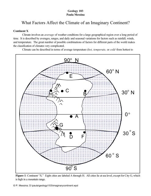
What Factors Affect the <strong>Climate</strong> of an <strong>Imaginary</strong> <strong>Continent</strong>?<br />
<strong>Continent</strong> X<br />
<strong>Climate</strong> involves an average of weather conditions for a large geographical region over a long period of<br />
time. It is described by averages, ranges, and daily and seasonal variations for factors such as rainfall, winds,<br />
and temperature. The great number of possible combinations of factors for different parts of the world makes<br />
the classification of climates very complicated.<br />
<strong>Climate</strong> can be described in terms of average temperature (hot, temperate, or cold–from hottest to<br />
90 o N<br />
E<br />
o<br />
60 N<br />
H<br />
C<br />
B<br />
o<br />
30 N<br />
A<br />
0<br />
o<br />
G<br />
D<br />
F<br />
30<br />
o<br />
S<br />
60<br />
o<br />
S<br />
90<br />
o<br />
S<br />
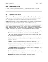
Figure 1: <strong>Continent</strong> “X.” Eight cities are labeled A through H. All cities lie at sea level, except for City G, which<br />
is high in a mountain range.<br />
© P. Messina; D:\paula\geology\103\imaginarycontinent.wpd
coldest), and humidity (humid, sub-humid, semi-arid, or arid–from most humid to most dry). In this<br />
investigation you will analyze a model, "<strong>Continent</strong> X," by studying the basic and modifying factors that<br />
contribute to its climates.<br />
Procedure<br />
Examine the geographic locations of cities A through H. Some of the factors you will need to consider<br />
include each one’s:<br />
• latitude (since that affects how much total insolation they receive);<br />
• proximity to an ocean (since coastal cities tend to have a more moderate climate than those<br />
that are inland);<br />
• elevation above sea level (because higher altitude cities will experience overall cooler temperatures);<br />
• planetary wind belt (since where weather systems come from affects local climate);<br />
• position relative to mountains (since those cities of the leeward side of mountain ranges will<br />
have drier/warmer conditions than those on the windward side).<br />
First, A Few Review Questions... (refer to your class notes, if necessary):<br />
1. As latitude increases, temperature _____________________.<br />
2. As altitude increases, temperature ___________________.<br />
3. Locations that are near large bodies of water tend to have ______________ summers and ___________<br />
winters than locations that are inland.<br />
4. Describe what happens to air as it rises (as it may over a mountain range): ______________________<br />
____________________________________________________________________________________<br />
___________________________________________________________________________________.<br />
5. Describe what happens to air as it sinks (as it may on the leeward side of a mountain range):<br />
6. The following latitudes are places of rising air, and low pressure: _____________________________<br />
7. The following latitudes are places of sinking air, and high pressure: __________________________<br />
8. Low pressure is associated with ___________________________ weather conditions, while high<br />
pressure is associated with ____________________________ weather conditions.<br />
© P. Messina; D:\paula\geology\103\imaginarycontinent.wpd
Procedures and Questions<br />
• Using the map in Figure 1, analyze the locations to develop hypotheses to address the following:<br />
9. Temperature range is the difference between the highest temperatures in the summer, and lowest<br />
temperatures in the winter. Explain the difference in temperature ranges expected at location D and location<br />
F. ________________________________________________________________<br />
_______________________________________________________________________________<br />
_______________________________________________________________________________<br />
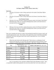
• To the right is a map showing the<br />
planetary winds, and high and low air<br />
pressure belts. Copy this diagram<br />
onto Figure 1. Label the HIGHS<br />
and LOWS, and draw the arrows<br />
showing planetary winds on <strong>Continent</strong><br />
X.<br />
10. Classify the climates of the seven locations<br />
labeled A, B, C, D, E, F, G and H in<br />
terms of general temperature and humidity<br />
characteristics. Use words such as "hot, "<br />
"cold," or "temperate" to describe general<br />
temperature, and "arid," "semi-arid," "subhumid"<br />
and "humid" to describe moisture<br />
characteristics.<br />
Temperature/Moisture<br />
A_________________________________<br />
LOW<br />
HIGH<br />
LOW<br />
HIGH<br />
LOW<br />
HIGH<br />
HIGH<br />
90 N<br />
90 N<br />
(Zone of Divergence)<br />
60 N<br />
(Zone of<br />
Convergence)<br />
30 N<br />
0<br />
30 S<br />
(Zone of<br />
Divergence)<br />
(Zone of<br />
Convergence)<br />
(Zone of<br />
Divergence)<br />
60 S (Zone of Convergence)<br />
(Zone of Divergence)<br />
B_________________________________<br />
C_________________________________<br />
D_________________________________<br />
E_________________________________<br />
F_________________________________<br />
G_________________________________<br />
H_________________________________<br />
© P. Messina; D:\paula\geology\103\imaginarycontinent.wpd