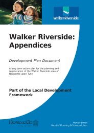
Fig. 1.1 - <strong>Study</strong> <strong>Area</strong> N A&P Tyne Fisher Street White Street Station Rd N Shepherd Offshore Walker Road Duco Wellstream Wincomblee Road <strong>Study</strong> area boundary Individual site boundary 2 Colin Buchanan
www.cbuchanan.co.uk 1. Introduction 1.1 The <strong>Study</strong> Newcastle City Council (NCC) Economic Development Division appointed Colin Buchanan in November 2004 to carry out a feasibility study <strong>for</strong> a Newcastle industrial area, Walker Riverside. Specialist consultants have joined Buchanan: - Wardell Armstrong, <strong>for</strong> desk-top investigation of ground conditions - Gavin Black, <strong>for</strong> property advice and financial viability - Turner and Townsend, <strong>for</strong> project cost analysis The objectives of <strong>the</strong> overall study were agreed through <strong>the</strong> initial brief, our response to it and <strong>the</strong> initial project meetings. They are: - Definition of key parameters and recommendations <strong>for</strong> <strong>the</strong> future of <strong>the</strong> area in relation to <strong>the</strong> current offshore/marine cluster vision. - Improvement of <strong>the</strong> interface with <strong>the</strong> adjacent residential area, taking into account <strong>the</strong> proposals of <strong>the</strong> Places <strong>for</strong> People Walker Riverside Masterplan (2004). - Revision of access arrangements to <strong>the</strong> area and, in particular, to some poorly served sites. - Definition of measures to streng<strong>the</strong>n <strong>the</strong> identity and image of <strong>the</strong> area and promote local pride. - Preparation of “packages” of urban design, infrastructure and property improvements, which will enhance <strong>the</strong> economic prosperity of <strong>the</strong> area. 1.2 The Report 1.2 The <strong>Area</strong> The area covered by <strong>the</strong> study is <strong>the</strong> Newcastle Walker Riverside, which is <strong>the</strong> 70 hectare industrial area located at <strong>the</strong> eastern boundary of <strong>the</strong> city of Newcastle between <strong>the</strong> Tyne and Walker Road. The study area is a narrow strip of land running along <strong>the</strong> river on a north/south axis and has an overall river frontage of 2.8 km. There are major differences in level within <strong>the</strong> strip, which in some cases (Wincomblee Road south) shelter <strong>the</strong> industrial sites from <strong>the</strong> residential neighbourhoods. In o<strong>the</strong>r cases, however, steep slopes restrict local access to sites: this is particularly severe along White Street and east of Fisher Street. The site is located 10 miles from Newcastle International Airport, 4 miles from Newcastle Central Railway Station, <strong>the</strong> A1(M) and A19. The ferry terminal to Scandinavia is also a few miles downstream, at North Shields. The area is a Strategic Site within Competitive Newcastle, <strong>the</strong> ten year economic development strategy launched by <strong>the</strong> City Council in 1999. Located in <strong>the</strong> area are a cluster of companies active in <strong>the</strong> marine, offshore and engineering sectors. “Anchors” to <strong>the</strong> area are three companies: Duco and Wellstream (global offshore manufacturers) and Sheperd Offshore, a marine logistics company who also manage <strong>the</strong> public deep water quay on behalf of <strong>the</strong> Council. A key site is that of A&P Tyne, which was part of <strong>the</strong> North Tyneside shipbuilding cluster including Swan Hunter and AMEC, and which has recently closed. This report is <strong>the</strong> final outcome of <strong>the</strong> study and comprises <strong>the</strong> reports of <strong>the</strong> previous stages of work. Accordingly it is subdivided in <strong>the</strong> following main sections, which correspond to <strong>the</strong> study main stages: - Section 1: Baseline Assessments - Section 2: Strategic Options - Section 3: Project Packages Each section is <strong>the</strong>n subdivided in chapters, according to different topics. Associated reports are <strong>the</strong> Ground Condition Report, as part of Stage 2 of <strong>the</strong> study, produced by Wardell Armstrong, <strong>the</strong> Cost Estimates <strong>for</strong> <strong>the</strong> project packages (produced by Turner & Townsend and summarised in Section 3) and a Colin Buchanan report on <strong>the</strong> feasibility of transferring freight traffic on Fossway, which in<strong>for</strong>med <strong>the</strong> Strategic Options. Walker Riverside <strong>Feasibility</strong> <strong>Study</strong> Section 1 - p. 3