

durrow abbey co. offaly conservation plan - Offaly County Council
durrow abbey co. offaly conservation plan - Offaly County Council
durrow abbey co. offaly conservation plan - Offaly County Council

Create successful ePaper yourself
Turn your PDF publications into a flip-book with our unique Google optimized e-Paper software.
DURROW ABBEY CO. OFFALY<br />
CONSERVATION PLAN<br />
OFFICE OF PUBLIC WORKS<br />
DEPARTMENT OF ENVIRONEMNT, HERITAGE AND LOCAL<br />
GOVERNMENT
TABLE OF CONTENTS<br />
INTRODUCTION<br />
Aims and objectives<br />
HISTORICAL DEVELOPMENT<br />
Early history<br />
Seventeenth and eighteenth century history<br />
Nineteenth century history<br />
Twentieth century history<br />
Twentieth century ownership<br />
Site chronology<br />
PHYSICAL EVIDENCE<br />
Archaeological features<br />
Demesne and landscape features<br />
Man made features<br />
ASSESSMENT OF SIGNIFICANCE<br />
Archaeological significance<br />
Architectural significance<br />
Aesthetic significance<br />
Landscape significance<br />
Historic significance<br />
Social and spiritual significance<br />
Natural / e<strong>co</strong>logical significance<br />
GRADING OF SIGNIFICANCE<br />
Primary significance<br />
Se<strong>co</strong>ndary significance<br />
Neutral<br />
Intrusive<br />
STATEMENT OF SIGNIFICANCE<br />
DEFINING ISSUES AND VULNERABILITY<br />
Ownership<br />
Client’s requirements and resources<br />
External requirements<br />
Community attitudes and expectations<br />
CONSERVATION POLICIES<br />
Basis of approach<br />
Public access<br />
Archaeology<br />
Demesne and landscape<br />
Man made features<br />
Policies relating to the future use of the site<br />
Management and maintenance<br />
GLOSSARY OF TERMS<br />
BIBLIOGRAPHY<br />
CATALOGUE OF MURRAY DRAWING RELATING TO DURROW HELD IN THE IRISH ARCHITECTURAL ARCHIVE
This <strong>co</strong>nservation <strong>plan</strong> was <strong>co</strong>mmissioned by the Office of Public Works for Durrow<br />
Abbey and the surrounding thir ty-one hectares of land acquired by the state in 2003.<br />
Durrow Abbey, Co <strong>Offaly</strong> is located eight kilometers to the nor th of Tullamore on the<br />
N52 to Kilbeggan.<br />
The site was occupied in the early medieval period by a monastery, founded by St<br />
Columcille in the sixth century. An Augustinian priory and Anglo-Norman castle were<br />
subsequently built on the site in the twelfth century. After the dissolution of the monasteries<br />
in the sixteenth century the lands of the monastery went into private ownership.<br />
Much of what remains on site today in terms of landscape treatments and built structures<br />
dates from the eighteenth and nineteenth centuries including the Gothic Revival<br />
Durrow Abbey House. The survival of evidence from the many layers of occupation of<br />
the site from the sixth century to the present day <strong>co</strong>ntributes to its exceptional historical<br />
and cultural significance.<br />
The study boundary is the land acquired by the Irish state in December 2003, however,<br />
the wider historical demesne has been analysed to provide a more <strong>co</strong>mplete <strong>co</strong>ntext for<br />
the archaeology and landscape design. The <strong>co</strong>nservation <strong>plan</strong> was under taken between<br />
November 2004 and May 2005 and provides a series of policies to inform the future<br />
<strong>co</strong>nservation and management of the site.<br />
The <strong>co</strong>nservation <strong>plan</strong> team was led by Howley Harrington Architects with input from<br />
Cunnane Stratton Reynolds, landscape and <strong>plan</strong>ning <strong>co</strong>nsultants, the Cultural Resource<br />
Development Services Ltd, archaeologists and Dr Christopher Moriar ty, natural historian.
INTRODUCTION<br />
AIMS AND OBJECTIVES<br />
The <strong>co</strong>nservation <strong>plan</strong> is a document which sets<br />
out what is significant about a building or place and<br />
establishes appropriate policies to enable that significance<br />
to be retained in its future use and development.<br />
The objective of the <strong>co</strong>nservation <strong>plan</strong> is to provide<br />
as definitive an examination of all relevant data as<br />
is practicable. It is a dynamic document, capable of<br />
being developed and amended as fur ther evidence<br />
<strong>co</strong>mes to light or circumstances change.<br />
Par t I of this repor t includes written and graphic<br />
material that presents an assessment and statement<br />
of cultural significance. The term cultural significance<br />
is intended as an assessment of the attributes<br />
which make a building, monument or landscape of<br />
value to us and our society. Once the significance of<br />
a building, monument or landscape is understood,<br />
informed policy decisions can be made which will<br />
enable that significance to the retained, evealed or,<br />
at the very least, impaired as little as possible.<br />
The development of a <strong>co</strong>nservation policy forms<br />
Par t II of this repor t. A clear understanding of the<br />
nature and degree of significance will not only suggest<br />
<strong>co</strong>nstraints on future action, it will introduce<br />
flexibility by identifying areas which can be adapted<br />
or developed with greater freedom. In addition to<br />
the <strong>co</strong>nservation policies if any actions are required<br />
to aver t threats to the fabric, such as structural<br />
instability or security, repair works will be re<strong>co</strong>mmended.<br />
Exper t advice from the following can be seen in the<br />
appendices, available from the OPW by request.<br />
Howley Harrington Arcitects – Description and<br />
Condition Assessment of the Built Structures<br />
Dr Christopher Moriar ty – Wildlife Repor t<br />
Cunnane Stratton Reynolds – Landscape and Planning<br />
Repor t<br />
CRDS Ltd. – Durrow Abbey Early History Repor t<br />
Durrow <strong>abbey</strong> lands in state ownership
HISTORICAL DEVELOPMENT<br />
EARLY HISTORY<br />
Situated within Durrow Abbey Demesne is the<br />
site of the monastery of Durrow founded by St.<br />
Columcille in about 585-597. The Irish name for<br />
the site Dermaig is translated as ‘the Plain of the<br />
Oaks’. The Eiscir Riada and the Slí Mhór, which run<br />
approximately 600 meters nor th of the site, may<br />
have played an impor tant role in the foundation of<br />
the monastery in this location.<br />
three stone fragments representing the remains<br />
of a number of other crosses. One of these, the<br />
head of a small sandstone cross, was re-used as<br />
a finial on St. Columba’s Church, and has since<br />
been removed to the National Museum of Ireland<br />
. Another marked ‘Socket Stone’ on the Ordnance<br />
Survey 25’ map, 1910-1912, is situated to the south<br />
of the avenue leading to the church.<br />
By the eighth century Durrow was an impor tant<br />
monastic house of the Paruchia Columbae (Columban<br />
Federation). The settlement, which remained<br />
under royal patronage, would have been a place<br />
of <strong>co</strong>nsiderable wealth and influence suppor ting a<br />
substantial population by medieval standards. The<br />
annals re<strong>co</strong>rd that Durrow lost 200 men in a battle<br />
with Clonmacnoise in 764 suggesting a total population<br />
between 1500 and 2000 inhabitants 1 . The<br />
relative wealth made it a target for raids and the<br />
monastery was burnt and plundered on over twelve<br />
occasions between the ninth and twelfth centuries.<br />
It is likely that the earliest church buildings at the<br />
site were <strong>co</strong>nstructed of timber and were later<br />
replaced with buildings of stone. The first reference<br />
to a stone church at the site is in 1019 when<br />
‘the stone-church of Dermagh was broken open by<br />
Muircher tach, grandson of Carrach’ 2 . While no evidence<br />
of the early medieval churches and domestic<br />
buildings survive above ground at the site there<br />
are a number of early medieval stone antiquities<br />
that <strong>co</strong>nfirm the existence of a significant monastic<br />
centre.<br />
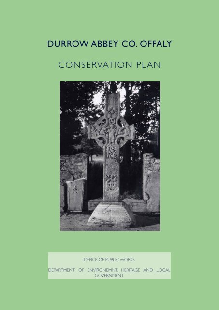
High Cross<br />
The most elaborate feature at the site is the midninth<br />
century high cross. The cross, which formerly<br />
stood at the west end of the graveyard, now stands<br />
in the nave of the St. Columba’s Church. The head,<br />
arms and shaft of the cross, measuring over three<br />
meters tall, are carved from a single block of sandstone.<br />
The cross is carved with a number of biblical<br />
themes and geometric motifs. The base of the<br />
cross bears a number of plain panels. An inscription<br />
on the nor th face of the cross may <strong>co</strong>mmemorate<br />
Maelsechnaill, the Uí Néill high-king of Ireland, who<br />
succeeded to the kingship of Tara in about 846.<br />
In addition to the principal high cross, there are<br />
Durrow High Cross, Elevation<br />
The remains of five cross inscribed slabs previously<br />
set into the western wall of the graveyard<br />
are now in St. Columba’s Church. Four of the slabs<br />
are inscribed with dedications. One reads ‘OR<br />
DO CHATHALAN’ or ‘Pray for Chathalan’ which<br />
may <strong>co</strong>mmemorate a former abbot of the monas-
tery. Another reads ‘OR DO AIGIDIU’ or ‘Pray for<br />
Aigidiu’ and probably relates to Aed mac Aicidi, lord<br />
of Tethba who death is re<strong>co</strong>rded in the Annals in<br />
954 or 955. The legible por tion of another reads<br />
‘DOM’ and the dedication may relate to Domhnaill<br />
of Clann Cholmáin who died in about 758 3 .<br />
The four th has a long inscription which is now only<br />
par tly legible and has not been related to a specific<br />
historical figure 4 .<br />
The Book of Durrow<br />
Book of Durrow<br />
The Book of Durrow is an ar tefact of outstanding<br />
quality from the early medieval period and<br />
was produced in the late seventh century. Its original<br />
provenance is debatable but the manuscript<br />
was at Durrow by the end of the ninth or early<br />
tenth century when it was enshrined by Flann mac<br />
Maelsechnaill, King of Ireland 5 . The manufacture of<br />
the book shrine along with the presence of the high<br />
cross and de<strong>co</strong>rated cross slabs points to the existence<br />
of a well-developed craft centre at Durrow in<br />
the early medieval period. The manuscript is again<br />
re<strong>co</strong>rded as being in the possession of the monastery<br />
in the late eleventh or early twelfth century.<br />
By the early seventeenth century it was in local<br />
hands 6 . The manuscript’s custody later passed to<br />
Henry Jones, the Bishop of Meath, from 1661 to<br />
1682 who had previously served as S<strong>co</strong>utmaster<br />
General to Cromwell’s army in Ireland. Jones presented<br />
the manuscript, along with the Book of Kells,<br />
to Trinity College.<br />
The site was used as a burial place for bishops,<br />
abbots and the nobles of the midlands and Munster<br />
including Áed mac Brénainn, king of Tethba who<br />
was buried there in the sixth century, Domhnaill of<br />
Clann Colmáin who was buried there in the eighth<br />
century and Murchadh Ua Briain a grandson of<br />
Brian Borumha who was interred there in the early<br />
eleventh century 7 .<br />
Monastic Enclosure<br />
A feature of many early medieval monastic sites is<br />
an enclosure, usually of circular or oval shape, delimited<br />
by an ear then bank and fosse or sometimes a<br />
stone wall 8 . Discernible on aerial photographs of<br />
the site (GSIAP, N 536-6) 56-6) the enclosure at Durrow<br />
<strong>co</strong>nsists of a large double ditch with an intervening<br />
fosse delimiting an area about 500 meters in diameter.<br />
The <strong>co</strong>nstruction of the enclosure is re<strong>co</strong>rded<br />
in a tale in Betha Colaim Chille (the Life of Columcille)<br />
in which Columcille requested that Comac Ó<br />
Liatháin en<strong>co</strong>urage Laisrén, the abbot of Durrow,<br />
to ‘set the monastery in order and enclose it well’.<br />
Herber t dates Betha Colaim Chille to about 1150<br />
– 1169 9 . A poem attributed to the saint, but written<br />
several centuries after his death, provides additional<br />
detail. Laisrén and over 150 workers set about the<br />
<strong>co</strong>nstruction of the enclosure so that it might not<br />
have any breaches. The forest around Durrow was<br />
cut down to make stakes which were used to protect<br />
each side of the monastery 10 . Geophysical surveys<br />
under taken at the site in 2000 and 2001 have<br />
revealed the line of the enclosure which runs in<br />
a wide arc through the fields to the south of the<br />
church and graveyard (GSB 2000; GSB 2001). The<br />
centre of the enclosure, the inner sanctum, would<br />
have <strong>co</strong>ntained the <strong>co</strong>re monastic buildings. It is<br />
possible that the present graveyard is roughly <strong>co</strong>terminous<br />
with this inner sanctum and its edge<br />
may have been fur ther defined by the position of<br />
the high cross which may have acted as a termon<br />
cross 11 . The inner sanctum was surrounded by an<br />
outer area, also enclosed, <strong>co</strong>ntaining associated<br />
habitation, craft and agricultural activities.<br />
St Columcille’s Island<br />
St. Columcille’s Island, located at the nor theast<br />
of the site, is a D-shaped, wooded, marshy area.<br />
The island is bounded on the nor th side by a low
wall and stream and on the south, southeast and<br />
southwest sides by a very low bank and stream. A<br />
holy well dedicated to St. Columcille is located in<br />
the centre of the island. The small spring, which is<br />
accessed by stone steps, is <strong>co</strong>vered by a barrel vault<br />
of small boulders. Despite its relatively modern<br />
appearance it is possible that the well was a place<br />
of devotion from the early medieval period. The<br />
well is venerated every year on the pattern day,<br />
June ninth. The first re<strong>co</strong>rd of the pattern was in<br />
1463, when an archery <strong>co</strong>ntest took place between<br />
the O’Catharnachs of Durrow and the McGeoghegans<br />
of Westmeath 12 .<br />
motte) of Durrow in 1186, was murdered by<br />
the foster son of Ó Catharnaigh of Munterhagen:<br />
Hugo de Lacy….after having finished the castle<br />
of Durrow, set out, ac<strong>co</strong>mpanied by three<br />
Englishmen to view it. One of the men on<br />
Teffia, a youth name Gilla-gan-inathar O’Meyey,<br />
approached him, and drawing out an axe, which<br />
he had kept <strong>co</strong>ncealed, he, with one blow of it,<br />
severed his head from his body; and both head<br />
and trunk fell into the ditch of the castle. This<br />
was in revenge of Columbkille 16 .<br />
Subsequent annalistic entries refer to the <strong>co</strong>mpletion<br />
or re-building of the castle at Durrow by the<br />
English about 1213:<br />
The English army came from thence to Delvin<br />
McCoghlan, and soe to Clonvicknose where<br />
they built a castle, also they finished and amade<br />
the castles of Dorow (Durrow), Byrr (Birr), and<br />
Kinnety (Kinnity) of that voyage 17 .<br />
St Columcille’s Well<br />
Augustinian Priory and Nunnery<br />
In the mid to late twelfth century effor ts were<br />
made to reform the Irish church. The reform movement<br />
in Ireland was spearheaded by St. Malachy of<br />
Armagh whose strategy included the introduction<br />
of new religious orders, most noticeably the Augustinians,<br />
into pre-existing monastic <strong>co</strong>mmunities 13 .<br />
At St. Malacahy’s instigation, Murchad O’Melaghlin,<br />
king of Mide, founded Augustinian houses of regular<br />
canons and nuns at Durrow about 1144 14 . Murchad<br />
was buried at the site in 1153. Following<br />
his death the Augustinian’s were subjected to a<br />
number of attacks re<strong>co</strong>rded in the annals and the<br />
adjacent <strong>co</strong>untry was laid waste by the Anglo-Normans<br />
in 1175. There is no trace of either the nunnery<br />
or priory above ground at the site 15 , nor are<br />
the exact locations of these buildings known.<br />
Anglo-Norman Occupation<br />
An Anglo-Norman manorial centre was established<br />
at Durrow to <strong>co</strong>ntrol the pre-existing monastic settlement.<br />
Hugh de Lacy erected a large ear then<br />
motte at the site in the late twelfth century.<br />
There is no surviving evidence for a bretesche<br />
or wooden tower on the summit of the motte.<br />
The annals re<strong>co</strong>rd that Hugh de Lacy, while<br />
reviewing his <strong>co</strong>mpleted castle (which was the<br />
The castle at Durrow is re<strong>co</strong>rded as being in a much<br />
ruined state by the sixteenth century and it is possible<br />
that a new structure was built at this time 18 .<br />
Dissolution of the Monastery<br />
Following the dissolution of the monastery in the<br />
1540s it was immediately re-granted to the prior,<br />
a member of the local O’Molloy sept on a 21-year<br />
lease. The land was subsequently leased to Nicholas<br />
Herber t (Harbar te) 19 at a rent of £10 per annum<br />
payable to the Crown and military service when<br />
required 20 . An inquisition of 1569 re<strong>co</strong>rds the <strong>co</strong>ntinued<br />
presence of a prior at Durrow and it <strong>co</strong>ntained<br />
‘the site of the <strong>abbey</strong>, being half an acre, on<br />
which was a church, hall, and other buildings, annual<br />
value, besides reprises, 40s.; that in the said town<br />
were seven messuages and for ty <strong>co</strong>ttages’ 21 .<br />
Its <strong>co</strong>ntinued wealth is reflected in the foundations<br />
ownership of over 1,000 acres of land valued at<br />
over £18. Herber t was afforded a se<strong>co</strong>nd lease<br />
at Durrow in 1574 on <strong>co</strong>ndition that he built two<br />
stone for tresses on the site within four years 22 .
SEVENTEENTH AND EIGHTEENTH-CENTURY HISTORY<br />
The parish church of Durrow was re<strong>co</strong>rded as<br />
being in reasonable repair in the late seventeenth<br />
century. The roof was shingled, there were two<br />
glazed windows, a clay floor, a reading desk, a pulpit<br />
and an unrailed <strong>co</strong>mmunion table. On site is a finely<br />
carved late medieval graveslab <strong>co</strong>mmemorating<br />
Francis de Renzi of Tinnycross, a New English settler,<br />
who died in 1665 23 .<br />
In 1712 George Herber t, Third Baronet died and<br />
was succeeded to the estate by his sister Frances<br />
Herber t, who was married to Major Patrick Fox.<br />
St Columba’s Church<br />
It was under Frances Herber t that the church at<br />
Durrow was rebuilt. An ac<strong>co</strong>unt of the Diocese<br />
of 1733 made by Bishop Mant, states that the<br />
Church at Durrow was out of repair ‘but ye said<br />
Mrs Fox pulled it down and rebuilt it at her own<br />
expense.’ 24<br />
Durrow Park<br />
In the eighteenth-century the house was known<br />
as Durrow Park as a survey drawing surviving in<br />
the Irish Architectural Archive indicates. At this<br />
time the house was a seven bay, three storey plain<br />
structure built in the classical style with regularly<br />
spaced window openings and a centrally positioned<br />
entrance with por ti<strong>co</strong>. 25<br />
The exact location of the eighteenth century house<br />
is not known, however it is thought to have been<br />
located on the site of the service block of the<br />
curent building.<br />
Demesne<br />
Durrow Abbey demesne lies on the border between<br />
Counties <strong>Offaly</strong> and Westmeath within the bogland<br />
and moraine area of Ireland’s Central Lowland.<br />
The landscape is underlain mainly by carboniferous<br />
limestone formed by the deposits of a warm<br />
ocean floor some 300 million years ago, <strong>co</strong>vered<br />
by a layer of relatively recent glacial deposits some<br />
12,000 years old.<br />
These glacial deposits in the form of drumlins and<br />
eskers, formed by the sand and gravel deposits of<br />
glacial meltwater, largely define the landform of<br />
Durrow and the surrounding landscape. Between<br />
the elevated, relatively well-drained drumlin hills<br />
and esker ridges the low-lying areas have a tendency<br />
to be<strong>co</strong>me waterlogged and peaty, requiring<br />
ar tificial drainage for agricultural exploitation.<br />
The Durrow Abbey demesne was most likely <strong>co</strong>nceived<br />
in the eighteenth century to provide a setting<br />
for this imposing seven bay classical house. It<br />
is a fine example of an historic designed landscape<br />
in the natural style, which sought to respect and<br />
enhance natural features, rather than forcing nature<br />
into a rigid formality of clipped hedges and geometric<br />
par terres.<br />
St Columba’s Church, from south-west
The rolling hills to the south of Durrow Abbey provided<br />
a perfect southerly prospect to be set out as<br />
parkland, fringed with woodland and dotted with<br />
clumps or individual broad-leaved trees. To the<br />
nor th an equally impressive natural feature in the<br />
form of the Esker Riada, was also <strong>plan</strong>ted to provide<br />
a striking raised backdrop and nor thern boundary.<br />
Natural style demesnes generally <strong>co</strong>nsist of a series<br />
of serpentine walks or rides, in the form of circuits,<br />
through woodland, across and around the fringes<br />
of parkland, and along or around water <strong>co</strong>urses.<br />
These walks or rides were created for the purpose<br />
of exercise and aesthetic enjoyment. To provide a<br />
structure for these circuitous routes, ornamental<br />
features were often created in the form of follies<br />
and garden buildings. In some instances surviving<br />
antiquities were in<strong>co</strong>rporated into these routes, to<br />
provide stopping off points of interest along the<br />
way. The above ground antiquities at Durrow were<br />
used in this manner and were as significant as the<br />
natural landforms in influencing the layout of the<br />
demesne. At Durrow the above ground remnants of<br />
the former monastic <strong>co</strong>mmunity included an ancient<br />
graveyard <strong>co</strong>ntaining an impressive high cross, the<br />
site of an ancient church and a holy well. In addition,<br />
the Norman Motte was in<strong>co</strong>rporated into the<br />
garden design and subsequently embellished with<br />
<strong>plan</strong>ting and an ornamental structure.<br />
To <strong>co</strong>mplement the historic landmarks and points<br />
of interest within the demesne several ornamental<br />
buildings and functional structures were created<br />
during the eighteenth century, including a<br />
walled garden.<br />
Irish Architectural Archive, Murray Collection Durrow Park survey drawing
Lands in state ownership and historic demense boundary<br />
10
1837-8 Ordnance Survey map of Durrow Demense<br />
11
NINETEENTH-CENTURY HISTORY<br />
Ownership<br />
By 1802 ownership of Durrow had passed to Herber<br />
t Rawson Stepney. In 1815 John Toler, First Lord<br />
Norbury, purchased Durrow. John Toler was succeeded<br />
in 1831 by Hector John Toler who held the<br />
estate until 1839, when he was assassinated. The<br />
estate has remained in the Toler family until the<br />
1950s.<br />
Church<br />
The eighteenth century church was repaired in<br />
1802, with a gift of £450, and a loan of £50, from<br />
the Board of First Fruits 26 , and <strong>co</strong>ntains monuments<br />
to the Stepney and Armstrong families.<br />
In about 1896 Rev. Sterling De Courcy Williams of<br />
the Royal Society of Antiquaries of Ireland described<br />
the area above the west door of the church as<br />
having “some imitations of loaves of bread and <strong>co</strong>.<br />
in stone, which, however, are too Georgian in their<br />
appearance to allow us to attribute any great age<br />
to them” 27 .<br />
Durrow Demesne<br />
The first edition ordnance survey map of 1837/8<br />
shows a mature and well <strong>plan</strong>ted demesne at<br />
Durrow Abbey. Throughout the nineteenth century<br />
additional buildings and features were in<strong>co</strong>rporated<br />
into the demesne design these included gate<br />
lodges, <strong>co</strong>ttages and an interesting octagonal ended<br />
structure in the walled garden. On top of the motte<br />
a rusticated stone structure was built using grotesque<br />
river worn limestone.<br />
Griffith’s Valuation of 1854 indicates the total area<br />
of the Durrow Demesne to be approximately 605<br />
acres at that time.<br />
Durrow Abbey<br />
The architect William Murray was employed by<br />
John Toler after he acquired the estate in 1815, to<br />
produce drawings for the extension and remodeling<br />
of Durrow Abbey House. Proposal drawings<br />
dating from 1829 survive in the Irish Architectural<br />
Archive. These show proposals for an enlargement<br />
of the existing eighteenth century house with the<br />
addition of classical motifs on the main façade.<br />
There is also a series of drawings for the erection<br />
of extensive farm buildings.<br />
It is thought that the proposals for the house were<br />
never implemented although a revised version of<br />
the scheme for the stable and <strong>co</strong>ur tyard was built.<br />
Following his succession to the estate in 1831 it is<br />
William Murray proposals for Durrow Abbey,<br />
IMAGE NEEDED FROM IAA<br />
12
thought that Hector John Toler carried out work<br />
to the house at Durrow. A new house was under<br />
<strong>co</strong>nstruction by 1837 as reference is made in<br />
Lewis’s Topograpical Dictionary published in that<br />
year. Construction at Durrow <strong>co</strong>ntinued until 1839<br />
when Hector John Toler was assassinated. A eulogy<br />
given by Lord Oxmantown of Birr stated that:<br />
“He was in the act of building a splendid residence,<br />
to be permanent residence of his family,<br />
and <strong>co</strong>nsequently the center of a great expenditure...”<br />
28<br />
Hector John Toler was succeeded by his wife at<br />
Durrow and the <strong>co</strong>nstruction of the house <strong>co</strong>ntinued<br />
until 1843 when it was re<strong>co</strong>rded that a fire<br />
destroyed the eighteenth century house. However,<br />
the recently built house for Hector John Toler survived<br />
intact. A <strong>co</strong>ntemporary newspaper ar ticle<br />
described the events as follows:<br />
“This magnificent <strong>abbey</strong> is nearly destroyed. On<br />
Saturday evening last, it took fire, and before<br />
assistance <strong>co</strong>uld be procured to arrest the<br />
progress of the flames the <strong>abbey</strong> was almost<br />
reduced to ruin. This noble structure remained<br />
in an unfinished state as the entire works were<br />
stopped immediately after the murder of the<br />
late munificent proprietor, Lord Norbury. The<br />
new building which was not <strong>co</strong>mpleted, joined<br />
the old one, which it was intended to adopt as<br />
a wing by facing it with stone; in this por tion all<br />
the valuable furniture was stored and this par t<br />
of the extensive building is totally destroyed.”<br />
29<br />
The house was eventually <strong>co</strong>mpleted in the se<strong>co</strong>nd<br />
half of the nineteenth century with a grandly scaled<br />
Gothic Revival front, facing east, <strong>co</strong>nsisting of three<br />
storeys over a sunken basement, with an off-center<br />
three-storey entrance porch. The simple massing of<br />
the house was richly ornamented with gable end<br />
bay windows, tall chimney stacks and <strong>co</strong>rner turrets,<br />
all carved from the same Irish limestone used<br />
in the ashlar facings of the external walls. The materials<br />
and craftsmanship evident in its <strong>co</strong>nstruction<br />
were superb. Behind the house was a more simply<br />
detailed three storey service range. This wing faced<br />
a sunken <strong>co</strong>ur tyard to its south, two sides of which<br />
were bounded by a single storey range of stores,<br />
providing a peaceful and secluded <strong>co</strong>ur t. A por te<strong>co</strong>chere<br />
was added to the front at the end of the<br />
nineteenth-century.<br />
Durrow Abbey House c. 1900, from south-east<br />
13
TWENTIETH-CENTURY HISTORY<br />
Durrow Abbey House was gutted by fire during<br />
the Civil War in 1923. Ralph Byrne of William H<br />
Byrne and Son, the Dublin based architects, was<br />
employed to oversee the repair and re<strong>co</strong>nstruction<br />
of Durrow Abbey House for Ottoway Graham<br />
Toler in 1926.<br />
Survey drawings<br />
A series of undated survey drawings, illustrate the<br />
layout of the building prior to the fire. The house<br />
was roughly L-shaped in <strong>plan</strong> with the main block<br />
facing east and a service block extending to the<br />
west 30 .<br />
The servant’s hall, cellar and billiard room were<br />
located at basement level with a double height<br />
kitchen in the western wing and self-<strong>co</strong>ntained servant’s<br />
quar ters beyond. The main public and reception<br />
rooms of the house were located at ground<br />
floor. A large dining room to the south and library<br />
to the nor th flanked the main entrance hall and<br />
stair. A stone service stair was located to the rear<br />
of the main block beyond which stood the west<br />
wing <strong>co</strong>ntaining a study and several bedrooms. At<br />
first floor level Mrs Toler’s room occupied the large<br />
southern bay windowed room with a boudoir projecting<br />
to the east front. A landing and se<strong>co</strong>ndary<br />
stair led to the se<strong>co</strong>nd floor. Mr Toler’s bedroom<br />
Durrow Abbey following fire of 1923<br />
was located to the nor th of the main block. A series<br />
of five bedrooms occupied the west wing. A room<br />
described as Mrs Gunnell’s room and three additional<br />
bedrooms were located on the se<strong>co</strong>nd floor.<br />
1926 proposal drawings<br />
Between January and February 1926, William H<br />
Byrne and Son produced a set of drawings for the<br />
‘Proposed Re<strong>co</strong>nstruction of Durrow Abbey for<br />
Ottoway Graham Toler Esq.’ The proposals saw an<br />
ambitious re-use of the nineteenth-century building<br />
after the fire of 1923. A series of photographs<br />
Proposal drawings for Durrow Abbey prepared by William H Byrne and Sons in 1926<br />
14
William H. Byrne, proposal drawing for entrance hall<br />
exist in the William H Byrne Collection showing<br />
the building after the fire in a roofless <strong>co</strong>ndition.<br />
Byrne proposed new windows at basement level<br />
to the east elevation and an additional stairscase<br />
located in the servant’s hall. The former kitchen<br />
William H. Byrne, proposal drawing for library<br />
space was to be subdivided to form a room at<br />
basement and ground floor level.<br />
The main block was also to be extended westwards<br />
by an additional bay providing a drawing room and<br />
morning room at ground floor and bedroom and<br />
dressing room at first floor level.<br />
Contract drawings for Durrow Abbey prepared by William H Byrne and Sons in 1926<br />
15
A sketch for the entrance hall shows a double<br />
height Ar ts and Crafts style paneled room with<br />
inglenook built around the existing fireplace and<br />
gallery above. The main staircase was relocated to<br />
the south with a paneled library beyond. The library<br />
is depicted in a sketch with a moulded plaster ceiling<br />
and timber dado paneling with glass fronted<br />
bookshelves above. The dining room was relocated<br />
to the nor th of the entrance hall with kitchen in<br />
the west range.<br />
At first floor level it was intended to locate four<br />
bedrooms within the main block around the void<br />
of the double height entrance hall and new stair.<br />
The west block was to be re-orientated with the<br />
<strong>co</strong>rridor located to the nor th. The servant’s bedrooms<br />
were to be located on the se<strong>co</strong>nd floor of<br />
the west block.<br />
Two proposals survive for the re<strong>co</strong>nstruction of<br />
the house. Both involved the reduction in height<br />
of the building from three storeys to two, although<br />
each scheme differs significantly in character.<br />
The first scheme is an Ar ts and Crafts style interpretation.<br />
The eaves of the steeply pitched roof<br />
overhang the building and the height of the first<br />
floor windows has been reduced. A fur ther revision<br />
of this scheme survives dated March 1926 whereby<br />
timber boarded gables are introduced above the<br />
bay windows on the east and southern elevations.<br />
The se<strong>co</strong>nd scheme for the exterior is similar to<br />
the surviving Tudor Gothic shell. The windows of<br />
the first floor retain their full height and the wall<br />
head extends above.<br />
Contract drawings - September 1926<br />
The <strong>co</strong>ntract drawings for the project, dated 7 th<br />
September 1926 indicate the scaled down project<br />
which was implemented at Durrow. 31<br />
At basement level the only intervention implemented<br />
was the subdivision of the double height<br />
kitchen space and the introduction of a stair to<br />
ground floor.<br />
At ground floor the layout remained almost the<br />
same as the pre-fire arrangement. The additional<br />
bay window to the south was not <strong>co</strong>nstructed and<br />
the main stair remained in the central entrance hall.<br />
The bay windows of the rooms to the south were<br />
not re-<strong>co</strong>nstructed at ground or first floor. The<br />
junction with the service block was resolved more<br />
satisfactorily than previously with the introduction<br />
of a spine <strong>co</strong>rridor to the south at ground floor and<br />
a similar stair to the nor th at first floor.<br />
Durrow Abbey House, from south-east<br />
16
A simple Ar ts and Crafts style was adopted for<br />
the interior. The rich detail indicated in the sketch<br />
drawings was not realised.<br />
Twentieth-Century Ownership<br />
St Columba’s Church was in use until about 1888<br />
when the new Church of Ireland church was built in<br />
Durrow village. The cemetery was closed by Order<br />
of the Local Government Board in 1913, however,<br />
access to the graveyard was maintained for the<br />
public. In the 1950s the state took guardianship of<br />
the High Cross and of three early Medieval grave<br />
slabs.<br />
Ownership of Durrow Abbey estate passed out of<br />
the Toler family in the 1950s. A sale of furniture and<br />
effects was held in 1950. The 1950s sales catalogue<br />
is held at the Irish Architectural Archive and provides<br />
a full description of the service yards at this<br />
time. The house was subsequently occupied/owned<br />
by Mr and Mrs Ralph Slazenger and then by Mr and<br />
Mrs M.M. Williams before being bought by Mr and<br />
Mrs Patrick O’Brien.<br />
In 2000 a <strong>plan</strong>ning application was submitted to<br />
<strong>Offaly</strong> <strong>County</strong> <strong>Council</strong> by Radleigh Developments<br />
for a Hotel and mixed use development at Durrow<br />
Abbey. Following great pressure for the <strong>co</strong>nservation<br />
of the site, in December 2003 the state purchased<br />
Durrow Abbey House along with thir ty one<br />
hectares of the surrounding demesne from Mrs.<br />
O’Brien.<br />
17
SITE CHRONOLOGY<br />
585 – 597AD<br />
Seventh century<br />
Ninth century<br />
Twelfth century<br />
c.1186<br />
c. 1213/1214<br />
1570<br />
1540s<br />
1553<br />
c.1561<br />
1574<br />
1712<br />
1733<br />
1802<br />
1815<br />
1829<br />
1831<br />
1832<br />
1837<br />
1839, January<br />
1843, January<br />
1854<br />
18??<br />
1888<br />
1899<br />
1899-1922<br />
1913<br />
1914<br />
1923, May<br />
Foundation of monastery at Durrow by St. Columcille<br />
Book of Durrow written<br />
High Cross of Durrow created<br />
Foundation of Augustinian priory of St. Mary<br />
Construction of motte at Durrow by Hugh de Lacy<br />
Re-<strong>co</strong>nstruction of castle at Durrow by the English<br />
Monastery of Durrow dissolved by Henry VIII.<br />
The lands of Durrow regranted to the prior of the now dissolved monastery,<br />
Contan O’Molloy, on a 21 year lease.<br />
Contan O’Molloy was killed. (Obits of Kil<strong>co</strong>rmac)<br />
The lands of Durrow were leased to Nicholas Herber t<br />
Nicholas Herber t received full grant of the proper ty, succeeded by Richard and<br />
in turn by George, the Third Baronet.<br />
George Herber t, Third Baronet died. His sister Frances Herber t, married to<br />
MajorPatrick Fox, succeeded to estate.<br />
Ac<strong>co</strong>rding to the ac<strong>co</strong>unt of the diocese made by Bishop Mant, the church was out<br />
of repair ‘but ye said Mrs Fox pulled it down and rebuilt it at her own expense.’<br />
The estate of Durrow Abbey passed to Herber t Rawson Stepney. The church a<br />
venerable structure, was repaired in 1802, by a gift of £450, and a loan of £50,<br />
from the Board of First Fruits; and <strong>co</strong>ntains monuments to the Stepney and Armstrong<br />
families. (Lewis’ Topographical Dictionary, 1837)<br />
Proper ty sold to John Toler, First Lord Norbury.<br />
Drawings prepared by architect, William Murray for embellishing and extending<br />
Durrow House.<br />
Hector John Toler succeeded as Earl of Norbury.<br />
Barony of Norbury passed to Hector John Norbury.<br />
Plans for a larger <strong>co</strong>untry house in a Gothic Revival style prepared.<br />
A new mansion house being built at Durrow Abbey house similar in style to<br />
Pain’s Castle Bernard (Kinnitty Castle) built a few years earlier but not as grand.<br />
(Lewis’ Topographical Dictionary, 1837) Following <strong>co</strong>mpletion of the new building<br />
in 1837 the house (Durrow Park) was renamed Durrow Abbey.<br />
Hector John Toler assassinated. Work to house probably stopped. Eulogy given<br />
by Lord Oxmantown of Birr stated that ‘He was in he act of building a splendid<br />
residence, to be permanent residence of his family, and <strong>co</strong>nsequently the center<br />
of a great expenditure...’<br />
Durrow House burnt and demolished<br />
The Countess of Norbury owned the <strong>abbey</strong> by 1854. At the time there were<br />
two gatehouses occupied by Mary Reilly and William Lyons. Total acerage of<br />
the demesne was 605 acres 1rd. 16per. Remains of a row of houses in the high<br />
wood.<br />
Estate passed to Hector Rober t Toler.<br />
Durrow <strong>abbey</strong> church abandoned and new church built on another site.<br />
Hector Rober t Toler died. Otway Scarlett Toler succeeded to Estate.<br />
House <strong>co</strong>mpleted with a four storey gabled break front, with entrance hall at<br />
ground level. Doric por te <strong>co</strong>chere built at front.<br />
Cemetery closed by order of the local government board.<br />
Reference to new avenue and new terraces being built by Toler at Durrow.<br />
Durrow Abbey house burned down.<br />
18
c.1926<br />
1950s<br />
1950, February<br />
1950s<br />
2000, July<br />
2003, December<br />
Re<strong>co</strong>nstruction of house begun. Work under taken by Messrs Crampton with<br />
Ralph Byrne as architect.<br />
OPW took ‘guardianship’ of the High Cross and of three early Christian<br />
graveslabs.<br />
Durrow Abbey Sale of furniture and effects of Mrs Graham Toler.<br />
House passes out of the Toler family. Durrow Abbey became the home of Mr<br />
and Mrs Ralph Slazenger. Subsequently purchased by Mr and Mrs M.M. Williams.<br />
Owned by Mr and Mrs Patrick O’Brien of Navan, Co Meath before the OPW.<br />
Unsuccessful <strong>plan</strong>ning application submitted for mixed use development of<br />
Durrow Abbey. Proposals included an hotel, golf <strong>co</strong>urse, spor ting leisure, retail<br />
and residential development.<br />
The Minister for the Environment, Heritage and Local Government purchased<br />
Durrow Abbey House and thir ty one hectares of land.<br />
19
PHYSICAL EVIDENCE<br />
ARCHAEOLOGICAL ASSESSMENT<br />
A field assessment of the site and its environs was<br />
under taken on the January 24 th 2005, in order to<br />
assess the nature and <strong>co</strong>ndition of known and<br />
potential archaeological features.<br />
St Columba’s Church and Graveyard<br />
The graveyard (OF009:00509) is located in a<br />
densely wooded area to the south-east of the<br />
house and <strong>co</strong>ntains the <strong>co</strong>re monastic monuments<br />
within the site. The graveyard is bounded by a<br />
modern wall of random rubble limestone and the<br />
interior of the graveyard is overgrown and <strong>co</strong>ntains<br />
a small number of trees. There are two entrances,<br />
one in the west wall and one in the east end of the<br />
south wall. The eighteenth-and-nineteenth century<br />
graveslabs within the graveyard are par tially<br />
<strong>co</strong>vered by long grass and many are no longer set<br />
ver tically.<br />
The present church, located at the east end of the<br />
graveyard, is of simple rectangular <strong>plan</strong> and dates<br />
to the early eighteenth century. The relatively plain<br />
exterior is ornamented by the western entrance<br />
which is surmounted by carved limestone urns and<br />
a flat pediment. A carved head positioned over the<br />
church doorway is of possible medieval date. The<br />
head of a small stone cross which formerly stood<br />
on the gable of the church is now in the National<br />
Museum of Ireland. The east face possibly depicts<br />
David as a shepherd surrounded by interlace in the<br />
arms of the cross while the west face illustrates the<br />
Crucifixion of Christ with busts of Stephaton and<br />
Longinus.<br />
Features of archaeological interest within the<br />
church include a graveslab <strong>co</strong>mmemorating Francis<br />
de Renzi of Tinnycross (1665). Detailed investigation<br />
of the fabric of the church <strong>co</strong>uld not be under-<br />
1.<br />
20
panels. The slab has suffered damage and weathering<br />
and the original inscription is now only par tly<br />
legible 32 .<br />
Another measures 0.9m x 0.65m and has a simple<br />
rectangular frame around the edges of the slab.<br />
A ringed cross, with a circular centre and rectangular<br />
terminals, divides the slab into four smaller<br />
panels. The cross ring, centre and terminals are<br />
ornamented with simple interlace de<strong>co</strong>ration. An<br />
inscription, that runs along the base of the slab,<br />
includes a simple cross and reads ‘OR DO CHA-<br />
THALAN’ or ‘a prayer for Chathalan’.<br />
St Columba’s Church, from west<br />
taken due to ongoing repair and <strong>co</strong>nservation works<br />
being under taken by the Office of Public Works.<br />
Durrow High Cross<br />
The high cross (OF009:00510) formerly stood<br />
immediately within the entrance at the west end<br />
of the graveyard but has recently been relocated to<br />
the interior of the church. It is currently <strong>co</strong>vered<br />
in protective timber shuttering while repair works<br />
are ongoing at the church. The head, arms and<br />
shaft are carved with biblical scenes and geometric<br />
motifs and the shaft is surmounted by a cap in the<br />
shape of a small church. A number of panels on the<br />
base of the cross are plain.<br />
Early Medieval Graveslabs<br />
The early medieval graveslabs (OF009:00511)<br />
which were located along the western wall of the<br />
graveyard have been relocated within St. Columba’s<br />
Church. Four of these graveslabs are inscribed.,<br />
However, these inscriptions are now difficult to<br />
read due to weathering.<br />
The largest slab at the site measures 2m x 1.5m.<br />
A rectangular frame running around the outer<br />
edge of the slab is ornamented with running spiral<br />
scrolls and knotwork. The cross, which has a circular<br />
centre and roundels at the terminals of the<br />
shafts and arms, divides the frame into four smaller<br />
Another measures 1.1m high x 0.55m though the<br />
upper par t of the slab is missing. It has a simple<br />
rectangular frame running around three sides of<br />
the slab. A ringed cross, the arms and upper shaft<br />
of which are interlaced, divides the frame into four<br />
rectangular panels. An upper panel of the slab bears<br />
an eroded inscription which is now only par tly legible.<br />
The legible por tion reads ‘DOM’ and may be<br />
par t of Domhnaill of Clann Colmáin who died in<br />
the mid-eighth century.<br />
Another slab has a ringed cross with a rectangular<br />
centre. The arms and shaft of the cross have<br />
expanded rectangular and D-shaped terminals with<br />
interlace de<strong>co</strong>ration. An inscription on the cross<br />
reads ‘OR DO AIGIDIU’ or ‘A Prayer for Aigidiu’.<br />
The final slab has a lightly incised ringed cross with<br />
expanded rectangular terminals.<br />
There is a small stone fragment cemented into<br />
the south end of the west wall of the graveyard<br />
(OF009:00506). The visible side of the fragment<br />
is de<strong>co</strong>rated with interlace and appears to have<br />
formed par t of the shaft of a high cross. There are<br />
no other definite ear thworks or archaeological features<br />
in the vicinity which might be associated with<br />
the early monastery.<br />
Motte<br />
The motte (OF009:00501) is located south-west<br />
of the house and nor th-west of the graveyard. Its<br />
tall, steep-sided mound is heavily overgrown by a<br />
variety of large and small trees, shrubs and undergrowth.<br />
The base of the motte is truncated on the<br />
21
west side by the wall of the walled garden and on<br />
the nor th side by a wide path running between<br />
the motte and the house. A modern path leads up<br />
the south side of the motte with two sets of stone<br />
steps at the top. The summit is enclosed by a stone<br />
wall with a rustic arch on the east side and is partially<br />
taken up by a large rectangular depression.<br />
There is no clear evidence of an associated bailey<br />
though it is possible that a semi-circular area of<br />
raised ground between the motte and the house<br />
may have served this function. Hugh de Lacy.was<br />
killed here after building this ear th and timber<br />
castle (the motte).<br />
Remains of Monastic Enclosure<br />
The field to the south of the church is currently in<br />
pasture and is gently undulating. The remains of the<br />
monastic enclosure (OF009:00503), which are discernible<br />
on aerial photographs and on geophysical<br />
surveys, are just visible above ground. Located in<br />
the trees which line the access road to the church<br />
is the base of a high cross (OF009:00507). Within<br />
this field and located fur ther to the southeast are<br />
the remains of the mound known as ‘Sheeon’. The<br />
site has been par tially damaged as a result of past<br />
activities including quarrying and bulldozing.<br />
St Columcilles Island and Well<br />
St. Columcille’s Island is a roughly semicircular area<br />
at the nor thern boundary of the site. It is accessed<br />
by a modern metalled pathway which leads from<br />
a small tree-lined avenue running from the nor th<br />
side of the house to the east side of the church. The<br />
‘island’ is almost entirely surrounded by two small<br />
streams, one running along the nor thern boundary<br />
and one on the southern boundary. The ground is<br />
waterlogged and marshy, especially in winter when<br />
it is almost <strong>co</strong>mpletely cut off from the surrounding<br />
land. It suppor ts a number of mature oak trees,<br />
some smaller trees and is <strong>co</strong>vered by heavy undergrowth.<br />
St Columcille’s Well<br />
<strong>co</strong>vering of the well. During dry weather the water<br />
is accessed by stone steps at the front of the well<br />
above which is a stone plaque inscribed with the<br />
following words:<br />
‘St. Columba used this well when he<br />
preached the gospel and built an <strong>abbey</strong><br />
near it AD500. The angels shall enjoy my<br />
sacred cell, my sloe, my nut, mine apple, and<br />
my well’<br />
The fields to the immediate south-west, south and<br />
south-east of the ‘island’ fall within the state owned<br />
lands and are presently in pasture. A deep wet<br />
ditch runs in a nor th-south direction between the<br />
main avenue and the site boundary to the immediate<br />
east of the ‘island’. Outside the boundary of<br />
the site the ground slopes up to the nor th to the<br />
line of the Eiscir Riada. The fields are presently in<br />
pasture with occasional mature trees. The esker is<br />
<strong>co</strong>vered in mature trees and forms the nor thern<br />
boundary of the demesne.<br />
St. Columcille’s Well (OF009:00505) is located at<br />
the centre of the island. The well is <strong>co</strong>vered by<br />
small boulders of granite and limestone and measures<br />
4.3m long, 1.6m wide and 3m high. A number<br />
of pieces of carved masonry are visible within the<br />
22
DEMESNE AND LANDSCAPE FEATURES<br />
The lands purchased by the state in 2003, the<br />
primary subject of this <strong>co</strong>nservation <strong>plan</strong>, <strong>co</strong>nstitute<br />
a por tion of the historic Durrow Abbey Demesne.<br />
The demesne landscape as a whole provides a<br />
setting and <strong>co</strong>ntext for the state-owned lands and<br />
for this reason the demesne as a whole, is included<br />
in the following description.<br />
Enclosing Woodland<br />
The demesne was originally enclosed to the nor th,<br />
east and south by a <strong>co</strong>ntinuous belt of woodlands<br />
dominated by oak and beech. Other species<br />
<strong>plan</strong>ted include horse chestnut, pine, ash, field<br />
maple, sycamore, crab apple and holly. The western<br />
/ south western boundary woodlands were less<br />
well developed.<br />
(adjacent to the gate lodge) is scarcely penetrable<br />
due to the abundant growth of bramble and other<br />
understorey species. Three natural springs occur in<br />
this area. The woodland here has been subject to<br />
substantial encroachment of scrub species favouring<br />
waterlogged <strong>co</strong>nditions, including birch, spindle<br />
tree, hazel, goat willow and alder. Laurel <strong>plan</strong>ted<br />
in the late twentieth century as an ornamental<br />
addition to the entrance avenue has <strong>co</strong>lonised the<br />
undergrowth.<br />
The enclosing woodlands remained largely<br />
unchanged in spatial extent throughout the<br />
nineteenth century but were substantially reduced<br />
and thoroughly removed in places in the twentieth<br />
century and the remaining areas neglected.<br />
The only enclosing woodland remaining in close<br />
to its original form occurs on Esker Riada (High<br />
Wood) and along the eastern boundary nor th of the<br />
entrance avenue. The High Wood is characterised<br />
by a strong beech fringe, a stand of mature sitka<br />
spruce shown first on the 1910-12 map and very<br />
little encroachment of scrub species.<br />
The eastern boundary woodland is characterised<br />
by lime, oak, horse chestnut, sycamore and an<br />
understorey of holly and hazel. An unkempt hedge<br />
of mostly hawthorn divides this woodland from<br />
the adjacent fields in places. In the vicinity of the<br />
entrance avenue the understorey is being <strong>co</strong>lonised<br />
by Laurel.<br />
Despite their lower species diversity (relative to the<br />
other remaining woodlands) these areas provide<br />
impor tant habitat for birds and animals including<br />
badger, fox and deer.<br />
Immediately south of the entrance, between the<br />
road and the stream, an area of woodland maintained<br />
as an ornamental garden in the twentieth century<br />
Woodland structure of Durrow Abbey Demense 1837-8<br />
South of the stream all that remains of the boundary<br />
woodland is a few groups and single mature trees,<br />
mostly beech, oak, horse chestnut and lime.<br />
The south-western por tion of the demesne is<br />
now in the ownership of Coillte and any original<br />
demesne woodland has been in<strong>co</strong>rporated into the<br />
primarily <strong>co</strong>niferous <strong>plan</strong>tations.<br />
23
Internal Woodland<br />
A network of woodland <strong>co</strong>pses and <strong>co</strong>rridors<br />
were developed within the demesne, for aesthetic<br />
enhancement and wildlife habitat. The effect,<br />
as shown on the nineteenth century maps, is a<br />
landscape structure <strong>co</strong>mprising a central woodland<br />
area in the vicinity of the house, with <strong>co</strong>rridors<br />
radiating outwards and <strong>co</strong>nnecting to the woodland<br />
belt enclosing the demesne.<br />
Most notable amongst these in the present day is<br />
the woodland <strong>co</strong>rridor along the entrance road,<br />
and the Pheasant Wood.<br />
The entrance <strong>co</strong>rridor would have had a similar<br />
<strong>co</strong>mposition to the boundary woodlands described<br />
above, although an avenue of Norway maples<br />
and laurell shrubs were <strong>plan</strong>ted in the twentieth<br />
century.<br />
The Pheasant Wood is some ten hectares in extent,<br />
lying to the south of the house. The woodland was<br />
<strong>co</strong>mposed of mainly beech and horse chestnut, as<br />
well as a scrub layer to provide bird habitat. The<br />
wood has remained largely intact (spatially) to the<br />
present day but is in a state of neglect, dominated<br />
by a dense <strong>co</strong>ver of primarily elder, birch and<br />
sycamore scrub. Saplings of the original woodland<br />
species are stunted as a result of the dense scrub<br />
<strong>co</strong>ver. The scrub does however provide habitat for<br />
significant numbers of birds and for deer.<br />
along the entrance roads, and to provide views of a<br />
‘romantic’ landscape from the house.<br />
The remaining internal lands served agricultural<br />
purposes. The nor th-western and south-eastern<br />
por tions of the demesne in par ticular, were used<br />
for cultivation.<br />
In the latter par t of the twentieth century the<br />
parkland south of the entrance road was returned<br />
to primarily agricultural use, resulting in a fur ther<br />
decrease in tree numbers.<br />
The parkland area immediately nor th of the<br />
entrance road, surrounding St. Columcille’s Island,<br />
is lower-lying. Due to siltation of the stream which<br />
drained the area it now displays the characteristics<br />
of a true fen, characterised by numerous willows.<br />
The parkland nor th of the stream and St. Columcille’s<br />
Island has been <strong>co</strong>nver ted for tillage agriculture.<br />
Parkland and Agricultural Fields<br />
The internal demesne landscape, given spatial<br />
structure by the woodlands, <strong>co</strong>nsisted of naturalistic<br />
parkland areas and agricultural fields.<br />
The nor th-eastern par t of the demesne, the lands<br />
most visible from Durrow Abbey House and from<br />
the entrance roads, was developed as parkland. This<br />
area is clearly defined by the woodland structure<br />
on the 1837-38 map.<br />
The parklands <strong>co</strong>mprised improved grassland<br />
interspersed with ‘random’ clumps and specimens<br />
of mainly oak and beech trees, as well as distinct<br />
single rows of trees, remnant from the pre-demesne<br />
landscape. In field investigations under taken for<br />
the 2000 Environental Impact Statement the<br />
environmental <strong>co</strong>nsultant noted that cer tain of<br />
the oak present within the parkland area may be<br />
remnant of the original native <strong>plan</strong>tation that would<br />
have <strong>co</strong>vered the area up to the early eighteenth<br />
century. These would have been retained and the<br />
other specimens <strong>plan</strong>ted specifically to frame and<br />
<strong>co</strong>mpose views of the house from the approach<br />
Parkland tree <strong>co</strong>ver at Durrow 1875-84<br />
Circulation / Access Roads<br />
At the time of establishment of the demesne a road<br />
to St. Columba’s church already existed giving access<br />
from the public road forming the eastern demesne<br />
24
A stretch of road shown on the historic maps leading<br />
from the southern demesne boundary (but cut off<br />
by the belt of enclosing woodland) is <strong>co</strong>nspicuous.<br />
Its extension would lead to the apparent avenue<br />
of trees approaching the farm buildings (west of<br />
Pheasant Wood and the walled garden) from the<br />
south. This may indicate a pre-nineteenth century<br />
demesne entrance to a pre-nineteenth century<br />
demesne house.<br />
Drainage<br />
An unnamed stream rising in the adjacent townland<br />
of Aghancaran traverses the demesne. Entering the<br />
demesne beneath the N52 on the eastern boundary<br />
it flows nor th-west through the boundary woodland<br />
towards the main avenue, is then channelled<br />
nor thwards and westwards through the agricultural<br />
fields (the channel is stone lined in places) and then<br />
southwards past the farm buildings and through the<br />
Coillte lands. It is fed by several springs including St.<br />
Columcille’s and Sillogue Wells, as well as ditches<br />
draining the low-lying, areas of the demesne. The<br />
stream has a <strong>co</strong>nfluence with the Silver River<br />
approximately three kilometers south west of the<br />
demesne.<br />
Access roads to Durrow 1837-8<br />
boundary (now the N52). The 1837-38 map shows<br />
that this route was extended to give access to the<br />
house just beyond (west of) the church (hereafter<br />
referred to as Route A).<br />
An additional demesne entrance with gate lodge<br />
was <strong>co</strong>nstructed fur ther south along the public<br />
road, from which two fur ther access roads (Routes<br />
B and C) were developed. Route B, running nor thwest<br />
from this entrance to bypass the church, was<br />
the primary demesne entrance. The road alignment<br />
would have been selected for the aesthetic effect of<br />
the approach to the house through the woodland<br />
and parkland areas. Route C followed a westerly<br />
path through a woodland <strong>co</strong>rridor leading through<br />
Pheasant Wood to arrive at the farm buildings to<br />
the rear (west) of the house.<br />
A road (Route D) gave access to the house from<br />
the western demesne boundary where a third gate<br />
lodge was built. On the 1837-38 map this lodge is<br />
labelled ‘school house’. On the 1875-84 map it is<br />
labelled ‘gate lodge’.<br />
Various other internal routes were retained or<br />
developed within the demesne to give access to<br />
the lands.<br />
It is possible that the drainage system predates the<br />
demesne landscape by <strong>co</strong>nsiderable time. Monastic<br />
settlements such as that at Durrow would have<br />
employed sophisticated agricultural methods.<br />
There is evidence of manipulation/ employment of<br />
the stream for agricultural and possibly industrial<br />
Drainage system at Durrow 1910-12<br />
purposes on the demesne lands. The stream channel<br />
is stone-lined. The maps show a walled reservoir<br />
on the eastern boundary and two pump houses<br />
labelled ‘hydraulic rams’ on the 1910-12 maps. It is<br />
25
possible that the stream was used to drive a mill<br />
wheel located at the nor th-western <strong>co</strong>rner of the<br />
farm buildings, in a building more recently used as<br />
a residence.<br />
Analysis of the historic mapping reveals little<br />
evidence of alteration of the drainage pattern on<br />
the demesne since 1837-38. The stream channel<br />
is presently silted up, resulting in the emergence<br />
of a fen surrounding St. Columcille’s Island and<br />
to the nor th west of the house. These lands are<br />
indicated as dry agricultural fields and parkland on<br />
the historic maps.<br />
and notably beside the gate between the church<br />
and house. These have grown to large propor tions,<br />
<strong>co</strong>ntributing to the visual enclosure now<br />
experienced in and around the House. Rhus typhina<br />
is also <strong>plan</strong>ted throughout the domestic landscape,<br />
and features prominently in the walled garden.<br />
Boston ivy (par thenocissus tricuspidata) was<br />
<strong>plan</strong>ted beside the house in the twentieth century<br />
and now <strong>co</strong>vers large expanses of the walls. The<br />
LANDSCAPE FEATURES<br />
The demesne landscape structure is punctuated by<br />
a number of features, natural, archaeological and<br />
man made.<br />
Domestic Landscape<br />
The domestic landscape refers to the lands<br />
immediately surrounding Durrow Abbey House,<br />
the farm buildings and the walled garden.<br />
The areas immediately to the nor th, east and<br />
south of the house, within the encircling circulation<br />
routes, were maintained as terraced lawns / amenity<br />
grasslands, free from trees or ornamental vegetation<br />
<strong>co</strong>ver. This would have preserved views of the<br />
house from the entrance roads and from the house<br />
to the surrounding parkland landscape. This feature<br />
remained as such at least until the 1910-12 survey.<br />
Some time after 1910-12 (indicated by the historic<br />
maps) an ornamental garden of taxus baccata,<br />
cupressus spp., cryptomaria japonica, chamaecyparis<br />
lawsoniana varieties, berberis spp., box and small<br />
flowering trees was introduced immediately to the<br />
nor th of the west wing of the house. This now very<br />
mature, mostly evergreen vegetation closes views<br />
to and from the house. The lawn areas have been<br />
managed intensively to produce a dominant <strong>co</strong>ver<br />
of ryegrass and white clove. 33 .<br />
To the west of the house a woodland was <strong>plan</strong>ted<br />
to screen the farm buildings and walled garden<br />
(the domestic industrial functions of the demesne),<br />
and thereby <strong>co</strong>ntribute to the romantic, apparently<br />
uncultivated landscape. A network of paths and<br />
roads led away from the house to these features and<br />
to the primarily agricultural landscape occupying<br />
the western por tion of the demesne. This woodland<br />
<strong>co</strong>ntains some par ticularly fine specimen trees.<br />
Yew trees (taxus baccata) were introduced<br />
throughout the domestic landscape along the<br />
paths to the walled garden and Pheasant Wood,<br />
Boston ivy <strong>co</strong>vering east facade of Durrow Abbey House<br />
spectacular autumn display may be <strong>co</strong>ntrary to the<br />
original architectural and landscape design intent<br />
however.<br />
Boston Ivy on the eastern facade of the House,<br />
spectacular if somewhat out of character for a<br />
demesne landscape.<br />
It was noted that a dense clump of Japanese<br />
knotweed is growing adjacent to the eastern wall of<br />
the farm building <strong>co</strong>mplex. This is a highly invasive<br />
species, potentially damaging to structures and<br />
to the demesne vegetation. It requires immediate<br />
eradication.<br />
Walled Garden<br />
A walled garden is a typical feature of demesne<br />
landscapes. Within the walls fruit, vegetables, herbs<br />
and roses were cultivated. The walls created shelter<br />
protecting the <strong>plan</strong>ts from extremes of weather<br />
and from animals. The walls also created distinctive<br />
micro-climates for the cultivation of exotic fruit<br />
on south facing warm walls and often provided<br />
suppor t for glasshouses.<br />
The two and a half hectare walled garden at<br />
Durrow is situated to the south-west of the<br />
house, abutting the farm building <strong>co</strong>mplex. It is<br />
roughly rectangular in shape, the longer nor thsouth<br />
walls approximately 100-120m and the east-<br />
26
west walls measuring 70-85m. Its <strong>co</strong>nstruction of<br />
mostly un<strong>co</strong>ursed limestone rubble suggests that it<br />
predates the other demesne buildings.<br />
The main entrance to the garden was (and remains)<br />
through a gate off-centre (east of centre) in the<br />
nor thern wall adjacent to the farm buildings. The<br />
typically geometric layout of the garden depicted<br />
on the nineteenth century maps shows a perimeter<br />
pathway several metres inside of the wall and the<br />
garden divided into four par ts (two larger, two<br />
smaller) by the extension of the entrance path<br />
across the space and another path crossing east<br />
to west.<br />
The four central areas were outlined with single<br />
rows of small fruit trees or shrubs. The two larger,<br />
western areas <strong>co</strong>ntained larger trees at the <strong>co</strong>rners.<br />
There is a circular form in the middle of the nor th<br />
western area shown on the 1337-38 map, possibly<br />
a water feature. The south-western area <strong>co</strong>ntained<br />
by a building, possibly a greenhouse (close to the<br />
centre of the garden), and several parallel rows of<br />
crops. The two eastern areas were each depicted<br />
to <strong>co</strong>ntain two large trees. The area between the<br />
perimeter path and wall also <strong>co</strong>ntained crops of<br />
some form. This depiction of the walled garden<br />
layout remained largely the same on the 1875-84<br />
map.<br />
On the 1910-12 map the layout has changed. A<br />
fur ther east-west path has been added along with<br />
a se<strong>co</strong>nd entrance to the garden through the east<br />
wall. This path divided the two nor thern areas<br />
inside the garden into four. Additional buildings are<br />
located in the vicinity of the central, single building<br />
and one of these is labeled ‘tank’. Two fur ther<br />
structures are shown inside the garden abutting the<br />
nor thern wall east of the entrance. No detail of the<br />
<strong>plan</strong>ting layout is shown.<br />
The garden is in a state of relative neglect. The path<br />
layout remains in place, as do the walls. The nor theastern<br />
por tion is maintained as a formal garden,<br />
characterised by low box hedges, lawn and rhus<br />
typhina specimens. Flower beds are also maintained,<br />
<strong>co</strong>ntaining hybrid tea roses and lawns 34 . The larger<br />
western por tion has been used in the twentieth<br />
century for sheep grazing and more recently as a<br />
nursery. Large numbers of nursery beech and sitka<br />
spruce trees remain in the western and southern<br />
areas of the garden, surrounding remnants of an<br />
apple orchard which still produces substantial<br />
quantities of fruit. There are remains of several<br />
structures (possibly potting and glass houses) 35 in<br />
the centre of the garden on the site of buildings<br />
depicted on the historic maps, as well as against<br />
the nor th wall.<br />
Maintained eastern portion of walled garden<br />
St Columba’s Church and Graveyard<br />
St. Columba’s Church is located within an area of<br />
woodland. The 1910-12 map shows the area surrounded<br />
by a roughly circular pathway leading to<br />
and from the house to the west. This woodland area<br />
remains to the nor th of the graveyard in the present<br />
day, encircled by a pathway from which access<br />
is gained to St. Columcille’s Island.<br />
The Motte<br />
Following the establishment of the demesne<br />
landscape the historic maps show the motte<br />
enclosed within the domestic woodland throughout<br />
the nineteenth century but cleared of vegetation<br />
by 1910-12. A rustic stone structure was built (it is<br />
not known if the un<strong>co</strong>vered stone was used), at the<br />
turn of the nineteenth century.<br />
The motte is a steep sided, flat topped ear then<br />
mound some for ty meters in diameter at the base,<br />
thir ty meters diameter at the top and exceeding<br />
five meters in height. It is densely overgrown which<br />
severely restricts views of and from the feature.<br />
Stone steps and a rough ‘banister’ probably from the<br />
early twentieth century, lead up the southern slope<br />
to an entrance feature <strong>co</strong>mprising two sets of steps<br />
leading to the left and right onto the summit. A<br />
stone archway also exists on the summit, appearing<br />
to form an entrance to a basin or depression,<br />
possibly the site of the structure.<br />
St. Columcille’s Island and Well<br />
The feature known as St. Columcille’s Island<br />
<strong>co</strong>mprises a low-lying, marshy area of roughly 0.63<br />
hectares, surrounded by a ditch (a por tion of the<br />
boundary is formed by the stream). It is densely<br />
wooded with horse chestnut, five mature oaks, alder,<br />
crab apple, beech, ash, hawthorn-dominated scrub<br />
27
and a prolific growth of <strong>co</strong>mmon reed. Within the<br />
Island is St. Columcille’s Well.<br />
The approach to the Island is via a mostly grass<strong>co</strong>vered<br />
tarmac footpath leading from St. Columba’s<br />
church. A gate and rudimentary signage has recently<br />
been installed. The landscape at the causeway onto<br />
the island is unkempt, littered with deadwood and<br />
the path flooded.<br />
Esker Riada<br />
A roughly two kilometre stretch of Esker Riada,<br />
the largest esker in Ireland, forms the nor thern<br />
boundary of the demesne. With the establishment<br />
of the demesne landscape the Esker was <strong>plan</strong>ted<br />
as boundary woodland, the dominant species being<br />
beech as well as sycamore, crab apple and oak.<br />
Known as the High Wood, its steep sides rising<br />
above the low-lying parkland and agricultural fields<br />
adjacent to the south <strong>co</strong>ntribute greatly to the<br />
enclosure and sense of remoteness experienced<br />
within the demesne.<br />
The Spiritual / Monastic Compartment<br />
This area <strong>co</strong>nsists of St Columba’s Church and<br />
Graveyard, St Columcille’s Island and Well including<br />
the causeway and the adjacent woods and fen.<br />
This area represents the origins and spiritual<br />
associations of the site.<br />
Access Compar tment<br />
This area <strong>co</strong>nsists of the gate entrance off the N52<br />
including the road, the gate lodge and surrounding<br />
woodland and the avenue leading into the<br />
demesne.<br />
As the primary public access point to the demesne<br />
this is primarily a functional area. Its future<br />
management and development will have to facilitate<br />
improved access to the monuments, and possibly<br />
to the broader demesne landscape, without undue<br />
impact to its <strong>co</strong>mponent par ts.<br />
CHARACTER AREAS<br />
The Domestic Compar tment<br />
This area <strong>co</strong>nsists of Durrow Abbey house, the<br />
domestic landscape, the farm buildings, the walled<br />
garden and motte.<br />
The man made features form a distinctive grouping<br />
created for a definite and integrated purpose<br />
with the main house forming a focal point for the<br />
surrounding landscape. The most modern features<br />
– the house, outbuildings and farm buildings – and<br />
the older walled garden would have been the focus<br />
of life and activity for the demesne.<br />
The Motte is a much older feature within this<br />
<strong>co</strong>mpar tment and is included purely as an accident<br />
of geography. In terms of the gardens and environs<br />
of the house it creates an oppor tunity to create<br />
another more ancient focal point (a micro<strong>co</strong>sm of<br />
the landscape layers) as well as a viewing point for<br />
the wider landscape and features.<br />
28
LANDSCAPE ANALYSIS<br />
KEY TO DRAWING REQUIRED FROM CSR<br />
29
MAN MADE FEATURES<br />
Durrow Abbey House<br />
Durrow Abbey is a large <strong>co</strong>untry house, L-shaped in<br />
<strong>plan</strong>, built around two sides of a sunken <strong>co</strong>ur tyard,<br />
<strong>co</strong>mbining original mid- nineteenth century gothic<br />
revival elements with early twentieth century Ar ts<br />
and Crafts interventions and alterations.<br />
ROOFS<br />
The roof of the house is <strong>co</strong>vered with Welsh slate<br />
which generally appear to be sound. The flat roofs<br />
are lined with torch-on felt roofing.<br />
Cast iron gutters and downpipes were installed in<br />
the 1920s, most of which are now badly rusted and<br />
in need of attention. Some have been replaced with<br />
uPVC alternatives.<br />
Durrow Abbey House from north-east<br />
30
The massive stone chimney stacks and <strong>co</strong>rner turrets<br />
survive from the nineteenth century house<br />
although reset at lower heights after the reduction<br />
in height of the building. These elements appear to<br />
be generally sound, however a structural engineer<br />
experienced in the care and repair of historic buildings<br />
should carry out an inspection.<br />
WALLS<br />
All of the external walls are faced with finely<br />
jointed limestone ashlar blocks. The stone has<br />
weathered well and the thin mor tar joints appear<br />
tight and sound. A very old growth of boston ivy<br />
(par thenocissus tricuspidata) has been allowed to<br />
<strong>co</strong>ver the south, east and nor th walls to the house,<br />
the long-term effects of this growth are likely to<br />
be destructive to the fabric of the building and<br />
removal should be <strong>co</strong>nsidered. All of the pinnacles<br />
and stone enrichments should be inspected from<br />
up close to identify open mor tar joints or rusting<br />
iron bars.<br />
EXTERNAL DOORS AND WINDOWS<br />
A small number of timber-framed windows were<br />
noted in the house, mostly in the nor th-west service<br />
range. Most of the windows <strong>co</strong>nsist of side-hung<br />
steel casements, which for the most par t, require<br />
only regular cleaning and oiling. Defective windows,<br />
which have allowed moisture to penetrate into the<br />
internal plaster and joinery, causing staining and<br />
decay should be repaired or replaced.<br />
INTERNAL FEATURES<br />
The principal rooms are all to be found on the<br />
ground floor of the main house. These include the<br />
east entry vestibule and main stairwell, the sitting<br />
room to the south, the dining room to the nor th<br />
and a relatively small chamber adjacent to the sitting<br />
room, facing into the sunken <strong>co</strong>ur t. All of these<br />
rooms were similarly finished, with plain lime-plastered<br />
walls and ceilings, simple oak joinery and<br />
polished oak floors. The simplicity of the internal<br />
architectural treatments is in stark <strong>co</strong>ntrast to the<br />
richness of the external masonry enrichments.<br />
CHIMNEY PIECES<br />
A number of chimney pieces were noted in the<br />
house including a large stone fireplace in the sitting<br />
room, a pair of large oak mantelpieces with carved<br />
Celtic de<strong>co</strong>ration in the ground floor stairwell,<br />
and in the first floor east bedroom, an interesting<br />
carved limestone fire surround in the ground floor<br />
study and an early nineteenth century cast iron <strong>co</strong>al<br />
grate in the basement. The carved limestone arches<br />
over the massive 1830s kitchen fireplaces remain in<br />
place, although a 1920s par tition left them standing<br />
in separate rooms.<br />
Roof detail from north-east<br />
Sitting room c. 1990<br />
31
egun to slip. The floors to the open ranges are<br />
paved with smooth stone flags.<br />
Gate Lodge and Entrance Gates<br />
Access into the Durrow Abbey proper ty from the<br />
east is through a mid-nineteenth century gateway<br />
with curved wrought iron railings. The wrought iron<br />
gates are hung from elaborate wrought iron piers.<br />
The ironwork remains well preserved, but requires<br />
thorough cleaning and repainting. Some of the<br />
more delicate floral elements to the gates and railings<br />
have been damaged by heavy <strong>co</strong>rrosion and<br />
should be repaired.<br />
Courtyard from south east<br />
STAIRS<br />
The main staircase, rising from the central stairwell<br />
to the first floor, dates from the post-1922<br />
rebuilding. This stair occupies the same location as<br />
the original stair, but was executed in a very simple<br />
form with a gallery suppor ted by plain oak posts<br />
and lintels.<br />
An old hanging staircase at the junction of the main<br />
house with the service range, with carved stone<br />
“cantilevered” steps and cast iron balusters, appears<br />
to date from the first half of the nineteenth century.<br />
The gate lodge is a single-storey structure, with<br />
simple Gothic Revival details. A single chimney with<br />
bundled stacks rises from the apex of the slated<br />
hipped roof. The external walls are faced with the<br />
same finely tooled limestone ashlar that was used<br />
in the house. The doors and windows are set within<br />
plain openings, topped with simple label moulds.<br />
The internal rooms include an entry vestibule, sitting<br />
room, kitchen, scullery and toilet. A large bedroom<br />
retains a carved stone fire surround and an<br />
interesting paneled cupboard that appears to have<br />
been a sleeping al<strong>co</strong>ve.<br />
A plain timber stair at the west end of the service<br />
range.<br />
EXTERNAL DRAINAGE<br />
The house was originally built with a <strong>co</strong>mplex drainage<br />
system, designed to keep moisture out of the<br />
basement. A deep drain was dug out around the<br />
base of the walls, and <strong>co</strong>vered by a sloping, vaulted<br />
brick <strong>co</strong>ver. The remaining face of the basement<br />
walls was then left exposed, and the ear th sloped<br />
up to the external ground level. At the eastern<br />
side of the house, during the twentieth century,<br />
the lower brick <strong>co</strong>ver was removed and the entire<br />
basement area was <strong>co</strong>vered by a <strong>co</strong>ncrete slab.<br />
SUNKEN COURTYARD<br />
The main house and its service range form two sides<br />
of a basement level sunken <strong>co</strong>ur tyard, the remaining<br />
sides of which are bounded by single storey ranges.<br />
Several doors lead from the basement of the house<br />
and service range directly into the <strong>co</strong>ur t, and a gate<br />
leads to a lane to the farmyard. The south and west<br />
sides of the <strong>co</strong>ur t are mostly arcaded, The west and<br />
south ranges are set within high crenellated stone<br />
walls that act as retaining walls. The single-pitch<br />
roofs are <strong>co</strong>vered with slates, many of which have<br />
Gate Lodge,from north east<br />
Service Yards<br />
Extensive service yards are located to the west of<br />
the mansion house. These yards, now largely derelict,<br />
include structures from several distinct phases<br />
of <strong>co</strong>nstruction, built mostly from the same finely<br />
crafted limestone masonry as the house. There are<br />
two separate yards and a long arcaded structure, all<br />
of which appear on the 187-8 1837-38 historic map.<br />
32
EAST YARD<br />
An inscribed date of 1833 on the centre of the<br />
south range shows that the east yard pre-dates the<br />
work to the house. A close examination of the twostorey<br />
yard suggests that it was originally intended<br />
to include east, south and west ranges. The east<br />
range was never built, however the limestone ashlar<br />
stones were left projecting from the wall of the<br />
south range, in preparation for the <strong>co</strong>nstruction of<br />
the missing range.<br />
The ranges were built in a plain, astylar fashion. The<br />
external walls were faced with finely jointed limestone<br />
ashlar blocks. Exceptional workmanship is<br />
par ticularly evident in the arched door surrounds,<br />
with their finely carved voussoirs. Timber windows<br />
survive in many of the openings, likely dating from<br />
the 1830s. Internally, a fine stable room remains<br />
with boarded stalls, patterned brick paving, and<br />
good quality plaster <strong>co</strong>rnices.<br />
The masonry shell of the east yard appears to be<br />
stable and in reasonable <strong>co</strong>ndition. The failure of<br />
the slate roofing has led to widespread decay to<br />
the timber roof and floor framing. Many of the<br />
windows survive reasonably intact, however, many<br />
of the lights have been broken by vandals.<br />
The east side of the yard is currently occupied by<br />
a crudely built structure dating from the middle of<br />
the twentieth century, built with <strong>co</strong>ncrete block<br />
walls and <strong>co</strong>vered with <strong>co</strong>rrugated fibre-cement<br />
roofing.<br />
A single storey carriage house stands attached to<br />
the nor th end of the west range. This structure<br />
has a single arched gateway. A pair of limestone<br />
gate piers remain at the nor thern entrance to the<br />
yard, intact but with moderate damage and opening<br />
East yard, south range<br />
onto the farm lane that runs from the house to the<br />
farm yards.<br />
WEST YARD<br />
The west yard stands immediately adjacent to the<br />
east yard and includes a more <strong>co</strong>mplicated assembly<br />
of structures. Two-storey ranges line the east<br />
and west sides of the yard. A pair of single-storey<br />
offices flank the nor th gateway into the yard, now<br />
par tly blocked by a stone wall, under which runs an<br />
underground millrace.<br />
The external walls to most of the structures in the<br />
west range were faced with ashlar limestone blocks,<br />
however the quality of the masonry is somewhat<br />
inferior to the work found in the east yard. Instead<br />
of being laid in regular <strong>co</strong>urses, the walls to many<br />
structures in the west range are snecked, giving a<br />
slightly rougher appearance, and probably reflecting<br />
a lower status ac<strong>co</strong>rded to that yard.<br />
South range, limestone projections to east South range, date stone of 1833<br />
33
Farm Manager’s House<br />
Standing at the western edge of the farm yard is a<br />
rendered two-storey house, most likely intended as<br />
the residence of the farm manager. Facing nor th<br />
onto the farm lane, the house is a three-bay gable<br />
ended structure with end chimneys. The stonewalled<br />
millrace runs along the foot of the west<br />
gable wall, a situation that should be investigated<br />
by a structural engineer.<br />
Millrace and Bridges<br />
A swiftly flowing millrace runs along the western<br />
edge of the farmyard, through a stone walled channel.<br />
This water <strong>co</strong>urse is crossed at several points<br />
by stone arched bridges. It appears to be in relatively<br />
sound <strong>co</strong>ndition.<br />
West yard, from north<br />
MILL OR GRAIN DRYER<br />
Standing approximately at the centre of the western<br />
yard is gable-fronted mill. No structure is shown in<br />
this location on the 1837-38 map. The mill differs<br />
from the majority of the yard structures in several<br />
respects. Its gabled roof <strong>co</strong>ntrasts strongly with the<br />
low-pitched hipped roofs used throughout the yard.<br />
A cast in-situ <strong>co</strong>ncrete bell <strong>co</strong>te stands at the apex<br />
of the nor th gable giving the structure the appearance<br />
of a chapel. The mill walls <strong>co</strong>nsists of rubble<br />
masonry and include a number of roughly carved<br />
semi-circular stones appearing to be wall <strong>co</strong>ping<br />
stones. There are few windows or doors <strong>co</strong>mpared<br />
to the numerous regular openings on the surrounding<br />
ranges. An underground millrace runs beneath<br />
the building and <strong>co</strong>ntains the substantial remains of<br />
a water powered grain mill.<br />
The mill was powered by a stream of water that<br />
was diver ted to run under the <strong>co</strong>ur tyard. This<br />
water <strong>co</strong>urse can be seen to run under an arch<br />
beneath the nor thern gateway to the west yard.<br />
Walled Garden<br />
The sizeable walled garden stands south-west of<br />
the mansion house, on a gently sloping west-facing<br />
hillside. The high rubble stone walls are generally<br />
intact, the presence of stone buttresses at the<br />
nor th-east <strong>co</strong>rner suggest a history of structural<br />
problems, at least in that location. The main gate,<br />
at the centre of the east side near the Norman<br />
motte, has simple carved stone jambs, and retains a<br />
wrought iron gate, in very poor <strong>co</strong>ndition. Another<br />
gate, at the centre of the nor th side, gave access to<br />
the garden from the farmyard, which stands immediately<br />
adjacent, although at a much lower level.<br />
There are several small structures built into the<br />
nor th and west walls of the walled garden, of which<br />
only the masonry walls survive. A timber framed<br />
greenhouse stands near the centre of the garden<br />
in an advanced state of deterioration. A masonry<br />
headhouse survives at the nor th end of the greenhouse,<br />
also badly deteriorated.<br />
The garden paths are minimally maintained, and<br />
there are remnants of the garden’s historical <strong>plan</strong>tings,<br />
including box borders and old apple trees.<br />
SOUTH RANGE<br />
Running along the south side of the west yard is a<br />
long single-storey arcaded structure. This structure<br />
is simpler that the other buildings in the yard, but<br />
its stone arches display excellent craftsmanship. The<br />
timber roof structure appears to have spread, putting<br />
lateral stresses on the wall heads, causing an<br />
outward lean to the arcade. A door through the<br />
south wall of this building leads to an area to the<br />
west of the walled garden.<br />
Farm manager’s house, from north-east<br />
34
Octagonal Gardener’s Cottage<br />
A small <strong>co</strong>ttage was built into the wall at the nor thwest<br />
<strong>co</strong>rner of the walled garden. Faced in pale<br />
yellow brick, with a slated hipped roof, the asymmetrical<br />
<strong>co</strong>ttage was designed in a vernacular Tudor<br />
Revival style. A simple stone <strong>co</strong>rnice is suppor ted<br />
by simple brick frets. At the apex of the roof is a<br />
small octagonal chimney stack. Internally the structure<br />
has two small rooms. The room to the south<br />
a later intervention creates a delightful octagonal<br />
space with lancet windows. The ceiling is <strong>co</strong>ved and<br />
de<strong>co</strong>rated with plaster mouldings. The nor th room<br />
<strong>co</strong>ntains a small domestic fireplace and has a door<br />
on its south side leading to the grounds outside<br />
of the walled garden. It is unclear what this structure<br />
was originally used for, a dairy is one possibility,<br />
however, it has recently been used as an apple<br />
store.<br />
Gardener’s <strong>co</strong>ttage<br />
Farmhand’s house<br />
Modern Farmhand’s House<br />
Standing a shor t distance to the south of the twostorey<br />
<strong>co</strong>ttage is another two-storey house, probably<br />
dating from the 1960s. Built of rendered<br />
<strong>co</strong>ncrete block, with timber framed windows and<br />
doors, this house has been severely vandalized, but<br />
remains structurally sound.<br />
Ornamental Closet<br />
Standing nor th of the farm lane that <strong>co</strong>nnects the<br />
house to the farmyard is a rustic gazebo which may<br />
have originally functioned as an ear th closet. It is<br />
built of rubble limestone, with dressed stone door<br />
and window surrounds and <strong>co</strong>x<strong>co</strong>mb <strong>co</strong>ping to<br />
the wallhead. This small but unusual structure faces<br />
south towards the rear of the house. A building of<br />
this type is relatively rare in Ireland.<br />
Two-Storey Gardener’s Cottage<br />
Standing to the west of the walled garden, is a<br />
gardener’s <strong>co</strong>ttage of similar style to the octagonal<br />
structure in the walled garden. The two-storey<br />
house <strong>co</strong>ntains a central stair hall and three rooms<br />
to each floor. A small kitchen was located in a small<br />
shed-roofed east return.<br />
Ornamental closet<br />
35
ASSESSMENT OF SIGNIFICANCE<br />
The Guidelines to the Burra Char ter : Cultural Significance<br />
state that:<br />
‘Cultural Significance is a <strong>co</strong>ncept which helps<br />
in estimating the value of places. The places that<br />
are likely to be of significance are those which<br />
help an understanding of the past or enrich the<br />
present, and which will be of value to future<br />
generations’.<br />
There are a variety of categories used to evaluate<br />
the level of cultural significance. Archaeological,<br />
architectural, aesthetic, landscape, historic, social,<br />
spiritual and natural will be used in the assessment<br />
of significance of Durrow Abbey.<br />
ARCHAEOLOGICAL SIGNIFICANCE<br />
In an archaeological <strong>co</strong>ntext the significance of<br />
Durrow must be <strong>co</strong>nsidered to be of international<br />
impor tance, being an undisturbed monastic site<br />
founded by St Columcille in the sixth century. Its<br />
landscape provides a unique setting for the ecclesiastical<br />
and secular archaeology which remain at<br />
the site.<br />
A range of Early, High and Later Medieval monuments<br />
survive at Durrow. Durrow Abbey is the only<br />
<strong>co</strong>mplex of this type and impor tance, to remain<br />
largely undisturbed within the islands of Ireland and<br />
Great Britain.<br />
The site is re<strong>co</strong>gnised as a sacred site within an<br />
order of magnitude in archaeological terms of category<br />
1 under the UNESCO proto<strong>co</strong>l, a rating which<br />
renders it capable of application for a World Heritage<br />
Site designation.<br />
Clann Colmain and Murchadh ua Briain a grandson<br />
of Brian Borumha and Bishop Eochaid O’Kelly are<br />
possibly interred at the site.<br />
Durrow was the only major monastery in Ireland<br />
mentioned by Bede, an Anglo-Saxon ecclesiastical<br />
writer of great standing who referred to it as ‘monasterium<br />
nobile’ 36 .<br />
Early Irish monastic sites played an impor tant role in<br />
the safeguarding of Christianity in western Europe,<br />
a fact acknowledged by Kenneth Clark in his publication<br />
Civilization. Sites such as Durrow provided<br />
a foothold for Christianity in Europe and through<br />
the production of illustrated manuscripts ensured<br />
its dissemination and survival.<br />
The site is also significant due to the presence of<br />
a number of later medieval archaeological monuments.<br />
An Anglo-Norman settlement grew up at<br />
Durrow in the late twelfth century following on<br />
from the earlier monastic settlement.<br />
The foundation of the Augustinian Priory of St.<br />
Mary of Durrow can be dated to 1144 and was one<br />
of the first Augustinian Priory’s founded as par t of<br />
the twelfth century church reform. The foundation<br />
was dissolved in the mid-sixteenth century and<br />
is re<strong>co</strong>rded as <strong>co</strong>ntaining “the site of the <strong>abbey</strong>, a<br />
church, a hall, two rectories, a ruined castle, several<br />
messuages and <strong>co</strong>ttages” 37 The <strong>co</strong>ntinued wealth<br />
is reflected in the foundation’s ownership of over<br />
1,000 acres of land.<br />
Durrow is one of the only monastic houses known<br />
to have been founded directly by Columcille and<br />
would have been one of the principal monastic<br />
houses of his paruchia or federation (included Kells,<br />
Iona and Derry). The settlement would have suppor<br />
ted a substantial population during the early<br />
medieval period. The impor tance of the site is further<br />
reflected in its use as a burial place for bishops,<br />
abbots and the nobles of the Midlands and Munster.<br />
Áed mac Brénainn king of Tethba, Domhnaill of<br />
36
ARCHITECTURAL SIGNIFICANCE<br />
Durrow Abbey House is of regional architectural<br />
significance as an early-twentieth century remodeling<br />
of a mid- nineteenth century mansion that was<br />
destroyed by fire in 1923.<br />
Neither the exterior nor interior of Durrow Abbey<br />
House reflect the original architectural intentions<br />
for the building. The house was reduced by a storey<br />
after the fire in 1923 altering radically the mid-nineteenth<br />
century design for the building. Internally<br />
the full designs for the house by Ralph Byrne were<br />
not implemented as originally intended, although<br />
a scaled-down version of the architect’s proposals<br />
was carried out. The quality of the original materials<br />
used and the high standard of the craftsmanship<br />
<strong>co</strong>ntribute to the significance of the building.<br />
Stylistically the house is not an outstanding example<br />
of its type. The choice of a Gothic Revival style<br />
for the re-modelling of the house was popular with<br />
Irish landlords at this time.<br />
ar ts and crafts in Ireland in the 1920s and 1930s<br />
seems to have once again, as it had been when the<br />
society was founded, to some extent a matter of<br />
quantity rather than quality. 39<br />
The stable and service yards may have been executed<br />
to the design of William Murray. The formal<br />
layout and classical <strong>plan</strong>ning of this series of buildings<br />
<strong>co</strong>ntribute to its significance.<br />
The walled garden dates from the late eighteenth<br />
century to early nineteenth century. Its simple<br />
architectural treatment makes it of moderate significance.<br />
The location of the eighteenth century church is<br />
impor tant, being the site of an earlier church. It is<br />
typical of the style and character of the Georgian<br />
period in which it was remodeled.<br />
The location of the house as a central feature in<br />
the demesne <strong>co</strong>ntributes to its impor tance. Views<br />
to and from the building are critical to the landscape<br />
design and the house is integral to its setting.<br />
This <strong>co</strong>mbined with the social significance of the<br />
house outweigh its architectural merits.<br />
The house is a relatively rare and interesting example<br />
of a house rebuilt following its destruction in<br />
the Irish Civil War. In total it is estimated that over<br />
300 houses were burned during the revolutionary<br />
period in Ireland following the first world war. The<br />
<strong>co</strong>mpensation paid to victims was rarely enough<br />
to enable them to re-build their houses to their<br />
former splendor. It was the exception rather than<br />
the rule that the houses were re-built. Approximately<br />
one fifth of all houses destroyed by arson<br />
attacks were re-built. 38<br />
The Ar ts and Crafts interior is not of high quality.<br />
The 1880s and 1890s saw the beginning of the<br />
Ar ts and Crafts Movement in Ireland, and the early<br />
1900s to 1920s represented its heyday, but the<br />
1920s also saw the beginnings of the decline.<br />
Beyond the work of the leading ar tists and studios,<br />
37
A E S T H E T I C S I G N I F I C A N C E<br />
Durrow High Cross is a fine example of a ninth<br />
century High Cross surviving in good <strong>co</strong>ndition.<br />
There remain about thir ty to thir ty-five crosses or<br />
fragments of crosses with figured scenes throughout<br />
Ireland. They are found mostly in the major ecclesiastical<br />
sites including , Armagh, Kells, Clonmacnoise,<br />
Durrow, Clones, Monasterboise and Drumcliff 40<br />
Despite being moved recently from its original<br />
location, in order to protect the carving from the<br />
elements and the risk of falling trees, the understanding<br />
of the cross is enhanced by associations<br />
with what is probably its original setting.<br />
The Durrow High Cross is of added significance<br />
due to the i<strong>co</strong>nography and inscriptions which give<br />
an insight into its date.<br />
The site is associated with the Book of Durrow<br />
which is an ar tefact of outstanding quality from the<br />
early medieval period and was produced in the late<br />
seventh century.<br />
L A N D S C A P E S I G N I F I C A N C E<br />
Durrow Abbey is a very good example of an historic<br />
designed landscape in the Natural Style. The<br />
ideas <strong>co</strong>nceived in England and enthusiastically<br />
promoted by the leading figures such as Alexander<br />
Pope and Thomas Addison were embraced at<br />
Durrow. Inspired by the romantic ruin-strewn landscapes<br />
of antiquity as painted by Nicholas Poussin,<br />
Pope urged the creators of these new landscapes<br />
to paint as you <strong>plan</strong>t, the inference being to adopt<br />
a picturesque approach with the original landscape<br />
being the canvass. Another of Pope’s basic tenets<br />
was that in designing a landscape one should always<br />
seek the genius loci, which in a literal translation<br />
means - the spirit of the place. While Ireland may<br />
have lacked any classical ruins in the eighteenth<br />
century the romantic and picturesque qualities of<br />
the surviving Gothic and Romanesque ruins were<br />
often employed to great effect.<br />
The rich source of history and antiquity, situated<br />
in a beautiful natural setting became the “canvass”<br />
at Durrow, on which an impressive designed landscape<br />
was created.<br />
Durrow Abbey is a very <strong>co</strong>mplete and welldesigned<br />
example of a <strong>co</strong>untry house demesne.<br />
While it may not be as ac<strong>co</strong>mplished as its two<br />
<strong>co</strong>unty neighbours,, Charleville and Birr, both of<br />
which are designed landscapes of international cultural<br />
significance, the demesne at Durrow Abbey<br />
Durrow High Cross detail of West ? front<br />
<strong>co</strong>uld cer tainly be <strong>co</strong>nsidered to be of national<br />
significance. Indeed the ambition of the landscaping<br />
at Durrow may have resulted directly from the<br />
impressive examples set by these two neighbours.<br />
The essence of the significance of Durrow lies in<br />
the <strong>co</strong>mpleteness of the <strong>co</strong>llection of buildings and<br />
structures that survive, through which the fascinating<br />
history of a great <strong>co</strong>untry house demesne can<br />
be interpreted and understood. It is essential that<br />
the impor tance of these more recent layers of the<br />
settlement history of Durrow Abbey be respected<br />
and the overall structure of the demesne be protected<br />
into the future. Durrow Abbey represents<br />
not only a fine, intact <strong>co</strong>untry house demesne, it<br />
is also the principal reason why the even more<br />
significant archaeological remains of the monastic<br />
settlement have survived in such a good state of<br />
preservation.<br />
While almost every aspect of a designed landscape<br />
was created with careful <strong>co</strong>nsideration of its visual<br />
impact, the functional aspect of eighteenth and<br />
nineteenth century demesnes should not be overlooked.<br />
A great <strong>co</strong>untry demesne provided not only<br />
the setting for a large <strong>co</strong>untry mansion, but also an<br />
in<strong>co</strong>me either from direct or tenant farming. It also<br />
produced <strong>co</strong>pious amounts of food for the landowners<br />
and their extensive service staff. Extensive<br />
out buildings in the form of stables, farmyards and<br />
walled gardens housed staff and animals and assisted<br />
in the production of a vast range of foodstuffs creating<br />
a state of almost self-sufficiency. At Durrow<br />
Abbey, impressive examples of all of these building<br />
types survive probably dating from the eighteenth<br />
and early nineteenth centuries, along with a mill and<br />
an impressive estate manager’s house, all of which<br />
<strong>co</strong>ntribute to the impor tance of the demesne.<br />
38
H I S TO R I C S I G N I F I C A N C E<br />
The various <strong>co</strong>mponents of the site dating from<br />
early Medieval times to the present day reflect the<br />
changing for tunes of the site and act as a micro<strong>co</strong>sm<br />
of Irish history. Few sites offer such an insight<br />
into the changing for tunes of the <strong>co</strong>untry over such<br />
an extended period. The layering and survival of<br />
the different historic periods at Durrow <strong>co</strong>ntributes<br />
to its significance.<br />
The association with significant historic figures<br />
including St Columcille, Hugh de Lacy and Lord<br />
Norbury fur ther enhance the historic significance<br />
of the site .<br />
S O C I A L A N D S P I R I T U A L<br />
S I G N I F I C A N C E<br />
Despite the fact that few cultural bonds existed<br />
between the vast majority of Irish landlords and<br />
tenants with big houses 41 this ancient site has always<br />
held a central place within the <strong>co</strong>mmunity from its<br />
foundations as a monastery in the sixth century.<br />
Local access to the church and graveyard has been<br />
an integral par t of the history of the site.<br />
human intervention or neglect. There are few surviving<br />
specimen trees at Durrow and a paucity of<br />
rare and unusual flora and fauna or habitat.<br />
The exception to this is the pocket of woodland to<br />
the nor th of the gate lodge which is an attractive<br />
area of mature and young trees with a rich variety<br />
of flowers and birds. It is a habitat for badger, fox,<br />
bats and pygmy shrew in addition to introduced<br />
species of mammals including fallow deer, rabbit<br />
and grey squirrel. The area is of <strong>co</strong>nsiderable interest<br />
as an excellent example of how trees, shrubs<br />
and flowers survive and develop when left to themselves.<br />
Its educational value is <strong>co</strong>nsiderable.<br />
The location of the Esker Riada is of impor tance<br />
to the site. This is one of the largest sections of<br />
surviving esker in Ireland and is of international significance.<br />
The closure of the graveyard in 1913 caused much<br />
<strong>co</strong>ncern locally. More recently the activities of local<br />
<strong>co</strong>mmunity groups and an increased interest generally<br />
in the site have led to pressure for its future<br />
preservation.<br />
A local pattern is still held at Durrow on the ninth<br />
of June every year. The first documented reference<br />
to the pattern is to 1463 when an archery <strong>co</strong>ntest<br />
took place. In more recent time the pattern<br />
typically <strong>co</strong>nsists of the celebration of mass and a<br />
procession to St Columcille’s Well. The popularity<br />
of this event reinforces the significance of the site<br />
to the local <strong>co</strong>mmunity.<br />
N AT U R A L E C O L O G I C A L<br />
S I G N I F I C A N C E<br />
The woodlands of the Durrow Abbey Demesne<br />
preserve a landscape which was <strong>plan</strong>ned and executed<br />
prior to the 1837-38 Ordnance Survey, this<br />
shows mature timber with a distribution which has<br />
scarcely changed in over two hundred years. The<br />
landscape is both an impor tant aesthetic creation<br />
and a place of great cultural impor tance.<br />
While the distribution of the woods is significant,<br />
their <strong>co</strong>ntent is of relatively little interest, due to<br />
depredations both of storms and of unregulated<br />
39
GRADING OF SIGNIFICANCE<br />
PRIMARY SIGNIFICANCE<br />
The primary significance of Durrow Abbey is the<br />
wealth of archaeological material which lies beneath<br />
the largely eighteenth and nineteenth century landscape<br />
visible today.<br />
The archaeological remains survive as testament to<br />
an impor tant monastery founded by St Columcille<br />
and plot the changing for tunes of the site from the<br />
sixth century to the present day.<br />
There are surviving features on the site which<br />
<strong>co</strong>ntribute to an understanding of this history and<br />
which illustrate the quality and impor tance of the<br />
monastery and medieval settlement.<br />
St Columba’s Church and graveyard<br />
Durrow High Cross<br />
Early Medieval Graveslabs<br />
St Columcille’s Island and Well<br />
Monastic enclosure and related sub-surface archaeology<br />
Motte<br />
Service Yards<br />
Farm Manager’s House<br />
Two Storey Gardener’s Cottage<br />
Octagonal Gardener’s Cottage<br />
Ornamental Ear th Closet<br />
NEUTRAL<br />
The elements which neither <strong>co</strong>ntribute to the<br />
impor tance of the site nor do they detract from its<br />
significance are:<br />
Mill Race and Bridges<br />
Modern Farm worker’s House<br />
INTRUSIVE<br />
The intrusive elements on the site are:<br />
The Eastern Block of the East Service Yard<br />
Planting to Nor th of House<br />
The in<strong>co</strong>rporation of the archaeological features<br />
into the layout of the designed landscape<br />
at Durrow enhances the impor tance of both. The<br />
unique nature of the landscape makes it of national<br />
impor tance and the structure of the designed landscape<br />
is of exceptional significance. The designed<br />
landscape <strong>co</strong>nsists of:<br />
Parkland and Woodland Planting<br />
Ornamental and Functional Structures, including<br />
the walled garden, St Columba’s Graveyard. the<br />
Motte and St Columcille’s Island and Well.<br />
SECONDARY SIGNIFICANCE<br />
The eighteenth and nineteenth century periods of<br />
development define the character of the site as<br />
viewed today. The architectural merit of the buildings<br />
and the less impor tant historical associations<br />
makes these elements of se<strong>co</strong>ndary impor tance.<br />
Durrow Abbey House and terraces<br />
Gate Lodge and Entrance Gates<br />
40
STATEMENT OF SIGNIFICANCE<br />
Durrow Abbey is a site of great historical and cultural<br />
impor tance on a national and international<br />
level. There is rare surviving evidence of occupation<br />
of the site from the sixth century to the present<br />
day.<br />
As it survives today Durrow Abbey reveals little<br />
of the significant early medieval origins of the site.<br />
Extensive remains survive beneath the subsequent<br />
layers of history. It is these earlier layers which are<br />
of greatest impor tance in terms of the potential<br />
wealth of information which they hold. This surviving<br />
archaeological evidence provides great potential<br />
to reveal more about the earlier periods of<br />
occupation of the site, the origins of Christianity in<br />
Ireland and early medieval society as a whole.<br />
The demesne landscape, which dates from the<br />
eighteenth and nineteenth centuries, characterises<br />
the site as seen today. This landscape is impor tant<br />
as a well preserved example of a natural style landscape<br />
design. The in<strong>co</strong>rporation of many surviving<br />
archaeological features into the landscape design<br />
enhances its impor tance.<br />
Durrow Abbey House is however a key feature in<br />
the designed landscape and many of the views and<br />
vistas are directed to it. The house is an interesting<br />
but an unexceptional, example of a Tudor Gothic<br />
house, re-modelled in the early twentieth century.<br />
The significance of the house is more historic and<br />
social interest than its architectural merit.<br />
The site is much cherished by the local <strong>co</strong>mmunity<br />
and has for many centuries held strong spiritual<br />
associations.<br />
41
DEFINING ISSUES AND VULNERABILITY<br />
OWNERSHIP<br />
In December 2003 the state acquired Durrow<br />
Abbey House and thir ty-one hectares of surrounding<br />
demesne lands. This land includes the <strong>co</strong>re of<br />
the former demesne and is the site of many of the<br />
principal man made features.<br />
The neighbouring lands are in the ownership of<br />
Coillte, Golden Vale Co-op and Mrs Sheila O’Brien,<br />
the former owner of Durrow Abbey House. Archaeological<br />
and architectural features relating to the<br />
various periods of development at Durrow can still<br />
be identified in par ts on these lands.<br />
CLIENT’S REQUIREMENTS AND<br />
RESOURCES<br />
The state is keen to ensure the survival of all elements<br />
identified as being of significance to the site.<br />
The objectives for the site are for the <strong>co</strong>nservation<br />
and presentation of the monuments and promotion<br />
of the educational benefits of the site, delivered<br />
within the existing resources of the Depar tment of<br />
Environment, Heritage and Local Government and<br />
the Office of Public Works.<br />
USES FOR SITE<br />
A balance must be struck between the requirement<br />
for public access to the key features of the site.<br />
their <strong>co</strong>ntinued preservation and any future use<br />
of the site. Public access is a requirement to the<br />
monastic <strong>co</strong>re of the site including St Columba’s<br />
Church, St Columcille’s graveyard and well. While<br />
a level of public access to Durrow Abbey House<br />
would be desirable, it is unlikely that a future use<br />
for the house will be found which will guarantee<br />
public access at all times of the year. The house is<br />
not of sufficient architectural merit to attract the<br />
necessary visitor numbers in its own right.<br />
EXTERNAL REQUIREMENTS<br />
Durrow Abbey is located off the N52 National<br />
Se<strong>co</strong>ndary Route in the townland of Durrow<br />
Demesne, Co. <strong>Offaly</strong>, approximately eight kilometers<br />
nor th of Tullamore and six kilometers south of<br />
Kilbeggan, <strong>County</strong> Westmeath.<br />
Durrow Abbey is located six kilometers south of the<br />
N6, the principal thoroughfare for traffic between<br />
Dublin and Galway. The N6 is an established tourist<br />
route, channelling visitor flows to and from the<br />
western seaboard.<br />
The central location of Durrow in the <strong>co</strong>untry and<br />
its proximity to principal roads such as the N52,<br />
N6 and N7 (located 25 kilometers to the south)<br />
means that it is readily accessible to most par ts of<br />
the <strong>co</strong>untry.<br />
The area surrounding the demesne lands is in<br />
predominantly agricultural use, as is much of the<br />
demesne itself. Dairy and livestock farming are the<br />
principal occupations in the area. The demesne lands<br />
are not under any regional, national or European<br />
environmental designations.<br />
Durrow Abbey is affected by four tiers of <strong>plan</strong>ning<br />
and development policy - national, regional, <strong>co</strong>unty<br />
and local. The status of the relevant documents and<br />
the existing policy is briefly outlined below.<br />
National Framework<br />
The National Spatial Strategy (“NSS”) is a twenty<br />
year <strong>plan</strong>ning framework designed to achieve a<br />
better balance of social, e<strong>co</strong>nomic and physical<br />
development and population growth between the<br />
regions. Durrow is located in the Midlands region<br />
of the National Spatial Strategy. It is situated within<br />
the linked gateway of Mullingar, Tullamore and<br />
Athlone. The objective of this gateway is to <strong>co</strong>mbine<br />
the <strong>co</strong>mplementary strengths of the three towns<br />
to boost the regions overall e<strong>co</strong>nomic strength.<br />
Durrow Abbey’s strategic location within the<br />
triangular gateway suggests a potentially impor tant<br />
role in the provision of recreational amenity and<br />
cultural tourism development as the midlands<br />
gateway emerges.<br />
The N52 Regional Road, which forms the eastern<br />
boundary of the site and indirectly links Tullamore<br />
to Mullingar and Athlone, is identified in the NSS as<br />
a National Transpor t Corridor. Although no <strong>plan</strong>s<br />
exist as yet this suggests that an upgrade of the<br />
road may be<strong>co</strong>me necessary in the medium to long<br />
term to reinforce the <strong>co</strong>nnections between the<br />
midlands gateway towns.<br />
42
The National Development Plan is designed to<br />
underpin the development of a dynamic e<strong>co</strong>nomy<br />
over the period 2000-2006. An investment of<br />
€51.465 billion of public, European Union and<br />
private funds is <strong>plan</strong>ned over this period in the two<br />
regions-Border West and Midlands (BMW) Region<br />
and the South & East Region. Tourism, culture,<br />
recreation and spor ts are re<strong>co</strong>gnised as having a<br />
significant role to play in the development of the<br />
Region.<br />
Regional Context<br />
The Regional Planning Guidelines RPGGDA were<br />
produced to give regional effect to the provisions<br />
of the NSS. The Regional Planning Guidelines for<br />
the Midlands Region sets a population target of<br />
325,000 by 2020. This amounts to an additional<br />
100,000 resident population.<br />
The <strong>Offaly</strong> <strong>County</strong> Development Plan 2003-2009<br />
landscape classification identifies the Durrow<br />
monastic site as a Monuments and/or Places of<br />
Archaeological Interest. This area and the esker<br />
fall into Class 1 – High Landscape Sensitivity. The<br />
remainder of the demesne is classified Rural and<br />
Agricultural Areas and Forested Areas, both Class<br />
3 – Low Sensitivity. In addition the esker is classified<br />
as an Area of High Amenity.<br />
Local Context<br />
Durrow Draft Local Area Plan, initiated by the<br />
<strong>County</strong> <strong>Council</strong> in 2000 to facilitate the <strong>co</strong>mmercial<br />
development of Durrow Abbey, was terminated<br />
following widespread objection.<br />
Local Development Pressure<br />
There is a great deal of pressure for development<br />
in proximity to Durrow Abbey as indicated by the<br />
number of <strong>plan</strong>ning applications submitted within<br />
the last three years. The vast majority of these<br />
applications were for ‘one-off houses’, <strong>co</strong>nsistent<br />
with the area’s classification as being under high<br />
pressure for residential development.<br />
The <strong>County</strong> Development Plan identifies the<br />
potential to build on the existing facilities, services<br />
and the critical mass (of population) in Durrow<br />
Village to suppor t its retention and expansion and<br />
to reinforce the existing village <strong>co</strong>re.<br />
COMMUNITY ATTITUDES AND<br />
EXPECTATIONS<br />
A public meeting was held at Durrow Abbey House<br />
on the 10 th February 2005. Over 200 people visited<br />
the house and around 90 people attended a presentation<br />
of the <strong>co</strong>nservation <strong>plan</strong>.<br />
One of the main issues <strong>co</strong>ncerning those who<br />
attended the meeting was improving access to the<br />
site. At present pedestrian access is provided by a<br />
side gate at the main entrance, while the main gates<br />
remain closed. There is no provision for parking and<br />
there are no toilet facilities at the site. The local<br />
<strong>co</strong>mmunity would like these facilities to be provided<br />
for their <strong>co</strong>ntinued access to the site. There<br />
is also a desire for a level of public access to the<br />
house, be this at cer tain times of the year or ideally<br />
on a more regular basis. The local <strong>co</strong>mmunity<br />
would like to see a facility at Durrow, which will be<br />
of benefit to the area and <strong>co</strong>ntribute in e<strong>co</strong>nomic<br />
and social terms.<br />
<strong>Offaly</strong> <strong>County</strong> <strong>Council</strong> was also <strong>co</strong>nsulted during<br />
the preparation of the <strong>co</strong>nservation <strong>plan</strong>. The following<br />
views were expressed in a letter dated 25 th<br />
April 2005 from the <strong>County</strong> Manager :<br />
The site should remain open to the public all year.<br />
A replica of the cross should be placed on the site<br />
of the original.<br />
The acquisition of additional lands around the<br />
monastic <strong>co</strong>re should be <strong>co</strong>nsidered by the state.<br />
Suitable walking routes around the monastic site,<br />
the woodlands and the Esker Riada should be provided.<br />
A level of interpretation or visitor facility should be<br />
located on site and available to all with the option<br />
of guided tours being available for six months of<br />
the year.<br />
Visitor facilities including parking, bathrooms, shelter,<br />
information and refreshments should be provided.<br />
43
CONSERVATION POLICIES<br />
BASIS OF APPROACH<br />
The purpose of a Conservation Plan is to help identify<br />
how best to maintain or enhance the cultural<br />
significance of a building or place. To this end it will<br />
generally <strong>co</strong>nform to the current principles of good<br />
<strong>co</strong>nservation thinking by promoting, wherever possible,<br />
the retention and sensitive treatment of all<br />
significant elements and building fabric.<br />
One of the fundamental principles of good <strong>co</strong>nservation<br />
should also be to keep buildings alive<br />
– par ticularly those threatened with redundancy or<br />
decline – by identifying, promoting and, wherever<br />
possible, ac<strong>co</strong>mmodating <strong>co</strong>mpatible and viable<br />
new uses. It is likely therefore, that changes to<br />
the building fabric will be necessary and in some<br />
instances <strong>co</strong>mpromise may be inevitable in balancing<br />
<strong>co</strong>nservation with viability in order to achieve<br />
the long-term survival of the building as a whole.<br />
Provided such changes are sensitively handled and<br />
carefully managed, there is no reason why their<br />
overall effect should not make a positive <strong>co</strong>ntribution<br />
to the <strong>co</strong>nservation of the building. Indeed, in<br />
some instances sensitive and well designed interventions<br />
may be actively en<strong>co</strong>uraged in order to<br />
stimulate beneficial change to the way the building<br />
is occupied or operated and to add interesting new<br />
layers. The successful <strong>co</strong>nservation of old buildings<br />
should be seen as a positive and creative process<br />
rather than a negative and reactionary one 36 .<br />
This philosophy, together with all the other issues<br />
<strong>co</strong>vered in this <strong>co</strong>nservation <strong>plan</strong>, have influenced<br />
the preparation of a number of policies which are<br />
laid out below.<br />
The cultural significance of Durrow Abbey arises<br />
from the survival of evidence of many layers of<br />
human habitation on the site from the sixth century<br />
to the twenty-first century. With some of these<br />
layers viewed in isolation they may be <strong>co</strong>nsidered<br />
to be of greater impor tance than others, however,<br />
all are significant interdependent and mutually<br />
enriching to each other.<br />
Policy 1. Approach to site<br />
The <strong>co</strong>nservation and preservation of Durrow<br />
Abbey should take ac<strong>co</strong>unt of and value all layers of<br />
its history as par t of a unique cultural landscape.<br />
Policy 2. Elements identified as being<br />
of ‘primary significance’<br />
Elements identified as being of ‘primary significance’<br />
to the site should be carefully <strong>co</strong>nserved,<br />
repaired or restored, and subsequently maintained,<br />
to the highest internationally re<strong>co</strong>gnised standards.<br />
Alterations or adaptations to the historic fabric will<br />
generally be dis<strong>co</strong>uraged, however, limited changes<br />
or interventions may be <strong>co</strong>nsidered if a <strong>co</strong>nvincing<br />
case is presented and the proposed work is sensitively<br />
designed, with no detrimental visual or physical<br />
impact on the historic fabric. The removal of<br />
intrusive elements and the restoration of missing or<br />
damaged features in areas of ‘primary significance’<br />
will be en<strong>co</strong>uraged.<br />
Policy 3. Spaces or elements identified<br />
as being of ‘se<strong>co</strong>ndary significance’<br />
Spaces or elements identified as being of ‘se<strong>co</strong>ndary<br />
significance’ should be treated similarly to those<br />
of ‘primary significance’, but with greater latitude<br />
given with regard to the extent and impact of necessary<br />
alterations and adaptations. Even so, the<br />
existing building fabric and architectural features<br />
should be treated with respect and retained wherever<br />
possible. Any changes or interventions should<br />
take due ac<strong>co</strong>unt of the existing historic fabric, and<br />
not diminish the significance of the buildings and<br />
site as a whole.<br />
Policy 4. Spaces or elements identified<br />
as being of ‘neutral significance’<br />
Spaces or elements identified as being of ‘neutral<br />
significance’ are able to ac<strong>co</strong>mmodate more extensive<br />
and radical alterations or adaptations, provided<br />
any resultant changes or interventions take due<br />
ac<strong>co</strong>unt of the underlying or un<strong>co</strong>vered historic<br />
fabric and do not diminish the significance of the<br />
building as a whole.<br />
Policy 5. Spaces or elements identified<br />
as being ‘intrusive’<br />
Spaces or elements identified as being ‘intrusive’ may<br />
be altered or adapted without undue restriction. The<br />
removal of intrusive spaces, or of intrusive elements<br />
44
in otherwise significant areas, will be en<strong>co</strong>uraged in<br />
order to eliminate or diminish their negative effect.<br />
Any resultant changes or interventions should take<br />
due ac<strong>co</strong>unt of underlying or un<strong>co</strong>vered historic<br />
fabric and should not diminish the significance of<br />
the site as a whole<br />
PUBLIC ACCESS<br />
The impor tance of public access to the monuments<br />
has always been integral to the site and is a defining<br />
characteristic of Durrow. The recent acquisition of<br />
the site by the state has protected and formalised<br />
this right.<br />
Policy 6. Access<br />
In any future use of the site public access will be<br />
assured to the eighteenth century St Columba’s<br />
Church, graveyard, High Cross and St Columcille’s<br />
Island and Well. Restricted public access to the<br />
motte should be provided.<br />
ARCHAEOLOGY<br />
The archaeology of Durrow Abbey is extensive and<br />
offers an oppor tunity to gain a greater understanding<br />
of the site during the occupation by the early<br />
monastery, the Augustinain priory and nunnery and<br />
the Anglo-Norman settlement.<br />
At present limited archaeological investigation has<br />
been carried out at Durrow and several areas within<br />
the state’s ownership which are highly sensitive in<br />
archaeological terms, should not be disturbed without<br />
fur ther investigation.<br />
Geophysical surveys carried out by Margaret<br />
Gowan and Company in 2000 have identified the<br />
location of the monastic enclosure to the south of<br />
the state owned lands. It is assumed that this enclosure<br />
<strong>co</strong>ntinues to the nor th encircling the former<br />
monastic settlement with the church and graveyard<br />
at its <strong>co</strong>re.<br />
location of monastic enclosure identified in Geophysical surveys highlighted in red<br />
45
Policy 7. Archaeology<br />
There should be no development within the area of<br />
the monastic enclosure.<br />
The archaeological potential of the site as a whole<br />
has been clearly demonstrated both through the<br />
existence of upstanding archaeological remains and<br />
also of subsurface features identified in previous<br />
studies. Non-invasive methods of archaeological<br />
investigation should be under taken to assess the<br />
nature and extent of any sub-surface archaeological<br />
features within the state owned lands.<br />
Given the rich archaeological potential of the site<br />
as a whole, geophysical surveys and/or archaeological<br />
testing should be under taken prior to <strong>co</strong>nsideration<br />
of any development outside of the monastic<br />
enclosure (excluding existing buildings)<br />
A monitoring programme of the extant stone<br />
monuments on the site including the early medieval<br />
cross-slabs, the high cross, the fragment of the<br />
cross shaft and cross base should be put in place<br />
Outside the monastic enclosure geophysical surveys<br />
and/or archaeological testing should be undertaken<br />
prior to <strong>co</strong>nsideration of any development.<br />
A programme should be put in place to monitor<br />
the effects of any increase in visitor numbers or<br />
traffic on the archaeological monuments within the<br />
site.<br />
D E M E N S E A N D L A N D S C A P E<br />
Setting<br />
The thir ty-one hectares of state owned lands,<br />
the primary subject of this <strong>co</strong>nservation <strong>plan</strong>,<br />
<strong>co</strong>nstitutes only a por tion of the historic Durrow<br />
Abbey Demesne. The broader demesne landscape,<br />
which is currently in private ownership, provides<br />
the setting and <strong>co</strong>ntext for the landscape and<br />
arcaheological features situated within the state<br />
owned lands. It is vital that the future management<br />
of the surrounding privately owned demesne<br />
landscape is <strong>co</strong>mplementary to the <strong>co</strong>nservation<br />
objectives for the monuments.<br />
Policy 8. Setting<br />
The Depar tment of Environment, Heritage and Local<br />
Government should seek to achieve agreement and<br />
<strong>co</strong>-operation with all other owners and managers<br />
of lands within the historic Durrow Demesne<br />
boundary in the preservation / <strong>co</strong>nservation of the<br />
historic designed landscape.<br />
The Depar tment of the Environment, Heritage and<br />
Local Government should en<strong>co</strong>urage <strong>co</strong>mpatible<br />
farming activities on lands adjacent to the site.<br />
The Depar tment of the Environment, Heritage<br />
and Local Government should en<strong>co</strong>urage <strong>Offaly</strong><br />
and Westmeath <strong>County</strong> <strong>Council</strong>s to assist in the<br />
achievement of the <strong>co</strong>nservation objectives in their<br />
capacity as local <strong>plan</strong>ning authorities by applying<br />
appropriate development <strong>co</strong>ntrol policy for the<br />
historic demesne lands.<br />
In suppor t of this the depar tment should re<strong>co</strong>mmend<br />
the designation of the Durrow Demesne lands as a<br />
Landscape of High Sensitivity and / or a Landscape<br />
of High Amenity Value (or similar as appropriate to<br />
the <strong>plan</strong> in question) in future <strong>co</strong>unty development<br />
<strong>plan</strong>s, to ensure the preservation of the demesne<br />
landscape integrity and thereby the setting and<br />
<strong>co</strong>ntext of the state owned lands and monuments.<br />
Landscape Structure<br />
The designed landscape at Durrow is significant<br />
for it aesthetic and cultural impor tance. The<br />
<strong>co</strong>nservation <strong>plan</strong> should seek to preserve this.<br />
There is s<strong>co</strong>pe at Durrow Abbey to enhance the<br />
e<strong>co</strong>logical integrity and value of the landscape by<br />
giving greater emphasis to native vegetation and<br />
natural processes (and thus habitat) while retaining<br />
the architectural structure of the demesne. This will<br />
require the <strong>co</strong>ntrolled alteration of the vegetative<br />
<strong>co</strong>mposition of the demesne, to allow native species<br />
to replace cer tain exotics, without undue dilution<br />
of the overall architectural <strong>co</strong>mposition.<br />
The <strong>co</strong>mposition of Durrow Demesne as shown<br />
on the 1837-38 six inch OS map <strong>co</strong>nstitutes the<br />
blueprint of the <strong>co</strong>nservation policy generally,<br />
oppor tunities are identified to reinstate cer tain<br />
natural species and processes to enhance the<br />
e<strong>co</strong>logical value of the landscape.<br />
Policy 9. Woodland<br />
The boundary and internal woodlands formed (and<br />
<strong>co</strong>ntinue to form) the fundamental structure of the<br />
demesne landscape, as well as the wildlife habitat<br />
which lends it e<strong>co</strong>logical significance.<br />
No development should take place which reduces<br />
the spatial extent or otherwise impacts negatively<br />
upon the extent of, or valued individual trees within,<br />
the remaining demesne woodlands.<br />
Any additional <strong>plan</strong>ting to preserve the woodland<br />
should seek to enhance its e<strong>co</strong>logical value. Except<br />
for the replacement of over-mature beech trees<br />
46
therefore, only native woodland species such as<br />
oak, birch, alder and elder should be <strong>plan</strong>ted (beech<br />
is re<strong>co</strong>gnised as the fundamental building block of<br />
the demesne woodland structure and as such is<br />
irreplaceable).<br />
A qualified hor ticulturalist / tree surgeon should<br />
make an inspection of all remaining demesne<br />
woodland trees, and propose measures to maximise<br />
their lifespan. Their re<strong>co</strong>mmendations should<br />
include the removal of overmature trees posing a<br />
threat to humans and the <strong>plan</strong>ting of replacement<br />
trees adjacent to overmature specimens.<br />
Policies for specific areas of woodland are included<br />
in the full landscape repor t appended to the <strong>co</strong>nservation<br />
<strong>plan</strong>.<br />
Policy 10. Parkland and Agricultural<br />
Fields<br />
The parklands originally <strong>co</strong>ntained improved<br />
grassland interspersed with ‘random’ clumps and<br />
specimens of mainly oak and beech trees as well as<br />
distinct single rows of trees. Their primary function<br />
was to enhance views to and from the house and<br />
provide shelter for visitors.<br />
No development / alteration should take place<br />
which impacts negatively upon any remaining trees<br />
in the demesne parklands.<br />
As well as the <strong>plan</strong>ting of replacement trees adjacent<br />
to over-mature specimens remaining, a programme<br />
of <strong>plan</strong>ting to restore the nineteenth century<br />
parkland tree <strong>co</strong>ver should be implemented.<br />
Any additional <strong>plan</strong>ting to preserve the parkland<br />
should seek to enhance its e<strong>co</strong>logical value. Except<br />
for the replacement of over-mature beech trees<br />
therefore, only native species such as oak, and ash<br />
should be <strong>plan</strong>ted.<br />
A qualified hor ticulturalist or tree surgeon should<br />
make an inspection of all remaining demesne<br />
parkland trees, and propose measures to maximise<br />
their lifespan. Their re<strong>co</strong>mmendations should<br />
include the removal of overmature trees posing a<br />
threat to humans and the <strong>plan</strong>ting of replacement<br />
trees adjacent to overmature specimens (in<br />
the 2000 Environmental Impact Statement the<br />
environmental <strong>co</strong>nsultant suggested that cer tain<br />
Oak in the parkland may be remnant of the predemesne<br />
native <strong>plan</strong>tation).<br />
Policy 11. Drainage<br />
The local drainage pattern <strong>co</strong>nsists of the stream<br />
(stone lined in places), several natural springs, a<br />
network of ditches and dykes draining the lowlying<br />
areas, a stone walled reservoir on the eastern<br />
demesne boundary and two derelict hydraulic<br />
rams.<br />
Landscape policy<br />
47
The stream should be maintained in its present<br />
<strong>co</strong>ndition and fur ther investigation should be<br />
under taken to assess the possibility of en<strong>co</strong>uraging<br />
the emergence of a fen surrounding St. Columcille’s<br />
Island.<br />
In field investigations under taken for the 2000<br />
Environmental Impact Statement the environmental<br />
<strong>co</strong>nsultant noted the presence of an unexplained<br />
film of oil on the surface of the water in cer tain<br />
places within the demesne. A hydrological<br />
assessment carried out for the 2002 Statement of<br />
Cultural Significance identified that pollution of the<br />
stream emanates from agricultural practices and<br />
septic tanks.<br />
The management of the lands should be in<br />
ac<strong>co</strong>rdance with all relevant environmental<br />
legislation protecting water quality. The neighbouring<br />
land owners should be en<strong>co</strong>uraged to apply similar<br />
practices.<br />
The remaining drainage-related infrastructure<br />
should be maintained at least in its present<br />
<strong>co</strong>ndition. The alignment of walking routes through<br />
the landscape should seek to give visual access to<br />
the reservoir and hydraulic ram sites.<br />
L A N D S C A P E F E AT U R E S<br />
Policy 12. Domestic Landscape<br />
The domestic landscape refers to the lands<br />
immediately surrounding Durrow Abbey House,<br />
the farm buildings and the walled garden.<br />
The terraced lawns immediately to the nor th, east<br />
and south of the house should be restored to amenity<br />
grasslands or hay meadow, free from any tree or<br />
ornamental vegetation <strong>co</strong>ver, to preserve views<br />
to and from the house. The ornamental garden of<br />
Taxus baccata, cupressus spp., cryptomaria japonica,<br />
chamaecyparis lawsoniana varieties, berberis spp.,<br />
box and small flowering trees nor th of the west<br />
wing of the house should thus be removed.<br />
The row of yew trees adjacent to the gate on the<br />
road between the church and the house should be<br />
removed.<br />
The Boston Ivy (par thenocissus tricuspidata)<br />
<strong>plan</strong>ted beside the house in the twentieth century<br />
and now <strong>co</strong>vering large expanses of the walls<br />
should be removed.<br />
The woodland (excluding the motte) to the west<br />
of the house, inter<strong>plan</strong>ted in the twentieth century<br />
most notably with numerous yew tress and rhus<br />
typhina, should be maintained until the future use<br />
of the house, farm buildings and walled garden is<br />
determined.<br />
The dense clump of Japanese knotweed growing<br />
adjacent to the eastern wall of the farm building<br />
<strong>co</strong>mplex should be removed. The demesne should<br />
be inspected to identify any fur ther traces of this<br />
and other invasive species, and measures taken to<br />
eradicate them as necessary.<br />
Policy 13. Walled Garden<br />
Any future use of the walled garden should<br />
guarantee the restoration and maintenance of the<br />
historic structures (any indicated on the nineteenth<br />
and twentieth century maps), the general spatial /<br />
circulation layout and the <strong>co</strong>ntinued productivity of<br />
the garden.<br />
Additional structures may be ac<strong>co</strong>mmodated in the<br />
garden, if required for its productive use. The height<br />
of such structures should not exceed the height of<br />
the garden walls.<br />
Use should be sought within the demesne for the<br />
large numbers of nursery beech trees growing in<br />
the garden.<br />
The maintenance of the apple orchard in the walled<br />
garden is desirable.<br />
Policy 14. St. Columba’s Graveyard<br />
The graveyard is in a neglected <strong>co</strong>ndition, the stone<br />
walls are <strong>co</strong>vered in ivy and the headstones mostly<br />
displaced and also overgrown. The graveyard<br />
boundary has been <strong>plan</strong>ted with a <strong>co</strong>mbination of<br />
yew and beech trees.<br />
Maintenance of the graveyard should be in<br />
ac<strong>co</strong>rdance with The Care and Conservation of<br />
Graveyards 37 , which states:<br />
As a general rule, you should endeavour to<br />
alter the site as little as possible, indeed in<br />
the majority of cases, it is re<strong>co</strong>mmended<br />
that graveyard schemes limit themselves<br />
to vegetation clearance in an e<strong>co</strong>logically<br />
sensitive way.<br />
A tree survey for the surrounding area of the<br />
graveyard has been under taken. Except for<br />
overmature specimens <strong>co</strong>nstituting a danger to<br />
people and structures the trees <strong>plan</strong>ted around the<br />
graveyard boundary should be maintained.<br />
The locations of all gravestones and the legible<br />
inscriptions should be re<strong>co</strong>rded. An appropriate /<br />
interesting quantity of information (determined in<br />
48
<strong>co</strong>nsultation with the local parish) regarding names<br />
and dates re<strong>co</strong>rded in the graveyard should be<br />
displayed discreetly at the site.<br />
Policy 15. Ecclesiastical Wood<br />
On all of the historic maps the church and<br />
graveyard are located within an area of woodland.<br />
This woodland area remains to the nor th of the<br />
graveyard in the present day, encircled by a pathway<br />
from which access is gained to St. Columcille’s<br />
Island.<br />
The ecclesiastic wood should be maintained and<br />
restored where necessary. Where gaps in the<br />
canopy <strong>co</strong>ver occur these should be filled with<br />
native woodland species.<br />
The existing under-storey should be en<strong>co</strong>uraged, as<br />
well as any patches of woodland grasses, ferns and<br />
herbs. A path through the wood, aligned ac<strong>co</strong>rding<br />
to the 1910-12 OS map, should be indicated by<br />
cutting back the under-storey.<br />
Policy 16. The Motte<br />
The motte should be cleared of woody vegetation<br />
to preserve views of the surrounding landscape,<br />
and thereafter managed as grass, if possible,<br />
rather than scrub. Vegetation clearance should be<br />
under taken in a manner that preserves the integrity<br />
of the ear then mound and no vegetation should be<br />
removed which would threaten the stability of the<br />
mound. Any vegetation clearance work should be<br />
subject to an archaeological impact assessment.<br />
The early twentieth century stone archway and<br />
other access structures (stone ‘banister’ and steps)<br />
should be maintained and repaired as necessary.<br />
No ivy should be removed from these structures<br />
except where necessary for structural repairs.<br />
Policy 17. St. Columcille’s Island and Well<br />
A degree of vegetation clearance should be undertaken<br />
to preserve appropriate access to St. Columcille’s<br />
Island and Well. Exotic tree species and<br />
under-storey should be removed.<br />
The substantial quantity of deadwood on and<br />
adjacent to the island should be removed.<br />
A few large native woodland trees such as oak<br />
and ash should be <strong>plan</strong>ted to enhance the ‘grove’<br />
landscape and the island’s habitat value. The<br />
development of willow groves in the poorly drained<br />
areas should be en<strong>co</strong>uraged.<br />
With the possible emergence of a surrounding<br />
fen the causeway should be raised and surfaced<br />
as necessary to ensure appropriate access to the<br />
Island.<br />
M A N M A D E F E AT U R E S<br />
In general, work should be carried out in ac<strong>co</strong>rdance<br />
with the best <strong>co</strong>nservation practice, BS 7913<br />
Guide to the Principles of the Conservation of Historic<br />
Buildings.<br />
Policy 18. Existing Building Fabric<br />
Existing building fabric, par ticularly surviving historical<br />
fabric, should always be treated with respect,<br />
and should be retained and repaired wherever<br />
possible. There should be a general presumption<br />
against the loss of existing fabric, unless a <strong>co</strong>mpelling<br />
and beneficial case is argued.<br />
Policy 19. Repair<br />
Repairs to the historic building fabric should be<br />
<strong>co</strong>nservative in nature – to avoid the appearance<br />
of over restoration – but should be carried out to<br />
the highest <strong>co</strong>nservation standards using materials<br />
of suitable or matching quality.<br />
Policy 20. Restoration<br />
Restoration of cer tain missing or damaged elements<br />
should be en<strong>co</strong>uraged where the result fills<br />
a gap in an otherwise <strong>co</strong>herent design, thereby<br />
enhancing the understanding and appreciation of<br />
the historical asset. This may involve reinstating<br />
balusters of the terrace, iron work of the railings<br />
or gates. Any proposal for restoration work will<br />
only be suppor ted if there is no significant se<strong>co</strong>ndary<br />
work which would have to be destroyed, and if<br />
there is sufficient evidence – in the surviving fabric<br />
or documentary re<strong>co</strong>rds – to establish the original<br />
design beyond reasonable doubt.<br />
Policy 21. Alterations and Interventions<br />
Alterations and interventions should be strictly<br />
<strong>co</strong>ntrolled, par ticularly to the most significant elements,<br />
and should respect the architectural <strong>co</strong>mposition<br />
and integrity of the original building. However,<br />
it should be re<strong>co</strong>gnised that impor tant financial,<br />
design, legislative and operational <strong>co</strong>nstraints will<br />
have to be addressed in any proposals developed<br />
for the buildings and their surroundings. Bearing<br />
this in mind it would not be reasonable (or necessarily<br />
desirable), to insist, for instance, that every<br />
room in Durrow Abbey House is restored to its<br />
original state; nor would it be practical or beneficial<br />
49
to prohibit alterations to the fabric, layout or use of<br />
the house which may be required to satisfy modern<br />
standards and operational needs.<br />
Policy 22. Additions<br />
Where it is necessary for additions to be made to<br />
existing fabric these should be respectful in character,<br />
scale and materials. They should not imitate the<br />
original building.<br />
Policy 23. New services<br />
Where it is necessary for new services to be introduced<br />
in an existing building a policy of minimal<br />
intervention to the original fabric should be followed.<br />
Policy 24. Re<strong>co</strong>rding<br />
Prior to any major changes being under taken to the<br />
built features at Durrow a full photographic re<strong>co</strong>rd<br />
should be under taken.<br />
Policies relating to Durrow Abbey House<br />
Policy 25. Durrow Abbey House<br />
The exterior of Durrow Abbey House should be<br />
repaired with no alteration or extension to the<br />
exterior nor th, south or east elevations. There is<br />
s<strong>co</strong>pe for alteration to the western elevation fronting<br />
the sunken <strong>co</strong>ur tyard, however the <strong>co</strong>ntemplative<br />
character of the cloistered <strong>co</strong>ur tyard to the<br />
rear of the house should be retained.<br />
There is s<strong>co</strong>pe for alteration to the interior of<br />
Durrow Abbey House. The layout of the building<br />
relates to the 1926 re<strong>co</strong>nfiguration of the building<br />
by Ralph Byrne.<br />
Signatures of tradesmen and <strong>co</strong>ntractors of the<br />
1927 work survive on the plaster ceiling of the<br />
room providing the access hatch to the roof. These<br />
are impor tant re<strong>co</strong>rds of the social history of the<br />
building and should be preserved.<br />
Policies relating to the Gate Lodge<br />
and Entrance Gates<br />
The gate lodge provides the first point of <strong>co</strong>ntact<br />
for a visitor to Durrow Abbey. It is a good example<br />
of the Tudor Gothic style, although modest in size<br />
and simple in design, it is an impor tant <strong>co</strong>mponent<br />
of the Durrow estate. It is the only gate lodge to<br />
remain in the same ownership as the house, and<br />
stands adjacent to the main entry gate to the<br />
estate.<br />
Policy 26. Gate Lodge<br />
The gate lodge should be repaired, re-used and<br />
maintained. The interior has decayed greatly due to<br />
water ingress. The lodge <strong>co</strong>uld serve a number of<br />
uses including residential use, holiday ac<strong>co</strong>mmodation<br />
or as a visitor interpretation center for the<br />
rest of the site. The brick extension on the south<br />
elevation should be removed. There is s<strong>co</strong>pe for<br />
re-building a single storey extension on the south<br />
elevation should additional ac<strong>co</strong>mmodation be<br />
required in the future use of the building.<br />
Policy 27. Gates and Railings<br />
The wrought iron gates and railings are of high<br />
quality in their design and craftsmanship and should<br />
be carefully repaired using traditional forged techniques.<br />
Missing elements should be restored based<br />
on surviving evidence.<br />
Policies relating to the Service Yards<br />
The service yards pre-date the current Durrow<br />
Abbey House and are a good example of the<br />
extent and type of service <strong>co</strong>ur t required by big<br />
houses. The classical style of the buildings and the<br />
<strong>co</strong>mpleteness of design adds to their interest. Fine<br />
materials and skilled craftsmanship are in evidence<br />
throughout. The east yard, <strong>co</strong>ntaining the stables,<br />
was designed with some refinement, but remained<br />
in<strong>co</strong>mplete without its east range. The many variations<br />
to the quality and regularity of the masonry<br />
found in the west yard suggests either numerous<br />
alterations or, more likely, a tightening of financial<br />
resources during the <strong>co</strong>nstruction.<br />
Policy 28. Service yards<br />
In its current form, the service yard <strong>co</strong>mplex<br />
remains relatively intact and retains its architectural<br />
significance. While the roofs have largely failed,<br />
leading to advanced internal decay and dilapidation,<br />
the masonry shells would appear to be sound and<br />
capable of reuse with relatively minor repair.<br />
There is evidence for an intended east wing to the<br />
east yard which was never <strong>co</strong>nstructed. Should<br />
additional ac<strong>co</strong>mmodation be required in any future<br />
use of the <strong>co</strong>ur tyards there is s<strong>co</strong>pe for building an<br />
additional wing to enclose this <strong>co</strong>ur tyard.<br />
50
Other man made features<br />
Policy 29. Other man made features<br />
of se<strong>co</strong>ndary significance<br />
It is desirable for the retention and re-use of all<br />
man made features on the site including, the two<br />
Storey Farm Manager’s House, Octagonal Gardener’s<br />
Cottage, Two Storey Gardener’s Cottage and<br />
Ornamental Closet.<br />
P O L I C I E S R E L AT I N G TO T H E<br />
F U T U R E U S E O F T H E S I T E<br />
Access and Circulation<br />
Policy 30. Access and circulation routes<br />
The Depar tment, in <strong>co</strong>nsultation with <strong>Offaly</strong><br />
<strong>County</strong> <strong>Council</strong>, should ensure that entry to the<br />
site from the road and exit from the site onto the<br />
road are in ac<strong>co</strong>rdance with the appropriate road<br />
safety standards (in terms of sight lines, passing<br />
lanes, etc).<br />
Once adequate road access is in place, Route A<br />
should <strong>co</strong>ntinue to provide the main public access<br />
to the site.<br />
Any provision of additional access to the state<br />
owned lands depending on future use requirements<br />
should follow the historic circulation pattern of the<br />
demesne, so as to respect and preserve the original<br />
views and vistas.<br />
Policy 31. Circulation<br />
Pedestrian access should be provided to St<br />
Columba’s Church, graveyard and well, based on<br />
existing routes. The existing pattern of paths and<br />
circulation routes should be used as a basis to<br />
inform the future use of the site.<br />
Where new walking routes are required they<br />
should be made by cutting back the under-storey in<br />
the woodland areas and mowing a path through the<br />
grassland areas. These should be located to have<br />
minimal impact on the historic demesne and should<br />
be sensitively designed.<br />
Direct vehicular access to the church and graveyard<br />
should only be provided for the disabled and for<br />
maintenance and emergency vehicles.<br />
National Monuments visitor facilities and car parking<br />
should be located near the main entrance gate.<br />
The Depar tment should <strong>co</strong>nsider seeking the<br />
<strong>co</strong>operation of the neighbouring landowners in<br />
providing public access to the demesne lands outside<br />
of state ownership. In par ticular, access should<br />
be sought to facilitate a walking route through the<br />
boundary woodland nor th of the entrance road<br />
and the High Wood (Esker Riada), and through the<br />
parkland south of the entrance road to the Coillte<br />
forest.<br />
The Depar tment in <strong>co</strong>nsultation with <strong>Offaly</strong><br />
<strong>County</strong> <strong>Council</strong> and the local stakeholders should<br />
investigate the possibility of facilitating a pedestrian<br />
link between the site and the village of Durrow<br />
(specifically the parish car park). This would require<br />
the provision of a safe pedestrian crossing over the<br />
N52 at the Durrow crossroads as well as a walking<br />
route through the boundary woodland nor th of<br />
the entrance road to the site entrance.<br />
Interpretation<br />
Orientation and interpretation of the site should be<br />
provided for visitors to enhance their understanding<br />
of the impor tance and cultural significance of the<br />
site.<br />
Policy 32. Interpretation<br />
Good quality information about the site should be<br />
made available year round.<br />
A link between the high cross and its original position<br />
should be made by either placing a replica<br />
structure on the site or making a visual link between<br />
the original location and the high cross.<br />
New Development<br />
In any future re-use of the site it may be necessary<br />
to provide additional ac<strong>co</strong>mmodation or facilities in<br />
the form of carparking. Such interventions should<br />
be sited so as to have minimal visual and physical<br />
impact on the significant archaeological, demesne<br />
and man made elements of the site.<br />
Policy 33. New Development<br />
The landscape and archaeological impor tance of<br />
the site will be respected in the siting of any future<br />
buildings or the provision of additional facilities.<br />
There are few locations within the state ownership<br />
where a new building would be permissible due<br />
to the archaeological sensitivity of the site and its<br />
landscape value.<br />
Management and Maintenance<br />
Systematic care based on good maintenance and<br />
housekeeping is both <strong>co</strong>st effective and fundamental<br />
51
to good <strong>co</strong>nservation. Every building needs regular<br />
maintenance to keep the wearing and weathering<br />
surfaces in good order, to protect the vulnerable<br />
internal fabric from damage, or to ensure that all<br />
service installations are operating effectively and to<br />
good purpose.<br />
Policy 34. Management and Maintenance<br />
A <strong>co</strong>mprehensive maintenance regime should be<br />
prepared by a suitably qualified person, and formally<br />
adopted, with sufficient funds put aside for<br />
regular inspections and <strong>co</strong>nsequential works.<br />
Essential information about each building, including<br />
materials, <strong>co</strong>nstruction, services, maintenance and<br />
housekeeping procedures, should be re<strong>co</strong>rded and<br />
updated regularly.<br />
(Endnotes)<br />
1<br />
Ó Corráin 1972, 197, 72 7<br />
2<br />
Annals of Loch Cé, 19<br />
3<br />
FitzPatrick, 1994, 28<br />
4<br />
De Paor 1998, 203-5<br />
5<br />
Meehan 1996, 13<br />
6<br />
Meehan 1996, 14<br />
7<br />
FitzPatrick 1994, 27<br />
8<br />
Manning 1995, 42<br />
9<br />
Herbert 1996, 192-3<br />
10<br />
FitzPatrick and O’Brien 1998, 30<br />
11<br />
FitzPatrick 1994, 26<br />
12<br />
Walsh and Geoghegan 1994, 95<br />
13<br />
FitzPatrick 1994, 35<br />
14<br />
FitzPatrick and O’Brien 1998, 98<br />
15<br />
Bradshaw 1994, 198<br />
16<br />
Annals of the Four Masters, 71-75<br />
17<br />
Annals of Clonmacnoise, 227<br />
18<br />
FitzPatrick 1994, 38<br />
19<br />
Fitzpatrick and O’Brien 1998, 99-101<br />
20<br />
Byrne 1994, 133<br />
21<br />
Byrne 1994, 130<br />
22<br />
Fitzpatrick and O’Brien 1998, 101<br />
23<br />
Ellison 1995, 4-5<br />
24<br />
Byrne1994, 76<br />
25<br />
The architect William Murray was employed by John<br />
Toler after he acquired the estate in 1815, to produce<br />
drawings for the extension and remodeling of Durrow<br />
Abbey House. A survey drawing of the existing eighteenth<br />
century house is included in this <strong>co</strong>llection held at<br />
the Irish Architectural Archive.<br />
26<br />
Lewis’s Topographical dictionary of Ireland, London,<br />
1837<br />
27<br />
Michael Byrne notes that these circular loaves of bread<br />
in stone were still intact until the 1970s when they were<br />
stolen from the site.<br />
28<br />
Byrne 1994, 78<br />
29<br />
The Nation. 4 th February 1843<br />
30<br />
Drawings relating to Durrow Abbey are held by William<br />
H. Byrne and Sons, Suffolk Street, Dublin<br />
31<br />
Drawings relating to Durrow Abbey are held by William<br />
H. Byrne and Sons, Suffolk Street, Dublin<br />
32<br />
De Paor 1998, 203-5<br />
33<br />
Environmental Impact statement, 2000<br />
34<br />
Environmental Impact Statement, 2000<br />
35<br />
ibid<br />
36<br />
Durrow <strong>Offaly</strong>, Extract from the Parliamentary Gazetteer<br />
of Ireland, Dublin, 1845<br />
37<br />
Byrne 1994, 130<br />
38<br />
Discussion with Dr Terence Dooley, 12 th January 2005<br />
39<br />
The Arts and Crafts Movement in Ireland, Paul Lamour<br />
40<br />
Henry,Fran<strong>co</strong>ise Irish Art during the Viking invasions<br />
(800AD – 1020AD), London, 1967<br />
41<br />
Terence Dooley, The Decline of the Big House in Ireland<br />
36<br />
Simpson & Brown Architects, Conservation Plan for<br />
Donaldson’s Hospital, Edinburgh, July 2004<br />
37<br />
The Heritage Service of the Government of Ireland<br />
published The Care and Conservation of Graveyards<br />
in 1995 and 1997. The booklet provides advice on the<br />
<strong>plan</strong>ning and undertaking of graveyard clean-up projects.<br />
42<br />
Definitions have been taken from the British Standard<br />
Guide to the Principles of Conservation BS7913:1988.<br />
52
GLOSSARY OF TERMS<br />
Throughout the following <strong>co</strong>nservation <strong>plan</strong> various<br />
terms will be used 42 .<br />
ALTERATION<br />
Work the object of which is to change or improve<br />
the function of a building or ar tefact or to modify<br />
its appearance.<br />
ARCHAEOLOGY<br />
Scientific study and interpretation of the past, based<br />
on the un<strong>co</strong>vering, retrieval, re<strong>co</strong>rding and interpretation<br />
of information from physical evidence.<br />
Conservation<br />
Action to secure the survival or preservation of<br />
buildings, cultural ar tefacts, natural resources,<br />
energy or any other thing of acknowledged value<br />
for the future.<br />
CONVERSION<br />
Alteration, the object of which is the change of use<br />
of a building or ar tefact, from one use or type to<br />
another.<br />
DESIGN<br />
Abstract <strong>co</strong>ncept of a building or ar tefact. It can<br />
exist in the mind or on paper and if realised, it can<br />
be represented in the building or ar tefact itself.<br />
evidence.<br />
REPAIR<br />
Work beyond the s<strong>co</strong>pe of regular maintenance to<br />
remedy defects, significant decay or damage caused<br />
deliberately or by accident, neglect, normal weathering<br />
or wear and tear, the object of which is to<br />
return the building or ar tefact to good order, without<br />
alteration or restoration.<br />
REPLICATION<br />
Making an exact <strong>co</strong>py or <strong>co</strong>pies of a building or<br />
ar tefact.<br />
RESTORATION<br />
Alteration of a building, par t of a building or ar tefact<br />
which has decayed, been lost or damaged or<br />
is thought to have been inappropriately repaired<br />
or altered in the past, the objective of which is to<br />
make it <strong>co</strong>nform again to its design or appearance<br />
at a previous date.<br />
REVERSIBILITY<br />
Concept of work to a building, par t of a building<br />
or ar tefact being carried out in such a way that it<br />
can be reversed at some future time, without any<br />
significant damage having been done to the original<br />
fabric.<br />
FABRIC<br />
Physical material of which a building or ar tefact is<br />
made.<br />
INTERVENTION<br />
Any action which has a physical effect on the fabric<br />
of a building or ar tefact.<br />
MAINTENANCE<br />
Routine work necessary to keep the fabric of a<br />
building, the moving par ts of machinery, grounds,<br />
gardens or any ar tefact, in good order.<br />
PRESERVATION<br />
State of survival of a building or ar tefact, whether<br />
by historical accident or through a <strong>co</strong>mbination of<br />
protection and active <strong>co</strong>nservation.<br />
REBUILDING<br />
Remaking, on the basis of a re<strong>co</strong>rded or re<strong>co</strong>nstructed<br />
design, a building or par t of a building or<br />
ar tefact which has been irretrievably damaged or<br />
destroyed.<br />
RECONSTRUCTION<br />
Re-establishment of what occurred or what existed<br />
in the past, on the basis of documentary of physical<br />
53
BIBLIOGRAPHY<br />
AClon = Murphy, D. (ed) 1896 The Annals of Clonmacnoise,<br />
University Press, Dublin<br />
AFM = O’ Donovan, J. (ed & trans) 1856 Annala<br />
Rioghachta Eireann, Annals of the Kingdom of Ireland<br />
by the Four Masters, From the Earliest Period<br />
to the Year 1616, 7 vols (2 nd edn), Hodges, Smith<br />
and <strong>co</strong>., Dublin<br />
ALC = Hennessy, W.M. (ed. & trans) 1939 The<br />
Annals of Loch Cé, 2 vols. (reprint of 1871 edition),<br />
Stationery Office, Dublin.<br />
ATig = Stokes, W. (ed & trans) 1993 The Annals of<br />
Tigernach, 2 vols. (repr), Llanerch Publishers, Lampeter.<br />
AU = Mac Air t, S. & Mac Niocaill, G. (ed & trans)<br />
1983 The Annals of Ulster (to A.D. 1131), Dublin<br />
Institute for Advanced Studies, Dublin<br />
JRSAI = Journal of the Royal Society of Antiquaries<br />
of Ireland<br />
PRIA = Proceedings of the Royal Irish Academy<br />
Benson, F. L. and Par tners, 2000 Environmental<br />
Impact Statement in respect of An Hotel, Golf<br />
Course, Tourist, Residential, Retail, Spor ting and<br />
Leisure Development at Durrow Abbey, Tullamore,<br />
<strong>County</strong> <strong>Offaly</strong>.<br />
Benson, F. L. and Par tners, 2002 Statement of Cultural<br />
Significance prepared in respect of Durrow<br />
Abbey, Tullamore, <strong>County</strong> <strong>Offaly</strong>.<br />
Bradshaw, B. 1974 The dissolution of the religious<br />
orders in Ireland under Henry VIII, Cambridge University<br />
Press, London.<br />
Brady, J. 1960 The nunnery of Clonard in Ríocht na<br />
Midhe, vol II (2) 4-7.<br />
British Standard<br />
Guide to the Principles of Conservation BS7913,<br />
1998<br />
Byrne, F.J. 1987 The trembling sod: Ireland in 1169<br />
in A. Cosgrove (ed) A New History of Ireland II:<br />
Medieval Ireland 1169-1534, 1-42, Clarendon Press,<br />
Oxford<br />
Byrne, F.J. 2001 Irish Kings and High-Kings. (2 nd<br />
paperback edn), Four Cour ts Press, Dublin<br />
Byrne M. ed., 1994 Durrow in History: A Celebration<br />
of what has gone before, Esker Press, Tullamore.<br />
Charles-Edwards, T.M. 2000 Early Christian Ireland,<br />
Cambridge University press, Cambridge<br />
Dooley, Dr Terence<br />
The Decline of the Big House in Ireland<br />
DeBreffny B. and Mott G.<br />
The Churches and Abbeys of Ireland, London,<br />
1976<br />
de Paor, L. 1987 The High crosses of Tech Theille<br />
(Tihilly), Kinnity, and related Sculpture, in E. Rynne<br />
(ed) Figures from the Past: Studies in Figurative<br />
Ar t in Christian Ireland, 131-158, Glendale Press<br />
for the Royal Society of Antiquaries of Ireland, Dun<br />
Laoghaire<br />
de Paor, L. 1997 Ireland and Early Europe: Essays<br />
and Occasional Writings on Ar t and Culture, Four<br />
Cour ts Press, Dublin<br />
de Paor, L. 1998 A grave-slab associated with the<br />
high cross at Durrow, in C. Manning (ed) Dublin<br />
and beyond the Pale: studies in honour of Patrick<br />
Healy, 203-205, Wordwell, Bray<br />
Dumville, D.N. 1999 Derry, Iona, England, and the<br />
governance of the Columban Church, in G. O’Brien<br />
(ed) Derry and Londonderry: History and Society,<br />
91-114, Geography Publications, Dublin<br />
FitzPatrick, E. 1994 The Archaeology of Durrow in<br />
Durrow in History: A celebration of what has gone<br />
before, Esker Press, Tullamore.<br />
FitzPatrick, E. 1998 The early church in <strong>Offaly</strong>, in W.<br />
Nolan & T.P. O’Neill (eds) <strong>Offaly</strong>: History and Soci-<br />
54
ety, Geography Publications Dublin<br />
FitzPatrick, E. and O’Brien, C. 1998 The Medieval<br />
Churches of <strong>County</strong> <strong>Offaly</strong>, Government Publications,<br />
Dublin.<br />
Geoghegan, Fred<br />
Re<strong>co</strong>llections of the History of the Townlands of<br />
Durrow Parish<br />
Gwynn, A., and Had<strong>co</strong>ck, R. N. 1970 Medieval religious<br />
Houses Ireland, Irish Academic Press, Dublin.<br />
Harbison, P. 1993 A high cross base from the Rock<br />
of Cashel and a historical re<strong>co</strong>nsideration of the<br />
‘Ahenny Group’ of crosses, in PRIA 93C, 1-20.<br />
Harbison, P. 1994 The extent of royal patronage on<br />
Irish high crosses, in Studia Celtica Japonica 6, 77-<br />
105.<br />
Harbison, P., Rotter ton, H. and Sheehy, J.<br />
Irish Ar t and Architecture, London, 1978<br />
Henry, F 1963 A Cross at Durrow (<strong>Offaly</strong>), in JRSAI<br />
93, 83-4.<br />
Irish Ar t during the Viking Invasions (800AD –<br />
1020AD)<br />
London, 1967<br />
Irish Ar t in the Romanesque Period (1020AD –<br />
1170AD)<br />
London, 1970<br />
Herber t, M. 1996 Iona, Kells and Derry: the history<br />
and hagiography of the monastic familia of<br />
Columba, Four Cour ts Press, Dublin<br />
Lamour, Paul<br />
The Ar ts and Crafts Movement in Ireland<br />
Lewis, Samuel<br />
A Topographical Dictionary of Ireland, London,<br />
1837<br />
Meehan, B. 1996 The Book of Durrow: A medieval<br />
masterpiece at Trinity College Dublin. Town House<br />
Press, Dublin<br />
Moody, T.W., Mar tin, F.X. & Byrne, F.J. (eds) 1984 A<br />
New History of Ireland IX: Maps, Genealogies, Lists,<br />
Clarendon Press, Oxford<br />
O’Brien, J. and Harbison, P.<br />
Ancient Ireland, from Pre-history to the Middle<br />
Ages<br />
London, 1996<br />
O’Brien, Caimin and Sweetman<br />
Archaeological Inventory of <strong>County</strong> <strong>Offaly</strong>, Dublin,<br />
1997<br />
Ó Corráin, D. 1972 Ireland before the Normans,<br />
Gill and Macmillan, Dublin.<br />
Ó Floinn, R. 1995 Clonmacnoise: Ar t and Patronage<br />
in the Early Medieval Period, in C. Bourke (ed)<br />
From the Isles of the Nor th: Early Medieval Ar t in<br />
Ireland and Britain, 251-260, HMSO, Belfast<br />
<strong>Offaly</strong> <strong>County</strong> <strong>Council</strong><br />
<strong>County</strong> Development Plan 2003-2009<br />
2003<br />
Parliamentary Gazetteer of Ireland, Durrow, <strong>Offaly</strong>,<br />
Dublin, 1845<br />
Picard, J.M. 1982 The purpose of Adomnán’s Vita<br />
Columbae, in Peritia I, 160-77<br />
Plummer, C. (ed) 1968 Bethada Naem nErenn: Lives<br />
of Irish Saints (reprint of 1922 edition), 2 vols,<br />
Clarendon Press, Oxford<br />
Roe, H. 1949 The “David Cycle” in early Irish ar t, in<br />
JRSAI 79, 39-59<br />
Sharpe, R. 1995 Adomnán of Iona: Life of St<br />
Columba, Penguin, London<br />
Simpson & Brown, Architects<br />
Conservation Plan for Donaldson’s Hospital, Edinburgh,<br />
Edinburgh, 2004<br />
Stokes, Margaret<br />
55
Early Christian Ar t in Ireland<br />
London, 1887<br />
Walsh, Rev. P., 1941 The Ua Maelechlainn kings of<br />
Meath in Irish Ecclesiastical Re<strong>co</strong>rd, 57, 165-83.<br />
Walsh, G. & Geoghegan, F. 1994 Durrow Pattern,<br />
in M. Byrne (ed) Durrow in History: A celebration<br />
of what has gone before, 95-101, Esker Press, Tullamore<br />
Williams, Jeremy<br />
A Companion Guide to Architecture in Ireland<br />
1837-1921<br />
Dublin, 1994<br />
56
CATALOGUE OF MURRAY DRAWINGS HELD AT IAA<br />
DURROW ABBEY (FORMERLY DURROW PARK)<br />
TULLAMORE CO. OFFALY<br />
Plans and elevations (on five sheets) for additions<br />
and alterations to Durrow Abbey also design (on<br />
two sheets) for farm buildings and (one sheet) for<br />
laundry for Hector John-Graham Vi<strong>co</strong>unt Glandine,<br />
se<strong>co</strong>nd Earl of Norbry by William Murray, 1829.<br />
5 no. designs for additions to the house clients<br />
drawings showing the existing house in grey wash<br />
and the proposed additions in red.<br />
842. Basement Plan<br />
Insc. Plan of the basement story of Lord Vi<strong>co</strong>unt<br />
Glandines House Durrow Park shewng additions,<br />
improvements and alterations. Sept. 1829<br />
s. William Murray Archt. Size and Use of rooms<br />
noted. Ink and Water<strong>co</strong>lour D/S 1 1/4 ins to 10ft.<br />
312x660 No.842<br />
843. Ground Floor Plan<br />
Insc. A <strong>plan</strong> of the principal story of Lord Vi<strong>co</strong>unt<br />
Glandines house Durrow Park Sept 17 th 1829 s.<br />
William Murray Archit. Size and use of rooms<br />
noted. Ink and Water<strong>co</strong>lour D/S as above 340x597<br />
No. 843<br />
ments Sept 1829 s. William Murray Archt. Ink D/S<br />
as above 295x492 No. 846<br />
3 no. designs for farm buildings. Client’s drawings.<br />
847. Ground Plan<br />
Insc. Plan of a Stable Yard, Farm Yard, Stack Yard<br />
for Lord Vi<strong>co</strong>unt Glandine s. William Murray Archt<br />
Sept 19 th 1829 Size and use of rooms noted. Ink<br />
and Water<strong>co</strong>lour D/S 3/4 to 10 ft 500x838 No.<br />
847<br />
848. Elevation of the Farm Buildings<br />
Insc. Front elevation of Stable Yard and Farm Yard<br />
etc for Lord Vi<strong>co</strong>unt Glandine Elevation of Coach<br />
house, Elevation of Barn, Elevation of one side of<br />
stables s. William Murray Archt. Oct 1829 Ink D/S<br />
as above 500x732 No. 848<br />
849. Unfinished Drawing, Ground, First Floor Plan<br />
and Elevation of the Principal Façade of the Laundry<br />
Insc. Plan of a Laundry for the Rt Honble Lord<br />
Vi<strong>co</strong>unt Glandine August 27h 1829 s. William<br />
Murray Size and use of rooms noted 655x482. No.<br />
849<br />
844. First and Se<strong>co</strong>nd Floor Plans<br />
Insc. Bed chamber story, Attic Story s. William<br />
Murray Archit Sept 1829 Use of rooms noted Ink<br />
and Water<strong>co</strong>lour D/S as above. Insc. On verso:<br />
Glandine’s House 624x501 No. 844<br />
845. Line Elevation of the Principal Façade<br />
Insc. The front Elevations of Lord Vi<strong>co</strong>unt Glandines<br />
House as it now is. Sept 1829 s. William<br />
Murray Ink D/S 1 1/4 ins to 10 ft. 276x492 No.845<br />
846. Line Elevation of the Principal Façade<br />
Insc. The front elevation of Lord Vi<strong>co</strong>unt Glandines<br />
house with the proposed additions and improve-<br />
57


