Water Kit - Hunter Water
Water Kit - Hunter Water
Water Kit - Hunter Water

Create successful ePaper yourself
Turn your PDF publications into a flip-book with our unique Google optimized e-Paper software.
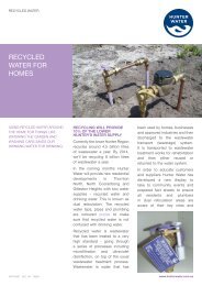
1.4 the lower hunter’s water supply<br />
hunter water’s role in water<br />
supply<br />
<strong>Hunter</strong> <strong>Water</strong> is responsible for supplying<br />
the Lower <strong>Hunter</strong> community with a<br />
reliable and healthy supply of water. This<br />
includes urban residents, the commercial<br />
sector and industry in the Newcastle,<br />
Lake Macquarie, Maitland, Cessnock and<br />
Port Stephens local government areas.<br />
Rural communities generally manage their<br />
own water supply by collecting rainwater<br />
in tanks, pumping from groundwater<br />
bores, or pumping from local creeks and<br />
rivers. The water supplies of some towns<br />
are managed by their local council.<br />
Dungog Shire Council, for instance,<br />
purchases bulk drinking water from <strong>Hunter</strong><br />
<strong>Water</strong> and then manages the delivery of<br />
this water to its customers, who pay for a<br />
reticulated water supply.<br />
<strong>Hunter</strong> <strong>Water</strong> operates five water<br />
treatment plants (WTPs), 4,270km of<br />
pipes, 77 reservoirs and 74 pump<br />
stations to supply water to homes,shops,<br />
factories, schools and hospitals. A<br />
strategic control centre provides 24hr<br />
monitoring of system performance.<br />
Where are our water SOURCES ?<br />
Chichester Dam<br />
Chichester Dam is the oldest<br />
operational dam in the <strong>Hunter</strong> and was<br />
completed in 1926. It was constructed<br />
on the Chichester River below the<br />
junction of the Wangat and Chichester<br />
Rivers. The catchment covers an area<br />
of 197km2 and includes extensive<br />
forests and high mountains. The<br />
catchment area is relatively unaffected<br />
by pollution caused by human activities.<br />
The dam was constructed using<br />
hundreds of interlocking units of<br />
concrete. Once one block was finished,<br />
the framework was raised ready for<br />
the next, until its final height of 40<br />
metres was reached. The dam can hold<br />
21,500 megalitres of water.<br />
Grahamstown Dam<br />
Grahamstown Dam has been operating<br />
since 1960 and is the Lower <strong>Hunter</strong>’s<br />
major urban water supply. It is an off<br />
river storage with water supplied from<br />
both its own catchment through runoff<br />
and by pumping fresh water across<br />
from the Williams River along the<br />
Balickera Canal. It is the largest water<br />
storage facility in <strong>Hunter</strong> <strong>Water</strong>’s area of<br />
operations and can hold 152,000<br />
megalitres of water.<br />
Tomago Sandbeds<br />
Tomago is a local Aboriginal name<br />
for ‘sweet water’. Since 1939 the<br />
Tomago Sandbeds has supplied water<br />
to the Lower <strong>Hunter</strong>.<br />
The sandbeds retain water, which seeps<br />
through the sand, allowing it to<br />
accumulate in the sand as a layer of<br />
water known as an aquifer. The<br />
catchment area covers130km2 and can<br />
hold 60,000 megalitres of water.<br />
Tomaree Sandbeds<br />
The Tomaree Sandbeds consist of an<br />
unconfined aquifer about 15km2 in<br />
area and exceeds a depth of 6.0 metres<br />
in some places.<br />
The Tomaree Sandbeds<br />
are located between Nelson Bay,<br />
Shoal Bay, Fingal Bay and One Mile<br />
Beach. The sandbeds can hold 16,000<br />
megalitres of water. A pipeline was<br />
built by <strong>Hunter</strong> <strong>Water</strong> in 2002 from<br />
Tomago WTP to supplement supply<br />
from the Tomaree aquifier.<br />
HOW TO MEASURE WATER<br />
VOLUMES<br />
<strong>Hunter</strong> <strong>Water</strong>’s water sources are<br />
Chichester Dam, Grahamstown Dam,<br />
and the Tomago-Tomaree Sandbeds<br />
- all located in either the Williams River<br />
or Port Stephens catchments<br />
Management and protection of these<br />
catchments is vital to safeguard the<br />
quality and quantity of the water supply.<br />
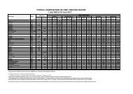
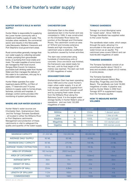
MEASUREMENT SYMBOL VOLUME EQUIVALENT<br />
Millilitre ml 20mls 1 dessert spoon<br />
Litre L 1000ml 1 litre of milk<br />
Kilolitre kl 1000L 1 very full bath<br />
Megalitres ML 1000kl 0.5 olympic pool<br />
Gigalitre GL 1000ML 500 olympic pools<br />
CHICHESTER DAM GRAHAMSTOWN DAM TOMAGO SANDBEDS TOMAREE SANDBEDS<br />
MAXIMUM CAPACITY 21,500 ML 152,000 ML 60,000 ML 16,000 ML<br />
AVERAGE DAILY SUPPLY 90 ML 60 ML 45 ML 7 ML<br />
MAXIMUM DAILY CAPACITY 90 ML 270 ML 140 ML 24 ML<br />
AVERAGE YEARLY EXTRACTION 33 GL 22 GL 16 GL 3 GL<br />
AREA OF STORAGE 180 hectares 2600 hectares n/a n/a<br />
AREA OF CATCHMENT 197km2 99km2 100km2 16km2<br />
AVERAGE DEPTH 35m 7m 20m 35m<br />
HEIGHT OF WALL 43m 10m n/a n/a<br />
LENGTH OF WALL 254m 4.8km n/a n/a<br />
LENGTH OF SPILLWAY 112m 160m n/a n/a<br />
COMMISSIONED 1925 1960 1939 1949<br />
<strong>Water</strong> kit . ssS . 001 . april 2010<br />
12