Water Kit - Hunter Water
Water Kit - Hunter Water
Water Kit - Hunter Water

You also want an ePaper? Increase the reach of your titles
YUMPU automatically turns print PDFs into web optimized ePapers that Google loves.
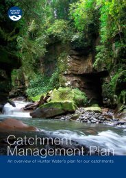
1.2 the importance of catchments<br />
Natural catchments direct runoff water to creeks, rivers, lakes, aquifiers and the ocean<br />
What is a catchment?<br />
A catchment is the area of land that<br />
supplies surface water to a common<br />
collection point - usually a creek, river,<br />
dam, ocean or aquifier. Typically,<br />
catchments are bordered by high<br />
points like hills or ridges that direct the<br />
flow of water.<br />
Catchments can vary in scale from<br />
the suburb you live in through to entire<br />
regions covering thousands of<br />
square kilometres. Many smaller<br />
catchments can be located within one<br />
large catchment.<br />
Catchments may be completely<br />
natural, or a combination of bushland,<br />
agricultural, industrial and urban areas.<br />
Typical coastal urban catchment land use zones<br />
The types of land use and surfaces<br />
found in a catchment will have a major<br />
effect on the quality and quantity of<br />
water found in the catchment zone.<br />
The quality of our fresh water supplies<br />
depends on the health of our catchments.<br />
HUNTER WATER’S AREA OF<br />
OPERATIONS<br />
<strong>Hunter</strong> <strong>Water</strong> provides water and<br />
wastewater services to towns and cities<br />
across the Lower <strong>Hunter</strong>, Lake Macquarie<br />
and Port Stephens catchments. This area<br />
of operations includes the five local<br />
government areas of Newcastle, Lake<br />
Macquarie, Port Stephens, Maitland<br />
and Cessnock.<br />
<strong>Hunter</strong> <strong>Water</strong>’s collection, storage and<br />
treatment of water is centred around<br />
the Williams River and adjacent Port<br />
Stephens catchments. The three main<br />
water storages are Chichester Dam,<br />
Grahamstown Dam and the Tomago<br />
Sandbeds.<br />
Chichester Dam is located north of<br />
Dungog. The catchment for Chicester<br />
Dam is within the Barrington Tops<br />
National Park and is a declared<br />
wilderness area. It is one of the most<br />
pristine catchments in Australia, with<br />
large areas unaffected by human<br />
activity. This is reflected in the quality<br />
of the water drawn from the dam.<br />
<strong>Water</strong> released from Chichester Dam<br />
flows into the Chichester River and the<br />
Williams River. The Williams River<br />
catchment is relatively undeveloped<br />
but supports a range of activities and<br />
land uses including agriculture,<br />
residential and urban developments,<br />
recreation and tourism.<br />
Further downstream, near Seaham,<br />
water from the Williams River can be<br />
transferred to Grahamstown Dam via the<br />
Balickera Canal. The Williams River<br />
Grahamstown Dam system is an<br />
important component of the Lower<br />
<strong>Hunter</strong>’s water supply.<br />
Grahamstown Dam is the region’s major<br />
urban water supply. It is an off-river<br />
storage with water supplied from its own<br />
catchment and the Williams River.<br />
The third source is underground water<br />
from the Tomago Sandbeds in the<br />
Port Stephens catchment. <strong>Water</strong> from<br />
the sandbeds is extracted by pumps<br />
and sent for treatment at the<br />
Grahamstown/Tomago <strong>Water</strong> Treatment<br />
Plant. Smaller treatment plants at Lemon<br />
Tree Passage, Glovers Hill and Anna Bay<br />
extract water from nearby aquifiers.<br />
The first map shows <strong>Hunter</strong> <strong>Water</strong>’s<br />
area of operations. While the Williams<br />
River catchment is not part of <strong>Hunter</strong><br />
<strong>Water</strong>’s area of operations in terms of its<br />
service to customers, it is of great<br />
importance due to the location of<br />
Chichester Dam.<br />
The following three maps on the<br />
opposite page show the Port Stephens,<br />
<strong>Hunter</strong> and Lake Macquarie<br />
catchments. The dashed lines in the top<br />
and middle maps show the boundary of<br />
<strong>Hunter</strong> <strong>Water</strong>’s area of operations.<br />
<strong>Water</strong> kit . ssS . 001 . april 2010<br />
4