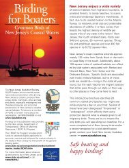
Grassland Bird Survey Protocol - New Jersey Audubon Society
Grassland Bird Survey Protocol - New Jersey Audubon Society
Grassland Bird Survey Protocol - New Jersey Audubon Society

You also want an ePaper? Increase the reach of your titles
YUMPU automatically turns print PDFs into web optimized ePapers that Google loves.
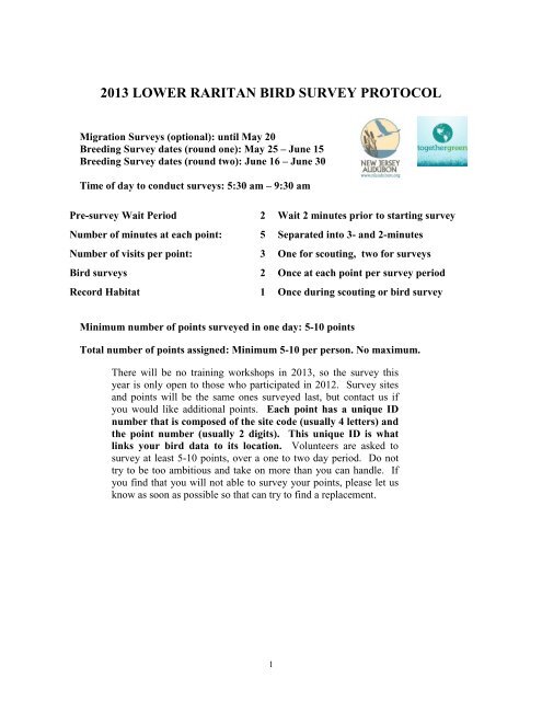
2013 LOWER RARITAN BIRD SURVEY PROTOCOL<br />
Migration <strong>Survey</strong>s (optional): until May 20<br />
Breeding <strong>Survey</strong> dates (round one): May 25 – June 15<br />
Breeding <strong>Survey</strong> dates (round two): June 16 – June 30<br />
Time of day to conduct surveys: 5:30 am – 9:30 am<br />
Pre-survey Wait Period 2 Wait 2 minutes prior to starting survey<br />
Number of minutes at each point: 5 Separated into 3- and 2-minutes<br />
Number of visits per point: 3 One for scouting, two for surveys<br />
<strong>Bird</strong> surveys 2 Once at each point per survey period<br />
Record Habitat 1 Once during scouting or bird survey<br />
Minimum number of points surveyed in one day: 5-10 points<br />
Total number of points assigned: Minimum 5-10 per person. No maximum.<br />
There will be no training workshops in 2013, so the survey this<br />
year is only open to those who participated in 2012. <strong>Survey</strong> sites<br />
and points will be the same ones surveyed last, but contact us if<br />
you would like additional points. Each point has a unique ID<br />
number that is composed of the site code (usually 4 letters) and<br />
the point number (usually 2 digits). This unique ID is what<br />
links your bird data to its location. Volunteers are asked to<br />
survey at least 5-10 points, over a one to two day period. Do not<br />
try to be too ambitious and take on more than you can handle. If<br />
you find that you will not able to survey your points, please let us<br />
know as soon as possible so that can try to find a replacement.<br />
1
2013 Lower Raritan bird survey<br />
Developed by Nellie Tsipoura and Mike Allen, <strong>New</strong> <strong>Jersey</strong> <strong>Audubon</strong> <strong>Society</strong><br />
Introduction<br />
The Raritan River is <strong>New</strong> <strong>Jersey</strong>’s largest river and is located entirely within our state’s<br />
borders. Including the watershed, the Raritan River Basin encompasses more than 1,100<br />
square miles (262,941 acres). Its waters are used for drinking, recreation, transportation<br />
and industry. Despite the environmental pressure to which they have been subjected, the<br />
Raritan River and Raritan Bay Estuary provide important wildlife habitats. From wetland<br />
and estuarine habitats that support osprey, night herons and black skimmers, riparian<br />
corridors that support nesting bald eagles, to upland grasslands sustaining grasshopper<br />
sparrows and bobolinks, thousands of acres within the watershed provide habitat critical<br />
to the continued survival of a diverse array of threatened and endangered species that is<br />
unrivaled in <strong>New</strong> <strong>Jersey</strong>. Threats to this system include extreme pressure from<br />
commercial and residential developments. In addition, industrial development has<br />
resulted in contamination of parts of the river and associated wetlands for decades.<br />
However, large sprawling industrial complexes also include some of the last remaining<br />
undeveloped habitats in this heavily populated watershed.<br />
<strong>New</strong> <strong>Jersey</strong> <strong>Audubon</strong> was been involved in surveys of urban habitats for birds for the<br />
past 30 years. Richard Kane, former Vice-president of Conservation, began conducting<br />
surveys and reporting on the Meadowland's avifauna in 1975. In 1991 Rich Kane headed<br />
up a team of NJAS staff that conducted the first year-long inventory of the Arthur Kill<br />
and Raritan. Much of what we currently know about the seasonal occurrences of avian<br />
species in the urban <strong>New</strong> <strong>Jersey</strong> wetlands is based on this work. More recently, the<br />
NJAS’s Research and Monitoring Department undertook and completed a two-year,<br />
systematic study of avian abundance and distribution in the Meadowlands 2004-2006),an<br />
avian study in the Gateway National Recreation Area (2006-2007), and a survey of the<br />
Lower Raritan (2009).<br />
Though this citizen science project we will continue and expand the 2009 surveys in<br />
Lower Raritan River to provide baseline information on bird use in the area. Results of<br />
this project will help set site acquisition priorities, and direct management and restoration<br />
activities related to reducing fragmentation and improving habitats for wildlife.<br />
Reporting Time<br />
All volunteer hours spent performing Lower Raritan bird surveys must be recorded on the<br />
provided timesheet. The project name is Lower Raritan <strong>Bird</strong> <strong>Survey</strong>s. In addition to the<br />
project name please record the Site Code, especially if you are working on more than one<br />
site. Make sure that all information is filled in every time you go into the field to work<br />
on this project. This includes scouting, habitat assessments, bird surveys, data entry, etc.<br />
2
Also be sure to record the miles traveled during each survey. NJAS must provide this<br />
timesheet to our funding partners. It is essential that this form be completed and returned<br />
to NJAS with your data sheets at the end of the field season. Thank you.<br />
Scouting<br />
Prior to the first bird survey, every point in each site needs to be scouted to determine<br />
suitability and accessibility. This initial visit must take place at any time before the<br />
surveys.<br />
Record habitat characteristics and dominant plant species at each point during this initial<br />
visit. Recording habitat is not meant to bog you down, it is a quick assessment of the<br />
dominant vegetative species, the habitat structure and habitat type. It should only take<br />
20 to 30 seconds at each point (see habitat protocol for further details).<br />
If a point is inaccessible, the point may be moved to a nearby location. To move a point,<br />
choose a location with suitable habitat on your route map that is at least 1000 feet or 300<br />
meters (straight distance) from any other point. Points should be relocated to the nearest<br />
suitable area of the same habitat type as the original point (forest, shrub scrub, open<br />
field, wetland.) When you find the new point location, draw an arrow on the route map<br />
from the old point location to the new one and indicate why it was moved (developed,<br />
inaccessible, etc). Make sure to mark the new location on the route map or the aerial<br />
map and record the GPS coordinates and the units (UTM, decimal degrees, etc.). If<br />
there are no other suitable locations that meet the criteria to move a point, then mark it<br />
on the map with an X and indicate why it was not surveyed (developed, inaccessible,<br />
etc.).<br />
PLEASE LET US KNOW (michael.allen@njaudubon.org) about any points that you<br />
move. If the area around the original point has been developed, please let us know<br />
immediately.<br />
<strong>Bird</strong> <strong>Survey</strong>s<br />
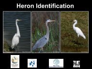
Make sure you are familiar with the songs of species likely to be seen during your<br />
surveys, and the points on identification. Some species are rather difficult to see through<br />
the vegetation or do not allow close approach for visual identification. We provided CDs<br />
of songs to all participants in the 2012 training workshops, and you are encouraged to<br />
keep practicing. We recommend you use a good field guide for visual identification.<br />
Each volunteer will be responsible for a minimum of 5-10 points. Each point is a predetermined<br />
location from which the observer conducts a survey.<br />
<strong>Survey</strong>s should not be conducted during rain. <strong>Survey</strong>s should also not be conducted<br />
during high winds (greater than 12mph {Beaufort 3}, which is enough to constantly<br />
move leaves or twigs and to extend a light flag.) <strong>Survey</strong>s will take place a half hour<br />
before to three hours after sunrise (approximately between 5:30 am and 9:00 am),<br />
during the breeding season. You will survey each point twice during the breeding<br />
3
season: once between May 25 th and June 15 th , and once between June 16 th and June 30 th .<br />
Once the observer arrives at the survey point wait 2 minutes before beginning the count.<br />
This enables the observer to prepare for the count and allows the birds to calm down and<br />
return to normal activity. During the survey the observer stands at the point for 5 minutes<br />
and records on the data sheet all grassland bird species seen or heard. This 5-minute<br />
period is divided into two periods; a 3- and a 2-minute period. The observer records the<br />
species and number of birds seen or heard during the first 3 minutes separately from<br />
those encountered during the next 2 minutes. Record all birds as less than 100 meters or<br />
greater than 100 meters away from the survey point on the data sheet. Do not count<br />
longer than five minutes. Do not exceed the 5-minute time limit because you are sure a<br />
certain "good bird" is there and not calling -- it will probably be recorded some other<br />
year, and valid negative data are as important as positive data in this survey. Species<br />
recorded that are not found on the form should be added at the bottom. If you observe<br />
any birds before or after the 5-minute survey, write it down in the margin or blank<br />
spaces on the bottom of the datasheet with a “before” or “after” next to it.<br />
One and only one observer should conduct the count. Counting should be done from<br />
outside the car from a stationary point. Absolutely no method of coaxing birds should be<br />
used during the 5-minute survey period. This means no "pishing", tape playbacks or any<br />
other method of enticing a bird to sing or call or make itself visible. It is crucial that all<br />
surveys be done consistently. Target birds observed between stops should not be counted,<br />
but may be noted in the margin of the route map with a line indicating the location of the<br />
species. Such birds are of interest, but do not spend extra time pursuing them, as it is<br />
important to finish within the time limit; bird activity changes drastically after this time.<br />
Be sure you record the survey site code, survey point number, observer,<br />
recorder (if applicable), date, start time and weather conditions on every<br />
datasheet.<br />
Each survey will be undertaken singly or by two people. We prefer single observers<br />
because we do not want the volunteer’s ability to concentrate on the birds to be<br />
compromised by the presence of another person. However, if you want to undertake the<br />
surveys with your birding partner, please take all precautions to avoid being distracted.<br />
Remember, only one person should be the primary observer. The second person can act<br />
as the recorder in this situation. If there are two observers, the primary observer says<br />
what she/he sees or hears to the recorder in a quiet voice and the recorder repeats back<br />
what she/he heard as the data are recorded. Only the birds seen and heard by the primary<br />
observer get recorded on the forms. If the recorder sees or hears a target species before<br />
or after the 5-minute survey, write it down in the margin or blank spaces on the bottom<br />
of the datasheet with a statement that this is a recorder observation.<br />
**Note on Counting the Same <strong>Bird</strong>: The same bird seen/heard in the 3-<br />
minute portion of the survey, then seen/heard again in the 2-minute<br />
portion is ONLY recorded in the 3-minute period as this is definitely a<br />
single individual. If you are sure that a bird observed in the 2-minute<br />
period is different from the one observed in the 3-minute period, by all<br />
4
means record it as a different individual in the 2-minute time slot.<br />
Noting on the data sheet that you were sure two different birds were<br />
observed is good to do.<br />
In all situations, avoid biasing the data by disturbing the birds. Walk out of your<br />
car quietly, approach the survey point cautiously, avoid unnecessary movements and try<br />
to blend in as much as possible.<br />
The method by which the bird was observed can be recorded as S (seen), H (heard), or<br />
SH (both seen and heard). Make sure you record flyovers (birds flying over, not through<br />
habitat).<br />
If females or juveniles are seen please note that information. Unless otherwise noted, we<br />
will assume that all detections are of singing males.<br />
Habitat <strong>Survey</strong>s<br />
At each point please describe general habitat characteristics of the area. Appendix I.<br />
(below) is a listing of the broad habitat categories. You can use the codes and record in<br />
the front of your data sheet, or circle the categories in the back of the data sheet.<br />
Circle the habitat class (upland or wetland) and habitat type (Urban; Barren land;<br />
Agricultural; Natural grassland; Scrub/shrub; Forest; Open water; Mudflat; Other). Feel<br />
free to add any other information on habitat in the comments section.<br />
Data Entry<br />
All observers will have access to NJAS’s online data entry website. Contact Nellie<br />
Tsipoura or Mike Allen for more instructions on how to use the data entry system.<br />
The system may not be set up yet. Go to<br />
http://www.njaudubon.org/Raritan2013/Login.aspx. At the bottom of the page you can<br />
click on Enter Data. This will send you to a new page. Click on the link that allows you<br />
to Enter Lower Raritan survey data. At the bottom of the page click Create a <strong>New</strong><br />
Account. Enter a User ID for yourself. Enter a password (at least 5 characters) and<br />
confirm that password. Enter your name, phone number and email address in the<br />
appropriate box. Nellie Tsipoura will provide Site Password. A page will open that asks<br />
you for the new User ID and password. Type them in, hit enter and you should be<br />
relocated to the data entry page. If you have any technical difficulties with this please let<br />
me know immediately so we can correct the problem.<br />
5
Once you have entered all of your data mail your hard copies to:<br />
Nellie Tsipoura<br />
<strong>New</strong> <strong>Jersey</strong> <strong>Audubon</strong> <strong>Society</strong><br />
Scherman-Hoffman Wildlife Sanctuary<br />
11 Hardscrabble Road<br />
P.O. Box 693<br />
Bernardsville, NJ 07924<br />
Thank you for your assistance and good luck with all of your surveys.<br />
PLEASE MAIL ALL DATA SHEETS BY August 1, 2013<br />
6
Appendix I.<br />
Weather conditions (from Breeding <strong>Bird</strong> <strong>Survey</strong>)<br />
Beaufort<br />
Wind Speed in<br />
Scale miles per hr. Indicators of Wind Speed<br />
0 Less than 1 Smoke rises vertically<br />
1 1 to 3 Wind direction shown by smoke drift<br />
2 4 to 7 Wind felt on face; leaves rustle<br />
3 8 to 12 Leaves, small twigs in constant motion;<br />
light flag extended<br />
4 13 to 18 Raises dust and loose paper; small<br />
branches are moved<br />
5 9 to 24 Small trees in leaf sway; crested<br />
wavelets on inland waters<br />
SKY CONDITION CODES:<br />
0 Clear or a few clouds<br />
1 Partly cloudy (scattered) or variable sky<br />
2 Cloudy (broken) or overcast<br />
4 Fog or smoke<br />
5 Drizzle<br />
7 Snow<br />
8 Showers<br />
Appendix II<br />
Equipment Checklist<br />
Clipboard Pencils<br />
Forms<br />
<strong>Bird</strong> count datasheet<br />
Habitat Category Form<br />
Route map<br />
Binoculars<br />
Watch with second hand (or timer)<br />
Thermometer (optional)<br />
7
Appendix III – 2012 Lower Raritan <strong>Survey</strong> Points<br />
8