newcastle ramblers bushwalking club newsletter - Confederation of ...
newcastle ramblers bushwalking club newsletter - Confederation of ...
newcastle ramblers bushwalking club newsletter - Confederation of ...

You also want an ePaper? Increase the reach of your titles
YUMPU automatically turns print PDFs into web optimized ePapers that Google loves.
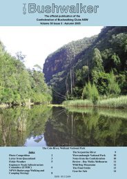
NEWCASTLE<br />
RAMBLERS<br />
BUSHWALKING CLUB<br />
NEWSLETTER<br />
JUNE 2010<br />
Yengo Traverse Backpack April 2010<br />
Mailles Ridge April 2010<br />
Overnight Backpack to<br />
Teddy’s Hut & the February 2010<br />
Chimneys<br />
Wingen Maid and Rocky Downfall<br />
Mountain April/May 2010<br />
Yengo Traverse Backpack<br />
2nd – 8th April 2010<br />
Leader: Peter Rye<br />
Drop Off walkers: David Morrison, Ken Thompson &<br />
Pauline Garry<br />
7 Day walkers: Robyn Rye, Royce Hirning, Lois Simpson,<br />
Stephen Ryan, Tony Winton & Doug Curry<br />
Pick up Crew: Carol Bastian, John Sharples & Bob Clifton<br />
The Ascent <strong>of</strong> Mt Gower April/May 2010<br />
Walls <strong>of</strong> Jerusalem February 2010<br />
RAMBLERS PHOTO COMPETITION<br />
RESULTS for 2009<br />
Category: Hand <strong>of</strong> Man<br />
1. Lost Cause - Robyn Rye<br />
2. Mowing Day - Peter Rye<br />
3. Seat with a View - Ingrid Waeger<br />
Category: Landscape<br />
1. Lake Nuga Nuga - Carol Bastian<br />
2. Green - Karl Cwach<br />
3. Moonlight on Ghosties - Robyn Rye<br />
Category: Nature<br />
1. Storm Clouds at Dusk - Robyn Rye<br />
2. Magic - Bruce Derkenne<br />
3. Butterfly on Flowers - Glenn Bird<br />
Category: Spirit <strong>of</strong> Bushwalking<br />
1. On Top <strong>of</strong> Ol’ Lockleys - Bruce Derkenne<br />
2. Cold Morning Campfire - Robyn Rye<br />
3. Pantoney’s Crown - Greg Powell<br />
Gary Scully Memorial Trophy for Best Overall<br />
Photo: Storm Clouds at Dusk - Robyn Rye<br />
Photos can be viewed here:<br />
http://www.<strong>bushwalking</strong>.org.au/<strong>newcastle</strong><strong>ramblers</strong><br />
/PhotoComp2009/PhotoCompWinners2009.html<br />
Contributions to Editor:<br />
Caroline Hargreaves. Email: ctaibs@gmail.com<br />
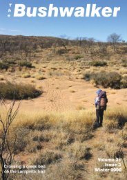
The drop <strong>of</strong>f walkers and the 7-day walkers<br />
Day I We started at the locked gate on Nowlands Track at<br />
10am 0n Friday 2nd and walked into Rileys paddock for lunch.<br />
We were surprised to find the creek almost dry, as there was<br />
quite a lot <strong>of</strong> water in it when we were there last. After lunch we<br />
followed the Tumbledown track south to the junction <strong>of</strong> Nowlands<br />
and Tumbledown creeks. We found a good campsite<br />
there after a climb down from the road.<br />
Day 2 Today was a hot and hard day as we headed<br />
towards Mount Calore. We were hoping to have reached<br />
the MacDonald River today, but it soon became obvious that<br />
we were not going to get that far. Tony started to suffer from<br />
cramps and the rest <strong>of</strong> us were getting very tired, so we were<br />
very relieved when Peter decided to cut the day short at 2pm<br />
camp in Yengo Creek.<br />
The creek is quite hard to access through the cliff lines but<br />
when we reached it there was a good sandy clear creek bed.<br />
It was not flowing but we managed to find good pools <strong>of</strong> water.<br />
Some explored the creek upstream for a km in the afternoon<br />
– the sandy bed made for good walking.<br />
PAGE
Day 3 The 3 weekend walkers decided to leave us this<br />
morning taking Tony with them. They were to follow Yengo<br />
creek upstream and access the Yengo / Calore road which<br />
leads back to the homestead.<br />
The remaining 6 reached Mount Calore at 12.30pm and<br />
after lunch at the dam followed a side creek into Calore<br />
creek then to the MacDonald. This part <strong>of</strong> the trip was<br />
extremely hard going and it took us all afternoon to reach<br />
the river arriving around 4pm.<br />
We were very weary but happy to see that the river had a<br />
reasonable flow <strong>of</strong> water in it – 2-3 inches – just enough to<br />
allow for good walking. Camp was set up on a bend 1 ½ k<br />
south <strong>of</strong> the Calore Creek junction.<br />
Day 4 Today was our first full day in the MacDonald and<br />
we left camp at 8.30am. We had 10-12 km to walk on firm<br />
sand so it was easy going through beautiful scenery and we<br />
reached our campsite on the Big Bend between 2.30 and<br />
3pm.<br />
Signs <strong>of</strong> civilization<br />
We camped where Peter had hidden our food and water<br />
drop. It was a very comfortable evening around the campfire<br />
with red wine and good tinned food – which was tastier than<br />
the dried food we had been eating all week. We had custard,<br />
peaches rice and chips – just to name some <strong>of</strong> the ‘goodies’.<br />
For good measure we also ate Tony’s stash – we didn’t think<br />
he would mind<br />
Day 7 Today was our last day and we left camp at 7.45am<br />
carrying the two water containers and the food barrel with<br />
us. We reached the Boree track by 9am and headed south<br />
stopping at Frying Pan rock for morning tea. Soon after we<br />
ran into Bob Clifton and John Sharples who were walking up<br />
from Audrey’s to meet us. The locked gate was reached by<br />
12.30 and 30 minutes later we were at Audrey’s studio.<br />
Carol, Bob and John put together a lovely lunch with hot cups<br />
<strong>of</strong> tea, which we had while sitting on the studio’s verandah.<br />
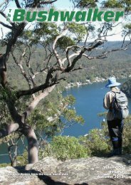
The beautiful MacDonald River<br />
Day 5 This was to be our last day walking in the<br />
MacDonald and there was a reluctance to hurry away from<br />
our campsite. So with Lois leading the way we did some cave<br />
exploring before leaving our camp at 9.30am.<br />
We had an easy 6km to travel today once again through<br />
beautiful country. We reached the junction <strong>of</strong> the Yengo and<br />
the MacDonald before lunch and were surprised to find the<br />
Yengo so dry that 4WDs had left wheel tracks on the creek<br />
bed. Last time we had been there the water was flowing<br />
quite well in both the Yengo and the MacDonald.<br />
We set up camp on the big sandbank and then some went<br />
exploring up the Yengo for some distance. That evening just<br />
before dark it started to rain and continued to rain for most <strong>of</strong><br />
the night. So we all sheltered under our large fly to eat and<br />
spend some time together.<br />
Day 6 We departed the Macdonald at 7.30am in the rain<br />
and started our wet and slippery climb up to the top <strong>of</strong> the<br />
Bala range. The rain stopped after we reached the top and<br />
further on the road, but it stayed cloudy all day. The road is<br />
good walking and our clothes had dried <strong>of</strong>f by the end <strong>of</strong> the<br />
day.<br />
PAGE <br />
At the Boree Track<br />
Many thanks to all the support<br />
crew at both ends.<br />
***********************
Leader: Peter Rye<br />
Mailles Ridge<br />
24-26 April 2010<br />
Walkers: Robyn Rye, Stephen Ryan, Kim Manhood,<br />
Sylvia Tait, Josh Green, Michelle Mackie &<br />
Mel Marriott<br />
We started from Sams Way at Mountain Lagoon at<br />
11am following a fire trail, which led to the start <strong>of</strong> the<br />
Mailles ridge foot track. The going was a bit slow as the<br />
track was sometimes a little hard to find and we <strong>of</strong>ten<br />
wandered onto old tracks and had to climb back to the<br />
top <strong>of</strong> the ridge to find the right way. It was getting quite<br />
late by the time we started the very steep decent from<br />
Meroo spot height.<br />
We reached the shelter shed at Meroo Plantation just<br />
as darkness was falling (after a slow and tiring climb<br />
down). Heavy rain started just as we were putting up our<br />
tents. There were other campers in the shed and luckily<br />
they had the fire going and did not mind us putting<br />
our billies on it for a warming cuppa. The rain continued<br />
all night and into the following morning.<br />
*******************<br />
Wingen Maid and<br />
Rocky Downfall Mountain<br />
30 April to 2 May 2010<br />
All up fifteen <strong>of</strong> us travelled to the ‘Washpools’ camping<br />
location <strong>of</strong> Towarri National Park to meet up at various<br />
times – some at Scone for morning tea and a walk to<br />
Burning Mountain for an early lunch.<br />
Burning Mountain is one <strong>of</strong> those places mostly bypassed<br />
on a driving trip, but really worth the effort <strong>of</strong><br />
1.5 hours return walking to see an interesting<br />
phenomena – the changed landscape resulting from a<br />
burning coal seam many metres below ground, which<br />
has been advancing 1metre per annum across the hillside<br />
for thousands <strong>of</strong> years.<br />
The other walkers had come in via the private property<br />
access road. Peter led a short walk the following morning<br />
to check out this route (we had been told it was no<br />
longer possible to access Meroo Plantation this way).<br />
NP have put a track around one <strong>of</strong> the properties that<br />
objected to walkers The other property owners he met<br />
are quite friendly.<br />
In the afternoon Peter led a short walk up the Colo,<br />
which had a good flow <strong>of</strong> water and some quicksand.<br />
We broke camp early the next morning so that we could<br />
climb the cliff before the day heated up and were back<br />
at the cars by 1.30pm after finding the track much easier<br />
to follow if we stayed on the ridgeline.<br />
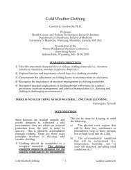
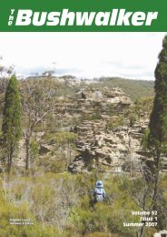
The fire affected landscape at<br />
Burning Mountain<br />
PAGE
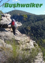
On setting up camp at the beautiful ‘Washpools’ we set<br />
<strong>of</strong>f up the eastern ridge behind the campsite to get a<br />
feel for the area and views <strong>of</strong> the Wingen Maid which<br />
we planned to climb the next day. The steep sandstone<br />
cliff lines <strong>of</strong> this prominent ridgeline in the distance were<br />
impressive. The rest <strong>of</strong> the group arrived after our return<br />
to camp and we settled in for a quite night around<br />
the camp fire.<br />
We retraced our route, with some delays in locating<br />
the pass through the cliff line, in much the same time<br />
frame.<br />
This weekend was also the first night <strong>of</strong> the extended<br />
trips <strong>of</strong> Kevin and Marise, and Lynne and Lindsay who<br />
separately were <strong>of</strong>f to points north in the Northern Territory<br />
and Queensland.<br />
On Saturday we drove from our campsite on Middlebrook<br />
to the next valley where we parked our vehicles<br />
next to Dry Creek at the base <strong>of</strong> the prominent and most<br />
likely looking ridge leading to the top <strong>of</strong> the ‘Maid’. We<br />
had checked in the day before with the property owner<br />
and had received plenty <strong>of</strong> directions to reach the top<br />
as well as some very interesting information <strong>of</strong> the geology<br />
and Aboriginal history <strong>of</strong> the area.<br />
We were able to follow a faint track which kept to the<br />
steep narrow ridge line through ‘Tiger Pear’ weed on<br />
the lower levels before it ascended through open forest<br />
and later rain forest in the shelter <strong>of</strong> the cliff lines.<br />
As we approached the cliff lines the track swung to the<br />
left (north) for several hundred metres before winding<br />
through a number <strong>of</strong> clefts and passes to the top – too<br />
easy.<br />
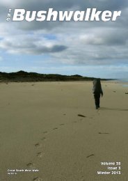
Top view from Wingen Maid north west along<br />
Dry Creek towards Mt Tinaroo<br />
Back in camp we enjoyed a beautiful evening and another<br />
campfire. We were joined by two young French<br />
girls traveling in Australia and later Neil showed us his<br />
tattoo.<br />
The next day (Sunday) we drove a short distance further<br />
up Middlebrook to the locked gate near a quarry<br />
and commenced our walk through farm land to the end<br />
<strong>of</strong> the track in undisturbed rainforest. We passed an<br />
abandoned farmhouse and several other reminders <strong>of</strong><br />
an earlier farming land use.<br />
After morning tea near the end <strong>of</strong> the track we climbed<br />
350m to the east on the Skyline Fire Trail to a saddle.<br />
At this point we had a choice <strong>of</strong> either walking (climbing)<br />
north up onto the Liverpool Range plateau some<br />
250 metres higher or walking south along the ridge to<br />
the prominent basalt outcrop named ‘Rocky Downfall<br />
Mountain’. We chose the latter and were delighted with<br />
the beautiful alpine vegetation along the way and the<br />
superb views in all directions.<br />
A rest stop along the Wingen Maid ridgeline<br />
We found ourselves in open forest grassland and headed<br />
east to the top <strong>of</strong> a prominent knoll for great views<br />
in all directions. The route to the lookout <strong>of</strong> the ‘Maid’<br />
& a trig station lay to the south along a narrow rocky<br />
ridgeline with patches <strong>of</strong> thick scrub here and there. We<br />
stuck to the eastern side <strong>of</strong> the ridge and reached the<br />
trig and our lunch spot soon after. All up the climb <strong>of</strong><br />
350m took about 2.5 hours over a distance <strong>of</strong> 3.5km.<br />
The Wingen Maid in the distance, and to the south east,<br />
looked small and we were certainly a lot higher than<br />
we had been the day before. There was a slight cool<br />
breeze blowing as we stopped for lunch – but what a<br />
superb location!<br />
We retraced our route and were back at the cars by<br />
3.30pm, giving us plenty <strong>of</strong> time to return to camp, pack<br />
dry tents, and head for home.<br />
Bob Clifton.<br />
*******************<br />
PAGE
Overnight Backpack to<br />
Teddy’s Hut & the Chimneys<br />
24/25 February 2010<br />
Whilst staying in Perisher for the week at the Shortland<br />
Ski Lodge, four <strong>of</strong> the Rambler’s group; Bob, Pauline,<br />
Malcolm, and David donned packs to walk to Teddy’s<br />
Hut, which has been beautifully restored since Bob’s<br />
last visit over six years ago.<br />
The hut, protected by nearby peaks Mt Leo, Brindle Hill,<br />
and Mt Terrible is located to the west <strong>of</strong> Smith Saddle at<br />
the head <strong>of</strong> Boggy Plain and the Thredbo River.<br />
Teddy’s Hut was constructed in 1948 as part <strong>of</strong> the<br />
high country grazing activities and after the mountain<br />
leases were resumed fell into almost complete ruin. In<br />
2005 the KHA and National Parks rebuilt the walls and<br />
chimney to restore the hut to something <strong>of</strong> its former<br />
beauty.<br />
The hut logbook records a visit by Peter and Robyn in<br />
2007 during a similar overnight walk. We had left the<br />
Lodge by 8.00am and in beautiful weather (still, clear,<br />
and sunny) were walking from Dead Horse Gap about<br />
an hour later along a track on the southern side <strong>of</strong> the<br />
infant Thredbo River. Our morning tea spot overlooked<br />
Boggy Plain which is a wide open frost plain surrounded<br />
by tree-covered hills, many <strong>of</strong> which have been affected<br />
by the fires <strong>of</strong> 2003.<br />
It is great to see the extent <strong>of</strong> re-growth occurring since<br />
the fires and the forested hills are well on the way to<br />
regaining their former beauty. On the positive side walking<br />
<strong>of</strong>f track is now much easier with little undergrowth<br />
to impede progress.<br />
We missed the location where the track crosses the<br />
river and ended up following bits and pieces <strong>of</strong> horse<br />
pads through swampy sections <strong>of</strong> the plain. Eventually<br />
we located a better track and climbed towards the<br />
Chimneys, a prominent rocky outcrop, resting for lunch<br />
in the saddle to the southwest.<br />
Our original plan was to climb up to the Chimneys, and<br />
follow the ridgeline to Smith Saddle. Rather than carry<br />
packs to the Chimneys we changed plans and climbed<br />
without packs (about 1.5 hours <strong>of</strong> return walking through<br />
fairly open snow gum forest).<br />
The views <strong>of</strong> course from the Chimneys were worth the<br />
effort extending in all directions from the Main Range<br />
to the Pilot.<br />
We returned to Boggy Plain and continued walking on<br />
the southern side <strong>of</strong> the River, sometimes on a good<br />
track and sometime on horse pads, which seemed to<br />
disappear in boggy sections.<br />
The walking was slow and tiring, and we were pleased<br />
to see Smith Saddle up in front. As we approached we<br />
startled a dozen magnificent brumbies grazing on the<br />
grassy flats.<br />
PAGE <br />
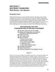
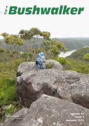
The Chimneys from our lunch spot<br />
in a saddle below<br />
We reached Teddy’s Hut about 5.00pm and soon had<br />
our tents erected & a nice little campfire lit to get some<br />
soup on. It was a lovely evening around the fire and as<br />
it cooled down stars filled a clear sky. We slept well.<br />
Our campsite near Teddy’s Hut<br />
The next morning we walked for an hour around the<br />
location enjoying its beauty and contemplated possible<br />
walks to Mt Leo, Paddy’s Rush, and Brindle Hill. A two<br />
night stay next time would allow this, and it would also<br />
be possible to return to Dead Horse Gap via this western<br />
ridgeline.<br />
We returned the way we had come, down Boggy Plain<br />
and reached Dead Horse Gap about 3.30pm, in time<br />
to meet the other Ramblers who had completed walks<br />
above Crackenback. A c<strong>of</strong>fee at the Village Bakery was<br />
followed by a refreshing swim at the Thredbo Swimming<br />
Centre. That evening we had dinner together at<br />
the local Italian Restaurant in Jindabyne.<br />
Overall a great couple <strong>of</strong> days to intersperse with the<br />
day walks completed during the week.<br />
Bob Clifton<br />
*******************
The Ascent <strong>of</strong> Mt Gower:<br />
One section at a time<br />
Recently a party <strong>of</strong> 26 Ramblers had a great holiday on<br />
beautiful Lord Howe Island. One <strong>of</strong> the many attractions <strong>of</strong><br />
this sub-tropical resort is the foreboding Mt Gower. At 875m<br />
above sea level, this is a sizable peak (technically a basalt<br />
remnant <strong>of</strong> a volcanic caldera) and is talked about as arguably<br />
one <strong>of</strong> the best climbs on the east coast. As group sizes<br />
were limited, we had planned for two groups to climb the<br />
mountain, the more experienced ones on Monday and the<br />
others on Wednesday.<br />
Now I don’t have any street cred as a mountain climber and I<br />
had a few misgivings firstly, whether I really wanted to climb<br />
it and secondly, whether I was up to the task. So I did the<br />
sensible thing: I asked around about what was involved and<br />
I prevaricated on coming to a decision.<br />
Hubby thought he was being very helpful, pointing out that<br />
the walk was only 8.5kms, and that while it was indeed 875m<br />
high, we had done many walks that had lots <strong>of</strong> uphills and<br />
down dales, which when added up were close to this, and<br />
that on the return journey it was in fact all downhill ! This all<br />
sounded very logical, but he hadn’t done the walk and did not<br />
really know what was entailed.<br />
Sure, but I was worried about the height thing — I am not the<br />
one in our house who climbs the extension ladder and paints<br />
the bargeboards and guttering!<br />
We went to see the tour lady, who said the guide (her son,<br />
Dean) would talk me through any sections that I was not comfortable<br />
with. So we paid our money and I was committed!<br />
Wednesday morning was overcast, but sunny with only a distant<br />
threat <strong>of</strong> rain. At 6.45am we were whisked <strong>of</strong>f by the Island<br />
shuttle bus to the trail head and met our muscular, very<br />
fit and unassuming guide, Dean. We signed the form taking<br />
full responsibility for our actions and collected our helmets.<br />
The initial stage <strong>of</strong> the walk was easy and at the end <strong>of</strong> the<br />
coastal strip Dean regrouped and told us about the forests<br />
that we’d be passing through. Then on the first steep section<br />
with thick ropes to aid the climb my heart began to race.<br />
At the top, we had a pause and my heart beat slowed — I<br />
was grateful for the stop. Dean gave another talk about the<br />
Island’s geology. I didn’t really listen I just ate a chocolate bar<br />
— I never eat chocolate but I thought ‘if ever I needed this, it<br />
is now’. Helmets on and we entered the breathtaking Lower<br />
Road, a half kilometre long narrow ledge with a clear and<br />
unimpeded 150m drop to the sea, but no worries there was a<br />
safety rope to cling to.<br />
So I kept listening in on briefings. The climb could only be<br />
done with an experienced, paid guide. Walkers were given<br />
safety helmets for one section. At one point there was a narrow<br />
ledge with a sheer drop to the sea but I was assured<br />
that the guide stood at this spot and would talk me through<br />
if I was out <strong>of</strong> my comfort zone. At many places there were<br />
safety ropes and in the steep parts there were climbing ropes<br />
to assist. The track was well defined, although there were no<br />
track markers. There were slippery sections and lots <strong>of</strong> tree<br />
roots, a good chance <strong>of</strong> rain, some exposed areas and the<br />
really steep knife-edge spurs had ropes to assist the climbers.<br />
Golly!<br />
After overnight rain, Monday came and the first group <strong>of</strong><br />
more experienced Ramblers set <strong>of</strong>f about 7am for their trip<br />
up the mountain. They came back much later than expected<br />
well after 6 pm, tired, muddy and exhausted. They variously<br />
said, ‘This was the hardest walk I have ever done’, there<br />
were ‘great views but we had a bit <strong>of</strong> rain and the track was<br />
quite slippery’ and ‘I slipped numerous times and came down<br />
many <strong>of</strong> the slopes on my bottom’ and ‘it was a great experience,<br />
but my knees are stuffed’ and ‘oh, where are my<br />
anti-inflammatory tablets’. The group was late because they<br />
were held up by ‘this 84 year old bloke who fell and needed<br />
assistance to descend and there was a teenage girl who<br />
could not cope with heights’. Another <strong>of</strong>f-putting aspect was<br />
that our dear ‘Marathon Man’, our veritable benchmark for fitness,<br />
was so knackered he skipped dinner and was not seen<br />
until the next day!<br />
Tuesday was fine and the forecast for Wednesday was almost<br />
favourable. The Monday warriors were vertical again,<br />
subdued but all cleaned up. Marathon Man had recovered<br />
and said it was the best walk he’d ever done and he was going<br />
to do it again on Wednesday! A friend who went with the<br />
Monday group felt it was within my capabilities and advised<br />
‘just take it one section at a time’.<br />
PAGE <br />
Another stop —and a muesli bar. Dean told us about the Island’s<br />
flora and fauna, and counselled that the next part was<br />
the toughest section <strong>of</strong> the ascent as we would climb steeply<br />
towards the saddle between Mt Lidgbird and Mt Gower. The<br />
track went through delightful rain forest dominated by Kentia<br />
palms and Banyan trees. Thick poly ropes were installed at<br />
the steeper sections so we were able to use our arm muscles<br />
to boost our leg power. The track led to a rest stop at pretty<br />
Erskine Creek where we were able to refill water bottles and,<br />
you guessed it — more chocolate.<br />
Dean explained that the track now climbed steeply to the<br />
saddle and up to a natural rock formation which had blocked<br />
the access <strong>of</strong> feral goats and pigs to the summit; consequently<br />
the flora <strong>of</strong> the summit was in pristine condition with<br />
many plant species that were endemic to the Island. Soon<br />
we reached a vantage point and could see straight over the<br />
nearby 777m Mt Lidgbird. In the distance were the coral
eefs and lagoon, the distant hills and Mt Eliza at the end <strong>of</strong><br />
the Island. While we laboured upwards, step after step, flocks<br />
<strong>of</strong> Providence Petrels were soaring effortlessly upon the air<br />
currents. But we were all enjoying ourselves, Marathon Man<br />
especially.<br />
More climbing and distant views <strong>of</strong> Balls Pyramid, perched<br />
like a geological ghost in the ocean. Then we came to a spot<br />
where Dean stood on the edge <strong>of</strong> the cliff and directed us up<br />
a long rocky section. I sensed this was ‘the bad bit’, kept my<br />
eyes on Dean and the way he was pointing and listened to his<br />
instructions — I did not look down or dare think ‘this won’t be<br />
easy coming down’. I concentrated only on the job at hand,<br />
finding hand and footholds. The rope really helped us to pull<br />
ourselves up this very steep exposed ridge.<br />
Then came the scary section where I couldn’t see the bottom<br />
<strong>of</strong> the rock face. I welded myself to the rope, searching for<br />
hand and foot holds and slowly descended until Dean’s head<br />
came into view and I was relieved when he said “put your foot<br />
there to the right’. But after a while, going down backwards<br />
on a long rope became rather fun and I found I was enjoying<br />
the descent where there were ropes. Of course there weren’t<br />
always ropes and the descent went on and on with me bracing<br />
on trees and securing my hand and footholds before taking<br />
each step. Towards the end my knees were telling me it<br />
had been a very steep descent and I was relieved when we<br />
reached Erskine Creek as I knew we were over the steepest<br />
parts. Then the time came for us to don helmets again for the<br />
Lower Road ledge.<br />
The last part <strong>of</strong> the walk seemed endless, but we managed to<br />
finish the walk about 5pm intact, unmuddied and undamaged<br />
and were pleased to be greeted by our fellow Ramblers who<br />
were out on a bird watching tour. They congratulated us on<br />
our successful climb. We were tired but had a great sense<br />
<strong>of</strong> accomplishment!<br />
I found myself really looking forward to the end and sitting in<br />
the bus. It had been a great experience and a credit to a really<br />
skilled guide who knew when to pause the group for a little talk<br />
and a muesli bar. And it was great testimony to the advice <strong>of</strong><br />
take it one section at a time.<br />
Grace Farley<br />
**************************<br />
Walls <strong>of</strong> Jerusalem and<br />
Freycinet National Park<br />
8-18 February 2010<br />
Once at the top, the wind-whipped shrubs actually gave us a<br />
sense <strong>of</strong> security as we couldn’t see how sheer the drop was<br />
to the ocean far, far below. As we approached the summit we<br />
regrouped in a little forest glade and Dean told us more about<br />
the Providence Petrels that burrow and breed only on Lord<br />
Howe Island They are an immensely curious species. He gave<br />
a loud whooping call and dozens <strong>of</strong> Petrels plummeted down<br />
through the trees to flop at our feet to see what was going on.<br />
I was not impressed when one dropped willy nilly and landed<br />
on my head! Some people actually held a bird in their hands<br />
but I was not so inclined!<br />
Upwards and onwards through the mossy shrubs, ferns, bush<br />
orchids, lichen and twisted roots to the summit and a rather<br />
small grassy clearing where we ate our lunch (sitting almost<br />
on top <strong>of</strong> one another) as we took in the superb vista <strong>of</strong> Lord<br />
Howe Island spread out in the ocean below. This was a very<br />
brief stop and Dean urged us to move on as if the descent<br />
could be difficult and he wanted to get started.<br />
Report by Bob Clifton<br />
As reported in the February Newsletter by Lynne eight<br />
Ramblers completed a very successful and enjoyable<br />
walking holiday to Tasmania in February 2010. Without going<br />
into all the detail I have posted a few photographs to paint<br />
the picture <strong>of</strong> this beautiful area.<br />
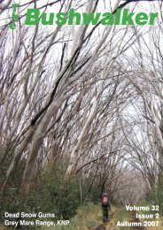
Day 1 was warm and sultry with a stiff 300m climb to<br />
Trappers Hut for morning tea, and then a steady 400m climb<br />
through Herod’s Gate to our campsite sheltered by ancient<br />
King Billy Pines beneath the Gate <strong>of</strong> Chain. The evening<br />
view <strong>of</strong> Mt Jerusalem was awesome.<br />
Going down was indeed all downhill but I felt apprehensive<br />
because we were up a heck <strong>of</strong> a long way. Fortunately Bruce<br />
preceded me and told me where he had found foot and handholds.<br />
The ropes were a godsend for the descent and I did<br />
learn some abseiling skills — thanks Andrew for your advice.<br />
PAGE
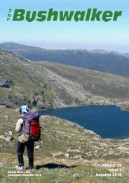
Day 2 included a circuit walk, in beautiful clear weather, to the top <strong>of</strong> Mt Jerusalem for views in all directions, lunch and a swim<br />
in Lake Tyre, a descent to Lake Thor, and return to camp via Zion Vale<br />
Day 3 dawned with atmosphere. We walked past Dickson Kingdom Hut, through Jaffa Vale, along the northern shore <strong>of</strong> Lake<br />
Ball and Lake Ball Hut, and to the northern end <strong>of</strong> Lake Adelaide for lunch in intermittent rain and in the company <strong>of</strong> heaps <strong>of</strong><br />
leaches. We found a protected campsite near Stretcher Lake and after a short evening walk in the mist were in bed by 6.00pm<br />
to achieve eleven hours sleep.<br />
Day 4 we returned to our cars, drove to Deloraine for lunch, and then onto Swansea for two nights.<br />
Day 5 involved a longish day walk past Mt Amos to the southern end <strong>of</strong> Wineglass Bay, returning via Hazards Beach and rocky<br />
headlands <strong>of</strong> Coles Bay. On Day 6 we headed to Maria Island which has been previously reported by Lynne.<br />
PAGE