Appendix B76 - Water use licence application forms ... - Zitholele.co.za
Appendix B76 - Water use licence application forms ... - Zitholele.co.za Appendix B76 - Water use licence application forms ... - Zitholele.co.za
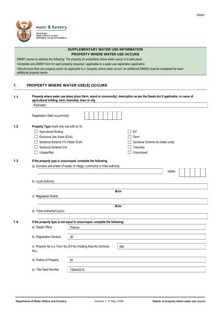
DW901 SUPPLEMENTARY WATER USE INFORMATION PROPERTY WHERE WATER USE OCCURS DW901 serves to address the following: The property (or properties) where water use(s) is to take place. •Complete one DW901 form for each property impacted / applicable to a water use registration application. •Should more than one property owner be applicable to a “property where water occurs” an additional DW902 must be completed for each additional property owner. 1. PROPERTY WHERE WATER USE(S) OCCURS 1.1 Property where water use takes place (farm, stand or community): description as per the Deeds Act if applicable, or name of agricultural holding, farm, township, town or city. Klipfontein Registration Date (ccyymmdd): 1.2 Property Type (mark only one with an X) Agricultural Holding Exclusive Use Areas (EUA) Sectional Scheme (To Obtain EUA) Sectional Scheme Unit Unspecified 1.3 If the property type is unsurveyed, complete the following: a) Surname and initials of leader of village, community or tribal authority Erf Farm Sectional Scheme (to obtain units) Township Unsurveyed Initials b) Local Authority c) Magisterial District &/or d) Tribal Authority/Council &/or 1.4 If the property type is not equal to unsurveyed, complete the following: a) Deeds Office Pretoria b) Registration Division JR c) Property No (i.e. Farm No./Erf No./Holding Area No./Scheme No.) 566 d) Portion of Property 59 e) Title Deed Number T5044/2010 Department of Water Affairs and Forestry (Version 1, 27 May 2009) Details of property where water use occurs
- Page 2 and 3: DW901 f) Surveyor-General Cadastral
DW901<br />
SUPPLEMENTARY WATER USE INFORMATION<br />
PROPERTY WHERE WATER USE OCCURS<br />
DW901 serves to address the following: The property (or properties) where water <strong>use</strong>(s) is to take place.<br />
•Complete one DW901 form for each property impacted / applicable to a water <strong>use</strong> registration <strong>application</strong>.<br />
•Should more than one property owner be applicable to a “property where water occurs” an additional DW902 must be <strong>co</strong>mpleted for each<br />
additional property owner.<br />
1. PROPERTY WHERE WATER USE(S) OCCURS<br />
1.1 Property where water <strong>use</strong> takes place (farm, stand or <strong>co</strong>mmunity): description as per the Deeds Act if applicable, or name of<br />
agricultural holding, farm, township, town or city.<br />
Klipfontein<br />
Registration Date (ccyymmdd):<br />
1.2 Property Type (mark only one with an X)<br />
Agricultural Holding<br />
Exclusive Use Areas (EUA)<br />
Sectional Scheme (To Obtain EUA)<br />
Sectional Scheme Unit<br />
Unspecified<br />
1.3 If the property type is unsurveyed, <strong>co</strong>mplete the following:<br />
a) Surname and initials of leader of village, <strong>co</strong>mmunity or tribal authority<br />
Erf<br />
Farm<br />
Sectional Scheme (to obtain units)<br />
Township<br />
Unsurveyed<br />
Initials<br />
b) Local Authority<br />
c) Magisterial District<br />
&/or<br />
d) Tribal Authority/Council<br />
&/or<br />
1.4 If the property type is not equal to unsurveyed, <strong>co</strong>mplete the following:<br />
a) Deeds Office Pretoria<br />
b) Registration Division JR<br />
c) Property No (i.e. Farm No./Erf No./Holding Area No./Scheme<br />
No.)<br />
566<br />
d) Portion of Property 59<br />
e) Title Deed Number T5044/2010<br />
Department of <strong>Water</strong> Affairs and Forestry (Version 1, 27 May 2009) Details of property where water <strong>use</strong> occurs
DW901<br />
f) Surveyor-General Cadastral Code<br />
1 2 3 4 5<br />
- - - -<br />
1. Refers to the Surveyor’s-General Office (T = Pretoria, F = Free State, C = Cape Town & N = Kwazulu-Natal)<br />
2. Major Code (Registration Division)<br />
3. Minor <strong>co</strong>de<br />
4. Property No (i.e. Farm No./Erf No./Holding Area No./Sheme No.)<br />
5. Portion Number<br />
Note: All fields “left padded with 0”<br />
1.5 Property Area Size<br />
0<br />
8<br />
Measure Unit: Hectares Square Meters Acres<br />
1.6 Ownership of the property (mark only one with an X)<br />
Property owned by applicant (100% Share value)<br />
Property owned by applicant (Share value less than 100%)<br />
Property leased by applicant<br />
The property is <strong>co</strong>mmunal land<br />
2. PROPERTY OWNER RELATIONSHIP<br />
Individual (Identity Number or<br />
Passport Number)<br />
Company, Business, Partnership or Community<br />
(Business Enterprise Registration Number)<br />
Property Owner Name<br />
Property Owner<br />
Document Number<br />
(Owner’s Title Deed<br />
Reference Number)<br />
Property Owner and Property<br />
Relationship Date<br />
2005/016701/07 Anglo Inyosi Coal T5044/2010 2010 100<br />
From:<br />
To:<br />
Owner Share Value %<br />
Department of <strong>Water</strong> Affairs and Forestry (Version 1, 27 May 2009) Page 2
DW901<br />
3. DECLARATION BY APPLICANT (or person that was granted power of attorney by the applicant)<br />
I declare that the property information given by me for registering this <strong>Water</strong> Use is true and <strong>co</strong>rrect.<br />
Signature Date (ccyymmdd) Thumbprint (only if requested)<br />
4. FOR OFFICE USE ONLY<br />
Received by:<br />
Surname<br />
Initials<br />
Position / Rank<br />
Signature<br />
Captured on NRWU database (ccyymmdd)<br />
Captured by:<br />
Surname<br />
Initials<br />
Signature<br />
Date stamp of receiving office<br />
Quality Assurance Executed by:<br />
Surname<br />
Initials<br />
Position / Rank<br />
Signature<br />
Date (ccyymmdd)<br />
Department of <strong>Water</strong> Affairs and Forestry (Version 1, 27 May 2009) Page 3


