Mountaineer - Arizona Mountaineering Club
Mountaineer - Arizona Mountaineering Club
Mountaineer - Arizona Mountaineering Club

You also want an ePaper? Increase the reach of your titles
YUMPU automatically turns print PDFs into web optimized ePapers that Google loves.
A Trip to the Boucher Shop (cont)<br />
This year’s participants ---a wiser Ted Parker; Saddle-ists:<br />
Val McNay, Jutta Ulrich, Rogil Schroeter and Dave<br />
Cameron; CO River toe-soakers: John Farrell and Bill Jay.<br />
Every time I visit this area it provides additional perspective<br />
on the courage and chutzpa of the early explorers like<br />
Boucher who found and developed these routes. Perhaps<br />
such individuals were simply more common then, but<br />
certainly amazing folks in amazing times nonetheless.<br />
As is characteristic of almost all our excursions, this trip<br />
also inspired interest in related future opportunities: like<br />
a 3 to 4 day Boucher – Hermits loop backpack and also<br />
dropping into the GC using the Dripping Springs trail<br />
connection at the top of Eremita Mesa. So, with a<br />
modicum of planning there’ll be more adventure afoot.<br />
Happy Trails!<br />
Dave Cameron<br />
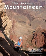
Looking upstream from the Yuma Point area: a<br />
muddy Colorado River and part of the Hermit Trail<br />
(lower RH corner).<br />
Update – Construction of Permanent Tom’s Thumb Trailhead<br />
The City of Scottsdale is beginning construction of the permanent Tom’s Thumb Trailhead. The permanent Tom’s<br />
Thumb Trailhead will be located southeast of the intersection of 128th Street and the Preserve boundary, and will<br />
be accessed via 128th Street. From now on the preferred access from the intersection of Pima and Happy Valley<br />
Road will be to take Happy Valley east to where it turns north and becomes 118th street. Turn east on Ranch<br />
Gate Road then south on 128th street. This route has been improved to the boundary of the McDowell Sonoran<br />
Preserve. The old access route through Troon will be gated and closed to public traffic prior to completion of the<br />
new Trailhead.<br />
You will see increasing construction activity throughout the winter climbing season. During the construction<br />
process, continue southbound on 128th Street to the T-intersection with El Paraiso and turn left/east and follow<br />
signage to the current Temporary parking areas near Sven Slab and underneath Morrell’s Wall. The City is willing<br />
to allow temporary access to the trail systems in the area as long as the hiker/biker/climber/horse rider activity<br />
does not interfere with Construction. Please respect this effort by the City to attempt to avoid closure during the<br />
entire construction process, which will continue through early summer of 2012. Inevitably there could be some<br />
short term closures due to construction needs, so please follow any official signage. We will also attempt to get<br />
the word out when we know sufficient information.<br />
The Preserve is owned by the City of Scottsdale and its primary purpose is to keep the natural habitat and geology<br />
in its native state. All usage is governed by the City of Scottsdale code and will be enforced. Once in the Preserve,<br />
please remember to follow all of the City of Scottsdale rules and regulations for the Preserve as indicated on the<br />
signage. These rules include no camping or overnight stays, opening at sunrise and closing at sunset, etc. Stay<br />
on the designated main trails, and only access crags on the official climber trails, most of which are marked by<br />
signage along the Tom’s Thumb Trail. Under no circumstances use the old access to Tom’s Thumb that enters near<br />
amcaz.org 16