Mountaineer - Arizona Mountaineering Club
Mountaineer - Arizona Mountaineering Club
Mountaineer - Arizona Mountaineering Club

You also want an ePaper? Increase the reach of your titles
YUMPU automatically turns print PDFs into web optimized ePapers that Google loves.
A Trip to the Boucher Shop<br />
Rogil’s 2011 Grand Canyon, Half-Fast Death March<br />
In response to rim-2-rim-2-rim exploits and similar (to her mind) irrationalities, Rogil established a complementary<br />
day hike that would employ South Rim of Grand Canyon trail(s) as in-out or loop trips. These excursions<br />
have featured most of the S rim trails, but non-main corridor routes dominate. This year’s nineteenth annual<br />
opportunity was no exception: we all accessed and hiked portions of the Boucher Trail on September the 24th.<br />
The trek started at the road’s-end, gated access to the Waldron trailhead, descended the Waldron Trail, and<br />
connected via pieces of the Hermit and Dripping Springs Trails to the Boucher Trail. From there most of us<br />
were in for the as-far-as-you-can-get-before-turnaroundtime<br />
effort. Rogil, Jutta, Val and I were happy to get to the<br />
saddle between Cocopa Point and Whites Butte, John and<br />
Bill ventured further to reach the Colorado River, while<br />
Ted (having been a player in last year’s epic escapade)<br />
opted for a somewhat less rigorous effort and turned back<br />
at Yuma Point.<br />
Off to a fairly early start – we were on trail at 05h30 with<br />
a few headlamps agleam to help negotiate the road to the<br />
Waldron trailhead per se. We all hiked together to this<br />
point, but afterward John and Bill pulled ahead as it was<br />
their announced intent to try and make it to the river. The<br />
weather cooperated – meeting the forecast’s propitious<br />
prediction for being a grand day to be hiking.<br />
From the gate and using the Waldron Trail this leg of the<br />
hike drops about 300 meters into Hermit Basin and the junction with the Hermit Trail. As we hiked toward the<br />
basin the sun gradually emerged. With sunrise, effort, and descent we warmed and shed layers accordingly.<br />
A short stint on the Hermit Trail took us nominally west to the junction with the Dripping Springs trail where we<br />
arrived just after 07h00. At the signed junction we found a posting indicating several slides along the Dripping<br />
Springs trail might offer some difficulty in passage. These proved no great challenge with only due diligence<br />
necessary in crossing the washed out areas. A somewhat<br />
undulating route, this part of the Dripping Springs trail traverses<br />
the head of the canyon formed by the upper part of<br />
Hermit Creek and offers the first ‘exposure’ to a bit of shelf<br />
walking. Total drop from the Waldron-Hermit trail junction<br />
to the turnoff onto the Boucher Trail is around 30 m.<br />
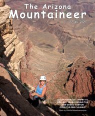
Ted pointing into Travertine Canyon from Yuma<br />
Point.<br />
Ted, Rogil, and Jutta carefully getting through one<br />
of the slides on the Dripping Springs Trail.<br />
The Dripping Springs portion of the hike going in took<br />
about ¾ hour. Before starting out on the trail of destination<br />
we took a short break and enjoyed a snack in the shade. It<br />
was a welcome stop. Then we were off toward Yuma Point,<br />
the headwall and descent through part of Travertine Canyon,<br />
and the to-become turnaround point of the Cocopa<br />
Point - Whites Butte saddle.<br />
The route out to Yuma Point is mostly east-facing with<br />
amcaz.org 13