WingX 2.0 User Manual - FAASafety.gov
WingX 2.0 User Manual - FAASafety.gov
WingX 2.0 User Manual - FAASafety.gov

Create successful ePaper yourself
Turn your PDF publications into a flip-book with our unique Google optimized e-Paper software.
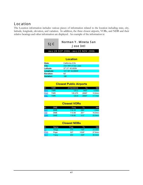
Location<br />
The Location information includes various pieces of information related to the location including state, city,<br />
latitude, longitude, elevation, and variation. In addition, the three closest airports, VORs, and NDB and their<br />
relative bearings and other information are displayed. An example of the information is:<br />
SJC<br />
Norman Y. Mineta San<br />
Jose Intl<br />
0901Z 28 SEP 2006 - 0901Z 23 NOV 2006<br />
Location<br />
State:<br />
California (CA)<br />
City:<br />
2nm NW of San Jose<br />
Latitude: 37' 21" 45.600N<br />
Longitude: 121' 55" 44.800W<br />
Elevation: 62'<br />
Variation:<br />
16E<br />
Closest Public Airports<br />
ID TWR ATIS/AWOS To NM<br />
RHV TWR 125.2 94° 5.5nm<br />
PAO TWR 135.275 289° 10.6nm<br />
SQL TWR 125.9 285° 17.7nm<br />
Closest VORs<br />
ID DME Freq To NM<br />
SJC DME 114.10 299° 1.0nm<br />
OSI DME 113.90 261° 16.9nm<br />
OAK DME 116.80 312° 25.9nm<br />
Closest NDBs<br />
ID Name Freq To NM<br />
LV Reiga 374 15° 23.0nm<br />
PDG Pajar 327 153° 27.6nm<br />
TCY Tracy 203 34° 30.4nm<br />
47