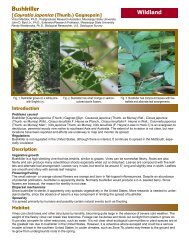
RATopic1_95 - Geosystems Research Institute - Mississippi State ...
RATopic1_95 - Geosystems Research Institute - Mississippi State ...
RATopic1_95 - Geosystems Research Institute - Mississippi State ...

You also want an ePaper? Increase the reach of your titles
YUMPU automatically turns print PDFs into web optimized ePapers that Google loves.
available as layers to advise volunteers and professionals in their surveys, to target rapid response efforts. Predicted distributions<br />
will be based on models developed research section, thus integrating research into the extension and outreach<br />
effort.<br />
Our database will be available for data entry to anyone<br />
willing to register as a user, providing contact<br />
information to clarify observations and track by<br />
whom data has been entered. A reward system for<br />
new finds or most locations for each year will be<br />
developed to encourage participants. Our data will<br />
be freely available to others interested in distribution<br />
data. We will develop generators in which users<br />
can select species of concern and download data in a<br />
specified format. Also, we will develop data exchange<br />
relationships with the USDA PLANTS database<br />
and the appropriate NBII ISIN and SAIN<br />
nodes. Lastly, we will contact the appropriate CAPS<br />
coordinator in each state if federal or regulated noxious<br />
weeds are found, so that the information can be<br />
entered into NAPIS.<br />
Our database currently holds 8786 records for 136<br />
species from 29 US states, with a backlog of several<br />
thousand records to be entered.<br />
Literature Cited<br />
MS Loess Plains<br />
MS Alluvial Plain<br />
Southeastern Plains<br />
Southern Coastal Plain<br />
Figure 3. Target geographic region for the Invasive Plant Atlas of<br />
the Mid-South (IPAMS). Shaded portions indicate initial focus of<br />
habitat modeling efforts.<br />
North American Weed Management Association (NAWMA). 2002. North American Invasive Plant Mapping Standards.<br />
Granby, CO. May 2002. 34pp.<br />
2009 USGS Annual Report 30 <strong>Mississippi</strong> <strong>State</strong> University’s <strong>Geosystems</strong> <strong>Research</strong> <strong>Institute</strong>