RATopic1_95 - Geosystems Research Institute - Mississippi State ...
RATopic1_95 - Geosystems Research Institute - Mississippi State ...
RATopic1_95 - Geosystems Research Institute - Mississippi State ...

You also want an ePaper? Increase the reach of your titles
YUMPU automatically turns print PDFs into web optimized ePapers that Google loves.
Task 4. Web-based Database of Invasive Plant Species Locations (IPAMS)<br />
PI: John Madsen<br />
Co-PI: Gary Ervin, Clifton Abbott, David Shaw, and John Byrd<br />
Collaborators: Randy Westbrooks, USGS NWRC, Annie Simpson, USGS National Headquarters (NBII), and Les Mehrhoff,<br />
University of Connecticut (IPANE)<br />
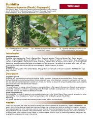
Figure 1. Cogongrass, Imperata cylindrica. Photo by<br />
Debbie McBride.<br />
An Update to the Invasive Plant Atlas of the MidSouth Project<br />
John D. Madsen and Gary N. Ervin<br />
Invasive weedy plants are a widespread problem throughout the<br />
United <strong>State</strong>s. Their growth is often widely dispersed, with little<br />
scientific ability to predict why they occur in a given location.<br />
In addition, historical human activities such as urbanization,<br />
agriculture, and forestry have a marked effect on the distribution<br />
and spread of invasives. This project will quantify relationships<br />
of weed distribution and spread with land use, then<br />
use that information directly in educating agriculture stakeholders,<br />
natural resources managers, and other interested parties<br />
on potential human-induced opportunities for invasive species<br />
spread. The Invasive Plant Atlas of the Mid-South (IPAMS) is<br />
an integrated research and extension project to develop an invasive<br />
plant program for the Mid-South states of Alabama, Arkansas,<br />
Louisiana, <strong>Mississippi</strong>, and Tennessee. <strong>Research</strong> activities<br />
include conducting systematic regional vegetation surveys to<br />
assess the distribution of key invasive plants, developing models<br />
for predicting the occurrence of target species based on land<br />
use and cover, and evaluating the relative effectiveness of professional<br />
versus volunteer surveys. For the research component of this project, we have surveyed over 470 points<br />
throughout the state of <strong>Mississippi</strong>, providing data on more than 800 plant species, including more than 70 not native to<br />
the region. Initial analyses of these data have demonstrated a strong correlation of land use/cover with the presence of<br />
exotic plant species, especially key invaders such as the grass Imperata cylindrica (cogongrass, Figure 1). Outreach and<br />
extension activities include developing training programs for volunteers to identify and report invasive species using<br />
IPAMS, developing an efficient Early Detection and Rapid Response (EDRR) system for invasive plants, developing<br />
best management information, and developing an online mapping system. To date, we have trained numerous individuals<br />
in identification of our target forty species. We are in the process of developing management information for these<br />
species. Our webpage (www.gri.msstate.edu/ipams) is operational, with over 8700 records of 136 species from 29<br />
states, entered and many more observations completed but not entered into the database.<br />
Introduction<br />
Invasive plants are a global problem battled at the local level, by individual landowners and consumers. The problem is<br />
dispersed across the landscape, and largely borne by individual landowners or resource agencies. Government agencies<br />
have neither the resources nor personnel to survey the entire landscape and manage all infestations of these problematic<br />
species, and the number of species is too large for a simple public awareness campaign.<br />
Our project is aimed at quantifying relationships of weed distribution and spread with land use, and then using that information<br />
directly in educating agriculture stakeholders, natural resources managers, informed citizen groups, and other<br />
interested parties on potential anthropogenically induced opportunities for invasive species spread.<br />
The long-term goal of the proposed work is the development of a regional invasive species database, similar to that developed<br />
for the Invasive Plant Atlas of New England (IPANE). The resulting internet portal, named the Invasive Plant<br />
Atlas of the Mid-South (IPAMS – www.gri.msstate.edu/ipams) provides information on the biology, ecology, distribution,<br />
and best management practices for forty of the most economically and ecologically significant invasive weeds in<br />
the mid-south.<br />
2009 USGS Annual Report 27 <strong>Mississippi</strong> <strong>State</strong> University’s <strong>Geosystems</strong> <strong>Research</strong> <strong>Institute</strong>