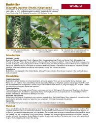
Task 4. Invasive Plant Atlas Figure 1. Japanese honeysuckle (Lonicera japonica) is one of the forty species included in the IPAMS training. Photo by Victor Maddox Figure 2. John Madsen training utility employees and contractors at an IPAMS workshop held with the <strong>Mississippi</strong> Vegetation Management Association at Lake Tiak O’Khata in November 2009. GRI Photo. 2009 USGS Annual Report 26 <strong>Mississippi</strong> <strong>State</strong> University’s <strong>Geosystems</strong> <strong>Research</strong> <strong>Institute</strong>
Task 4. Web-based Database of Invasive Plant Species Locations (IPAMS) PI: John Madsen Co-PI: Gary Ervin, Clifton Abbott, David Shaw, and John Byrd Collaborators: Randy Westbrooks, USGS NWRC, Annie Simpson, USGS National Headquarters (NBII), and Les Mehrhoff, University of Connecticut (IPANE) Figure 1. Cogongrass, Imperata cylindrica. Photo by Debbie McBride. An Update to the Invasive Plant Atlas of the MidSouth Project John D. Madsen and Gary N. Ervin Invasive weedy plants are a widespread problem throughout the United <strong>State</strong>s. Their growth is often widely dispersed, with little scientific ability to predict why they occur in a given location. In addition, historical human activities such as urbanization, agriculture, and forestry have a marked effect on the distribution and spread of invasives. This project will quantify relationships of weed distribution and spread with land use, then use that information directly in educating agriculture stakeholders, natural resources managers, and other interested parties on potential human-induced opportunities for invasive species spread. The Invasive Plant Atlas of the Mid-South (IPAMS) is an integrated research and extension project to develop an invasive plant program for the Mid-South states of Alabama, Arkansas, Louisiana, <strong>Mississippi</strong>, and Tennessee. <strong>Research</strong> activities include conducting systematic regional vegetation surveys to assess the distribution of key invasive plants, developing models for predicting the occurrence of target species based on land use and cover, and evaluating the relative effectiveness of professional versus volunteer surveys. For the research component of this project, we have surveyed over 470 points throughout the state of <strong>Mississippi</strong>, providing data on more than 800 plant species, including more than 70 not native to the region. Initial analyses of these data have demonstrated a strong correlation of land use/cover with the presence of exotic plant species, especially key invaders such as the grass Imperata cylindrica (cogongrass, Figure 1). Outreach and extension activities include developing training programs for volunteers to identify and report invasive species using IPAMS, developing an efficient Early Detection and Rapid Response (EDRR) system for invasive plants, developing best management information, and developing an online mapping system. To date, we have trained numerous individuals in identification of our target forty species. We are in the process of developing management information for these species. Our webpage (www.gri.msstate.edu/ipams) is operational, with over 8700 records of 136 species from 29 states, entered and many more observations completed but not entered into the database. Introduction Invasive plants are a global problem battled at the local level, by individual landowners and consumers. The problem is dispersed across the landscape, and largely borne by individual landowners or resource agencies. Government agencies have neither the resources nor personnel to survey the entire landscape and manage all infestations of these problematic species, and the number of species is too large for a simple public awareness campaign. Our project is aimed at quantifying relationships of weed distribution and spread with land use, and then using that information directly in educating agriculture stakeholders, natural resources managers, informed citizen groups, and other interested parties on potential anthropogenically induced opportunities for invasive species spread. The long-term goal of the proposed work is the development of a regional invasive species database, similar to that developed for the Invasive Plant Atlas of New England (IPANE). The resulting internet portal, named the Invasive Plant Atlas of the Mid-South (IPAMS – www.gri.msstate.edu/ipams) provides information on the biology, ecology, distribution, and best management practices for forty of the most economically and ecologically significant invasive weeds in the mid-south. 2009 USGS Annual Report 27 <strong>Mississippi</strong> <strong>State</strong> University’s <strong>Geosystems</strong> <strong>Research</strong> <strong>Institute</strong>