Download - Wrexham County Borough Council
Download - Wrexham County Borough Council Download - Wrexham County Borough Council
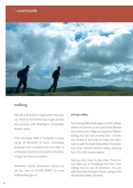
countryside walking Don’t let it all fly past in a green blur from your car. There’s a much better way to get up close and personal with Wrexham’s countryside. Shanks’s pony. There are many miles of footpaths in every corner of Wrexham. In every conceivable landscape from woodland and river valley to windswept moorland and heathery mountain. Just get out there and explore. Wrexham’s Tourist Information Centre can tell you how on 01978 292015 or email tic@wrexham.gov.uk ceiriog valley The Ceiriog Valley Walk begins at Chirk railway station and finishes at the foot of the Berwyn mountains in the village of Llanarmon Dyffryn Ceiriog. You can start at either end – or from any number of bus stops en route. You don’t have to walk the whole thing, either. It’s broken into seven themed sections taking anything from 30 to 90 minutes apiece. And you don’t have to stop there. There are five walks out of Pontfadog. Five from Glyn Ceiriog. And six out of Llanarmon. You can walk from Glyn Ceiriog to Pandy, taking in the disused Glyn Valley Tramway. 46
Ceiriog Valley And if you’re really keen, not to mention fit, you can tackle two big circular routes. The Ceiriog Trail at 23 miles and the Upper Ceiriog Trail at 14 miles. Designed for horse riders. But regularly conquered by serious walkers. Ceiriog Country Holidays 01691 718398 www.ceiriog.com maelor way The Maelor Way passes through three counties on its 24-mile journey from Grindley Brook to Bronygarth in the shadow of Chirk Castle. It uses a beguiling mix of footpaths, bridleways, quiet lanes and canal towpaths. You’ll see views of the Berwyn mountains and the Cheshire Plain. And pass through or near villages such as Bronington, Hanmer, Penley and Overton – which could provide a welcome pit stop. Not to mention a pint. Rather special in its own right, it also links no fewer than six long-distance paths. The Sandstone Trail, South Cheshire Way, Marches Way and Shropshire Way in the east. And Offa’s Dyke National Trail and the Ceiriog Valley Walk to the west. Who knows where you could end up? offa’s dyke path One of just 12 National Trails, this path runs a whopping 177 miles from Sedbury Cliffs near Chepstow to the coastal resort of Prestatyn. That’s the entire length of Wales. It’s named after and often follows the spectacular earthwork which King Offa of Mercia ordered to be built in the eighth century. It crosses the border between England and Wales more than 20 times. And it passes through three Areas of Outstanding Natural Beauty - including the Clwydian Range on Wrexham’s doorstep. We might be biased but we think our section contains the most impressive structure on the entire route. Thomas Telford’s Pontcysyllte Aqueduct, the longest and highest in Britain. www.nationaltrail.co.uk/offasdyke wat’s dyke way Wat’s Dyke is shorter and, we must confess, a lot less famous than Offa’s Dyke. But it’s altogether more mysterious. For a start, no one knows who Wat was. Some think he was a Mercian king. Others say he never existed and that Wat meant simply “wet” or “rough”. And for a long time, no one knew when the dyke was built. But carbon dating now indicates some time between the fifth and sixth centuries. What we do know for sure is that the 61-mile trail which follows the earthwork was 10 years in the planning. It enters Wrexham at Overton, crosses the River Dee at Erbistock, skirts the National Trust’s Erddig and takes in the grave of Elihu Yale in Wrexham town centre. Finally, via a deep valley, it emerges in Alyn Waters Country Park before passing into Flintshire. And at no point is it more than three miles from the famous dyke of Offa. Who, it seems, was a bit of a copycat. www.watsdykeway.org www.wrexham.gov.uk/countryside 47
- Page 1 and 2: year of culture edition the real wr
- Page 3 and 4: contents To make it easier for you
- Page 5 and 6: join the party We do like a party
- Page 7 and 8: Butchers’ market see you again ne
- Page 9 and 10: ig name brands Eagles Meadow occupi
- Page 11 and 12: mind your language Travel around Wr
- Page 13 and 14: don’t look down Take a deep breat
- Page 15 and 16: chirk castle Next time you’re cli
- Page 17 and 18: telford’s other aqueduct Just a f
- Page 19 and 20: open church network Wrexham’s chu
- Page 21 and 22: Clywedog Trail of industrial herita
- Page 23 and 24: Looking for somewhere FREE to visit
- Page 25 and 26: hold on to your hats Horse racing a
- Page 27 and 28: Excitingly, they can even work out
- Page 29 and 30: North Wales Regional Tennis Centre
- Page 32 and 33: it’s party time They call it a cr
- Page 34 and 35: what are you doing Wrexham is very
- Page 36 and 37: welsh choirs We don’t just sing w
- Page 38 and 39: Sharp Solar Centre science discover
- Page 40 and 41: nightlife Real Wrexham. Real buzz.
- Page 42 and 43: nightlife nightclubs We wouldn’t
- Page 44 and 45: countryside We have some pretty hea
- Page 48 and 49: countryside country parks There’s
- Page 50 and 51: countryside Acton Park Snowdrops at
- Page 52 and 53: countryside Bangor-on-Dee towns and
- Page 54: countryside Holt Bridge Overton Bri
- Page 57 and 58: Catrin Finch Centre feel the buzz L
- Page 59 and 60: Our sports venues have also seen a
- Page 61 and 62: see you soon Who said nothing good
- Page 63 and 64: Wrexham Tourist Information Centre
- Page 65: wrexham the big picture 65
- Page 68 and 69: wrexham the big town Key Toilets Pa
countryside<br />
walking<br />
Don’t let it all fly past in a green blur from your<br />
car. There’s a much better way to get up close<br />
and personal with <strong>Wrexham</strong>’s countryside.<br />
Shanks’s pony.<br />
There are many miles of footpaths in every<br />
corner of <strong>Wrexham</strong>. In every conceivable<br />
landscape from woodland and river valley to<br />
windswept moorland and heathery mountain.<br />
Just get out there and explore.<br />
<strong>Wrexham</strong>’s Tourist Information Centre can<br />
tell you how on 01978 292015 or email<br />
tic@wrexham.gov.uk<br />
ceiriog valley<br />
The Ceiriog Valley Walk begins at Chirk railway<br />
station and finishes at the foot of the Berwyn<br />
mountains in the village of Llanarmon Dyffryn<br />
Ceiriog. You can start at either end – or from<br />
any number of bus stops en route. You don’t<br />
have to walk the whole thing, either. It’s broken<br />
into seven themed sections taking anything<br />
from 30 to 90 minutes apiece.<br />
And you don’t have to stop there. There are<br />
five walks out of Pontfadog. Five from Glyn<br />
Ceiriog. And six out of Llanarmon. You can<br />
walk from Glyn Ceiriog to Pandy, taking in the<br />
disused Glyn Valley Tramway.<br />
46


