
You also want an ePaper? Increase the reach of your titles
YUMPU automatically turns print PDFs into web optimized ePapers that Google loves.
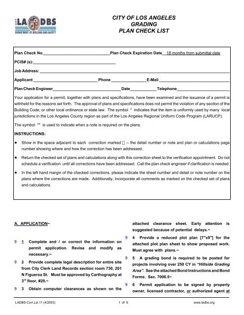
CITY OF LOS ANGELES<br />
<strong>GRADING</strong><br />
<strong>PLAN</strong> <strong>CHECK</strong> <strong>LIST</strong><br />
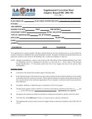
Plan Check No.______________________________Plan Check Expiration Date__18 months from submittal date<br />
PCIS# (s):_____________________________________<br />
Job Address: ______________________________________________________________________________________<br />
Applicant _____________________________ Phone ________________E-Mail ________________________________<br />
Plan Check Engineer_______________________________ Date____________ Telephone________________________<br />
Your application for a permit, together with plans and specifications, have been examined and the issuance of a permit is<br />
withheld for the reasons set forth. The approval of plans and specifications does not permit the violation of any section of the<br />
Building Code, or other local ordinance or state law. The symbol * indicates that the item is uniformly used by many local<br />
jurisdictions in the Los Angeles County region as part of the Los Angeles Regional Uniform Code Program (LARUCP).<br />
The symbol ** is used to indicate when a note is required on the plans.<br />
INSTRUCTIONS:<br />
! Show in the space adjacent to each correction marked -- the detail number or note and plan or calculations page<br />
number showing where and how the correction has been addressed.<br />
! Return the checked set of plans and calculations along with this correction sheet to the verification appointment. Do not<br />
schedule a verification until all corrections have been addressed. Call the plan check engineer if clarification is needed.<br />
! In the left hand margin of the checked corrections, please indicate the sheet number and detail or note number on the<br />
plans where the corrections are made. Additionally, Incorporate all comments as marked on the checked set of plans<br />
and calculations.<br />
A. APPLICATION~<br />
9 1 Complete and / or correct the information on<br />
permit application. Revise and modify as<br />
necessary.~<br />
9 2 Provide complete legal description for entire site<br />
from City Clerk Land Records section room 730, 201<br />
N Figueroa St. Must be approved by Carthography at<br />
3 rd floor, #20.~<br />
9 3 Obtain computer clearances as shown on the<br />
attached clearance sheet. Early attention is<br />
suggested because of potential delays.~<br />
9 4 Provide a reduced plot plan [7"x9"] for the<br />
attached plot plan sheet to show proposed work.<br />
Must agree with plans.~<br />
9 5 A grading bond is required to be posted for<br />
projects involving over 250 CY in “Hillside Grading<br />
Area”. See the attached Bond Instructions and Bond<br />
Forms. Sec. 7006.5~<br />
9 6 Permit application to be signed by property<br />
owner, licensed contractor, or authorized agent at<br />
LADBS-Corr.Lst.11 (4/2003) 1 of 6 www.<strong>ladbs</strong>.org
the time of issuance:~<br />
9 -FOR OWNER-BUILDER PERMITS: Owner's signature<br />
must be notarized or verified by personal<br />
identification. Grading involving over 100 CY and over<br />
5 feet in vertical depth must be done by a licensed<br />
contractor . Sec. 106.1.2~<br />
9 -FOR CONTRACTOR PERMITS provide the following:<br />
1) Certificate of Worker Compensation Insurance,<br />
2) City tax registration certificate,<br />
3) Contractors license or pocket ID,<br />
4) Notarized letter of authorization for agents.~<br />
9 7 Affidavit required for [lot-tie][Maintenance of<br />
building] [________________]. Complete, sign and<br />
notarized. Two copies of each affidavit must be<br />
approved by the Department prior to recording.<br />
Return certified recorded copy.~<br />
9 8 Comply with Notification requirements for grading<br />
over 1000 cu.yd. in the “Hillside Grading Area”.<br />
Notices must be mailed 10 days prior to permit<br />
issuance. 106.4.6~<br />
9 9 Obtain a separate permit for [shoring]<br />
[demolition][block walls][use of land] [building<br />
alterations].~<br />
9 10 Comply with the following Storm Water Pollution<br />
Prevention Plan [SWPPP], see attachements:<br />
a. For General Construction Permit Projects<br />
[disturbed soil of 5 acres or more], the owner to<br />
file a Notice Of Intent with the Division of Water<br />
Quality of State Water Resources Control Board<br />
and prepare a SWPPP. PCIS- State SWPPP.<br />
b. For Construction Priority Projects [project over 2<br />
acres but less than 5acres or located within<br />
environmental sensitive areas or designated<br />
hillside areas] complete local SWPPP and<br />
certification per attachment B. Attach to final<br />
field set of plans. PCIS -Local SWPPP<br />
c. For Construction Projects [project 2 acres or less]<br />
comply with minimum standards, complete<br />
attachment A and attach to final field set of<br />
plans.~<br />
B. GENERAL~<br />
9 1 File [3] copies of soils engineering and geologist<br />
reports with the Metro Grading Division for review.<br />
Sec 7006.2 [ over 5000c.y.]~<br />
9 2 For retaining walls and/or shoring, provide<br />
engineering calculations and complete construction<br />
details on plans.~<br />
9 3 Show compliance with the corrections noted on<br />
the Grading Pre-Inspection report dated ( ). Sec.<br />
91.107.3.2~<br />
9 4 A 30-day notification is required for removal of<br />
lateral support of adjoining properties [See enclosed<br />
letter].~<br />
9 5 Complete Haul Route memo for export/import<br />
over 200 CY.~<br />
9 6 A Public hearing is required for import or export<br />
of earth material in excess of 1000 CY in “Hillside<br />
Grading Area”. Processing time is a minimum of six<br />
weeks. Sec. 7006.7~<br />
9 7 Projects with cut or fill over 20,000 CY on a site<br />
steeper than 10% require a CEQA clearance from<br />
City Planning.~<br />
9 8 Site is located within a “Special [fault] Studies<br />
Zone” designated by the State which requires a<br />
geological-seismic report to address potential<br />
surface fault rupture. RGA 1-77~<br />
9 9 Provide copy of permit from California Division<br />
of Industrial Safety for excavations or trenches over<br />
5 feet vertical cuts or work that may jeopardize<br />
workers.~<br />
9 10 Property is located within a “Flood Hazard<br />
Zone”. Grading for project must comply with Flood<br />
Hazard Management Specific Plan Guidelines. MGD<br />
#63~<br />
9 11 Note on plan [GOH]: “Registered Deputy<br />
Grading Inspector is required on grading and<br />
foundation earthwork where (site exceeds 60,000<br />
s.f.) (cut or fill slopes exceeds 2:1) (cuts exceed 40 ft.<br />
in height and within 20 ft. of a property line)<br />
(foundation excavation below a 1:1 plane from<br />
property line) (projects involve unusual hazards).”<br />
LADBS-Corr.Lst.11 (4/2003) 2 of 6 www.<strong>ladbs</strong>.org
Sec.91.1701.5~<br />
9 12 Note on plans: “A Registered deputy Grading<br />
Inspector is required on all shoring work including<br />
slot-cuts Sec. 1701.5"~<br />
9 13 ** “Continuous inspection by the soils engineer/<br />
geologist is required for<br />
__________________________.”~<br />
9 14 Provide a copy of approved soil/geology report(s).<br />
Comply with the report recommendations and<br />
conditions of approval from department letter.~<br />
C. <strong>PLAN</strong>S~<br />
9 1 Provide 2 / 3 complete final sets of plans.~<br />
9 2 Provide vicinity map of scale 1" equals 400' and<br />
grading plan 1" equals 40'. For tentative tracts and<br />
parcel maps show all proposed lots and future<br />
property lines.~<br />
9 3 Provide a complete plot plan, SHOW: tract and lot<br />
numbers, lot dimensions, street names, north arrow,<br />
scale of plans and tract/property boundaries, existing<br />
and proposed contours, top and toe of slopes,<br />
daylight lines, slope angles and designation,<br />
dimensions of drainage terraces and location of<br />
retaining walls. Sec. 91.7006.1~<br />
9 4 The following information must be provided on<br />
final plans:~<br />
9 a. Name and address of property owner.~<br />
9 b. Name and phone number of responsible<br />
owner’s agent.~<br />
9 c. Civil engineer responsible for grading plan.<br />
9 d. Soils engineer and/or Geologist responsible for<br />
approved reports.~<br />
9 f. Earthwork quantities in cubic yards for cut, fill,<br />
import or export. ~<br />
9 g. Job address for each site including off-site<br />
areas.~<br />
9 h. Complete legal description for all lots involved.~<br />
9 5 Add the following general Grading notes to the<br />
final plans **:~<br />
9 a. “General Specifications For All Grading Plans”<br />
- Department Building and Safety form B-164 is<br />
a part of the plans.~<br />
9 b. All grading slopes shall be planted and<br />
sprinklered. Sec. 91.7012.1~<br />
9 c. Standard 12 inch high berm is required at top<br />
of all graded slopes. Sec. 91.7013.3~<br />
9 d. No fill to be placed, until the city grading<br />
inspector has inspected and approved the<br />
bottom excavation.~<br />
9 e. Man-made fill shall be compacted to a<br />
minimum relative compaction of 90%.<br />
Cohesionless soils with less than 15% finer than<br />
.005 mm require 95% compaction. Sec.<br />
91.7011.3~<br />
9 f. Temporary erosion control to be installed<br />
between November 1 and April 15.” Obtain<br />
Grading Inspector’s and Department of Public<br />
Works approval of proposed procedures. [>200<br />
CY] Sec. 91.7007.1~<br />
9 6 Add copy of approval letters from Building and<br />
Safety and City Planning as notes to the final<br />
plans.~<br />
9 7 Final plans and calculations must be signed by<br />
a registered Civil Engineer. Sec. 91.7006.1~<br />
9 8 The following statement signed by both the soils<br />
engineer and geologist, shall be on the final plans:<br />
“This plan has been reviewed and conforms to<br />
recommendations of soils engineering/geologic<br />
reports dated<br />
.” Signature and date<br />
. ~<br />
9 9 Provide cross-sections at slopes showing<br />
existing grades, proposed slopes, areas of cut or<br />
fill, retaining walls, structures and property<br />
boundaries. ~<br />
9 10 Detail on plans the method of temporary<br />
excavations. Dimension max vertical cuts and show<br />
trim slope.~<br />
9 11 Provide benching details for fill placed on slopes<br />
steeper than 5:1 as per an approved soils report.<br />
Sec. 91.7011.8~<br />
9 12 Graded slopes are limited to a maximum slope of<br />
2:1 [horizontal to vertical], unless it is specifically<br />
allowed in an approved Geo/Soil report. Sec.<br />
91.7010.2/ 91.7011.2~<br />
9 13 Toe of fill slopes not to be nearer to other private<br />
properties than one-half the height of the fill, with a<br />
minimum of 2 feet and a maximum of 20 feet. Sec.<br />
91.7011.5~<br />
9 14 Top of cut slopes not to be made nearer to<br />
project boundary than one-fifth the height of the<br />
slope, with a minimum of 2 feet and a maximum of 10<br />
feet. Sec. 91.7010.3~<br />
9 15 Buildings to be clear of ascending slopes<br />
exceeding 3:1 [H:V] a minimum of H/2 but need not<br />
exceed 15 ft. Sec. 1806.5.2~<br />
LADBS-Corr.Lst.11 (4/2003) 3 of 6 www.<strong>ladbs</strong>.org
9 16 Footings to be setback from descending slopes<br />
exceeding 3:1 [H:V] a minimum of H/3 but need not<br />
exceed 40 ft. Sec. 1806.5.3~<br />
9 17 For fill slopes in excess of 100 feet [measured<br />
vertically from the toe to top of the fill].~<br />
9 a. Identify on plans all areas having such<br />
slopes.~<br />
9 b. Note on plans, “All fill slopes in excess of 100'<br />
in height must comply with the settlement control<br />
requirements of Sec.7011.3 before a building<br />
permit is issued. ~<br />
9 18 Detail on plans driveway center line profile.<br />
Maximum grade is 20% for center line and 10% for<br />
cross fall. Transition zones required. (10% for the first<br />
& last 8')~<br />
9 19 Show sections of fill with details of bottom keys<br />
and subdrain. Compacted fill to be placed on top of<br />
competent bearing material. Maximum variation<br />
between the shallowest and deepest area of fill under<br />
footing shall not be more than 15%~<br />
9 20 No grading permit can be issued prior to the<br />
issuance of any building permits when site is located<br />
within area designated as Grading Ordinance Hillside<br />
and the adjoining street is substandard as determined<br />
by the Bureau of Engineering. Obtain approval from<br />
the Zoning Administrator. Zoning code<br />
sec.12.21A17(e)~<br />
9 21 Note on plans: Retaining walls located closer to<br />
the property line than the height of the wall shall be<br />
backfilled not later than 10 days after construction of<br />
the wall and necessary structural supporting members<br />
unless recommended otherwise by responsible<br />
engineer.~<br />
9 22 Locate the basement walls/retaining walls a<br />
minimum 12" away from the property line to<br />
accommodate the placement of the subdrain device.~<br />
9 23 Obtain the modification approval from the Grading<br />
section for the following:~<br />
9 a use sump pump for site drainage in grading<br />
areas~<br />
9 b use sump pump in the basement to collect the<br />
surface runoff from the driveway ramp.~<br />
9 c use sump pump to reduce the hydrostatic<br />
pressure behind basement walls when the<br />
groundwater is higher than the slab elevation.~<br />
9 d Use of dispersal wall to convert site drainage<br />
to sheet flow per MGD 102.~<br />
D. DRAINAGE~<br />
9 1. Provide hydrology calculations to justify<br />
drainage design. Calculations shall be based on the<br />
proper 50-year isohyetal and the latest method<br />
adopted by the L.A. City Bureau of Engineering. Sec.<br />
91.7013.6~<br />
9 2 Detail pad elevations to provide minimum of 2%<br />
drainage to street. Sec. 91.7013.10~<br />
9 3 Detail on plan methods proposed to intercept<br />
and carry off subsurface water.~<br />
9 4 Show on plans: subdrains required for fill placed<br />
in natural water courses. Sec. 91.7013.8~<br />
9 5 Provide 8' paved interceptor terrace drains at 25'<br />
vertical intervals. Drain gradients may vary from 5 to<br />
12 percent, but changes in gradient must increase in<br />
the direction of flow. Sec. 91.7013.1~<br />
9 6 Provide a 30' wide bench every 100' of slope<br />
height (cut or fill). Retaining walls are not allowed to<br />
reduce this height. Sec. 91.7010.1 / 91.7011.1~<br />
9 7 Provide 6' paved diverter terraces along top of<br />
cut slope. Sec. 91.7013.2~<br />
9 8 Single run of slope interceptor terraces are not<br />
to exceed 150' to a down drain. Sec. 91.7013.1~<br />
9 9 Open channel down drains shall be designed by<br />
a Civil Engineer for a minimum capacity equal to four<br />
times the required pipe size. Sec. 91.7013..5.2~<br />
9 10 Show existing drainage devices on adjacent<br />
tracts.~<br />
9 11 Provide an approved outlet structure for all down<br />
drains. Structures to have velocity reducers,<br />
diversion walls, rip-rap, and concrete aprons. Sec.<br />
91.7013.5.3 ~<br />
9 12 Concentrated drainage to be discharged into an<br />
approved location. (Drainage required into street,<br />
natural watercourse, drainage easement or other<br />
LADBS-Corr.Lst.11 (4/2003) 4 of 6 www.<strong>ladbs</strong>.org
approved location.) Sec. 91.7013.9/.10/.11~<br />
9 13 The use of dispersal wall to discharge water to<br />
unacceptable areas other than street or natural<br />
watercourse is not allowed.~<br />
9 14 Drainage across interior lot lines creating cross-lot<br />
drainage is not permitted nor changes in the drainage<br />
pattern which alter or increase quantity which<br />
discharges to adjoining properties. MGD 102.~<br />
9 2. If off-site area is under same ownership, indicate<br />
on plans same ownership. Include on tract grading<br />
application legal description of off-site area.~<br />
9 3. Show off-site areas on application plot plan.~<br />
9 4. Separate grading permits are required for each<br />
lot within the limits of grading. Sec. 91.7006.6~<br />
G. RETAINING WALLS~<br />
E. BUTTRESS FILL~<br />
9 1. Outline and distinguish all areas of buttress or<br />
stabilization fills on the plans.~<br />
9 2. Provide cross-section and detail buttress fills on<br />
plans that conform with the approved<br />
recommendations of the Soils Engineer and Geologist,<br />
and/or Code Section 91.7015~<br />
9 3. Detail on plans: the subdrains required to prevent<br />
hydrostatic pressure, as per an approved soils<br />
report.~<br />
9 4. Provide blanket seals of relatively impervious<br />
material on cut pads above buttress fills where<br />
grading exposes the strata to infiltration of water. The<br />
blanket thickness shall be as specified by the soil<br />
engineer, 2 feet min. Sec. 91.7015.6~<br />
F. OFF-SITE <strong>GRADING</strong>~<br />
9 1. If off-site grading is under separate ownership,<br />
provide two copies of a notarized letter of permission<br />
from the adjacent owner. Letter shall include:<br />
9 A separate plancheck and/or permit is required for<br />
retaining walls. Submit structural details and design<br />
calculations. ~<br />
9 2. Provide retaining wall detains on plans, show:<br />
surface drains, subsurface drains, slope of backfill,<br />
tie at change in wall thickness and reinforcement.~<br />
9 3 Provide a minimum Safety Factor of 1.5 against<br />
sliding and overturning. Sec. 91.1611.6~<br />
9 4 A minimum of ____ft. of freeboard is required.~<br />
9 5 Basement walls and slab shall be waterproofed<br />
with an L.A. City approved waterproofing material.~<br />
9 6 Provide material specifications for masonry,<br />
grout, mortor and concrete. Also specify any<br />
required continuous inspections per section<br />
1701.5.~<br />
9 7 Retaining walls located within required yards<br />
may not exceed the height permitted in the Zoning<br />
code.~<br />
9 8 Provide a guardrail on top of walls for yard areas<br />
which drop more than 30 inches. Sec 509.~<br />
a. Legal description of parcel involved. (Cont’d)<br />
b. A statement that owner has reviewed the grading<br />
plan prepared by and dated .<br />
c. Permission for the contractor and his successor<br />
to have added to the premises and permission to do<br />
the work as shown on plans.<br />
d. Permission for the City to have access to the<br />
premises.<br />
e. Agreement to maintain slope planting and<br />
irrigation systems.~<br />
H. SHORING~<br />
9 1 Calculate the deflection of soldier piles and<br />
compare with the maximum allowable as specified in<br />
the approved soil or foundation report.~<br />
9 2 Comply with requirements for shotcrete in<br />
section 1924.~<br />
9 3 Comply with the Soil report recommendations<br />
LADBS-Corr.Lst.11 (4/2003) 5 of 6 www.<strong>ladbs</strong>.org
for permanent and temporary dewatering<br />
procedures.~<br />
9 4 Design and detail required lagging.~<br />
9 5 If tie-back anchors extend across the property line,<br />
a notarized letter is required from the adjacent<br />
property owner allowing the anchors to extend into<br />
their property. Approval from Public Works is<br />
required for encroachment of anchors into the public<br />
way.~<br />
9 6 Obtain a separate permit for underpinning of<br />
adjacent structures where the lateral support is being<br />
removed.~<br />
9 7 Shoring system is not allowed to support<br />
surcharge from adjacent structures without the<br />
recommendations of an approved report and evidence<br />
that the adjoining property owner has been notified in<br />
advance.~<br />
9 8 Record a “Maintenance of Building Support”<br />
affidavit by the owner of the subject property which<br />
will inform future owners of the subject site that the<br />
lateral support of a portion of the building foundation<br />
on the adjoining property is provided by the<br />
subterranean walls of the building on the subject site.<br />
Affidavit must be approved prior to recording.~<br />
9 9 Specify the Research Report number for tie-back<br />
system. Comply with approval conditions and<br />
attach a copy to the field set of plans.~<br />
9 10 Provide material specifications for:~<br />
9 a. Concrete/ gunite: strength and type~<br />
9 b. Steel: structural, reinforcing, prestress rods<br />
o<br />
r<br />
strands~<br />
9 c. Wood: species, grade and decay resistance ~<br />
9 d. Welding Rods~<br />
9 11 Specify on plans continuous inspections for:~<br />
9 a. Concrete over 2500 psi~<br />
9 b. Installation of Tie-back anchors~<br />
9 c. Field welding~<br />
9 d. Excavation [by Soils Engineer]~<br />
9 12 Specify & Detail on plans excavation, shoring<br />
installation and sequence of construction<br />
procedures~<br />
9 13 The design criteria for shoring/building does not<br />
agree with the recommendations in the approved<br />
report and/or the Department approval letter.~<br />
I. ADDITIONAL CORRECTIONS:~<br />
______________________________________________<br />
______________________________________________<br />
______________________________________________<br />
______________________________________________<br />
______________________________________________<br />
______________________________________________<br />
____________________________________________