

RDR 3 Report - Flood Control District of Maricopa County
RDR 3 Report - Flood Control District of Maricopa County
RDR 3 Report - Flood Control District of Maricopa County

Create successful ePaper yourself
Turn your PDF publications into a flip-book with our unique Google optimized e-Paper software.
I. INTRODUCTION<br />
A. Objective<br />
This Recommended Design <strong>Report</strong> has been prepared for the <strong>Flood</strong><br />
<strong>Control</strong> <strong>District</strong> <strong>of</strong> <strong>Maricopa</strong> <strong>County</strong> (FCDMC) as part <strong>of</strong> the Durango<br />
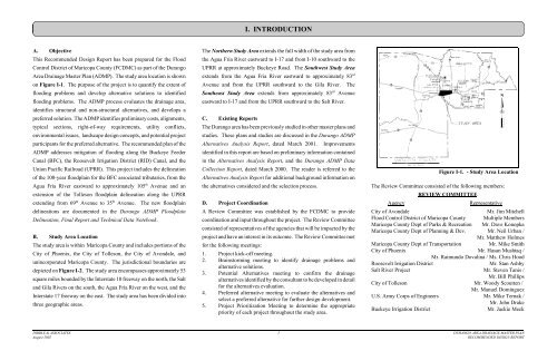
Area Drainage Master Plan (ADMP). The study area location is shown<br />
on Figure I-1. The purpose <strong>of</strong> the project is to quantify the extent <strong>of</strong><br />
flooding problems and develop alternative solutions to identified<br />
flooding problems. The ADMP process evaluates the drainage area,<br />
identifies structural and non-structural alternatives, and develops a<br />
preferred solution. The ADMP identifies preliminary costs, alignments,<br />
typical sections, right-<strong>of</strong>-way requirements, utility conflicts,<br />
environmental issues, landscape design concepts, and potential project<br />
participants for the preferred alternative. The recommended plan <strong>of</strong> the<br />
ADMP addresses mitigation <strong>of</strong> flooding along the Buckeye Feeder<br />
Canal (BFC), the Roosevelt Irrigation <strong>District</strong> (RID) Canal, and the<br />
Union Pacific Railroad (UPRR). This project includes the delineation<br />
<strong>of</strong> the 100-year floodplain for the BFC associated tributaries, from the<br />
Agua Fria River eastward to approximately 105 th Avenue and an<br />
extension <strong>of</strong> the Tolleson floodplain delineation along the UPRR<br />
extending from 69 th Avenue to 35 th Avenue. The new floodplain<br />
delineations are documented in the Durango ADMP <strong>Flood</strong>plain<br />
Delineation, Final <strong>Report</strong> and Technical Data Notebook.<br />
B. Study Area Location<br />
The study area is within <strong>Maricopa</strong> <strong>County</strong> and includes portions <strong>of</strong> the<br />
City <strong>of</strong> Phoenix, the City <strong>of</strong> Tolleson, the City <strong>of</strong> Avondale, and<br />
unincorporated <strong>Maricopa</strong> <strong>County</strong>. The jurisdictional boundaries are<br />
depicted on Figure I-2. The study area encompasses approximately 53<br />
square miles bounded by the Interstate 10 freeway on the north, the Salt<br />
and Gila Rivers on the south, the Agua Fria River on the west, and the<br />
Interstate 17 freeway on the east. The study area has been divided into<br />
three geographic areas.<br />
The Northern Study Area extends the full width <strong>of</strong> the study area from<br />
the Agua Fria River eastward to I-17 and from I-10 southward to the<br />
UPRR at approximately Buckeye Road. The Southwest Study Area<br />
extends from the Agua Fria River eastward to approximately 83 rd<br />
Avenue and from the UPRR southward to the Gila River. The<br />
Southeast Study Area extends from approximately 83 rd Avenue<br />
eastward to I-17 and from the UPRR southward to the Salt River.<br />
C. Existing <strong>Report</strong>s<br />
The Durango area has been previously studied in other master plans and<br />
studies. These plans and studies are discussed in the Durango ADMP<br />
Alternatives Analysis <strong>Report</strong>, dated March 2001. Improvements<br />
identified in this report are based on preliminary information contained<br />
in the Alternatives Analysis <strong>Report</strong>, and the Durango ADMP Data<br />
Collection <strong>Report</strong>, dated March 2000. The reader is referred to the<br />
Alternatives Analysis <strong>Report</strong> for additional background information on<br />
the alternatives considered and the selection process.<br />
D. Project Coordination<br />
A Review Committee was established by the FCDMC to provide<br />
coordination and input throughout the project. The Review Committee<br />
consisted <strong>of</strong> representatives <strong>of</strong> the agencies that will be impacted by the<br />
project and have an interest in its outcome. The Review Committee met<br />
for the following meetings:<br />
1. Project kick-<strong>of</strong>f meeting.<br />
2. Brainstorming meeting to identify drainage problems and<br />
alternative solutions.<br />
3. Potential Alternatives meeting to confirm the drainage<br />
alternatives identified by the consultant to be developed in detail<br />
for the alternatives evaluation.<br />
4. Preferred alternative meeting to evaluate the alternatives and<br />
select a preferred alternative for further design development.<br />
5. Project Prioritization Meeting to determine the appropriate<br />
priority <strong>of</strong> each project throughout the study area.<br />
Figure I-1. - Study Area Location<br />
The Review Committee consisted <strong>of</strong> the following members:<br />
REVIEW COMMITTEE<br />
Agency<br />
Representative<br />
City <strong>of</strong> Avondale<br />
Mr. Jim Mitchell<br />
<strong>Flood</strong> <strong>Control</strong> <strong>District</strong> <strong>of</strong> <strong>Maricopa</strong> <strong>County</strong> Multiple Members<br />
<strong>Maricopa</strong> <strong>County</strong> Dept <strong>of</strong> Parks & Recreation Mr. Dave Konopka<br />
<strong>Maricopa</strong> <strong>County</strong> Dept <strong>of</strong> Planning & Dev. Mr. Neil Urban /<br />
Mr. Matthew Holmes<br />
<strong>Maricopa</strong> <strong>County</strong> Dept <strong>of</strong> Transportation<br />
Mr. Mike Smith<br />
City <strong>of</strong> Phoenix Mr. Hasan Mushtaq /<br />
Mr. Raimundo Dovalina / Ms. Chris Hood<br />
Roosevelt Irrigation <strong>District</strong><br />
Mr. Stan Ashby<br />
Salt River Project Mr. Steven Tanis /<br />
Mr. Bill Phillips<br />
City <strong>of</strong> Tolleson Mr. Woody Scoutten /<br />
Mr. Manuel Dominguez<br />
U.S. Army Corps <strong>of</strong> Engineers Mr. Mike Ternak /<br />
Mr. John Drake<br />
Buckeye Irrigation <strong>District</strong><br />
Mr. Jackie Meck<br />
DIBBLE & ASSOCIATES 1 DURANGO AREA DRAINAGE MASTER PLAN<br />
August 2002<br />
RECOMMENDED DESIGN REPORT


