

Metro Phoenix Area Drainage Master Plan - Flood Control District of ...
Metro Phoenix Area Drainage Master Plan - Flood Control District of ...
Metro Phoenix Area Drainage Master Plan - Flood Control District of ...

You also want an ePaper? Increase the reach of your titles
YUMPU automatically turns print PDFs into web optimized ePapers that Google loves.
Supervisor Mary Rose Wilcox, <strong>District</strong> 5; Supervisor Andy Kunasek, <strong>District</strong> 3; Supervisor Don Stapley, <strong>District</strong> 2<br />
AUGUST 2008<br />
<strong>Area</strong> <strong>Drainage</strong> <strong>Master</strong> <strong>Plan</strong> Purpose<br />
The <strong>Flood</strong> <strong>Control</strong> <strong>District</strong> <strong>of</strong> Maricopa County (<strong>District</strong>),<br />
in association with the City <strong>of</strong> <strong>Phoenix</strong> (City), is<br />
finalizing the <strong>Metro</strong> <strong>Phoenix</strong> <strong>Area</strong> <strong>Drainage</strong> <strong>Master</strong> <strong>Plan</strong><br />
(<strong>Metro</strong> ADMP). The <strong>Metro</strong> ADMP quantifies the extent<br />
<strong>of</strong> drainage and flooding problems within the study area<br />
and develops a concept drainage plan to mitigate the<br />
flooding hazards. The City and the <strong>District</strong> will use the<br />
final recommended conceptual drainage plan to identify,<br />
define, and budget future drainage improvement<br />
projects.<br />
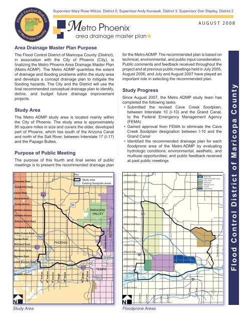
Study <strong>Area</strong><br />
The <strong>Metro</strong> ADMP study area is located mainly within<br />
the City <strong>of</strong> <strong>Phoenix</strong>. The study area is approximately<br />
90 square miles in size and covers the older, developed<br />
part <strong>of</strong> <strong>Phoenix</strong>, which lies south <strong>of</strong> the Arizona Canal<br />
and north <strong>of</strong> the Salt River, between Interstate 17 (I-17)<br />
and the Papago Buttes.<br />
Purpose <strong>of</strong> Public Meeting<br />
The purpose <strong>of</strong> this fourth and final series <strong>of</strong> public<br />
meetings is to present the recommended drainage plan<br />
Greenway Road<br />
Thunderbird Road<br />
Cactus Road<br />
Peoria Avenue<br />
Dunlap Avenue<br />
Northern Avenue<br />
Glendale Avenue<br />
Bethany Home Road<br />
Camelback Road<br />
Indian School Road<br />
Thomas Road<br />
McDowell Road<br />
Van Buren Street<br />
Buckeye Road<br />
Lower Buckeye Road<br />
Broadway Road<br />
Southern Avenue<br />
Iv<br />
!"$a<br />
35 th Avenue<br />
!"c$<br />
27 th Avenue<br />
19 Ave nu e<br />
th<br />
7 Ave nu e<br />
th<br />
PHOENIX<br />
7 th Street<br />
16 St ree t<br />
th<br />
24 th Street<br />
Key<br />
?¸<br />
32 nd Street<br />
Study area<br />
Existing floodplain areas<br />
Aá<br />
!"a$<br />
40 Street<br />
th<br />
48 St ree t<br />
th<br />
PARADISE<br />
VALLEY<br />
Iv<br />
Sco ttsd a le R o a d<br />
Að<br />
TEMPE<br />
SCOTTSDALE<br />
for the <strong>Metro</strong> ADMP. The recommended plan is based on<br />
technical, environmental, and public input consideration.<br />
Public comments and feedback received throughout the<br />
project and at previous public meetings held in July 2005,<br />
August 2006, and July and August 2007 have played an<br />
important role in selecting the recommended plan.<br />
Study Progress<br />
Since August 2007, the <strong>Metro</strong> ADMP study team has<br />
completed the following tasks:<br />
• Submitted the revised Cave Creek floodplain,<br />
between Interstate 10 (I-10) and the Grand Canal,<br />
to the Federal Emergency Management Agency<br />
(FEMA)<br />
• Gained approval from FEMA to eliminate the Cave<br />
Creek floodplain designation between I-10 and the<br />
Grand Canal<br />
• Identified the recommended drainage plan for each<br />
floodprone area <strong>of</strong> the <strong>Metro</strong> ADMP by evaluating<br />
hydrologic conditions; environmental, aesthetic, and<br />
multiuse opportunities; and public feedback received<br />
at past public meetings<br />
Greenway Road<br />
Thunderbird Road<br />
Cactus Road<br />
PeoriaAvenue<br />
Dunlap Avenue<br />
Northern Avenue<br />
GlendaleAvenue<br />
Bethany Home Road<br />
Camelback Road<br />
Indian School Road<br />
Thomas Road<br />
McDowell Road<br />
Van Buren Street<br />
Buckeye Road<br />
!"a$<br />
Lower Buckeye Road<br />
Broadway Road<br />
!"c$<br />
Iv<br />
?¸<br />
!"a$<br />
Aá<br />
Key<br />
Study area<br />
Existing floodplain areas<br />
Cave Creek<br />
Downtown<br />
Durango Curve<br />
Arcadia<br />
Airport North<br />
Sco ttsdale R o ad<br />
Að<br />
<strong>Flood</strong> <strong>Control</strong> <strong>District</strong> <strong>of</strong> Maricopa County<br />
Southern Avenue<br />
35 th Avenue<br />
27 Avenue<br />
th<br />
19 Avenue<br />
th<br />
7 Avenue<br />
th<br />
7 th Street<br />
16 Street<br />
th<br />
24 th Street<br />
32 nd Street<br />
40 Street<br />
th<br />
48 Street<br />
th<br />
Iv<br />
Study <strong>Area</strong><br />
<strong>Flood</strong>prone <strong>Area</strong>s
19 th Avenue<br />
th<br />
e nu e<br />
Av<br />
7<br />
t<br />
24th<br />
th<br />
e t<br />
e<br />
Str<br />
4<br />
page 2<br />
RECOMMENDED PLAN<br />
The <strong>Metro</strong> ADMP began as a comprehensive drainage<br />
study <strong>of</strong> the central metro <strong>Phoenix</strong> area. A multidisciplinary<br />
study team conducted technical research and provided<br />
numerous opportunities for public feedback on the<br />
development <strong>of</strong> drainage plan alternatives. Based on this<br />
technical research and public feedback, the study team has<br />
developed a recommended drainage plan that is technically<br />
sound, environmentally sensitive, responsive to community<br />
needs, and complementary to existing land use.<br />
Downtown <strong>Area</strong><br />
<strong>Drainage</strong> Issues – The downtown area is subject to substantial flood flows, as evidenced by the August 2005 and July 2008<br />
fl oods that caused considerable disruption to the downtown areas. These fl ooding problems are largely due to development<br />
and the lack <strong>of</strong> open, undeveloped land that can absorb water.<br />
Recommended <strong>Drainage</strong> <strong>Plan</strong> – New storm drains north and south <strong>of</strong> railroad; estimated cost $48 million<br />
• Increase the capacity <strong>of</strong> the storm<br />
drain system from the existing<br />
2-year design to provide a 10-year<br />
level <strong>of</strong> protection<br />
• Use excess capacity <strong>of</strong> existing<br />
storm drains in 19th, 15th, 11th,<br />
and 7th Avenues, as well as 12th<br />
and 16th Streets<br />
• Construct new storm drains<br />
both in 3rd and 9th Avenues<br />
and in Fillmore Street that drain<br />
to the Arizona Department <strong>of</strong><br />
Transportation’s (ADOT) existing<br />
drainage system<br />
• Construct new storm drains south<br />
<strong>of</strong> the railroad in 7th Avenue<br />
and 7th Street that drain to the<br />
Salt River<br />
Durango Curve <strong>Area</strong><br />
Downtown and Durango Curve Recommended <strong>Drainage</strong> <strong>Plan</strong><br />
<strong>Drainage</strong> Issues – Most <strong>of</strong> the study area drains into this location upstream <strong>of</strong> the I-17 Durango Curve. If the capacity <strong>of</strong><br />
the storm drain system in this area is exceeded, ponding <strong>of</strong> stormwater behind the elevated I-17 freeway results in flooding<br />
<strong>of</strong> a number <strong>of</strong> homes and businesses.<br />
Recommended <strong>Drainage</strong> <strong>Plan</strong> – 100-year collection system with stormwater storage at Durango Curve; estimated cost<br />
$74 million<br />
• Provide a 100-year level <strong>of</strong> protection for the Durango Curve area<br />
• Construct a new large-diameter storm drain and open channel to<br />
collect stormwaters and drain them into a new multiuse stormwater<br />
storage basin at the Durango Curve<br />
• Use ADOT’s existing 102-inch storm drain to discharge stormwater<br />
from the new storage basin into the Salt River<br />
• Apply a suburban park landscape theme to complement multiuse <strong>of</strong><br />
the basin and enhance local community character<br />
Arcadia <strong>Area</strong><br />
27 th Avenue<br />
!"c$<br />
!<br />
Lower Buckeye Road<br />
Existing<br />
storm drai<br />
<strong>Drainage</strong> Issues – The Arcadia area is subject to flooding from<br />
Camelback Mountain run<strong>of</strong>f. In addition, several properties located<br />
in the low-lying area downstream <strong>of</strong> the Arizona Country Club have a<br />
history <strong>of</strong> flooding.<br />
Recommended <strong>Drainage</strong> <strong>Plan</strong> – New storm drain system; estimated<br />
cost $36 million<br />
• Provide a 10-year level <strong>of</strong> protection for the Arcadia / Old Crosscut<br />
Canal watershed<br />
• Construct new 10-year storm drains in Camelback Road, Lafayette<br />
Boulevard, Arcadia Drive, Invergordon Road, and Thomas Road<br />
$ $<br />
!<br />
$ $<br />
!<br />
! !<br />
!<br />
!<br />
e<br />
e<br />
Str<br />
th<br />
7<br />
McDowell Road<br />
!"a $<br />
Van Buren Street<br />
Lincoln Drive<br />
Buckeye Road<br />
!<br />
Indian School Road<br />
Thomas Road<br />
McDowell Road<br />
Street<br />
th<br />
16<br />
Arizona Canal<br />
Diversion Channel<br />
Old Crosscut Canal<br />
!<br />
!<br />
Að Aá<br />
Tatum Boulevard<br />
Arizona<br />
56 th Street<br />
Key<br />
Arcadia /Old Crosscut Canal<br />
Recommended <strong>Drainage</strong> <strong>Plan</strong><br />
<strong>Flood</strong>prone area<br />
Proposed storm drain<br />
Proposed drainage channel<br />
Proposed stromwater storage<br />
ADOT drainage tunnel<br />
100-year floodplain<br />
! Connection to existing<br />
drainage system<br />
2 St<br />
Canal<br />
SR-202<br />
Van BurenSt<br />
Sky HarborInternational Airport<br />
!"a$<br />
Key<br />
<strong>Flood</strong>prone area<br />
Proposed storm drain<br />
100-year floodplain<br />
Existing drainage channel<br />
! Connection to existing<br />
drainage system<br />
64 th Street<br />
!<br />
SR-202 Westbound<br />
32nd St<br />
Scottsdale Road<br />
Camelback Road<br />
Existing<br />
storm drain<br />
Hayden Road
t h<br />
page 3<br />
Cave Creek <strong>Flood</strong>plain<br />
<strong>Drainage</strong> Issues – The topography <strong>of</strong> the area causes run<strong>of</strong>f<br />
from large storms to exceed the capacity <strong>of</strong> the storm drain<br />
system and flood low-lying areas. This area was part <strong>of</strong> the<br />
Cave Creek floodplain before construction <strong>of</strong> the Arizona Canal<br />
Diversion Channel (ACDC). Even though the ACDC diverts<br />
stormwater from Cave Creek upstream <strong>of</strong> the Grand Canal,<br />
this area is still subject to shallow flooding.<br />
Recommended <strong>Drainage</strong> <strong>Plan</strong> – New storm drains with<br />
stormwater storage at Palo Verde and Encanto golf courses;<br />
estimated cost $170 million<br />
• Increase the storm drain system capacity from the existing<br />
2-year design to provide a 10-year level <strong>of</strong> protection<br />
• Construct new storm drains in 21st, 18th, 15th, 3rd, and<br />
Central Avenues<br />
• Reconstruct Palo Verde and Encanto golf courses to provide<br />
stormwater storage and enhance playability <strong>of</strong> the courses<br />
• Drain Palo Verde Golf Course stormwater storage into the<br />
existing 15th Avenue storm drain<br />
• Drain Encanto Golf Course stormwater storage into the<br />
existing I-10 freeway drainage system<br />
• Add inlets to the existing storm drains in 19th, 15th, and<br />
7th Avenues to collect the 10-year stormwaters<br />
• Apply a suburban park landscape theme to Palo Verde and<br />
Encanto golf courses to preserve their historic character and<br />
complement the adjacent setting<br />
27 Avenue<br />
!"c$<br />
Arizona Canal<br />
Diversion Channel<br />
Dunlap Avenue<br />
19 Avenue<br />
th<br />
7 Avenue<br />
th<br />
Palo Verde<br />
Golf Course<br />
!<br />
$ $<br />
Key<br />
<strong>Flood</strong>prone area<br />
ADOT drainage tunnel<br />
Proposed storm drain<br />
Proposed stormwater storage<br />
Existing stormwater storage<br />
100-year floodplain<br />
Existing drainage channel<br />
! Connection to existing<br />
drainage system<br />
Northern Avenue<br />
Glendale Avenue<br />
Bethany Home Road<br />
Existing<br />
storm drain<br />
Camelback Road<br />
Indian School Road<br />
Thomas Road<br />
?¸<br />
Grand Canal<br />
!<br />
<strong>Drainage</strong> Issues – Homes along the Grand Canal were built<br />
lower than the elevation <strong>of</strong> the banks <strong>of</strong> the canal, creating<br />
Van Buren Street<br />
a floodplain designation along the upstream (north) side <strong>of</strong><br />
the canal. If the capacity <strong>of</strong> the City’s storm drain system is<br />
exceeded, excess run<strong>of</strong>f backs up behind the canal banks and<br />
may cause flooding to homes and businesses.<br />
Alternatives Considered – In order to remove the 100-year<br />
floodplain designation, several alternatives were investigated.<br />
These alternatives included new storm drains, new detention Cave Creek Recommended <strong>Drainage</strong> <strong>Plan</strong><br />
basins, and the buyout <strong>of</strong> homes located in the floodplain. All<br />
structural alternatives were found to be cost prohibitive and<br />
were not supported by the community.<br />
Recommended <strong>Drainage</strong> <strong>Plan</strong> – Properties subject to frequent flooding may qualify for the <strong>Flood</strong>prone Properties<br />
Assistance Program (FPAP). Through the FPAP, the <strong>District</strong> acquires or floodpro<strong>of</strong>s properties subjected to repetitive<br />
flooding. FPAP participation by property owners is voluntary; however, selection for aid is not automatic. FPAP-eligible<br />
properties are compared to others in Maricopa County that submit to the program, and are prioritized through a ranking<br />
system. Funding determines the number <strong>of</strong> properties that can be selected annually.<br />
Although the recommended plan for the Grand Canal area does not include any structural flood-control elements, the new<br />
10-year storm drain system recommended for the Cave Creek fl oodplain area will provide significant fl ood control for some<br />
homes along the Grand Canal. This storm drain system will not remove the Grand Canal floodplain designation, but it will<br />
significantly reduce flooding frequency.<br />
!"a$<br />
Encanto<br />
Golf Course<br />
7 Street<br />
th<br />
16t Stree t<br />
th<br />
McDowell Road<br />
Buckeye Road<br />
Að
page 4<br />
Airport North <strong>Area</strong><br />
<strong>Drainage</strong> Issues – Substantial stormwater accumulation occurs along the north side <strong>of</strong> Sky Harbor Airport. Similar to the<br />
Cave Creek floodplain, this area is characterized by a wide, shallow floodplain that extends westward toward I-10. Once the<br />
capacity <strong>of</strong> the storm drain system is exceeded, run<strong>of</strong>f accumulates and results in a flood hazard for low-lying properties.<br />
Recommended <strong>Drainage</strong> <strong>Plan</strong> – New<br />
storm drain in Van Buren Street;<br />
estimated cost $25 million<br />
• Provide a 10-year level <strong>of</strong> protection <br />
by increasing the capacity <strong>of</strong> the <br />
storm drain system from the existing <br />
2-year design<br />
• Construct a new storm drain in <br />
Van Buren Street that drains run<strong>of</strong>f <br />
into ADOT’s existing drainage <br />
facility<br />
• Intercept flows from the existing <br />
storm drains in 24th, 32nd, and <br />
40th Streets to allow the Aviation <br />
Department to use the residual <br />
capacity <strong>of</strong> these three existing <br />
storm drains to provide much needed<br />
storm drain capacity for the airport<br />
<br />
?¸<br />
!<br />
!<br />
!"a$<br />
24 th Street<br />
Airport North Recommended <strong>Drainage</strong> <strong>Plan</strong><br />
Revision <strong>of</strong> Cave Creek <strong>Flood</strong>plain<br />
The Cave Creek floodplain review indicated that the average depth <strong>of</strong> stormwaters within some portions <strong>of</strong> the floodplain<br />
does not warrant a floodplain designation. In the area upstream <strong>of</strong> McDowell Road, stormwaters flow over a very wide<br />
area, spreading out between 19th Avenue and 7th Street. This wide, shallow flooding does not meet the criteria for a<br />
floodplain designation, which usually involves more concentrated and deeper flooding. The <strong>District</strong>’s study results were<br />
reviewed and approved by FEMA in January 2008. Results indicate that the floodplain designation can be removed between<br />
McDowell Road and the Grand Canal.<br />
However, the overall flood risk will not change. The area removed from the floodplain is still subject to shallow flooding,<br />
although it does not warrant <strong>of</strong>ficial floodplain designation. The recommended drainage plan presented in this handout is<br />
designed to reduce or eliminate the remaining flooding potential within the existing Cave Creek floodplain.<br />
32 nd Street<br />
McDowell Road<br />
Van Buren Street<br />
Union Pacific Railroad<br />
Sky Harbor International Airport<br />
40 th Street<br />
Aá<br />
Key<br />
<strong>Flood</strong>prone area<br />
ADOT drainage tunnel<br />
Proposed storm drain<br />
100-year floodplain<br />
! Connection to existing<br />
drainage system<br />
Að<br />
Next Steps<br />
<strong>Metro</strong> ADMP – The study team will complete the recommended plan report. The recommended plan will be presented to<br />
the <strong>Flood</strong> <strong>Control</strong> Advisory Board and the <strong>Flood</strong> <strong>Control</strong> Board <strong>of</strong> Directors for endorsement. The <strong>District</strong> and the City will<br />
work together to implement the drainage elements <strong>of</strong> the recommended plan as funding becomes available through future<br />
City bond elections or other funding mechanisms.<br />
For more information, contact:<br />
Afshin Ahouraiyan, P.E., Project Manager<br />
<strong>Flood</strong> <strong>Control</strong> <strong>District</strong> <strong>of</strong> Maricopa County, 2801 W. Durango Street, <strong>Phoenix</strong>, AZ 85009<br />
Tel: 602-506-1501, Fax: 602-506-4601, E-mail: afa@mail.maricopa.gov<br />
www.fcd.maricopa.gov/ads/<strong>Metro</strong>PhxADMP.htm


