NYMTC Regional Pedestrian Safety Study - New York Metropolitan ...
NYMTC Regional Pedestrian Safety Study - New York Metropolitan ...
NYMTC Regional Pedestrian Safety Study - New York Metropolitan ...

You also want an ePaper? Increase the reach of your titles
YUMPU automatically turns print PDFs into web optimized ePapers that Google loves.
<strong>New</strong> <strong>York</strong> City<br />
Subway/Sidewalk Interface Project (NYCDOT and NYC Department of City Planning, 2005):<br />
This project addresses the problem created by the combination of elevated structures with<br />
columns in the street and stairs from platform, bus stops where the bus cannot get to the curb,<br />
high pedestrian volumes, and poor vehicular sight lines. The solutions include refuge islands,<br />
raised medians with bollards, and neckdowns. (Available at:<br />
http://www.nyc.gov/html/dcp/html/transportation/td_projectspedestrian.shtml]<br />
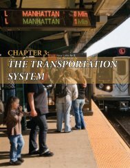
Citywide <strong>Pedestrian</strong> Bridge <strong>Safety</strong><br />
Project (NYCDOT): The most<br />
common safety problem was at the<br />
landing (exit/entrance) to the bridges.<br />
NYCDOT developed a safety toolbox<br />
of remedial measures for addressing<br />
safety problems. Measures include<br />
staggered fencing design, signs,<br />
experimental pedestrian actuated<br />
signals, and markings. To date over 30<br />
(out of 122) bridges have received<br />
remedial treatment.<br />
Figure 3.1 Staggered Fencing at Foot of <strong>Pedestrian</strong> Bridge<br />
Safe Routes to School Projects (NYCDOT, ongoing): A consultant is identifying traffic safety<br />
issues for children walking to school by looking at traffic accidents near 135 primary schools.<br />
This will be continued with the next 135 schools, and followed by a similar study for high<br />
schools. The schools selected for this in-depth analysis were those with a history of safety traffic<br />
issues. The schools not analyzed in this study are covered by a safety net of initiatives offered<br />
through other NYCDOT programs. Another project is assessing the impact of reducing the<br />
speed limit from 30 miles per hour to either 20 mph or 15 mph near 10 schools to determine the<br />
effectiveness of changing posted speed limits. Reports on the Safe Routes to Schools for<br />
individual schools are available at: http://www.nyc.gov/html/dot/html/safety/saferoutes.html<br />
<strong>New</strong> <strong>York</strong> City Bicycle Master Plan (NYCDOT and NYCDCP, May 1997): The goal of the<br />
plan was to increase bicycle ridership with the objective of improving cycling safety. The safety<br />
or suitability of existing roads was ranked using stress level methodology. Although the focus is<br />
on bicycles, the off-street facilities accommodate multi-users such as pedestrians. It also<br />
includes an appendix on pedestrian safety legislation. (Available at:<br />
http://www.nyc.gov/html/dcp/html/bike/mp.shtml)<br />
NYC Greenway Plan (NYCDOT/NYCDCP/NYCDPR, 1993): The Greenway Plan presents the<br />
city's vision for the nation's most ambitious urban greenway system of 350 miles of landscaped<br />
bicycle and pedestrian paths crisscrossing <strong>New</strong> <strong>York</strong> City. Priority routes have been identified<br />
<strong>NYMTC</strong> <strong>Pedestrian</strong> <strong>Safety</strong> <strong>Study</strong> 28