

Powerline Plan and Environ. Assessment Jan. 2013 - Flood Control ...
Powerline Plan and Environ. Assessment Jan. 2013 - Flood Control ...
Powerline Plan and Environ. Assessment Jan. 2013 - Flood Control ...

Create successful ePaper yourself
Turn your PDF publications into a flip-book with our unique Google optimized e-Paper software.
<strong>Powerline</strong> <strong>Flood</strong> Retarding Structure<br />
Pinal County, AZ<br />
Draft Supplemental Watershed <strong>Plan</strong><br />
<strong>and</strong> <strong>Environ</strong>mental <strong>Assessment</strong><br />
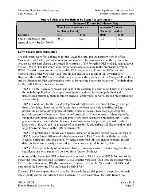
Future Subsidence Predictions by Scenarios (continued)<br />
Estimated Future Subsidence (feet)<br />
Base Case Scenario - No<br />
Recharge Facility<br />
Scenario 2 - With<br />
Recharge Facility<br />
Location<br />
2030 2100 2030 2100<br />
South Rittenhouse FRS<br />
Approximately Station 50+00<br />
-0.1 0.2 -0.1 -0.2<br />
Earth Fissure Risk Delineation<br />
The risk zones were first delineated for the <strong>Powerline</strong> FRS <strong>and</strong> the northern portion of the<br />
Vineyard Road FRS as part of a previous investigation. The risk zones were then updated to<br />
account for the earth fissure discovered downstream of the <strong>Powerline</strong> FRS embankment at about<br />
Station 115+45. The risk zones were further discussed in relation to the proposed <strong>Powerline</strong><br />
IDSM. The risk zones around the <strong>Powerline</strong> FRS, the proposed <strong>Powerline</strong> IDSM <strong>and</strong> the<br />
northern third of the Vineyard Road FRS did not change as a result of this investigation.<br />
However, the earth FRZ was extended south to include the remainder of the Vineyard Road FRS<br />
<strong>and</strong> the Rittenhouse FRS <strong>and</strong> extended north to include the <strong>Powerline</strong> Diversion. The definitions<br />
for the earth FRZ are presented below.<br />
FRZ 1: Earth fissures are present <strong>and</strong> will likely continue to occur in the future as evidenced<br />
through the application of multiple investigative methods, including published <strong>and</strong><br />
unpublished mapping, photolineament analysis, geophysical surveys, ground reconnaissance<br />
<strong>and</strong> trenching.<br />
FRZ 2: Conditions for the past development of earth fissures are present through multiple<br />
lines of evidence; however, earth fissures have not been positively identified. A high<br />
probability of future development of earth fissures is present. Evidence supporting the<br />
possible presence of concealed fissures <strong>and</strong> probability of development of fissuring in the<br />
future includes strain calculations <strong>and</strong> predictions from subsidence modeling, InSAR <strong>and</strong><br />
geodetic survey data, <strong>and</strong> photolineament analysis, as well as proximity to <strong>and</strong> trends of<br />
known earth fissures <strong>and</strong> the presence of known seismic anomalies, soil discontinuities <strong>and</strong><br />
large transverse cracks in the FRS embankments.<br />
FRZ 3: A probability of future earth fissure formation is present, but the risk is less than in<br />
FRZ 2, unless future differential subsidence occurs in FRZ 2, coupled with the currently<br />
elevated horizontal tensional strain. Evidence supporting this designation includes InSAR<br />
data, photolineament analysis, subsidence modeling <strong>and</strong> geodetic survey data.<br />
FRZ 4: A low probability of future earth fissure formation exists. Evidence suggests that no<br />
significant tensional strain will develop from future subsidence.<br />
A portion of the <strong>Powerline</strong> FRS embankment is located in FRZ 1 <strong>and</strong> in FRZ 2. Portions of the<br />
<strong>Powerline</strong> FRS, the proposed <strong>Powerline</strong> IDSM, <strong>and</strong> the Vineyard Road FRS are located within<br />
FRZ 3. The Rittenhouse FRS, the <strong>Powerline</strong> Diversion, most of the Vineyard Road FRS, <strong>and</strong><br />
portions of the <strong>Powerline</strong> FRS are located within FRZ 4.<br />
The earth FRZ were approximated to reflect the earth fissure risk posed to the project through<br />
2025, should current subsidence trends continue. To be conservative, the earth fissure risk<br />
USDA- NRCS <strong>Jan</strong>uary <strong>2013</strong><br />
Kimley-Horn <strong>and</strong> Associates, Inc. Page 37


