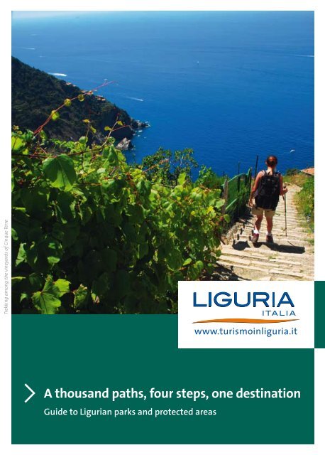
A thousand paths, four steps, one destination
A thousand paths, four steps, one destination
A thousand paths, four steps, one destination

Create successful ePaper yourself
Turn your PDF publications into a flip-book with our unique Google optimized e-Paper software.
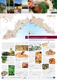
Trekking among the vineyards of Cinque Terre<br />
A <strong>thousand</strong> <strong>paths</strong>, <strong>four</strong> <strong>steps</strong>, <strong>one</strong> <strong>destination</strong><br />
Guide to Ligurian parks and protected areas
www.turismoinliguria.it<br />
Argentina Valley
Liguria<br />
Mare Mediterraneo<br />
FRANCIA<br />
Olivetta<br />
San Michele<br />
15<br />
E<br />
2<br />
ITALIA<br />
Roma<br />
Piemonte<br />
Pigna<br />
Dolceacqua<br />
VENTIMIGLIA<br />
Triora<br />
EUROPA<br />
Colle<br />
di Nava<br />
Pieve<br />
di Teco<br />
Monte M<strong>one</strong>ga<br />
Torino<br />
HP<br />
Monte Galero<br />
A6<br />
Rocca<br />
Barbena<br />
A10<br />
IMPERIA<br />
6<br />
Millesimo<br />
Colle del<br />
Melogno<br />
C<br />
Albenga<br />
ITALIA<br />
8 5<br />
Piana<br />
Crixia<br />
14<br />
Colle di<br />
Cadibona<br />
13<br />
12<br />
17<br />
Monte Carmo<br />
Sassello<br />
Colle del<br />
Giovo<br />
Finale Ligure<br />
Legend<br />
Urbe<br />
A10<br />
Varazze<br />
SAVONA<br />
11<br />
A<br />
Alessandria<br />
A26<br />
Monte Beigua<br />
PROTECTED AREAS (*) Including external areas integrated with the park<br />
1 - Cinque Terre National Park<br />
Regional Natural Parks<br />
2 - Alpi Liguri (*)<br />
3 - Antola (*)<br />
4 - Aveto (*)<br />
5 - Beigua<br />
6 - Bric Tana<br />
7 - Montemarcello Magra (*)<br />
8 - Piana Crixia<br />
9 - Portofino (*)<br />
10 - Porto Venere<br />
16<br />
Campo Ligure<br />
Piani di<br />
Bric del Dente Praglia<br />
Passo del<br />
Turchino<br />
Milano<br />
18<br />
A7<br />
GENOVA<br />
Busalla<br />
Passo dei<br />
Giovi<br />
Crocetta<br />
d’Oreto<br />
A12<br />
Mare Ligure<br />
CS<br />
Passo della<br />
Scoffera<br />
Regional Natural Reserves<br />
11 - Bergeggi<br />
12 - Gallinara<br />
13 - Rio Torsero<br />
14 - Adelasia<br />
Botanic gardens<br />
15 - Hanbury Gardens<br />
16 - Pratorondanino<br />
Torriglia<br />
Other protected areas<br />
17 - Provincial Protected Areas of Savona<br />
18 - Parco delle Mura<br />
9<br />
D<br />
3<br />
Monte<br />
Ramaceto<br />
Rapallo<br />
Borzonasca<br />
Sestri Levante<br />
Santo Stefano<br />
d'Aveto<br />
PROTECTED SEA AREAS<br />
State areas<br />
A - Bergeggi<br />
B - Cinque Terre<br />
C - Island of Gallinara (foreseen)<br />
D - Portofino<br />
Regional areas<br />
E - Hanbury<br />
F - Portovenere<br />
4<br />
Passo di<br />
Cento Croci<br />
Monte S. Nicolao<br />
Levanto<br />
B<br />
HP - High Path of the Ligurian Mountains<br />
CS - Cetacean Sanctuary<br />
Emilia Romagna<br />
Monte Gottero<br />
1<br />
HP<br />
Riomaggiore<br />
Toscana<br />
A12<br />
LA SPEZIA<br />
10<br />
Passo del<br />
Rastrello<br />
F<br />
Lerici<br />
Parma<br />
A15<br />
CEPARANA<br />
7<br />
Pisa
Index<br />
High Path of the Ligurian Mountains pag. 2 - 3<br />
Regional Natural Park of the Ligurian Alps pag. 4 - 6<br />
Piana Crixia and Bric Tana Regional Natural Parks pag. 7 - 9<br />
Beigua Regional Natural Park pag. 10 - 12<br />
Antola Regional Natural Park pag. 13 - 15<br />
Aveto Regional Natural Park pag. 16 - 18<br />
Portofino Regional Natural Park pag. 19 - 21<br />
Cinque Terre National Park pag. 22 - 24<br />
Porto Venere Regional Natural Park pag. 25 - 27<br />
Montemarcello-Magra Regional Natural Park pag. 28 - 30<br />
Bergeggi, Gallinara and Rio Torsero Regional Natural Reserves pag. 31 - 33<br />
Hanbury Botanical Gardens Regional Protected Area<br />
Pratorondanino Provincial Protected area pag. 34 - 35<br />
“Parco delle Mura” Natural Protected Area of local interest pag. 36<br />
“Adelasia” Regional Natural Reserve pag. 37<br />
Editorial information<br />
Editorial project and Copyright on all rights reserved to: Agenzia Regionale per la promozi<strong>one</strong> turistica “in Liguria”.<br />
Images: provided by Enti Parco della Liguria or taken from the archive of the “in Liguria” Agency. With the precious and essential collaboration of the Department<br />
of Territorial Planning - Service for Parks and Protected Areas of Liguria Region and Regional System of Ligurian protected areas.<br />
The section dedicated to Hospitality can be analyzed in details on the websites of the single parks, on website www.altaviadeimontiliguri.it, or<br />
www.turismoinliguria.it, section “accommodation”; the facilities menti<strong>one</strong>d are those indicated by the Parks.<br />
Translation: Eurologos - Genova. Graphic project by Adam Integrated Communications - Turin - Print year 2011.<br />
Warning on liability: despite the accurate verification of the contents, the “in Liguria” Agency is not liable for the contents and information contained in this<br />
guide. Data updated up to February 2010.<br />
We recommend to always verify the information contained in the guide, by calling the numbers indicated.<br />
www.turismoinliguria.it
HIgH PatH of tHe LIgurIan MountaIns<br />
surface covered: over 700 km, 400 km of which are “main route” and 300 km are “connection <strong>paths</strong>”<br />
(there are 80 official connections from Ventimiglia to Ceparana)<br />
The Cottian Alps seen from the Alta Via - Photographed by L. Jelenkovic<br />
2<br />
Municipalities involved: The municipalities falling within Alta Via are 70, distributed in 4 Ligurian provinces;<br />
Alta Via crosses the Alpi Liguri, Beigua, Aveto and Montemarcello-Magra regional Parks and is connected to<br />
Piana Crixia, Bric Tana, Antola and Portofino regional Parks and to the Parco Urbano delle Mura.<br />
Managed by: Associazi<strong>one</strong> Alta Via dei Monti Liguri c/o Uni<strong>one</strong> Camere Commercio Liguri, Via S. Lorenzo, 15,<br />
Genoa - Tel. +39 010 24852200 - Fax +39 010 2471522 - email: segreteria@altaviadeimontiliguri.it<br />
Website: www.altaviadeimontiliguri.it<br />
Information points: In addition to the Secretary Office (which can also be contacted by calling mobile +39 346<br />
6873556), 7 Service Centres with information points (seasonal) are present at (*);<br />
CST Nava, Colle di Nava, Pornassio (IM) • CST Savona, Amm.ne Provinciale di Savona (Parks Office), Savona (SV)<br />
CST Sassello, Centro Visite Parco Beigua - Palazzo Gervino, Sassello (SV) • CST Mignanego, Casa Comunale<br />
(Auditorium), Mignanego (GE) • CST Torriglia, Centro visite parco Antola - La Torriglietta, Torriglia (GE) • CST<br />
Bocco, Sede Parco Aveto, Borzonasca (GE) • CST Calice al Cornoviglio, Castello Malaspina, Calice al Cornoviglio<br />
(SP). (*) For information and opening hours, visit Alta Via website or call the toll free number +39 800 445 445<br />
Description of the territory<br />
It is an excursion path which follows the Tyrrhenian-Po watershed, from the Maritime Alps to Ceparana,<br />
connecting the two extremities of the Ligurian Riviera. A unique route, from which it is possible to admire,<br />
at the same time, Corsica and Gorgona, Monviso and Monte Rosa; where windy ridges and soft slopes with<br />
underbushes filled with scents and colours alternate each other. Along this path, it is possible to find countless<br />
traces of the historical and cultural heritage: from the imposing fortifications of the west to the several and<br />
ancient rural settlements located, in some points of the path, on the crest.<br />
How to get there<br />
The itinerary is subdivided into 43 stopping places which can mainly be reached by private transport from the<br />
coast or from the Po hillside. Many stopping places can be reached by public transport (www.orariotrasporti.<br />
regi<strong>one</strong>.liguria.it) and others (Ventimiglia, Cadibona, Giovi and Orero) can be reached by train. In order to<br />
favour movements and favour sustainable mobility, shuttle services have been created, that can also be used<br />
by individuals with disabilities and can also transport bicycles (see information points, CST).
Beauties of the High Path (Alta Via)<br />
Outside the protected natural areas, which<br />
constitute the main junctions, the Alta Via crosses<br />
other areas of great naturalistic and historicalenvironmental<br />
importance (see map), among which:<br />
galero: mountain complex constituted by breccias<br />
which form suggestive towers called “St<strong>one</strong> giants”,<br />
also important for the presence of glacial relicts (of<br />
Arctic and Sub-Arctic origin).<br />
Melogno: territory of great naturalistic, historical<br />
and landscape interest, which varies from the<br />
woods of Adelasia (to the West) to Rocca Barbena<br />
(to the East), from the Barbottina beech woods to<br />
the breathtaking panoramic terraces of M. Carmo<br />
di Loano.<br />
Praglia: extensive upland, bordering the Parco delle<br />
Capanne di Marcarolo (AL), with the presence of<br />
numerous species of local flora of the humid areas<br />
(including some carnivorous plants) and deer.<br />
gottero: the highest peak of Western Liguria rises,<br />
with its mass, at the border with Tuscany and<br />
Emilia-Romagna, next to the Passo di Cento Croci.<br />
Hospitality<br />
The AVML Association has promoted, during 2009,<br />
a journey of “requalification of the accommodation<br />
facilities concerning the itinerary and the<br />
connecting <strong>paths</strong>”, involving different types of<br />
accommodation facilities already operating with the<br />
Association or contacting others. A brochure with<br />
detailed information on 72 accommodation facilities<br />
is available on the official web site.<br />
Tourist amenity<br />
Outdoor activities<br />
Besides the excursions on foot, on horseback and<br />
by bicycle (please see sections of website dedicated<br />
to these excursions), other sports activities can<br />
be practised such as: paragliding (S. Bernardo di<br />
Mendatica; M.Leco), cross-country ski (Melosa, Park<br />
Aveto), hiking and mountain-climbing (great part<br />
of the watershed) mountain-climbing and free<br />
climbing (Baiarda), canyoning, orienteering.<br />
Historical and rural villages, monuments and<br />
other attractions<br />
Every leg of the Alta Via represents an opportunity<br />
to organize the visit to a village, a castle, a museum,<br />
but also to participate at <strong>one</strong> of the traditional<br />
festivals and feasts which, all year round, enliven<br />
the territory of Liguria. Testimonies of the historical<br />
and cultural heritage are present a bit everywhere<br />
along the whole route. Among those, just to name<br />
a few, the villages of Realdo and Verdeggia (IM),<br />
Castelvecchio di Roccabarbena (SV), Canate and<br />
Ventarola (GE), Zignano and Bolano (SP).<br />
Nature<br />
As it is the “connective tissue” of the locations<br />
belonging to the Natura 2000 network and of the<br />
Regional Parks’ system, the alta Via represents<br />
the main aisle of the regional ecological network,<br />
which is above all precious due to its macro fauna.<br />
In 2004, as a matter of fact, a wolf with a radio collar<br />
has migrated from the Emilian Apennine to the<br />
Maritime Alps, taking advantage of this important<br />
natural road.<br />
The Geremia fort nearby Cappelletta di Mas<strong>one</strong> - Photographed by G. Diviacco<br />
3
egIonaL naturaL ParK of tHe LIgurIan aLPs<br />
area: 12,813 hectares among which: 6,041 hectares of “natural Park” and 6,772 hectares of “Protected area”<br />
Peonies - Mount Pietravecchia - Photographed by Lauro Laura<br />
4<br />
Municipalities involved: Cosio d’Arroscia, Mendatica, Montegrosso Pian Latte, Pigna, Rezzo,<br />
Rocchetta Nervina, Triora.<br />
Managed by: Ente Parco delle Alpi Liguri c/o Provincia di Imperia - Viale Matteotti, 147 - 18100 Imperia<br />
http://parcoalpiliguri.provincia.imperia.it<br />
Information points: town hall of each of the seven municipalities of the Park (Porte del Parco):<br />
Cosio D’Arroscia +39 0183 327847 • Mendatica +39 0183 328713 - Iat +39 0183 38489<br />
Montegrosso Pian Latte +39 0183 328731 • Pigna +39 0184 241016 • Rezzo +39 0183 34015<br />
Rocchetta Nervina +39 0184 207942 • Triora +39 0184 94049 - Iat +39 0184 94477<br />
Description of the territory<br />
The park, which has been recently instituted (lr 24/07), is subdivided into <strong>four</strong> areas of great natural<br />
importance (“natural park”) integrated and connected by areas that are of great interest due to their<br />
landscape and strong cultural identity (“protected areas”). Bordering France and Piedmont, it includes 6<br />
SIC (Sites of community importance) and 4 ZPS (Areas of special protection), the highest peak of Liguria<br />
(Saccarello, 2 200 metres), the deepest cave (Melosa), some of the most extraordinary stretches of the Alta<br />
Via dei Monti Liguri and many more areas of great naturalistic and environmental importance. It is managed<br />
by a special Body which has the objective to preserve and promote the historic integration between nature<br />
and culture (peculiar is the Ligurian-Occitan root of the local communities), to develop new outdoor leisure<br />
activities (environmentally friendly) and to contribute to the revitalization of traditional activities connected<br />
to the wood, breeding and quality agricultural productions.<br />
How to get there<br />
By car: from the coast, going from north to south along the three main valleys, respectively by: SS 28 to arrive<br />
at the entrance of the Park in Valle Arroscia, SP 543 to arrive to Triora in Valle Argentina, SP 64 to arrive at the<br />
two entrances of the Park in Valle Nervia.<br />
By bus: Riviera Trasporti (www.rivieratrasporti.it)
Beauties of the Park<br />
Pian Cavallo is of the most important naturalistic<br />
areas of Liguria, with extensive and valuable wood<br />
areas and Karst areas of European importance such<br />
as the Gola delle Fascette.<br />
The saccarello, frontè and M<strong>one</strong>ga Mounts<br />
constitute the bench marks of the highest mountain<br />
range of Liguria and they are characterized by<br />
extensive prairies and suggestive views.<br />
the territory of the gerb<strong>one</strong> and<br />
toraggio-Pietravecchia Mounts, extremely<br />
spectacular, hosts very different habitats and a high<br />
number of endemic species. The last two, especially,<br />
are known for their uniqueness within the whole<br />
mountain range due to their geological substratum<br />
and their relative vicinity to the sea.<br />
the state forest testa d’alpe and the valley of<br />
the torrente Barbaira host woods, small lakes<br />
and waterfalls of naturalistic interest and great<br />
landscape value.<br />
Hospitality<br />
(Specific references to accommodation facilities are<br />
on the website of the Park)<br />
Cosio d’arroscia: 1 guesthouse<br />
Mendatica: 2 hotels, 1 guesthouse, 2 farmhouses,<br />
1 bed & breakfast, 1 holiday camp<br />
Montegrosso Pian Latte: 1 farmhouse, 1 guesthouse<br />
Pigna: 1 hotel with spa, 3 farmhouses,<br />
4 bed & breakfast, 4 mountain huts<br />
rezzo: 2 hotels, 2 farmhouses<br />
rocchetta nervina: 1 hotel, 1 farmhouse,<br />
2 bed & breakfast<br />
triora: 2 hotels, 1 guesthouse, 1 bed & breakfast,<br />
4 mountain huts<br />
Tourist amenity<br />
Hiking<br />
In the park, the Alta Via dei Monti Liguri (for about<br />
45 km) and the Via Alpina (for about 35 km);<br />
other hiking trails connect different areas locally.<br />
Additional itineraries, at times coinciding with<br />
hiking trails, have been indicated for MTB (“Alpi del<br />
Mare in bici” - www.alpidelmareinbici.it) and others<br />
are used by associations and guides for excursions<br />
on snowshoes and horse trekking.<br />
theme trails: “Memoria delle Alpi”<br />
(www.memoriadellealpi.net), “A caccia di fioriture”<br />
(http://fioriture.provincia.imperia.it), Ecomuseo<br />
della Biodiversità (http://biodiversita.provincia.<br />
imperia.it)<br />
trials that can be assessed by everybody: in<br />
San Bernardo di Mendatica for partially sighted<br />
individuals, in Melosa (Pigna) for partially sighted<br />
and disabled individuals.<br />
Outdoor activities<br />
Paragliding in San Bernardo di Mendatica<br />
free climbing in Loreto (Triora)<br />
Cross-country skiing in Melosa (Pigna)<br />
Canyoning along the rivers Barbaira, Argentina and<br />
affluents and Rio Santa Lucia (Valle Arroscia)<br />
skiing M<strong>one</strong>si<br />
Historical and rural villages, monuments and<br />
other attractions<br />
Historical villages: particularly suggestive for the<br />
compact structure that unifies the buildings to form<br />
a single organism run through by alleys and flights<br />
of <strong>steps</strong>, partly covered, are the historical villages<br />
of: Rocchetta Nervina, Pigna, Buggio (Pigna), Loreto<br />
(Triora), Realdo (Triora), Verdeggia (Triora), Triora,<br />
Rezzo, Cenova (Rezzo), Lavina (Rezzo), Montegrosso<br />
Pian Latte, Mendatica, Valcona (Mendatica), Cosio<br />
d’Arroscia.<br />
rural villages: shepherd’s huts of the Ligurian Alps -<br />
seasonal agropastoral settlements<br />
Mount Toraggio - Photographed by Lauro Laura<br />
5
Mount Pietravecchia - Photographed by MC. Caprioglio<br />
6<br />
Historical monuments: countless, among which<br />
Medieval buildings and bridges, fortifications,<br />
churches and parish youth clubs containing valuable<br />
artworks.<br />
Nature<br />
The peculiarities of geological interest are several,<br />
among which the gola delle fascette (Cosio<br />
d’Arroscia), the arroscia Waterfalls (Mendatica,<br />
Montegrosso P.Latte), hydrothermal springs (Pigna),<br />
the falaises of Loreto and realdo (Triora) and dozens<br />
of caves of significant size. There are also numerous<br />
monumental trees, among which two larches and<br />
<strong>one</strong> silver fir in the State Regional Forest of Gerbonte<br />
(Triora). Peculiarities of botanic interest, object of<br />
international studies, include different endemisms<br />
characterized by the unusual presence of species<br />
that are typical of cold climates and Mediterranean<br />
species; even the fauna, rich and interesting,<br />
includes Mediterranean species, such as the<br />
ocellated lizard, and others that are typically alpine<br />
such as the chamois and the black grouse.<br />
Local productions and typical certified products<br />
Besides the cheese, such as the toma di pecora<br />
Brigasca (*), or products such as the Beans of<br />
Badalucco, Conio and Pigna (*) and the Bread of<br />
Triora, the centennial agricultural and pastoral<br />
transhumance has united the populations of the<br />
Ligurian Alps with those of the area of Cuneo<br />
and of the Occitan valleys, developing the unique<br />
gastronomy called “Cucina Bianca” (starchy food,<br />
dairy products, mountain vegetables that have little<br />
colour such as potatoes, leeks, garlic, turnips or wild<br />
products).*Slow Food® Presidia<br />
Handicrafts<br />
Slate objects, baskets and woodworking.<br />
Educational tourism<br />
environmental educational Centre<br />
Intemelia Mountain Community<br />
excursion tourism Centre “alpi Liguri”<br />
Mendatica<br />
tourist facility Il faggio Coldinava in Pornassio
PIana CrIXIa regIonaL naturaL ParK<br />
area: 795 hectares<br />
Description of the territory<br />
The hilly landscape of Piana Crixia, in the valley of the Bormida di Spigno, has traits similar to the nearby<br />
Langhe of Piedmont. Areas with soft slopes, partly cultivated, alternate to rugged landforms, where the<br />
erosion has created typical badlands. The contrast between the gray of the badlands and the colours of the<br />
fields and surrounding woods creates a suggestive picture, unique in its kind in Liguria. A small isolated area in<br />
the hamlet of Borgo is also part of the park, where the spectacular “Fungo di pietra” (st<strong>one</strong> mushroom) rises.<br />
How to get there<br />
By car: A6 highway Turin-Savona (exit at Altare-Carcare or Millesimo), afterwards take S.S. to Acqui Terme.<br />
By bus: Acts lines: Savona-Cairo; Cairo-Piana crixia (www.acts.it)<br />
By train: railway line: Savona-San Giuseppe-Acqui Terme-Alessandria (Piana Crixia station)<br />
Beauties of the Park<br />
the geological site of european value, located in the hamlet of Borgo rises, for about fifteen metres, the<br />
exceptional “fungo di pietra” (st<strong>one</strong> mushroom), gigantic mass of ophiolite st<strong>one</strong>, supported by a column of<br />
conglomerate.<br />
Hospitality<br />
1 hotel, 1 farmhouse, 1 B&B, 1 guesthouse, 1 resting area for campers.<br />
The St<strong>one</strong> Mushroom - Photographed by M. Paola Chiarl<strong>one</strong><br />
Municipalities involved: Piana Crixia<br />
Managed by: Municipality of Piana Crixia (SV) Tel. +39 019 570021 - Fax: +39 019 570022<br />
e-mail: parco.pianacrixia@libero.it - website: www.parks.it/parco.piana.crixia<br />
Information points: The office of the park located inside the town hall. Park Centre located at the ex<br />
elementary school (currently under construction)<br />
7
8<br />
Tourist amenity<br />
Hiking<br />
Within the park, seven itineraries have been<br />
identified. Shortly, the ancient trail that leads from<br />
the Fungo di pietra (st<strong>one</strong> mushroom) to the town<br />
of Pontevecchio will be added.<br />
Local productions and typical certified products<br />
H<strong>one</strong>y, nocciola “tonda gentile” (hazelnut), ravioli<br />
al plin, polenta and agliata, robiola (soft cheese),<br />
quagliata, bunet, hazelnut cakes and, above all,<br />
white truffle.<br />
BrIC tana regIonaL naturaL ParK<br />
area: 170 hectares<br />
Bric Tana - Parks of the Region of Liguria Archive photograph<br />
Municipalities involved: Millesimo<br />
Managed by: Municipality of Millesimo (SV) - Tel. +39 019 5600044 - Fax+39 019- 564368<br />
ufficiotecnico@comune.millesimo.sv.it - website: www.parks.it/parco.bric.tana<br />
Description of the territory<br />
The gullies among the cultivated fields - Photographed by M. Paola Chiarl<strong>one</strong><br />
Odd lime spires overlook the Bormida river, raising from the thick woods of the regional park, hilly area<br />
mainly covered by chestnut trees and mixed woods, important especially for the presence of Karst forms<br />
above and below ground. The “Tana dell’Orpe” is famous, sinkhole of a dolina South of the municipality of<br />
Millesimo, inside of which pre-historic findings have been recovered. The particular geo-morphology of the<br />
area stands out also in the Valle dei Tre Re, a closed valley, without emissary but boasting an underground<br />
hydrographic network characterised by overhanging gorges that overlook Rio della Feia. The great geological<br />
and geo-morphological importance of Bric Tana also lies in the particular fauna concerning the population of<br />
Chiroptera (bats) which are typical of the area.
How to get there<br />
By car: highway A6 Turin-Savona (toll booth of<br />
Millesimo).<br />
By bus: Acts lines (www.acts.it).<br />
By train: railway line: Savona - San Giuseppe - Acqui<br />
Terme - Alessandria (Cengio station, at 5 km, and S.<br />
Giuseppe di Cairo, at 8 km).<br />
Beauties of the park<br />
Pre-historic and historic testimonies: the most<br />
renowned <strong>one</strong>s are the rock incisions of Biestro,<br />
the “massi delle croci” on the Bric della Costa’s<br />
ridge, the “masso-altare” in Colla, the menhirs of<br />
Millesimo, the archaeological site of the Bronze age<br />
of Bric Tana.<br />
Hospitality<br />
Millesimo: 1 hotel, 2 B&B, 1 Park guesthouse (in<br />
Acquafredda).<br />
Tourist amenity<br />
Hiking<br />
The network of <strong>paths</strong> is constituted by three “short”<br />
tracks and three “long” <strong>one</strong>s.<br />
Local productions and typical certified products<br />
tartufo of Millesimo (black and white), frizze or<br />
grive (cold cuts), giuncata (ricotta made with sheep<br />
milk), and the dolci millesini al rum (rum based<br />
sweets).<br />
Bormida di Millesimo nearby Bric Tana - Photographed by L. Jelenkovic<br />
9
BeIgua regIonaL naturaL ParK (european & unesCo global geopark)(*)<br />
area: 8,715 hectares<br />
View of the Tyrrhenian side, of Mount Rama and of Genoa - C. Queirolo<br />
10<br />
Municipalities involved: Arenzano, Campo Ligure, Cogoleto, Genoa, Mas<strong>one</strong>, Rossigli<strong>one</strong>, Tiglieto<br />
(Province of Genoa) - Sassello, Stella, Varazze (province of Savona)<br />
Managed by: Ente Parco del Beigua, Via Marconi 165, Arenzano (GE) - Tel. +39 010 8590300<br />
Fax. +39 010 8590064 - email: info@parcobeigua.it - website: www.parcobeigua.it<br />
Information points: Visitor Centre “Palazzo Gervino”, Sassello (it houses IAT Sassello) - Tel. +39 019 724020<br />
Visitor centre “Villa Bagnara”, Mas<strong>one</strong> • Ornithological and Environmental Education Centre, in Vaccà,<br />
Arenzano, Information point “Bruno Bacoccoli”, in Prariondo, Cogoleto • Information point “Banilla”, Tiglieto.<br />
Other Tourist Offices (IAT) at: Arenzano (+39 010 9127581), Campo Ligure (+39 010 921055), Varazze (+39 019<br />
935043). N.B. A service Centre is available inside the Park (+39 019 724020) thanks to which it is possible to<br />
enjoy of an integrated transport and naturalistic guiding service relative to the protected area and Alta Via dei<br />
Monti Liguri.<br />
Description of the territory<br />
It is the widest park of Liguria, recognized internationally as (*) European & UNESCO Global Geopark due to<br />
its exceptional geological and landscape heritage. The protected area constitutes a typical cross section of the<br />
region where, even when travelling along newly developed stretches, it is possible to find a much diversified<br />
landscape: a spectacular terrace formed by mountains which overlook the sea. Twenty-six kilometres of<br />
mountain ridges, nearby the Ligurian Riviera, which contain prairies and valuable high altitude humid areas,<br />
thick beech, durmast and chestnut woods, steep cliffs and rocky surfacing, maritime pine forest and stretches<br />
of Mediterranean vegetation.<br />
How to get there<br />
By car: SS 1 Aurelia, SS 334 Sassello; SS 456 Turchino; SS 542 Varazze-Sassello; A10 highway Genoa-Ventimiglia<br />
(exits: Ge-Voltri, Arenzano, Celle Ligure, Albisola) and A26 Voltri-Santhià (exit: Mas<strong>one</strong>)<br />
By bus: ATP line Genoa-Voltri-Valle Stura-Tiglieto and Arenzano-Cogoleto; ACTS line Savona-Albisola-Sassello<br />
and Varazze.<br />
By train: Genoa-Ventimiglia line (stations of: Voltri, Arenzano, Cogoleto, Varazze, Celle Ligure, Albisola);<br />
Genoa-Acqui Terme line (stations of: Campo Ligure and Rossigli<strong>one</strong>).
Beauties of the Park<br />
Prariondo and the alta Via dei Monti Liguri: the core<br />
of the park is its spectacular view of the landscape,<br />
with breathtaking views which range from the Alps<br />
to the whole Ligurian arch.<br />
gargassa Valley: offers views of uncontaminated<br />
beauty, between placid lakes, canyon and suggestive<br />
rocky landforms which have been shaped by water<br />
erosion.<br />
Deiva forest: it can be visited by travelling along<br />
a ring-shaped trail which crosses wide spruce and<br />
Douglas fir woods, black pine and red fir woods,<br />
besides forests mixed with durmasts and other<br />
hardwoods.<br />
Hospitality<br />
(Specific references to accommodation facilities are<br />
on the website of the Park)<br />
arenzano: 3 B&B, 1 farmhouse<br />
Cogoleto: 1 mountain hut<br />
Mas<strong>one</strong>: 1 hotel, 2 B&B<br />
rossigli<strong>one</strong>: 1 hotel, 2 B&B, 2 farmhouses<br />
sassello: 5 hotels, 5 B&B, 2 farmhouses,<br />
1 mountain hut<br />
stella: 5 B&B, 3 farmhouses, 2 campings<br />
tiglieto: 2 hotels, 1 B&B, 1 farmhouse<br />
Varazze: 1 hotel, 1 farmhouse<br />
Tourist amenity<br />
Hiking<br />
In the territory, a well marked hiking network is<br />
present which develops for over 500 kilometres and<br />
it allows reaching many <strong>destination</strong>s of the Park.<br />
Within the protected area, an effective network of<br />
equipped green areas is available.<br />
self-guided educational trails<br />
“Foresta della Deiva” loop trail, Sassello; “Prariondo-<br />
Torbiera Lai<strong>one</strong>” loop trail, Cogoleto; “Curlo-Passo-<br />
Gava”, Arenzano; Alpicella archeological trail,<br />
Varazze; “Val Gargassa” loop trail, Rossigli<strong>one</strong>;<br />
“Eremo del deserto” botanical trail, Varazze; “Case<br />
Vaccà” ornithological trail, Arenzano; “Cascata del<br />
Serpente” botanical trail, Mas<strong>one</strong>; “Giumenta-<br />
Foresta Deiva”, Sassello.<br />
accessible trails: they are available on the Alta Via<br />
dei Monti Liguri (from Prariondo to the Cappelletta<br />
degli Alpini) and at the Badia di Tiglieto.<br />
Outdoor activities<br />
From trekking to nordic walking, from mountain<br />
biking to cross-country skiing, from canyoning to<br />
archery and many more activities can be practised in<br />
the Park. The adventure park “La Maliarda” is a lot<br />
of fun and suited for both children and adults, in the<br />
municipality of Rossigli<strong>one</strong>.<br />
Historical and rural villages, monuments<br />
and other attractions<br />
The Park is considered as “special territory” also<br />
for the presence of a rich architectural, historical<br />
and cultural heritage. Recommended for visits and<br />
excursions: the Badia di tiglieto, first Cistercian<br />
abbey built outside France in 1120, the medieval<br />
spinola Castle of Campo Ligure, the Seventeenthcentury<br />
eremo del Deserto of Varazze, the<br />
Nineteenth-century geremia fort on the high<br />
ground of Mas<strong>one</strong>. The historical villages of sassello<br />
and rossigli<strong>one</strong> are also interesting and rural<br />
settlements spread throughout the entire territory.<br />
Harrier eagle’s nest in the Park - M. Campora<br />
11
12<br />
Nature<br />
Along the most inaccessible trails, hidden from the<br />
sight of men, the wolf regularly travels and from the<br />
counterforts overlooking the sea, it is not unusual<br />
to discern the tapered shapes of whales, exhaling in<br />
the aqueous mirror in front of Varazze. The territory,<br />
considered <strong>one</strong> of the richest biodiversity areas of<br />
Liguria, is also known for the phenomenon of the<br />
migration of birds of prey (Bianc<strong>one</strong>) and can boasts<br />
the presence of the golden eagle, eagle owl, rock<br />
thrush, warbler and over eighty other ornithological<br />
species. The presence of minor fauna (amphibians<br />
and reptiles) and multi-coloured endemic species<br />
of flowers (Viola Bertolonii, Cerastium utriense,<br />
Asplenium cuneifoliu and Daphne cneorum).<br />
Local productions and typical certified products<br />
The very ancient tradition of the confecti<strong>one</strong>ry<br />
industry of Sassello is very important, with the<br />
typical “amaretti” and “canestrelli” or the “crumiri”<br />
of Mas<strong>one</strong>. The wide range of milk products<br />
complete the picture (http://www.parks.it/parco.<br />
beigua/pro-form.stella.html Formaggetta di Stella,<br />
http://www.parks.it/parco.beigua/pro-form.stura.<br />
html Formaggetta della Valle Stura, http://www.<br />
parks.it/parco.beigua/pro-latte.html Latte delle Valli<br />
genovesi), the processing of the bovine meat and<br />
Southern slopes of Mount Malanotte in Val Cerusa - C.Queirolo<br />
sheep meat (http://www.parks.it/parco.beigua/<br />
pro-pate.lardo.html bacon spread, prosciutto<br />
cotto (ham), http://www.parks.it/parco.beigua/<br />
pro-salame.html Salami and prosciutto crudo of<br />
Sassello, http://www.parks.it/parco.beigua/prozeraria.html<br />
Zeraria), the colourful berries, the<br />
longed-for picking and conservation of mushrooms,<br />
and the wide choice of the delicious h<strong>one</strong>y of the<br />
valleys of Beigua.<br />
Educational tourism<br />
The experience Centre (c/o Park location) offers<br />
different opportunities addressed to compulsory<br />
schooling and high schools. The activities include<br />
class meetings, visits to theme exhibition places,<br />
excursions at the discovery of natural, historical<br />
and cultural sites. It is also possible to organize<br />
green holiday weeks or periods of educational<br />
entertainment of <strong>one</strong> or more days, according to<br />
the different needs. An interesting learning area<br />
dedicated to the small inhabitants of the wood is<br />
also available (location Giumenta).
antoLa regIonaL naturaL ParK<br />
area: 10,669 hectares among which: 4837 hectares of “Park area” and 5,832 hectares of “neighbouring area”<br />
Description of the territory<br />
The territory represents an Apennine z<strong>one</strong> of great landscape, naturalistic, historical and cultural value. The<br />
vicinity to Genoa and the Ligurian sea, but also to the cities of Piedmont, Lombardy and Emilia constitute a<br />
point of strength of the park. The Antola Valleys, which include the territories of 12 municipalities between<br />
the Alta Valle Scrivia and the Alta Val Trebbia, constitute an ideal environment to practise naturalistic<br />
excursions thanks to the wide network of itineraries (over 300 km of trails), some of which also suited to<br />
mountain biking, free climbing and mountain climbing (in the territory of the Rocche del Reopasso), winter<br />
walks with cross-country skis and snowshoes along the entire Antola’s ridge, and even horse trekking. The<br />
territory of the Park also allows discovering and enjoying the area from a cultural, gastronomic and historical<br />
point of view with a series of villages, museums and points of interest that are unique within the Genoese<br />
hinterland.<br />
How to get there<br />
By car: by taking the S.S. 45, the S.P. 226 Valle Scrivia and other minor Provincial Roads.<br />
By bus: ATP line “Genoa-Torriglia-Propata-Rondanina-Montebruno” and “Genoa-Montoggio-Casella-<br />
Savign<strong>one</strong>-Crocefieschi-Vobbia”.<br />
By train: Genoa-Milan and Genoa-Turin lines (stations of Busalla, Ronco Scrivia and Isola del Cant<strong>one</strong>)<br />
Narrow gauge line Genoa-Casella (“Casella train”).<br />
Mount Antola Peak<br />
Municipalities involved: Busalla, Crocefieschi, Fascia, Gorreto, Montebruno, Propata, Ronco Scrivia, Rondanina,<br />
Savign<strong>one</strong>, Torriglia, Valbrevenna, Vobbia<br />
Managed by: Ente Parco dell’Antola, Head Office Villa Borzino, Via XXV Aprile 17, Busalla (GE), La Torriglietta<br />
Scientific Office and Visitor Centre, Via N.S. della Provvidenza 3, Torriglia (GE) -Tel. +39 010 944175<br />
Fax. +39 010 9453007 - email: info@parcoantola.it<br />
Information points: Villa Borzino - Busalla (Park location) • La Torriglietta - Torriglia, Experience Centre of the<br />
Park, Tourist Office (IAT) and Territorial Service Centre for the enjoyment of the Alta Via dei Monti Liguri and of<br />
the connecting itineraries • Alta Valle Scrivia Tourist Office (IAT)- Casella (seasonal)<br />
Information point - Gorreto (seasonal)<br />
13
14<br />
Beauties of the Park<br />
Mount antola - Site of Community Importance (SCI)<br />
for the grasslands (flowering) and beechwoods,<br />
Mountain Hut “Parco Antola”.<br />
settlements of Vobbia with Castello della pietra<br />
(St<strong>one</strong> Castle) (rocky environments) and rocche del<br />
reopasso (Reopasso Rocks).<br />
Brugneto Lake: main water basin of the province<br />
of Genoa, which originated from the construction<br />
of a 260 metre long and 80 metre high dam, with a<br />
capacity of 25 million square metres of water, Lago<br />
del Brugneto represents the main water supply of<br />
the city of Genoa and also a site of great naturalistic<br />
value, suited for different types of visitors, that<br />
can be reached thanks to a loop itinerary of 13.5<br />
kilometres, that boasts several equipped areas.<br />
Hospitality<br />
The territory of Antola offers numerous<br />
opportunities of stay and different types of<br />
accommodation facilities, from tourist huts such<br />
as the “Parco Antola” Hut, which is located at the<br />
crossroads of the most interesting and panoramic<br />
itineraries of the Protected Area and the bed &<br />
breakfast, farmhouses and hotels spread all over the<br />
villages and the most interesting <strong>destination</strong>s of the<br />
Park.<br />
Tourist amenity<br />
Hiking<br />
The Park boasts over 280 kilometres of marked trails<br />
suited for different types of hikers.<br />
Self guided educational trails<br />
sentiero dei Castellani (trail), from the town of Torre<br />
(Vobbia) to the Castello della Pietra (St<strong>one</strong> Castle)<br />
Loop trail starting at the Monte antola Hut<br />
sentiero Brugneto (trail)<br />
Loop trail of torriglia<br />
Outdoor activities<br />
Via ferrata (Iron road) at the Rocche del Reopasso<br />
Hiking at Lago del Brugneto<br />
Hiking along the Alta Via dell’Antola (M. Antola - M.<br />
Buio - S. Fermo - M. Reale)<br />
trekking and mountain biking<br />
Paragliding in the town of Monte Maggio<br />
Horse-back riding at the Horse Camp of the Park<br />
“Mulino del Lupo” in torriglia<br />
Castello della Pietra (St<strong>one</strong> Castle)
Historical and rural villages, monuments and other<br />
attractions<br />
Interesting rural settlements can be visited in<br />
Senarega and Chiappa, in Val Brevenna and<br />
Pentema, in Val Pentemina. Among the historical<br />
monuments not to be missed are: the Castello di<br />
Pietra (St<strong>one</strong> Castle), ancient and suggestive country<br />
house built on the ridges of Val Vobbia.<br />
Nature<br />
Charming flowering can be admired in the core of<br />
the park, with narcissuses, orchids, gentians, lilies,<br />
mountain arnica and columbines which cover the<br />
pastures of the Monte Antola. The scenery of the<br />
wild Val Vobbia is as charming, in which natural<br />
conglomerate towers (clastic rocks) and steep slopes<br />
covered by chestnut trees alternate. The fauna<br />
boasts several endemisms besides more common<br />
animals (wolf, deer, roes, foxes and other mammals),<br />
amphibians, reptiles, birds and marvellous<br />
butterflies which colour the Park’s fields (crayfish,<br />
red-backed shrike, euplagia quadripunctaria).<br />
Monumental trees are present in Nenno (Taxus<br />
baccata L.), Senarega (Populus nigra L.), and Vobbia<br />
(Castanea sativa).<br />
Local productions and typical certified products<br />
Besides the typical productions of the hinterland,<br />
in the Park there are exclusive products such as<br />
“quadrelli di castagne” (chestnut based sweets)<br />
and the “marmellata extra di petali di viole” (jam<br />
made with violet petals). Other specialties produced<br />
in the territory of the protected area are: savign<strong>one</strong><br />
Beer, Mostardella, Pesto d’aglio, Quagliata Ligure,<br />
Chestnut flour, Patata quarantina bianca, roses<br />
and syrup of roses, Canestrello Ligure, Canestrelli di<br />
avosso, Pandolce genovese, rising bread, Panett<strong>one</strong><br />
with chestnut flour, torta di torriglia and h<strong>one</strong>y.<br />
Educational tourism<br />
the environmental educational Centre of the Park<br />
promotes activities aimed at getting to know the<br />
naturalistic, historical and cultural heritage of the<br />
Park. (Info is available at the Antola Park Experience<br />
Centre-Tel. 010 944175-www.parcoantola.it/edu).<br />
Reopasso Rocks<br />
15
16<br />
aVeto regIonaL naturaL ParK<br />
area: 5,688 hectares, 3.018 hectares of which as “Park area” and 2,670 hectares of “neighbouring area”<br />
Aveto Valley - Photographed by G. Pagliaga<br />
Municipality involved: Borzonasca, Mezzanego, Ne, Rezzoaglio, Santo Stefano d’Aveto<br />
Managed by: Ente Parco dell’Aveto, Via Marre’ 75A, Borzonasca (GE) - Tel. +39 0185 340311 - Fax +39 0185<br />
343020 - email: parcoaveto@libero.it - website: www.parks.it/parco.aveto<br />
Information points: Info and Environmental Education Centre, Borzonasca (inside the Park) - tel. +39 0185<br />
343370 • Visitors’ Centre, Rezzoaglio (location detached from the Park) - Tel. +39 0185 870171 • Miniera di<br />
Gambatesa, Tel. +39 0185 338876 - Fax +39 0185 338863 - website: info@minieragambatesa.it<br />
IAT (tourist office) in Ne, Rezzoaglio and Santo Stefano d’Aveto. A Service Centre Alta Via is also available at the<br />
park, which offer an integrated transport and naturalistic guide service, for the discovery of the protected area<br />
and Alta Via dei Monti Liguri (also equipped for the transport of disabled people and mountain biking).<br />
Description of the territory<br />
Located in Tigullio’s inland, the Park protects <strong>one</strong> of the most suggestive areas of the Ligurian Apennine,<br />
among which Aveto, Graveglia and Stura valleys, with mountain environments, thick woods and rural<br />
landscapes of rare beauty. From the mountain peaks of Val d’Aveto to the mountain ridges of Valle Stura, at<br />
sheer drop to the sea, the park offers, in a few kilometres, a variety of the most different environments of the<br />
region. Ancient geological ages gave origin to rocks, through enormous movements, that characterise Val<br />
Graveglia, with traditions linked to the exploitation of the sub-soil’s minerals.<br />
How to get there<br />
By car: highway A12 Genoa - Livorno (Chiavari and Lavagna toll booths), Provincial road 586 Val d’Aveto,<br />
Provincial road 26 Val Graveglia, Provincial road 26 bis Passo del Bocco, Provincial road 654 Val di Nure,<br />
Provincial road 56 Barbagelata and Provincial road 23 Scoglina.<br />
By bus: Chiavari - S. Stefano d’Aveto, Chiavari - Conscenti, Chiavari - Bedonia (PC) ATP lines and also TEP line<br />
By train: Genoa - Pisa line (Chiavari and Lavagna stations).
Beauties of the Park<br />
Laghetti glaciali delle Lame (glacial lakes) (Agoraie<br />
Bio-genetic reserve): they preserve rare botanical<br />
species in a unique landscape in Liguria.<br />
gambatesa Mine: once a location of intense<br />
extraction activity of manganese, the complex<br />
houses today a mineral museum that can be visited<br />
on the miners’ train (www.minieragambatesa.it)<br />
Zatta beech grove: <strong>one</strong> of the most beautiful<br />
Ligurian beech groves, crossed by Alta via dei Monti<br />
Liguri and by a Natural Trail, it houses the flora and<br />
fauna typical of the mountain Apennine woods.<br />
Hospitality<br />
(Specific references to accommodation facilities can<br />
be found on the Park’s website)<br />
Borzonasca: 1 hotel, 1 hostel, 8 guesthouses, 2<br />
holiday homes, 4 B&B, 1 mountain hut,<br />
4 farmhouses<br />
Mezzanego: 2 B&B, 1 holiday home, 1 guesthouse,<br />
1 mountain hut<br />
ne: 10 farmhouses, 7 B&B, 1 holiday home,<br />
1 holiday home, 2 guesthouses, 1 mountain hut,<br />
2 inns, 1 flat<br />
rezzoaglio: 6 hotels, 3 mountain huts, 1 holiday<br />
home, 3 guesthouses, 2 farmhouses<br />
santo stefano d’aveto: 6 hotels, 1 farmhouse,<br />
1 B&B, 1 flat, 4 guesthouses, 1 mountain hut<br />
Tourist amenity<br />
Hiking<br />
The Park boasts a thick network of well marked<br />
trails that extends for about 500 km on a territory<br />
extremely rich of geo-morphological, vegetation and<br />
landscape peculiarities. Loop trails and self-guided<br />
educational trails (Natural trails), equipped with<br />
panels and stands are also available.<br />
Outdoor activities<br />
Many trails can be travelled also by horse and<br />
mountain bike while during the winter, it is<br />
possible to practice cross-country skiing (over<br />
20 km of beaten tracks), skiing, hiking, and walk<br />
with snow shoes. Moreover, the Park also offers<br />
the possibility to descend by canoe, practice<br />
canyoning, climbing on spectacular rocky walls and<br />
practice activities such as gliding and paragliding.<br />
A park of adventures among trees (Indian Forest)<br />
is also available at the sport facility of Belpiano<br />
(Borzonasca).<br />
Historical and rural villages, monuments<br />
and other attractions<br />
The Park offers an interesting archaeological,<br />
historical, and landscape heritage and it’s rich<br />
of traditions and typical activities that are still<br />
practiced nowadays. Historic testimonies can be<br />
observed along the medieval road that crosses<br />
Borzonasca, Rezzoaglio and S.Stefano d’Aveto.<br />
Settlements of remarkable interest can be found<br />
in Borz<strong>one</strong>, Villa Cella, and in the villages of Val<br />
Penna, but more diffused and still very interesting<br />
testimonies of the rural culture and tradition can be<br />
found scattered all over the territory of the Park.<br />
Gambatesa Mine - Aveto Park Archive photograph<br />
17
18<br />
Nature<br />
The park represents a great geological laboratory<br />
with “ophiolite” trails (Prato Mollo) and “karst”<br />
trails (Arzeno), rock glaciers (M. Aiona), basalts of<br />
pillow shapes, etc. In Val Graveglia, geological core<br />
of the park, there are concentrations of rocks of<br />
different origin and many minerals, some of which<br />
unique in the world. The Park boasts a rich fauna<br />
with 39 endemic entities (among which: Marginate<br />
primrose, Alpine aquilegia, Cavillier Viola, Robertia<br />
taraxacoides, and the Genista salzmannii) and<br />
different glacial relicts, present in particularly cold<br />
punctiform areas. There are numerous monumental<br />
trees, among which the giant sequoia (La Villa).<br />
In terms of fauna, the wolf is certainly the most<br />
diffused animal, but the Park is also characterised by<br />
<strong>one</strong> of the most majestic and charming predators:<br />
the golden eagle, present with some nest-building<br />
couples. The sedentary presence of other predators<br />
is also remarkable; overall, the nest-building species<br />
are over sixty.<br />
Local productions and typical certified products<br />
In the more typical mountain areas of the Park, the<br />
main local products (dry and pickled mushrooms,<br />
meat, cheese, sausages, tapparona walnut) can<br />
be purchased directly from the producers. Among<br />
the typical products and dishes, there are: baciocca<br />
Borz<strong>one</strong> Abbey - XII Century<br />
(“quarantina” potato pie), micotti (made with corn<br />
flour), castagnaccio, puta (chestnut puree), testaieu<br />
(wheat focaccia), san ste’ (aged cheese produced<br />
with Cabannina cow milk), prebugiùn, canestrelli<br />
and pinolata of Santo Stefano d’Aveto.<br />
Handicrafts<br />
It mainly concerns wood sculptures, carving,<br />
art restoration works, and woodworking<br />
(Borzonasca, Ne, Santo Stefano d’Aveto), tailoring<br />
and the production of leather articles and bags<br />
(Montemoggio) and the production of candles<br />
(Conscenti, Statale). The park is also developing and<br />
stimulating wood crafts (wood sector).<br />
Educational tourism<br />
The Park organizes various activities for the<br />
educational-tourist exploitation of the territory:<br />
theme and seasonal proposals; guided tours for<br />
groups and companies; activities for schools with<br />
classroom speeches, excursions on the territory and<br />
updating courses for teachers. Self-guided trails are<br />
available at Passo del Bosco, Foresta delle Lame and<br />
in other sites of the protected area (informative<br />
pamphlets are available at information points).
PortofIno regIonaL naturaL ParK<br />
area: 1,789 hectares, 1.056 hectares of which as “Park area” and 733 hectares as “neighbouring area”<br />
Description of the territory<br />
Located at 30 km east of the city of Genoa, the Park of Portofino occupies the homonymous territory of<br />
trapezoid shape that constitutes the main projection of the Ligurian Riviera, with an area of just 18 square<br />
km and a coastal development of 13 km. Protected since 1935, it is now completed by the mountain frame<br />
that dominates the gulf of Tigullio, with magnificent panoramas. There are many buildings of historicalarchitectural<br />
interest, among which San Fruttuoso di Capodimonte, an ancient Benedictine abbey complex set<br />
at the end of a charming inlet. The population of the Park, about 680 inhabitants, mainly resides in the nuclei<br />
of San Rocco di Camogli, San Nicolò di Capodimonte, San Fruttuoso, Portofino (totally included inside the<br />
territory of the Park), Paraggi and Nozarego.<br />
How to get there<br />
Southern side of the Park from Punta Chiappa<br />
Municipalities involved: Camogli, Portofino, Santa Margherita Ligure, Chiavari, Rapallo, Zoagli<br />
Managed by: Ente Parco di Portofino, Viale Rainusso 1, Santa Margherita Ligure (GE) - Tel. +39 0185 289479<br />
Fax +39 0185 285706 - email: info@parcoportofino.it - website: www.parcoportofino.it<br />
Information points: Santa Margherita Ligure (inside the Park) and San Rocco di Camogli<br />
Camogli, Santa Margherita Ligure and Portofino (tourist offices) • San Fruttuoso di Camogli (FAI - Fondo per<br />
l’Ambiente Italiano)<br />
By car: highway A12 Genoa - Livorno - Recco or Rapallo toll booths.<br />
By bus: Tigullio Trasporti offers convenient connections with many places inside the Park.<br />
By train: Genoa - La Spezia line (Camogli and Santa Margherita Ligure stations).<br />
By ferry boat: Trasporti Marittimi Turistici Golfo Paradiso and Servizio Marittimo del Tigullio offer connections<br />
from the sites of Paradiso (West) and Tigullio (East) Gulfs. Coop. Battellieri offers connections from the Ancient<br />
Port of Genoa.<br />
19
Beauties of the Park<br />
the nature: the naturalistic loop-trail from Portofino<br />
Vetta to Semaforo Nuovo, to Pietre Strette, to see<br />
the saxifraga spathulata and the peregrine falcon.<br />
the villages: Portofino, Camogli and Santa<br />
Margherita Ligure with the typical decorated houses<br />
of pastel colour, and the towns of Paraggi, San<br />
Fruttuoso di Camogli and San Rocco.<br />
the monasteries: The abbeys of San Fruttuoso di<br />
Capodimonte and of San Girolamo della Cervara,<br />
the Church of San Nicolò di Capodimonte and<br />
monastery of Niasca.<br />
Hospitality<br />
(Specific references to accommodation facilities can<br />
be found on the website of the Park)<br />
Camogli: 10 hotels, 3 guesthouses, 1 farmhouse,<br />
11 B&B, 2 inns<br />
Portofino: 6 hotels, 1 farmhouse<br />
s. Margherita Ligure: 26 hotels, 1 guesthouse,<br />
4 farmhouses, 4 B&B, 3 holiday homes.<br />
the park offers, in Santa Margherita Ligure<br />
(www.casaferiecolombo.com)<br />
Portofino<br />
20<br />
Tourist amenity<br />
Hiking<br />
The Park offers 80 km of trails with vertical signs,<br />
60 of which with trail markers, that allow visiting<br />
the main hiking <strong>destination</strong>s of the Park: Punta<br />
Chiappa, san fruttuoso and Portofino. The main axis<br />
of the trails’ network is represented by the Portofino<br />
Vetta - Portofino mare road that crosses the entire<br />
promontory from north-west to south-east.<br />
Historical and rural villages, monuments<br />
and other attractions<br />
The historical villages of san fruttuoso and san<br />
nicolo’ di Capodimonte (12th century) and the rural<br />
villages of gave, Mortola and Prato are extremely<br />
interesting. La Cervara - Abbey of San Girolamo al<br />
Monte di Portofino, declared national monument<br />
in 1912, is the complex that best represents the<br />
richness of the historical-architectural heritage of<br />
the promontory.<br />
Nature<br />
The Promontory of Portofino stands out in<br />
particular, due to the geological formations of<br />
“limest<strong>one</strong>s of Monte antola”, located in the<br />
northern part, and due to the “settlements of
Portofino” that rise on the sea side. The flora,<br />
rich and varied, is mainly the result of the natural<br />
history of the territory, of the variability of the soils<br />
and different micro-climates, but it is also linked<br />
to man, who has introduced or diffused exotic<br />
species unintentionally (e.g. Agave). Among the<br />
endemic species, there is the saxifraga spathulata,<br />
original of the typical environments of sub-artic<br />
regions. The territory of the Park (which is also Site<br />
of Community Importance) counts different species<br />
listed in the European directives, among which the<br />
peregrine falcon.<br />
Local productions and typical certified products<br />
The oil of san fruttuoso, extra-virgin olive oil of<br />
high quality, is obtained from the olive trees which<br />
date back to the 13th century. The heather h<strong>one</strong>y<br />
(amber-coloured) and the bearberry h<strong>one</strong>y, which<br />
has a peculiar sour taste, are typical of this area.<br />
Marjoram, oregano, rosemary, sage and thyme<br />
come from the wild harvest and cultivations inside<br />
the Park.<br />
Handicrafts<br />
Typical works of the park’s territory are: “Chiavarine”<br />
chairs (from Chiavari), and the laces of tigullio.<br />
Educational tourism<br />
The Park proposes a series of excursions and<br />
activities to discover the most secret beauties of<br />
the Promontory, accompanied by official guides.<br />
The large and varied offer includes more or less<br />
demanding trails, some of which accessible only<br />
with a guide, theme trails, night excursions and<br />
other excursions with tasting of typical dishes.<br />
sustainability school: The Park, in collaboration<br />
with the Protected Marine Area of Portofino, also<br />
proposes a selection of itineraries specifically<br />
studied for schools (info: Parco di Portofino, see<br />
above).<br />
(For stays and tourist packages in the Park and<br />
surroundings: “Incoming Liguria” - Tel. +39 010<br />
2345666 - Fax +39 010 2465422 - email: info@<br />
incomingliguria.it)<br />
San Fruttuoso<br />
21
CInQue terre natIonaL ParK - unesCo World Heritage<br />
area: 3,800 hectares<br />
Riomaggiore - Photographed by Michael Pasini<br />
22<br />
Municipalities involved: La Spezia, Levanto, Monterosso al Mare, Riomaggiore, Vernazza<br />
Managed by: Ente Parco Nazionale delle Cinque Terre, Via T. Signorini 118, 19017 Riomaggiore (SP)<br />
Tel. +39 0187 76031 – Fax +39 0187 920866 – email: info@parconazionale5terre.it<br />
Website: www.parconazionale5terre.it<br />
Information points: Reception centres at the stations of: La Spezia Tel. +39 0187 743500 • Riomaggiore Tel.<br />
+39 0187 920633 • Manarola Tel. +39 0187 760511 • Corniglia Tel. +39 0187 812523 • Vernazza Tel. +39<br />
0187 812533 • Monterosso Tel. +39 0187 817059 • Lavaccio (Riomaggiore) Tel. +39 0187 920440 • Ristorante<br />
Colle del Telegrafo Tel. +39 0187 760561 • Santuario Madonna di Montenero Tel. +39 0187 760528 • Bar Via<br />
dell’Amore Tel. +39 0187 921026 • Info and Sales points of Food Products of Volastra Tel. +39 0187 760523<br />
Description of the territory<br />
The National Park, founded in 1999, develops for about 3800 hectares, along approximately 20 km of coast: an<br />
area that was transformed by the inhabitants during the past centuries, substituting the natural vegetation<br />
of the steep slopes, with a thick composition of terraces cultivated as vineyards. The scope of the Park is<br />
to recover and preserve this testimony of architectural, historical, cultural, landscape, and environmental<br />
values which, due to complex economic-social reasons, were at risk of being lost. The Park aims at preserving<br />
viticulture and agriculture, the only human activities able to preserve this landscape, recognized by UNESCO<br />
as World Heritage, and at boosting high quality tourism: careful to the fragility of the territory, to the<br />
authenticity of the typical local products and fond of an environment rich of biodiversity, where it is possible<br />
to do activities outdoors, in every season of the year.<br />
How to get there<br />
By car: highway A12 (Carrodano and Brugnato toll booths). From La Spezia, along the coastal road towards<br />
Riomaggiore and Manarola.<br />
By bus: the Park’s methane bus stops in every site.<br />
By train: Pisa - Genoa line; from La Spezia, connections with all the sites.<br />
By ferry boat: in spring-summer, daily connections from La Spezia, Lerici, and Porto Venere. Monterosso,<br />
Vernazza, Manarola, and Riomaggiore (www.navigazi<strong>one</strong>golfodeipoeti.it). The “Cinque Terre Card” gives you<br />
access to the Park’s services (ecologic buses, public lifts, pedestrian trails, naturalistic observation centres and<br />
museums) with discounts and offers.
Hospitality<br />
(Specific references to accommodation structures can<br />
be found on the Park’s website)(*)<br />
Monterosso al Mare: 16 hotels, 1 inn,<br />
14 guesthouses, 1 flat, 7 B&B, 1 farmhouse<br />
riomaggiore: 2 hotels, 6 inns, 16 guesthouses,<br />
27 flats<br />
Manarola: 2 hotels, 1 inn, 12 guesthouses, 8 flats,<br />
1 B&B<br />
Volastra: 2 hotels, 3 guesthouses, 1 flat<br />
Corniglia: 11 guesthouses, 1 flat, 2 B&B,<br />
2 farmhouses, 4 holiday homes<br />
Vernazza: 2 hotels, 21 guesthouses, 6 B&B,<br />
1 farmhouse.<br />
(*) The structures that are taking part to the<br />
Environmental Quality Brand (MQA) project,<br />
implement and promote virtuous behaviours to<br />
protect the territory and the environment. The Travel<br />
Agency of Cinque Terre National Park was opened<br />
in 2005 and aims at optimizing the stays and<br />
channelling the great tourist flow of the territory.<br />
Tourist amenity<br />
Hiking<br />
The rich hiking network (about 137 km) allows a<br />
better understanding of the secular action of the<br />
inhabitants, thanks to the rural accessibility of the<br />
Park’s hillsides. Among the places to visit, there are<br />
five old sanctuaries (Montenero, Nostra Signora<br />
della Salute, San Bernardino, Madonna di Reggio,<br />
Madonna di Soviore), located on the hillsides,<br />
behind the coastal villages: the trail that connects<br />
these cult places to each other, is a true hiking<br />
trail that offers you encounters with history and<br />
spellbinding panoramas, starting from Riomaggiore<br />
up to Monterosso al Mare. Along the coast, <strong>one</strong> of<br />
the most renowned trails is the “Via dell’Amore”.<br />
A tri-dimensional plastic model of the territory of<br />
the National Park and the Protected Marine Area of<br />
Cinque Terre is available for blind people (Reception<br />
Centre, Manarola Station).<br />
Trekking among the vineyards of Cinque Terre<br />
23
Outdoor activities<br />
Mountain biking (bike rental at the Reception<br />
Centres of Parco di Riomaggiore, Santuario<br />
Montenero and Colle del Telegrafo), hiking,<br />
seawatching (coordinated by Ente Parco, only during<br />
the summer months). nikon Multifunctional Centre,<br />
located at the Reception Centre of Manarola, offers<br />
sustainable weekends accompanied by professionals<br />
in photography and workshop (Info +39 0187<br />
760230, after 2:00 p.m.). travelling in horse-drawn<br />
cab (6 seats): from the village of Volastra to nearby<br />
the Sanctuary of Madonna di Montenero.<br />
Mountain biking on the trails of Cinque Terre<br />
24<br />
Historic and rural villages, monuments<br />
and other attractions<br />
The spellbinding historic villages of Riomaggiore,<br />
Manarola, Corniglia, Vernazza, Monterosso, set<br />
in the terraced landscape, the rural villages of<br />
Volastra, Groppo, S. Bernardino, and the complex of<br />
Sanctuaries, include remarkable buildings of historic<br />
value, with works of art of different ages.<br />
eco-museums at: Antico Mulino del Groppo (north<br />
of Manarola), Sciacchetrà museum (Manarola);<br />
Anselmo Crovara’s private collection (Manarola, info<br />
via fax +39 0187 920507); Museo della Memoria<br />
(Riomaggiore); Centro di Salagi<strong>one</strong> delle Acciughe<br />
(Anchovies Salting Centre) (Monterosso al Mare).<br />
Nature<br />
The landscape is made even more spectacular by<br />
the mix of inhabited centres and terraces with rocks<br />
outcrops of different origin and ages, arranged<br />
in a complex manner to form promontories and<br />
cliffs. The orographic complexity led to a variety of<br />
micro-climates, with an unusual similarity between<br />
Mediterranean (Cork Oak) and mountain species,<br />
particularities like the closet chestnut tree to the sea<br />
in europe (in Schiara), and endemisms like Santolina<br />
Ligustica. There are different monumental trees<br />
among which the cypress of the santuario di nostra<br />
signora di reggio (Vernazza, 800 years). Among the<br />
faunal peculiarities, there are: the Peregrine falcon,<br />
the blue rock thrush and the common raven.<br />
Local productions and typical certified products<br />
In addition to the renowned Vino Bianco Cinque<br />
terre DoC and sciacchetrà Cinque terre DoC, the<br />
Park has developed a significant project concerning<br />
the recovery of typical products for the production<br />
and sale of enogastronomic specialities, obtained<br />
mainly from biological cultivations in recovered<br />
uncultivated lands, and a certified line of eco-bio<br />
cosmetics made with herbs, flowers and fruits from<br />
the Cinque Terre, in compliance with the strict<br />
quality parameters focused on the respect of man<br />
and nature, according to ICEA (Istituto Certificazi<strong>one</strong><br />
Etica Ambientale) and AIAB (Associazi<strong>one</strong> Italiana<br />
Agricoltura Biologica).<br />
Educational tourism<br />
The Travel Agency of Cinque Terre National<br />
Park (Tel. 0187 258690 - email: agenziaviaggi@<br />
parconazionale5terre.it) organizes tourist and<br />
naturalistic itineraries addressed to schools,<br />
and environmental educational activities at the<br />
Environmental Education Centre of Torre Guardiola<br />
(Riomaggiore).
Porto Venere naturaL regIonaL ParK - unesCo World Heritage<br />
area: 312 hectares, 274 hectares of which “Park area” and 38 hectares “neighbouring area”<br />
Municipalities involved: Porto Venere<br />
Managed by: Municipality of Porto Venere, Via Garibaldi 9, Porto Venere (SP) - Tel. +39 0187 794823<br />
Fax +39 0187 794846 - email: ufficioparco@parconaturaleportovenere.it<br />
website: www.parconaturaleportovenere.it<br />
Information points: IAT (Tourist Office) Porto Venere (Pro Loco) - Tel. +39 0187 790691<br />
Description of the territory<br />
The Park includes the homonymous promontory, the islands of Palmaria, Tino and Tinetto and the<br />
homonymous Marine Protected Area: are of exceptional naturalistic, historic and panoramic value. Steep<br />
calcareous cliffs drop down to the sea and emerge forming three islands of great geological, botanical,<br />
zoological and historic interest. On the promontory, architectural complexes of remarkable artistic value seem<br />
to be generated from the same rock on which they erect. The Park is included, together with Cinque Terre, in<br />
the Unesco’s World heritage list. The rock of Porto Venere is <strong>one</strong> of the main attractions of the Park: Karst rock<br />
that houses caves and swallow holes; beautiful and useful rock, like the famous and extremely rare “portoro<br />
marble”.<br />
How to get there<br />
The castle of Porto Venere<br />
By car: highways A12 Genoa - Livorno and A15 La Spezia-Parma (La Spezia toll booth), then follow provincial<br />
road towards Porto Venere (15 km). From Cavo (parking), a shuttle bus to the village is available.<br />
By train: connections from Genoa, Parma, and Pisa (La Spezia station), then A.T.C bus line 11 towards Porto<br />
Venere.<br />
By ferry boat: from La Spezia, Lerici, Cinque Terre, Tigullio and Versilia.<br />
25
Porto Venere<br />
26<br />
Hospitality<br />
10 hotels, 3 guesthouses, 13 B&B, 1 youth hostel, 1<br />
mountain hut.<br />
Tourist amenity<br />
Hiking<br />
In addition to the renowned trail no. 1 (From Porto<br />
Venere to Campiglia and Levanto) and Palmaria<br />
Island Periplus, both to hike properly equipped,<br />
there are also the Martina track (from Le Grazie to<br />
Porto Venere) and the track in the woods (Trail in the<br />
woods - from Fezzano to Trail no. 1).<br />
Outdoor activities<br />
scuba diving and snorkelling, in the clear waters in<br />
front of the Park (Protected Marine Area); trekking<br />
and climbing. Climbing on the renowned mountain<br />
sides of Muzzer<strong>one</strong> is regulated, in order not to<br />
disturb the protected species of birds that nidify and<br />
embellish the cliff.<br />
Historic and rural villages, monuments<br />
and other attractions<br />
The series of tall houses located along the alley, the<br />
long narrow road that crosses the ancient centre of<br />
the town, it ends in a vast square where the church<br />
of San Pietro rises, probably dated back to the 11th<br />
century. Known for its ancient architecture, it is very<br />
famous for its particular panoramic and landscape<br />
attractions, and it falls sheer to the sea, nearby<br />
Byron’s cave. Grotta dei Colombi (Doves’ Cave) is<br />
the most important <strong>one</strong> of the island of Palmaria<br />
and eastern Liguria, not only in terms of sizes, but<br />
also due to the paleontological and pre-historical<br />
material that it has preserved. Other historical<br />
monuments of great importance and beauty are:<br />
the church of San Lorenzo and the Doria Castle, both<br />
in the ancient village, the military fortresses, among<br />
which Palmaria fortress and Muzzer<strong>one</strong> fortress,<br />
the roman villa in Varignano Vecchio delle Grazie<br />
and the Convent of the Olivetans in Le Grazie, dated<br />
back to 1389. There are also the monastic ruins on<br />
the islands of Tinetto and Tino (11th century), where<br />
a church dedicated to Santa Maria and San Venerio<br />
was rising. Despite being a totally military area, on<br />
September 13th, day of the patron Saint Venerio, the<br />
island opens up to the visitors and it is possible to<br />
visit it through excursions organized by the Park.
Nature<br />
The entire territory is characterised by the<br />
Mediterranean maquis in its different evolution<br />
stages. There are multiple Mediterranean species<br />
coming from the west that reach their north-east<br />
limit of distribution on these coasts. The Park<br />
boasts about seventy species of birds of community<br />
interest, among which the peregrine falcon and<br />
the pallid swift. The islands of Tino and Tinetto<br />
constitute <strong>one</strong> of the three Ligurian settlements of<br />
the small leaf-toed gecko.<br />
Educational tourism<br />
The modules proposed by the park to the schools<br />
of any order and degree, are rich of proposals and<br />
materials, with the possibility of various educational<br />
excursions on the territory.<br />
Porto Venere<br />
27
MonteMarCeLLo-Magra regIonaL naturaL ParK<br />
area: 4,320 hectares, 2,726 hectares of which of “Park area”, 388 hectares of “neighbouring area” and 1,206<br />
hectares of “special neighbouring area”<br />
Horseback riding along Magra - Photographed by G. Benacci<br />
28<br />
Municipalities involved: Ameglia, Arcola, Beverino, Bolano, Borghetto Vara, Brugnato, Calice al Cornoviglio,<br />
Carro, Carrodano, Follo, Lerici, Pign<strong>one</strong>, Riccò del Golfo, Rocchetta Vara, Santo Stefano Magra, Sarzana, Sesta<br />
Godano e Vezzano Ligure.<br />
Managed by: Ente Parco Montemarcello - Magra, Via A. Paci 2, Sarzana (SP) - Tel. +39 0187 691071 - Fax +39<br />
0187 606738- email: info@parcomagra.it - website: www.parcomagra.it<br />
Information points: Visitors’ centre and Reception Centre Orto Botanico di Montemarcello<br />
Centro Fauna Minore at Ex Oratorio della Trinità in Sarzana • Visitors’ centre of Montemarcello, +39 0187<br />
670910 • Service Centre Alta Via in Calice al Cornoviglio: guide from and to Alta Via dei Monti Liguri, Infopoint<br />
and Guesthouses’ service at the Doria Malaspina Castle (+39 0187 936391 - +39 345 2147227)<br />
IAT (Tourist Office) Ameglia: +39 0187 609232 • IAT (Tourist Office) Arcola: +39 0187 986559<br />
IAT (Tourist Office) Calice al Cornoviglio: +39 0187 936309 • IAT (Tourist Office) Lerici: +39 0187 969164<br />
IAT (Tourist Office) Sarzana: +39 0187 620419 • IAT (Tourist Office) Vezzano L.: +39 0187 993123<br />
Description of the territory<br />
Located at the borders between Liguria and Tuscany, the Park includes a territory of great naturalist, historical<br />
and cultural attractions, crossing the boundaries of 18 municipalities. The sea villages and the charming<br />
beaches of the promontory of Capri<strong>one</strong> (Montemarcello) leave space, going up the Magra river, to humid areas<br />
rich of bio-diversity and to the green hills of Val di Vara. The Park is also a reference point for Italian fluvial<br />
parks since it covers the role of laboratory of certified projects concerning environmental preservation and<br />
re-qualification.<br />
How to get there<br />
By car: highway A12 Genoa-Livorno and A15 Parma – La Spezia, Sarzana or La Spezia toll booths.<br />
By train: Genoa- La Spezia line (La Spezia, Santo Stefano Magra and Sarzana stations).<br />
By bus: La Spezia ACT lines (www.atclaspezia.it) connect the different places. An integrative transport service<br />
offered by the Park is also available (Service Centre Alta Via in Calice al Cornoviglio).<br />
By ferry boat: (see www.navigazi<strong>one</strong>golfodeipoeti.it).
Beauties of the Park<br />
Minor fauna regional Centre (Sarzana), aimed at<br />
preserving the humid fresh water environments, is<br />
equipped for guided tours and to organize seminars<br />
and meetings on the fluvial theme, and it is<br />
connected to the educational ponds nearby, created<br />
to observe and preserve amphibians and birds.<br />
the Botanical garden (Montemarcello), unique in<br />
its kind, it is located on the peak of Monte Murlo<br />
(365 metres) and it offers a guided trail with<br />
typical plants of different environments, from the<br />
deciduous oak grove to the garigue.<br />
the troglobite fauna Centre (Riccò del Golfo)<br />
is equipped for research, educational and<br />
environmental educational activities, not only with<br />
regards to the knowledge of Karst phenomena and<br />
caves’ fauna, but also to diffuse the problems and<br />
techniques to determine the environmental quality,<br />
with particular reference to the waters and soil.<br />
Hospitality<br />
(Specific references to accommodation facilities can<br />
be found on the Park’s website)<br />
ameglia: 13 hotels, 9 B&B, 1 farmhouse,<br />
2 guesthouses, 1 camping ground;<br />
arcola: 4 hotels, 7 B&B, 3 farmhouses; 1 guesthouse,<br />
1 camping ground; Beverino: 1 B&B, 5 farmhouses,<br />
4 guesthouses; Bolano: 2 hotels, 2 B&B,<br />
2 farmhouses, 1 guesthouse;<br />
Borghetto di Vara: 1 hotel, 1 guesthouse;<br />
Brugnato: 1 hotel, 1 B&B, 1 farmhouse,<br />
2 guesthouses; Calice al Cornoviglio: 2 hotels,<br />
1 B&B, 4 farmhouses; Carro: 3 farmhouses;<br />
Carrodano: 1 hotel, 1 B&B, 1 camping ground;<br />
Lerici: 30 hotels, 5 B&B, 3 farmhouses, 6<br />
guesthouses, 3 camping grounds;<br />
Pign<strong>one</strong>: 1 hotel, 1 B&B, 1 farmhouse;<br />
riccò del golfo: 1 hotel, 4 B&B, 1 farmhouse,<br />
4 guesthouses; rocchetta Vara: 2 hotels,<br />
6 farmhouses; santo stefano di Magra: 2 hotels,<br />
2 B&B, 1 farmhouse, 1 guesthouse;<br />
sarzana: 8 hotels, 18 B&B, 2 farmhouses, 1 camping<br />
ground; sesta godano: 3 hotels, 3 farmhouses,<br />
2 guesthouses, 1 camping ground;<br />
Vezzano Ligure: 1 hotel, 5 B&B, 3 farmhouses,<br />
1 guesthouse.<br />
Tourist amenity<br />
Hiking<br />
The hiking network of the Park includes trails of<br />
the Promontory, fluvial trails of the Magra and Vara<br />
rivers, a tract of Alta Via dei Monti Liguri (that will<br />
continue from Ceparana to Montemarcello) and<br />
numerous sub-mountain trails, many of which<br />
outside the administrative limits of the Park, for<br />
an overall extension of over 800 km. Other trails<br />
concern numerous connections between the SIC<br />
(Sites of Community Importance) connected to the<br />
Park.<br />
self-guided educational trails and theme trails:<br />
- “Cammino dei sensi” of the Botanical Garden of<br />
Montemarcello;<br />
- Trail in the Karst area of Pign<strong>one</strong> and Riccò del<br />
Golfo;<br />
- Enogastronomic trail “from the Vara to Magra<br />
river”, step itinerary among traditional products.<br />
accessible trails:<br />
- Equipped area of San Genesio (Arcola), with signs<br />
and tactile maps in Braille;<br />
- “Naturalmente Accessibile” trail inside the<br />
Botanical Garden of Montemarcello.<br />
Outdoor activities<br />
Diving, canoeing, (canoe and kayak), rafting,<br />
canyoning and horseback riding can be practiced in<br />
different places of the Park.<br />
Alpine newt - Photographed by E. Monaci<br />
29
Stretch of coast<br />
30<br />
Historical and rural villages, monuments<br />
and other attractions<br />
ancient villages and castles are located all over<br />
the territory from Sarzana to Brugnato, with small<br />
pearls set here and there, from the Doria Malaspina<br />
Castle in Calice al Cornoviglio to the castle in<br />
Ameglia, from the historic centre of Montemarcello<br />
to the hamlets of Barbazzano and Portes<strong>one</strong>, with<br />
historical testimonies that date back to the first<br />
centuries B.C. as the Roman villa of Bocca di Magra.<br />
Nature<br />
The fluvial environment, with its wide meanders<br />
and small lakes, constitutes a privileged<br />
environment for the settlement and nest-building<br />
of many migratory and sedentary birds such as<br />
the kingfisher, the grey heron, the egret and the<br />
sea crow. The water streams, in particular the Vara<br />
river, house a significant ichthyic and amphibious<br />
fauna, among which the yellow-bellied toad.<br />
The hilly environment is instead very different<br />
(Montemarcello) characterised by the western side<br />
with high rocky walls at sheer drop on the sea,<br />
alternated by short beaches, while on the east side,<br />
the slopes are not as steep and they are covered by<br />
forests, in which the Aleppo Pine dominates.<br />
Local products and typical certified products<br />
In addition to the classic products among which: the<br />
extra-virgin olive oil (Riviera del Levante PDP), wine<br />
(Colli di Luni and Golfo dei Poeti) and h<strong>one</strong>y (Calice<br />
al Cornoviglio PAT), there are also special products<br />
such as the “gigante nera”, an autochthonous<br />
breed of chicken of Val di Vara. Other traditional<br />
agro-alimentary products are: caciotta, mozzarella,<br />
ricotta, canestrello and cavagnetto of Brugnato, the<br />
spongata of Sarzana, the fresh milk of Marinella, the<br />
sausage of Pign<strong>one</strong>, the prosciutta castelnovese and<br />
the buccellato.<br />
Educational tourism<br />
The offer varies from “classroom projects”<br />
to excursions in ferry boat and in the park’s<br />
villages, with targeted educational activities<br />
and environmental educational programs which<br />
are elaborated and updated on a regular basis.<br />
Workshops for students are organized at the Park’s<br />
Environmental Educational Centre (Ex Oratorio<br />
della Trinità) and at the Botanical Garden of<br />
Montemarcello, based on which a certificate is<br />
released, valid as study credit.
BergeggI regIonaL naturaL reserVe<br />
area: 8 hectares<br />
Municipalities involved: Bergeggi<br />
Managed by: Municipality of Bergeggi (SV) - Tel. +39 019 25790212 - Fax +39 019 25790220<br />
Email: b.lpa@comune.bergeggi.sv.it - www.parks.it/riserva.bergeggi - www.comune.bergeggi.sv.it<br />
Information points: Tourist information Office, Via Aurelia (seasonal)<br />
Description of the territory<br />
The territory of Bergeggi, land of farmers and fisherman in the past, today is an extremely frequented<br />
seaside location. The Regional Natural Reserve includes the Island of Bergeggi and the tract overlooking<br />
the coast. The island is a small c<strong>one</strong> of calcareous rock that erects at about 250 metres from the shore and<br />
preserves important historical and archaeological testimonies. The overlooking coast alternates inlets,<br />
small promontories and cliffs where the action of the sea has excavated caves or remarkable naturalistarchaeological<br />
interest, like the Grotta delle Sirene, Grotta della Galleria del Treno and the most famous <strong>one</strong>,<br />
Grotta Marina, a real “book sculpted in the rock”, which chapters talk about the presence (or absence) of the<br />
sea in the area<br />
How to get there<br />
By car: highway A10 (Savona or Spotorno-Noli toll booths), then follow State Road 1 Aurelia.<br />
By bus: Savona - Finale Ligure ACTS line; summer shuttle bus village - Aurelia (sandy shore)<br />
By train: Genoa - Ventimiglia line (Savona or Spotorno- Noli stations).<br />
Beauties of the park<br />
sea cave of Bergeggi: it opens up nearby Punta delle Grotte and it is renowned for the paleontological<br />
findings and the testimonies of the quaternary oscillations of the sea level. It can be easily reached through a<br />
panoramic stairway from Via Aurelia.<br />
Island of Bergeggi: it preserves roman and medieval ruins and the ruins of monastic buildings.<br />
Bergeggi Cork forest: with the numerous sighting towers and fortresses.<br />
Hospitality<br />
3 hotels, 1 holiday home.<br />
Bergeggi Island on the background<br />
31
32<br />
Tourist amenity<br />
Hiking<br />
The offer of the trails network includes the coastal trail and the botanical trail Torre d’ere - Gola Sant’Elena -<br />
Sugherata<br />
Nature<br />
The campanula sabatia, exclusive of western Liguria, the rare anthyllis barbajovis and the endemic thymelea<br />
hirsuta can be found on the island. The island of Bergeggi is <strong>one</strong> of the few nest-building places of the Caspian<br />
gull (larus cachinnans).<br />
Educational tourism<br />
The Municipality of Bergeggi organizes guided tours free of charge during the summer and guided tours upon<br />
request of schools and/or groups of at least 10 people.<br />
gaLLInara regIonaL naturaL reserVe<br />
area: 11 hectares<br />
Gallinara Island<br />
Municipalities involved: Albenga<br />
Managed by: Municipality of Albenga (SV) - Tel. +39 0182 541351 - Fax +39 0182 554617<br />
Description of the territory<br />
The island of Gallinara, rich of Mediterranean vegetation and rare reptiles, is located at about 1 km from the<br />
coast, in front of Capo S. Croce, from which the island had probably detached due to the rising of the sea level<br />
that occurred in the Quaternary period. The erosion of the sea has determined a high-cost morphology, more<br />
accentuated in the south and eastern sides, which are more exposed to breakers, where today, the cliffs at<br />
steer drop to the sea houses <strong>one</strong> of the most populated colonies of Caspian gulls (larus cachinnans) of the<br />
Northern Tyrrhenian Sea. Its sea bottoms house numerous populations and interesting species, and also some<br />
rare <strong>one</strong>s in the Ligurian Sea. The island had been the refuge of Saint Martin of Tours and Hilary of Potiers.<br />
Later on, it was the scenery of an important monastic settlement until mid 1200. Among post-medieval<br />
works, the circular tower stands almost intact.
Io torsero regIonaL naturaL reserVe<br />
area: 4 hectares<br />
Description of the territory<br />
The valley of Rio Torsero, behind the hamlet of Ceriale, is extremely important from a paleontological<br />
point of view, because it houses a rich settlement of deposit of fossils dated back to the Pliocene period,<br />
especially bivalves and gastropods, known among the experts and enthusiasts worldwide, for the exceptional<br />
preservation state and abundance. In the recently renovated “Silvio Lai” museum, it is possible to admire the<br />
collection coming from the Reserve and to literally discover, the meaning of palaeontology and the precious<br />
contribution for the understanding of the geology of a territory. Around the Museum, there is the “fossil<br />
garden”: a trip back in time to discover the vegetable evolution.<br />
How to get there<br />
By car: highway A10 Genoa- Ventimiglia (Albenga toll booth), then follow for Ceriale;<br />
By train: Genoa- Ventimiglia line (Ceriale station)<br />
Hospitality<br />
Ceriale: 2 residences, 10 hotels, 5 flats, 8 camping grounds, 2 inns.<br />
Tourist amenity<br />
The bed of the Torsero river- Parks of the Region of Liguria Archive photograph<br />
Municipalities involved: Ceriale<br />
Managed by: Municipality of Ceriale (SV) - Tel. +39 0182 990024 - Fax +39 0182 991461<br />
Information points: Tourist Information Office, Via Aurelia - Tel. +39 0182 993007<br />
Pro Loco Ceriale, Lungomare Diaz - Tel. +39 0182 932058<br />
Historical villages and other attractions<br />
In addition to the historic centre of Ceriale, the hamlet of Peagna, settlement of ancient and noble families,<br />
houses an important library specialized in books concerning Ligurian topics, and at the end of August, every<br />
year, it hosts the “Libri di Liguria” exhibition.<br />
33
34<br />
“HanBurY BotanICaL garDens” regIonaL ProteCteD area<br />
area: 19 hectares<br />
Hanbury Villa<br />
Municipalities involved: Ventimiglia (IM)<br />
Managed by: University of Genoa - Hanbury Botanical Gardens University Service Centre<br />
Corso Montecarlo 43, Mortola, Ventimiglia<br />
Information points: Tel. +39 0184 22661 - Fax +39 0184 226632 - email: info@cooperativa-omnia.com<br />
Website: www.giardinihanbury.com<br />
Main naturalistic, environmental and territorial characteristics<br />
of the protected area<br />
The Botanical Gardens, located on the promontory of Capo Mortola, were founded in 1867 by Thomas<br />
Hanbury as acclimation park of exotic plants coming from all the continents. Thanks to the collaboration of<br />
botanists, agronomists and landscapers, mostly from abroad, a majestic ensemble was created with no equals<br />
in Europe, from a botanical point of view, with 5800 species of ornamental, officinal and fruit plants, and in<br />
terms of landscape, thanks to the perfect harmony between buildings, ornamental elements and cultivated<br />
terraces. The Gardens, protected since 1939 and property of the Italian State, have become a regional<br />
protected area in 2000. The Cape (Mortola) is characterised by a sea environment, among the most interesting<br />
<strong>one</strong>s in Eastern Liguria, with a vast grassland of Neptune Grass (priority habitat of the European Union).<br />
How to get there<br />
By car: highway A10 Genoa - Ventimiglia (toll booth: Ventimiglia) and SS 1 Aurelia direction France; highway<br />
A8 Aix en Provence - Menton (toll booth: Menton) and RN7 direction Italy;<br />
By bus: Riviera Trasporti line towards Ponte San Luigi - By train: Genoa - Ventimiglia line (Ventimiglia station).<br />
Hospitality: 15 hotels, 4 bed & breakfast, 1 camping ground, 4 tourist villages.<br />
Characteristics<br />
The main collections cultivated in the Gardens include types of acacia, agave, brugmansia, cistus, citrus,<br />
eucalyptus, passiflora, rose, sage and the bignoniaceae and myrtaceae families. Each species is inserted in<br />
particular settings, along a varied and scenographic trail: the Australian Forest, the areas of succulent plants,<br />
the Garden of Scents, the Small Gardens, with ancient varieties of roses and peonies, the Exotic Fruit Orchard,<br />
the Citrus Orchards.
PratoronDanIno ProVInCIaL ProteCteD area<br />
area: 0.6 hectares<br />
Main naturalistic, environmental and territorial characteristics<br />
of the protected area<br />
Pratorondanino is located at 750 metres above sea level and houses the homonymous and beautiful botanic<br />
garden. It is a protected area aimed at the acclimation, preservation, study and diffusion of mountain flora. In<br />
addition to the Ligurian mountain flora, many Italian wild orchids can be observed and other species of alpine,<br />
Apennine and mountain flora coming from all over the world, some of which at risk of extinction. In order<br />
to house the plants, three different rocky habitats have been created, with lime, siliceous sub-layer and the<br />
serpentinous, in addition to a small lake that houses aquatic and insectivorous species of marshy areas.<br />
How to get there<br />
By car: highway A26 Genoa - Santhià (toll booth: Mas<strong>one</strong>).<br />
Hospitality: 3 hotels, 1 bed & breakfast, 1 farmhouse.<br />
Pratorondanino<br />
Municipalities involved: Campo Ligure (GE)<br />
Managed by: Provincial Administration of Genoa, Department of the Environment, Natural areas, and<br />
Transports, Largo Francesco Cattanei 3, Genoa - Tel. +39 0105499848 - Fax +39 0105499680, in collaboration<br />
with G.L.A.O. (Gruppo Ligure Amatori Orchidee) - Tel. +39 0106988624<br />
35
36<br />
“ParCo DeLLe Mura” naturaL ProteCteD area of LoCaL Interest<br />
area: 617 hectares<br />
Fratello Minore Fort - Photographed by M. Robello<br />
Municipalities involved: Genoa<br />
Managed by: Municipality of Genoa, Hydro geological and Corporate Sector<br />
Green and Parks Office, V. Garibaldi 9, 16124 - Tel. +39 010 5572591/293 - email: spiroli@comune.genova.it<br />
Description of the territory<br />
Parco delle Mura develops on a ridge that, as an upside Y, it envelops the city centre and divides the valleys<br />
of Polcevera and Bisagno. It is characterised by walls and imposing fortresses built between the seventeenth<br />
century and the nineteenth century, witnesses of the majesty of Genoa, and interesting natural beauties,<br />
among which some protected and endemic species. The area offers astonishing panoramas on the historic<br />
centre, the port of Genoa and the inland. Founded at the end of 2008, this is a periurban park, the vastest<br />
green area of the city, partially equipped as recreational and educational area, with athletic trails, the<br />
educational centre “Casetta Rossa” and a small astronomic observatory. The rises are crossed by a thick<br />
network of “creuze”, the ancient roads make with cobblest<strong>one</strong>s and bricks, trails, mule trails, and small roads,<br />
that can be travelled on foot and in mountain bike, among pine groves, chestnut groves, mixed woods and<br />
grasslands. Departing with the cable railway from the historic centre of Genoa, travelling the ancient Via delle<br />
Baracche in the park, it is possible to reach Alta Via dei Monti Liguri and, continuing, Antola Park.<br />
How to get there<br />
From the centre of Genoa, it is easy to access the Val Bisagno side by bus, car, through the Righi cable railway<br />
(departing from largo Zecca), the rack railway Principe – Granorolo or the narrow-gauge railway Genoa-<br />
Casella (departure from piazza Manin). It can be reached by bus and by car from the valleys of Polcevera and<br />
Bisagno.<br />
Beauties of the Park: Begato, Sper<strong>one</strong>, Castellaccio fortresses, enclosed within boundary walls,<br />
and Puin, Fratello Maggiore, Fratello Minore fortresses, and outside the park, Diamante fortress.
“ADELASIA” REGIONAL NATURAL RESERVE<br />
Area: 1,273 hectares<br />
Description of the territory<br />
In addition to the geo-morphological rocks (Rocca dell’Adelasia and Karst phenomena), to the geological<br />
complexity and richness of water streams, with pools, falls, and meanders, the woods are the main attraction<br />
of the reserve, the only vast protected area in Liguria which is totally public property. The beech groves<br />
are extremely beautiful, with majestic secular trees, along with Mediterranean vegetable formations and<br />
grasslands full of orchids. There are numerous rare or interesting botanical species, like the cork oak, the<br />
sycamore maple tree, the line tree, the ruscus, the bilberry, St. John’s lily, gulf coast swallow wort, and Ligurian<br />
saffron. The wild fauna is represented by mammals, such as the wild boar, the fallow deer and roe deer, the<br />
fox, the badger, and the skunk, the “greater horseshoe” bat, by birds, among which the sparrow-hawk, the<br />
h<strong>one</strong>y buzzard, the green woodpecker, the great spotted woodpecker, the Eurasian nuthatch, the whitethroated<br />
dipper, the kingfisher, but perhaps, the water environments are the <strong>one</strong>s that house the most<br />
interesting species, thanks to the presence of rare amphibians (newts, yellow and black salamanders) and the<br />
crayfish. The network of objects, hydraulic works, road infrastructures, forest cultivations, connected to the<br />
workmanship of iron and glass started in the Middle Ages, is still visible today. These places were the scenery<br />
of the great Napoleonic battle of Montenotte in 1796.<br />
How to get there<br />
Beechwood in the Adelasia Reserve - Photographed by P. Genta<br />
Municipalities involved: Cairo Montenotte (SV)<br />
Managed by: Province of Savona, Parks and Protected Areas Office, Via Amendola 10, 17100 Savona<br />
Tel. +39 019 8313545 - Fax +39 019 8313517 - email: p.genta@provincia.savona.it<br />
website: www.provincia.savona.it<br />
By car: highway Turin- Savona (toll booth: Altare): then follow towards Ferrania and Montenotte;<br />
By bus: ACTS 61 (Savona - Cairo M.) and 51 lines (Cairo M.- Ferrania). Bus service “EscursioniBus” upon booking<br />
- Arancio line. ACTS toll free number 800 012727;<br />
By train: Savona - Acqui Terme line (Ferrania station).<br />
37
Horseback riding in Val Trebbia - Archive in Liguria<br />
Agenzia Regionale per la Promozi<strong>one</strong> Turistica “in Liguria”<br />
info@agenziainliguria.it<br />
www.turismoinliguria.it