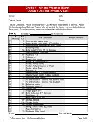
Map Scale - OUSD School-Finder - Oakland Unified School District
Map Scale - OUSD School-Finder - Oakland Unified School District
Map Scale - OUSD School-Finder - Oakland Unified School District

Create successful ePaper yourself
Turn your PDF publications into a flip-book with our unique Google optimized e-Paper software.
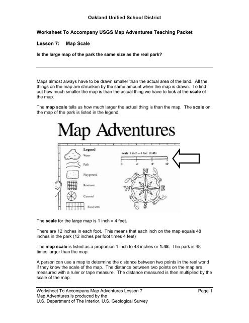
<strong>Oakland</strong> <strong>Unified</strong> <strong>School</strong> <strong>District</strong><br />
Worksheet To Accompany USGS <strong>Map</strong> Adventures Teaching Packet<br />
Lesson 7:<br />
<strong>Map</strong> <strong>Scale</strong><br />
Is the large map of the park the same size as the real park?<br />
<strong>Map</strong>s almost always have to be drawn smaller than the actual area of the land. All the<br />
things on the map are shrunken by the same amount when the map is drawn. To find<br />
out how much smaller the map is than the actual thing we have to look at the scale of<br />
the map.<br />
The map scale tells us how much larger the actual thing is than the map. The scale on<br />
the map of the park is listed in the legend.<br />
The scale for the large map is 1 inch = 4 feet.<br />
There are 12 inches in each foot. This means that each inch on the map equals 48<br />
inches in the park (12 inches per foot times 4 feet)<br />
The map scale is listed as a proportion 1 inch to 48 inches or 1:48. The park is 48<br />
times larger than the map.<br />
A person can use a map to determine the distance between two points in the real world<br />
if they know the scale of the map. The distance between two points on the map are<br />
measured with a ruler or tape measure. The distance measured is then multiplied by the<br />
scale of the map.<br />
Worksheet To Accompany <strong>Map</strong> Adventures Lesson 7 Page 1<br />
<strong>Map</strong> Adventures is produced by the<br />
U.S. Department of The Interior, U.S. Geological Survey
<strong>Oakland</strong> <strong>Unified</strong> <strong>School</strong> <strong>District</strong><br />
The stairs on the dinosaur slide are 7 inches from the center of the star. Each inch on<br />
the map equals 4 feet. The stairs of the slide in the actual park are 7 X 4 = 28 feet from<br />
the center of the star.<br />
What would something on the map look like if it were the same size as in the park?<br />
The drawing of the turtle sand box from the map has been blown up 4 times.<br />
The grid is made up of 1 inch squares. Use a ruler to draw a grid where each square is<br />
1 foot by 1 foot. You can draw your grid on a large piece of paper or with chalk on the<br />
sidewalk.<br />
Use the drawing as a model to make a full size picture of the turtle sandbox in the large<br />
grid that you have drawn.<br />
Worksheet To Accompany <strong>Map</strong> Adventures Lesson 7 Page 2<br />
<strong>Map</strong> Adventures is produced by the<br />
U.S. Department of The Interior, U.S. Geological Survey
<strong>Oakland</strong> <strong>Unified</strong> <strong>School</strong> <strong>District</strong><br />
Here is a copy of a map of <strong>Oakland</strong> around Lake Merritt . . The scale on this map is<br />
1:36,000.<br />
Worksheet To Accompany <strong>Map</strong> Adventures Lesson 7 Page 3<br />
<strong>Map</strong> Adventures is produced by the<br />
U.S. Department of The Interior, U.S. Geological Survey
<strong>Oakland</strong> <strong>Unified</strong> <strong>School</strong> <strong>District</strong><br />
Here is a copy of a map of the United States. Alaska and Hawaii are not shown on this<br />
map. One inch equals 400 miles. The scale is 1:26,808,452.<br />
The scale of a map tells you how much bigger the land area is than the picture on the<br />
map.<br />
The park is 48 times bigger than the map of the park.<br />
The part of <strong>Oakland</strong> around Lake Merritt is 36 thousand times larger than the map on the<br />
previous page.<br />
The United States is more than 26 million times bigger than the map on this page.<br />
Worksheet To Accompany <strong>Map</strong> Adventures Lesson 7 Page 4<br />
<strong>Map</strong> Adventures is produced by the<br />
U.S. Department of The Interior, U.S. Geological Survey
<strong>Oakland</strong> <strong>Unified</strong> <strong>School</strong> <strong>District</strong><br />
Think More About It<br />
1 2 3<br />
4 1<br />
4 inch ruler 1 inch ruler<br />
<strong>Map</strong> of<br />
Travel Chess Set<br />
Travel Chess Set<br />
Both the travel chess set and the map of the travel chess set are squares.<br />
How wide is the map of the travel chess set? _______________<br />
How wide is the travel chess set? _______________<br />
What is the scale of the map of the travel chess set?___________________<br />
Worksheet To Accompany <strong>Map</strong> Adventures Lesson 7 Page 5<br />
<strong>Map</strong> Adventures is produced by the<br />
U.S. Department of The Interior, U.S. Geological Survey
<strong>Oakland</strong> <strong>Unified</strong> <strong>School</strong> <strong>District</strong><br />
MAP CENTER Practice Session 6<br />
Let’s use MAP CENTER to review map scale.<br />
Getting To <strong>Map</strong> Center<br />
There are several ways to get to MAP CENTER on the world wide web. The fastest way<br />
from any computer is to type the address of the MAP CENTER computer in the Address<br />
box of your web browser.<br />
The address for MAP CENTER is<br />
http://mapstacker.ousd.k12.ca.us/welcome.htm.<br />
Most computers at <strong>District</strong> sites have the <strong>District</strong>’s web page as their home page. If you<br />
are already on the <strong>District</strong>’s home page, the easiest way<br />
to get to MAP CENTER is to click on the <strong>Map</strong> Center link<br />
in the FEATURES section.<br />
1<br />
1. Click on the Interactive <strong>Map</strong>s picture.<br />
2. Click on the Find a school: circle.<br />
3. Click on the down arrowhead.<br />
4. Find the name of your school.<br />
5. Click on the name of your school.<br />
2 3<br />
5<br />
4<br />
6<br />
6. Click on the Reference <strong>Map</strong> picture<br />
Worksheet To Accompany <strong>Map</strong> Adventures Lesson 7 Page 6<br />
<strong>Map</strong> Adventures is produced by the<br />
U.S. Department of The Interior, U.S. Geological Survey
<strong>Oakland</strong> <strong>Unified</strong> <strong>School</strong> <strong>District</strong><br />
MAP CENTER Practice Session 6 (continued)<br />
MAP CENTER displays a map with the school in the middle.<br />
The scale of the map is drawn in the bottom left corner of the map.<br />
1 inch on the map equals 606 feet around Hillcrest school.<br />
The area around Hillcrest school shown on the map is 7,269 times larger than the area<br />
shown on the map.<br />
The five maps that have been presented are listed in the table below. The maps are<br />
listed by scale. The map which is closest in size to the actual object it represents is<br />
listed first and the map which is the smallest in size compared to the actual object is<br />
listed last.<br />
<strong>Map</strong><br />
<strong>Scale</strong><br />
<strong>Map</strong> of Travel Chess Set 1:4<br />
Park <strong>Map</strong> From Nikki’s Adventure 1:48<br />
<strong>Map</strong> of Area Around Hillcrest <strong>School</strong> 1:7,269<br />
<strong>Map</strong> of <strong>Oakland</strong> around Lake Merritt 1:36,000<br />
<strong>Map</strong> of the Continental U.S.A. 1:26,808,452<br />
Worksheet To Accompany <strong>Map</strong> Adventures Lesson 7 Page 7<br />
<strong>Map</strong> Adventures is produced by the<br />
U.S. Department of The Interior, U.S. Geological Survey
<strong>Oakland</strong> <strong>Unified</strong> <strong>School</strong> <strong>District</strong><br />
MAP CENTER Practice Session 6 (continued)<br />
Paper maps have only one scale which does not change. You can request MAP<br />
CENTER maps at lots of different scales.<br />
! Click on the Zoom In Button.<br />
MAP CENTER displays a new map. The school is still at the center of the map. The<br />
map covers less area and the things on the map are shown in greater detail.<br />
1 inch on the map now only equals 454 feet.<br />
1 on the old map equaled 606 feet.<br />
You see less of the area around the school than you did in the last map. This is<br />
because the screen size is still the same, but the picture being drawn on the map is<br />
larger.<br />
Worksheet To Accompany <strong>Map</strong> Adventures Lesson 7 Page 8<br />
<strong>Map</strong> Adventures is produced by the<br />
U.S. Department of The Interior, U.S. Geological Survey
<strong>Oakland</strong> <strong>Unified</strong> <strong>School</strong> <strong>District</strong><br />
MAP CENTER Practice Session 6 (continued)<br />
! Click on the Show The August 1994 Air Photo Button.<br />
! Click on the Zoom In button 3 times.<br />
Wait for the picture to be redrawn between clicks.<br />
The picture is redrawn at a scale of 1 inch equals 192 feet.<br />
Notice that the picture of the school is much larger at this scale.<br />
Also notice that you can’t see all of the streets at this scale could on the 1:5,452 scale<br />
photo.<br />
Worksheet To Accompany <strong>Map</strong> Adventures Lesson 7 Page 9<br />
<strong>Map</strong> Adventures is produced by the<br />
U.S. Department of The Interior, U.S. Geological Survey