

gb 1978.book - Carolina Geological Society
gb 1978.book - Carolina Geological Society
gb 1978.book - Carolina Geological Society

You also want an ePaper? Increase the reach of your titles
YUMPU automatically turns print PDFs into web optimized ePapers that Google loves.
David C. Prowell<br />
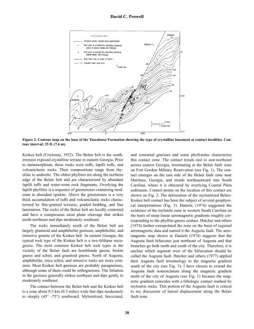
Figure 2. Contour map on the base of the Tuscaloosa Formation showing the type of crystalline basement at contact localities. Contour<br />
interval: 25 ft. (7.6 m).<br />
Kiokee belt (Crickmay, 1952). The Belair belt is the southernmost<br />
exposed crystalline terrane in eastern Georgia. Prior<br />
to metamorphism, these rocks were tuffs, lapilli tuffs, and<br />
volcaniclastic rocks. Their compositions range from rhyolitic<br />
to andesitic. The oldest phyllites are along the northern<br />
edge of the Belair belt and are characterized by abundant<br />
lapilli tuffs and water-worn rock fragments. Overlying the<br />
lapilli phyllites is a sequence of greenstones containing moderate<br />
to abundant epidote. Above the greenstones is a very<br />
thick accumulation of tuffs and volcaniclastic rocks characterized<br />
by fine-grained textures, graded bedding, and fine<br />
lamination. The rocks of the Belair belt are locally contorted<br />
and have a conspicuous axial plane cleavage that strikes<br />
north-northeast and dips moderately southeast.<br />
The rocks immediately north of the Belair belt are<br />
largely granitoid and amphibolite gneisses, amphibolite, and<br />
intrusive granite of the Kiokee belt. In eastern Georgia, the<br />
typical rock type of the Kiokee belt is a two-feldspar micagneiss.<br />
The most common Kiokee belt rock types in the<br />
vicinity of the Belair fault are hornblende gneiss, biotite<br />
gneiss and schist, and granitoid gneiss. North of Augusta,<br />
amphibolite, mica schist, and intrusive rocks are more common.<br />
Most Kiokee belt gneisses are probably paragneisses,<br />
although some of them could be orthogneisses. The foliation<br />
in the gneisses generally strikes northeast and dips gently to<br />
moderately southeast.<br />
The contact between the Belair belt and the Kiokee belt<br />
is a zone about 0.5 km (0.3 miles) wide that dips moderately<br />
to steeply (45° -75°) southward. Mylonitized, brecciated,<br />
and contorted gneisses and some phyllonites characterize<br />
this contact zone. The contact trends east to east-northeast<br />
across eastern Georgia, terminating at the Belair fault zone<br />
on Fort Gordon Military Reservation (see Fig. 1). The contact<br />
emerges on the east side of the Belair fault zone near<br />
Martinez, Georgia, and trends northeastward into South<br />
<strong>Carolina</strong>, where it is obscured by overlying Coastal Plain<br />
sediments. Control points on the location of this contact are<br />
shown on Fig. 2. The delineation of the mylonitized Belair-<br />
Kiokee belt contact has been the subject of several geophysical<br />
interpretations (Fig. 3). Daniels, (1974) suggested the<br />
existence of the mylonite zone in western South <strong>Carolina</strong> on<br />
the basis of steep linear aeromagnetic gradients roughly corresponding<br />
to the phyllite-gneiss contact. Hatcher and others<br />
(1974) further extrapolated the zone on the basis of regional<br />
aeromagnetic data and named it the Augusta fault. The aeromagnetic<br />
map shown in Daniels (1974) suggests that the<br />
Augusta fault bifurcates just northeast of Augusta and that<br />
branches go both north and south of the city. Therefore, it is<br />
unclear which segment west of the bifurcation should be<br />
called the Augusta fault. Hatcher and others (1977) applied<br />
their Augusta fault terminology to the magnetic gradient<br />
south of the city (see Fig. 3). I have chosen to extend the<br />
Augusta fault nomenclature along the magnetic gradient<br />
north of the city of Augusta (see Fig. 1) because the magnetic<br />
gradient coincides with a lithologic contact marked by<br />
mylonitic rocks. This portion of the Augusta fault is critical<br />
to my discussion of lateral displacement along the Belair<br />
fault zone.<br />
38


