Environmental Assessment of Ogoniland - Disasters and Conflicts ...
Environmental Assessment of Ogoniland - Disasters and Conflicts ...
Environmental Assessment of Ogoniland - Disasters and Conflicts ...

Create successful ePaper yourself
Turn your PDF publications into a flip-book with our unique Google optimized e-Paper software.
<strong>Environmental</strong><br />
<strong>Assessment</strong><br />
<strong>of</strong> <strong>Ogonil<strong>and</strong></strong><br />
United Nations Environment Programme
First published in 2011 by the United Nations Environment Programme.<br />
© 2011, United Nations Environment Programme.<br />
ISBN: 978-92-807-3130-9<br />
Job No.: DEP/1337/GE<br />
United Nations Environment Programme<br />
P.O. Box 30552<br />
Nairobi, KENYA<br />
Tel: +254 (0)20 762 1234<br />
Fax: +254 (0)20 762 3927<br />
E-mail: uneppub@unep.org<br />
Web: http://www.unep.org<br />
This publication may be reproduced in whole or in part <strong>and</strong> in any form for educational or non-pr<strong>of</strong>it purposes without special<br />
permission from the copyright holder provided acknowledgement <strong>of</strong> the source is made. UNEP would appreciate receiving a<br />
copy <strong>of</strong> any publication that uses this publication as a source. No use <strong>of</strong> this publication may be made for resale or for any other<br />
commercial purpose whatsoever without prior permission in writing from UNEP. The designation <strong>of</strong> geographical entities in this<br />
report, <strong>and</strong> the presentation <strong>of</strong> the material herein, do not imply the expression <strong>of</strong> any opinion whatsoever on the part <strong>of</strong> the<br />
publisher or the participating organisations concerning the legal status <strong>of</strong> any country, territory or area, or <strong>of</strong> its authorities, or<br />
concerning the delimination <strong>of</strong> its frontiers or boundaries.<br />
This publication <strong>and</strong> other data on which it is based are available online at: www.unep.org/nigeria<br />
Photography: Mazen Saggar <strong>and</strong> Victor Tem<strong>of</strong>e Mogbolu. Unless otherwise credited,<br />
all other photographs in this publication were taken by UNEP staff.<br />
Layout: Matija Potocnik<br />
Cover image: Victor Tem<strong>of</strong>e Mogbolu<br />
Printed on Recycled Paper<br />
UNEP promotes<br />
environmentally sound practices<br />
globally <strong>and</strong> in its own activities. This<br />
publication is printed on recycled paper<br />
using vegetable-based inks <strong>and</strong> other ec<strong>of</strong>riendly<br />
practices. Our distribution policy<br />
aims to reduce UNEP’s carbon footprint.
<strong>Environmental</strong><br />
<strong>Assessment</strong><br />
<strong>of</strong> <strong>Ogonil<strong>and</strong></strong><br />
United Nations Environment Programme
Table <strong>of</strong> contents<br />
Foreword 6<br />
Executive summary 8<br />
Chapter 1: Introduction 18<br />
1.1 Nigeria <strong>and</strong> the Niger Delta .................................................................................................................................20<br />
Rivers State ..........................................................................................................................................................22<br />
<strong>Ogonil<strong>and</strong></strong> ............................................................................................................................................................22<br />
1.2 Impacts <strong>of</strong> oil exploration <strong>and</strong> production............................................................................................................24<br />
1.3 The Ogoni struggle <strong>and</strong> the cessation <strong>of</strong> oil exploration <strong>and</strong> production...............................................................25<br />
1.4 Reconciliation process ..........................................................................................................................................26<br />
Chapter 2: Background to <strong>Environmental</strong> Degradation in <strong>Ogonil<strong>and</strong></strong> 28<br />
2.1 <strong>Environmental</strong> setting in <strong>Ogonil<strong>and</strong></strong> <strong>and</strong> the Niger Delta ....................................................................................30<br />
Geology ...............................................................................................................................................................30<br />
Groundwater ........................................................................................................................................................30<br />
Surface water ........................................................................................................................................................31<br />
Vegetation ............................................................................................................................................................32<br />
Local communities ...............................................................................................................................................32<br />
Ogoni interaction with neighbouring regions .......................................................................................................35<br />
Institutional framework........................................................................................................................................36<br />
2.2 Petroleum hydrocarbons: origin <strong>and</strong> environmental consequences .......................................................................36<br />
Origin <strong>and</strong> use .....................................................................................................................................................36<br />
<strong>Environmental</strong> consequences <strong>of</strong> hydrocarbons .....................................................................................................37<br />
Non-hydrocarbon environmental issues related to the oil industry .......................................................................41<br />
2.3 Oil industry-related infrastructure in <strong>Ogonil<strong>and</strong></strong> ..................................................................................................43<br />
SPDC facilities in <strong>Ogonil<strong>and</strong></strong> ...............................................................................................................................43<br />
Non-SPDC oil industry facilities in <strong>Ogonil<strong>and</strong></strong> ....................................................................................................46<br />
Chapter 3: Objectives, Scope <strong>and</strong> Methodologies 50<br />
3.1 Objectives ............................................................................................................................................................52<br />
3.2 Scope <strong>of</strong> the investigation .....................................................................................................................................52<br />
Geographical scope ..............................................................................................................................................52<br />
Technical scope <strong>of</strong> the assessment .........................................................................................................................53<br />
3.3 Structure <strong>of</strong> the study team ..................................................................................................................................53<br />
Project management .............................................................................................................................................54<br />
Technical teams ....................................................................................................................................................54<br />
Cross-cutting teams ..............................................................................................................................................55<br />
Support teams ......................................................................................................................................................55<br />
Use <strong>of</strong> local resources ...........................................................................................................................................58<br />
Laboratories .........................................................................................................................................................59<br />
3.4 <strong>Assessment</strong> methodologies ...................................................................................................................................59<br />
Community engagement ......................................................................................................................................61<br />
3.5 Phase 1: Scouting exercises, desktop reviews <strong>and</strong> reconnaissance ..........................................................................62<br />
3.6 Phase 2: Intensive fieldwork .................................................................................................................................64<br />
2
<strong>Assessment</strong> <strong>of</strong> soil contamination .........................................................................................................................64<br />
<strong>Assessment</strong> <strong>of</strong> groundwater contamination ...........................................................................................................66<br />
<strong>Assessment</strong> <strong>of</strong> naturally occurring radioactive materials ........................................................................................68<br />
<strong>Assessment</strong> <strong>of</strong> surface water <strong>and</strong> sediment contamination ....................................................................................68<br />
<strong>Assessment</strong> <strong>of</strong> fish contamination .........................................................................................................................70<br />
<strong>Assessment</strong> <strong>of</strong> impact <strong>of</strong> oil contaminants on vegetation ......................................................................................71<br />
<strong>Assessment</strong> <strong>of</strong> damage to mangroves .....................................................................................................................72<br />
<strong>Assessment</strong> <strong>of</strong> impacts on air pollution <strong>and</strong> public health .....................................................................................72<br />
Remote sensing ....................................................................................................................................................79<br />
Sample management ............................................................................................................................................81<br />
Field measurements ..............................................................................................................................................83<br />
Analytical measurements ......................................................................................................................................83<br />
Field data collection for remote sensing ................................................................................................................84<br />
Review <strong>of</strong> institutional issues ................................................................................................................................85<br />
3.7 Contamination assessment criteria .......................................................................................................................85<br />
St<strong>and</strong>ards for soil ..................................................................................................................................................86<br />
St<strong>and</strong>ards for groundwater ...................................................................................................................................87<br />
St<strong>and</strong>ards for drinking water ................................................................................................................................87<br />
Air quality st<strong>and</strong>ards ............................................................................................................................................88<br />
3.8 Limitations, challenges <strong>and</strong> constraints ................................................................................................................88<br />
Scientific constraints ............................................................................................................................................88<br />
Security constraints ..............................................................................................................................................90<br />
Access restrictions .................................................................................................................................................91<br />
Information constraints ........................................................................................................................................92<br />
Sample management constraints ..........................................................................................................................93<br />
Ill-defined boundaries ..........................................................................................................................................93<br />
Vertical delineation <strong>of</strong> contamination ...................................................................................................................93<br />
Time frame ..........................................................................................................................................................93<br />
Chapter 4: <strong>Assessment</strong> <strong>of</strong> Contaminated Soil <strong>and</strong> Groundwater 94<br />
4.1 Field observations <strong>of</strong> the current situation on l<strong>and</strong> ...............................................................................................96<br />
Habitation on or close to oilfield facilities ............................................................................................................96<br />
Unmanaged vegetation .........................................................................................................................................98<br />
Facilities not in operation .....................................................................................................................................98<br />
Decommissioned <strong>and</strong> ab<strong>and</strong>oned facilities ...........................................................................................................99<br />
Well blowouts ....................................................................................................................................................100<br />
4.2 Field observations concerning illegal oil-related activities ...................................................................................101<br />
Illegal tapping <strong>of</strong> oil wells <strong>and</strong> pipelines .............................................................................................................101<br />
Artisanal refining ................................................................................................................................................102<br />
4.3 Geological observations ......................................................................................................................................105<br />
Groundwater ......................................................................................................................................................105<br />
4.4 Contamination assessments ................................................................................................................................108<br />
Soil <strong>and</strong> groundwater contamination .................................................................................................................108<br />
Case study 1 SPDC pipeline right <strong>of</strong> way – 001-001 Ejama-Ebubu, Eleme LGA .............................................110<br />
Case study 2 SPDC suspended facilities – Bomu Manifold, K-Dere, Gokana LGA ..........................................115<br />
Case study 3 SPDC legacy site – 008-010 Korokoro flow station .....................................................................119<br />
Case study 4 NNPC trunk line spill – 019-013 1990 pipeline leak in K-Dere .................................................122<br />
<br />
3
Case study 5 NNPC product line spill – 001-005 Nsisioken Agbi, Eleme LGA ...............................................127<br />
Case study 6 Fly tipping <strong>of</strong> oilfield waste - 001-022 – oil waste dump site .......................................................130<br />
Case study 7 SPDC remediation site 008-002 – Korokoro Well 3, Korokoro, Tai LGA ...................................132<br />
Background concentration <strong>of</strong> hydrocarbons .......................................................................................................136<br />
Barium pollution................................................................................................................................................136<br />
Naturally occurring radioactive material (NORM) results ..................................................................................136<br />
4.5 Discussion <strong>of</strong> institutional issues ........................................................................................................................138<br />
Multiple institutions with unclear m<strong>and</strong>ates .......................................................................................................138<br />
Resolving the issue .............................................................................................................................................142<br />
Review <strong>of</strong> SPDC’s practices <strong>and</strong> performance .....................................................................................................142<br />
SPDC operational practice at oil spill sites .........................................................................................................150<br />
Chapter 5: <strong>Assessment</strong> <strong>of</strong> Vegetation, Aquatic <strong>and</strong> Public Health Issues 152<br />
5.1 Impact <strong>of</strong> oil on tide-dominated delta swamps <strong>and</strong> mangroves ...........................................................................154<br />
Case study 8 Artisanal refining <strong>of</strong> crude oil at 020-001 Bodo West oilfield, flow station <strong>and</strong> manifold .............161<br />
5.2 Impact <strong>of</strong> oil on l<strong>and</strong>-based vegetation ...............................................................................................................167<br />
5.3 Contamination <strong>of</strong> surface water, sediments <strong>and</strong> fish ...........................................................................................169<br />
Presence <strong>of</strong> oil ....................................................................................................................................................169<br />
Water quality .....................................................................................................................................................169<br />
Petroleum hydrocarbons in water .......................................................................................................................173<br />
Impacts <strong>of</strong> oil on sediments ................................................................................................................................175<br />
Impacts <strong>of</strong> oil on fisheries ...................................................................................................................................175<br />
5.4 Impacts <strong>of</strong> oil on public health ...........................................................................................................................183<br />
Exposure <strong>and</strong> health questionnaires ....................................................................................................................183<br />
Case study 9 Groundwater pollution at Nsisioken Ogale, Eleme LGA .............................................................189<br />
<strong>Ogonil<strong>and</strong></strong> is not an isl<strong>and</strong> .................................................................................................................................200<br />
Chapter 6: Recommendations 102<br />
6.1 Operational recommendations ...........................................................................................................................205<br />
Maintenance <strong>of</strong> oilfield facilities .........................................................................................................................205<br />
Decommissioning <strong>of</strong> oilfield facilities .................................................................................................................205<br />
Prevention <strong>of</strong> illegal activities .............................................................................................................................205<br />
Oil spill response ................................................................................................................................................206<br />
Ongoing remediation <strong>of</strong> contaminated sites .......................................................................................................206<br />
6.2 Technical recommendations for environmental restoration.................................................................................207<br />
Clean-up <strong>of</strong> contaminated soil <strong>and</strong> sediments ....................................................................................................207<br />
Decontamination <strong>of</strong> groundwater ......................................................................................................................210<br />
Rehabilitation <strong>of</strong> mangroves ...............................................................................................................................211<br />
6.3 Recommendations for public health ...................................................................................................................214<br />
Communities exposed to petroleum hydrocarbons in their drinking water .........................................................214<br />
Communities living on rights <strong>of</strong> way .................................................................................................................215<br />
People involved in bunkering <strong>and</strong> artisanal refining ............................................................................................215<br />
6.4 Recommendations on follow-up monitoring ......................................................................................................215<br />
Preventive surveillance........................................................................................................................................216<br />
Monitoring <strong>of</strong> groundwater ................................................................................................................................217<br />
Monitoring <strong>of</strong> water bodies, fish <strong>and</strong> aquatic sediments .....................................................................................217<br />
Monitoring <strong>of</strong> vegetation <strong>and</strong> fauna ...................................................................................................................217<br />
4
Air quality monitoring .......................................................................................................................................217<br />
Public health monitoring ...................................................................................................................................217<br />
6.5 Recommendations for changes to regulatory framework.....................................................................................217<br />
Legislative matters ..............................................................................................................................................217<br />
Institutional arrangements..................................................................................................................................219<br />
6.6 Recommendations for follow-up ........................................................................................................................219<br />
Chapter 7: <strong>Ogonil<strong>and</strong></strong>’s Path to Sustainability 222<br />
7.1 Recommendations for Government ...................................................................................................................224<br />
Creation <strong>of</strong> an <strong>Ogonil<strong>and</strong></strong> <strong>Environmental</strong> Restoration Authority .......................................................................224<br />
Creating an <strong>Environmental</strong> Restoration Fund for <strong>Ogonil<strong>and</strong></strong> .............................................................................226<br />
Creating a Centre <strong>of</strong> Excellence for <strong>Environmental</strong> Restoration .........................................................................227<br />
Declare the intent to make the wetl<strong>and</strong>s around <strong>Ogonil<strong>and</strong></strong> a Ramsar site..........................................................228<br />
Mount a campaign against environmental degradation.......................................................................................228<br />
7.2 Recommendations for oil industry operators ......................................................................................................228<br />
7.3 Recommendations for the <strong>Ogonil<strong>and</strong></strong> community .............................................................................................229<br />
7.4 Interim actions to move forward ........................................................................................................................229<br />
7.5 Transition Phase .................................................................................................................................................231<br />
Appendices<br />
Appendix 1: Acronyms <strong>and</strong> abbreviations .................................................................................................................234<br />
Appendix 2: Glossary ................................................................................................................................................236<br />
Appendix 3: References .............................................................................................................................................240<br />
Appendix 4: Collaborating partners ..........................................................................................................................245<br />
Appendix 5: List <strong>of</strong> contributors ...............................................................................................................................246<br />
<br />
5
Foreword<br />
The history <strong>of</strong> oil exploration <strong>and</strong> production in<br />
<strong>Ogonil<strong>and</strong></strong> is a long, complex <strong>and</strong> <strong>of</strong>ten painful<br />
one that to date has become seemingly intractable<br />
in terms <strong>of</strong> its resolution <strong>and</strong> future direction.<br />
It is also a history that has put people <strong>and</strong> politics<br />
<strong>and</strong> the oil industry at loggerheads rendering a<br />
l<strong>and</strong>scape characterized by a lack <strong>of</strong> trust, paralysis<br />
<strong>and</strong> blame, set against a worsening situation for<br />
the communities concerned.<br />
The reality is that decades <strong>of</strong> negotiations,<br />
initiatives <strong>and</strong> protests have ultimately failed to<br />
deliver a solution that meets the expectations <strong>and</strong><br />
responsibilities <strong>of</strong> all sides.<br />
In an attempt to navigate from stalemate to action,<br />
the Government <strong>of</strong> Nigeria, in consultation with<br />
many <strong>of</strong> the relevant actors, invited UNEP<br />
to consider undertaking an assessment <strong>of</strong> oil<br />
pollution in <strong>Ogonil<strong>and</strong></strong>.<br />
UNEP has acquired an international reputation<br />
for assembling expert teams, coordinating<br />
dem<strong>and</strong>ing assessments <strong>and</strong> bringing scientific<br />
<strong>and</strong> empirical evidence to policymakers.<br />
UNEP initially consulted with a wide range<br />
stakeholders <strong>and</strong> the United Nations Country<br />
Team in Nigeria in order to consider the scope<br />
<strong>and</strong> indeed the feasibility <strong>of</strong> the assessment.<br />
We were confronted with a unique challenge:<br />
lack <strong>of</strong> trust between actors; political tensions<br />
between communities; regional <strong>and</strong> national<br />
government; gaining access to <strong>Ogonil<strong>and</strong></strong>; security<br />
considerations <strong>and</strong> technical <strong>and</strong> logistical<br />
challenges.<br />
Despite imperfect conditions, UNEP in the end<br />
agreed to undertake the study as it represented<br />
the only tangible option for possibly breaking<br />
the decades <strong>of</strong> deadlock while providing the<br />
government <strong>and</strong> stakeholders with a potential<br />
foundation upon which trust might be built <strong>and</strong><br />
action undertaken to remedy the multiple health,<br />
environmental <strong>and</strong> sustainable development<br />
issues facing millions <strong>of</strong> people in <strong>Ogonil<strong>and</strong></strong><br />
<strong>and</strong> beyond.<br />
In order to ensure the independence <strong>of</strong> the study<br />
<strong>and</strong> provide the logistics necessary, a framework<br />
for cooperation was negotiated in which all parties<br />
were involved <strong>and</strong> a recognized team <strong>of</strong> national<br />
<strong>and</strong> international experts then recruited for the<br />
two year assessment.<br />
This report details how that team carried out<br />
their work, where samples were taken <strong>and</strong><br />
the findings that they have made. Over a<br />
14-month period, the UNEP team examined<br />
more than 200 locations, surveyed 122 kms<br />
<strong>of</strong> pipeline rights <strong>of</strong> way, reviewed more than<br />
5,000 medical records <strong>and</strong> engaged over 23,000<br />
people at local community meetings. Detailed<br />
soil contamination investigations were conducted<br />
at 69 sites. Altogether more than 4,000 samples<br />
were analyzed, including water taken from 142<br />
groundwater monitoring wells drilled specifically<br />
for the study <strong>and</strong> soil extracted from 780<br />
boreholes.<br />
The findings in the report underline that there<br />
are, in a significant number <strong>of</strong> locations, serious<br />
threats to human health from contaminated<br />
drinking water to concerns over the viability<br />
<strong>and</strong> productivity <strong>of</strong> ecosystems. In addition<br />
that pollution has perhaps gone further <strong>and</strong><br />
penetrated deeper than many may have previously<br />
supposed.<br />
This report represents the best available underst<strong>and</strong>ing<br />
as to what has happened to the environment <strong>of</strong><br />
<strong>Ogonil<strong>and</strong></strong> – <strong>and</strong> the corresponding implications<br />
for affected populations – over many years <strong>of</strong> oil<br />
industry operations. It provides the government,<br />
stakeholders <strong>and</strong> the international community<br />
with invaluable, baseline information on the scale<br />
<strong>of</strong> the challenge <strong>and</strong> priorities for action in terms<br />
<strong>of</strong> clean-up <strong>and</strong> remediation.<br />
It does not address all scenarios <strong>and</strong> answer<br />
all questions which have arisen over the years,<br />
particularly in respect to legal questions which<br />
were beyond the terms <strong>of</strong> reference <strong>of</strong> the<br />
undertaking.<br />
But UNEP believes it can provide a firm foundation<br />
upon which all the stakeholders concerned can, if<br />
6
they so wish, draw up a response to the findings<br />
presented here.<br />
Before <strong>and</strong> during the assessment, the consensus<br />
that has allowed this work to proceed in the first<br />
place was at times fluid <strong>and</strong> sometimes fractious<br />
<strong>and</strong> fragile. Many questions were raised, not least<br />
surrounding how the study was financed <strong>and</strong> by<br />
whom. The report <strong>and</strong> its long list <strong>of</strong> annexes<br />
needs to speak for itself.<br />
But it is important to point out that from the<br />
outset UNEP deemed it right <strong>and</strong> appropriate<br />
that key actors in the petroleum sector should<br />
bear the financial costs for this assessment <strong>and</strong><br />
this was spelt out in the project document which<br />
is publicly available.<br />
To date all parties have honoured those<br />
commitments <strong>and</strong> the rigor, independence <strong>and</strong><br />
impartiality <strong>of</strong> the study <strong>and</strong> its conclusions has<br />
been maintained which we hereby acknowledge.<br />
This study would not have been possible without<br />
the local knowledge <strong>and</strong> cooperation <strong>of</strong> the Ogoni<br />
people <strong>and</strong> the support <strong>of</strong> many other stakeholders<br />
in Nigeria. We wish to sincerely thank the<br />
members <strong>of</strong> the Presidential Implementation<br />
Committee, under the Chairmanship <strong>of</strong> The<br />
Most Reverend Matthew Kukah, Bishop for the<br />
Diocese <strong>of</strong> Sokoto; the former Federal Minister<br />
for the Environment, The Hononourable John<br />
Odey; the traditional rulers <strong>of</strong> <strong>Ogonil<strong>and</strong></strong>, in<br />
particular the Paramount Ruler, His Majesty King<br />
Godwin N.K. Gininwa; the Executive Governor<br />
<strong>of</strong> Rivers State, the Right Honourable Rotimi<br />
Chibuike Amaechi, along with the faculty <strong>and</strong><br />
students at the Rivers State University <strong>of</strong> Science<br />
<strong>and</strong> Technology led by Vice Chancellor Pr<strong>of</strong>essor<br />
Barineme Beke Fakae.<br />
We also appreciate the assistance <strong>of</strong> our colleagues<br />
at the UN Nigeria Country Team, in particular<br />
the UN Resident Coordinator, Mr Daouda Touré,<br />
the Country Director <strong>of</strong> the United Nations<br />
Development Programme, Ms Ade Mamonyane<br />
Lekoetje, <strong>and</strong> the Resident Representative <strong>and</strong><br />
Resident Security Coordinator in Port Harcourt,<br />
Mr Larry Boms.<br />
I would also like to thank the national <strong>and</strong><br />
international members <strong>of</strong> the assessment team<br />
including UNEP staff members.<br />
For the first time, there is systematic <strong>and</strong> scientific<br />
evidence available in the public arena on the<br />
nature, extent <strong>and</strong> impacts <strong>of</strong> oil contamination<br />
in <strong>Ogonil<strong>and</strong></strong>. The report also provides clear<br />
operational guidelines as to how that legacy can<br />
be addressed.<br />
The oil industry has been a key sector <strong>of</strong> the<br />
Nigerian economy for over 50 years. But many<br />
Nigerians have paid a high price, as this assessment<br />
underlines. It is UNEP’s hope that the findings can<br />
catalyze not only significant environmental <strong>and</strong><br />
social improvements in the region but a strategic<br />
policy on how the oil industry there will function<br />
in a way that truly benefits the lives <strong>and</strong> livelihoods<br />
<strong>of</strong> these communities now <strong>and</strong> in the future.<br />
Achim Steiner<br />
United Nations Under-Secretary-General<br />
Executive Director<br />
<strong>of</strong> the United Nations Environment Programme<br />
<br />
7
UNEP<br />
ENVIRONMENTAL ASSESSMENT OF OGONILAND<br />
Executive Summary<br />
Introduction<br />
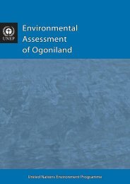
Covering around 1,000 km 2 in Rivers State,<br />
southern Nigeria, <strong>Ogonil<strong>and</strong></strong> has been the site<br />
<strong>of</strong> oil industry operations since the late 1950s.<br />
<strong>Ogonil<strong>and</strong></strong> has a tragic history <strong>of</strong> pollution from<br />
oil spills <strong>and</strong> oil well fires, although no systematic<br />
scientific information has been available about the<br />
ensuing contamination.<br />
With this independent study, conducted at the<br />
request <strong>of</strong> the Federal Government <strong>of</strong> Nigeria, the<br />
United Nations Environment Programme (UNEP)<br />
reveals the nature <strong>and</strong> extent <strong>of</strong> oil contamination<br />
in <strong>Ogonil<strong>and</strong></strong>.<br />
The <strong>Environmental</strong> <strong>Assessment</strong> <strong>of</strong> <strong>Ogonil<strong>and</strong></strong> covers<br />
contaminated l<strong>and</strong>, groundwater, surface water,<br />
sediment, vegetation, air pollution, public health,<br />
industry practices <strong>and</strong> institutional issues.<br />
This report represents the best available underst<strong>and</strong>ing<br />
<strong>of</strong> what has happened to the environment<br />
<strong>of</strong> <strong>Ogonil<strong>and</strong></strong> – <strong>and</strong> the corresponding implications<br />
for affected populations – <strong>and</strong> provides clear<br />
operational guidance as to how that legacy can be<br />
addressed.<br />
<strong>Assessment</strong> process<br />
Involving desk review, fieldwork <strong>and</strong> laboratory<br />
analysis, the two year study <strong>of</strong> the environmental<br />
<strong>and</strong> public health impacts <strong>of</strong> oil contamination<br />
in <strong>Ogonil<strong>and</strong></strong> is one <strong>of</strong> the most complex on-theground<br />
assessments ever undertaken by UNEP.<br />
UNEP recruited a team <strong>of</strong> international experts<br />
in disciplines such as contaminated l<strong>and</strong>, water,<br />
forestry <strong>and</strong> public health, who worked under<br />
the guidance <strong>of</strong> senior UNEP managers. This<br />
team worked side-by-side with local experts,<br />
academics <strong>and</strong> support teams comprised <strong>of</strong><br />
logistics, community liaison <strong>and</strong> security staff.<br />
The UNEP project team surveyed 122 kms <strong>of</strong><br />
pipeline rights <strong>of</strong> way <strong>and</strong> visited all oil spill sites,<br />
oil wells <strong>and</strong> other oil-related facilities in <strong>Ogonil<strong>and</strong></strong>,<br />
including decommissioned <strong>and</strong> ab<strong>and</strong>oned facilities,<br />
that were known <strong>and</strong> accessible to UNEP during the<br />
fieldwork period, based on information provided<br />
by the Government regulators, Shell Petroleum<br />
Development Company (Nigeria) Ltd (SPDC) <strong>and</strong><br />
community members in <strong>and</strong> around <strong>Ogonil<strong>and</strong></strong>.<br />
Public meetings staged throughout <strong>Ogonil<strong>and</strong></strong> during each phase <strong>of</strong> the study helped<br />
to build underst<strong>and</strong>ing <strong>of</strong> UNEP’s project <strong>and</strong> to foster community participation<br />
8
EXECUTIVE SUMMARY<br />
During aerial reconnaissance missions, UNEP<br />
experts observed oil pollution which was not readily<br />
visible from the ground, including artisanal refining<br />
sites. Information provided by <strong>Ogonil<strong>and</strong></strong> residents<br />
about oil contamination in their communities<br />
supplemented <strong>of</strong>ficial oil spill data supplied by the<br />
Nigerian Government <strong>and</strong> SPDC.<br />
Following its initial investigations, UNEP<br />
identified 69 sites for detailed soil <strong>and</strong> groundwater<br />
investigations. In addition, samples <strong>of</strong> community<br />
drinking water, sediments from creeks, surface<br />
water, rainwater, fish <strong>and</strong> air were collected<br />
throughout <strong>Ogonil<strong>and</strong></strong> <strong>and</strong> in several neighbouring<br />
areas. Altogether more than 4,000 samples were<br />
analyzed, including water drawn from 142<br />
groundwater monitoring wells drilled specifically<br />
for the study, <strong>and</strong> soil extracted from 780 boreholes.<br />
The UNEP project team also examined more than<br />
5,000 medical records <strong>and</strong> staged 264 formal<br />
community meetings in <strong>Ogonil<strong>and</strong></strong> attended by<br />
over 23,000 people.<br />
The samples were collected following internationallyaccepted<br />
sample management procedures <strong>and</strong><br />
dispatched for analysis to accredited (ISO 17025)<br />
laboratories in Europe. The analytes examined in the<br />
study included certain groups <strong>of</strong> hydrocarbons that<br />
are known to have adverse impacts <strong>and</strong> which are<br />
therefore dealt with selectively in oil-spill assessment<br />
<strong>and</strong> clean-up work. The most important <strong>of</strong> these are<br />
BTEX (benzene, toluene, ethylbenzene <strong>and</strong> xylenes)<br />
<strong>and</strong> PAHs (polycyclic aromatic hydrocarbons).<br />
Volatile organic compounds (VOCs) were the main<br />
target <strong>of</strong> UNEP’s air quality investigations.<br />
Extensive remote sensing analyses complemented<br />
the fieldwork. Reviews <strong>of</strong> legislation, institutions,<br />
oil industry practices <strong>and</strong> available remediation<br />
technologies were also undertaken by international<br />
experts to complete the study.<br />
A selection <strong>of</strong> the study’s key findings <strong>and</strong> recommendations<br />
are summarized below. Given the vast<br />
amount <strong>of</strong> data generated during the assessment,<br />
the following content should not be considered in<br />
isolation.<br />
Summary <strong>of</strong> findings<br />
UNEP’s field observations <strong>and</strong> scientific<br />
investigations found that oil contamination in<br />
<strong>Ogonil<strong>and</strong></strong> is widespread <strong>and</strong> severely impacting<br />
many components <strong>of</strong> the environment. Even<br />
though the oil industry is no longer active in<br />
<strong>Ogonil<strong>and</strong></strong>, oil spills continue to occur with<br />
alarming regularity. The Ogoni people live with<br />
this pollution every day.<br />
As <strong>Ogonil<strong>and</strong></strong> has high rainfall, any delay in<br />
cleaning up an oil spill leads to oil being washed<br />
away, traversing farml<strong>and</strong> <strong>and</strong> almost always ending<br />
up in the creeks. When oil reaches the root zone,<br />
crops <strong>and</strong> other plants begin to experience stress<br />
<strong>and</strong> can die, <strong>and</strong> this is a routine observation in<br />
<strong>Ogonil<strong>and</strong></strong>. At one site, Ejama-Ebubu in Eleme<br />
local government area (LGA), the study found<br />
heavy contamination present 40 years after an oil<br />
spill occurred, despite repeated clean-up attempts.<br />
The assessment found that overlapping authorities<br />
<strong>and</strong> responsibilities between ministries <strong>and</strong> a<br />
lack <strong>of</strong> resources within key agencies has serious<br />
implications for environmental management onthe-ground,<br />
including enforcement.<br />
Remote sensing revealed the rapid proliferation in<br />
the past two years <strong>of</strong> artisanal refining, whereby<br />
crude oil is distilled in makeshift facilities. The study<br />
found that this illegal activity is endangering lives<br />
<strong>and</strong> causing pockets <strong>of</strong> environmental devastation<br />
in <strong>Ogonil<strong>and</strong></strong> <strong>and</strong> neighbouring areas.<br />
Contaminated soil <strong>and</strong> groundwater<br />
The report concludes that pollution <strong>of</strong> soil<br />
by petroleum hydrocarbons in <strong>Ogonil<strong>and</strong></strong><br />
is extensive in l<strong>and</strong> areas, sediments <strong>and</strong><br />
swampl<strong>and</strong>. Most <strong>of</strong> the contamination is from<br />
crude oil although contamination by refined<br />
product was found at three locations.<br />
The assessment found there is no continuous<br />
clay layer across <strong>Ogonil<strong>and</strong></strong>, exposing the<br />
groundwater in <strong>Ogonil<strong>and</strong></strong> (<strong>and</strong> beyond) to<br />
hydrocarbons spilled on the surface. In 49 cases,<br />
UNEP observed hydrocarbons in soil at depths <strong>of</strong><br />
at least 5 m. This finding has major implications<br />
for the type <strong>of</strong> remediation required.<br />
At two-thirds <strong>of</strong> the contaminated l<strong>and</strong> sites<br />
close to oil industry facilities which were<br />
assessed in detail, the soil contamination<br />
exceeds Nigerian national st<strong>and</strong>ards, as set<br />
out in the <strong>Environmental</strong> Guidelines <strong>and</strong><br />
<br />
9
UNEP<br />
ENVIRONMENTAL ASSESSMENT OF OGONILAND<br />
St<strong>and</strong>ards for the Petroleum Industries in<br />
Nigeria (EGASPIN).<br />
At 41 sites, the hydrocarbon pollution has<br />
reached the groundwater at levels in excess <strong>of</strong><br />
the Nigerian st<strong>and</strong>ards as per the EGASPIN<br />
legislation.<br />
The most serious case <strong>of</strong> groundwater contamination<br />
is at Nisisioken Ogale, in Eleme LGA,<br />
close to a Nigerian National Petroleum Company<br />
product pipeline where an 8 cm layer <strong>of</strong> refined<br />
oil was observed floating on the groundwater<br />
which serves the community wells.<br />
Vegetation<br />
Oil pollution in many intertidal creeks has left<br />
mangroves denuded <strong>of</strong> leaves <strong>and</strong> stems, leaving<br />
roots coated in a bitumen-like substance<br />
sometimes 1 cm or more thick. Mangroves<br />
are spawning areas for fish <strong>and</strong> nurseries for<br />
juvenile fish <strong>and</strong> the extensive pollution <strong>of</strong> these<br />
areas is impacting the fish life-cycle.<br />
Any crops in areas directly impacted by oil<br />
spills will be damaged, <strong>and</strong> root crops, such as<br />
cassava, will become unusable. When farming<br />
recommences, plants generally show signs <strong>of</strong><br />
stress <strong>and</strong> yields are reportedly lower than in<br />
non-impacted areas.<br />
When an oil spill occurs on l<strong>and</strong>, fires <strong>of</strong>ten<br />
break out, killing vegetation <strong>and</strong> creating a<br />
crust over the l<strong>and</strong>, making remediation or<br />
revegetation difficult.<br />
Channels that have been widened <strong>and</strong> the<br />
resulting dredged material are clearly evident<br />
in satellite images, decades after the dredging<br />
operation. Without proper rehabilitation, former<br />
mangrove areas which have been converted to<br />
bare ground are being colonized by invasive<br />
species such as nipa palm (which appears to be<br />
more resistant to heavy hydrocarbon pollution<br />
than native vegetation).<br />
In Bodo West, in Bonny LGA, an increase<br />
in artisanal refining between 2007 <strong>and</strong> 2011<br />
has been accompanied by a 10% loss <strong>of</strong><br />
healthy mangrove cover, or 307,381 m 2 . If left<br />
unchecked, this may lead to irreversible loss <strong>of</strong><br />
mangrove habitat in this area.<br />
Aquatic<br />
The UNEP investigation found that the<br />
surface water throughout the creeks contains<br />
hydrocarbons. Floating layers <strong>of</strong> oil vary from<br />
thick black oil to thin sheens. The highest reading<br />
<strong>of</strong> dissolved hydrocarbon in the water column,<br />
<strong>of</strong> 7,420 μg/l, was detected at Ataba-Otokroma,<br />
bordering the Gokana <strong>and</strong> Andoni LGAs.<br />
Fish tend to leave polluted areas in search <strong>of</strong><br />
cleaner water, <strong>and</strong> fishermen must therefore<br />
also move to less contaminated areas in search<br />
<strong>of</strong> fish. When encountered in known polluted<br />
areas, fishermen reported that they were<br />
going to fishing grounds further upstream or<br />
downstream.<br />
Despite community concerns about the quality<br />
<strong>of</strong> fish, the results show that the accumulation<br />
<strong>of</strong> hydrocarbons in fish is not a serious health<br />
issue in <strong>Ogonil<strong>and</strong></strong> but that the fisheries sector<br />
is suffering due to the destruction <strong>of</strong> fish<br />
habitat in the mangroves <strong>and</strong> highly persistent<br />
contamination <strong>of</strong> many <strong>of</strong> the creeks, making<br />
them unsuitable for fishing.<br />
Where a number <strong>of</strong> entrepreneurs had set<br />
up fish farms in or close to the creeks, their<br />
businesses have been ruined by an ever-present<br />
layer <strong>of</strong> floating oil.<br />
The wetl<strong>and</strong>s around <strong>Ogonil<strong>and</strong></strong> are highly<br />
degraded <strong>and</strong> facing disintegration. The study<br />
concludes that while it is technically feasible to<br />
restore effective ecosystem functioning <strong>of</strong> the<br />
wetl<strong>and</strong>s, this will only be possible if technical<br />
<strong>and</strong> political initiatives are undertaken.<br />
Public health<br />
The Ogoni community is exposed to petroleum<br />
hydrocarbons in outdoor air <strong>and</strong> drinking<br />
water, sometimes at elevated concentrations.<br />
They are also exposed through dermal contacts<br />
from contaminated soil, sediments <strong>and</strong> surface<br />
water.<br />
Since average life expectancy in Nigeria is less<br />
than 50 years, it is a fair assumption that most<br />
members <strong>of</strong> the current <strong>Ogonil<strong>and</strong></strong> community<br />
have lived with chronic oil pollution throughout<br />
their lives.<br />
10
EXECUTIVE SUMMARY<br />
Contaminated river at Sugi Bodo, Gokana LGA. The report provides baseline information on the scale<br />
<strong>of</strong> the challenge for <strong>Ogonil<strong>and</strong></strong> <strong>and</strong> priorities for action in terms <strong>of</strong> clean-up <strong>and</strong> remediation<br />
Of most immediate concern, community<br />
members at Nisisioken Ogale are drinking<br />
water from wells that is contaminated with<br />
benzene, a known carcinogen, at levels over 900<br />
times above the World Health Organization<br />
(WHO) guideline. The report states that this<br />
contamination warrants emergency action<br />
ahead <strong>of</strong> all other remediation efforts.<br />
Hydrocarbon contamination was found in<br />
water taken from 28 wells at 10 communities<br />
adjacent to contaminated sites. At seven wells<br />
the samples are at least 1,000 times higher than<br />
the Nigerian drinking water st<strong>and</strong>ard <strong>of</strong> 3 μg/l.<br />
Local communities are aware <strong>of</strong> the pollution<br />
<strong>and</strong> its dangers but state that they continue to<br />
use the water for drinking, bathing, washing<br />
<strong>and</strong> cooking as they have no alternative.<br />
Benzene was detected in all air samples at<br />
concentrations ranging from 0.155 to 48.2<br />
μg/m 3 . Approximately 10 per cent <strong>of</strong> detected<br />
benzene concentrations in <strong>Ogonil<strong>and</strong></strong> were<br />
higher than the concentrations WHO <strong>and</strong><br />
the United States <strong>Environmental</strong> Protection<br />
Agency (USEPA) report as corresponding to a<br />
1 in 10,000 cancer risk. Many <strong>of</strong> the benzene<br />
concentrations detected in <strong>Ogonil<strong>and</strong></strong> were<br />
similar to those measured elsewhere in the<br />
world, given the prevalence <strong>of</strong> fuel use <strong>and</strong> other<br />
sources <strong>of</strong> benzene. However, the findings show<br />
that some benzene concentrations in <strong>Ogonil<strong>and</strong></strong><br />
were higher than those being measured in more<br />
economically developed regions where benzene<br />
concentrations are declining because <strong>of</strong> efforts<br />
to reduce benzene exposure.<br />
Institutional issues<br />
First issued in 1992, the EGASPIN form the<br />
operational basis for environmental regulation<br />
<strong>of</strong> the oil industry in Nigeria. However, this<br />
key legislation is internally inconsistent with<br />
regard to one <strong>of</strong> the most important criteria for<br />
oil spill <strong>and</strong> contaminated site management –<br />
specifically the criteria which trigger remediation<br />
or indicate its closure (called the ‘intervention’<br />
<strong>and</strong> ‘target’ values respectively).<br />
<br />
11
UNEP<br />
ENVIRONMENTAL ASSESSMENT OF OGONILAND<br />
The study found that the Department <strong>of</strong><br />
Petroleum Resources (DPR) <strong>and</strong> the National<br />
Oil Spill Detection <strong>and</strong> Response Agency<br />
(NOSDRA) have differing interpretations <strong>of</strong><br />
EGASPIN. This is enabling the oil industry to<br />
close down the remediation process well before<br />
contamination has been eliminated <strong>and</strong> soil<br />
quality has been restored to achieve functionality<br />
for human, animal <strong>and</strong> plant life.<br />
The Nigerian Government agencies concerned<br />
lack qualified technical experts <strong>and</strong> resources.<br />
In the five years since NOSDRA was<br />
established, so few resources have been<br />
allocated that the agency has no proactive<br />
capacity for oil-spill detection. In planning<br />
their inspection visits to some oil spill sites,<br />
the regulatory authority is wholly reliant on<br />
the oil industry for logistical support.<br />
The oilfield in <strong>Ogonil<strong>and</strong></strong> is interwoven<br />
with the Ogoni community. The fact that<br />
communities have set up houses <strong>and</strong> farms<br />
along rights <strong>of</strong> way is one indicator <strong>of</strong> the loss<br />
<strong>of</strong> control on the part <strong>of</strong> the pipeline operator<br />
<strong>and</strong> the government regulator.<br />
The UNEP project team observed hundreds<br />
<strong>of</strong> industrial packing bags containing 1,000-<br />
1,500 m 3 <strong>of</strong> waste, believed to be cuttings<br />
from oil drilling operations, dumped at a<br />
former s<strong>and</strong> mine in Oken Oyaa in Eleme<br />
LGA. The open disposal <strong>of</strong> such waste in<br />
an unlined pit demonstrates that the chain<br />
<strong>of</strong> custody in the region between the waste<br />
generator, transporter <strong>and</strong> disposal facility is<br />
not being followed.<br />
Oil industry practices<br />
The study concludes that the control,<br />
maintenance <strong>and</strong> decommissioning <strong>of</strong> oilfield<br />
infrastructure in <strong>Ogonil<strong>and</strong></strong> are inadequate.<br />
Industry best practices <strong>and</strong> SPDC’s own<br />
procedures have not been applied, creating<br />
public safety issues.<br />
Remediation by enhanced natural attenuation<br />
(RENA) – so far the only remediation method<br />
observed by UNEP in <strong>Ogonil<strong>and</strong></strong> – has not<br />
proven to be effective. Currently, SPDC applies<br />
this technique on the l<strong>and</strong> surface layer only, based<br />
on the assumption that given the nature <strong>of</strong> the<br />
oil, temperature <strong>and</strong> an underlying layer <strong>of</strong> clay,<br />
hydrocarbons will not move deeper. However, this<br />
basic premise is not sustainable as observations<br />
made by UNEP show that contamination can<br />
<strong>of</strong>ten penetrate deeper than 5 m <strong>and</strong> has reached<br />
the groundwater in many locations.<br />
Ten out <strong>of</strong> the 15 investigated sites which<br />
SPDC records show as having completed<br />
remediation, still have pollution exceeding<br />
the SPDC (<strong>and</strong> government) remediation<br />
closure values. The study found that the<br />
contamination at eight <strong>of</strong> these sites has<br />
migrated to the groundwater.<br />
In January 2010, a new Remediation<br />
Management System was adopted by all Shell<br />
Exploration <strong>and</strong> Production Companies in<br />
Nigeria. The study found that while the new<br />
changes are an improvement, they still do<br />
not meet the local regulatory requirements or<br />
international best practices.<br />
Summary <strong>of</strong> recommendations<br />
The study concludes that the environmental<br />
restoration <strong>of</strong> <strong>Ogonil<strong>and</strong></strong> is possible but may take<br />
25 to 30 years. The report contains numerous<br />
recommendations that, once implemented,<br />
will have an immediate <strong>and</strong> positive impact on<br />
<strong>Ogonil<strong>and</strong></strong>. Further recommendations have longer<br />
timelines that will bring lasting improvements for<br />
<strong>Ogonil<strong>and</strong></strong> <strong>and</strong> Nigeria as a whole.<br />
The hydraulic connection between contaminated<br />
l<strong>and</strong> <strong>and</strong> creeks has important implications for the<br />
sequence <strong>of</strong> remediation to be carried out. Until the<br />
l<strong>and</strong>-based contamination has been dealt with, it<br />
will be futile to begin a clean-up <strong>of</strong> the creeks.<br />
Due to the wide extent <strong>of</strong> contamination in<br />
<strong>Ogonil<strong>and</strong></strong> <strong>and</strong> nearby areas, <strong>and</strong> the varying<br />
degrees <strong>of</strong> degradation, there will not be one single<br />
clean-up technique appropriate for the entire area.<br />
A combination <strong>of</strong> approaches will therefore need<br />
to be considered, ranging from active intervention<br />
for cleaning the top soil <strong>and</strong> replanting mangrove<br />
to passive monitoring <strong>of</strong> natural regeneration.<br />
Practical action at the regulatory, operational <strong>and</strong><br />
monitoring levels is also proposed.<br />
12
EXECUTIVE SUMMARY<br />
It is recommended that the restoration <strong>of</strong> mangroves<br />
be viewed as a large-scale pilot project in which<br />
multiple approaches to clean-up <strong>and</strong> restoration,<br />
once proven, can be replicated elsewhere as needed<br />
in the Niger Delta.<br />
Emergency measures<br />
The report identifies eight emergency measures<br />
which, from a duty <strong>of</strong> care point <strong>of</strong> view, warrant<br />
immediate action.<br />
Emergency Measures<br />
<br />
<br />
<br />
<br />
<br />
<br />
<br />
<br />
<br />
<br />
<br />
<br />
<br />
<br />
<br />
<br />
<br />
<br />
<br />
<br />
<br />
<br />
<br />
<br />
<br />
<br />
<br />
To begin prioritizing specific locations to<br />
be cleaned up, restored or rehabilitated, the<br />
report suggests the following framework:<br />
– Priority 1. All instances where the Ogoni<br />
community is known to be at risk<br />
– Priority 2. Instances where contamination<br />
could potentially affect the community<br />
(e.g. where groundwater, fishing grounds<br />
or agricultural l<strong>and</strong> are impacted)<br />
– Priority 3. Instances where a community’s<br />
livelihood support base is impacted, <strong>and</strong><br />
– Priority 4. Instances where there is no<br />
immediate risk to people but where there<br />
is non-compliance with the law.<br />
Operational recommendations<br />
Immediate steps must be taken to prevent<br />
existing contaminated sites from being<br />
secondary sources <strong>of</strong> ongoing contamination<br />
while further risk assessments <strong>and</strong> investigations<br />
are undertaken for detailed planning <strong>of</strong> the<br />
clean-up <strong>of</strong> <strong>Ogonil<strong>and</strong></strong> during a recommended<br />
Transition Phase.<br />
All sources <strong>of</strong> ongoing contamination, including<br />
the artisanal refining which is currently ongoing<br />
in the creeks, must be brought to a swift end<br />
before the clean-up <strong>of</strong> the creeks, sediments<br />
<strong>and</strong> mangroves can begin.<br />
A campaign in <strong>Ogonil<strong>and</strong></strong> to end illegal oilrelated<br />
activities should be jointly conducted<br />
by the government, oil companies <strong>and</strong> local<br />
authorities. It should include an awareness<br />
component highlighting the disproportionate<br />
environmental footprint <strong>of</strong> artisanal refining<br />
(borne by all sections <strong>of</strong> the community) <strong>and</strong><br />
spell out training, employment <strong>and</strong> livelihood<br />
incentives that will encourage people away<br />
from participating in this illegal activity.<br />
Technical recommendations for<br />
environmental restoration<br />
Surface water. Clean-up activities <strong>of</strong> the<br />
mangroves <strong>and</strong> soil should not be initiated<br />
before all possible measures are taken to stop<br />
ongoing pollution from reaching the creeks.<br />
Restoration <strong>of</strong> swampl<strong>and</strong>s. The most<br />
extensive area in terms <strong>of</strong> treatment <strong>of</strong><br />
contamination will be the topsoil from the<br />
swampl<strong>and</strong>s. The two main options are manual<br />
cleaning <strong>of</strong> contaminated topsoil <strong>and</strong> lowpressure<br />
water jetting. A portable facility which<br />
can be fixed on a barge, move through the bigger<br />
creeks <strong>and</strong> act as a base for decontamination<br />
crews, should be considered.<br />
A proposed Integrated Contaminated Soil<br />
Management Centre will be a modern<br />
industrial enterprise in <strong>Ogonil<strong>and</strong></strong> employing<br />
hundreds <strong>of</strong> people. On-site ‘mini treatment<br />
centres’ for bioremediation <strong>and</strong> excavation<br />
water will also act as staging areas feeding the<br />
main soil treatment centre.<br />
<br />
13
UNEP<br />
ENVIRONMENTAL ASSESSMENT OF OGONILAND<br />
Treatment <strong>of</strong> contaminated sediments.<br />
Decisions on intervention for sediment<br />
treatment are more complicated than simply<br />
basing them on an intervention value. Issues<br />
<strong>of</strong> erosion, vegetation damage <strong>and</strong> impact on<br />
local aquatic ecosystems as well as potential<br />
for natural recovery all need to be part <strong>of</strong><br />
the decision-making process. In some cases,<br />
contaminated sediments will have to be<br />
dredged as part <strong>of</strong> the clean-up or they will<br />
act as reservoirs <strong>of</strong> pollution after the ongoing<br />
pollution has been eliminated.<br />
Decontamination <strong>of</strong> groundwater. The<br />
issue <strong>of</strong> hydrocarbon contamination needs to<br />
be addressed in a comprehensive manner, but<br />
clean-up actions must be site-specific. In making<br />
decisions about the clean-up <strong>of</strong> groundwater,<br />
additional factors such as proximity to the<br />
community, absorption characteristics <strong>of</strong> the soil<br />
<strong>and</strong> all possible pathways must be considered, <strong>and</strong><br />
this will require additional data to be gathered as<br />
part <strong>of</strong> the detailed clean-up planning process.<br />
Mangrove restoration. Local nurseries should<br />
be established so that healthy, indigenous<br />
plants will be available to regenerate heavily<br />
impacted mangrove st<strong>and</strong>s. Rehabilitation will<br />
focus on red mangroves along the waterfront<br />
<strong>and</strong> on white mangroves inl<strong>and</strong> – which have<br />
been most severely impacted – <strong>and</strong> also on<br />
containing the spread <strong>of</strong> invasive species.<br />
Recommendations for public health<br />
Everyone who has consumed water from<br />
contaminated sources should be requested<br />
to undertake a comprehensive medical<br />
examination by physicians knowledgeable<br />
about the possible adverse health effects <strong>of</strong> the<br />
hydrocarbons detected.<br />
A focussed medical study should be initiated<br />
to track the health <strong>of</strong> the Ogoni community<br />
over their lifetimes to ensure any possible<br />
health impacts are identified early enough <strong>and</strong><br />
acted upon.<br />
During <strong>and</strong> following clean-up operations in <strong>Ogonil<strong>and</strong></strong>, a monitoring programme should be put in place<br />
which includes monthly monitoring <strong>of</strong> surface water <strong>and</strong> quarterly monitoring <strong>of</strong> sediments<br />
14
EXECUTIVE SUMMARY<br />
<br />
Monitoring sector Monitoring approach Frequency<br />
Preventive surveillance Aerial scouting Weekly<br />
Surveillance from boats<br />
Weekly<br />
Surveillance <strong>of</strong> facilities <strong>and</strong> incident sites<br />
Weekly<br />
Groundwater Household visits in impacted communities One-<strong>of</strong>f<br />
Wells around impacted sites <strong>and</strong> facilities<br />
Monthly<br />
Water bodies Surface water Monthly<br />
Sediments<br />
Quarterly<br />
Fish<br />
Quarterly<br />
Benthic organisms<br />
Quarterly<br />
Vegetation Transects in creeks <strong>and</strong> oilfield sites Once a year<br />
Mangrove fauna<br />
Once a year<br />
Analysis <strong>of</strong> satellite imagery<br />
Once a year<br />
Air quality Particulate measurements, hydrocarbons Monthly<br />
Public health Cohort registry <strong>of</strong> highly exposed communities Yearly<br />
Public health registry <strong>of</strong> entire <strong>Ogonil<strong>and</strong></strong> community Yearly<br />
Recommendations on monitoring<br />
During <strong>and</strong> following clean-up operations in<br />
<strong>Ogonil<strong>and</strong></strong>, a monitoring programme should<br />
be put in place in consultation with the<br />
national institutions m<strong>and</strong>ated to deal with<br />
specific environmental issues. All monitoring<br />
activities should be communicated to the<br />
community <strong>and</strong> all results should be publicly<br />
available.<br />
Comprehensive air quality monitoring<br />
across <strong>Ogonil<strong>and</strong></strong> should be initiated to<br />
detect ongoing pollution, to help establish<br />
guidelines for protecting public health <strong>and</strong><br />
to track improvements at sites where clean-up<br />
activities are under way.<br />
A public health registry should be established<br />
for the entire <strong>Ogonil<strong>and</strong></strong> population in order<br />
to determine health trends <strong>and</strong> take proactive<br />
action individually or collectively where<br />
impacts related to long-term exposure to<br />
hydrocarbon pollution are evident.<br />
Recommendations for changes to<br />
regulatory framework<br />
Transfer oversight <strong>of</strong> the EGASPIN legislation<br />
from DPR to the Federal Ministry <strong>of</strong><br />
Environment, with the concurrent transfer <strong>of</strong><br />
staff or by recruiting <strong>and</strong> training new staff.<br />
Comprehensively review existing Nigerian<br />
legislation on contaminated site clean-up<br />
considering recent international developments<br />
in regulation <strong>and</strong> incorporating community<br />
consultation to determine remediation closure<br />
levels so that decisions on new legislation are<br />
seen as both transparent <strong>and</strong> inclusive.<br />
Recommendations for Government<br />
The report recommends that the Government<br />
<strong>of</strong> Nigeria establishes an <strong>Ogonil<strong>and</strong></strong><br />
<strong>Environmental</strong> Restoration Authority<br />
to oversee implementation <strong>of</strong> this study’s<br />
recommendations. With a fixed initial lifespan<br />
<strong>of</strong> 10 years, the Authority will have a separate<br />
budget which will accrue from an <strong>Ogonil<strong>and</strong></strong><br />
<strong>Environmental</strong> Restoration Fund <strong>and</strong> its staff<br />
will largely be seconded from relevant national<br />
<strong>and</strong> state institutions.<br />
The overall cost <strong>of</strong> the clean-up should not be<br />
an obstacle to its implementation. Therefore,<br />
an <strong>Environmental</strong> Restoration Fund for<br />
<strong>Ogonil<strong>and</strong></strong> should be set up with an initial<br />
capital injection <strong>of</strong> USD 1 billion contributed<br />
by the oil industry <strong>and</strong> the Government.<br />
<br />
15
UNEP<br />
ENVIRONMENTAL ASSESSMENT OF OGONILAND<br />
It is UNEP’s hope that the findings can catalyze significant environmental <strong>and</strong> social improvements<br />
in the region<br />
To be managed by the Authority, the Fund<br />
should be used only for activities concerning<br />
the environmental restoration <strong>of</strong> <strong>Ogonil<strong>and</strong></strong>,<br />
including capacity building, skills transfer <strong>and</strong><br />
conflict resolution.<br />
A Centre <strong>of</strong> Excellence for <strong>Environmental</strong><br />
Restoration should be established in <strong>Ogonil<strong>and</strong></strong><br />
to promote learning in other areas impacted by<br />
oil contamination, in the Niger Delta <strong>and</strong><br />
elsewhere in the world. Offering a range <strong>of</strong><br />
activities <strong>and</strong> services, the Centre could run<br />
training courses in environmental monitoring<br />
<strong>and</strong> restoration <strong>and</strong> ultimately become a<br />
model for environmental restoration, attracting<br />
international attention.<br />
Build the capacity <strong>of</strong> government agencies to<br />
enable them to fulfil their m<strong>and</strong>ates, through<br />
such actions as increasing human resources<br />
<strong>and</strong> equipment, <strong>and</strong> improving the technical<br />
skills <strong>of</strong> staff.<br />
A public awareness campaign should be mounted<br />
to improve the community’s underst<strong>and</strong>ing <strong>of</strong> the<br />
environmental <strong>and</strong> health impacts arising from<br />
hydrocarbon contamination in <strong>Ogonil<strong>and</strong></strong>. This<br />
should include a formal education component<br />
in the academic curricula in the Niger Delta.<br />
Recommendations for oil industry<br />
operators<br />
SPDC procedures for oil spill clean-up <strong>and</strong><br />
remediation need to be fully reviewed <strong>and</strong><br />
overhauled so as to achieve the desired level<br />
<strong>of</strong> environmental restoration. In addition to<br />
procedures <strong>and</strong> clean-up methods, contracting<br />
<strong>and</strong> supervision also need to be improved.<br />
SPDC should conduct a comprehensive review<br />
<strong>of</strong> its assets in <strong>Ogonil<strong>and</strong></strong> <strong>and</strong> develop an ‘Asset<br />
Integrity Management Plan for <strong>Ogonil<strong>and</strong></strong>’ <strong>and</strong><br />
a decommissioning plan. These plans should be<br />
communicated to the Ogoni people.<br />
16
EXECUTIVE SUMMARY<br />
It is recommended that SPDC works with the<br />
Nigerian regulators to clarify the paradox <strong>of</strong><br />
remedial intervention <strong>and</strong> target values being<br />
the same. The parties should also agree on a<br />
consultative approach to setting site-specific<br />
clean-up values.<br />
In the event that a decision is made to restart<br />
oil exploration <strong>and</strong> production activities in<br />
<strong>Ogonil<strong>and</strong></strong>, the region should be treated as<br />
a green-field site <strong>of</strong> high environmental <strong>and</strong><br />
social sensitivity. This would mean applying<br />
the latest technologies <strong>and</strong> environmental<br />
guidelines, such as re-evaluating pipeline<br />
routes to minimise environmental damage <strong>and</strong><br />
allocating a percentage <strong>of</strong> all project costs for<br />
environmental <strong>and</strong> sustainable development<br />
initiatives in <strong>Ogonil<strong>and</strong></strong>.<br />
Recommendations for the <strong>Ogonil<strong>and</strong></strong><br />
community<br />
The Ogoni community should take full advantage<br />
<strong>of</strong> the employment, skills development<br />
<strong>and</strong> other opportunities that will be created<br />
by the clean-up operation which is aimed<br />
at improving their living conditions <strong>and</strong><br />
livelihoods.<br />
Community members should avoid protracted<br />
negotiations over access by oil spill response<br />
teams as this means that responses to spills are<br />
delayed, resulting in a far greater environmental<br />
impact.<br />
The community should take a proactive st<strong>and</strong><br />
against individuals or groups who engage<br />
in illegal activities such as bunkering <strong>and</strong><br />
artisanal refining.<br />
The way forward<br />
Restoring the livelihoods <strong>and</strong> well being <strong>of</strong> future<br />
Ogoni generations is within reach but timing is<br />
crucial. Given the dynamic nature <strong>of</strong> oil pollution<br />
<strong>and</strong> the extent <strong>of</strong> contamination revealed in<br />
UNEP’s study, failure to begin addressing urgent<br />
public health concerns <strong>and</strong> commencing a cleanup<br />
will only exacerbate <strong>and</strong> unnecessarily prolong<br />
the Ogoni people’s suffering.<br />
A Transition Phase is recommended to maintain<br />
momentum <strong>and</strong> begin detailed planning in the<br />
intervening period between the release <strong>of</strong> UNEP’s<br />
environmental assessment <strong>and</strong> the commencement<br />
<strong>of</strong> a clean-up operation guided by an <strong>Ogonil<strong>and</strong></strong><br />
<strong>Environmental</strong> Restoration Authority.<br />
While fishing was once a prime activity in <strong>Ogonil<strong>and</strong></strong>, it was evident from community feedback<br />
<strong>and</strong> field observations that it has essentially ceased in areas polluted by oil<br />
<br />
17
Introduction<br />
<strong>Ogonil<strong>and</strong></strong> is a kingdom<br />
situated in the Niger Delta –<br />
the largest river delta in Africa<br />
<strong>and</strong> the third largest in the world<br />
© Mazen Saggar
UNEP<br />
ENVIRONMENTAL ASSESSMENT OF OGONILAND<br />
Introduction<br />
This report presents the results <strong>of</strong> an environmental<br />
assessment undertaken by the United Nations<br />
Environment Programme (UNEP) in <strong>Ogonil<strong>and</strong></strong>,<br />
Nigeria. The study covers thematic issues <strong>of</strong><br />
contaminated l<strong>and</strong>, groundwater, surface water <strong>and</strong><br />
sediments, vegetation, air pollution <strong>and</strong> public health.<br />
<strong>Ogonil<strong>and</strong></strong> has witnessed recurrent social unrest<br />
during the past several decades over concerns related<br />
to oil industry operations, its revenue <strong>and</strong> petroleumrelated<br />
contamination. Although oil industry<br />
operations were suspended in <strong>Ogonil<strong>and</strong></strong> in 1993,<br />
widespread environmental contamination remains.<br />
Upon a request from the Federal Government <strong>of</strong><br />
Nigeria, UNEP undertook an independent study to<br />
determine the extent <strong>of</strong> the environmental impacts<br />
arising from oil industry operations in <strong>Ogonil<strong>and</strong></strong>.<br />
This report sets out the background <strong>and</strong> context to<br />
the present-day conditions in <strong>Ogonil<strong>and</strong></strong>, provides<br />
a synthesis <strong>of</strong> UNEP’s findings, <strong>and</strong> gives a set <strong>of</strong><br />
overarching recommendations to deal with the<br />
multi-faceted environmental challenges currently<br />
facing the Ogoni people.<br />
Nigeria gained independence from the United<br />
Kingdom in 1960. With a population in excess<br />
<strong>of</strong> 158 million people, Nigeria is a multi-ethnic<br />
federation divided into 36 states <strong>and</strong> the Federal<br />
Capital Territory, within which lies the capital city<br />
<strong>of</strong> Abuja. More than 250 ethnolinguistic groups<br />
are scattered across the country, but the three<br />
dominant groups are the Hausas living in the<br />
north, the Ibos in the south-east <strong>and</strong> the Yoruba<br />
mainly in the south-west [1].<br />
Nigeria is rich in natural resources, including<br />
natural gas, petroleum, tin, iron ore, coal,<br />
limestone, niobium, lead, zinc, timber <strong>and</strong><br />
extensive arable l<strong>and</strong>. Prior to the discovery <strong>of</strong> oil<br />
in the 1950s, agriculture was the mainstay <strong>of</strong> the<br />
economy, with agricultural produce exported to<br />
the more industrialized regions <strong>of</strong> the world. By<br />
1971 there had been a shift from agriculture to<br />
petroleum production, such that between 1973<br />
<strong>and</strong> 1981 the value <strong>of</strong> agricultural exports fell<br />
from more than USD 1.5 billion to about USD<br />
0.3 billion [2]. Currently, oil provides 80 per cent<br />
<strong>of</strong> budget revenues <strong>and</strong> 95 per cent <strong>of</strong> foreign<br />
exchange earnings.<br />
1.1 Nigeria <strong>and</strong> the Niger Delta<br />
Nigeria, one <strong>of</strong> Africa’s largest countries <strong>and</strong> its<br />
most populous, is situated in West Africa. The<br />
country covers an area <strong>of</strong> 923,768 km 2 , with an<br />
estimated 4,049 km <strong>of</strong> l<strong>and</strong> boundaries, shared<br />
with Cameroon in the east, the Republic <strong>of</strong> Niger<br />
in the north, Chad in the north-east <strong>and</strong> Benin<br />
in the west. In the south, Nigeria’s 853-km long<br />
coastline opens onto the Atlantic Ocean.<br />
The southern lowl<strong>and</strong>s merge into the central hills<br />
<strong>and</strong> plateaus, with mountains in the south-east <strong>and</strong><br />
plains in the north. The country’s largest river is the<br />
Niger, which joins with the Benue River to form<br />
a confluence at Lokoja. The Niger Delta, located<br />
in the southernmost part <strong>of</strong> Nigeria <strong>and</strong> covering<br />
an area <strong>of</strong> some 70,000 km², is the largest river<br />
delta in Africa <strong>and</strong> the third largest in the world<br />
(Map 1). From a coastal belt <strong>of</strong> swamps, stretching<br />
northwards the l<strong>and</strong> becomes a continuous<br />
rainforest which gradually merges with woodl<strong>and</strong><br />
<strong>and</strong> savanna grassl<strong>and</strong>s in central Nigeria. The<br />
swamp, forest <strong>and</strong> woodl<strong>and</strong> areas occupy about<br />
12 per cent <strong>of</strong> the delta’s l<strong>and</strong> surface.<br />
A farmer tends her maize crop in Horo, Tai LGA.<br />
Prior to the discovery <strong>of</strong> oil in the 1950s, agriculture<br />
was the mainstay <strong>of</strong> Nigeria’s economy<br />
20
1 INTRODUCTION<br />
<br />
<br />
Akure<br />
!(<br />
°<br />
ONDO<br />
EDO<br />
ENUGU<br />
Benin City<br />
!(<br />
Asaba<br />
!(<br />
Awka<br />
!(<br />
Enugu<br />
!(<br />
ANAMBRA<br />
DELTA<br />
N i g e r<br />
D e l t a<br />
BAYELSA<br />
RIVERS<br />
!(<br />
Port Harcourt<br />
IMO<br />
Owerri<br />
!(<br />
Umuahia<br />
!(<br />
ABIA<br />
<strong>Ogonil<strong>and</strong></strong><br />
Uyo<br />
!(<br />
AKWA<br />
IBOM<br />
Atlantic Ocean<br />
Benin<br />
Lagos<br />
!(<br />
Niger<br />
Nigeria<br />
!\ Abuja<br />
Port<br />
Harcourt<br />
!(<br />
Cameroon<br />
Kilometres<br />
Legend<br />
!(<br />
¬r<br />
State boundary<br />
Cities<br />
Main roads<br />
Railroad<br />
Airport<br />
Rivers<br />
Water bodies<br />
Kilometres<br />
0 50 100<br />
Geographic Coordinate System<br />
WGS 84<br />
Sources:<br />
VMap0, SALB.<br />
Atlantic Ocean<br />
0 200 400<br />
Niger Delta<br />
UNEP 2011<br />
<br />
21
UNEP<br />
ENVIRONMENTAL ASSESSMENT OF OGONILAND<br />
<br />
<br />
450<br />
400<br />
350<br />
300<br />
Average rainfall, mm<br />
250<br />
200<br />
150<br />
100<br />
50<br />
0<br />
Jan Feb Mar Apr May Jun Jul Aug Sep Oct Nov Dec<br />
Month <strong>of</strong> the year<br />
Rivers State<br />
Rivers State – in which <strong>Ogonil<strong>and</strong></strong>, the study area<br />
for this report, is located – is situated in the coastal<br />
plain <strong>of</strong> the eastern Niger Delta. Its topography is<br />
mainly characterized by rivers, lakes, creeks, lagoons<br />
<strong>and</strong> swamps <strong>of</strong> varying dimensions. The l<strong>and</strong><br />
surface can be grouped into three main divisions<br />
from north to south: the freshwater zone, mangrove<br />
swamps <strong>and</strong> the coastal s<strong>and</strong> ridge zone.<br />
The riverine area, with a l<strong>and</strong> surface between 2<br />
<strong>and</strong> 5 metres above sea level, covers about 40 per<br />
cent <strong>of</strong> the state, while drier upl<strong>and</strong>s occupy the<br />
remainder. Most water channels in the freshwater<br />
zone are bordered by natural levees that provide the<br />
basis for settlements <strong>and</strong> agriculture. The upl<strong>and</strong><br />
area varies in height from 10 to 45 metres above<br />
mean sea level (msl), but the majority is below 30<br />
metres asl. Its surface is interspersed by small ridges<br />
<strong>and</strong> shallow swamp basins, as well as by gently<br />
sloping terraces intersected by deep valleys that<br />
carry water intermittently. The southern part is<br />
subject to tidal influences <strong>and</strong> is highly susceptible<br />
to recurrent inundation by riverine flooding. These<br />
flow patterns are responsible for the deposition <strong>of</strong><br />
fine-grained sediments in the delta.<br />
Rainfall, which is variable but heavy across much<br />
<strong>of</strong> the country, occurs throughout the year,<br />
decreasing from around 4,700 mm/year in the<br />
south to around 1,700 mm/year in the north <strong>of</strong><br />
the state. The rainy season, which in coastal <strong>and</strong><br />
south-eastern parts <strong>of</strong> Nigeria begins in February<br />
or March, lasts about 330 days, with 250 mm or<br />
more <strong>of</strong> rain per day at times. The state’s capital,<br />
Port Harcourt, has about 180 rainy days per year<br />
(Figure 1). Temperatures range from 28°C to<br />
33°C. The hottest months are February to May,<br />
with high relative humidity throughout the year,<br />
decreasing slightly in the dry season.<br />
<strong>Ogonil<strong>and</strong></strong><br />
<strong>Ogonil<strong>and</strong></strong> is a region covering some 1,000 km 2 in<br />
the south-east <strong>of</strong> the Niger Delta basin (Map 2).<br />
It has a population <strong>of</strong> close to 832,000, according<br />
to the 2006 National Census, consisting mainly<br />
<strong>of</strong> the Ogoni people. The region is divided<br />
administratively into four local government areas:<br />
22
1 INTRODUCTION<br />
<br />
IKWERRE<br />
ETCHE<br />
<br />
EBERI/ OMUMA<br />
°<br />
OBIGBO<br />
OBIO/AKPOR<br />
AYAMA<br />
AKPAJO<br />
OYIGBO<br />
PORT<br />
HARCOURT<br />
ABAM<br />
EBUBU<br />
ELEME<br />
SIME<br />
TAI<br />
JOR-SOGHO<br />
TEKA-SOGHO<br />
OGU<br />
KOROKORO<br />
KPITE<br />
KHANA<br />
OKRIKA<br />
OGU/BOLO<br />
KPORGHOR DEKEN<br />
GIO<br />
WAKAMA<br />
BOLO<br />
BERA<br />
GOKANA<br />
BORI<br />
ZAAKPON<br />
OPUOKO<br />
LUEGBO-BEERI<br />
BERE<br />
KIBANI<br />
KAPNOR<br />
BONNY<br />
KAA<br />
OLOMA<br />
IMO RIVER<br />
BONNY RIVER<br />
ANDONI<br />
DEGEMA<br />
ANDONI RIVER<br />
OPOBO/ NKORO<br />
DELTA<br />
Owerri<br />
!(<br />
IMO<br />
Legend<br />
Umuahia<br />
!(<br />
Local Government Area limits<br />
ABIA<br />
!<br />
Settlements<br />
Kilometres<br />
0 10 20<br />
Projection: UTM 32N<br />
Datum: WGS84<br />
RIVERS<br />
Port Harcourt<br />
!(<br />
AKWA<br />
IBOM<br />
Hydrographic network<br />
Rail network<br />
Sources:<br />
SPDC,<br />
River State Administrative map,<br />
UNEP.<br />
BAYELSA<br />
Express Way<br />
UNEP 2011<br />
<br />
23
UNEP<br />
ENVIRONMENTAL ASSESSMENT OF OGONILAND<br />
His Majesty King Godwin N.K. Gininwa, <strong>Ogonil<strong>and</strong></strong>’s Paramount Ruler<br />
Eleme, Gokana, Khana, <strong>and</strong> Tai. Traditionally the<br />
area is formed by six kingdoms (Babbe, Eleme,<br />
Gokana, Ken-Khana, Nyo-Khana <strong>and</strong> Tai) with<br />
His Majesty King Godwin N.K. Gininwa as the<br />
area’s Paramount Ruler. While to the outside<br />
world the communities <strong>of</strong> <strong>Ogonil<strong>and</strong></strong> may appear<br />
similar, they have distinctive differences, including<br />
traditional institutional structures, languages <strong>and</strong><br />
cultural features.<br />
1.2 Impacts <strong>of</strong> oil exploration<br />
<strong>and</strong> production<br />
Oil exploration in <strong>Ogonil<strong>and</strong></strong> commenced in the<br />
1950s <strong>and</strong> extensive production facilities were<br />
established during the following three decades<br />
(Table 1). These operations were h<strong>and</strong>led by Shell<br />
Petroleum Development Company (Nigeria) Ltd<br />
<br />
<br />
SPDC facility<br />
Number<br />
Oilfields 12<br />
Wells drilled 116<br />
Wells completed 89<br />
Flow stations 5<br />
Flow station capacity (barrels per day) 185,000<br />
(SPDC), a joint venture between the Nigerian<br />
National Petroleum Company (NNPC), Shell<br />
International, Elf <strong>and</strong> Agip.<br />
Oil exploration <strong>and</strong> production projects may have<br />
impacts on the natural environment long before<br />
any oil is actually produced. These are complex,<br />
multi-faceted projects, with many different phases,<br />
including: l<strong>and</strong> survey, l<strong>and</strong> clearance for seismic<br />
lines, establishment <strong>of</strong> seismic <strong>and</strong> drilling camps,<br />
site preparation, infrastructure construction,<br />
drilling for oil (even when the effort is unsuccessful)<br />
<strong>and</strong> development <strong>of</strong> transportation infrastructure.<br />
Once a facility begins operating other issues have<br />
to be dealt with, such as spills caused during oil<br />
production <strong>and</strong> the disposal <strong>of</strong> water (<strong>of</strong>ten salty<br />
<strong>and</strong> known as ‘produced water’) <strong>and</strong> flaring <strong>of</strong><br />
gas (‘produced gas’) generated alongside the oil.<br />
All <strong>of</strong> these activities <strong>and</strong> their effects leave an<br />
environmental footprint.<br />
The oil industry’s environmental awareness <strong>and</strong><br />
st<strong>and</strong>ards in the 1960s were very different <strong>and</strong> lower<br />
compared to those <strong>of</strong> the present day. This impact<br />
was exacerbated by the Nigerian Civil War (known<br />
widely as the Biafran War) in the late 1960s, during<br />
which oil industry infrastructure was targeted <strong>and</strong> a<br />
number <strong>of</strong> facilities were damaged, with consequent<br />
spillage <strong>of</strong> oil <strong>and</strong> widespread pollution.<br />
24
1 INTRODUCTION<br />
1.3 The Ogoni struggle <strong>and</strong> the<br />
cessation <strong>of</strong> oil exploration<br />
<strong>and</strong> production<br />
While oil exploration <strong>and</strong> the associated social<br />
<strong>and</strong> environmental consequences in <strong>Ogonil<strong>and</strong></strong><br />
began prior to Nigeria’s independence, the<br />
situation did not improve when the country<br />
gained independence in 1960. <strong>Environmental</strong><br />
incidents, such as spills <strong>and</strong> uncontrolled flares,<br />
continued to occur in the area <strong>and</strong> responses were<br />
slow <strong>and</strong> inadequate.<br />
Partly in response to the environmental consequences<br />
<strong>of</strong> oil production, the Movement for the Survival<br />
<strong>of</strong> the Ogoni People (MOSOP) was founded under<br />
the leadership <strong>of</strong> the Nigerian author Ken Saro-<br />
Wiwa. A staunch defender <strong>of</strong> the rights <strong>of</strong> the<br />
Ogoni people, Saro-Wiwa criticized oil companies<br />
<strong>and</strong> the government’s oil policy <strong>and</strong> brought<br />
international attention to the Ogoni cause.<br />
In 1990, MOSOP presented the Ogoni Bill <strong>of</strong><br />
Rights to the Federal Government <strong>of</strong> Nigeria<br />
[3]. The Bill included a number <strong>of</strong> references to<br />
environmental issues. In 1993, Saro-Wiwa joined<br />
300,000 Ogoni on a march to dem<strong>and</strong> a share in<br />
oil revenues <strong>and</strong> greater political autonomy [4].<br />
The conflict within the region, however, was not<br />
resolved in a peaceful manner. As a consequence <strong>of</strong><br />
the ensuing violence, oil exploration <strong>and</strong> production<br />
activities in <strong>Ogonil<strong>and</strong></strong> ceased in 1993.<br />
In November 1995, following a trial by a military<br />
tribunal, Saro-Wiwa <strong>and</strong> eight other Ogoni<br />
leaders were hanged in Port Harcourt. Continued<br />
social upheaval in the area further alienated the<br />
Ogoni community from SPDC, <strong>and</strong> MOSOP has<br />
since been campaigning for the total expulsion <strong>of</strong><br />
Shell from <strong>Ogonil<strong>and</strong></strong>.<br />
While no oil production has taken place in<br />
<strong>Ogonil<strong>and</strong></strong> since 1993, the facilities themselves<br />
have never been decommissioned. Some oil<br />
pipelines carrying oil produced in other parts <strong>of</strong><br />
Nigeria still pass through <strong>Ogonil<strong>and</strong></strong> but these are<br />
not being maintained adequately. Consequently,<br />
the infrastructure has gradually deteriorated,<br />
through exposure to natural processes, but also<br />
as a result <strong>of</strong> criminal damage, causing further<br />
pollution <strong>and</strong> exacerbating the environmental<br />
footprint.<br />
A UNEP project team member at a wellhead at Ebubu Ejama, Eleme LGA, typical <strong>of</strong> the oil<br />
infrastructure progressively installed in <strong>Ogonil<strong>and</strong></strong> since the late 1950s<br />
<br />
25
UNEP<br />
ENVIRONMENTAL ASSESSMENT OF OGONILAND<br />
1.4 Reconciliation process<br />
In 1999, democracy was re-established in Nigeria<br />
<strong>and</strong> legislation to increase revenue sharing within<br />
oil-producing regions soon followed. However, as<br />
the <strong>Ogonil<strong>and</strong></strong> oilfield lay dormant, the Ogoni<br />
people were unable to benefit from these reforms.<br />
The country’s political leadership therefore<br />
decided to establish a mechanism whereby the<br />
oil industry operator could enter a process <strong>of</strong><br />
reconciliation with the Ogoni community,<br />
enabling oil production to recommence <strong>and</strong> the<br />
community to benefit from the new revenuesharing<br />
legislation.<br />
In 2005, His Excellency Olusegun Obasanjo,<br />
President <strong>of</strong> the Federal Republic <strong>of</strong> Nigeria,<br />
appointed Reverend Father Matthew Hassan<br />
Kukah as mediator between the Ogoni <strong>and</strong> Shell.<br />
As part <strong>of</strong> the reconciliation process, an impartial,<br />
international agency would be appointed to<br />
undertake an environmental assessment <strong>and</strong><br />
supervise the clean-up <strong>of</strong> the areas damaged by<br />
the effects <strong>of</strong> oil operations in <strong>Ogonil<strong>and</strong></strong>.<br />
Accordingly, in July 2006, UNEP received an<br />
<strong>of</strong>ficial request from the Federal Government <strong>of</strong><br />
Nigeria to conduct a comprehensive assessment<br />
<strong>of</strong> the environmental <strong>and</strong> public health impacts<br />
<strong>of</strong> oil contamination in <strong>Ogonil<strong>and</strong></strong>, Rivers<br />
State, together with options for remediation.<br />
In response, the Executive Director <strong>of</strong> UNEP<br />
deployed a high-level mission to Nigeria in order<br />
to gain a fuller underst<strong>and</strong>ing <strong>of</strong> the background<br />
to the request <strong>and</strong> the expectations <strong>of</strong> the Nigerian<br />
Government. Extensive discussions took place<br />
with various stakeholders, including the President<br />
<strong>of</strong> Nigeria, local government <strong>of</strong>ficials <strong>and</strong> SPDC<br />
management. The UNEP team also conducted<br />
field visits to <strong>Ogonil<strong>and</strong></strong> <strong>and</strong> met with the key<br />
Ogoni stakeholders. A series <strong>of</strong> pre-arranged,<br />
well-publicized <strong>and</strong> well-attended public meetings<br />
helped the mission to underst<strong>and</strong> local community<br />
perspectives <strong>and</strong> expectations.<br />
Following these preparatory consultations, UNEP<br />
presented a proposal (including workplans <strong>and</strong><br />
budgets) to the Nigerian Government in January<br />
2007 for a two-phase project:<br />
A typical market in <strong>Ogonil<strong>and</strong></strong><br />
26
1 INTRODUCTION<br />
A community meeting in <strong>Ogonil<strong>and</strong></strong>, 2006. UNEP representatives consulted the community<br />
prior to commencing the environmental assessment<br />
1. A comprehensive <strong>Environmental</strong> <strong>Assessment</strong><br />
<strong>of</strong> <strong>Ogonil<strong>and</strong></strong>, <strong>and</strong><br />
2. An environmental clean-up to follow, based<br />
on the assessment <strong>and</strong> subsequent planning<br />
<strong>and</strong> decisions.<br />
The President agreed with UNEP’s proposals <strong>and</strong><br />
made two suggestions:<br />
A Presidential Implementation Committee, under<br />
the chairmanship <strong>of</strong> Bishop Kukah should<br />
be formed to oversee the work, <strong>and</strong> would<br />
consist <strong>of</strong> HM King Gininwa, the Paramount<br />
King <strong>of</strong> <strong>Ogonil<strong>and</strong></strong>, <strong>and</strong> representatives <strong>of</strong> the<br />
Federal Environment Ministry, the Rivers State<br />
Ministry <strong>of</strong> Environment, the National Oil Spill<br />
Detection <strong>and</strong> Response Agency (NOSDRA),<br />
SPDC <strong>and</strong> MOSOP, <strong>and</strong><br />
All expenses relating to the environmental<br />
assessment should be borne by SPDC under<br />
the ‘polluter pays’ principle.<br />
These suggestions were agreed to by all parties.<br />
UNEP also made it clear that the assessment<br />
would be completely independent, <strong>and</strong> this too<br />
was accepted by all parties.<br />
While the project was approved in 2007,<br />
administrative delays meant that fieldwork could<br />
not start until late 2009. Fieldwork <strong>and</strong> laboratory<br />
analysis were completed in January 2011. The<br />
study resulted in tens <strong>of</strong> thous<strong>and</strong>s <strong>of</strong> analyses <strong>and</strong><br />
photographs, all illustrative <strong>of</strong> the environmental<br />
situation in <strong>Ogonil<strong>and</strong></strong>. The many separate reviews<br />
<strong>and</strong> findings have been synthesized in this final report<br />
– the main output <strong>of</strong> the <strong>Environmental</strong> <strong>Assessment</strong><br />
<strong>of</strong> <strong>Ogonil<strong>and</strong></strong> component <strong>of</strong> UNEP’s work – to<br />
present the information in a relevant <strong>and</strong> useful<br />
manner. Before discussing the scientific findings, a<br />
series <strong>of</strong> field observations are described. The data on<br />
which this report is based are being made available<br />
online (www.unep.org/nigeria) to enable those who<br />
wish to undertake more in-depth analyses to do so.<br />
<br />
27
Background to<br />
<strong>Environmental</strong><br />
Degradation<br />
in <strong>Ogonil<strong>and</strong></strong><br />
An Ogoni woman draws water<br />
from an open well. With a rich<br />
<strong>and</strong> diverse culture, the Ogoni<br />
have lived in the Niger Delta<br />
for hundreds <strong>of</strong> years<br />
© UNEP
UNEP<br />
ENVIRONMENTAL ASSESSMENT OF OGONILAND<br />
Background to<br />
<strong>Environmental</strong><br />
Degradation in<br />
<strong>Ogonil<strong>and</strong></strong><br />
<strong>Ogonil<strong>and</strong></strong> is characterized by typically deltaic<br />
features: uneven terrain, numerous creeks, shallow<br />
brackish water bodies <strong>and</strong> a variety <strong>of</strong> vegetation<br />
types including swamp forest. The following section<br />
describes in detail <strong>Ogonil<strong>and</strong></strong>’s environmental<br />
setting <strong>and</strong> oil industry operations.<br />
2.1 <strong>Environmental</strong> setting in<br />
<strong>Ogonil<strong>and</strong></strong> <strong>and</strong> the Niger Delta<br />
Geology<br />
The Niger Delta is the product <strong>of</strong> both fluvial<br />
<strong>and</strong> marine sediment build-up since the upper<br />
Cretaceous period, some 50 million years ago.<br />
Over time, up to 12,000 metres <strong>of</strong> shallow<br />
marine sediments <strong>and</strong> deltaic sediments have<br />
accumulated, contributed mainly by the Niger<br />
River <strong>and</strong> its tributaries. The main upper<br />
geological layers consist <strong>of</strong> Benin Formation,<br />
Agbada Formation <strong>and</strong> Akata Formation. The<br />
Benin Formation is comprised <strong>of</strong> multiple layers<br />
<strong>of</strong> clay, s<strong>and</strong>, conglomerate, peat <strong>and</strong>/or lignite, all<br />
<strong>of</strong> variable thickness <strong>and</strong> texture <strong>and</strong> covered by<br />
overburden soil. Clay beds are discontinuous <strong>and</strong><br />
groundwater is therefore present both as localized<br />
aquifers or in hydraulically interconnected<br />
aquifers. The ground characteristics are consistent<br />
with deltaic environments, where erosion <strong>and</strong><br />
deposition <strong>of</strong> sediments constantly shift the course<br />
<strong>of</strong> channels, tributaries <strong>and</strong> creeks.<br />
Groundwater<br />
<strong>Ogonil<strong>and</strong></strong>’s aquifers are a crucial resource upon<br />
which the region’s entire population depends for<br />
drinking water. The protection <strong>of</strong> these aquifers is<br />
therefore vital. These aquifers are very shallow, with<br />
the top-most groundwater levels occuring anywhere<br />
between close to the surface <strong>and</strong> a depth <strong>of</strong> 10<br />
metres. To tap the aquifers, Ogoni communities<br />
typically construct open, h<strong>and</strong>-dug wells about<br />
60 cm in diameter <strong>and</strong> water is abstracted either<br />
manually or with pumps. In some areas affected by<br />
localized pollution <strong>of</strong> water closer to the surface,<br />
wells can be up to 50 metres deep. In such cases,<br />
immersible pumps are used to draw water. Water<br />
levels in these aquifers are highly seasonal.<br />
An Ogoni fisherman<br />
30
2 BACKGROUND<br />
<br />
IKWERRE<br />
ETCHE<br />
<br />
EBERI/ OMUMA<br />
°<br />
OBIO/AKPOR<br />
OYIGBO<br />
PORT HARCOURT<br />
ELEME<br />
TAI<br />
OKRIKA<br />
OGU/BOLO<br />
GOKANA<br />
KHANA<br />
IMO RIVER<br />
BONNY RIVER<br />
DEGEMA<br />
BONNY<br />
ANDONI RIVER<br />
ANDONI<br />
OPOBO/ NKORO<br />
Satellite : L<strong>and</strong>sat<br />
Acquisition date : 1986<br />
©NASA<br />
Kilometres<br />
0 5 10<br />
UNEP 2011<br />
Fresh groundwater can also be found in the<br />
shallow, s<strong>and</strong>y <strong>and</strong> unconfined aquifers <strong>of</strong> the<br />
coastal beach ridges, river bars <strong>and</strong> isl<strong>and</strong>s in<br />
the mangrove belt, as well as at varying depths<br />
in confined aquifers. A large number <strong>of</strong> wells<br />
drilled in the coastal area produce brackish (salty)<br />
water which is not fit for drinking. In some areas,<br />
brackish groundwater can be found at depths<br />
greater than 200 metres below ground level.<br />
Surface water<br />
The Rivers State region is drained by the Bonny<br />
<strong>and</strong> New Calabar river systems <strong>and</strong> numerous<br />
associated creeks <strong>and</strong> streams. <strong>Ogonil<strong>and</strong></strong> itself<br />
is bounded to the east by the Imo River <strong>and</strong> to<br />
the west by a series <strong>of</strong> creeks (Map 3). The Imo<br />
receives freshwater inflow during the rainy season<br />
but is also influenced by tidal variations. The<br />
<br />
31
UNEP<br />
ENVIRONMENTAL ASSESSMENT OF OGONILAND<br />
width <strong>and</strong> velocity <strong>of</strong> freshwater creeks increase<br />
downstream to form me<strong>and</strong>ering or braided<br />
channels in the delta.<br />
Tidal systems are confined to the southern part<br />
<strong>of</strong> the UNEP study area <strong>and</strong> comprise saline <strong>and</strong><br />
brackish mangrove swamps with me<strong>and</strong>ering tidal<br />
creeks.<br />
Vegetation<br />
The coastal area comprises three vegetation zones:<br />
(i) beach ridge zone, (ii) saltwater zone <strong>and</strong> (iii)<br />
freshwater zone. The beach ridge zone is vegetated<br />
by mangroves on the tidal flats <strong>and</strong> by swamp<br />
trees, palms <strong>and</strong> shrubs on the s<strong>and</strong>y ridges. The<br />
saltwater zone is mainly vegetated by red mangrove<br />
(Rhizophora mangle). The coastal plain <strong>and</strong><br />
freshwater zone is vegetated by forest tree species <strong>and</strong><br />
oil palm. The Niger River floodplains are covered<br />
by rainforest trees, oil palm, raffia palms, shrubs,<br />
lianas, ferns <strong>and</strong> floating grasses <strong>and</strong> reeds.<br />
Mangroves have traditionally provided a variety <strong>of</strong><br />
ecosystem services <strong>and</strong> products to the community,<br />
including fishing grounds, timber for housing, <strong>and</strong><br />
fuelwood. Tree <strong>and</strong> shrub cover remains important<br />
in uncultivated areas. Other non-timber forest<br />
products which are important, especially for poorer<br />
households, include grass cutters, bamboo for<br />
staking <strong>of</strong> yam (edible perennial herbaceous vines),<br />
medicinal plants, vegetables, fruits <strong>and</strong> snails.<br />
They live in close-knit rural communities, their<br />
livelihoods based on agriculture <strong>and</strong> fishing. The<br />
total population <strong>of</strong> the four local government<br />
areas (LGAs) – Eleme, Gokana, Khana <strong>and</strong> Tai<br />
– according to the 2006 National Census was<br />
approximately 832,000 (Table 2).<br />
Within <strong>Ogonil<strong>and</strong></strong>, four main languages are spoken,<br />
which although related are mutually exclusive:<br />
Eleme, Gokana, Khana <strong>and</strong> Tai. Linguistic experts<br />
classify Eleme, Gokana <strong>and</strong> Khana as a distinct<br />
group within the Beneu-Congo branch <strong>of</strong> African<br />
languages or, more specifically, as a branch in the<br />
New Benue-Congo family.<br />
<br />
<br />
LGA<br />
Inhabitants<br />
Eleme 190,884<br />
Gokana 228,828<br />
Khana 294,217<br />
Tai 117,797<br />
Total 831,726<br />
An agriculture-based economy <strong>and</strong> an increasing<br />
population have meant that most <strong>of</strong> the rainforest<br />
that once covered <strong>Ogonil<strong>and</strong></strong> has been cleared for<br />
farming. In many places the practice <strong>of</strong> integrating<br />
farming <strong>and</strong> forestry remains, covering large areas<br />
<strong>of</strong> l<strong>and</strong> <strong>and</strong> consisting mainly <strong>of</strong> oil palm <strong>and</strong><br />
rubber plantations. The farm animal population<br />
too has increased with population density, with the<br />
animals also involved in nutrient recycling [5].<br />
In <strong>Ogonil<strong>and</strong></strong>, only small-sized sacred forests<br />
(shrines) <strong>of</strong> usually less than 1 ha remain in a<br />
relatively undisturbed state, while most <strong>of</strong> the<br />
remaining vegetation is highly degraded. Original<br />
vegetation consists mainly <strong>of</strong> mangroves.<br />
Local communities<br />
The Ogoni are a distinct people who have<br />
lived in the Niger Delta for hundreds <strong>of</strong> years.<br />
Ogoni women carrying wood <strong>and</strong> produce<br />
32
2 BACKGROUND<br />
<strong>Ogonil<strong>and</strong></strong> is home to an estimated 832,000 people<br />
<br />
33
UNEP<br />
ENVIRONMENTAL ASSESSMENT OF OGONILAND<br />
The creeks in <strong>Ogonil<strong>and</strong></strong> also form important transportation routes<br />
Eleme LGA occupies the western end <strong>of</strong> <strong>Ogonil<strong>and</strong></strong>.<br />
It has 10 clans within two administrative political<br />
blocs or units: the Nchia bloc with six clans (Akpajo,<br />
Aleto, Alesa, Alode, Ogale <strong>and</strong> Agbonchia) <strong>and</strong><br />
the Odido bloc with four clans (Onne, Ebubu,<br />
Eteo <strong>and</strong> Ekporo). Each clan has numerous subcommunities;<br />
the Ebubu clan for example includes<br />
the Ejamah, Ochani, Obollo, Egbalor <strong>and</strong> Agbeta<br />
communities.<br />
The oilfields in Eleme LGA, which encompass<br />
locations in Ebubu (Ejamah, Agbeta, Obollo,<br />
Egbalor), Ogale (Ajioepuori, Nsisioken, Obajeaken,<br />
Nsisioken) <strong>and</strong> Onne (Ekara), were discovered in<br />
October 1956. Oil from operations in Eleme was<br />
included in the first shipment <strong>of</strong> 22,000 barrels<br />
<strong>of</strong> crude oil exported from Nigeria to Europe in<br />
1958.<br />
The communities <strong>of</strong> Eleme host several major<br />
national <strong>and</strong> international establishments.<br />
Eleme’s main river is the Imu Ngololo, along<br />
which the Nigerian Naval College is based.<br />
Gokana LGA was created out <strong>of</strong> the former<br />
Gokana Tai Eleme LGA <strong>and</strong> came into being on<br />
23 September 1991. It comprises 17 autonomous<br />
communities. The Gokana people are mostly<br />
fishermen <strong>and</strong> farmers. Gokana is located within<br />
the South East Senatorial Zone <strong>and</strong> has both<br />
riverine <strong>and</strong> upl<strong>and</strong> communities. It was also one<br />
<strong>of</strong> the major oil-producing areas in Rivers State. It<br />
shares boundaries with Tai in the north, Khana in<br />
the east, Ogu/Bolo in the west <strong>and</strong> Bonny in the<br />
south. The LGA is situated about 50 km south <strong>of</strong><br />
Port Harcourt <strong>and</strong> 30 km from Onne industrial<br />
area.<br />
Khana LGA is the largest <strong>of</strong> the four LGAs in<br />
<strong>Ogonil<strong>and</strong></strong>, with a total <strong>of</strong> 106 communities <strong>and</strong><br />
a population <strong>of</strong> 294,217 (as at the 2006 census).<br />
The people are also predominantly farmers <strong>and</strong><br />
fishermen. The LGA has four districts: Babbe,<br />
Ken-Khana, Nyorkhana <strong>and</strong> Bori Urban. The Yorla<br />
oilfield lies in Khana LGA.<br />
Tai LGA was created out <strong>of</strong> the former Tai-<br />
Eleme LGA in 1997, which in turn was a<br />
34
2 BACKGROUND<br />
successor in 1991 to Gokana Tai Eleme LGA. Its<br />
administrative headquarters are at Saakpenwa. It<br />
is one <strong>of</strong> the major oil-producing LGAs in Rivers<br />
State <strong>and</strong> is composed <strong>of</strong> 27 communities <strong>and</strong><br />
villages inhabited predominantly by farmers <strong>and</strong><br />
fishermen. The LGA has three districts – Tua-Tua<br />
District, Nonwa Area <strong>and</strong> Kira Central District<br />
(Tai Central) – <strong>and</strong> is bounded by Oyigbo to<br />
the north, Gokana to the south, Khana to the<br />
east <strong>and</strong> Eleme to the west. Korokoro Tai, in<br />
Tua-Tua district, is one <strong>of</strong> the Tai LGA’s major<br />
oil-producing communities, with one flow station<br />
<strong>and</strong> nine oil wells. It was discovered by SPDC in<br />
1968.<br />
Ogoni interaction with neighbouring<br />
regions<br />
Metaphorically <strong>and</strong> practically speaking, <strong>Ogonil<strong>and</strong></strong><br />
is not an isl<strong>and</strong>. This has two implications. The first<br />
is that pollution from <strong>Ogonil<strong>and</strong></strong> has the potential<br />
to reach <strong>and</strong> cross its boundaries, as well as entering<br />
<strong>Ogonil<strong>and</strong></strong> from external sources. The second is<br />
that the problems <strong>of</strong> <strong>Ogonil<strong>and</strong></strong> cannot be solved<br />
in isolation.<br />
These issues are particularly significant with<br />
regard to pollution in creeks. Oil pollution, once<br />
it reaches the creeks, can move back <strong>and</strong> forth<br />
with the tides. Consequently, an oil spill, even<br />
around Bonny Isl<strong>and</strong> at the southern edge <strong>of</strong><br />
Rivers State, can reach the coast <strong>and</strong> waters <strong>of</strong><br />
<strong>Ogonil<strong>and</strong></strong>. Similarly, pollution from <strong>Ogonil<strong>and</strong></strong><br />
can reach downstream villages such as Andoni,<br />
<strong>and</strong> eventually as far as the sea.<br />
Cross-border environmental impacts are also<br />
relevant for oil industry infrastructure. While oil<br />
production no longer occurs in <strong>Ogonil<strong>and</strong></strong>, crude<br />
<strong>and</strong> refined oil products transit the region via<br />
pipelines. The main SPDC oil pipeline, or trunk<br />
line, from upstream production areas runs to the<br />
export terminal at Bonny, while the pipelines<br />
from Bonny terminal to Port Harcourt refinery<br />
<strong>and</strong> from Port Harcourt refinery to Umu Nwa<br />
Nwa also pass through <strong>Ogonil<strong>and</strong></strong>.<br />
Pipelines in neighbouring Okirika LGA. The environmental impacts <strong>of</strong> oil operations are a shared legacy<br />
<br />
35
UNEP<br />
ENVIRONMENTAL ASSESSMENT OF OGONILAND<br />
Institutional framework<br />
The institutional set-up <strong>and</strong> legislation related to<br />
environmental management <strong>of</strong> the oil <strong>and</strong> gas<br />
industry in Nigeria have evolved over the past 50<br />
years <strong>and</strong> are very complex.<br />
The Department <strong>of</strong> Petroleum Resources (DPR)<br />
under the Federal Ministry <strong>of</strong> Petroleum Resources<br />
plays a key role in regulating <strong>and</strong> enforcing<br />
environmental law in Nigeria. The DPR regulation<br />
‘<strong>Environmental</strong> Guidelines <strong>and</strong> St<strong>and</strong>ards for<br />
Petroleum Industry in Nigeria’ (EGASPIN) [7],<br />
first issued in 1992 <strong>and</strong> reissued in 2002, forms<br />
the basis for most environmental regulation <strong>of</strong> the<br />
oil industry.<br />
In 1999, the Federal Ministry <strong>of</strong> Environment was<br />
formed, followed in 2006 by the establishment<br />
<strong>of</strong> the National Oil Spill Detection <strong>and</strong> Response<br />
Agency (NOSDRA). Both <strong>of</strong> these institutions<br />
base their operations on the DPR <strong>Environmental</strong><br />
Guidelines <strong>and</strong> St<strong>and</strong>ards.<br />
There are also ministries at the state level; the<br />
Rivers State Ministries <strong>of</strong> Environment <strong>and</strong><br />
Water Resources both have the management<br />
<strong>of</strong> environmental issues in <strong>Ogonil<strong>and</strong></strong> within<br />
their m<strong>and</strong>ates. Local government bodies do<br />
not have an <strong>of</strong>ficial role in either environmental<br />
management or regulation <strong>of</strong> the oil industry, but<br />
have de facto involvement with both issues because<br />
<strong>of</strong> their physical presence ‘on the ground’.<br />
The long history <strong>of</strong> environmental problems<br />
caused by oil spills also gives the Nigerian<br />
judicial system a prominent role as it deals with<br />
penalties <strong>and</strong> punishments for environmental <strong>and</strong><br />
oil-related <strong>of</strong>fences <strong>and</strong> crimes, as well as with<br />
compensation claims for victims.<br />
2.2 Petroleum hydrocarbons:<br />
origin <strong>and</strong> environmental<br />
consequences<br />
Origin <strong>and</strong> use<br />
‘Petroleum’ originates from two Latin words: ‘petra’<br />
meaning rock, <strong>and</strong> ‘elaion’ meaning oil. Hydrocarbons<br />
refer to chemical substances formed exclusively from<br />
carbon <strong>and</strong> hydrogen. Petroleum hydrocarbons are<br />
thus naturally occurring hydrocarbon substances<br />
<strong>and</strong>, depending on the length <strong>of</strong> the carbon<br />
chain, can occur in gas, liquid or solid form.<br />
Hydrocarbons are formed by the decay <strong>of</strong> organic<br />
substances trapped within sedimentary rocks. High<br />
temperatures <strong>and</strong> pressure convert the trapped<br />
matter into hydrocarbons. Liquid hydrocarbon<br />
found in nature is also referred to as crude oil [8].<br />
Visible hydrocarbon pollution on surface water in <strong>Ogonil<strong>and</strong></strong><br />
36
2 BACKGROUND<br />
Crude oil consists <strong>of</strong> a complex mixture <strong>of</strong><br />
hydrocarbons <strong>of</strong> various molecular weights. In<br />
addition nitrogen, oxygen <strong>and</strong> sulphur occurs<br />
in small quantities. The hydrocarbons consist <strong>of</strong><br />
alkanes (paraffins) <strong>and</strong> cycloalkanes (naphtalenes)<br />
that are saturated hydrocarbons with strait or<br />
branched chains <strong>of</strong> hydrocarbon molecules. Alkanes<br />
<strong>and</strong> cycloalkanes which normally constitute the<br />
dominating part <strong>of</strong> the oil, about 80%, have similar<br />
properties but cycloalkanes have higher boiling<br />
points. The remaining hydrocarbons are aromatic,<br />
meaning the molecules are unsaturated made up <strong>of</strong><br />
benzene-rings. To this group <strong>of</strong> molecules belongs<br />
the polycyclic aromatic hydrocarbons (PAHs – also<br />
known as polyaromatic hydrocarbons or polynuclear<br />
aromatic hydrocarbons), some <strong>of</strong> which are know for<br />
their carcinogenic properties. One additional group<br />
<strong>of</strong> hydrocarbons that occur in varying amounts up<br />
to 10% in crude oil is the asphaltenes, which are<br />
molecules with relatively high weight. Oils consisting<br />
<strong>of</strong> a relatively high proportion <strong>of</strong> asphaltenes tend<br />
to be thick almost like asphalt.<br />
The use <strong>of</strong> crude oil has created at least four major<br />
industrial groups:<br />
1. The exploration <strong>and</strong> production industry, which<br />
searches for, finds <strong>and</strong> then produces crude oil<br />
2. The oil <strong>and</strong> gas tanker industry, which<br />
transports crude oil <strong>and</strong> refined products<br />
around the world<br />
3. The refining sector, which breaks down crude<br />
oil into a number <strong>of</strong> products, including diesel,<br />
petrol <strong>and</strong> specialty oils<br />
4. The petrochemical industry, which takes crude<br />
oil-derived hydrocarbons as feedstock <strong>and</strong><br />
converts them into a range <strong>of</strong> everyday products<br />
used in modern living<br />
<strong>Environmental</strong> consequences<br />
<strong>of</strong> hydrocarbons<br />
While the economic significance <strong>of</strong> hydrocarbons<br />
as the primary source <strong>of</strong> fuel <strong>and</strong> its versatile<br />
application in downstream industries are obvious,<br />
the product may also have major environmental<br />
consequences [9].<br />
Oil exploration, production <strong>and</strong> processing<br />
represent prime sources <strong>of</strong> exposure to petroleum<br />
hydrocarbons. But there are other possible sources,<br />
such as vehicle <strong>and</strong> generator emissions, burning <strong>of</strong><br />
vegetation <strong>and</strong> trash (including domestic waste),<br />
food processing <strong>and</strong> use <strong>of</strong> cooking fuels. All these<br />
activities are commonplace in <strong>Ogonil<strong>and</strong></strong>.<br />
In looking at the environmental consequences<br />
<strong>of</strong> hydrocarbons, it is important to remember<br />
that ‘hydrocarbons’ is an umbrella term used for<br />
hundreds <strong>of</strong> different organic compounds. Secondly,<br />
hydrocarbons can cause environmental consequences<br />
due to their chemical properties (e.g. toxicity) or<br />
physical properties (e.g. smothering). And lastly,<br />
owing to the very large number <strong>of</strong> hydrocarbons<br />
present in crude oil, the environmental <strong>and</strong> health<br />
impacts <strong>of</strong> all the constituent parts have not yet been<br />
fully studied or understood.<br />
Impacts on soil<br />
Hydrocarbon pollution <strong>of</strong> soil can occur in several<br />
ways, from natural seepage <strong>of</strong> hydrocarbons<br />
in areas where petroleum is found in shallow<br />
reservoirs, to accidental spillage <strong>of</strong> crude oil<br />
on the ground. Regardless <strong>of</strong> the source <strong>of</strong><br />
contamination, once hydrocarbons come into<br />
contact with the soil, they alter its physical <strong>and</strong><br />
chemical properties. The degree <strong>of</strong> alteration<br />
depends on the soil type, the specific composition<br />
<strong>of</strong> the hydrocarbon spilled <strong>and</strong> the quantity<br />
spilled. In the least damaging scenario, such as<br />
a small spill <strong>of</strong> a volatile hydrocarbon onto dry<br />
s<strong>and</strong>, the hydrocarbons evaporate fast, causing no<br />
chemical or physical damage to the soil. In other<br />
situations, for example a spill <strong>of</strong> heavy crude oil<br />
onto clay soil, the chemicals can remain within the<br />
soil for decades, altering its permeability, causing<br />
toxicity <strong>and</strong> lowering or destroying the quality <strong>of</strong><br />
the soil. In such circumstances, the soil itself will<br />
become a source <strong>of</strong> pollution.<br />
Contaminated soil can affect the health <strong>of</strong> organisms<br />
through direct contact or via ingestion or inhalation<br />
<strong>of</strong> soil contaminants which have been vaporized.<br />
Soil also acts as a reservoir <strong>of</strong> residual pollution,<br />
releasing contaminants into groundwater or air over<br />
extended periods <strong>of</strong> time, <strong>of</strong>ten after the original<br />
source <strong>of</strong> pollution has been removed [13].<br />
Impacts on water<br />
Hydrocarbons can enter water through direct<br />
spills or from a spill originally occurring on l<strong>and</strong><br />
<br />
37
UNEP<br />
ENVIRONMENTAL ASSESSMENT OF OGONILAND<br />
UNEP expert examining vegetation<br />
<strong>and</strong> subsequently reaching water bodies through<br />
the effects <strong>of</strong> wind, rain, surface or sub-surface<br />
flow. Regardless <strong>of</strong> the means <strong>of</strong> entry, there will<br />
be adverse impacts though the nature <strong>and</strong> severity<br />
<strong>of</strong> such impacts is dependent on the specific<br />
chemical composition <strong>and</strong> physical characteristics<br />
<strong>of</strong> the hydrocarbon involved <strong>and</strong> the degree <strong>of</strong><br />
concentration/dilution. Hydrocarbons can cause<br />
both physical <strong>and</strong> chemical effects in water; even<br />
very small quantities <strong>of</strong> hydrocarbon can prevent<br />
oxygen transfer in the water column, thus affecting<br />
aquatic life-support systems. The presence <strong>of</strong><br />
mere traces <strong>of</strong> a highly toxic hydrocarbon, such<br />
as benzene, may render water unfit for human<br />
consumption [10].<br />
Impacts on vegetation<br />
Hydrocarbons can come into direct contact<br />
with vegetation in many ways: through spillage<br />
onto roots, stems or leaves; through spillage<br />
onto soil; through dissolved hydrocarbons in the<br />
groundwater in the root zone <strong>of</strong> the vegetation; or<br />
via air surrounding the vegetation [11]. Impacts<br />
on vegetation depend on a range <strong>of</strong> factors, from<br />
the type <strong>and</strong> quantity <strong>of</strong> the chemical(s) involved,<br />
to the life-cycle development stage <strong>of</strong> the plants<br />
concerned, <strong>and</strong> the means through which the<br />
plants came into contact with the hydrocarbon.<br />
Different vegetation types also have varying<br />
sensitivity to hydrocarbons.<br />
In the case <strong>of</strong> Nigeria, where spillages are not<br />
immediately attended to, oil spills <strong>of</strong>ten lead<br />
to fires, causing total or partial destruction <strong>of</strong><br />
vegetation. While such fires tend to be localized,<br />
more extensive fires, especially in forested regions,<br />
have the capacity to change species diversity over<br />
significant areas.<br />
Impacts on aquatic <strong>and</strong> terrestrial wildlife<br />
Oil spills can affect wildlife, both aquatic <strong>and</strong><br />
terrestrial, in many ways. The severity <strong>of</strong> damage<br />
will depend on the type(s) <strong>of</strong> hydrocarbon<br />
involved, the quantity spilled, the temperature<br />
at the time <strong>of</strong> the incident, <strong>and</strong> the season.<br />
Dissolved or emulsified oil in the water column<br />
can contaminate plankton, algae, fish eggs <strong>and</strong><br />
invertebrate larvae [12].<br />
38
2 BACKGROUND<br />
Intertidal benthic invertebrates located in sediments<br />
subjected to tidal variations are particularly<br />
at risk, due more to the smothering effects <strong>of</strong><br />
thick, weathered oil reaching the coastline.<br />
Sediments <strong>of</strong>ten become reservoirs <strong>of</strong> hydrocarbon<br />
contamination. Meanwhile, fish can be affected via<br />
their gills or by ingesting oil or oil-contaminated<br />
prey. Fish larvae are equally at risk, particularly<br />
when oil enters nursery areas such as mangroves<br />
or other wetl<strong>and</strong>s.<br />
Physical contact with oil destroys the insulation<br />
properties <strong>of</strong> fur <strong>and</strong> feathers, causing various<br />
effects in birds <strong>and</strong> fur-bearing mammals. Heavily<br />
oiled birds can also lose their ability to fly, as well<br />
as their buoyancy, causing drowning. In efforts<br />
to clean themselves, birds <strong>of</strong>ten ingest oil, which<br />
may have lethal or sub-lethal impacts through,<br />
for example, liver <strong>and</strong> kidney damage.<br />
For a more comprehensive discussion <strong>of</strong> the biological<br />
impacts <strong>of</strong> oil pollution, refer to the Guidelines on<br />
Biological Impacts <strong>of</strong> Oil Pollution prepared by the<br />
International Petroleum Industry <strong>Environmental</strong><br />
Conservation Association (IPIECA) [13].<br />
An Ogoni farmer harvesting plantain<br />
Impacts on people<br />
Petroleum hydrocarbons can enter people’s bodies<br />
when they breathe air, bathe, eat fish, drink water<br />
or accidentally eat or touch soil or sediment that<br />
is contaminated with oil (Figure 2).<br />
Crude oil contains many compounds, primarily<br />
volatile <strong>and</strong> semi-volatile organic compounds<br />
(VOCs <strong>and</strong> SVOCs), including some PAHs,<br />
as well as some other sulphur- <strong>and</strong> nitrogencontaining<br />
compounds <strong>and</strong> metals. When oil<br />
is burned, additional PAHs can be formed as<br />
combustion by-products along with inhalable<br />
fraction PM 10<br />
(particles measuring less than 10<br />
microns), <strong>and</strong> respirable fraction PM 2.5<br />
(particles<br />
measuring less than 2.5 microns). Petroleum<br />
hydrocarbons differ with respect to their behaviour<br />
in the environment <strong>and</strong> it is this behaviour that<br />
defines whether they are more likely to be in air,<br />
water, soil, sediment, food or other media that<br />
people might come in contact with.<br />
Petroleum products can contain hundreds or<br />
even thous<strong>and</strong>s <strong>of</strong> individual compounds that<br />
differ with respect to their potential impacts on<br />
people with regard to both exposure <strong>and</strong> degree<br />
<strong>of</strong> toxicity. The dose <strong>and</strong> duration <strong>of</strong> exposure has<br />
a direct influence on the effects that may follow.<br />
Some petroleum hydrocarbons are soluble in<br />
water, while others might be present in water as<br />
a separate phase <strong>of</strong> oil. People <strong>of</strong> all ages might<br />
be exposed to petroleum-contaminated surface<br />
water or groundwater when used for bathing,<br />
washing, cooking <strong>and</strong> drinking. People <strong>of</strong> all ages<br />
can also be exposed to petroleum that evaporates<br />
into the air. Members <strong>of</strong> fishing communities<br />
risk exposure to petroleum if they drink, bathe<br />
or collect shellfish in contaminated water, or if<br />
they come into contact with or accidentally ingest<br />
contaminated sediment while engaged in any <strong>of</strong><br />
these activities.<br />
Petroleum hydrocarbons are not efficiently<br />
taken up by plants or animals, <strong>and</strong> finfish –<br />
unlike shellfish – metabolize PAHs, preventing<br />
accumulation in edible tissue. While most foods<br />
are therefore unlikely to be important sources <strong>of</strong><br />
exposure to petroleum hydrocarbons, farmers<br />
can suffer direct exposure from contaminated soil<br />
during their day-to-day work.<br />
<br />
39
UNEP<br />
ENVIRONMENTAL ASSESSMENT OF OGONILAND<br />
The types <strong>of</strong> chemical present in crude <strong>and</strong> refined<br />
oils <strong>and</strong> released during its combustion may lead to<br />
short-term respiratory problems <strong>and</strong> skin <strong>and</strong> eye<br />
irritation if concentrations are sufficiently high.<br />
Acute health effects <strong>of</strong> exposure to petroleum are<br />
reasonably well understood: dermal exposure can<br />
lead to skin redness, oedema, dermatitis, rashes<br />
<strong>and</strong> blisters; inhalation exposure can lead to red,<br />
watery <strong>and</strong> itchy eyes, coughing, throat irritation,<br />
shortness <strong>of</strong> breath, headache <strong>and</strong> confusion; <strong>and</strong><br />
ingestion <strong>of</strong> hydrocarbons can lead to nausea <strong>and</strong><br />
diarrhoea [14, 15, 16]. In addition, environmental<br />
contamination associated with oil spills <strong>and</strong> its<br />
effect on livelihoods <strong>and</strong> general quality <strong>of</strong> life<br />
could reasonably be expected to cause stress<br />
among members <strong>of</strong> affected communities, <strong>and</strong><br />
stress alone can adversely affect health [17, 18].<br />
Chronic effects from comparatively low-level<br />
exposure are not so well understood <strong>and</strong><br />
might include cancer <strong>and</strong> neurotoxicity [19].<br />
Aguilera et al. (2010) reviewed human health<br />
evaluations associated with oil spills around the<br />
world <strong>and</strong> found that most provided evidence<br />
<strong>of</strong> a relationship between exposure to spilled<br />
oils <strong>and</strong> acute physical <strong>and</strong> psychological<br />
effects, as well as possible genotoxic <strong>and</strong><br />
endocrine effects [17]. Effects <strong>of</strong> oil exposure<br />
on the developing foetus are also not well<br />
understood, although adverse effects have<br />
been observed in studies involving individual<br />
petroleum hydrocarbons, including benzene<br />
<strong>and</strong> some PAHs [19, 20].<br />
Impacts <strong>of</strong> specific hydrocarbons on<br />
environment <strong>and</strong> health<br />
Given that there are many hundreds <strong>of</strong> different<br />
hydrocarbons, which may occur individually or<br />
in combination, their impacts on the natural<br />
<br />
<br />
Sources<br />
Primary Exposure<br />
Media<br />
Secondary Exposure<br />
Media<br />
Exposure<br />
Route<br />
Exposed<br />
Subpopulations<br />
Indoor air<br />
deposition<br />
Outdoor air<br />
(particles <strong>and</strong> vapors)<br />
Inhalation,<br />
ingestion<br />
volatilization<br />
resuspension<br />
deposition<br />
Agricultural<br />
products; wild<br />
edible species<br />
Ingestion<br />
Oil spills<br />
Soil<br />
e.g., leaching<br />
Groundwater<br />
discharge<br />
Drinking water<br />
Dermal<br />
ingestion,<br />
inhalation<br />
People living<br />
in or consuming<br />
dietary<br />
items from<br />
areas where<br />
oil-related<br />
contamination<br />
has come to<br />
be located<br />
Surface water<br />
resuspension<br />
deposition<br />
Fish <strong>and</strong><br />
shellfish; other<br />
edible aquatic<br />
species<br />
Ingestion<br />
Sediment<br />
Dermal<br />
ingestion<br />
40
2 BACKGROUND<br />
environment <strong>and</strong> health <strong>of</strong> organisms are not<br />
fully understood. However, there are certain<br />
groups <strong>of</strong> hydrocarbons that are known to have<br />
adverse impacts <strong>and</strong> which are therefore dealt<br />
with selectively in oil-spill assessment <strong>and</strong> cleanup<br />
work. The most important <strong>of</strong> these groups<br />
are BTEX (benzene, toluene, ethylbenzene<br />
<strong>and</strong> xylenes) <strong>and</strong> PAHs. There are many<br />
published documents worldwide that provide<br />
comprehensive information on these groups.<br />
The following gives a brief overview.<br />
BTEX compounds contain one aromatic carbon<br />
(benzene) ring. They have low molecular weight,<br />
high volatility <strong>and</strong> are comparatively highly<br />
soluble in groundwater. BTEX is naturally<br />
present in crude oil, <strong>of</strong>ten in small quantities.<br />
The concentration <strong>of</strong> these substances is increased<br />
during petroleum cracking (the breaking down <strong>of</strong><br />
high-molecular weight hydrocarbons into lowmolecular<br />
weight compounds) [21, 22].<br />
BTEX substances are highly mobile <strong>and</strong> able<br />
to find their way into human beings through<br />
air or water relatively quickly. In addition, their<br />
toxicity also makes them more potent. Benzene,<br />
for example, is a known carcinogen, in addition<br />
to having numerous other short-term effects.<br />
PAHs are potent pollutants that occur in crude oil,<br />
as well as in wood or coal. They are also produced<br />
as by-products <strong>of</strong> fuel burning particularly at low<br />
temperatures leading to incomplete combustion<br />
(whether fossil fuel or biomass). As pollutants,<br />
they are <strong>of</strong> concern because some compounds<br />
have been identified as causing cancer, changing<br />
genetic structures <strong>and</strong> affecting embryos <strong>and</strong><br />
foetuses [23, 24, 25].<br />
Non-hydrocarbon environmental<br />
issues related to the oil industry<br />
In addition to chemical pollution by hydrocarbons,<br />
there are other environmental concerns linked<br />
with oil industry operations. These range<br />
from clearance <strong>of</strong> l<strong>and</strong> for oilfield facilities,<br />
hydrological changes due to construction <strong>of</strong><br />
roads <strong>and</strong> pipelines, <strong>and</strong> contamination from<br />
chemicals other than hydrocarbons (three <strong>of</strong><br />
which are discussed below). Table 3 summarizes<br />
the typical impacts <strong>of</strong> oil industry operations on<br />
the environment.<br />
Barium<br />
Barium is a heavy metal <strong>and</strong> excessive uptake<br />
<strong>of</strong> water-soluble barium may cause a person to<br />
experience vomiting, abdominal cramps, diarrhea,<br />
difficulties in breathing, increased or decreased<br />
blood pressure, numbness around the face, <strong>and</strong><br />
muscle weakness [26]. Barium chemicals are used<br />
by the oil industry in drilling mud, which is then<br />
<strong>of</strong>ten left in the mud pits around wellheads or<br />
dumped <strong>of</strong>fshore [27]. In the past, no particular<br />
effort was made either to transport the mud<br />
away from the drilling location or to h<strong>and</strong>le<br />
it in an environmentally appropriate manner.<br />
Consequently, it is not uncommon to find high<br />
concentrations <strong>of</strong> barium in the drilling pits.<br />
Naturally occurring radioactive materials<br />
Naturally occurring radioactive material (NORM)<br />
includes all radioactive elements or isotopes<br />
found naturally in the environment. Long-lived<br />
radioactive elements, such as uranium, thorium<br />
<strong>and</strong> any <strong>of</strong> their decay products, including radium<br />
<strong>and</strong> radon but also the radioisotope potassium-40,<br />
are examples <strong>of</strong> NORM. These elements have<br />
always been present in the Earth’s crust <strong>and</strong> within<br />
the tissues <strong>of</strong> all organisms.<br />
NORM encountered in oil <strong>and</strong> gas exploration,<br />
development <strong>and</strong> production operations originates<br />
in subsurface formations. It can be brought to the<br />
surface by the oil or gas itself, or by formation water,<br />
which is the by-product <strong>of</strong> the formation <strong>of</strong> oil <strong>and</strong><br />
gas in the ground.<br />
NORM concentrations in crude oil <strong>and</strong> natural gas<br />
are known to be low <strong>and</strong> therefore do not pose a<br />
radiological problem. Oil <strong>and</strong> gas production <strong>and</strong><br />
processing operations sometimes cause NORM to<br />
accumulate at elevated concentrations in by-product<br />
waste streams [28] . An accumulation <strong>of</strong> NORM,<br />
such as in pigging wastes, can be problematic <strong>and</strong><br />
must be avoided, something that the oil industry is<br />
now well aware <strong>of</strong>. As an example, radium isotopes<br />
have a tendency to co-precipitate from water<br />
phases through temperature <strong>and</strong> pressure changes<br />
in the presence <strong>of</strong> other elements such as barium.<br />
Precipitates can then be found on the surface <strong>of</strong><br />
equipment <strong>and</strong> in sludge <strong>and</strong> ashes. The decay<br />
product <strong>of</strong> radium is radon gas which, if inhaled<br />
may pose radiological problems. NORM generally<br />
occurs as radon gas in the natural gas stream.<br />
<br />
41
UNEP<br />
ENVIRONMENTAL ASSESSMENT OF OGONILAND<br />
Workers employed in the area <strong>of</strong> cutting <strong>and</strong><br />
reaming oilfield pipes, removing solids from<br />
tanks <strong>and</strong> pits, <strong>and</strong> refurbishing gas processing<br />
equipment may be exposed to NORM, hence<br />
posing health risks if inhaled or ingested.<br />
Hydrogen sulphide<br />
Since hydrocarbons are formed by anaerobic<br />
decomposition <strong>of</strong> organic matter, hydrocarbon<br />
deposits (<strong>of</strong> both crude oil <strong>and</strong> natural gas) are<br />
<strong>of</strong>ten found in association with hydrogen sulphide<br />
gases[29] . Hydrogen sulphide is a foul-smelling<br />
gas that can cause odour nuisance even at very<br />
small concentrations. At higher concentrations<br />
it is lethal.<br />
Produced water<br />
Water is <strong>of</strong>ten produced along with hydrocarbons<br />
[30]. More <strong>of</strong>ten than not it is salty, the salt<br />
concentration <strong>of</strong>ten exceeding that <strong>of</strong> sea water.<br />
Disposal <strong>of</strong> produced water, even after removal<br />
<strong>of</strong> hydrocarbons, onto either l<strong>and</strong> or water can<br />
cause adverse environmental impacts due to its<br />
high salinity.<br />
<br />
Exploration <strong>and</strong> production activity Physical activity Impacts<br />
Seismic activity<br />
Setting up base camps L<strong>and</strong> clearance<br />
Access creation<br />
Abstraction <strong>of</strong> groundwater<br />
Hydrological changes<br />
Sewage<br />
Solid wastes<br />
Light <strong>and</strong> noise pollution<br />
Introduction <strong>of</strong> alien <strong>and</strong> invasive species<br />
Cutting lines<br />
Removal <strong>of</strong> vegetation<br />
Access Creation<br />
Seismic operation Vibration<br />
Noise<br />
Drilling operations<br />
Setting up base camps L<strong>and</strong> clearance<br />
Access creation<br />
Abstraction <strong>of</strong> water<br />
Hydrological changes<br />
Sewage<br />
Solid wastes<br />
Light <strong>and</strong> noise pollution<br />
Introduction <strong>of</strong> alien <strong>and</strong> invasive species<br />
Setting up drilling pads L<strong>and</strong> clearance<br />
Access creation<br />
Hydrological changes<br />
Drilling operations Noise<br />
Drill cuttings <strong>and</strong> drilling wastes<br />
Spills <strong>and</strong> leaks<br />
Light <strong>and</strong> noise pollution<br />
Nuisance odours<br />
Production operations<br />
Facility installation L<strong>and</strong> clearance<br />
Access creation<br />
Abstraction <strong>of</strong> water<br />
Hydrological changes<br />
Introduction <strong>of</strong> alien <strong>and</strong> invasive species<br />
Pipeline installation L<strong>and</strong> clearance<br />
Access creation<br />
Hydrological changes<br />
Spillages <strong>and</strong> leaks<br />
Fires<br />
Nuisance odours<br />
Pigging wastes<br />
Facility operation Noise<br />
Discharge <strong>of</strong> water<br />
Waste, e.g. from tank bottoms<br />
Spillages <strong>and</strong> leaks<br />
Fires<br />
Nuisance odours<br />
42
2 BACKGROUND<br />
2.3 Oil industry-related<br />
infrastructure in <strong>Ogonil<strong>and</strong></strong><br />
As previously mentioned, oil industry operations<br />
in <strong>Ogonil<strong>and</strong></strong> have been going on for more than<br />
half a century. Activities involve both upstream<br />
(exploration, production) <strong>and</strong> downstream<br />
(processing <strong>and</strong> distribution) operations. As in oil<br />
operations worldwide, these processes are managed<br />
by different entities. The two key companies with<br />
operational facilities in <strong>Ogonil<strong>and</strong></strong> are the Shell<br />
Petroleum Development Corporation (Nigeria),<br />
which manages the upstream activities, <strong>and</strong> the<br />
Nigerian National Petroleum Company, which<br />
deals with the downstream activities.<br />
SPDC facilities in <strong>Ogonil<strong>and</strong></strong><br />
Oil production in <strong>Ogonil<strong>and</strong></strong> ran from 1958<br />
until 1993 when it was shut down in the face <strong>of</strong><br />
a massive campaign <strong>of</strong> public protest against the<br />
company’s operations in <strong>Ogonil<strong>and</strong></strong>. SPDC has<br />
not produced oil in <strong>Ogonil<strong>and</strong></strong> since.<br />
The company’s technical installations in <strong>Ogonil<strong>and</strong></strong><br />
comprise oil wells, flow lines, flow stations,<br />
manifolds (junctions <strong>of</strong> pipes) <strong>and</strong> a number<br />
<strong>of</strong> trunk lines that pass through the region.<br />
According to SPDC the oil wells are capped <strong>and</strong><br />
currently not producing. As a consequence, flow<br />
lines, flow stations <strong>and</strong> some <strong>of</strong> the manifolds are<br />
also not operational. Map 4 shows the extent <strong>of</strong><br />
oil industry infrastructure in <strong>Ogonil<strong>and</strong></strong>.<br />
The study area for UNEP’s environmental<br />
assessment contained 116 oil wells which were<br />
constructed between 1955 <strong>and</strong> 1992, as well as five<br />
flow stations <strong>and</strong> 12 manifolds. Potential sources<br />
<strong>of</strong> contamination remain, such as disused technical<br />
installations <strong>and</strong> infrastructure that was damaged or<br />
completely destroyed during the Biafran War.<br />
Oil wells<br />
Waste streams potentially generated by well<br />
drilling operations are drilling fluids, cuttings/<br />
tailings, formation waters <strong>and</strong> sanitary waste.<br />
Drill tailings were stored in pits which can still<br />
be identified in the wellhead areas.<br />
Typical infrastructure <strong>of</strong> a well drilling site in<br />
<strong>Ogonil<strong>and</strong></strong> as it appears today is shown in the<br />
image below; the tailings pit <strong>and</strong> water reservoirs<br />
are still visible. At other sites, water reservoirs were<br />
Typical well Infrastructure (009-002 Well Korokoro 10, Tai LGA)<br />
<br />
43
UNEP<br />
ENVIRONMENTAL ASSESSMENT OF OGONILAND<br />
<br />
IKWERRE<br />
<br />
ETCHE<br />
EBERI/ OMUMA<br />
°<br />
OBIGBO<br />
OBIO/AKPOR<br />
AYAMA<br />
AKPAJO<br />
OYIGBO<br />
PORT<br />
HARCOURT<br />
ABAM<br />
ELEME<br />
EBUBU<br />
SIME<br />
OGU<br />
TAI<br />
KOROKORO<br />
KPITE<br />
JOR-SOGHO<br />
TEKA-SOGHO<br />
OKRIKA<br />
OGU/BOLO<br />
KPORGHOR<br />
GIO<br />
WAKAMA<br />
BOLO<br />
DEKEN<br />
GOKANA<br />
BERA<br />
BORI<br />
KHANA<br />
ZAAKPON<br />
LUEGBO-BEERI<br />
OPUOKO<br />
BERE<br />
KIBANI<br />
KAPNOR<br />
KAA<br />
IMO RIVER<br />
OLOMA<br />
BONNY RIVER<br />
BONNY<br />
ANDONI<br />
DEGEMA<br />
ANDONI RIVER<br />
OPOBO/ NKORO<br />
¬r<br />
DELTA<br />
BAYELSA<br />
IMO<br />
RIVERS<br />
¬r<br />
!(<br />
!(<br />
Owerri<br />
¬r<br />
Port Harcourt<br />
!(<br />
ABIA<br />
Umuahia<br />
AKWA<br />
IBOM<br />
Legend<br />
Oil Facilities<br />
ỳ<br />
")<br />
#*<br />
Wells<br />
Manifold<br />
FlowStation<br />
Pipeline<br />
NNPC Crude<br />
NNPC Refined product<br />
SPDC Oil Pipe in operation<br />
T<br />
LGA boundaries<br />
Kilometres<br />
0 10 20<br />
Projection: UTM 32N<br />
Datum: WGS84<br />
Sources:<br />
Administrative: SPDC, River State Map.<br />
Oil Facilities: SPDC Geomatic Dept.<br />
UNEP 2011<br />
44
2 BACKGROUND<br />
<br />
Flow station Commissioning year Remarks<br />
Bomu (K-Dere) -1 1958 Legacy infrastructure<br />
Bomu (K-Dere) -2 Not available Destroyed during Biafran War<br />
Ebubu 1959 Legacy infrastructure<br />
Bodo West 1963 Decommissioned<br />
Korokoro 1965 Legacy infrastructure; 5 spills reported by SPDC<br />
Yorla 1973 Legacy infrastructure; 3 spills reported by SPDC<br />
Onne Not available Decommissioned<br />
not present <strong>and</strong> one or more tailings pits were only<br />
visible as shallow rectangular depressions in the<br />
ground close to the wellhead.<br />
Flow stations<br />
Wellheads produce a mixture <strong>of</strong> crude oil,<br />
produced water <strong>and</strong> produced gas, all <strong>of</strong> which<br />
are transported to a flow station via so-called ‘flow<br />
lines’. In the flow station, oil, gas <strong>and</strong> water are<br />
separated in order to produce crude oil which is<br />
then transported towards a manifold.<br />
The gases consist largely <strong>of</strong> methane <strong>and</strong> ethane,<br />
other gases including carbon dioxide <strong>and</strong> hydrogen<br />
sulphide, along with organosulphur compounds<br />
known as mercaptans. Whereas methane, ethane<br />
<strong>and</strong> similar gases have a commercial value <strong>and</strong> can<br />
be used for energy generation, carbon dioxide <strong>and</strong><br />
hydrogen sulphide can act as asphyxiants, potentially<br />
putting oilfield workers at risk. In addition,<br />
hydrogen sulphide <strong>and</strong> mercaptans have a certain<br />
corrosive potential which may reduce the lifespan<br />
<strong>of</strong> pipelines, pumps, etc. if not removed from the<br />
system. Since produced water is <strong>of</strong>ten saline, it is<br />
necessary to separate it from crude oil at the earliest<br />
possible stage to reduce its corrosive potential.<br />
According to information supplied by SPDC,<br />
the flow stations in <strong>Ogonil<strong>and</strong></strong> were constructed<br />
between 1958 <strong>and</strong> 1973 (Table 4). 1<br />
Apart from oil <strong>and</strong> gas separators, the only water<br />
treatment facilities observed by the UNEP team<br />
were simple gravimetric oil separators which were<br />
used to skim oil from the surface <strong>and</strong> discharge<br />
wastewater into neighbouring trenches, wetl<strong>and</strong>s<br />
or borrow pits. The gas was reportedly flared<br />
during operation <strong>of</strong> the flow stations.<br />
Manifolds<br />
Manifolds collect oil streams from flow stations <strong>and</strong><br />
transmit the flow into one or more pipelines. They<br />
consist mainly <strong>of</strong> inflowing <strong>and</strong> outflowing bundles<br />
<strong>of</strong> pipelines, as well as pumps, shutters, valves <strong>and</strong><br />
generators. Given the large amounts <strong>of</strong> oil that are<br />
pumped through these systems, if there is a rupture,<br />
the potential for contamination is high.<br />
Ten manifolds were located in the UNEP study<br />
area (Table 5). Of these, six were operational<br />
<strong>and</strong> four had been decommissioned. No<br />
information was available about commissioning<br />
or decommissioning dates.<br />
1 GIS layers on SPDC-operated infrastructure <strong>and</strong> rights <strong>of</strong> way, supplied in 2009.<br />
<br />
45
UNEP<br />
ENVIRONMENTAL ASSESSMENT OF OGONILAND<br />
Typical flow station <strong>and</strong> associated infrastructure (Ebubu Ejama, Eleme LGA)<br />
<br />
Manifold Status Remarks<br />
Alesa Operational Not accessible (in refinery)<br />
Bomu Operational Partially operational; seven spills reported by SPDC<br />
Bodo West/Patrick Waterside Operational None<br />
Ebubu Operational One spill reported by SPDC<br />
New Ebubu I Operational One spill reported by SPDC<br />
Elelenwa/New Elelenwa Operational None<br />
Bodo West Decommissioned None<br />
Botem Decommissioned Two spills reported by SPDC<br />
Horo Decommissioned None<br />
Yorla Decommissioned None<br />
Non-SPDC oil industry facilities<br />
in <strong>Ogonil<strong>and</strong></strong><br />
The Nigerian National Petroleum Company<br />
(NNPC), fully owned by the Federal Government<br />
<strong>of</strong> Nigeria, has interests across Nigeria’s entire oil<br />
industry. In 1988, NNPC was commercialized<br />
into 12 strategic business units covering the<br />
full spectrum <strong>of</strong> oil operations: exploration<br />
<strong>and</strong> production, gas development, refining,<br />
distribution, petrochemicals, engineering <strong>and</strong><br />
commercial investments.<br />
The Port Harcourt Refining Company (PHRC), a<br />
subsidiary <strong>of</strong> NNPC, is composed <strong>of</strong> two refineries:<br />
one commissioned in 1965 with a current capacity<br />
<strong>of</strong> 65,000 barrels per stream day 2 <strong>and</strong> the second<br />
2 The maximum number <strong>of</strong> barrels <strong>of</strong> input that a distillation<br />
facility can process within a 24-hour period when running at<br />
full capacity under optimal conditions.<br />
46
2 BACKGROUND<br />
commissioned in 1989 with a capacity <strong>of</strong> 150,000<br />
barrels per stream day. The latter has a crude<br />
distillation unit (CDU), a vacuum distillation unit<br />
(VDU), a fluid catalytic cracking unit (FCCU)<br />
<strong>and</strong> a liquefied petroleum gas (LPG) unit. The<br />
refinery has a captive power plant with an installed<br />
capacity <strong>of</strong> 14 MW <strong>and</strong> four boilers each capable <strong>of</strong><br />
generating 120 tons <strong>of</strong> steam per hour [31].<br />
PHRC produces the following products:<br />
LPG<br />
Premium motor spirit<br />
Kerosene (aviation <strong>and</strong> domestic)<br />
Automotive gas oil (diesel)<br />
Low pour point fuel oil<br />
High pour point fuel oil<br />
Unleaded gasoline<br />
Pipelines <strong>and</strong> Products Marketing Company<br />
(PPMC), is also a subsidiary <strong>of</strong> NNPC. Until<br />
Nigeria established its own refinery in 1965, all<br />
the petroleum products used in the country were<br />
imported. PPMC was created in 1988, during<br />
the reorganization <strong>of</strong> NNPC, to manage the<br />
distribution <strong>of</strong> refined products to all parts <strong>of</strong><br />
Nigeria <strong>and</strong> to ensure they are sold at uniform<br />
prices.<br />
Eleme Petrochemicals Company is a polyolefin<br />
producer located in Eleme, <strong>Ogonil<strong>and</strong></strong>. Established<br />
in 1988, the company was a 100 per cent subsidiary<br />
<strong>of</strong> NNPC until, in 2006 as part <strong>of</strong> a privatization<br />
drive, the Indorama Group <strong>of</strong> Indonesia was<br />
declared core investor by the Nigerian Governmentsponsored<br />
National Council on Privatization [32].<br />
The Eleme complex is designed to produce<br />
240,000 metric tons per year <strong>of</strong> polyethylene <strong>and</strong><br />
95,000 metric tons per year <strong>of</strong> polypropylene.<br />
To produce these resins, natural gas liquids<br />
are cracked in an olefin plant. In addition, the<br />
complex has the capacity to produce 22,000<br />
metric tons <strong>of</strong> Butene-1 (a colourless, flammable,<br />
Manifold at the intersection <strong>of</strong> pipelines (Ebubu Ejama, Eleme LGA)<br />
<br />
47
UNEP<br />
ENVIRONMENTAL ASSESSMENT OF OGONILAND<br />
Oil-related infrastructure in <strong>Ogonil<strong>and</strong></strong><br />
liquefied gas) per annum, used as a comonomer in<br />
the production <strong>of</strong> linear low-density polyethylene.<br />
Currently occupying 400 ha <strong>of</strong> l<strong>and</strong>, Indorama is<br />
planning to exp<strong>and</strong> the complex to make it the<br />
petrochemical hub <strong>of</strong> Africa.<br />
For the purposes <strong>of</strong> this report, the key agencies <strong>of</strong><br />
interest are the Port Harcourt Refining Company,<br />
which operates the refinery in <strong>Ogonil<strong>and</strong></strong>, <strong>and</strong> the<br />
Pipeline <strong>and</strong> Products Marketing Company, which<br />
has product pipelines running through <strong>Ogonil<strong>and</strong></strong>.<br />
48
2 BACKGROUND<br />
Oil industry infrastructure was progressively installed in <strong>Ogonil<strong>and</strong></strong> between the 1950s <strong>and</strong> 1990s,<br />
when oil production in the kingdom was shut down in 1993<br />
<br />
49
Objectives,<br />
Scope <strong>and</strong><br />
Methodologies<br />
A multidisciplinary team<br />
<strong>of</strong> international <strong>and</strong> Nigerian<br />
experts conducted fieldwork<br />
for the UNEP assessment<br />
over a 14-month period<br />
© Mazen Saggar
UNEP<br />
ENVIRONMENTAL ASSESSMENT OF OGONILAND<br />
Objectives, Scope<br />
<strong>and</strong> Methodologies<br />
3.1 Objectives<br />
Based on the initial request from the Government<br />
<strong>of</strong> Nigeria <strong>and</strong> the background work undertaken<br />
by UNEP, the following objectives were formulated<br />
for the assessment:<br />
1. Undertake a comprehensive assessment <strong>of</strong> all<br />
environmental issues associated with the oilfield<br />
related activities in <strong>Ogonil<strong>and</strong></strong>, including the<br />
quantification <strong>of</strong> impacts<br />
2. Provide useful guidance data to undertake<br />
remediation <strong>of</strong> contaminated soil <strong>and</strong><br />
groundwater in <strong>Ogonil<strong>and</strong></strong><br />
3. Provide specific recommendations regarding<br />
the scope, modalities <strong>and</strong> means <strong>of</strong> remediation<br />
<strong>of</strong> soil <strong>and</strong> groundwater contamination<br />
4. Technical evaluation <strong>of</strong> alternative technologies<br />
which could be employed to undertake such<br />
remediation<br />
5. Provide recommendations for responding to<br />
future environmental contamination from<br />
oilfield operations<br />
6. Provide recommendations for sustainable<br />
environmental management <strong>of</strong> <strong>Ogonil<strong>and</strong></strong><br />
7. Enhance local capacity for better environmental<br />
management <strong>and</strong> promote awareness <strong>of</strong> sound<br />
environmental management <strong>and</strong> sustainable<br />
development<br />
8. Be part <strong>of</strong> the peace dividend <strong>and</strong> promote<br />
ongoing peace building efforts.<br />
The full project document approved by the PIC<br />
is available online.<br />
3.2 Scope <strong>of</strong> the investigation<br />
Geographical scope<br />
The geographical scope <strong>of</strong> the investigation<br />
concerned the areas in <strong>and</strong> around <strong>Ogonil<strong>and</strong></strong>,<br />
with a specific focus on the four <strong>Ogonil<strong>and</strong></strong><br />
local government areas (Eleme, Gokana, Khana<br />
<strong>and</strong> Tai). However, the precise location <strong>of</strong> the<br />
boundaries between these LGAs <strong>and</strong> neighbouring<br />
LGAs was not always evident on the ground. Nor<br />
did <strong>of</strong>ficial information necessarily correspond to<br />
local community underst<strong>and</strong>ing. Consequently,<br />
some <strong>of</strong> the assessment <strong>and</strong> sampling work<br />
straddled the <strong>of</strong>ficially mapped boundaries <strong>of</strong> the<br />
four LGAs.<br />
UNEP technical assistant obtaining fish at a local market<br />
52
3 OBJECTIVES, SCOPE & METHODOLOGIES<br />
Bodo West is an area within the extensive network<br />
<strong>of</strong> deltaic creeks. Though uninhabited it includes<br />
a number <strong>of</strong> oil wells. The wells themselves are<br />
submerged, while the associated production<br />
station (now decommissioned) is on l<strong>and</strong>. Bodo<br />
West is <strong>of</strong>ficially mapped as belonging to Ogu/<br />
Bolo LGA but since there are no local settlements,<br />
it has been regarded by both SPDC <strong>and</strong> the Ogoni<br />
people as part <strong>of</strong> the <strong>Ogonil<strong>and</strong></strong> oil facilities.<br />
Bodo West was therefore included in the scope<br />
<strong>of</strong> UNEP’s work.<br />
UNEP’s investigations <strong>of</strong> surface water, sediments<br />
<strong>and</strong> aquatic biota focused on two major water<br />
systems, namely the Imo River in the east <strong>of</strong><br />
<strong>Ogonil<strong>and</strong></strong> <strong>and</strong> the numerous creeks that extend<br />
towards <strong>Ogonil<strong>and</strong></strong> from the Bonny River.<br />
In order to demonstrate that the environmental<br />
problems affecting <strong>Ogonil<strong>and</strong></strong> are being felt in<br />
neighbouring areas, limited investigations were<br />
also carried out in the adjoining Andoni LGA.<br />
Technical scope <strong>of</strong> the assessment<br />
The investigation into soil <strong>and</strong> groundwater<br />
contamination focused on the areas impacted by<br />
oilfield operations in <strong>Ogonil<strong>and</strong></strong>. These included<br />
the locations <strong>of</strong> all oil spills reported by SPDC<br />
or the local community, all oilfield infrastructure<br />
(whether still in operation or ab<strong>and</strong>oned) <strong>and</strong><br />
all the l<strong>and</strong> area contaminated by floating oil in<br />
creeks. In a number <strong>of</strong> these locations SPDC<br />
had reportedly initiated or completed clean-up<br />
operations.<br />
Investigations into aquatic pollution were carried<br />
out along the Imo River <strong>and</strong> the creeks, focusing<br />
on surface water quality, sediment contamination<br />
<strong>and</strong> contamination <strong>of</strong> fish. Since not all the fish<br />
consumed by Ogoni communities come from local<br />
water bodies, fish sold at local markets were also<br />
examined to establish whether contaminated food<br />
is reaching <strong>Ogonil<strong>and</strong></strong> from external sources.<br />
Surveys <strong>of</strong> vegetation contaminants were also<br />
made <strong>of</strong> vegetation around spill sites <strong>and</strong> mangroves<br />
impacted by oil pollution.<br />
The impact <strong>of</strong> pollutants on public health<br />
was assessed in three ways: by taking air quality<br />
measurements in communities around spill sites,<br />
by measuring drinking water quality around spill<br />
sites <strong>and</strong> by a review <strong>of</strong> public health data obtained<br />
from medical centres in <strong>Ogonil<strong>and</strong></strong>. To gain a better<br />
underst<strong>and</strong>ing <strong>of</strong> the data, a preliminary social<br />
survey <strong>of</strong> local communities was undertaken.<br />
In reviewing the institutional <strong>and</strong> legal structures<br />
related to the environment <strong>and</strong> the petroleum<br />
industry in the Niger Delta, UNEP looked at<br />
the governmental institutions directly involved:<br />
the Federal Ministry <strong>of</strong> Environment, NOSDRA<br />
<strong>and</strong> the DPR – an agency under the Ministry <strong>of</strong><br />
Petroleum Resources which has a statutory role<br />
in environmental management.<br />
SPDC has internal procedures dealing with a range<br />
<strong>of</strong> issues that have environmental consequences.<br />
UNEP’s review <strong>of</strong> SPDC practices <strong>and</strong><br />
performance included company documentation<br />
on responses to oil spills, clean-up <strong>of</strong> contaminated<br />
sites <strong>and</strong> ab<strong>and</strong>onment <strong>of</strong> sites. In addition, the<br />
assessment also examined whether clean-up <strong>of</strong> oil<br />
spills <strong>and</strong> contaminated sites in <strong>Ogonil<strong>and</strong></strong> was<br />
implemented in accordance with SPDC’s internal<br />
procedures. The assessment also checked whether<br />
environmental clean-up operations accorded with<br />
Nigerian national st<strong>and</strong>ards.<br />
Lastly, the assessment considered the impact <strong>of</strong><br />
illegal operations. In addition to the licensed<br />
operators undertaking legitimate oil production,<br />
transport <strong>and</strong> refining activities in <strong>Ogonil<strong>and</strong></strong>,<br />
a number <strong>of</strong> groups <strong>and</strong> individuals carry out<br />
unlicensed, <strong>and</strong> therefore illegal, oil-related<br />
activities which also have serious environmental<br />
consequences.<br />
3.3 Structure <strong>of</strong> the study team<br />
A major scientific study <strong>of</strong> this complexity, with<br />
extensive geographical <strong>and</strong> thematic scope, can<br />
only be executed using a large team equipped<br />
with diverse skills <strong>and</strong> expertise. The task required<br />
scientific teams to work side by side with support<br />
teams composed <strong>of</strong> community, logistics <strong>and</strong><br />
security personnel. This dem<strong>and</strong>ed a high level<br />
<strong>of</strong> coordination <strong>and</strong> oversight. At the peak <strong>of</strong> its<br />
work, the <strong>Ogonil<strong>and</strong></strong> assessment team numbered<br />
over 100 people, with daily convoys into the field<br />
requiring up to 15 vehicles. The study team was<br />
organized as follows.<br />
<br />
53
UNEP<br />
ENVIRONMENTAL ASSESSMENT OF OGONILAND<br />
Project management<br />
The study team was managed by an international<br />
UNEP project coordinator in Port Harcourt. The<br />
project was overseen by UNEP’s Post-Conflict <strong>and</strong><br />
Disaster Management Branch, based in Geneva,<br />
in conjunction with the UNEP headquarters in<br />
Nairobi.<br />
Technical teams<br />
Fieldwork was conducted simultaneously by<br />
technical teams covering four thematic areas:<br />
contaminated l<strong>and</strong>, water, vegetation <strong>and</strong> public<br />
health. Each team was composed <strong>of</strong> international<br />
experts supported by national experts, employed by<br />
UNEP as project staff, <strong>and</strong> by senior academics <strong>and</strong><br />
technicians primarily from Rivers State University<br />
<strong>of</strong> Science <strong>and</strong> Technology (RSUST).<br />
As the assessment <strong>of</strong> contaminated l<strong>and</strong> was<br />
the most critical part <strong>of</strong> the assessment, the<br />
Contaminated L<strong>and</strong> Team contained the largest<br />
number <strong>of</strong> international experts, primarily<br />
contaminated site assessment pr<strong>of</strong>essionals with<br />
extensive experience.<br />
Early morning field trip by members <strong>of</strong> the<br />
aquatic team, Khana LGA, August 2010<br />
Pr<strong>of</strong>essor Roselyn Konya, Bishop Matthew Kukah, Chairman <strong>of</strong> the Presidential Implementation<br />
Committee, <strong>and</strong> HM King Gininwa attending a project briefing at State House, Abuja, August 2010<br />
© GODWIN OMOIGUI, THIS DAY<br />
54
3 OBJECTIVES, SCOPE & METHODOLOGIES<br />
The Aquatic Team dealt with issues <strong>of</strong> surface<br />
water, sediments <strong>and</strong> aquatic biota, <strong>and</strong> was led<br />
by experts from the World Maritime University<br />
in Sweden.<br />
The Vegetation Team was led by an international<br />
expert from Bern University in Switzerl<strong>and</strong> <strong>and</strong><br />
the team’s studies covered agriculture, forestry <strong>and</strong><br />
mangroves, all important aspects <strong>of</strong> the interface<br />
between environment <strong>and</strong> livelihoods.<br />
The Public Health Team looked primarily at air<br />
quality as well as public health impacts associated<br />
with environmental conditions in <strong>Ogonil<strong>and</strong></strong>.<br />
The team was led by an international expert from<br />
Boston University, USA <strong>and</strong> supported by an<br />
expert team <strong>of</strong> Nigerian nationals.<br />
Cross-cutting teams<br />
Working in parallel with the thematic teams were a<br />
number <strong>of</strong> smaller teams whose role was to provide<br />
data on cross-cutting issues. These involved remote<br />
sensing (analysis <strong>of</strong> satellite imagery <strong>and</strong> provision<br />
<strong>of</strong> aerial photography); legal <strong>and</strong> institutional<br />
reviews; <strong>and</strong> community surveys undertaken by<br />
RSUST to establish the level <strong>of</strong> local environmental<br />
knowledge <strong>and</strong> to underst<strong>and</strong> local concerns <strong>and</strong><br />
perceptions <strong>of</strong> issues related to the oil sector. In<br />
addition, a team <strong>of</strong> Nigerian nationals, led by an<br />
international laboratory expert, ensured that all<br />
samples <strong>of</strong> water, soil, sediments <strong>and</strong> fish tissue<br />
collected by the thematic teams reached the correct<br />
laboratories for analysis within the shortest possible<br />
time, together with appropriate documentation<br />
<strong>and</strong> in compliance with relevant international<br />
protocols.<br />
Support teams<br />
A series <strong>of</strong> support teams provided specific services to<br />
the thematic teams, helping to ensure timely completion<br />
<strong>of</strong> project assignments. These teams covered:<br />
Well-drilling. <strong>Assessment</strong> <strong>of</strong> contaminated<br />
water, soil <strong>and</strong> sediment, as well as underst<strong>and</strong>ing<br />
the shallow geology <strong>of</strong> the Niger Delta, required<br />
a large number <strong>of</strong> groundwater monitoring<br />
wells to be drilled throughout the study area.<br />
Following an international bidding exercise,<br />
this work was assigned to Fugro International<br />
(Nigeria).<br />
Members <strong>of</strong> the UNEP project team with Rivers State University <strong>of</strong> Science <strong>and</strong> Technology<br />
academic staff <strong>and</strong> students<br />
<br />
55
UNEP<br />
ENVIRONMENTAL ASSESSMENT OF OGONILAND<br />
UNEP team preparing to depart into the field<br />
Topographical surveys. In order to obtain<br />
information about groundwater flow directions<br />
<strong>and</strong> quantitative information on subsurface<br />
contamination, an accurate topographic<br />
survey <strong>of</strong> selected locations throughout the<br />
study area was necessary. This work was<br />
undertaken by Universal Survey Services<br />
(Nigeria).<br />
Data management. The survey generated large<br />
quantities <strong>of</strong> scientific data in various formats,<br />
varying from completed site checklists in paper<br />
format to video records <strong>of</strong> aerial surveys. A<br />
team <strong>of</strong> national <strong>and</strong> international data experts<br />
ensured that all data collected in the field were<br />
backed up as quickly as possible on a local<br />
server at Port Harcourt, with a secondary backup<br />
in Geneva. The Data Management Team<br />
also verified the completeness <strong>of</strong> information<br />
provided on field data sheets <strong>and</strong> cross checked<br />
the accuracy <strong>of</strong> the sample identification codes<br />
with corresponding GPS data.<br />
Health, safety <strong>and</strong> logistics. The work<br />
undertaken by the study teams was carried<br />
out in an area with serious challenges to public<br />
health, road safety <strong>and</strong> personal security,<br />
with personnel arriving <strong>and</strong> departing via the<br />
international airport in nearby Port Harcourt.<br />
A project <strong>of</strong>fice comprising over 30 national<br />
staff was established to assist the dozens <strong>of</strong><br />
experts, national <strong>and</strong> international, who<br />
were constantly moving around the study<br />
area, visiting multiple sites each day. A team<br />
<strong>of</strong> safety <strong>and</strong> logistics experts was on h<strong>and</strong><br />
throughout the fieldwork period. At the peak<br />
<strong>of</strong> the project, up to 15 vehicles were in use for<br />
fieldwork, airport pick-ups <strong>and</strong> <strong>of</strong>fice runs.<br />
Security. UN Department <strong>of</strong> Safety <strong>and</strong><br />
Security (UNDSS) guidelines were followed<br />
throughout the project <strong>and</strong> operational safety<br />
was provided by the Nigerian Government.<br />
Through the cooperation <strong>of</strong> the Governor<br />
<strong>of</strong> Rivers State, a contingent <strong>of</strong> 16 Nigerian<br />
Mobile Police (MOPOL) <strong>of</strong>ficers provided<br />
security cover during all field deployments,<br />
as well as travel to <strong>and</strong> from the project<br />
<strong>of</strong>fice, accommodation <strong>and</strong> the international<br />
airport.<br />
56
3 OBJECTIVES, SCOPE & METHODOLOGIES<br />
L<strong>and</strong> access. Facilitating access to specific<br />
sites where UNEP specialists needed to collect<br />
data was a major exercise <strong>and</strong> one that needed<br />
to be h<strong>and</strong>led delicately as ownership was<br />
not always clear, with attendant potential<br />
for local conflict. Multiple negotiations were<br />
<strong>of</strong>ten required, involving traditional rulers,<br />
local youth organizations <strong>and</strong> individual<br />
l<strong>and</strong>owners or occupiers. A L<strong>and</strong> Access Team,<br />
provided by RSUST, working in conjunction<br />
with UNEP’s Communications Team,<br />
managed these challenging issues, explaining<br />
precisely what the UNEP team would be<br />
undertaking, where <strong>and</strong> at what times.<br />
A project team safety <strong>and</strong> logistics expert <strong>and</strong><br />
MOPOL superintendent discussing field trip plans<br />
Community liaison <strong>and</strong> communication.<br />
The environmental assessment <strong>of</strong> <strong>Ogonil<strong>and</strong></strong><br />
was constantly in the public eye, such that<br />
there was continual dem<strong>and</strong> for information. A<br />
dedicated Communications Team consisted <strong>of</strong><br />
UNEP communications staff <strong>and</strong> community<br />
liaison staff who were familiar with the local<br />
languages. The team was responsible for<br />
explaining the purpose <strong>of</strong> the project <strong>and</strong> the<br />
specific activities to be carried out <strong>and</strong> for<br />
UNEP distributed project information as part <strong>of</strong> its ongoing outreach to local communities<br />
<br />
57
UNEP<br />
ENVIRONMENTAL ASSESSMENT OF OGONILAND<br />
ensuring that entry <strong>of</strong> the scientific teams into<br />
any community had the necessary approval<br />
from all sections <strong>of</strong> the local population (LGAs,<br />
traditional rulers, youth, police, etc.). The team<br />
provided regular project updates, for example<br />
online at the project’s dedicated website <strong>and</strong> via<br />
a monthly newsletter, <strong>and</strong> also sought ongoing<br />
community input.<br />
Administration. The Administrative Team<br />
included staff from UNEP <strong>and</strong> the United<br />
Nations Development Programme (UNDP)<br />
<strong>and</strong> was based in three geographical locations:<br />
a project <strong>of</strong>fice in Port Harcourt, with support<br />
teams in Abuja <strong>and</strong> Geneva, which between<br />
them covered critical functions such as finance,<br />
travel, human resources <strong>and</strong> procurement.<br />
with local institutions. In addition to helping<br />
to secure the success <strong>of</strong> the project, this would<br />
enhance local capacity building <strong>and</strong> resourcesharing<br />
opportunities. The participation <strong>of</strong><br />
local institutions was achieved in several ways.<br />
Firstly, 30 national staff were engaged in various<br />
capacities (technical, logistics, security, liaison,<br />
administrative) as part <strong>of</strong> the UNEP project<br />
team in Port Harcourt. Secondly, UNEP formed<br />
partnerships with the four LGA secretariats,<br />
Presidential Implementation Committee<br />
(PIC). The PIC met periodically, typically<br />
once every quarter, <strong>and</strong> was briefed by the<br />
project coordinator on progress, challenges <strong>and</strong><br />
impediments, <strong>and</strong> future work programmes.<br />
Use <strong>of</strong> local resources<br />
It was decided during the project planning<br />
phase that the team <strong>of</strong> international experts<br />
leading the assessment would work closely<br />
The UNEP-Rivers State University <strong>of</strong> Science <strong>and</strong><br />
Technology Project Collaboration Coordinator,<br />
Mrs Iyenemi Ibimina Kakulu, <strong>and</strong> the university’s<br />
Vice Chancellor, Pr<strong>of</strong>essor Barineme Beke Fakae<br />
UNEP experts during a reconnaissance exercise at Ebubu Ejama, Tai LGA, in January 2010<br />
58
3 OBJECTIVES, SCOPE & METHODOLOGIES<br />
through their respective chairmen, which enabled<br />
access to local community leaders <strong>and</strong> gave UNEP<br />
a presence in each LGA, where its community<br />
liaison staff were allocated <strong>of</strong>fice space. Thirdly,<br />
each <strong>of</strong> the international thematic teams was<br />
paired with local experts <strong>and</strong> academics provided<br />
by RSUST, giving the teams ready access to local<br />
knowledge <strong>and</strong> sites, while RSUST students were<br />
brought in as technical assistants both in the field<br />
<strong>and</strong> in the project <strong>of</strong>fice. In addition, support<br />
teams were recruited locally wherever possible to<br />
undertake specific assessments.<br />
Laboratories<br />
Another decision taken early in the planning stage<br />
was that all analyses <strong>of</strong> samples collected during the<br />
study would be carried out, wherever technically<br />
feasible, by international laboratories with<br />
appropriate accreditation, in order to ensure quality<br />
<strong>and</strong> independence. Two separate laboratories<br />
were contracted: Al Control Geochem, United<br />
Kingdom, an ISO/IEC 17025:2005-accredited<br />
laboratory; <strong>and</strong> ALS Sc<strong>and</strong>inavia AG, Sweden, a<br />
specialist in fish tissue analysis. NORM analyses<br />
were done at the Spiez Laboratory in Switzerl<strong>and</strong>,<br />
which is also accredited to ISO 17025.<br />
3.4 <strong>Assessment</strong> methodologies<br />
The wide scope <strong>of</strong> the environmental assessment <strong>of</strong><br />
<strong>Ogonil<strong>and</strong></strong>, both geographically <strong>and</strong> thematically,<br />
is evident from Chapter 2 <strong>and</strong> sections 3.1 to 3.3<br />
above. To overcome the challenges this presented<br />
<strong>and</strong> to achieve satisfactory outcomes for all<br />
parties involved, it was clear from the outset that<br />
a combination <strong>of</strong> st<strong>and</strong>ard approaches as well as<br />
innovative methodologies would be needed.<br />
A training session at Port Harcourt, October 2009, was part <strong>of</strong> UNEP’s commitment to capacity building<br />
<br />
59
UNEP<br />
ENVIRONMENTAL ASSESSMENT OF OGONILAND<br />
More than 4,000 people attended a town hall meeting at Bori, Khana LGA, in November 2009, at which<br />
the UNEP assessment project was launched. Pictured (from left to right) at the event are Senior Special<br />
Adviser to the President, Magnus Kpakol; MOSOP President, Ledum Mitee; HM King Gininwa; <strong>and</strong> HM<br />
King Barnabas B. Paago Bagia, Gbenemene Gokana<br />
The different disciplines conducted investigations<br />
within their individual specialisms, backed by<br />
well-resourced support teams. While everything<br />
possible was done to enable interdisciplinary<br />
learning in terms <strong>of</strong> both approach <strong>and</strong> substance,<br />
the various str<strong>and</strong>s had to work in parallel to<br />
complete the assessment within a reasonable time<br />
frame. Completion <strong>of</strong> the project was achieved in<br />
three phases:<br />
1. Scouting/reconnaissance exercises. A team<br />
<strong>of</strong> experts conducted a series <strong>of</strong> scouting<br />
missions to the region, with two aims: (i)<br />
to become familiar with the area <strong>and</strong> (ii)<br />
to obtain community acceptance for the<br />
assessment. This was followed by structured<br />
reconnaissance <strong>of</strong> the areas where information<br />
about an oilfield facility or an oil spill incident<br />
already existed. The information documented<br />
from questionnaires <strong>and</strong> photographs allowed<br />
prioritization <strong>of</strong> a number <strong>of</strong> sites for followup<br />
assessment.<br />
2. Intensive fieldwork. Individual thematic<br />
teams (covering soil <strong>and</strong> groundwater, water/<br />
aquatic life, vegetation, <strong>and</strong> public health),<br />
backed by cross-cutting issues teams <strong>and</strong><br />
support teams, were deployed for the months<br />
<strong>of</strong> intensive field <strong>and</strong> <strong>of</strong>fice work.<br />
3. Analysis <strong>and</strong> writing <strong>of</strong> the report. The<br />
teams were brought together to assess progress<br />
<strong>and</strong> review the initial analytical results. Based<br />
on this review, a final round <strong>of</strong> data gathering<br />
<strong>and</strong> analyses was carried out, after which the<br />
thematic experts prepared the individual<br />
contributions that form the basis for this<br />
synthesis report.<br />
Phases 1 <strong>and</strong> 2 are described below in more detail.<br />
Phase 3 results are presented in chapters 4 <strong>and</strong> 5.<br />
UNEP opened its project <strong>of</strong>fice in Port Harcourt<br />
in October 2009. In November 2009, senior<br />
UNEP staff met with key stakeholders in town<br />
hall meetings in the four local government areas<br />
(Eleme, Gokana, Khana <strong>and</strong> Tai). The final<br />
sampling visit was completed in January 2011.<br />
The period <strong>of</strong> most intensive fieldwork ran from<br />
April 2010 to December 2010.<br />
60
3 OBJECTIVES, SCOPE & METHODOLOGIES<br />
Community engagement<br />
In terms <strong>of</strong> stakeholder interest, the environmental<br />
assessment <strong>of</strong> <strong>Ogonil<strong>and</strong></strong> was unlike any other<br />
environmental assessment previously undertaken<br />
by UNEP. In particular, it warranted community<br />
involvement <strong>and</strong> updates at all stages. This almost<br />
continuous engagement gave UNEP access to vital<br />
local knowledge concerning areas contaminated<br />
by oil, as well as consent for access to l<strong>and</strong> <strong>and</strong><br />
waterways for study purposes.<br />
<br />
<br />
LGA<br />
Number <strong>of</strong><br />
meetings held<br />
Number <strong>of</strong> people<br />
present<br />
Eleme 52 3,323<br />
Gokana 87 5,552<br />
Khana 55 9,107<br />
Tai 70 5,289<br />
Public meetings staged throughout <strong>Ogonil<strong>and</strong></strong><br />
during each phase <strong>of</strong> the study helped to build<br />
underst<strong>and</strong>ing <strong>and</strong> acceptance <strong>of</strong> the project <strong>and</strong> to<br />
foster community participation. Between November<br />
2009 <strong>and</strong> January 2011, more than 23,000 people<br />
participated in 264 formal community meetings<br />
(Table 6). Initially town hall meetings were held in<br />
each LGA with over 15,000 people participating.<br />
These meetings were then followed up with a series<br />
<strong>of</strong> sensitization sessions, or secondary meetings, in<br />
villages <strong>and</strong> community centres.<br />
To provide an additional forum for open discussion<br />
<strong>of</strong> issues surrounding the study, UNEP formed a<br />
Community Consultation Committee composed<br />
<strong>of</strong> representatives from a wide cross section <strong>of</strong><br />
project stakeholders. The committee met on<br />
average once every two months.<br />
UNEP project team members meeting with<br />
community women leaders, November 2009<br />
UNEP community liaison assistant addressing a public meeting, Gokana LGA, April 2010<br />
<br />
61
UNEP<br />
ENVIRONMENTAL ASSESSMENT OF OGONILAND<br />
Eight schools in <strong>Ogonil<strong>and</strong></strong> took part in the<br />
pilot phase <strong>of</strong> a schools programme called ‘Green<br />
Frontiers’, initiated by UNEP to raise environmental<br />
awareness among Ogoni children <strong>and</strong> youth <strong>and</strong><br />
to inspire practical action for conserving their<br />
environment.<br />
Great care had to be exercised in areas where internal<br />
frictions surrounding the UNEP assessment were<br />
apt to arise. In many cases this meant that even<br />
though permission was granted initially, the<br />
project team had to withdraw as tempers became<br />
frayed. UNEP’s community liaison staff were key<br />
intermediaries between the project team, local<br />
leaders <strong>and</strong> interest groups, helping to broker<br />
agreement. While team members were never at<br />
serious risk <strong>of</strong> physical attack, UNEP had to remain<br />
vigilant that a project aimed at peace-building<br />
should not engender division or violence.<br />
3.5 Phase 1: Scouting exercises,<br />
desktop reviews <strong>and</strong><br />
reconnaissance<br />
The initial part <strong>of</strong> the project involved visits to the<br />
study area by experts with a view to underst<strong>and</strong>ing<br />
the key issues, geographical scope <strong>and</strong> practical<br />
constraints – fundamental to designing the<br />
appropriate methodology for the assessment.<br />
Scoping exercises were done in two stages: an<br />
aerial survey <strong>of</strong> the study area (Map 5), including<br />
SPDC facilities, followed by ground visits to<br />
look at oilfield infrastructure, contaminated sites<br />
<strong>and</strong> pollution-affected creeks. Where available,<br />
anecdotal information about environmental<br />
damage in <strong>Ogonil<strong>and</strong></strong> informed this work.<br />
Once the scouting survey was completed, a desktop<br />
review was conducted <strong>of</strong> all available information<br />
on oilfield infrastructure in <strong>Ogonil<strong>and</strong></strong> <strong>and</strong><br />
known associated environmental contamination.<br />
Information on oil spills came from the SPDC<br />
oil spill database, air <strong>and</strong> ground observations<br />
by the UNEP team, information provided by<br />
local communities <strong>and</strong> information gathered<br />
from satellite images. All accessible oil wells<br />
<strong>and</strong> pipelines were visited, even if there were no<br />
reported spills at these locations.<br />
With all the initial information assimilated, a<br />
three-step reconnaissance phase began:<br />
1. Town hall meetings with community leaders<br />
(kings, chiefs, representatives <strong>of</strong> community<br />
elders, women <strong>and</strong> youth leaders) at which<br />
UNEP community liaison staff gave background<br />
information about the study, the tasks to be<br />
performed <strong>and</strong> the approach to be taken by<br />
the UNEP assessment teams<br />
A UNEP technical team examines infrastructure during the reconnaissance phase<br />
62
3 OBJECTIVES, SCOPE & METHODOLOGIES<br />
<br />
<br />
°<br />
OBIO/AKPOR<br />
EGBERU<br />
!<br />
OYIGBO<br />
TAI<br />
KOROMA<br />
!<br />
PORT<br />
HARCOURT<br />
OGAN-AMA<br />
!<br />
OKRIKA-ISLAND<br />
!<br />
ELEME<br />
YAA<br />
!<br />
BRALI<br />
!<br />
GBAM<br />
!<br />
OKRIKA<br />
AMAKIRIBOKO<br />
!<br />
OGU/BOLO<br />
GOKANA<br />
BORI<br />
!<br />
LEWE<br />
!<br />
BOMU<br />
!<br />
KIBANI<br />
!<br />
OWOKIRI<br />
!<br />
BONNY<br />
BONNY RIVER<br />
EBERI/ OMUMA<br />
IKWERRE ETCHE<br />
OBIO/AKPOR<br />
OYIGBO<br />
ELEME<br />
TAI<br />
OKRIKA<br />
KHANA<br />
OGU/BOLO<br />
GOKANA<br />
DEGEMA<br />
BONNY<br />
ANDONI<br />
Legend<br />
Oil Facilities<br />
ỳ<br />
")<br />
#*<br />
Pipeline<br />
NNPC Crude<br />
NNPC Refined product<br />
SPDC Oil Pipe in operation<br />
T<br />
LGA boundaries<br />
Wells<br />
Manifold<br />
FlowStation<br />
ANDONI RIVER<br />
Helicopter flight - November 2010<br />
Kilometres<br />
0 5 10<br />
Projection: UTM 32N<br />
Datum: WGS84<br />
Sources:<br />
Administrative: SPDC, River State.<br />
Oil Facilities: SPDC Geomatic Dept.<br />
UNEP 2011<br />
<br />
63
UNEP<br />
ENVIRONMENTAL ASSESSMENT OF OGONILAND<br />
2. Verification <strong>of</strong> l<strong>and</strong>owners by l<strong>and</strong> access<br />
staff who negotiated access to property <strong>and</strong><br />
scheduled site visits<br />
3. Location <strong>of</strong> reported spill points identified<br />
by an advance party comprised <strong>of</strong> national<br />
UNEP technical staff<br />
With the preparatory work done, UNEP technical<br />
teams started to visit sites, equipped with st<strong>and</strong>ard<br />
questionnaires, GPS <strong>and</strong> GPS cameras. The basic<br />
information collected about each site included<br />
GPS coordinates, photographs, proximity to<br />
oilfield facilities, proximity to communities, any<br />
other significant environmental features, <strong>and</strong><br />
matters <strong>of</strong> importance from a logistics <strong>and</strong> security<br />
point <strong>of</strong> view. In all, 202 locations were visited <strong>and</strong><br />
122 km <strong>of</strong> pipeline rights <strong>of</strong> way were surveyed.<br />
3.6 Phase 2: Intensive fieldwork<br />
Once the data from the reconnaissance phase<br />
had been consolidated, a prioritized list <strong>of</strong> sites<br />
for follow-up assessment was drawn up, based on<br />
the observed contamination, potential receptors<br />
<strong>and</strong> size <strong>of</strong> the impacted area. A total <strong>of</strong> 69<br />
contaminated l<strong>and</strong> sites were shortlisted for further<br />
investigation (Map 6 <strong>and</strong> see also section 4.4). Of<br />
these 67 sites were situated close to oil industry<br />
facilities. Subsequent site visits to these locations<br />
were carried out after further negotiations with, <strong>and</strong><br />
permissions from, the appropriate communities.<br />
During the course <strong>of</strong> the second visit, locations for<br />
groundwater monitoring wells were delineated <strong>and</strong><br />
the l<strong>and</strong>owners involved were consulted about the<br />
planned works.<br />
Inevitably, additional information gathered from onsite<br />
observations <strong>and</strong> field testing made it necessary<br />
to modify the work programmes at different sites,<br />
making site access <strong>and</strong> site characterization an<br />
iterative process. To achieve this, the teams on<br />
site were required to have expertise in analytical<br />
chemistry, geology, geochemistry, hydrogeology<br />
<strong>and</strong> risk analysis.<br />
<strong>Assessment</strong> <strong>of</strong> soil contamination<br />
The objective <strong>of</strong> site-specific sampling was to<br />
identify: (i) whether a site was contaminated <strong>and</strong><br />
(ii) if so, whether the contamination had migrated<br />
laterally <strong>and</strong> vertically. In many instances the<br />
pollution was found to have spilled over into nearby<br />
creeks <strong>and</strong>, in the case <strong>of</strong> older spills, vegetation<br />
had started growing again. Thus it was not always<br />
easy to identify the geographical extent <strong>of</strong> a spill.<br />
Given the security conditions, access restrictions<br />
<strong>and</strong> the large number <strong>of</strong> sites to be investigated, the<br />
UNEP team could only stay at a specific site for a<br />
limited duration, <strong>of</strong>ten just one day. Consequently,<br />
an adaptive sampling strategy was the norm for<br />
the sites assessed, the priority being to identify the<br />
epicentres <strong>of</strong> pollution <strong>and</strong> the depth <strong>of</strong> penetration.<br />
A combination <strong>of</strong> deep sampling <strong>and</strong> surface<br />
<br />
<br />
sampling points<br />
soil contamination<br />
spill<br />
transects<br />
64
3 OBJECTIVES, SCOPE & METHODOLOGIES<br />
<br />
IKWERRE<br />
ETCHE<br />
<br />
EBERI/ OMUMA<br />
°<br />
OBIGBO<br />
!<br />
OBIO/AKPOR<br />
PORT<br />
HARCOURT<br />
ABAM<br />
!<br />
OKRIKA<br />
"h<br />
"h<br />
AKPAJO<br />
!<br />
"h<br />
"h"h<br />
"h<br />
"h "h<br />
"h<br />
"h !<br />
"h<br />
"h<br />
"h "h<br />
"h"h"h "h "h "h<br />
"h<br />
EBUBU<br />
ELEME<br />
"h<br />
"h<br />
SIME<br />
!<br />
OGU<br />
!<br />
OGU/BOLO<br />
"h<br />
"h<br />
"h<br />
AYAMA<br />
!<br />
KOROKORO<br />
"h<br />
"h "h<br />
"h "h<br />
"h<br />
"h"h<br />
! KPITE "h<br />
"h<br />
!<br />
"h "h<br />
DEKEN<br />
!<br />
"h "h<br />
"h<br />
"h<br />
"h<br />
"h GOKANA<br />
KPORGHOR<br />
!<br />
GIO<br />
!<br />
WAKAMA<br />
!<br />
BOLO<br />
!<br />
BONNY<br />
BONNY RIVER<br />
TAI<br />
"h "h<br />
"h"h"h "h"h"h<br />
"h "h "h"h<br />
"h<br />
"h "h<br />
"h<br />
"h<br />
OYIGBO<br />
"h<br />
BERA<br />
!<br />
KIBANI<br />
!<br />
TEKA-SOGHO<br />
!<br />
JOR-SOGHO<br />
!<br />
BORI<br />
!<br />
ZAAKPON<br />
!<br />
KAPNOR<br />
!<br />
KAA<br />
!<br />
KHANA<br />
OLOMA<br />
!<br />
"h<br />
OPUOKO<br />
!<br />
LUEGBO-BEERI<br />
!<br />
"h<br />
"h "h "h<br />
"h<br />
BERE<br />
!<br />
IMO RIVER<br />
ANDONI<br />
DEGEMA<br />
ANDONI RIVER<br />
OPOBO/ NKORO<br />
¬r<br />
DELTA<br />
BAYELSA<br />
IMO<br />
RIVERS<br />
¬r<br />
!(<br />
!(<br />
Owerri<br />
¬r<br />
Port Harcourt<br />
!(<br />
ABIA<br />
Umuahia<br />
AKWA<br />
IBOM<br />
Legend<br />
<br />
LGA boundaries<br />
NNPC Crude<br />
NNPC Refined product<br />
SPDC Oil Pipe in operation<br />
"h<br />
UNEP-investigated<br />
contaminated l<strong>and</strong> sites<br />
Kilometres<br />
Sources:<br />
Administrative: SPDC, River State.<br />
Oil Facilities: SPDC Geomatic Dept.<br />
0 5 10<br />
Projection: UTM 32N<br />
Datum: WGS84<br />
UNEP 2011<br />
<br />
65
UNEP<br />
ENVIRONMENTAL ASSESSMENT OF OGONILAND<br />
sampling was undertaken. The approach was always<br />
to identify the primary direction <strong>of</strong> spill migration<br />
<strong>and</strong> carry out cross-sectional transects covering the<br />
polluted area (Figure 3). However, this strategy <strong>of</strong>ten<br />
had to be modified to adapt to the prevailing ground<br />
situation <strong>and</strong> time constraints. Where the ground<br />
situation had unusual features, such as a waste pit<br />
or swamp, samples (<strong>of</strong>ten <strong>of</strong> sediment) were taken<br />
from the most accessible part <strong>of</strong> the area.<br />
Using h<strong>and</strong> augers operated by two trained assistants,<br />
soil samples were taken out <strong>of</strong> the boreholes <strong>and</strong><br />
spread onto a polythene sheet. The soil was segregated<br />
typically into intervals <strong>of</strong> 60 cm <strong>and</strong> samples were<br />
collected from each interval for analysis. In the first<br />
round <strong>of</strong> investigations, sampling was only carried<br />
out to a depth <strong>of</strong> 2 metres. However, after review<br />
<strong>of</strong> early results, the sampling depth was increased<br />
to 5 metres. Where monitoring wells were drilled,<br />
deeper soil samples were also collected.<br />
In situations where extensive surface contamination<br />
was observed, composite soil samples were<br />
collected for analysis (Figure 4). In this situation,<br />
special grass plot sampling equipment was used<br />
to gather samples from a number <strong>of</strong> points. The<br />
individual samples were then amalgamated to form<br />
a composite sample. These samples are also referred<br />
to as grass plot samples.<br />
All soil samples were analysed for hydrocarbons<br />
<strong>and</strong> non-hydrocarbon parameters.<br />
A soil sample is spread onto a polythene sheet<br />
<br />
<br />
<br />
<strong>Assessment</strong> <strong>of</strong> groundwater<br />
contamination<br />
On larger <strong>and</strong> more heavily contaminated sites,<br />
groundwater monitoring wells were installed by<br />
Fugro. This process was based on an adaptive<br />
sampling strategy. The primary intent was to verify<br />
if there was indeed groundwater contamination<br />
<strong>and</strong> if yes identify the farthest reach <strong>of</strong> the<br />
pollutant plume (Figure 5). The wells drilled by a<br />
contractor using h<strong>and</strong>-augering systems followed<br />
st<strong>and</strong>ard monitoring well construction practices.<br />
Wellheads were secured with lockable covers.<br />
Subsequent to the initial phase <strong>of</strong> the assessment,<br />
25 per cent <strong>of</strong> the wells were found to have been<br />
v<strong>and</strong>alized, making samples from such wells<br />
unreliable for inclusion in the final report. A<br />
decision was therefore taken during the later phase<br />
66
3 OBJECTIVES, SCOPE & METHODOLOGIES<br />
<strong>of</strong> the analyses to take water samples from boreholes<br />
on the same day that the boreholes were drilled.<br />
No wells were installed in these locations.<br />
To widen the monitoring <strong>of</strong> groundwater, a<br />
number <strong>of</strong> existing community wells (both<br />
dug wells <strong>and</strong> boreholes) were included in the<br />
sampling. To ensure proper quality control,<br />
each groundwater well was given a unique<br />
identifier, marked inside the well cover. During<br />
sampling, the well identifiers were noted in<br />
the sampling protocol. An interface meter was<br />
used to measure the depth to groundwater<br />
in the wells <strong>and</strong> to verify the presence <strong>and</strong><br />
thickness <strong>of</strong> any floating hydrocarbon product<br />
in the groundwater. Groundwater sampling<br />
was carried out with bailers. Conductivity, pH,<br />
temperature <strong>and</strong> oxygen were all documented,<br />
along with the depth to the groundwater table.<br />
When a floating free product was observed, the<br />
groundwater underneath the floating layer was<br />
not collected.<br />
The equipment used to measure water levels was<br />
properly decontaminated between samples to<br />
avoid cross-contamination. For the same reason,<br />
disposable bailers were used for each well. Where<br />
used, the foot valve pump <strong>and</strong> hose were left<br />
securely inside the well for return visits.<br />
Fugro staff installing a groundwater monitoring<br />
well, April 2010<br />
All water samples were analysed for a series <strong>of</strong><br />
hydrocarbon <strong>and</strong> non-hydrocarbon pollutants.<br />
As with the soil <strong>and</strong> sediment samples collected,<br />
each sample was assigned a unique identification<br />
number <strong>and</strong> the exact location was registered.<br />
<br />
<br />
<br />
67
UNEP<br />
ENVIRONMENTAL ASSESSMENT OF OGONILAND<br />
<strong>Assessment</strong> <strong>of</strong> naturally occurring<br />
radioactive materials<br />
An assessment <strong>of</strong> naturally occurring radioactive<br />
materials (NORM) in the study area was carried<br />
out by an expert accredited under ISO/IEC<br />
17025:2005 between late November <strong>and</strong> mid<br />
December 2010. Wellheads, pumping stations<br />
<strong>and</strong> fresh <strong>and</strong> old spill sites were sampled.<br />
Dose-rate measurements, including surface<br />
contamination measurements, were performed at<br />
each location. In addition, freshly spilled crude oil<br />
at one site, old crude oil from a closed pumping<br />
station at another site <strong>and</strong> crude oil-contaminated<br />
soil from an old spill site were also collected<br />
[33]. For analytical purposes, a zero-reference<br />
soil sample (an old termite mound) was taken<br />
from a clearly uncontaminated location in the<br />
assessment area.<br />
<strong>Assessment</strong> <strong>of</strong> surface water <strong>and</strong><br />
sediment contamination<br />
The study area was bounded on two sides by open<br />
water bodies, the Imo River on one side <strong>and</strong> a<br />
network <strong>of</strong> creeks on the other. The creeks wrapped<br />
around the study area but also extended via small<br />
side arms into inl<strong>and</strong> areas. Neither the river nor<br />
the creeks were confined to the study area; the Imo<br />
originating beyond <strong>Ogonil<strong>and</strong></strong> <strong>and</strong> flowing past it<br />
before reaching the sea <strong>and</strong> the creeks extending<br />
through <strong>and</strong> interconnecting with numerous other<br />
branches in other areas <strong>of</strong> <strong>Ogonil<strong>and</strong></strong>.<br />
be noticed even at very low concentrations.<br />
Hydrocarbon layers were photographed using<br />
a GPS camera, which automatically fixed the<br />
coordinates.<br />
In terms <strong>of</strong> field monitoring, a portable multiparameter<br />
analyser was used to collect information<br />
on pH, temperature <strong>and</strong> conductivity, <strong>and</strong> the<br />
coordinates <strong>of</strong> sampling locations were logged.<br />
Surface water sampling<br />
In order to determine contamination <strong>of</strong> surface<br />
water samples were taken from estuaries, rivers,<br />
streams <strong>and</strong> ponds (Map 7). Samples were collected<br />
as near to the middle <strong>of</strong> the water body as could be<br />
reached using wading gear <strong>and</strong> a 2-metre extendable<br />
metal grab. Samples were collected against the flow<br />
<strong>of</strong> the water, where any flow was discernible. The<br />
sampling bottles were submerged to a depth <strong>of</strong><br />
10-20 cm under the surface <strong>and</strong> rinsed once with<br />
the water at that depth before the water sample was<br />
taken. If a boat was used, samples were collected at<br />
50 cm depth by a Limnos water collector.<br />
Surface water contamination was assessed by: (i)<br />
aerial observations over the creeks, (ii) observation<br />
<strong>of</strong> water bodies from boats, (iii) observation<br />
<strong>of</strong> water bodies from l<strong>and</strong>, (iv) water quality<br />
monitoring <strong>and</strong> (v) monitoring <strong>of</strong> sediments. The<br />
first three approaches were primarily based on visual<br />
observations <strong>and</strong> documented by photography.<br />
Water quality monitoring was conducted using a<br />
combination <strong>of</strong> field kits <strong>and</strong> laboratory analysis <strong>of</strong><br />
samples taken. The monitoring <strong>of</strong> sediments was<br />
done entirely by laboratory analysis <strong>of</strong> samples.<br />
In terms <strong>of</strong> visual observation, the focus was<br />
on identifying the presence <strong>of</strong> hydrocarbons on<br />
the surface <strong>of</strong> water bodies <strong>and</strong>, where possible,<br />
identifying the possible source <strong>of</strong> the contamination.<br />
Hydrocarbons can form very thin layers in water<br />
bodies <strong>and</strong> are therefore distinct enough to<br />
UNEP technical assistant collecting surface<br />
water sample<br />
68
3 OBJECTIVES, SCOPE & METHODOLOGIES<br />
<br />
<br />
°<br />
OBIO<br />
AKPOR<br />
OBIGBO<br />
!<br />
AKPAJO<br />
!<br />
)<br />
"<br />
!<br />
("h<br />
(!<br />
"h<br />
"h<br />
)<br />
"<br />
!<br />
(<br />
"h"h<br />
"h<br />
"h "h<br />
AYAMA<br />
!<br />
OYIGBO<br />
ABAM<br />
!<br />
OKRIKA<br />
"h<br />
EBUBU<br />
"h !"h<br />
"h<br />
"h "h<br />
"h"h"h "h )"<br />
!<br />
(<br />
"h "h<br />
"h<br />
TEKA-SOGHO<br />
!<br />
"h<br />
TAI<br />
(!<br />
!<br />
"h<br />
(<br />
SIME<br />
JOR-SOGHO<br />
!<br />
ELEME<br />
!<br />
)"<br />
¡<br />
[<br />
!(<br />
"h<br />
[¡<br />
KOROKORO"h<br />
"h<br />
"h<br />
"h "h "h<br />
"h"h<br />
"h<br />
"h )) ) ""<br />
"!<br />
(<br />
! KPITE<br />
OGU<br />
!)"<br />
(<br />
!(<br />
!<br />
"h<br />
"h "h<br />
"h<br />
"h<br />
)<br />
"<br />
) " ) " !<br />
(<br />
! ( ( KPORGHOR<br />
DEKEN<br />
!<br />
!<br />
OPUOKO<br />
GIO<br />
"h )"<br />
!(<br />
"h<br />
!<br />
[¡[¡ !<br />
LUEGBO-BEERI<br />
)"<br />
"h<br />
!(<br />
)!<br />
(<br />
!<br />
WAKAMA "h<br />
!<br />
"h GOKANA )"<br />
!(<br />
BORI KHANA<br />
BOLO<br />
!<br />
!<br />
)<br />
"<br />
"h "h<br />
"h"h"h "h"h "h BERA<br />
!(<br />
OGU/BOLO<br />
¡[<br />
)"<br />
!(<br />
)"<br />
"h<br />
"h "h"h<br />
"h<br />
!<br />
!(<br />
!(<br />
"<br />
"<br />
)<br />
)<br />
!(<br />
ZAAKPON<br />
!( )<br />
"<br />
!<br />
(<br />
)"<br />
!(<br />
! [¡ BERE<br />
!(<br />
!<br />
"h "h<br />
)"<br />
!(<br />
KAPNOR<br />
)"<br />
!(<br />
)"<br />
!<br />
(<br />
KIBANI<br />
!<br />
"h<br />
!<br />
)"<br />
"h<br />
"h<br />
"h "h<br />
!(<br />
)"<br />
)"<br />
"h "h "h )<br />
"<br />
!<br />
( IMO RIVER<br />
!(<br />
"h )"<br />
!<br />
(<br />
BONNY<br />
)) ""<br />
)"<br />
!( )"<br />
[¡<br />
!<br />
(<br />
!(<br />
KAA<br />
)"<br />
!<br />
)"<br />
!<br />
(<br />
[¡ (<br />
!<br />
)"<br />
!(<br />
(!<br />
[¡<br />
[¡<br />
"<br />
"<br />
¡[<br />
" ¡[<br />
"<br />
)<br />
)<br />
) )!<br />
(<br />
!(<br />
OLOMA<br />
!<br />
!<br />
(<br />
(<br />
[¡<br />
!<br />
!(<br />
BONNY RIVER<br />
[¡<br />
¡[<br />
ANDONI<br />
A<br />
ANDONI RIVER<br />
OPOBO/ NKORO<br />
¬r<br />
DELTA<br />
BAYELSA<br />
IMO<br />
RIVERS<br />
¬r<br />
!(<br />
!(<br />
Owerri<br />
¬r<br />
Port Harcourt<br />
!(<br />
ABIA<br />
Umuahia<br />
AKWA<br />
IBOM<br />
Legend<br />
<br />
LGA boundaries<br />
NNPC Crude<br />
NNPC Refined product<br />
SPDC Oil Pipe in operation<br />
Aquatic team investigations<br />
!( Water samples<br />
") Sediment samples<br />
[¡<br />
Fish samples<br />
"h UNEP-investigated contaminated l<strong>and</strong> sites<br />
Kilometres<br />
Sources:<br />
Administrative: SPDC, River State.<br />
Oil Facilities: SPDC Geomatic Dept.<br />
0 5 10<br />
Projection: UTM 32N<br />
Datum: WGS84<br />
UNEP 2011<br />
<br />
69
UNEP<br />
ENVIRONMENTAL ASSESSMENT OF OGONILAND<br />
Sediment sampling<br />
Areas <strong>of</strong> calm water where sedimentation occurs<br />
may accumulate pollutants which are later<br />
released through re-suspension due to tidal<br />
mixing or flooding after heavy rains or as a<br />
result <strong>of</strong> biological processes. Suitable areas for<br />
the collection <strong>of</strong> accumulated pollutants in the<br />
bottom sediment are therefore sites which consist<br />
<strong>of</strong> fine organogenic mud, s<strong>and</strong> <strong>and</strong> silt.<br />
Sediment samples were collected at 37 locations<br />
(Map 7). At each location, five sub-samples were<br />
collected in a plastic bucket <strong>and</strong> mixed before<br />
being transferred to a glass sampling jar. In most<br />
cases a piston sampler with a diameter <strong>of</strong> 6 cm<br />
was used for sampling. Only the top 10 cm <strong>of</strong><br />
the sediment core were used for the samples <strong>and</strong><br />
care was taken to avoid flushing away the surface<br />
floc on top <strong>of</strong> the more solid sediment. In some<br />
locations deeper cores were taken to examine<br />
whether pollution had penetrated further down.<br />
The samples were stored frozen until the analyses<br />
were performed.<br />
<strong>Assessment</strong> <strong>of</strong> fish contamination<br />
In order to determine the concentrations <strong>of</strong><br />
pollutants in the tissues <strong>of</strong> fish <strong>and</strong> shellfish,<br />
samples were collected for analysis <strong>of</strong> petroleum<br />
hydrocarbons, including PAHs.<br />
Fish <strong>and</strong> shellfish were collected from 28 sites<br />
(Map 7), usually where sampling <strong>of</strong> water <strong>and</strong><br />
sediment were carried out. In most cases, fish<br />
were purchased directly from local fishermen<br />
either in the process <strong>of</strong> fishing or transporting fish<br />
they had just caught. A number <strong>of</strong> fish samples<br />
from unknown origins were also purchased from<br />
local markets; although these samples could not<br />
be used to determine pollution at specific sites,<br />
their value lay in demonstrating health risks to<br />
the community where fish were found to be<br />
contaminated.<br />
For analytical purposes, tissue samples from<br />
four to six different fish were pooled to form a<br />
composite sample. Fish tissues were obtained by<br />
cutting the dorsal muscle from the fish with a<br />
Sediment samples were collected at 37 locations<br />
70
3 OBJECTIVES, SCOPE & METHODOLOGIES<br />
<strong>Assessment</strong> <strong>of</strong> impact <strong>of</strong> oil<br />
contaminants on vegetation<br />
Two types <strong>of</strong> impact can be distinguished: (i)<br />
impacts related to physical disturbance, such as<br />
the cutting <strong>of</strong> seismic lines <strong>and</strong> seismographic<br />
survey, development <strong>of</strong> access infrastructure<br />
(roads, dredging <strong>of</strong> channels in wetl<strong>and</strong>s) <strong>and</strong><br />
drilling; <strong>and</strong> (ii) impacts related to oil spills <strong>and</strong><br />
fires <strong>and</strong> disposal <strong>of</strong> other hazardous materials.<br />
From a livelihood point <strong>of</strong> view, no relevant<br />
statistical data were available about the average<br />
productivity <strong>of</strong> agricultural crops <strong>and</strong> forest trees<br />
in <strong>Ogonil<strong>and</strong></strong> <strong>and</strong> changes over time.<br />
A snapper (genus Lutjanus) is dissected for analysis.<br />
Fish <strong>and</strong> shellfish were collected from 28 sites<br />
© J. PALSSON<br />
Aerial <strong>and</strong> field observations were conducted as<br />
part <strong>of</strong> the scouting surveys. Photographic records<br />
were gathered along with reference coordinates so<br />
as to cross-reference them with observations from<br />
other study segments.<br />
scalpel <strong>and</strong> transferring it to a glass jar. In most<br />
cases about 50 g <strong>of</strong> tissue was collected for each<br />
sample. All the samples were frozen <strong>and</strong> shipped<br />
to the laboratory following st<strong>and</strong>ard qualitycontrol<br />
procedures.<br />
Each sample was analysed for metals, extractable<br />
hydrocarbons, PAHs <strong>and</strong> pesticides, following<br />
internationally recognized analytical methods.<br />
The samples were homogenized prior to analysis.<br />
Preparation <strong>of</strong> samples (homogenization,<br />
extraction <strong>and</strong> clean-up) was carried out in<br />
a laboratory room used exclusively for biotic<br />
samples. Specially pre-cleaned glassware was used<br />
for organic analyses, <strong>and</strong> specially pre-cleaned<br />
Teflon beakers were used for analysis <strong>of</strong> metal<br />
samples. All preparation <strong>and</strong> analysis were carried<br />
out in a clean room environment.<br />
PAHs <strong>and</strong> chlorinated pesticides were analysed<br />
by a process <strong>of</strong> chemical extraction, evaporation<br />
<strong>and</strong> measurement through gas chromatograph<br />
equiped with a mass spectroscopy (GC-MS).<br />
Petroleum hydrocarbons were also solvent<br />
extracted <strong>and</strong> analysed using a similar process,<br />
through a gas chromatograph-flame ionization<br />
detector (GC-FID). Samples were analysed for<br />
metals using high-resolution inductively coupled<br />
plasma mass spectroscopy (ICP-MS).<br />
Swampl<strong>and</strong> vegetation (Bara, Gokana LGA)<br />
<br />
71
UNEP<br />
ENVIRONMENTAL ASSESSMENT OF OGONILAND<br />
<strong>Assessment</strong> <strong>of</strong> damage to mangroves<br />
The scouting missions revealed extensive damage<br />
to the mangroves in the Ogoni study area <strong>and</strong><br />
it was clear that the geographical extent was so<br />
wide that a combination <strong>of</strong> approaches would<br />
be needed to assess the overall condition <strong>of</strong><br />
mangroves. This involved:<br />
aerial observations (from a helicopter) <strong>of</strong> the<br />
extent <strong>of</strong> mangrove damage, documented by<br />
aerial photography to show the progression<br />
<strong>of</strong> damage from the edge <strong>of</strong> the water to<br />
l<strong>and</strong>ward areas<br />
analyses <strong>of</strong> high-resolution satellite images to<br />
delineate impacted areas <strong>and</strong> to estimate the<br />
total mangrove area impacted by oil<br />
observations made from both l<strong>and</strong> <strong>and</strong> water<br />
to underst<strong>and</strong> the specific nature <strong>of</strong> the<br />
impacts, documented by photography<br />
sampling <strong>of</strong> soil on the substrata <strong>of</strong> mangrove<br />
vegetation, with a view to correlating it with<br />
the stresses on the vegetation<br />
sampling <strong>of</strong> hydrocarbons attached to the<br />
mangrove vegetation<br />
<strong>Assessment</strong> <strong>of</strong> impacts on air<br />
pollution <strong>and</strong> public health<br />
The Public Health Team designed an exposure <strong>and</strong><br />
health questionnaire to ascertain how exposure to<br />
oil occurs <strong>and</strong> whether it is associated with adverse<br />
health effects. Students <strong>and</strong> faculty members<br />
from RSUST administered the questionnaire<br />
systematically in 10 highly exposed communities<br />
across the four LGAs. Reference communities<br />
(i.e. one with no documented oil spills or<br />
other significant known sources <strong>of</strong> petroleum<br />
hydrocarbons) were also selected (Okwale in<br />
Khana, Koroma in Tai <strong>and</strong> Intels camp in<br />
Eleme).<br />
Medical records from four primary health-care<br />
centres (one in each LGA) serving the same highly<br />
exposed communities <strong>and</strong> from one primary<br />
health-care centre serving the reference community<br />
in each LGA were also collected <strong>and</strong> analysed.<br />
Information from the questionnaire survey <strong>and</strong><br />
review <strong>of</strong> medical records was combined with<br />
data from field sampling <strong>and</strong> a comparison made<br />
between the highly exposed communities <strong>and</strong><br />
reference communities to identify any health<br />
effects that might be related to oil spills.<br />
Preparatory work<br />
Before gathering medical records or field samples,<br />
the Public Health Team participated in focus group<br />
discussions <strong>and</strong> sensitization meetings <strong>and</strong> listened<br />
to community concerns about the effects <strong>of</strong> oil. This<br />
information helped guide the selection <strong>of</strong> sampling<br />
locations <strong>and</strong> types <strong>of</strong> sample to be collected.<br />
In addition, <strong>and</strong> prior to the collection <strong>of</strong> medical<br />
records, J.W. Igbara, working in cooperation with<br />
RSUST, undertook a review <strong>of</strong> public health<br />
issues associated with oil production in <strong>Ogonil<strong>and</strong></strong><br />
[34]. This study, which included visits to health<br />
institutions <strong>and</strong> interviews with health-care<br />
workers, took into account community complaints<br />
about fish kills, impacts on agricultural l<strong>and</strong>,<br />
odours, drinking water tasting <strong>of</strong> kerosene, <strong>and</strong> a<br />
wide range <strong>of</strong> health effects from mild coughing<br />
<strong>and</strong> eye irritation to death. Many people expressed<br />
the view that environmental contamination from<br />
the oil industry had caused increased morbidity<br />
<strong>and</strong> mortality. Oral interviews with health-care<br />
workers <strong>and</strong> other key informants provided insights<br />
into health-care provision <strong>and</strong> the prevalence <strong>of</strong><br />
disease <strong>and</strong> oil pollution issues in the study area.<br />
Some medical personnel believed that industrial<br />
activities were the cause <strong>of</strong> increased frequency<br />
<strong>of</strong> respiratory disorders (e.g. broncho- <strong>and</strong> lobar<br />
pneumonia, upper respiratory tract infections,<br />
asthma), skin conditions <strong>and</strong> gastroenteritis. Some<br />
also suggested that environmental contamination<br />
might be adversely affecting immune systems, thus<br />
increasing susceptibility to infectious disease.<br />
Interviews <strong>and</strong> questionnaire<br />
The Public Health Team supplemented Igbara’s<br />
work through interviews with pharmacists,<br />
a traditional birth attendant <strong>and</strong> health-care<br />
pr<strong>of</strong>essionals at facilities serving areas in each <strong>of</strong><br />
the four LGAs where larger oil spills had occurred<br />
(Table 7). Interviewees were asked about the type<br />
<strong>and</strong> number <strong>of</strong> staff, dates <strong>of</strong> operation, medical<br />
record-keeping protocols, the number <strong>of</strong> patients<br />
seen daily, the number <strong>of</strong> beds, type <strong>of</strong> treatment<br />
provided <strong>and</strong> catchment area. There appeared<br />
to be five categories <strong>of</strong> primary health care:<br />
72
3 OBJECTIVES, SCOPE & METHODOLOGIES<br />
Women leaders at Kpean community, Khana LGA, raising their health concerns<br />
during a sensitization meeting<br />
government clinics, private clinics, pharmacists,<br />
traditional healers <strong>and</strong> the church. These are not<br />
mutually exclusive <strong>and</strong> the available options <strong>and</strong><br />
choices made are changing with time. Choices are<br />
based, among other factors, on cost, accessibility,<br />
availability <strong>of</strong> services when needed (e.g. night/day),<br />
effectiveness <strong>and</strong> tradition/cultural preferences.<br />
Prenatal (called antenatal care in <strong>Ogonil<strong>and</strong></strong>) care<br />
seems to be provided increasingly by governmentfunded<br />
health clinics. At least some government<br />
clinics provide free prenatal care <strong>and</strong> care for young<br />
children. However, it was not clear what fraction<br />
<strong>of</strong> the population chooses to give birth at health<br />
centres rather than at home <strong>and</strong>/or with traditional<br />
birth attendants.<br />
Responses from community members <strong>and</strong> medical<br />
pr<strong>of</strong>essionals helped guide selection <strong>of</strong> both the<br />
communities in which an exposure <strong>and</strong> health<br />
survey was conducted by questionnaire, <strong>and</strong> the<br />
health-care facilities where medical records were<br />
collected.<br />
The questionnaire was used in those communities<br />
expected to have incurred some <strong>of</strong> the highest<br />
exposure to petroleum from oil spills, <strong>and</strong> included<br />
some <strong>of</strong> the communities in which air sampling<br />
<strong>and</strong> medical record collection were implemented.<br />
The questions asked – based on meetings with<br />
community members, community leaders <strong>and</strong><br />
health-care providers – covered the respondent’s<br />
demographic characteristics; pathways <strong>of</strong> exposure<br />
to petroleum from oil spills <strong>and</strong> other sources <strong>of</strong><br />
petroleum hydrocarbons (e.g. cooking practices,<br />
smoking, local food consumption, drinking<br />
water source); <strong>and</strong> health information (e.g.<br />
health history <strong>and</strong> current symptoms, source <strong>and</strong><br />
level <strong>of</strong> satisfaction with health-care services).<br />
Respondents were not asked directly about oil<br />
contamination.<br />
The questionnaire was reviewed by two individuals<br />
with detailed knowledge <strong>of</strong> the community being<br />
studied, <strong>and</strong> pilot-tested by several <strong>Ogonil<strong>and</strong></strong><br />
residents working in UNEP’s project <strong>of</strong>fice.<br />
RSUST students, who had been given advance<br />
training to ensure accuracy <strong>and</strong> consistency,<br />
conducted the questionnaire survey orally, with the<br />
assistance <strong>of</strong> an interpreter where needed. Heads<br />
<strong>of</strong> household were interviewed systematically until<br />
approximately 20-25 per cent <strong>of</strong> the dwellings in<br />
each community had been covered.<br />
<br />
73
UNEP<br />
ENVIRONMENTAL ASSESSMENT OF OGONILAND<br />
<br />
LGA Community Village VOCs PM 2.5<br />
& PM 10<br />
Rainwater<br />
Drinking<br />
water<br />
Agbi-Ogale x x<br />
Eleme<br />
Tai<br />
Gokana<br />
Khana<br />
<br />
Medical<br />
records<br />
Health<br />
questionnaires<br />
Agbonchia Okpee x x x<br />
Akpajo Nsisioken x x x<br />
Aleto x x<br />
Alode Nkeleoken x x<br />
Ebubu Ejamah x x x x<br />
x<br />
Ebubu Obolo x x<br />
Ebubu Oyaa-Ejamah x<br />
Ebubu Egbalor x<br />
Obajioken-Ogale x x<br />
Ekporo<br />
x<br />
Biara/Botem x x<br />
Gio x x<br />
Korokoro Aabue x x x x x<br />
Koroma x x<br />
Kpite LGA Headquarters x x<br />
x<br />
Kpite Muu Boogbara x x x<br />
Sime Omunwannwan x<br />
Sime<br />
Aabue<br />
Norkpo 1 x x<br />
K. Dere x x<br />
x<br />
B. Dere x<br />
Bera x<br />
Bodo Debon x x x<br />
Bodo Sugi-Sivibirigbara x<br />
x<br />
Bodo Kegburuzo Junction x<br />
Bodo-West x x<br />
Kpor Orboo-Ooodukor x x<br />
Kpor Kpalaade x x<br />
Kwawa Wiikuekakoo x x<br />
x<br />
Kaa x<br />
Kpean WIIYAKARAGU x x<br />
x<br />
Kpean Wiiborsi x x x x<br />
Uewaagu x x<br />
Okwale x x x x<br />
Port Harcourt<br />
RSUST-Nkpolu-<br />
Oroworukwo<br />
x<br />
x<br />
Intels Camp<br />
x<br />
Field sampling <strong>and</strong> analysis<br />
All field sampling took place between July <strong>and</strong><br />
December 2010 in those communities where<br />
bigger oil spills had occurred. Sampling locations<br />
were selected according to information gathered<br />
from community members, community leaders <strong>and</strong><br />
health-care providers, as well as from environmental<br />
monitoring data <strong>and</strong> historical information that<br />
indicated the location <strong>and</strong> extent <strong>of</strong> oil spills. The<br />
sampling programme is summarized in Table 7.<br />
The Public Health Team’s environmental<br />
monitoring programme included collection <strong>of</strong><br />
drinking water <strong>and</strong> rainwater used for domestic<br />
purposes <strong>and</strong> measurements <strong>of</strong> outdoor air from<br />
both highly exposed communities <strong>and</strong> reference<br />
communities. These samples, combined with<br />
samples <strong>of</strong> soil, sediment, surface water, drinking<br />
water, groundwater, fish <strong>and</strong> agricultural crops<br />
collected by other UNEP scientists from the same<br />
or nearby communities, shed light on human<br />
exposure to oil-related contamination. Together<br />
these samples allowed for assessment <strong>of</strong> cumulative<br />
exposure across different media including soil <strong>and</strong><br />
drinking water.<br />
Rainwater <strong>and</strong> drinking water<br />
Sampling <strong>of</strong> drinking water was warranted given<br />
that UNEP detected petroleum hydrocarbons<br />
in surface water <strong>and</strong> groundwater samples. In<br />
response, the Public Health (PH) Team collected<br />
drinking water samples in addition to those<br />
already collected by the Contaminated L<strong>and</strong><br />
(CL) Team.<br />
74
3 OBJECTIVES, SCOPE & METHODOLOGIES<br />
Some community members expressed concern<br />
about rainwater quality, reporting that they<br />
historically used rainwater for drinking <strong>and</strong> other<br />
purposes, but that it is now contaminated <strong>and</strong> can<br />
no longer be used for this purpose. In response<br />
to this concern, UNEP collected 35 rainwater<br />
samples from rainwater collection vessels <strong>and</strong> three<br />
rainwater samples directly from the atmosphere.<br />
Rainwater from collection vessels represents actual<br />
exposure because people are using it for washing,<br />
bathing, cleaning food <strong>and</strong> drinking. These<br />
samples reflect any contamination that originates<br />
in the rainwater, from the rainwater catchment<br />
system, <strong>and</strong>, if the collected rainwater is uncovered<br />
for any period <strong>of</strong> time, from contamination that<br />
deposits from the air (e.g. bird droppings). Most<br />
<strong>of</strong>ten, the catchment system collected rainwater<br />
from a ro<strong>of</strong> into a metal or plastic collection<br />
vessel. Samples <strong>of</strong> rainwater collected directly<br />
from the atmosphere reflect contamination found<br />
in rainwater in the absence <strong>of</strong> any contribution<br />
from a catchment system <strong>and</strong>/or aerial deposition<br />
onto uncovered rainwater storage vessels.<br />
Drinking water <strong>and</strong> rainwater sampling locations<br />
included places where the community had<br />
complained about rainwater quality; this applied<br />
also to the reference community. Drinking water<br />
<strong>and</strong> rainwater from collection vessels were sampled<br />
<strong>and</strong> analysed using the same methods employed<br />
by the Contaminated L<strong>and</strong> Team. Rainwater<br />
was sampled from the atmosphere using stainless<br />
steel containers placed on a stool 1 metre <strong>of</strong>f<br />
<strong>of</strong> the ground in an open area without trees or<br />
other elevated vegetation or structures. The time<br />
between onset <strong>of</strong> direct collection <strong>of</strong> rainwater <strong>and</strong><br />
storage <strong>of</strong> the rainwater in a freezer ranged from<br />
a matter <strong>of</strong> minutes to six hours, depending on<br />
how long it took to collect a sample <strong>of</strong> sufficient<br />
quantity <strong>and</strong> transport it to the freezer.<br />
Rainwater <strong>and</strong> drinking water samples were not<br />
filtered before laboratory analysis.<br />
UNEP expert consulting health-care centre staff<br />
<br />
75
UNEP<br />
ENVIRONMENTAL ASSESSMENT OF OGONILAND<br />
Outdoor air<br />
Oil spills can influence air quality. Ubong (2010)<br />
reviewed air quality data available for <strong>Ogonil<strong>and</strong></strong>,<br />
some <strong>of</strong> which reflected conditions near oil spills,<br />
including some measurements <strong>of</strong> total VOCs [35].<br />
UNEP’s air sampling programme exp<strong>and</strong>ed on<br />
this work by collecting air samples from spill areas<br />
where the highest concentrations <strong>of</strong> petroleum<br />
hydrocarbons were expected in air, based on results<br />
from UNEP’s investigation <strong>of</strong> soil <strong>and</strong> surface<br />
water. Priority was given to locations where UNEP<br />
detected <strong>and</strong>/or observed the highest concentrations<br />
<strong>of</strong> oil contamination on or near the ground surface<br />
or sheens on surface water. In addition, air samples<br />
were analysed for individual VOCs rather than total<br />
VOCs because the toxicity <strong>of</strong> total VOCs depends<br />
on the composition <strong>of</strong> the mixture.<br />
The outdoor air sampling programme is<br />
summarized in Table 7 <strong>and</strong> Map 8. It included<br />
22 VOC samples from oil spill areas, 20 VOC<br />
samples from nearby communities, 2 VOC<br />
samples from reference locations <strong>and</strong> 23 respirable<br />
particulate samples from oil spill areas <strong>and</strong> nearby<br />
communities. Nearly all the samples were collected<br />
during the dry season, which lasts from March to<br />
November. However, two sampling locations were<br />
re-sampled in December to allow for comparison<br />
between wet season <strong>and</strong> dry season air quality.<br />
On each sampling day, air samples were collected<br />
from the oil spill area <strong>and</strong> from the community<br />
area nearest the oil spill. Samples from the oil<br />
spill location provided a ‘fingerprint’ <strong>of</strong> VOC<br />
release from the worst oil spills in each LGA.<br />
Samples taken from the closest community<br />
location provided measures <strong>of</strong> exposure to these<br />
worst spills, combined with background exposure<br />
from other sources <strong>of</strong> petroleum hydrocarbons,<br />
such as vehicle exhausts. Air samples were also<br />
collected from the reference community in<br />
Okwale; these samples represented conditions in<br />
<strong>Ogonil<strong>and</strong></strong> with limited l<strong>and</strong> development <strong>and</strong><br />
no known petroleum-related operations, both<br />
<strong>of</strong> which can influence the concentration <strong>of</strong><br />
petroleum hydrocarbons in air. Air samples were<br />
also collected from two urban reference locations<br />
just outside <strong>Ogonil<strong>and</strong></strong>, at the Intels Camp <strong>and</strong><br />
RSUST Campus in Port Harcourt.<br />
A Thermo Scientific Particulate Monitor DataRAM 4 is used to measure air quality, Bodo West<br />
76
3 OBJECTIVES, SCOPE & METHODOLOGIES<br />
<br />
IKWERRE<br />
ETCHE<br />
<br />
EBERI/ OMUMA<br />
°<br />
#*<br />
OBIO/AKPOR<br />
"h<br />
"h<br />
#*#*#*<br />
#*<br />
OBIGBO<br />
!<br />
AYAMA<br />
!<br />
AKPAJO "h"h<br />
!<br />
#*#* "h<br />
#*#* #*#*#* "h #*#* "h "h<br />
OYIGBO<br />
"h EBUBU<br />
ABAM "h #*#* !<br />
!<br />
"h<br />
"h<br />
"h "h<br />
"h"h"h "h "h #*#*#*#*#*<br />
"h #*#*<br />
"h<br />
#*#*#*#*#* "h<br />
TAI #*#*<br />
#*#*#*#*<br />
"h<br />
SIME #*#*<br />
ELEME<br />
!<br />
PORT<br />
"h "h<br />
"h<br />
#*#*#*#*#*<br />
KOROKORO<br />
"h "h<br />
"h<br />
"h<br />
"h"h<br />
#*#* #*#*<br />
! KPITE<br />
HARCOURT<br />
"h<br />
OGU "h<br />
!<br />
!<br />
#* "h #* "h ®v<br />
"h<br />
"h KPORGHOR#*#*#*<br />
DEKEN<br />
!<br />
!<br />
#*#*#*#*#*<br />
GIO<br />
"h "h<br />
"h #*#*<br />
!<br />
WAKAMA<br />
"h<br />
"h<br />
!<br />
OKRIKA<br />
"h GOKANA<br />
BOLO<br />
!<br />
BERA<br />
OGU/BOLO<br />
"h "h<br />
"h"h"h "h"h"h<br />
"h "h "h"h<br />
"h<br />
! ®v #*#*#*#*<br />
#*#*#*#*#*<br />
"h #*#*#*#*#*<br />
"h<br />
"h<br />
!<br />
"h #*#* "h #*#*#* #*#*<br />
KIBANI<br />
BONNY<br />
BONNY RIVER<br />
®v #*#*#*<br />
TEKA-SOGHO<br />
!<br />
JOR-SOGHO<br />
!<br />
BORI<br />
!<br />
ZAAKPON<br />
!<br />
KAPNOR<br />
!<br />
KAA<br />
!<br />
KHANA<br />
OLOMA<br />
!<br />
Reference community<br />
#*#*#*<br />
#*<br />
"h<br />
OPUOKO<br />
!<br />
LUEGBO-BEERI<br />
!<br />
BERE<br />
!<br />
®v #*#*<br />
#*#*<br />
"h "h<br />
"h "h #*#*<br />
"h<br />
IMO RIVER<br />
DEGEMA<br />
ANDONI RIVER<br />
ANDONI<br />
OPOBO/ NKORO<br />
¬r<br />
DELTA<br />
BAYELSA<br />
IMO<br />
RIVERS<br />
¬r<br />
!(<br />
!(<br />
Owerri<br />
¬r<br />
Port Harcourt<br />
!(<br />
ABIA<br />
Umuahia<br />
AKWA<br />
IBOM<br />
Legend<br />
T<br />
LGA boundaries<br />
#* Air monitoring station<br />
NNPC Crude<br />
NNPC Refined product<br />
®v<br />
Public Health Center investigated<br />
"h UNEP investigated contaminated l<strong>and</strong> sites<br />
SPDC Oil Pipe in operation<br />
Kilometres<br />
Sources:<br />
Administrative: SPDC, River State.<br />
Oil Facilities: SPDC Geomatic Dept.<br />
0 5 10<br />
Projection: UTM 32N<br />
Datum: WGS84<br />
UNEP 2011<br />
<br />
77
UNEP<br />
ENVIRONMENTAL ASSESSMENT OF OGONILAND<br />
Samples were collected <strong>and</strong> analysed for selected<br />
VOCs using USEPA Method TO-17, which<br />
involves sampling with thermal desorption tubes<br />
<strong>and</strong> laboratory analysis with gas chromatography/<br />
mass spectroscopy. Thermal desorption sampling<br />
tubes were manufactured by Markes International<br />
(Markes Part No: CI-AAXX-5017 Stainless Steel<br />
TD sampling tube (industrial st<strong>and</strong>ard 3 1/2 “x1/4”;<br />
prepacked with Carbopack [Mesh 60/80]) <strong>and</strong><br />
conditioned <strong>and</strong> capped with brass long-term caps.<br />
Air was drawn through the thermal desorption tube<br />
at a flow rate <strong>of</strong> approximately 50 ml per minute<br />
using an SKC AirCheck 2000 pump. The sampling<br />
train was affixed to ladders to elevate sample tubes to<br />
about 1.5 metres (i.e. approximate breathing height).<br />
The pump calibration was checked in the field at the<br />
beginning <strong>and</strong> end <strong>of</strong> each sampling period. A dual<br />
tube sampler was set up at each sampling location,<br />
with one tube sampled for approximately one hour<br />
<strong>and</strong> the other tube sampled for approximately<br />
four hours from mid-morning to mid-afternoon.<br />
Security constraints prevented longer deployment<br />
<strong>of</strong> air samplers, though desired laboratory detection<br />
limits were still achieved. One field blank tube was<br />
collected on each sampling day.<br />
Air concentrations <strong>of</strong> respirable particulate<br />
matter (PM 2.5<br />
μm <strong>and</strong> PM 10<br />
μm) were measured<br />
at each community sample location on each air<br />
sampling day using a DataRam4 (Thermo Electron<br />
Corporation, DR-4000 Model). PM 2.5<br />
<strong>and</strong> PM 10<br />
concentrations were each measured for a ½-hour<br />
to 1-hour period with the instrument elevated to<br />
an approximate breathing height <strong>of</strong> 1.5 metres.<br />
Particulate sampling locations largely overlapped<br />
VOC air sampling locations <strong>and</strong> included areas<br />
with varying amounts <strong>of</strong> nearby vehicle traffic, waste<br />
burning <strong>and</strong> garri (cassava) processing, all <strong>of</strong> which<br />
can contribute to particulate concentrations in air.<br />
In all locations the DataRam4 was placed in open,<br />
outdoor areas. The ground surface varied widely<br />
among sites, from s<strong>and</strong> to dense vegetation.<br />
Medical records<br />
The Public Health Team considered that medical<br />
records could be helpful in identifying unusual<br />
symptoms or disease patterns associated with living<br />
near oil spills. Many community members reported<br />
that they sought health care from pharmacists<br />
<strong>and</strong> traditional healers, but the team did not find<br />
evidence that these providers maintained patient or<br />
client records. Some general hospitals <strong>and</strong> primary<br />
health-care centres held records for as long as 10<br />
years, some even longer, while others only had<br />
records for the previous six months. Medical records<br />
available at primary health-care centres <strong>and</strong> general<br />
hospitals generally included the patient’s name, age,<br />
sex, community <strong>and</strong> LGA names, complaint or<br />
diagnosis, <strong>and</strong> treatment. Some included additional<br />
information such as body weight <strong>and</strong> occupation.<br />
Diagnoses are not confirmed by testing at primary<br />
health-care centres.<br />
All records reviewed by the Public Health Team<br />
were maintained in h<strong>and</strong>written log books <strong>and</strong><br />
summarized on forms provided by the Rivers<br />
State Ministry <strong>of</strong> Health. The primary health-care<br />
centres were selected for collection <strong>of</strong> medical<br />
records because, unlike general hospitals, they serve<br />
localized areas that could be matched to oil spill<br />
locations. In addition, a general hospital that served<br />
the reference community could not be identified.<br />
The team selected one primary health-care centre<br />
from each LGA that serves communities where<br />
large oil spills had occurred <strong>and</strong> a fifth primary<br />
health-care centre in the reference community.<br />
Medical records for the previous year (i.e. 1<br />
September 2009 to 31 August 2010) were collected<br />
using a portable scanner so that data analysis could<br />
be performed using original records. As noted<br />
earlier, some medical facilities maintain records for<br />
as long as 10 years, but many do not. Therefore, the<br />
one-year period was selected because most primary<br />
health-care centres keep records for this length <strong>of</strong><br />
time, allowing for comparison among them.<br />
UNEP expert examining medical records<br />
in a h<strong>and</strong>written log book<br />
78
3 OBJECTIVES, SCOPE & METHODOLOGIES<br />
<br />
<br />
Primary<br />
health-care centre<br />
Number <strong>of</strong> medical<br />
records analysed<br />
Agbonchia 1,196<br />
K’Dere 1,581<br />
Kpite 543<br />
Kwawa 1,421<br />
Okwale 268<br />
After agreeing to participate <strong>and</strong> indicating that<br />
records were available for the previous year, the<br />
primary health-care centre in Agbonchia, Eleme<br />
could not provide records prior to February<br />
2010, despite repeated attempts to obtain earlier<br />
records from current <strong>and</strong> retired staff. There<br />
was insufficient time within the study schedule<br />
to select <strong>and</strong> collect records from an alternative<br />
centre. While these missing data are important<br />
from a temporal perspective, their exclusion did<br />
not adversely affect the number <strong>of</strong> records relative<br />
to other primary care centres. The total number<br />
<strong>of</strong> records analysed for each primary healthcare<br />
centre is given in Table 8, with differences<br />
attributable to the relative number <strong>of</strong> records<br />
available from each centre.<br />
Original medical records were transcribed onto a<br />
single database (in Micros<strong>of</strong>t Excel) <strong>and</strong> a subset<br />
<strong>of</strong> records from each primary health-care centre<br />
was reviewed to ensure accurate data entry.<br />
Remote sensing<br />
The components <strong>of</strong> the environmental assessment<br />
<strong>of</strong> <strong>Ogonil<strong>and</strong></strong> in which remote sensing (Table 9)<br />
played a key role were: l<strong>and</strong>-use study, for example<br />
tracking changes in l<strong>and</strong> cover; vegetation surveys,<br />
including impacts <strong>of</strong> oil on mangroves; assessing<br />
pollution <strong>of</strong> creeks <strong>and</strong> other water bodies; <strong>and</strong><br />
research into the artisanal refining <strong>of</strong> crude oil in<br />
primitive stills (see ‘Artisanal refining’, page 102).<br />
Unlike all other components <strong>of</strong> UNEP’s study for<br />
which it was only possible to obtain a snapshot at<br />
the time <strong>of</strong> the assessment, for those issues studied<br />
through remote sensing analyses <strong>of</strong> changes over<br />
time were achievable. However, since satellites did<br />
not exist when oil industry operations commenced<br />
in <strong>Ogonil<strong>and</strong></strong> in the 1950s, a baseline comparison<br />
dating back to this period was not possible.<br />
In addition, satellite images were used intensively<br />
as a primary source <strong>of</strong> information for daily<br />
operations in the field. These included:<br />
navigation, from scouting exercises through<br />
to full site assessments<br />
l<strong>and</strong>-cover mapping<br />
change-detection analysis – images acquired<br />
on different dates were available for most<br />
<strong>of</strong> the sites, showing changes over time in<br />
vegetation, new houses, fire, etc.<br />
oil-spill detection – radar images were used to<br />
detect oil spills outside <strong>Ogonil<strong>and</strong></strong><br />
<br />
Satellite Spatial resolution Acquisition<br />
dates<br />
New acquisition /<br />
Archive<br />
Primary use<br />
Source<br />
WorldView 2 50 cm 02/01/2011 New acquisition Detailed mapping; Change detection DigitalGlobe<br />
Ikonos 1 m 2006-2007 Archive Detailed mapping; Change detection GeoEye<br />
SPOT 5 2.5 m 17/01/2007 Archive Detailed mapping; Change detection SPOT IMAGE<br />
Aster 15 m 19/01/2007 Archive L<strong>and</strong>-cover mapping ERSDAC<br />
03/01/2007<br />
L<strong>and</strong>sat TM 30 m 08/01/2003<br />
17/12/2000<br />
19/12/1986<br />
Archive L<strong>and</strong>-cover mapping GLOVIS<br />
L<strong>and</strong>sat<br />
MSS<br />
SPOT 4-5<br />
VEGETATION<br />
<br />
80 m 15/05/1976 Archive L<strong>and</strong>-cover mapping GLOVIS<br />
1 km 1998-2010<br />
10-day synthesis<br />
Archive NDVI trend VITO<br />
ENVISAT 90 m 26/09/2010 Archive Oil spill detection ESA<br />
SRTM 90 m 2000 Archive Digital elevation model CGIAR<br />
Helicopter 10 cm November 2011 New acquisition On site verification<br />
<br />
79
UNEP<br />
ENVIRONMENTAL ASSESSMENT OF OGONILAND<br />
<br />
S<strong>of</strong>tware<br />
ESRI ArcGIS<br />
ESRI SpatialAnalyst<br />
ErMapper<br />
ErMapper<br />
GoogleEarth /<br />
GoogleEarth PRO<br />
Erdas<br />
Idrisi<br />
Surfer<br />
Strater<br />
MapWindow<br />
GIS/cartography<br />
<br />
<br />
Use<br />
Cartography; geocoding; digitization<br />
Spatial analysis<br />
Satellite image compression<br />
Satellite image compression<br />
Data visualization; real time tracking<br />
Ortho-rectification; image mosaics<br />
Image classification<br />
Contour modelling<br />
Borehole log production<br />
Garmin waypoints <strong>and</strong> tracks<br />
management s<strong>of</strong>tware<br />
GIS mapping/cartography was used extensively in<br />
the <strong>Ogonil<strong>and</strong></strong> assessment (Table 10), with more<br />
than 200 maps generated at a scale <strong>of</strong> 1:5,000. A<br />
1:50,000 cartographic atlas was also produced,<br />
giving all those working in the field access to the<br />
same information. The atlas was frequently updated<br />
as new data arrived from the field.<br />
Spatial analyses included proximity analysis, which<br />
recorded the distances between contaminated sites<br />
<strong>and</strong> community wells <strong>and</strong> settlements, as well as<br />
contaminant dispersion. Statistical analyses were<br />
carried out, for instance on shifts in l<strong>and</strong> cover,<br />
changes to l<strong>and</strong>-cover classification <strong>and</strong> areas <strong>of</strong><br />
l<strong>and</strong> impacted by contaminated sites. In addition,<br />
groundwater modelling was carried out to generate<br />
contaminant-plume contours <strong>and</strong> to depict<br />
groundwater flow direction.<br />
L<strong>and</strong> cover classification methodology<br />
The L<strong>and</strong>sat archive contains a number <strong>of</strong> images<br />
<strong>of</strong> <strong>Ogonil<strong>and</strong></strong> dating back as far as 1976. The best<br />
early image, from 1986, was used to develop a<br />
classification for that year. The best readily available<br />
recent imagery came from Advanced Spaceborne<br />
Thermal Emission <strong>and</strong> Reflection Radiometer<br />
(ASTER) images from 2007. Initially, it was thought<br />
that 2007 was sufficiently recent to provide a good<br />
indication <strong>of</strong> the current status <strong>of</strong> l<strong>and</strong> cover in<br />
<strong>Ogonil<strong>and</strong></strong>. This may have been true for some parts<br />
<strong>of</strong> the terrestrial area but further research showed<br />
that major changes have taken place since January<br />
2009 in the mangroves adjoining <strong>Ogonil<strong>and</strong></strong>.<br />
Since no recent images were available, UNEP<br />
requested that the very high-resolution<br />
WorldView-2 satellite be programmed for<br />
acquisition in the study area. Due to the high<br />
cost <strong>of</strong> this acquisition, only a portion <strong>of</strong> the<br />
entire <strong>Ogonil<strong>and</strong></strong> region could be captured. The<br />
image was taken on 7 January 2011 to provide an<br />
example <strong>of</strong> the current status in a selected area.<br />
Example <strong>of</strong> an area classified as an industrial zone<br />
80
3 OBJECTIVES, SCOPE & METHODOLOGIES<br />
The classification method adopted for the project<br />
was a two-stage hybrid procedure which used both<br />
spectral measurement from satellite images <strong>and</strong><br />
stratification <strong>of</strong> the area into broad zones; the latter<br />
was used to make sure that within each zone the<br />
assignment <strong>of</strong> classes was appropriate. For example,<br />
pixels classified as mangrove should only occur in<br />
the mangrove zone, <strong>and</strong> pixels classified as urban<br />
should only occur in the urban zone.<br />
First, the satellite-derived spectral information in<br />
the visible, near infrared <strong>and</strong> short-wave infrared<br />
regions <strong>of</strong> the spectrum were clustered by an<br />
unsupervised algorithm into spectrally similar<br />
clusters based solely on their spectral properties<br />
(colours). How these clusters related to l<strong>and</strong>-cover<br />
classes was not known at this stage. It was assumed<br />
that different l<strong>and</strong>-cover types in the l<strong>and</strong>scape<br />
could be distinguished by their spectral properties.<br />
This is generally true <strong>of</strong> a range <strong>of</strong> l<strong>and</strong>scape features<br />
– water, urban areas, vegetation <strong>and</strong> bare soil all<br />
have rather different visual characteristics.<br />
To fully capture the range <strong>of</strong> diversity in the<br />
images, it was found that approximately 60<br />
clusters had to be identified. The next step was<br />
to assign l<strong>and</strong>-cover class names to each <strong>of</strong> the<br />
spectral clusters. This was done by a manual<br />
process <strong>of</strong> image interpretation, referring to any<br />
ancillary information that was available, including<br />
ground photographs <strong>and</strong> GoogleEarth images.<br />
Each sample was assigned a unique identification<br />
number <strong>and</strong> the exact location was registered<br />
The output <strong>of</strong> this stage was a first estimate <strong>of</strong><br />
l<strong>and</strong> cover in <strong>Ogonil<strong>and</strong></strong>.<br />
Different l<strong>and</strong>-cover types generally have different<br />
visual characteristics – but only to a certain extent.<br />
Some l<strong>and</strong>-cover types may appear spectrally similar;<br />
for example areas <strong>of</strong> freshwater swamp forest may<br />
appear very similar to mangroves but are different<br />
l<strong>and</strong>-cover classes. Similarly, some urban areas may<br />
appear very similar to bare soil in rural areas. To<br />
ensure consistency <strong>of</strong> the l<strong>and</strong> cover classification, a<br />
set <strong>of</strong> zones or strata were defined <strong>and</strong> each processed<br />
to ensure internal consistency according to a set <strong>of</strong><br />
simple rules. The following zones were defined:<br />
Terrestrial zone<br />
Mangrove zone<br />
Freshwater riparian vegetation zone<br />
Forest zone (non-riparian)<br />
Coastal zone<br />
Urban / industrial zone<br />
Rural village zone<br />
Bare areas (areas with no vegetation)<br />
A series <strong>of</strong> GIS procedures was developed to<br />
apply a set <strong>of</strong> generic principles in each zone;<br />
for example, mangroves can only occur in the<br />
mangrove zone. If mangrove pixels were found in<br />
other zones, they were reassigned to an appropriate<br />
l<strong>and</strong>-cover class in the relevant zone.<br />
Sample management<br />
The field component <strong>of</strong> the UNEP study was a<br />
massive undertaking. Over 4,500 samples were<br />
collected <strong>and</strong> submitted to two international<br />
laboratories, both accredited to meet the<br />
international st<strong>and</strong>ard (ISO 17025) for testing<br />
<strong>and</strong> calibration laboratories. Thus, a robust sample<br />
management programme was an absolute necessity,<br />
the main objective being to safeguard the integrity<br />
<strong>and</strong> quality <strong>of</strong> the samples sent to the laboratories<br />
for analysis – essential if the laboratories were to<br />
generate a quality result. Samples collected in the<br />
field were kept in a cool box <strong>and</strong> were brought<br />
to the project <strong>of</strong>fice where they were stored in a<br />
freezer while chain <strong>of</strong> custody <strong>and</strong> customs forms<br />
were completed. Within 24 hours <strong>of</strong> collecting<br />
the samples, they were sent to the appropriate<br />
laboratories, again in cool boxes with sufficient ice<br />
packs. Figure 6 depicts the sample management<br />
flowchart used in this project.<br />
<br />
81
UNEP<br />
ENVIRONMENTAL ASSESSMENT OF OGONILAND<br />
<br />
<br />
Pre sampling<br />
<strong>and</strong> planning<br />
Calibration, sample containers, trip blanks, freezing elements,<br />
cooling boxes<br />
Sample<br />
collection<br />
Documentation, labeling, preservation<br />
Sample<br />
transportation<br />
In situ analysis <strong>and</strong> logging<br />
QA / QC<br />
inspection<br />
Sample condition, breakage, categorization <strong>of</strong> samples<br />
(soil/water/tissue/air/microbiology)<br />
Data <strong>and</strong> record<br />
management<br />
Database preparation, parameter selection, analysis request, chain<br />
<strong>of</strong> custody<br />
Preparation for<br />
transport & packaging<br />
Documentation, packaging sample bottles in cooling box with freezing<br />
elements, bubble wrap<br />
Shipment to<br />
laboratory<br />
Labeling, proper sealing, signing shipment documents<br />
Quality control samples<br />
A majority <strong>of</strong> the errors in environmental analysis<br />
can be attributed to improper sampling, cross<br />
contamination <strong>and</strong> improper sample storage <strong>and</strong><br />
preservation. Quality control samples are a way<br />
to measure precision, accuracy, representativeness,<br />
comparability <strong>and</strong> completeness. Essentially, two<br />
types <strong>of</strong> quality control samples were considered<br />
during the scientific investigation period <strong>of</strong> the<br />
<strong>Ogonil<strong>and</strong></strong> project, namely:<br />
Trip blank – a sample that originates from<br />
analyte-free water taken from the laboratory<br />
to the sampling site <strong>and</strong> returned unopened<br />
to the laboratory with the VOC samples.<br />
One trip blank accompanies each cooling<br />
box containing samples submitted for VOC<br />
analysis. The trip blanks are used to assess the<br />
quality assurance/quality control (QA/QC) <strong>of</strong><br />
sample preservation, packing, shipping <strong>and</strong><br />
storage<br />
Field blank – an analyte-free sample that<br />
is collected in a sample bottle <strong>and</strong> sent to a<br />
laboratory for final analysis<br />
Field blanks <strong>and</strong> trip blanks were collected for<br />
only a subset <strong>of</strong> the water samples. When sample<br />
concentrations were close to concentrations<br />
detected in blanks, they were qualified accordingly.<br />
Detected concentrations less than two times the<br />
field blank were negated (qualifier ‘U’) <strong>and</strong><br />
detected concentrations between two <strong>and</strong> five<br />
times the field blank were qualified as estimated<br />
with potential high bias (qualifier ‘J+’). This<br />
approach is consistent with the United States<br />
<strong>Environmental</strong> Protection Agency’s (USEPA)<br />
National Functional Guidelines for Organics <strong>and</strong><br />
Inorganics.<br />
82
3 OBJECTIVES, SCOPE & METHODOLOGIES<br />
Field measurements<br />
The various on-site measurements were performed<br />
with st<strong>and</strong>ard, calibrated equipment which<br />
differed from one parameter to another.<br />
A Hatch Multimeter was used for monitoring<br />
basic parameters such as pH, conductivity <strong>and</strong><br />
temperature.<br />
To monitor fine particulate matter in outdoor<br />
air, with different fractions such as the inhalable<br />
fraction PM 10,<br />
respirable fraction PM 2.5<br />
<strong>and</strong><br />
ultrafine fraction PM 1<br />
(particles measuring less<br />
than 1 micron), a portable Thermo Scientific<br />
Particulate Monitor DataRAM 4 (DR-4000)<br />
was used. The same instrument was also used to<br />
measure air temperature <strong>and</strong> humidity.<br />
To determine naturally occurring radioactive<br />
materials, an Automess 6150 AD 6/H calibrated<br />
dose-rate meter was used along with an Automess<br />
alpha-beta-gamma probe 6150 AD-17 (0.1-<br />
10000 cps) surface contamination probe.<br />
Analytical measurements<br />
Though contaminated site assessment is an established<br />
industry, there is still no consistency in setting<br />
st<strong>and</strong>ards on measurement <strong>of</strong> hydrocarbons.<br />
The main issue is that crude oil, or petroleum<br />
hydrocarbon, is a mix <strong>of</strong> thous<strong>and</strong>s <strong>of</strong> individual<br />
hydrocarbons. Individually identifying each <strong>of</strong> them<br />
<strong>and</strong> setting st<strong>and</strong>ards presents a very complex –<br />
<strong>and</strong> expensive – challenge. Simply lumping all the<br />
hydrocarbons together to create a single st<strong>and</strong>ard<br />
would prevent differentiation between a hydrocarbon<br />
that is very toxic <strong>and</strong> another which is not.<br />
The Nigerian legislation, EGASPIN, is based on<br />
a parameter referred to as mineral oil, though no<br />
specific analytical methods or carbon range are<br />
specified.<br />
The Total Petroleum Hydrocarbon Criteria<br />
Working Group (TPHCWG) in the United States<br />
developed a methodological approach that takes<br />
into account the carbon chain length, solubility<br />
<strong>and</strong> toxicological effects <strong>of</strong> hydrocarbons in<br />
the mixture. TPHCWG divided petroleum<br />
hydrocarbons into two main groups: aromatic<br />
<strong>and</strong> aliphatic compounds.<br />
As leaching factors <strong>and</strong> volatilization factors<br />
span many orders <strong>of</strong> magnitude, the TPHCWG<br />
classified aromatic <strong>and</strong> aliphatic hydrocarbons<br />
into a number <strong>of</strong> fractions with leaching<br />
factors <strong>and</strong> volatilization factors that lie in the<br />
same order <strong>of</strong> magnitude. With these so-called<br />
transport fractions, their transport <strong>and</strong> fate in the<br />
environmental compartments can be modelled<br />
more appropriately than with a single TPH value.<br />
For this reason, UNEP used the TPHCWG<br />
method <strong>of</strong> carbon b<strong>and</strong>ing (Table 11).<br />
Over 4,500 samples were collected for analysis<br />
Since relevant Nigerian legislation is based on a<br />
single parameter, for the purpose <strong>of</strong> this report the<br />
broadest possible range <strong>of</strong> hydrocarbons analysed<br />
(C5-C44 for soil <strong>and</strong> C5-C35 for water) was used<br />
for comparison with mineral oil <strong>and</strong> reported as<br />
TPH. Where appropriate, individual parameters<br />
(e.g. benzene) or groups (e.g. BTEX or TPH) are<br />
reported <strong>and</strong> explained.<br />
<br />
83
UNEP<br />
ENVIRONMENTAL ASSESSMENT OF OGONILAND<br />
<br />
Samples<br />
Soil<br />
Water<br />
<br />
<br />
Hydrocarbon b<strong>and</strong>ing<br />
Aliphatics Aromatics<br />
>C5-C6 >EC6-EC7<br />
>C6-C8 >EC7-EC8<br />
>C8-C10 >EC8-EC10<br />
>C10-C12 >EC10-EC12<br />
>C12-C16 >EC12-EC16<br />
>C16-C21 >EC16-EC21<br />
>C21-C35 >EC21-EC35<br />
>C35-C44 >EC35-EC44<br />
>C5-C6<br />
>C6-C8<br />
>C8-C10<br />
>C10-C12<br />
>C12-C16<br />
>C16-C21<br />
>C21-C35<br />
Laboratory analyses <strong>of</strong> NORM<br />
>EC6-EC7<br />
>EC7-EC8<br />
>EC8-EC10<br />
>EC10-EC12<br />
>EC12-EC16<br />
>EC16-EC21<br />
>EC21-EC35<br />
Gamma spectrometry for the determination <strong>of</strong><br />
natural radioactivity in collected samples was<br />
performed in Switzerl<strong>and</strong> at the Spiez Laboratory’s<br />
ISO/EN 17025-accredited testing laboratory for<br />
the determination <strong>of</strong> radionuclide concentration<br />
(accreditation number STS 028). Gamma<br />
spectrometry was performed with high-purity<br />
Germanium (HPGe) CANBERRA detectors with<br />
high relative efficiencies.<br />
map the road network <strong>and</strong> accessibility for the<br />
purposes <strong>of</strong> planning daily transportation to <strong>and</strong><br />
from sampling sites.<br />
Using GPS cameras (Caplio 500SE GPS embedded<br />
model), more than 10,000 geo-referenced<br />
photographs were taken in <strong>Ogonil<strong>and</strong></strong> during<br />
the course <strong>of</strong> the study. The photographs were<br />
used extensively during the scouting exercise,<br />
reconnaissance, boat trips <strong>and</strong> helicopter flights,<br />
allowing for geo-traceability <strong>of</strong> the information<br />
photographed in the field. The photographs were<br />
also used as ground truthing for the l<strong>and</strong>-cover<br />
mapping work, which served to improve the<br />
accuracy <strong>of</strong> the l<strong>and</strong>-cover classification.<br />
GPS-embedded, rugged laptop computers were<br />
used in the field to verify any spill reported by<br />
SPDC, record new spills reported by Ogoni<br />
communities or spills discovered by the UNEP<br />
team during fieldwork.<br />
The same testing laboratory was used to carry out<br />
inductively coupled plasma mass spectrometry<br />
(ICP-MS) <strong>of</strong> the collected samples. This process<br />
is able to determine the existence <strong>of</strong> medium<strong>and</strong><br />
long-living radioisotopes, as well as nonradioactive<br />
elements. For this analysis, a Finnigan<br />
Element XR high-resolution (sector field) mass<br />
spectrometer was used.<br />
The procedures applied <strong>and</strong> measurements taken<br />
for both analyses fulfilled the international norm.<br />
Field data collection for<br />
remote sensing<br />
A large number <strong>of</strong> GPS (Model GPS 60 TM )<br />
instruments were used to record geographic<br />
coordinates <strong>of</strong> pollution on the ground <strong>and</strong> the<br />
points from which samples were collected by the<br />
different thematic teams. GPS was also used to<br />
UNEP technical assistant using a GSP instrument<br />
during a reconnaissance exercise, January 2010<br />
84
3 OBJECTIVES, SCOPE & METHODOLOGIES<br />
Review <strong>of</strong> institutional issues<br />
National legislation <strong>and</strong> institutions<br />
UNEP’s review attempted to cover the whole<br />
range <strong>of</strong> institutions dealing with legislation<br />
related to environmental management <strong>and</strong> oil<br />
<strong>and</strong> gas production in Nigeria, touching also on<br />
cross-cutting issues such as community-companygovernment<br />
interaction, transparency, fiscal issues<br />
<strong>and</strong> law enforcement. The assessment was carried<br />
out by a thorough review <strong>of</strong> available documentation<br />
(published reports, legislation, research papers, etc.).<br />
In addition, many institutions, both at federal <strong>and</strong><br />
state level, were contacted <strong>and</strong> interviewed, though<br />
not all those contacted were available. Community<br />
members were interviewed to the extent possible<br />
given the challenges <strong>of</strong> accessibility <strong>and</strong> security.<br />
SPDC procedures<br />
The Shell Petroleum Development Corporation<br />
has a set <strong>of</strong> documents which form the operational<br />
basis for h<strong>and</strong>ling oilfield assets <strong>and</strong> emergencies.<br />
A review <strong>of</strong> these procedures was undertaken<br />
for the purpose <strong>of</strong> this assessment, based on the<br />
following documents:<br />
SPDC Corporate Oil Spill Response, Cleanup<br />
<strong>and</strong> Remediation Manual, SPDC 2005-<br />
00572, April 2005<br />
Overview <strong>of</strong> Process <strong>and</strong> St<strong>and</strong>ards for Oil<br />
Spill Clean-up <strong>and</strong> Remediation, SPDC<br />
Document, April 2006<br />
In addition, three specific advisories issued by<br />
Shell Global Solutions <strong>and</strong> which form the basis <strong>of</strong><br />
SPDC internal procedures were also reviewed:<br />
Framework for Risk Management <strong>of</strong><br />
Historically Contaminated L<strong>and</strong> for SPDC<br />
Operations in Niger Delta, OG.02.47028<br />
Framework for Risk Management <strong>of</strong><br />
Historically Contaminated L<strong>and</strong> for SPDC<br />
Operations in the Niger Delta: Mangroves<br />
<strong>and</strong> other Swamp Areas, OG.03.47062<br />
Remediation Management System, 2010<br />
3.7 Contamination assessment<br />
criteria<br />
Contamination criteria, in the context <strong>of</strong> this<br />
report, are specifications <strong>of</strong> concentration <strong>of</strong> a<br />
pollutant against which a judgement is made as<br />
to whether or not it is acceptable. Criteria need to<br />
be differentiated from st<strong>and</strong>ards <strong>and</strong> guidelines.<br />
St<strong>and</strong>ards are specifications set by a statutory body,<br />
<strong>of</strong>ten national, <strong>and</strong> are therefore legally enforceable.<br />
Guidelines on any given issue, on the other<br />
h<strong>and</strong>, whether made by government, industry<br />
organizations or international organizations,<br />
present ideals that are considered desirable but<br />
which are not legally enforceable. From a technical<br />
point <strong>of</strong> view, criteria, guidelines or st<strong>and</strong>ards are<br />
almost always derived from the same scientific basis<br />
<strong>and</strong> could <strong>of</strong>ten be the same.<br />
Contamination assessment criteria – a numerical<br />
value above which a site could be deemed to be<br />
contaminated – are <strong>of</strong> importance from several<br />
angles. Firstly, the degree to which observed values<br />
vary from the assessment criteria is an indication<br />
<strong>of</strong> the degree <strong>of</strong> contamination, <strong>and</strong> therefore<br />
the degree <strong>of</strong> risk to which the environment is<br />
subjected. Secondly, assessment criteria determine<br />
the degree <strong>of</strong> environmental clean-up <strong>and</strong><br />
restoration required at a site. This in turn dictates<br />
the policy <strong>and</strong> technological approaches to be used,<br />
both <strong>of</strong> which have a direct bearing on the cost <strong>of</strong><br />
the clean-up operations.<br />
A chemical substance is considered a pollutant<br />
when its concentration is above a harmful threshold.<br />
Such thresholds can have different connotations in<br />
different contexts. A chemical substance could be<br />
harmful to people directly; it could be harmful to<br />
the quality <strong>of</strong> air or water, which may in turn harm<br />
people; or it could be harmful to other biota, for<br />
example animals, but may or may not harm people.<br />
However, it is fair to say that in most situations<br />
harm is ultimately defined from an anthropocentric<br />
perspective. Table 12 shows the comparison <strong>of</strong> riskbased<br />
screening levels for some <strong>of</strong> the frequently<br />
regulated hydrocarbon pollutants [65]. It can be<br />
seen that the screening levels for the same parameter<br />
can vary, <strong>and</strong> vary substantially, between countries.<br />
There are scientific <strong>and</strong> policy reasons, such as a<br />
society’s risk tolerance, as to why different countries<br />
may have different values for contamination criteria<br />
for the same pollutant.<br />
Though the international community has more<br />
than 30 years <strong>of</strong> experience in different parts <strong>of</strong><br />
the world on systematic assessment <strong>and</strong> clean-up<br />
<strong>of</strong> oilfield contamination, there is not yet an<br />
<br />
85
UNEP<br />
ENVIRONMENTAL ASSESSMENT OF OGONILAND<br />
<br />
<br />
<br />
Parameter<br />
Country<br />
Canada China Netherl<strong>and</strong>s Thail<strong>and</strong> UK<br />
Benzene 0.0068 0.2 1 6.5 0.33<br />
Toluene 0.08 26 130 520 610<br />
Ethyl Benzene 0.018 10 50 230 350<br />
Xylenes 2.4 5 25 210 230<br />
All values are in mg/kg<br />
clarification, it has been done. Until such revisions<br />
or clarifications are made, however, the existing<br />
legislation will have to be complied with.<br />
St<strong>and</strong>ards for soil<br />
The Nigerian legislation dealing with soil <strong>and</strong><br />
water contamination from oil operations is<br />
h<strong>and</strong>led by the Federal Government’s Department<br />
<strong>of</strong> Petroleum Resources. The <strong>Environmental</strong><br />
Guidelines <strong>and</strong> St<strong>and</strong>ards for the Petroleum<br />
Industries in Nigeria (EGASPIN), issued in<br />
1992, set out the st<strong>and</strong>ards which are currently<br />
the minimum operating requirement for the oil<br />
industry in Nigeria [7].<br />
Soil caked into a crust <strong>of</strong> dried crude oil<br />
internationally accepted guideline on what level<br />
<strong>of</strong> hydrocarbons constitutes contamination. It<br />
is against this background that the <strong>Ogonil<strong>and</strong></strong><br />
assessment team had to review the available<br />
criteria <strong>and</strong> make its recommendations.<br />
It must be stated that defining the level <strong>of</strong><br />
environmental clean-up is ultimately a policy<br />
decision for the Federal Government <strong>of</strong> Nigeria, <strong>and</strong><br />
wherever national legislation exists with regard to a<br />
particular issue, it is recommend that the legislation<br />
be followed, except in cases where there are sound<br />
scientific reasons to adopt a more stringent line<br />
to protect public health <strong>and</strong> welfare. In addition,<br />
when it is felt appropriate to point out instances<br />
where particular legislation may need revision or<br />
EGASPIN proposes two possible options for<br />
pollution incidents: (i) application <strong>of</strong> the St<strong>and</strong>ard<br />
Guide for Risk-Based Corrective Action Applied at<br />
Petroleum Sites, prepared by the American Society<br />
for Testing <strong>of</strong> Materials (E1739-95, reapproved<br />
2010); or (ii) an approach based on ‘intervention<br />
values <strong>and</strong> target values’. Even though the EGASPIN<br />
document itself was reissued in 2002, no further<br />
guidance has been produced in the last 20 years, such<br />
that the approaches suggested in 1992 still form the<br />
operational basis for the oil industry in Nigeria.<br />
EGASPIN defines intervention values as those that<br />
“indicate the quality for which the functionality<br />
<strong>of</strong> the soil for human, animal <strong>and</strong> plant life are,<br />
or threatened with being seriously impaired.<br />
Concentrations in excess <strong>of</strong> the intervention<br />
values correspond to serious contamination”.<br />
Target values are defined as those which “indicate<br />
the soil quality required for sustainability or<br />
expressed in terms <strong>of</strong> remedial policy, the soil<br />
quality required for the full restoration <strong>of</strong> the<br />
soil’s functionality for human, animal <strong>and</strong> plant<br />
life. The target values therefore indicate the soil<br />
quality levels ultimately aimed for”.<br />
86
3 OBJECTIVES, SCOPE & METHODOLOGIES<br />
In reviewing site contamination, UNEP has<br />
used the EGASPIN st<strong>and</strong>ards for soil (Table 13),<br />
which demonstrate the presence <strong>of</strong> higher levels<br />
<strong>of</strong> hydrocarbons <strong>and</strong> reveal continuing legislative<br />
non-compliance. However, this report makes<br />
recommendations for review <strong>of</strong> the EGASPIN<br />
(see Chapter 5). It is therefore expected that<br />
before the final clean-up is undertaken, a new set<br />
<strong>of</strong> st<strong>and</strong>ards will be introduced.<br />
St<strong>and</strong>ards for groundwater<br />
The safety limits for groundwater pollution<br />
are also set out in the EGASPIN as both<br />
intervention <strong>and</strong> target values. Since some<br />
<strong>Ogonil<strong>and</strong></strong> communities (those within the study<br />
area at least) use groundwater for drinking, without<br />
any treatment or monitoring, it is important that<br />
contamination levels <strong>of</strong> groundwater are compared<br />
against the criteria for drinking water quality.<br />
EGASPIN st<strong>and</strong>ards for groundwater are also<br />
presented in Table 13.<br />
St<strong>and</strong>ards for drinking water<br />
WHO guidelines on drinking water<br />
The World Health Organization (WHO) has<br />
developed <strong>and</strong> issued guidelines on drinking water<br />
quality for over 60 years. These guidelines – based<br />
on best available information on the risks associated<br />
with the consumption <strong>of</strong> water – have become the<br />
universal benchmark for setting drinking water<br />
st<strong>and</strong>ards. The risks associated with drinking<br />
water are constantly evaluated by WHO <strong>and</strong> the<br />
guidelines updated accordingly [36].<br />
Nigerian national drinking water st<strong>and</strong>ards<br />
The Nigerian Industrial St<strong>and</strong>ard (NIS) 554:2207<br />
deals with st<strong>and</strong>ards for drinking water quality<br />
nationally [37]. The st<strong>and</strong>ard was developed by the<br />
Ministry <strong>of</strong> Health, working through a technical<br />
committee <strong>of</strong> key stakeholders. Table 14 provides a<br />
comparison <strong>of</strong> the maximum levels <strong>of</strong> contaminants<br />
permissible according to Nigeria’s drinking water<br />
st<strong>and</strong>ard <strong>and</strong> the corresponding WHO guideline.<br />
<br />
Soil/sediment #<br />
Groundwater<br />
Substance<br />
Target value Intervention value Target value Intervention value<br />
A. Aromatic compounds (mg/kg dry material) (μg/l)<br />
Benzene 0.05 1 0.2 30<br />
Ethyl benzene 0.05 50 0.2 150<br />
Phenol 0.05 40 0.2 2,000<br />
Toluene 0.05 130 0.2 1,000<br />
Xylene 0.05 25 0.2 70<br />
B. Metals<br />
Barium 200 625 50 625<br />
E. Other pollutants<br />
Mineral oil 50 5,000 50 600<br />
# The values given for soil are for 20 % soil organic matter with a forumula given for calibrating for other soil organic matter concentrations<br />
<br />
<br />
Contaminant Nigerian drinking water st<strong>and</strong>ard (μg/l) WHO guideline (μg/l)<br />
Benzene No st<strong>and</strong>ards set 10<br />
Toluene No st<strong>and</strong>ards set 700<br />
Ethyl benzene No st<strong>and</strong>ards set 300<br />
PAHs 7 No st<strong>and</strong>ards set<br />
Arsenic 10 10<br />
Barium 700 70<br />
Mercury 1 6<br />
Mineral oil 3 No st<strong>and</strong>ard set<br />
<br />
87
UNEP<br />
ENVIRONMENTAL ASSESSMENT OF OGONILAND<br />
<br />
St<strong>and</strong>ard PM 2.5<br />
PM 10<br />
Annual mean 10 μg/m 3 20 μg/m 3<br />
24-hour mean 25 μg/m 3 n 50 μg/m 3<br />
Air quality st<strong>and</strong>ards<br />
No local air quality st<strong>and</strong>ards currently exist in<br />
Nigeria. In 2006, the WHO published guidelines<br />
for respirable particulate matter [38], as shown in<br />
Table 15.<br />
In the absence <strong>of</strong> local st<strong>and</strong>ards, the WHO<br />
guidelines are used as a reference.<br />
There are certain chemicals which were analysed in the<br />
assessment but for which no internationally recognized<br />
guidelines exist. In such cases, reference to any available<br />
st<strong>and</strong>ard is provided, primarily to give the observed<br />
values some context. No specific recommendations<br />
are made by UNEP on such st<strong>and</strong>ards.<br />
3.8 Limitations, challenges<br />
<strong>and</strong> constraints<br />
In carrying out a project <strong>of</strong> this scope, some<br />
constraints are inevitable. While every effort was<br />
made by the UNEP assessment team to limit<br />
the impact <strong>of</strong> these constraints on the scientific<br />
integrity <strong>of</strong> the study, the issues encountered are<br />
summarized here so that those who read this report<br />
may underst<strong>and</strong> the context in which the work was<br />
undertaken.<br />
Scientific constraints<br />
There is no baseline information available on<br />
either the nature <strong>of</strong> the environment or socioeconomic<br />
status <strong>of</strong> the community prior to the<br />
initiation <strong>of</strong> oil exploration. In fact, useful, recent<br />
<strong>and</strong> robust information covering <strong>Ogonil<strong>and</strong></strong> is<br />
also not available. This includes a lack <strong>of</strong> reliable<br />
data about the quantity <strong>of</strong> oil spilled in the region.<br />
Consequently the observed situation has to be<br />
compared with a presumed baseline condition.<br />
Despite many challenges, there was generally a strong spirit <strong>of</strong> cooperation<br />
between UNEP <strong>and</strong> <strong>Ogonil<strong>and</strong></strong> communities<br />
88
3 OBJECTIVES, SCOPE & METHODOLOGIES<br />
<br />
IKWERRE<br />
ETCHE<br />
<br />
EBERI/ OMUMA<br />
°<br />
OBIGBO<br />
!<br />
OBIO/AKPOR<br />
AYAMA<br />
!<br />
AKPAJO<br />
!<br />
OYIGBO<br />
PORT<br />
HARCOURT<br />
ABAM<br />
!<br />
OKRIKA<br />
ELEME<br />
EBUBU<br />
!<br />
GFGFGFGFGFGF<br />
SIME<br />
!<br />
OGU<br />
!<br />
OGU/BOLO<br />
KOROKORO<br />
! KPITE<br />
!<br />
KPORGHOR<br />
DEKEN<br />
!<br />
!<br />
GIO<br />
!<br />
WAKAMA<br />
!<br />
BOLO<br />
!<br />
BONNY<br />
BONNY RIVER<br />
TAI<br />
GFGFGFGF<br />
GFGFGFGFGFGFGFGFGFGFGFGFGFGFGF<br />
GFGFGF<br />
GOKANA<br />
BERA<br />
!<br />
KIBANI<br />
!<br />
JOR-SOGHO<br />
!<br />
TEKA-SOGHO<br />
!<br />
BORI<br />
!<br />
GFGFGF<br />
KAA<br />
!<br />
KHANA<br />
ZAAKPON<br />
!<br />
KAPNOR<br />
!<br />
OLOMA<br />
!<br />
OPUOKO<br />
!<br />
LUEGBO-BEERI<br />
!<br />
GFGF GFGF GFGFGF GF<br />
GFGFGF<br />
GFGFGFGF<br />
BERE<br />
!<br />
IMO RIVER<br />
ANDONI<br />
DEGEMA<br />
ANDONI RIVER<br />
OPOBO/ NKORO<br />
¬r<br />
DELTA<br />
BAYELSA<br />
IMO<br />
RIVERS<br />
¬r<br />
!(<br />
!(<br />
Owerri<br />
¬r<br />
Port Harcourt<br />
!(<br />
ABIA<br />
Umuahia<br />
AKWA<br />
IBOM<br />
Legend<br />
T<br />
LGA boundaries<br />
NNPC Crude<br />
NNPC Refined product<br />
SPDC Oil Pipe in operation<br />
GF<br />
V<strong>and</strong>alized wells<br />
Kilometres<br />
Sources:<br />
Administrative: SPDC, River State.<br />
Oil Facilities: SPDC Geomatic Dept.<br />
0 5 10<br />
Projection: UTM 32N<br />
Datum: WGS84<br />
UNEP 2011<br />
<br />
89
UNEP<br />
ENVIRONMENTAL ASSESSMENT OF OGONILAND<br />
The Nigerian Navy provided support during some field visits (note the navy vessel in the background)<br />
In a number <strong>of</strong> sectors, the report lacks statistical<br />
coverage. For example, monitoring <strong>of</strong> drinking<br />
water was done on an opportunistic basis around<br />
contaminated sites. There are thous<strong>and</strong>s <strong>of</strong> drinking<br />
water wells in <strong>Ogonil<strong>and</strong></strong> (<strong>and</strong> there is no record<br />
<strong>of</strong> how many or where). This study did not seek<br />
to identify all possible locations <strong>of</strong> drinking water<br />
wells <strong>and</strong> then undertake a statistically appropriate<br />
sampling approach.<br />
As the time available at individual sites was<br />
always restricted <strong>and</strong> the possibility <strong>of</strong> returning<br />
to a site was never known in advance, the study<br />
focused on collecting the minimum number <strong>of</strong><br />
samples needed to form a reasonable picture <strong>of</strong> the<br />
contamination. The study could not, therefore,<br />
involve collecting duplicate samples.<br />
This assessment compares the measured value <strong>of</strong><br />
pollutants on the ground with established legal<br />
st<strong>and</strong>ards or other international guidelines. The<br />
findings based on this could be used as a basis for<br />
initiating public health protection measures on a<br />
preventive basis. This could also be used as a legally<br />
acceptable basis for site clean up. However, a more<br />
resource efficient approach will be to undertake sitespecific<br />
risk assessments followed by consultations<br />
between the operator, regulator <strong>and</strong> community to<br />
establish clean-up levels for each site.<br />
Security constraints<br />
United Nations Department <strong>of</strong> Safety <strong>and</strong> Security<br />
(UNDSS) specifications are contractually binding<br />
<strong>and</strong> non-negotiable. In the UNDSS classification,<br />
Port Harcourt is a Phase III duty station, meaning that<br />
special security precautions must be observed. This<br />
was an aspect that the UNEP team working on the<br />
environmental assessment <strong>of</strong> <strong>Ogonil<strong>and</strong></strong> had to keep<br />
in mind at all times, especially when in the field.<br />
90
3 OBJECTIVES, SCOPE & METHODOLOGIES<br />
While the UNEP project team was rarely under<br />
any threat <strong>and</strong> maximum security was provided by<br />
the local government authorities, there were times<br />
when UNDSS advised the UNEP team to refrain<br />
from fieldwork. This obviously had an effect on<br />
the pace <strong>of</strong> on-the-ground surveys.<br />
Of the 180 groundwater monitoring wells<br />
drilled by the project team, 38 were v<strong>and</strong>alized<br />
(Map 9, page 89) <strong>and</strong> could no longer be used<br />
for sampling.<br />
Access restrictions<br />
Traditional practices in <strong>Ogonil<strong>and</strong></strong> are such<br />
that an elaborate procedure <strong>of</strong> consultation is<br />
m<strong>and</strong>atory prior to visiting a specific site. Two<br />
teams, a Community Liaison Team <strong>and</strong> a L<strong>and</strong><br />
The number <strong>of</strong> samples taken at each location was influenced by safety <strong>and</strong> access considerations<br />
<br />
91
UNEP<br />
ENVIRONMENTAL ASSESSMENT OF OGONILAND<br />
Access Team, were deployed to facilitate access to<br />
sites <strong>of</strong> interest. A considerable amount <strong>of</strong> time<br />
was invested in this essential activity, but however<br />
well the advance planning was carried out, there<br />
were repeated occasions when the project team<br />
was prevented from entering specific sites. In<br />
every instance the UNEP team complied with the<br />
wishes <strong>of</strong> the community, although the underlying<br />
reasons for denial <strong>of</strong> access <strong>of</strong>ten remained<br />
unclear. A policy was adopted whereby once a<br />
team had twice been prevented from visiting a<br />
site, the site was documented as ‘inaccessible’.<br />
As a consequence, there are still some sites in<br />
<strong>Ogonil<strong>and</strong></strong> that may be contaminated but which<br />
UNEP was unable to assess.<br />
Information constraints<br />
It was the intention <strong>of</strong> the UNEP team to identify<br />
all possible locations in <strong>Ogonil<strong>and</strong></strong> that have<br />
been contaminated by oil industry operations.<br />
UNEP solicited, <strong>and</strong> received, information from<br />
all stakeholders, both the Ogoni community<br />
<strong>and</strong> SPDC, regarding such sites. Whenever such<br />
information was received, reconnaissance visits<br />
were arranged, subject to the security constraints<br />
Samples were transported from field locations to laboratories in the shortest possible time<br />
92
3 OBJECTIVES, SCOPE & METHODOLOGIES<br />
mentioned above. The project team also visited<br />
oilfield infrastructure even when there was no<br />
specific information on contamination.<br />
One <strong>of</strong> the observations made by UNEP during<br />
the course <strong>of</strong> the study was that vegetation had<br />
continued to grow <strong>and</strong> cover contaminated areas<br />
even though remediation measures had not been<br />
carried out. This was partly because some vegetation<br />
types can vigorously survive hydrocarbon pollution<br />
<strong>and</strong> partly because many vegetation types need<br />
only limited, comparatively clean amounts <strong>of</strong><br />
topsoil to re-establish. Thus, even in cases where<br />
severe contamination had penetrated deeply,<br />
superficial vegetation cover gave the site a healthy<br />
appearance. Given that the oil industry has been<br />
operating in <strong>Ogonil<strong>and</strong></strong> for more than 50 years while<br />
contamination records only go back 25 years, there<br />
could easily be other locations where contamination<br />
still exists below the surface but is obscured by<br />
vegetation.<br />
Unfortunately, UNEP received insufficient<br />
information to enable it to undertake comprehensive<br />
assessments <strong>of</strong> oil operations in <strong>Ogonil<strong>and</strong></strong> by<br />
companies other than SPDC. This included Port<br />
Harcourt Refinery Company <strong>and</strong> Pipelines <strong>and</strong><br />
Products Marketing Company. Consequently,<br />
only spills that were apparent on the surface, <strong>and</strong>/<br />
or reported by the Ogoni community in the case<br />
<strong>of</strong> non-SPDC properties, were assessed by the<br />
UNEP team. The implication is that there may still<br />
be contaminated areas in <strong>Ogonil<strong>and</strong></strong> about which<br />
there is currently no intelligence available to UNEP<br />
on which to base further surveys.<br />
Sample management constraints<br />
As previously described, analysis <strong>of</strong> all the samples<br />
collected in <strong>Ogonil<strong>and</strong></strong> was undertaken in<br />
appropriately accredited laboratories in Europe.<br />
Many <strong>of</strong> the analytical parameters (e.g. VOCs)<br />
are sensitive to the temperature at which they<br />
are preserved. While all efforts were taken to<br />
maintain temperatures at the required levels<br />
during transportation <strong>of</strong> sample materials, <strong>and</strong> to<br />
get samples to laboratories in the shortest possible<br />
time, some degree <strong>of</strong> loss <strong>of</strong> contaminants is to<br />
be expected in the analytical results. Therefore,<br />
the reported results could be lower than the<br />
actual concentration in the sample when it was<br />
collected.<br />
Ill-defined boundaries<br />
While it was agreed that the geographic scope <strong>of</strong> the<br />
environmental assessment be limited to <strong>Ogonil<strong>and</strong></strong>,<br />
there is no clearly agreed <strong>of</strong>ficial definition <strong>of</strong> what<br />
constitutes <strong>Ogonil<strong>and</strong></strong>. Boundaries, even between<br />
local government areas in <strong>Ogonil<strong>and</strong></strong>, are not well<br />
defined <strong>and</strong> always disputed. Consequently, the<br />
UNEP study may have captured some information<br />
from outside <strong>Ogonil<strong>and</strong></strong> while inadvertently leaving<br />
out areas that may be perceived by some as part <strong>of</strong><br />
<strong>Ogonil<strong>and</strong></strong>. At all times, the project team tried to<br />
err on the side <strong>of</strong> caution. Whenever there were<br />
people living in an area, their opinion on whether<br />
or not the area lay within <strong>Ogonil<strong>and</strong></strong> was taken<br />
as correct. Greater difficulty was experienced in<br />
areas where oil industry operations were apparent<br />
but there was no community presence, such as at<br />
Bodo West.<br />
Vertical delineation <strong>of</strong> contamination<br />
While the horizontal delineation <strong>of</strong> contamination<br />
was challenging (no visible signs on the surface),<br />
vertical delineation was even more difficult given<br />
the wide fluctuations in groundwater levels. On<br />
reaching groundwater, any contamination can<br />
penetrate to considerable depths. The UNEP<br />
survey used only shallow augers for groundwater<br />
analysis, with a maximum sampling depth <strong>of</strong><br />
5 metres. At a number <strong>of</strong> locations, chemical<br />
analyses revealed that contamination may have<br />
gone deeper.<br />
Time frame<br />
The assessment <strong>of</strong> contaminated sites always calls<br />
for decisions on the number <strong>of</strong> samples to be<br />
taken at a particular location. In general, this is<br />
primarily driven by the cost <strong>of</strong> subsequent analysis<br />
<strong>of</strong> the samples. However, in <strong>Ogonil<strong>and</strong></strong> there<br />
was an additional variable to be dealt with: the<br />
amount <strong>of</strong> time available to the UNEP team to<br />
work safely at a site, with the added consideration<br />
that a second visit, while highly desirable, might<br />
not prove feasible. Consequently, the sampling<br />
approach had to be tailored to capture the breadth,<br />
depth <strong>and</strong> intensity <strong>of</strong> contamination from the<br />
lowest feasible number <strong>of</strong> samples. However,<br />
whenever access was more freely available, the<br />
opportunity was always taken to supplement<br />
initial sampling.<br />
<br />
93
<strong>Assessment</strong> <strong>of</strong><br />
Contaminated Soil<br />
<strong>and</strong> Groundwater<br />
Soil samples were taken at multiple<br />
locations <strong>and</strong> at multiple depths<br />
<strong>and</strong> investigated for hydrocarbon<br />
contamination. Groundwater was<br />
studied where it was possible<br />
to reach the groundwater table<br />
© UNEP
UNEP<br />
ENVIRONMENTAL ASSESSMENT OF OGONILAND<br />
<strong>Assessment</strong> <strong>of</strong><br />
Contaminated Soil<br />
<strong>and</strong> Groundwater<br />
4.1 Field observations <strong>of</strong> the<br />
current situation on l<strong>and</strong><br />
Though oil production in <strong>Ogonil<strong>and</strong></strong> has ceased, the<br />
UNEP assessment team visited accessible oilfields<br />
<strong>and</strong> oil-related facilities in the region, including<br />
both pipeline <strong>and</strong> facility rights <strong>of</strong> way as well as<br />
decommissioned <strong>and</strong> ab<strong>and</strong>oned facilities.<br />
Rights <strong>of</strong> way consist <strong>of</strong> l<strong>and</strong> along pipelines <strong>and</strong><br />
around other oilfield infrastructure which are,<br />
by law, owned <strong>and</strong> managed by oil companies to<br />
facilitate easy access for routine maintenance as<br />
well as emergency response. SPDC practice is for<br />
rights <strong>of</strong> way around facilities to be fenced, while<br />
those along pipelines are kept clear <strong>of</strong> habitation<br />
<strong>and</strong> vegetation but not fenced. In most cases<br />
pipelines are buried. Rights <strong>of</strong> way act as buffer<br />
zones between oil facilities <strong>and</strong> local communities,<br />
so that any incident, such as an oil spill or fire,<br />
does not impinge directly upon areas <strong>of</strong> human<br />
habitation. In any well-functioning oil industry<br />
operation, maintaining rights <strong>of</strong> way is both<br />
essential to <strong>and</strong> indicative <strong>of</strong> good environmental<br />
management.<br />
On the whole, maintenance <strong>of</strong> rights <strong>of</strong> way in<br />
<strong>Ogonil<strong>and</strong></strong> is minimal, arising in part from the<br />
fact that the oilfield has been closed since 1993<br />
<strong>and</strong> access for the operator is somewhat limited.<br />
The entire gamut <strong>of</strong> oil operations in <strong>Ogonil<strong>and</strong></strong><br />
took place on soil which is very productive. This<br />
means that, unless regularly maintained, the<br />
l<strong>and</strong> on which oil facilities <strong>and</strong> rights <strong>of</strong> way are<br />
located can very quickly become overgrown with<br />
vegetation. There are several locations within<br />
rights <strong>of</strong> way where lack <strong>of</strong> maintenance is evident<br />
<strong>and</strong> <strong>of</strong> serious concern.<br />
Habitation on or close to<br />
oilfield facilities<br />
The UNEP team observed that the oilfield<br />
in <strong>Ogonil<strong>and</strong></strong> is interwoven with the Ogoni<br />
community, with many families living close<br />
to oilfield facilities. In some cases it is unclear<br />
whether the settlements came before or after the<br />
oil installations. This is true for both pipeline<br />
rights <strong>of</strong> way <strong>and</strong> rights <strong>of</strong> way to facilities.<br />
A house constructed on a well pad (Yorla 9, Khana LGA)<br />
96
4 CONTAMINATED SOIL & GROUNDWATER<br />
A traditional house, made from combustible material, adjacent to a pipeline (Ebubu Obolo, Eleme LGA)<br />
In at least one instance, at Yorla 9, the assessment<br />
team came across a family that had built its house<br />
within metres <strong>of</strong> the oil well, on the well pad itself.<br />
The family, with very young children, was also<br />
using the l<strong>and</strong> around the well pad, within the oil<br />
well right <strong>of</strong> way, for farming. This observation<br />
is disturbing in many ways. To begin with, from<br />
a safety point <strong>of</strong> view, especially where children<br />
are concerned, it is wholly inappropriate that the<br />
family home is located so close to the wellhead. An<br />
immediate hazard is that the children may fall <strong>and</strong><br />
drown in the (currently unprotected) well pit around<br />
the wellhead. Moreover, surrounding the well site<br />
are a number <strong>of</strong> other mud <strong>and</strong> water pits which,<br />
even if uncontaminated, are also potential hazards<br />
to both children <strong>and</strong> adults. In addition, the family<br />
is unprotected from fire, which is not unusual at<br />
disused oil wells in <strong>Ogonil<strong>and</strong></strong>.<br />
In some locations the project team observed<br />
buildings very close to rights <strong>of</strong> way; indeed in<br />
extreme cases the right <strong>of</strong> way itself had ceased<br />
to exist owing to the construction <strong>of</strong> farms <strong>and</strong><br />
houses along it. An entire village <strong>of</strong> the Hausa<br />
community, for instance, lies along what appears<br />
to be a flare pipeline next to a flow station.<br />
Furthermore, the Hausa houses are made <strong>of</strong><br />
readily combustible materials.<br />
With respect to pipeline rights <strong>of</strong> way, three<br />
concerns arise:<br />
Communities living very close to or on<br />
rights <strong>of</strong> way are at personal risk from<br />
pipelines which are operational. While there<br />
is no obvious day-to-day danger from buried<br />
pipelines, where there are open well pads the<br />
potential for oil spillages <strong>and</strong> associated fire<br />
could put vulnerable communities at risk,<br />
both physically <strong>and</strong> legally<br />
As communities along rights <strong>of</strong> way go<br />
about their daily lives, the possibility that<br />
some <strong>of</strong> their activities may inadvertently<br />
cause an accident cannot be ruled out.<br />
Drilling <strong>of</strong> a well for drinking water or<br />
digging out a septic tank, for example, can<br />
both cause damage to a pipeline which may<br />
result in a leak, leading to a fire <strong>and</strong> possible<br />
explosion, endangering workers as well as the<br />
neighbouring community<br />
The establishment <strong>of</strong> a community or individual<br />
homes on or close to a right <strong>of</strong> way defeats the<br />
very object <strong>of</strong> the right <strong>of</strong> way <strong>and</strong> prevents<br />
rapid access to the facility should an accident<br />
needing specialist intervention occur<br />
<br />
97
UNEP<br />
ENVIRONMENTAL ASSESSMENT OF OGONILAND<br />
Chief Vincent Kamanu at part <strong>of</strong> an SPDC facility overgrown with vegetation (Gio, Tai LGA)<br />
That communities have been able to set up houses<br />
<strong>and</strong> farms along pipeline rights <strong>of</strong> way is a clear<br />
indication <strong>of</strong> the loss <strong>of</strong> control on the part <strong>of</strong><br />
both the pipeline operator <strong>and</strong> the government<br />
regulator. This is a serious safety breach. In<br />
addition, other poor <strong>and</strong> marginalized families<br />
may follow suit <strong>and</strong> construct their own houses<br />
within rights <strong>of</strong> way <strong>of</strong> other oilfield facilities.<br />
Unmanaged vegetation<br />
The project team observed overgrown wellheads<br />
<strong>and</strong> pipeline rights <strong>of</strong> way at several sites. In some<br />
cases, excessive vegetation growth prevented access<br />
by the UNEP team.<br />
While overgrown vegetation does not cause<br />
an immediate danger to the facilities, there are<br />
concerns. Firstly, a small spill around the facility or<br />
on the right <strong>of</strong> way may not be noticed as quickly<br />
as it would be in a cleared area. This may, in turn,<br />
lead to a fire, causing damage to the facility, the<br />
vegetation <strong>and</strong> the local community.<br />
Dense vegetation at these sites also indicates<br />
a lack <strong>of</strong> regular attention from the operator.<br />
This in turn will encourage encroachment by<br />
individuals wishing either to make use <strong>of</strong> the<br />
site for building or farming, or to tap into<br />
the facility. Consultations with SPDC on this<br />
matter revealed that in a number <strong>of</strong> situations<br />
where there appeared to be a lack <strong>of</strong> control,<br />
the pipelines were listed as “ab<strong>and</strong>oned” <strong>and</strong> no<br />
longer operational. However, no information<br />
was available on whether these facilities were<br />
decommissioned following international best<br />
practice in terms <strong>of</strong> site remediation or, literally,<br />
ab<strong>and</strong>oned. It is not uncommon in many pipeline<br />
ab<strong>and</strong>onments for oil to remain in the pipeline.<br />
Until such time that pipelines – <strong>and</strong> associated<br />
rights <strong>of</strong> way – are closed down in a pr<strong>of</strong>essional<br />
manner, they will continue to pose potential risks<br />
to the community.<br />
Facilities not in operation<br />
Some oil facilities that are no longer in operation<br />
have never been formally decommissioned <strong>and</strong><br />
ab<strong>and</strong>oned. Left without maintenance <strong>and</strong><br />
exposed to the elements in a coastal region these<br />
facilities are vulnerable to corrosion. In the specific<br />
context <strong>of</strong> <strong>Ogonil<strong>and</strong></strong>, where site security is at best<br />
irregular <strong>and</strong> unauthorized access commonplace,<br />
such facilities are highly prone to damage.<br />
98
4 CONTAMINATED SOIL & GROUNDWATER<br />
Visits to a number <strong>of</strong> facilities confirmed this<br />
underst<strong>and</strong>ing. Most alarming was the situation<br />
at Bomu flow station in K-Dere. When the UNEP<br />
team first visited this location, the fences (since<br />
fixed) were broken <strong>and</strong> oil contamination was<br />
visible within the site. Given that the area around<br />
this facility is densely populated, this is a very<br />
serious situation from the point <strong>of</strong> view <strong>of</strong> both<br />
community safety <strong>and</strong> security <strong>of</strong> the facility.<br />
Conditions such as these at oilfield facilities indicate<br />
a lack <strong>of</strong> control on the part <strong>of</strong> the operators. In a<br />
properly maintained facility, a flow station should<br />
be secure, with no oil on the ground <strong>and</strong> minimal<br />
fugitive emissions.<br />
Decommissioned <strong>and</strong> ab<strong>and</strong>oned<br />
facilities<br />
In any oilfield operation some assets are routinely<br />
decommissioned when they no longer serve a<br />
productive purpose, or are no longer economically<br />
viable. Typically, such assets are first operationally<br />
ab<strong>and</strong>oned by decoupling them from the<br />
main infrastructure, mothballed (left without<br />
maintenance) <strong>and</strong> at an appropriate time properly<br />
decommissioned. SPDC has internal guidelines<br />
on ‘Well <strong>and</strong> Field Assets Ab<strong>and</strong>onment St<strong>and</strong>ards<br />
<strong>and</strong> Strategy’.<br />
In the case <strong>of</strong> <strong>Ogonil<strong>and</strong></strong>, the situation is rather<br />
more complex. Because SPDC departed the<br />
Ogoni oilfield in an abrupt <strong>and</strong> unplanned<br />
manner, within a volatile security context, a<br />
number <strong>of</strong> resources were left ab<strong>and</strong>oned even<br />
though that was not the intention. Decisions were<br />
taken subsequently to ab<strong>and</strong>on other facilities. In<br />
fact, records show that a number <strong>of</strong> facilities were<br />
ab<strong>and</strong>oned prior to the 1993 close-down.<br />
While the SPDC database shows a number <strong>of</strong><br />
pipelines <strong>and</strong> assets referenced as “ab<strong>and</strong>oned” or<br />
“decommissioned”, the way in which some facilities<br />
were left does not seem to have adhered to SPDC’s<br />
own st<strong>and</strong>ards. UNEP’s reconnaissance routinely<br />
came across oilfield resources which had evidently<br />
been ab<strong>and</strong>oned in an uncontrolled fashion.<br />
This varied from pipelines left open <strong>and</strong> lying in<br />
trenches (possibly deserted midway through pipelaying<br />
operations), to oil facilities left st<strong>and</strong>ing but<br />
without subsequent maintenance. The bottom line<br />
is that the current state <strong>of</strong> the ab<strong>and</strong>oned facilities<br />
<strong>of</strong> oil field structure in <strong>Ogonil<strong>and</strong></strong> do not meet<br />
with international best practices.<br />
A view <strong>of</strong> the Bomu flow station (K-Dere, Gokana LGA)<br />
<br />
99
UNEP<br />
ENVIRONMENTAL ASSESSMENT OF OGONILAND<br />
massive fire was raging at the Yorla 13 oil well <strong>and</strong><br />
apparently continued burning for over a month. Such<br />
fires cause damage to the vegetation immediately<br />
around the well site <strong>and</strong> can produce partly burned<br />
hydrocarbons that may be carried for considerable<br />
distances before falling on farml<strong>and</strong> or housing.<br />
No blowouts were reported during the main field<br />
period <strong>of</strong> UNEP’s assessment in 2009 <strong>and</strong> 2010.<br />
Ab<strong>and</strong>oned oil field infrastructure<br />
(Bodo West, Bonny LGA)<br />
The control <strong>and</strong> maintenance <strong>of</strong> oilfield<br />
infrastructure in <strong>Ogonil<strong>and</strong></strong> is clearly inadequate.<br />
Industry best practice <strong>and</strong> SPDC’s own<br />
documented procedures have not been applied<br />
<strong>and</strong> as a result, local communities are vulnerable to<br />
the dangers posed by unsafe oilfield installations.<br />
The oil facilities themselves are vulnerable to<br />
accidental or deliberate tampering. Such a<br />
situation can lead to accidents, with potentially<br />
disastrous environmental consequences.<br />
The ab<strong>and</strong>oned facilities in <strong>Ogonil<strong>and</strong></strong> pose<br />
both environmental <strong>and</strong> safety risks. From an<br />
environmental point <strong>of</strong> view, there is no indication<br />
as to whether the various containers lying around are<br />
full or empty, or what they contain(ed). Corrosion<br />
<strong>of</strong> metallic objects leads to ground contamination<br />
by heavy metals. Attempts by criminal elements to<br />
recover objects for sale as scrap may lead to safety<br />
risks, both on <strong>and</strong> <strong>of</strong>f oilfield sites, while children<br />
playing on these facilities also face health risks.<br />
Well blowouts<br />
‘Blowout’ is oil industry terminology for a situation<br />
in which control <strong>of</strong> a well is lost during drilling<br />
or operation. More frequent during drilling,<br />
blowouts lead to the release <strong>of</strong> hydrocarbons (crude<br />
oil, produced water <strong>and</strong> associated gas) into the<br />
environment. Often, the mixture will catch fire <strong>and</strong><br />
burn until such time as the well is brought back<br />
under control – a process which may take weeks<br />
or even months if control is to be achieved by the<br />
drilling <strong>of</strong> a relief well. Although the <strong>Ogonil<strong>and</strong></strong><br />
oilfield has been closed since 1993, formation<br />
pressure, corrosion <strong>and</strong> illegal tapping can cause<br />
wells to blow out, leading to oil spills <strong>and</strong> fires.<br />
The UNEP team witnessed one such incident in<br />
2006 during aerial reconnaissance <strong>of</strong> <strong>Ogonil<strong>and</strong></strong>. A<br />
An oil well on fire (Yorla 13, Khana LGA)<br />
100
4 CONTAMINATED SOIL & GROUNDWATER<br />
The cumulative impact <strong>of</strong> artisanal refining puts significant environmental pressure on <strong>Ogonil<strong>and</strong></strong><br />
4.2 Field observations<br />
concerning illegal<br />
oil-related activities<br />
Illegal tapping <strong>of</strong> oil wells<br />
<strong>and</strong> pipelines<br />
Bunkering is an oil industry term for supplying oil<br />
to a ship for its own use. In <strong>Ogonil<strong>and</strong></strong> (<strong>and</strong> the<br />
wider Niger Delta) this term refers to the illegal<br />
tapping <strong>of</strong> oil industry infrastructure with a view<br />
to procuring oil illegally.<br />
A number <strong>of</strong> defunct SPDC oil wells are located<br />
in the <strong>Ogonil<strong>and</strong></strong> creeks. However, the wells still<br />
contain oil <strong>and</strong> are self-flowing, such that by<br />
operating the well valves, crude oil (along with<br />
gas <strong>and</strong> water) can be produced. During one visit<br />
the assessment team observed a group <strong>of</strong> people<br />
tapping into these wells <strong>and</strong> transferring oil to<br />
small boats. This happened in broad daylight,<br />
without any apparent hesitation, even in the<br />
presence <strong>of</strong> the UNEP team. The oil collected<br />
was either transferred to larger boats for onward<br />
shipment or used locally for illegal artisanal<br />
refining (see following section).<br />
SPDC informed UNEP that by November 2010<br />
all the wells had been sealed <strong>and</strong> capped. No<br />
further tapping was observed by the UNEP team<br />
during subsequent visits.<br />
Similarly, there are SPDC <strong>and</strong> NNPC pipelines<br />
through <strong>Ogonil<strong>and</strong></strong> that still carry crude oil.<br />
There are frequent reports <strong>of</strong> these pipelines being<br />
tapped illegally, in some cases leading to spills <strong>and</strong><br />
fires. Though UNEP did not directly observe such<br />
incidents on the ground, this does not mean that<br />
such incidents did not take place during UNEP’s<br />
fieldwork period. As there are no externally visible<br />
signs while pipelines are being tapped for oil<br />
(unlike the highly visible artisanal refining – see<br />
next section) <strong>and</strong> access to sites always had to<br />
be negotiated days in advance, only with precise<br />
intelligence <strong>and</strong> community support would it be<br />
possible to observe live operations.<br />
<br />
101
UNEP<br />
ENVIRONMENTAL ASSESSMENT OF OGONILAND<br />
Artisanal refining<br />
The process <strong>of</strong> artisanal refining typically involves<br />
primitive illegal stills – <strong>of</strong>ten metal pipes <strong>and</strong> drums<br />
welded together – in which crude oil is boiled<br />
<strong>and</strong> the resultant fumes are collected, cooled <strong>and</strong><br />
condensed in tanks to be used locally for lighting,<br />
energy or transport. The distilleries are heated on<br />
open fires fed by crude oil that is tipped into pits<br />
in the ground. As part <strong>of</strong> the oil burns away, some<br />
seeps into the ground. A typical artisanal refinery<br />
may comprise just one operating still <strong>and</strong> the entire<br />
refinery may be no more than 100 square metres in<br />
area. Others, however, are much bigger, containing<br />
multiple stills operating simultaneously. Stills are<br />
always located at the water’s edge, primarily to<br />
facilitate the transportation <strong>of</strong> both the crude oil<br />
<strong>and</strong> refined products. The crude is usually stored<br />
in open containers or open pits, increasing the<br />
risk <strong>of</strong> fire.<br />
Artisanal refining <strong>of</strong> crude oil has a tradition<br />
reaching back to the Biafran War, when the Biafran<br />
Government advocated the development <strong>of</strong> lowtech<br />
refineries in Biafra to make up for the loss <strong>of</strong><br />
refining capacity during the course <strong>of</strong> the conflict.<br />
The same low-tech methods <strong>of</strong> refining continue in<br />
the Niger Delta to the present day <strong>and</strong> hundreds <strong>of</strong><br />
artisanal refineries are to be found along the creeks.<br />
Their presence is obvious, even from a distance,<br />
marked by dark plumes <strong>of</strong> smoke rising from the<br />
fires. The practice represents a huge environmental,<br />
health <strong>and</strong> safety problem.<br />
Owing to security constraints, UNEP could only<br />
observe live refining operations from the air. Once<br />
refining operations are complete, those taking part<br />
usually leave their tools on site, presumably with the<br />
intention <strong>of</strong> returning at a later date. It was evident<br />
to the UNEP surveyors that the operation is run on<br />
a very small scale, with minimal investment.<br />
For reasons that could not be determined, the<br />
number <strong>of</strong> artisanal refineries has proliferated in<br />
<strong>Ogonil<strong>and</strong></strong> since January 2009. Satellite images<br />
<strong>of</strong> the region taken in January 2009 <strong>and</strong> again in<br />
January 2011 show the increase in this activity<br />
(Map 10).<br />
Aerial view <strong>of</strong> artisanal refining site (Bodo West, Bonny LGA)<br />
102
4 CONTAMINATED SOIL & GROUNDWATER<br />
<br />
ETCHE<br />
OBIO/AKPOR<br />
<br />
<br />
OYIGBO<br />
°<br />
ELEME<br />
TAI<br />
OKRIKA<br />
OGU/BOLO<br />
GOKANA<br />
KHANA<br />
DEGEMA<br />
BONNY<br />
ANDONI<br />
OPOBO/ NKORO<br />
Forest<br />
Artisanal<br />
refineries<br />
Acquisition date : 26/01/2009<br />
©GoogleEarth<br />
Satellite : WorldView-2<br />
Meters<br />
Acquisition date : 02/01/2011<br />
© DigitalGlobe 0 100 200<br />
Aerial Photograph<br />
Acquisition date : 29 nov 2010<br />
©MazenSaggar<br />
<br />
103
UNEP<br />
ENVIRONMENTAL ASSESSMENT OF OGONILAND<br />
Aerial view <strong>of</strong> a typical artisanal refining site in operation (Bodo West, Bonny LGA)<br />
UNEP is fully aware that unemployment <strong>and</strong> the<br />
absence <strong>of</strong> new job opportunities in the region may<br />
drive some <strong>of</strong> the local community members to take<br />
up this occupation. There is a high risk <strong>of</strong> self-harm<br />
from artisanal refining – a large number <strong>of</strong> accidents,<br />
fires <strong>and</strong> explosions on refining sites claim dozens<br />
<strong>of</strong> lives every year, quite apart from the longer-term<br />
health effects <strong>of</strong> ingestion, absorption <strong>and</strong> inhalation <strong>of</strong><br />
hydrocarbons. Given the circumstances under which<br />
these refineries operate (regularity <strong>of</strong> the practice;<br />
dozens <strong>of</strong> workers to be transported in <strong>and</strong> out,<br />
accommodated <strong>and</strong> fed; huge smoke plumes above<br />
the distilleries all day indicating the locations even<br />
from a distance, etc.), it is hard to underst<strong>and</strong> why no<br />
action is taken by the local <strong>and</strong> regional authorities,<br />
police, army or navy to stop the practice.<br />
While the footprint <strong>of</strong> individual artisanal<br />
refining operations is localized, the cumulative<br />
impact exerts a significant environmental stress<br />
on <strong>Ogonil<strong>and</strong></strong>. The main problems are:<br />
clearance <strong>of</strong> coastal vegetation when setting<br />
up an illegal artisanal refinery, leaving l<strong>and</strong><br />
vulnerable to erosion<br />
contamination <strong>of</strong> soil <strong>and</strong> groundwater in the<br />
immediate vicinity<br />
damage to surrounding vegetation from fire<br />
<strong>and</strong> smoke<br />
spread <strong>of</strong> pollution beyond the refinery area<br />
– any crude left behind after the refining<br />
process can be picked up by higher tides <strong>and</strong><br />
transported over a wider area<br />
contamination <strong>of</strong> water in the creeks <strong>and</strong><br />
coastal <strong>and</strong> mangrove vegetation, as well as<br />
soil exposed to layers <strong>of</strong> oil at low tide<br />
air pollution – those involved in the artisanal<br />
refining process are at high risk <strong>of</strong> exposure<br />
to extreme levels <strong>of</strong> hydrocarbons, which can<br />
have both acute <strong>and</strong> chronic impacts, while<br />
the smoke blowing from the area can adversely<br />
affect entire communities<br />
Although the impacts <strong>of</strong> each illegal refinery are<br />
small, the cumulative effect risks an environmental<br />
catastrophe, the costs <strong>of</strong> which would far outweigh<br />
the short-term economic benefits derived. Unless<br />
artisanal refining <strong>of</strong> crude oil is brought to a<br />
swift end through effective regulatory action, in<br />
conjunction with developmental <strong>and</strong> educational<br />
initiatives, it has the capacity to cause further<br />
serious damage to the ecosystem <strong>and</strong> livelihoods<br />
<strong>of</strong> the coastal communities in <strong>Ogonil<strong>and</strong></strong> <strong>and</strong><br />
beyond.<br />
The fact that these operations are ongoing <strong>and</strong><br />
proliferating in full view <strong>of</strong> the enforcement<br />
agencies is indicative, at best, <strong>of</strong> a lack <strong>of</strong> effective<br />
preventive measures <strong>and</strong>, at worst, <strong>of</strong> collusion.<br />
104
4 CONTAMINATED SOIL & GROUNDWATER<br />
4.3 Geological observations<br />
The geological pr<strong>of</strong>ile <strong>of</strong> <strong>Ogonil<strong>and</strong></strong>, including the<br />
depth <strong>and</strong> quality <strong>of</strong> groundwater, is a key factor when<br />
assessing contaminated sites. Soil type <strong>and</strong> grain-size<br />
distribution are crucial to the mobility <strong>of</strong> crude oil<br />
in soils <strong>and</strong> to the groundwater conditions that<br />
determine the spread <strong>of</strong> contamination plumes.<br />
Soil<br />
For soil sampling, UNEP drilled some 780 boreholes<br />
to depths <strong>of</strong> up to 5 metres, along with a further<br />
180 boreholes down to a maximum <strong>of</strong> 14 metres<br />
for groundwater monitoring. In addition, UNEP<br />
had access to one deeper borehole <strong>of</strong> 50 metres,<br />
drilled by a local contractor. Based on the data from<br />
approximately 960 boreholes, the soil properties in<br />
<strong>Ogonil<strong>and</strong></strong> can be described reasonably well.<br />
Figure 7 presents a number <strong>of</strong> logs <strong>of</strong> soil sectioned<br />
from north to south in <strong>Ogonil<strong>and</strong></strong>. The southernmost<br />
point lies on the edge <strong>of</strong> the creeks at an elevation <strong>of</strong><br />
1.5 metres above sea level, while the northernmost<br />
point lies 20.6 metres above sea level.<br />
Three observations are evident from this pr<strong>of</strong>ile: (i)<br />
the shallow geology <strong>of</strong> <strong>Ogonil<strong>and</strong></strong> is highly variable<br />
with wide variations over short distances; (ii) the<br />
shallow formations range from gravelly s<strong>and</strong> to<br />
clay <strong>and</strong> everything in between; <strong>and</strong> (iii) there is<br />
no continuous clay layer across <strong>Ogonil<strong>and</strong></strong>. This<br />
information itself is not surprising. No uniform<br />
layering can be assumed for Delta sediments, as<br />
erosion <strong>and</strong> deposition from the rivers’ side arms<br />
cause vertical <strong>and</strong> lateral discontinuities that provide<br />
pathways for the migration <strong>of</strong> liquid hydrocarbons<br />
<strong>and</strong> contaminated groundwater. The diversity <strong>of</strong><br />
soil types <strong>and</strong> the extent <strong>of</strong> sedimentary layers on<br />
drilling sites showed little lateral correlation.<br />
Groundwater<br />
Of the 180 groundwater monitoring wells drilled<br />
by UNEP in <strong>Ogonil<strong>and</strong></strong>, a topographic survey was<br />
conducted for 142. The shallowest observed water<br />
<br />
<br />
<br />
105
UNEP<br />
ENVIRONMENTAL ASSESSMENT OF OGONILAND<br />
<br />
<br />
106
4 CONTAMINATED SOIL & GROUNDWATER<br />
level was 0.7 metres below ground level while the<br />
deepest was 14 metres below ground level.<br />
Figure 7 shows the pr<strong>of</strong>ile <strong>of</strong> groundwater on a<br />
north-south cross section, in which the depth <strong>of</strong><br />
the water table varies with the prevailing l<strong>and</strong><br />
pr<strong>of</strong>ile. The groundwater situation in <strong>Ogonil<strong>and</strong></strong><br />
is typical <strong>of</strong> a delta environment. In areas close<br />
UNEP technical assistant <strong>and</strong> Rivers State university<br />
students collecting groundwater samples<br />
to the creeks, the water table lies close to surface.<br />
In intertidal areas in the mangrove zones, the<br />
groundwater level rises <strong>and</strong> falls with the tidal<br />
rhythm, while in the interior there are localized<br />
swamps into which groundwater drains. The water<br />
table fluctuated seasonally in all wells, especially<br />
those furthest from the coast.<br />
While investigating groundwater contamination<br />
at one site, UNEP came across a family drilling<br />
deeper boreholes to obtain clean water. Here, the<br />
opportunity was taken to obtain a deeper geological<br />
pr<strong>of</strong>ile <strong>of</strong> the area (Figure 8). The geological pr<strong>of</strong>ile<br />
indicated that there is indeed only one aquifer,<br />
which is being tapped by both shallow wells <strong>and</strong><br />
deeper boreholes. As impermeable layers <strong>of</strong> clay are<br />
highly localized in <strong>Ogonil<strong>and</strong></strong>, interconnectivity<br />
with underlying aquifers could not be excluded<br />
any <strong>of</strong> the sites investigated.<br />
While no general flow direction was detected <strong>of</strong><br />
groundwater in <strong>Ogonil<strong>and</strong></strong>, the flow was typically<br />
directed towards the nearest creek or swamp<br />
(Figure 9).<br />
<br />
<br />
<br />
107
UNEP<br />
ENVIRONMENTAL ASSESSMENT OF OGONILAND<br />
4.4 Contamination<br />
assessments<br />
Soil <strong>and</strong> groundwater contamination<br />
As discussed in Chapter 3, the study investigated<br />
69 different sites for contamination <strong>of</strong> soil <strong>and</strong>,<br />
where possible, groundwater. Samples <strong>of</strong> soil were<br />
taken at multiple locations within each site, <strong>and</strong><br />
at each sampling location within a site, samples<br />
were taken at multiple depths. Groundwater<br />
samples were taken either from dedicated wells<br />
drilled for that purpose or from boreholes made<br />
to take soil samples.<br />
The sites investigated fall into the following groups:<br />
SPDC pipeline rights <strong>of</strong> way<br />
SPDC legacy sites (e.g. ab<strong>and</strong>oned facilities)<br />
Suspended SPDC facilities (e.g. wells,<br />
flow stations <strong>and</strong> manifolds never formally<br />
ab<strong>and</strong>oned)<br />
NNPC crude oil pipelines<br />
NNPC product lines<br />
Table 16 provides a summary <strong>of</strong> the sites<br />
investigated, categorized into the above groupings.<br />
At a number <strong>of</strong> locations within <strong>Ogonil<strong>and</strong></strong>,<br />
NNPC pipelines <strong>and</strong> SPDC pipelines share rights<br />
<strong>of</strong> way. In such instances these were classified as<br />
SPDC pipelines, though it was not evident if the<br />
spill investigated originated from an SPDC or<br />
NNPC crude pipeline.<br />
<br />
<br />
Site classification<br />
Number<br />
SPDC pipeline rights <strong>of</strong> way 34<br />
SDPC legacy sites 6<br />
Suspended SPDC facilities 22<br />
NNPC crude oil pipelines 2<br />
NNPC product line 3<br />
Two further sites were investigated in detail: an<br />
artisanal refinery site <strong>and</strong> a ‘fly-tipping’ site (i.e.<br />
where waste <strong>of</strong> unknown origin was being disposed<br />
<strong>of</strong> within <strong>Ogonil<strong>and</strong></strong>).<br />
The locations <strong>of</strong> the sites investigated are presented<br />
in Map 11. All sites were investigated for hydrocarbon<br />
contamination in soil, while groundwater<br />
was investigated where it was possible to reach the<br />
groundwater table.<br />
In the following section, findings from representative<br />
sites in each <strong>of</strong> the above categories are presented<br />
as case studies. The studies serve to illustrate the<br />
prevailing environmental situation in <strong>Ogonil<strong>and</strong></strong>.<br />
For each <strong>of</strong> the sites, site-specific observations,<br />
results <strong>and</strong> conclusions are given, along with<br />
site-specific recommendations. Information on<br />
all other sites is then presented in tabular form.<br />
Taken together, this information provides an<br />
overview <strong>of</strong> the nature <strong>and</strong> extent <strong>of</strong> hydrocarbon<br />
contamination in <strong>Ogonil<strong>and</strong></strong>.<br />
To accompany this summary report, individual<br />
reports for 67 <strong>of</strong> the sites investigated have been<br />
prepared. Each report contains site-specific<br />
information on soil pr<strong>of</strong>iles, soil <strong>and</strong> groundwater<br />
contamination, proximity to community <strong>and</strong> depth<br />
<strong>of</strong> penetration <strong>of</strong> hydrocarbon contamination,<br />
concluding with site-specific recommendations.<br />
Together, the reports amount to more than 1,000<br />
pages. They will be submitted to both SPDC <strong>and</strong><br />
the Government <strong>of</strong> Nigeria <strong>and</strong> will be available<br />
online to interested stakeholders. The supporting<br />
database, complete with the analytical data, will<br />
also be made publicly available.<br />
The recommendations given in this report are<br />
meant to achieve immediate risk reduction.<br />
However, prior to initiating comprehensive<br />
clean-up, consultation with the regulators, risk<br />
assessments <strong>and</strong> community consultations need<br />
to be undertaken during the next phase <strong>of</strong> the<br />
project.<br />
108
4 CONTAMINATED SOIL & GROUNDWATER<br />
<br />
EBERI/ OMUMA<br />
IKWERRE<br />
ETCHE<br />
°<br />
OBIGBO<br />
!<br />
OBIO/AKPOR<br />
PORT<br />
HARCOURT<br />
AKPAJO<br />
!<br />
ABAM<br />
!<br />
OKRIKA<br />
"h "h<br />
"h"h<br />
"h<br />
"h "h "h<br />
"h<br />
"h<br />
"h"h "h"h"h "h "h "h<br />
"h<br />
EBUBU<br />
!<br />
"h"h<br />
ELEME<br />
"h<br />
SIME<br />
!<br />
OGU<br />
!<br />
OGU/BOLO<br />
AYAMA<br />
!<br />
"h TAI<br />
"h<br />
"h<br />
"h "h<br />
"h "h"h"h<br />
"h "h<br />
"h<br />
"h<br />
KPORGHOR<br />
!<br />
GIO<br />
!<br />
"h "h<br />
WAKAMA "h<br />
! "h<br />
BOLO "h<br />
!<br />
"h"h"h<br />
"h<br />
"h<br />
"h"h"h<br />
"h"h<br />
"h<br />
"h "h<br />
"h<br />
"h "h<br />
BONNY<br />
BONNY RIVER<br />
OYIGBO<br />
KOROKORO<br />
! KPITE<br />
!<br />
DEKEN<br />
!<br />
GOKANA<br />
BERA<br />
!<br />
KIBANI<br />
!<br />
TEKA-SOGHO<br />
!<br />
JOR-SOGHO<br />
!<br />
BORI<br />
!<br />
ZAAKPON<br />
!<br />
KAPNOR<br />
!<br />
KAA<br />
!<br />
KHANA<br />
OLOMA<br />
!<br />
"h<br />
OPUOKO<br />
!<br />
LUEGBO-BEERI<br />
!<br />
BERE<br />
!<br />
"h "h<br />
"h "h "h<br />
IMO RIVER<br />
ANDONI<br />
DEGEMA<br />
ANDONI RIVER<br />
OPOBO/ NKORO<br />
¬r<br />
DELTA<br />
BAYELSA<br />
IMO<br />
RIVERS<br />
¬r<br />
!(<br />
!(<br />
Owerri<br />
¬r<br />
Port Harcourt<br />
!(<br />
ABIA<br />
Umuahia<br />
AKWA<br />
IBOM<br />
Legend<br />
T<br />
LGA boundaries<br />
NNPC Crude<br />
NNPC Refined product<br />
SPDC Oil Pipe in operation<br />
UNEP investigated contaminated l<strong>and</strong> sites<br />
"h<br />
"h<br />
Soil <strong>and</strong> Water Samples taken<br />
Soil Samples taken<br />
Kilometres<br />
Sources:<br />
Administrative: SPDC, River State.<br />
Oil Facilities: SPDC Geomatic Dept.<br />
0 5 10<br />
Projection: UTM 32N<br />
Datum: WGS84<br />
UNEP 2011<br />
<br />
109
UNEP<br />
ENVIRONMENTAL ASSESSMENT OF OGONILAND<br />
Case study 1 SPDC pipeline right <strong>of</strong> way – 001-001 Ejama-Ebubu, Eleme LGA<br />
Site description. <br />
<br />
<br />
<br />
<br />
<br />
<br />
<br />
<br />
L<strong>and</strong> use. <br />
<br />
<br />
Manihot esculenta <br />
<br />
<br />
Spill <strong>and</strong> remediation history. <br />
<br />
<br />
<br />
<br />
Community guide at Ejama-Ebubu, Eleme LGA<br />
110
4 CONTAMINATED SOIL & GROUNDWATER<br />
<br />
<br />
UNEP site code<br />
qc_001-001<br />
Site name<br />
Ejama-Ebubu<br />
LGA<br />
Eleme<br />
Site description<br />
SPDC pipeline right <strong>of</strong> way<br />
Total Investigated Area (m 2 ) 169,712<br />
Number <strong>of</strong> soil samples 92<br />
Number <strong>of</strong> groundwater samples 15<br />
Number <strong>of</strong> drinking water samples 2<br />
Number <strong>of</strong> surface water samples 1<br />
Deepest investigation (m) 6.00<br />
Maximum soil TPH (mg/kg) 49,800<br />
Number <strong>of</strong> soil measurements greater than EGASPIN intervention value 36<br />
Deepest sample greater than EGASPIN intervention value (m) 6.00<br />
Number <strong>of</strong> wells where free-phase hydrocarbon was observed 1<br />
Maximum water TPH (μg/l) 485,000<br />
Number <strong>of</strong> water measurements greater than EGASPIN intervention value 8<br />
Presence <strong>of</strong> hydrocarbons in drinking water<br />
No<br />
Number <strong>of</strong> soil measurements below 1 metre 62<br />
Number <strong>of</strong> soil measurements below 1 metre greater than EGASPIN intervention value 23<br />
Total volume <strong>of</strong> soil above intervention value (m 3 ) 105,302<br />
Total volume <strong>of</strong> soil above target value (m 3 ) 236,077<br />
<br />
<br />
<br />
<br />
<br />
<br />
<br />
<br />
Visual observations on site. <br />
<br />
<br />
<br />
<br />
<br />
<br />
<br />
<br />
<br />
<br />
Sample analysis. <br />
<br />
<br />
<br />
<br />
Conclusions. <br />
<br />
<br />
111
UNEP<br />
ENVIRONMENTAL ASSESSMENT OF OGONILAND<br />
<br />
<br />
<br />
<br />
<br />
<br />
<br />
<br />
<br />
<br />
in situ <br />
<br />
Site-specific recommendations:<br />
<br />
<br />
<br />
<br />
<br />
<br />
<br />
<br />
<br />
<br />
<br />
<br />
<br />
<br />
<br />
<br />
<br />
<br />
<br />
<br />
<br />
<br />
<br />
<br />
<br />
<br />
<br />
<br />
<br />
<br />
<br />
<br />
<br />
<br />
<br />
<br />
<br />
<br />
<br />
<br />
<br />
<br />
<br />
<br />
112
4 CONTAMINATED SOIL & GROUNDWATER<br />
<br />
OYIGBO<br />
ELEME<br />
TAI<br />
°<br />
OGU/<br />
BOLO<br />
GOKANA<br />
KHANA<br />
BONNY<br />
ANDONI<br />
EBUBU-003<br />
")<br />
2092<br />
")<br />
550<br />
")<br />
6<br />
")<br />
2057<br />
")<br />
6<br />
")<br />
2<br />
28" RUMUEKPE TO BOMU TRUNKLINE<br />
")<br />
")<br />
415<br />
2<br />
")<br />
10500<br />
20200<br />
31900<br />
8947<br />
")<br />
19333<br />
")<br />
37625 ")<br />
") ")<br />
") ") 13800 14113<br />
1090<br />
")")")<br />
")<br />
13540<br />
17782<br />
9245 2833<br />
1550<br />
4590<br />
")<br />
5319<br />
")<br />
97<br />
")<br />
11858<br />
")<br />
3<br />
")<br />
8305<br />
")<br />
")<br />
")<br />
23<br />
1102<br />
25508<br />
")<br />
387<br />
983 ")<br />
")<br />
128<br />
Oil Facilities<br />
SPDC Right <strong>of</strong> way (ROW)<br />
W Wells<br />
") Manifold<br />
#* FlowStation<br />
Pipeline<br />
NNPC Crude<br />
NNPC Refined product<br />
T<br />
SPDC Oil Pipe in operation<br />
Contamination contours (mg/kg)<br />
Soil samples<br />
> 5 000<br />
50 - 5 000<br />
< 50<br />
") Soil samples<br />
") Grassplot centroid<br />
Grassplot sampling area<br />
Investigated area<br />
Groundwater flow direction<br />
Metres<br />
0 125 250<br />
Projection: WGS 84<br />
UTM Zone 32 N<br />
UNEP 2011<br />
<br />
113
UNEP<br />
ENVIRONMENTAL ASSESSMENT OF OGONILAND<br />
<br />
UNEP site<br />
code<br />
LGA<br />
<br />
Number<br />
<strong>of</strong> soil<br />
samples<br />
Number <strong>of</strong> Deepest soil Maximum<br />
groundwater investigation soil TPH<br />
samples (m) (mg/kg)<br />
Number <strong>of</strong> soil<br />
measurements<br />
>EGASPIN<br />
Deepest soil<br />
sample<br />
>EGASPIN (m)<br />
Maximum water<br />
TPH (ug/l)<br />
(CL samples)<br />
Hydrocarbons<br />
in community<br />
wells<br />
Number <strong>of</strong> water<br />
TPH measurements<br />
>EGASPIN<br />
Number <strong>of</strong> samples<br />
with TPH<br />
>EGASPIN below 1 m<br />
qc_013-002 Tai 48 10 5 9,200 7 5 1760000 5 6<br />
qc_012-001 Eleme 132 10 5 36,900 17 5 133000 5 14<br />
qc_009-006 Tai 62 2 5 12,300 4 3 162000 1 3<br />
qc_009-003 Tai 1 1 8.5 645 53.1 yes<br />
qc_005-009 Tai 68 5 6.5 2,930 26900 yes 2<br />
qc_003-005 Obio/Akpor 13 1 5 629 9540 1<br />
qc_002-002 Eleme 43 4 3.8 4,220 16500 4<br />
qc_019-045 Bonny 11 3 3.4 1,400 277000 1<br />
qc_019-044 Gokana 30 4 5 9,990 1 2 109000 3 1<br />
qc_019-020 Gokana 70 7 5 52,200 18 5 29600 yes 7 13<br />
qc_019-002 Gokana 27 5 5 34,500 10 4 32000 2 7<br />
qc_019-001 Gokana 18 8 2.5 10,400 1 2.5 116000 6 1<br />
qc_010-009 Tai 9 1 2 5,620 1 1.2 1<br />
qc_010-004 Tai 38 8 5 36,200 4 4 543 2<br />
qc_009-010 Tai 274 4 5 34,100 63 5 1140000 3 48<br />
qc_005-002 Eleme 42 7 11.8 8,580 11 3.08 2740000 3 9<br />
qc_004-004 Eleme 6 1 2.58 3,740<br />
qc_003-002 Eleme 23 3 13,400 3 3 91.7 2<br />
qc_003-001 Obio/Akpor 77 13 8 3,680 427<br />
qc_002-004 Eleme 4 3 2.32 126 11600 1<br />
qc_002-003 Eleme 7 2 9 15,300 1 25100 1<br />
qc_008-008 Tai 45 4 5 567 10<br />
qc_009-004 Tai 125 5 5 23,100 51 5 74700 2 45<br />
qc_019-006 Gokana 46 5 2,640 10<br />
qc_010-005 Gokana 18 5.2 10,500 5 4.6 4<br />
qc_010-001 Tai 58 5 10 6,210 3 5 130000 2 2<br />
qc_019-009 Gokana 27 5 43,600 10 5 15 yes 7<br />
qc_019-007 Gokana 4 5.1 14,600 4 5.1 43900 2 4<br />
qc_004-001 Eleme 151 16 5.2 7,570 2 2.6 1720000 9 2<br />
qc_002-009 Eleme 7 2 7,370 1 0.5<br />
qc_002-007 Eleme 16 3 5,810 1<br />
qc_002-006 Eleme 46 5.2 11,100 5 4 4<br />
qc_001-009 Eleme 51 4 5 841 12 yes<br />
114
4 CONTAMINATED SOIL & GROUNDWATER<br />
Case study 2 SPDC suspended facilities – Bomu Manifold, K-Dere, Gokana LGA<br />
Site description. <br />
<br />
<br />
<br />
<br />
<br />
<br />
<br />
<br />
<br />
<br />
<br />
<br />
<br />
L<strong>and</strong> use. <br />
<br />
<br />
<br />
<br />
Arial view <strong>of</strong> the Bomu manifold (K-Dere, Gokana LGA)<br />
3 The fence was mended <strong>and</strong> security provided after the initial UNEP site visit.<br />
<br />
115
UNEP<br />
ENVIRONMENTAL ASSESSMENT OF OGONILAND<br />
<br />
<br />
Spill history. <br />
<br />
<br />
<br />
<br />
<br />
<br />
<br />
<br />
<br />
Visual observations on site. <br />
<br />
<br />
<br />
<br />
<br />
<br />
<br />
<br />
<br />
<br />
<br />
<br />
Sample analysis. <br />
<br />
<br />
<br />
<br />
Conclusions. <br />
<br />
<br />
<br />
<br />
<br />
<br />
<br />
<br />
<br />
<br />
<br />
<br />
<br />
<br />
<br />
in situ <br />
<br />
116
4 CONTAMINATED SOIL & GROUNDWATER<br />
<br />
<br />
<br />
UNEP site code<br />
qc_019-005<br />
Site name<br />
Bomo Manifold<br />
LGA<br />
Gokana<br />
Site description<br />
SPDC operating site<br />
Area Investigated (m 2 ) 37,988<br />
Number <strong>of</strong> soil samples 56<br />
Number <strong>of</strong> groundwater samples 5<br />
Deepest investigation (m) 5.00<br />
Maximum soil TPH (mg/kg) 63,600<br />
Number <strong>of</strong> soil measurements greater than EGASPIN intervention value 21<br />
Deepest sample greater than EGASPIN intervention value (m) 5.00<br />
Maximum water TPH (μg/l) 3,410<br />
Number <strong>of</strong> water measurements greater than EGASPIN intervention value 1<br />
Presence <strong>of</strong> hydrocarbons in surface water<br />
yes<br />
Number <strong>of</strong> soil measurements below 1 m 38<br />
Number <strong>of</strong> soil measurements below 1 m greater than EGASPIN intervention value 17<br />
Total volume <strong>of</strong> soil above intervention value (m 3 ) 38,257<br />
Total volume <strong>of</strong> soil above target value (m 3 ) 62,775<br />
Site-specific recommendations:<br />
<br />
<br />
<br />
<br />
<br />
<br />
<br />
<br />
<br />
<br />
<br />
<br />
<br />
<br />
<br />
<br />
<br />
<br />
<br />
<br />
<br />
<br />
<br />
<br />
<br />
<br />
<br />
<br />
<br />
<br />
<br />
<br />
<br />
<br />
<br />
<br />
<br />
117
UNEP<br />
ENVIRONMENTAL ASSESSMENT OF OGONILAND<br />
<br />
UNEP site<br />
code<br />
LGA<br />
<br />
Number<br />
<strong>of</strong> soil<br />
samples<br />
Number <strong>of</strong> Deepest soil Maximum<br />
groundwater investigation soil TPH<br />
samples (m) (mg/kg)<br />
Number <strong>of</strong> soil<br />
measurements<br />
>EGASPIN<br />
Deepest soil<br />
sample<br />
>EGASPIN (m)<br />
Maximum water<br />
TPH (ug/l)<br />
(CL samples)<br />
Hydrocarbons<br />
in community<br />
wells<br />
Number <strong>of</strong> water<br />
TPH measurements<br />
>EGASPIN<br />
Number <strong>of</strong> samples<br />
with TPH<br />
>EGASPIN below 1 m<br />
qc_019-014 Gokana 16 2 3.2 389 11,500 yes 2<br />
qc_019-021 Gokana 26 5 7,620 2 3 2<br />
qc_009-002 Tai 44 2 5 1,040 10,900 1<br />
qc_008-002 Tai 58 2 5 1,880 42,800 yes 1<br />
qc_007-001 Eleme 58 3 6 442 10<br />
qc_019-035 Gokana 16 1 2.6 3,480 10,300 yes 1<br />
qc_019-032 Gokana 21 2 2.2 1,220 49<br />
qc_019-010 Gokana 32 5 5.2 139,000 5 2 172,000 5 1<br />
qc_019-004 Gokana 18 1 5 23,200 8 2.6 32 4<br />
qc_015-003 Khana 36 3 8,830 1 1.5 10 1<br />
qc_015-002 Khana 45 2 5 20,400 3 3.5 288 3<br />
qc_015-001 Khana 42 2 3.5 8,200 5 3 358,000 1 2<br />
qc_014-004 Khana 18 3 2.6 198 519<br />
qc_014-001 Khana 24 2 2.6 157 2,140 1<br />
qc_008-007 Tai 75 1 7.4 11,200 25 5.6 22<br />
qc_008-004 Tai 72 2 5 4,860 47<br />
qc_008-003 Tai 127 2 5.2 10,800 9 5 22,600 2 9<br />
qc_001-002 Eleme 25 4 3 10,400 6 3 1,980 yes 3 3<br />
qc_001-004 Eleme 8 4 6.5 533 13,200 2<br />
qc_008-010 Tai 60 3 5 6,700 5 5 360 5<br />
qc_008-009 Tai 53 2 5 4,030 1,180,000 1<br />
<br />
<br />
<br />
<br />
<br />
<br />
<br />
<br />
<br />
118
4 CONTAMINATED SOIL & GROUNDWATER<br />
Case study 3 SPDC legacy site – 008-010 Korokoro flow station<br />
Site description. <br />
<br />
<br />
<br />
L<strong>and</strong> use. <br />
<br />
<br />
<br />
Spill history. <br />
<br />
Visual observations on site. <br />
<br />
<br />
<br />
<br />
<br />
Sample analysis. <br />
<br />
<br />
<br />
<br />
<br />
<br />
<br />
<br />
<br />
<br />
<br />
<br />
<br />
<br />
<br />
<br />
UNEP site code<br />
qc_008-001<br />
Site name<br />
Korokoro flow station<br />
LGA<br />
Tai<br />
Site description<br />
SPDC legacy site<br />
Investigated area (m 2 ) 41,052<br />
Number <strong>of</strong> soil samples 204<br />
Number <strong>of</strong> groundwater samples 4<br />
Number <strong>of</strong> drinking water samples 4<br />
Deepest investigation (m) 5.20<br />
Maximum soil TPH (mg/kg) 14,200<br />
Number <strong>of</strong> soil measurements greater than EGASPIN intervention value 13<br />
Deepest sample greater than EGASPIN intervention value (m) 5.00<br />
Maximum water TPH (μg/l) 769<br />
Number <strong>of</strong> water measurements greater than EGASPIN intervention value 2<br />
Presence <strong>of</strong> hydrocarbons in drinking water<br />
no<br />
Number <strong>of</strong> soil measurements below 1 m 171<br />
Number <strong>of</strong> soil measurements below 1 m greater than EGASPIN intervention value 12<br />
Total volume <strong>of</strong> soil above intervention value (m 3 ) 3,390<br />
Total volume <strong>of</strong> soil above target value (m 3 ) 48,501<br />
<br />
119
UNEP<br />
ENVIRONMENTAL ASSESSMENT OF OGONILAND<br />
<br />
ELEME<br />
OGU/<br />
BOLO<br />
BONNY<br />
")<br />
43<br />
")<br />
")<br />
TAI<br />
120<br />
OYIGBO<br />
GOKANA<br />
4281<br />
2287<br />
")<br />
KOROKORO-008 0<br />
<br />
ANDONI<br />
KHANA<br />
")<br />
")<br />
")<br />
29<br />
27<br />
21<br />
")<br />
175<br />
")<br />
")<br />
41<br />
")<br />
83<br />
")<br />
48<br />
429<br />
120 ")<br />
") ")<br />
153<br />
")<br />
")<br />
")<br />
")<br />
")<br />
28<br />
")<br />
")<br />
")<br />
")<br />
38<br />
29<br />
")<br />
") ")<br />
KOROKORO<br />
97<br />
76<br />
185<br />
356<br />
555<br />
6" Korokoro/Tai FS to Betem MF Delivery line(DISUSED)<br />
60,700001<br />
")<br />
246<br />
1354<br />
64<br />
40<br />
")<br />
")<br />
")<br />
31<br />
382<br />
6825<br />
253<br />
664<br />
3440<br />
")<br />
")<br />
2684<br />
")<br />
6280<br />
4770<br />
")<br />
2500<br />
50<br />
")<br />
")<br />
")<br />
316<br />
14<br />
88<br />
")<br />
60<br />
")<br />
111<br />
")<br />
68<br />
")<br />
1132<br />
")<br />
")<br />
") 60<br />
56<br />
")<br />
24<br />
50<br />
")<br />
39<br />
°<br />
T<br />
")<br />
2960<br />
Oil Facilities<br />
SPDC Right <strong>of</strong> way (ROW)<br />
W Wells<br />
") Manifold<br />
#* FlowStation<br />
Pipeline<br />
NNPC Crude<br />
NNPC Refined product<br />
SPDC Oil Pipe in operation<br />
Contamination contours (mg/kg)<br />
Soil samples<br />
> 5 000<br />
50 - 5 000<br />
< 50<br />
") Soil samples<br />
") Grassplot centroid<br />
Grassplot sampling area<br />
Investigated area<br />
Groundwater flow direction<br />
Metres<br />
0 60 12<br />
Projection: WGS 84<br />
UTM Zone 32 N<br />
UNEP 2011<br />
120
4 CONTAMINATED SOIL & GROUNDWATER<br />
<br />
<br />
<br />
<br />
<br />
General conclusions. <br />
<br />
<br />
<br />
<br />
<br />
<br />
<br />
<br />
<br />
<br />
<br />
<br />
<br />
<br />
<br />
<br />
Soil sampling<br />
borehole<br />
008-010 B180<br />
008-010 B600<br />
<br />
<br />
<br />
Depth interval<br />
TPH<br />
(m)<br />
(mg/kg)<br />
0.0-0.4 14,200<br />
0.4-1.4 6,810<br />
1.4-2.6 6,020<br />
2.6-4.0 5,630<br />
4.0-5.0 6,530<br />
0.0-0.7 433<br />
0.7-1.0 285<br />
1.0-2.0 13,500<br />
2.0-3.0 6,460<br />
3.0-4.0 5,620<br />
4.0-5.0 5,430<br />
Site-specific recommendations:<br />
<br />
<br />
<br />
<br />
<br />
<br />
<br />
<br />
<br />
<br />
<br />
<br />
<br />
<br />
<br />
<br />
<br />
<br />
<br />
<br />
<br />
<br />
UNEP site<br />
code<br />
LGA<br />
<br />
Number<br />
<strong>of</strong> soil<br />
samples<br />
Number <strong>of</strong><br />
groundwater<br />
samples<br />
Deepest soil<br />
investigation<br />
(m)<br />
Maximum<br />
soil TPH<br />
(mg/kg)<br />
Number <strong>of</strong> soil<br />
measurements<br />
>EGASPIN<br />
Deepest soil<br />
sample<br />
>EGASPIN (m)<br />
Maximum water<br />
TPH (ug/l)<br />
(CL samples)<br />
Hydrocarbons<br />
in community<br />
wells<br />
Number <strong>of</strong> water<br />
TPH measurements<br />
>EGASPIN<br />
Number <strong>of</strong> samples<br />
with TPH<br />
>EGASPIN below 1 m<br />
qc_016-001 Khana 85 13 5.2 8,820 2 0.4 77,000 3<br />
qc_019-033 Gokana 6 2 331 10<br />
qc_009-001 Tai 21 6 3 9,030 2 2 213,000 4 1<br />
qc_005-001 Eleme 35 3 9 9,220 6 3 3,590 2 6<br />
qc_019-012 Gokana 49 3 5 29,600 11 5 588,000 4 11<br />
<br />
121
UNEP<br />
ENVIRONMENTAL ASSESSMENT OF OGONILAND<br />
Case study 4 NNPC trunk line spill – 019-013 1990 pipeline leak in K-Dere<br />
Site description. <br />
<br />
<br />
<br />
L<strong>and</strong> use. <br />
<br />
Spill history. <br />
<br />
<br />
<br />
Visual observations on site. <br />
<br />
<br />
<br />
<br />
<br />
<br />
<br />
NNPC trunk line spill (K-Dere, Gokana LGA)<br />
122
4 CONTAMINATED SOIL & GROUNDWATER<br />
<br />
<br />
UNEP site code<br />
qc_019-013<br />
Site name<br />
NNPC pipeline rupture<br />
LGA<br />
Gokana<br />
Site description<br />
NNPC crude pipeline<br />
Investigated area (m 2 ) 40,348<br />
Number <strong>of</strong> soil samples 52<br />
Number <strong>of</strong> groundwater samples 4<br />
Number <strong>of</strong> surface water samples 1<br />
Number <strong>of</strong> free-phase water samples 1<br />
Number <strong>of</strong> CL sediment samples 1<br />
Deepest investigation (m) 5.50<br />
Maximum soil TPH (mg/kg) 32,600<br />
Number <strong>of</strong> soil measurements greater than EGASPIN intervention value 13<br />
Deepest sample greater than EGASPIN intervention value (m) 5.00<br />
Maximum water TPH (μg/l) (CL samples) 5,650<br />
Number <strong>of</strong> water measurements greater than EGASPIN intervention value 2<br />
Presence <strong>of</strong> hydrocarbons in sediment (CL) above EGASPIN intervention value<br />
yes<br />
Total volume <strong>of</strong> soil above intervention value (m 3 ) 4,818<br />
Total volume <strong>of</strong> soil above target value (m 3 ) 26,843<br />
Sample analysis. <br />
<br />
<br />
<br />
<br />
<br />
<br />
<br />
<br />
<br />
<br />
<br />
<br />
<br />
<br />
<br />
<br />
<br />
<br />
<br />
<br />
<br />
Soil sampling<br />
borehole<br />
019-011-SOI-<br />
B5000<br />
019-011-SOI-<br />
B5010<br />
<br />
<br />
<br />
Depth interval<br />
(m)<br />
TPH<br />
(mg/kg)<br />
0-0.10 32,600<br />
0.10-0.50 20,200<br />
0.50-1.00 11,000<br />
1-2 7,060<br />
2-3 10,300<br />
3-4 10,400<br />
4-5 10,100<br />
0-0.40 16,900<br />
0.40-1 12,900<br />
1-2 9,720<br />
2-3 28,300<br />
3-4 21,300<br />
4-5 12,600<br />
<br />
<br />
<br />
<br />
<br />
<br />
<br />
123
UNEP<br />
ENVIRONMENTAL ASSESSMENT OF OGONILAND<br />
<br />
OYIGBO<br />
ELEME<br />
TAI<br />
°<br />
OGU/<br />
BOLO<br />
GOKANA<br />
KHANA<br />
2000<br />
BONNY<br />
ANDONI<br />
4000<br />
3000<br />
")<br />
")<br />
2798<br />
565<br />
5000 6000<br />
17284<br />
10692<br />
10000<br />
13000<br />
14000<br />
12000<br />
9000<br />
11000<br />
7000<br />
4000<br />
") ") ")<br />
3000<br />
")<br />
1364<br />
")<br />
531<br />
8000<br />
1000<br />
")<br />
1305<br />
")<br />
1486<br />
")<br />
156<br />
Oil Facilities<br />
SPDC Right <strong>of</strong> way (ROW)<br />
W Wells<br />
") Manifold<br />
#* FlowStation<br />
Pipeline<br />
NNPC Crude<br />
NNPC Refined product<br />
T<br />
SPDC Oil Pipe in operation<br />
")<br />
29<br />
Contamination contours (mg/kg)<br />
Soil samples<br />
> 5 000<br />
50 - 5 000<br />
< 50<br />
") Soil samples<br />
") Grassplot centroid<br />
Grassplot sampling area<br />
Investigated area<br />
Groundwater flow direction<br />
Metres<br />
0 30 60<br />
Projection: WGS 84<br />
UTM Zone 32 N<br />
UNEP 2011<br />
124
4 CONTAMINATED SOIL & GROUNDWATER<br />
<br />
<br />
<br />
<br />
<br />
125
UNEP<br />
ENVIRONMENTAL ASSESSMENT OF OGONILAND<br />
General conclusions. <br />
<br />
<br />
<br />
<br />
<br />
<br />
<br />
<br />
<br />
<br />
<br />
<br />
Site-specific recommendations:<br />
<br />
<br />
<br />
<br />
<br />
<br />
<br />
<br />
<br />
<br />
<br />
<br />
<br />
<br />
<br />
<br />
<br />
<br />
<br />
<br />
<br />
<br />
<br />
<br />
<br />
<br />
<br />
<br />
UNEP site<br />
code<br />
LGA<br />
<br />
Number<br />
<strong>of</strong> soil<br />
samples<br />
Number <strong>of</strong><br />
groundwater<br />
samples<br />
Deepest soil<br />
investigation<br />
(m)<br />
Maximum<br />
soil TPH<br />
(mg/kg)<br />
Number <strong>of</strong> soil<br />
measurements<br />
>EGASPIN<br />
Deepest soil<br />
sample<br />
>EGASPIN (m)<br />
Maximum water<br />
TPH (ug/l)<br />
(CL samples)<br />
Hydrocarbons<br />
in community<br />
wells<br />
Number <strong>of</strong> water<br />
TPH measurements<br />
>EGASPIN<br />
qc_019-046 Gokana 72 3 5 2,900 2,320 2<br />
Number <strong>of</strong> samples<br />
with TPH<br />
>EGASPIN below 1 m<br />
126
4 CONTAMINATED SOIL & GROUNDWATER<br />
Case study 5 NNPC product line spill – 001-005 Nsisioken Agbi, Eleme LGA<br />
Site description. <br />
<br />
<br />
<br />
<br />
L<strong>and</strong> use. <br />
<br />
<br />
<br />
<br />
<br />
<br />
Spill history. <br />
<br />
<br />
<br />
<br />
<br />
<br />
<br />
Visual observations on site. <br />
<br />
<br />
<br />
Sample analysis. <br />
<br />
<br />
<br />
<br />
<br />
<br />
<br />
<br />
General conclusions. <br />
<br />
<br />
<br />
<br />
<br />
<br />
<br />
Site-specific recommendations:<br />
<br />
<br />
<br />
<br />
<br />
<br />
<br />
Field work in Nsisioken Agbi, Eleme LGA<br />
<br />
127
UNEP<br />
ENVIRONMENTAL ASSESSMENT OF OGONILAND<br />
<br />
<br />
<br />
<br />
<br />
<br />
<br />
<br />
<br />
<br />
<br />
<br />
<br />
<br />
<br />
<br />
<br />
<br />
Summary <strong>of</strong> investigation <strong>of</strong> soil <strong>and</strong> groundwater at the Nsisioken Agbi Ogale NNPC<br />
pipeline rupture site, Eleme LGA<br />
UNEP site code<br />
qc_001-005<br />
Site name<br />
Nsisioken Agbi<br />
LGA<br />
Eleme<br />
Site description<br />
NNPC product pipeline<br />
Investigated area (m 2 ) 26,995<br />
Number <strong>of</strong> soil samples 66<br />
Number <strong>of</strong> groundwater samples 7<br />
Number <strong>of</strong> drinking water samples 20<br />
Number <strong>of</strong> surface water samples 2<br />
Number <strong>of</strong> free-phase water samples 2<br />
Number <strong>of</strong> sediment samples 2<br />
Deepest investigation (m) 6<br />
Maximum soil TPH (mg/kg) 7,310<br />
Number <strong>of</strong> soil measurements greater than EGASPIN intervention value 2<br />
Deepest sample greater than EGASPIN intervention value (m) 2<br />
Maximum water TPH (μg/l) (samples) 86,100<br />
Number <strong>of</strong> water measurements greater than EGASPIN intervention value 5<br />
Presence <strong>of</strong> hydrocarbons in drinking water<br />
yes<br />
Presence <strong>of</strong> hydrocarbons in surface water (CL)<br />
yes<br />
Presence <strong>of</strong> hydrocarbons in sediment (CL) above EGASPIN intervention value<br />
yes<br />
Number <strong>of</strong> soil measurements below 1 m 48<br />
Number <strong>of</strong> soil measurements below 1 m greater than EGASPIN intervention value 2<br />
Total volume <strong>of</strong> soil above intervention value (m 3 ) 10,025<br />
Total volume <strong>of</strong> soil above target value (m 3 ) 38,366<br />
<br />
UNEP site<br />
code<br />
LGA<br />
<br />
Number<br />
<strong>of</strong> soil<br />
samples<br />
Number <strong>of</strong><br />
groundwater<br />
samples<br />
Deepest soil<br />
investigation<br />
(m)<br />
Maximum<br />
soil TPH<br />
(mg/kg)<br />
Number <strong>of</strong> soil<br />
measurements<br />
>EGASPIN<br />
Deepest soil<br />
sample<br />
>EGASPIN (m)<br />
Maximum water<br />
TPH (ug/l)<br />
(CL samples)<br />
Hydrocarbons<br />
in community<br />
wells<br />
Number <strong>of</strong> water<br />
TPH measurements<br />
>EGASPIN<br />
Number <strong>of</strong> samples<br />
with TPH<br />
>EGASPIN below 1 m<br />
qc_002-008 Eleme 13 3 2,950<br />
qc_004-006 Eleme 38 5 13,200 6 2 181 3<br />
128
4 CONTAMINATED SOIL & GROUNDWATER<br />
<br />
OYIGBO<br />
ELEME<br />
TAI<br />
°<br />
28" RUMUEKPE TO BOMU TRUNKLINE<br />
OGU/<br />
BOLO<br />
GOKANA<br />
KHANA<br />
BONNY<br />
ANDONI<br />
")<br />
30<br />
")<br />
50 46<br />
")<br />
51<br />
")<br />
")<br />
")<br />
2034<br />
")<br />
")<br />
")<br />
14<br />
652<br />
1357 221<br />
6054<br />
") ")<br />
")<br />
")<br />
")<br />
403<br />
18<br />
1142<br />
")<br />
2831<br />
1454<br />
")<br />
50<br />
")<br />
65<br />
")<br />
731<br />
")<br />
1<br />
")<br />
403<br />
")<br />
125<br />
")<br />
24<br />
Oil Facilities<br />
SPDC Right <strong>of</strong> way (ROW)<br />
W Wells<br />
") Manifold<br />
#* FlowStation<br />
Pipeline<br />
NNPC Crude<br />
NNPC Refined product<br />
T<br />
SPDC Oil Pipe in operation<br />
Contamination contours (mg/kg)<br />
Soil samples<br />
> 5 000<br />
50 - 5 000<br />
< 50<br />
") Soil samples<br />
") Grassplot centroid<br />
Grassplot sampling area<br />
Investigated area<br />
Groundwater flow direction<br />
Metres<br />
0 150 300<br />
Projection: WGS 84<br />
UTM Zone 32 N<br />
UNEP 2011<br />
<br />
129
UNEP<br />
ENVIRONMENTAL ASSESSMENT OF OGONILAND<br />
Case study 6 Fly tipping <strong>of</strong> oilfield waste - 001-022 – oil waste dump site<br />
Site description. <br />
<br />
<br />
<br />
<br />
<br />
≤ <br />
<br />
L<strong>and</strong> use. <br />
<br />
<br />
Spill history. <br />
<br />
<br />
<br />
<br />
<br />
Sample analysis. <br />
<br />
<br />
<br />
<br />
<br />
<br />
Fly tipping <strong>of</strong> oilfield waste in <strong>Ogonil<strong>and</strong></strong> (Oken Oyaa, Eleme LGA)<br />
130
4 CONTAMINATED SOIL & GROUNDWATER<br />
<br />
<br />
<br />
<br />
<br />
General conclusions. <br />
<br />
<br />
<br />
<br />
<br />
<br />
<br />
<br />
<br />
<br />
<br />
<br />
<br />
Site-specific recommendations:<br />
<br />
<br />
<br />
<br />
<br />
<br />
<br />
<br />
<br />
131
UNEP<br />
ENVIRONMENTAL ASSESSMENT OF OGONILAND<br />
Case study 7 SPDC remediation site 008-002 – Korokoro Well 3, Korokoro, Tai LGA<br />
Site description. <br />
<br />
<br />
<br />
<br />
<br />
<br />
L<strong>and</strong> use. <br />
<br />
<br />
Spill history. <br />
<br />
<br />
<br />
<br />
Visual observations on site. <br />
<br />
<br />
<br />
<br />
<br />
<br />
<br />
Korokoro Well 3 (Tai, LGA)<br />
132
4 CONTAMINATED SOIL & GROUNDWATER<br />
<br />
UNEP site code<br />
qc-008-007<br />
Site name Korokoro Well 3<br />
LGA<br />
Khana<br />
Investigated area (m 2 )<br />
Number <strong>of</strong> soil samples 74<br />
Deepest investigation (m) 7.6<br />
Maximum soil TPH (mg/kg) 11,200<br />
Number <strong>of</strong> soil measurements greater than EGASPIN intervention value 25<br />
Deepest sample greater than EGASPIN intervention value (m) 5.6<br />
Number <strong>of</strong> soil measurements below 1 m 57<br />
Number <strong>of</strong> soil measurements below 1 m greater than EGASPIN intervention value 22<br />
Volume <strong>of</strong> soil exceeding the EGASPIN intervention value (m 3 )<br />
Volume <strong>of</strong> soil exceeding the EGASPIN target value (m 3 )<br />
<br />
<br />
<br />
<br />
<br />
<br />
<br />
<br />
<br />
<br />
<br />
<br />
<br />
<br />
<br />
<br />
<br />
<br />
<br />
<br />
<br />
General conclusions. <br />
<br />
<br />
<br />
Site-specific recommendations:<br />
<br />
Sampling station Depth from (m) Depth to (m) TPH (mg/kg)<br />
008-002-SOI-<br />
0 0.4 10,600<br />
B210<br />
0.4 1.0 4,830<br />
1 1.5 6,210<br />
008-002-SOI-<br />
B250<br />
008-002-SOI-<br />
B350<br />
008-002-SOI-<br />
B450<br />
008-002-SOI-<br />
B252<br />
<br />
<br />
1.5 2.0 11.1<br />
0 0.6 2,240<br />
0.6 1.0 4,300<br />
1.0 3.0 7,340<br />
3.0 4.0 5,880<br />
4.0 5.0 6,890<br />
0 0.8 2,060<br />
0.8 1.5 3,260<br />
1.5 2.3 2,850<br />
2.3 4.2 5,280<br />
4.2 5.0 4,310<br />
0 0.4 8,310<br />
0.4 1.2 9,050<br />
1.2 2.4 10,700<br />
2.4 4.6 4,200<br />
4.6 5.0 6,120<br />
0 1.0 2,330<br />
1.0 2.0 2,920<br />
2.0 3.0 6,990<br />
3.0 4.6 8,060<br />
4.6 5.0 9,510<br />
<br />
<br />
<br />
<br />
<br />
<br />
<br />
<br />
<br />
<br />
<br />
<br />
133
UNEP<br />
ENVIRONMENTAL ASSESSMENT OF OGONILAND<br />
<br />
OYIGBO<br />
ELEME<br />
TAI<br />
°<br />
OGU/<br />
BOLO<br />
GOKANA<br />
KHANA<br />
BONNY<br />
ANDONI<br />
")<br />
6508<br />
")<br />
5451<br />
")<br />
576<br />
")<br />
6876<br />
")<br />
6214<br />
")<br />
157<br />
")<br />
224<br />
")<br />
1152<br />
0<br />
")<br />
2483<br />
7976<br />
")<br />
KOROKORO-003<br />
4370 ")<br />
450<br />
")<br />
")<br />
2784<br />
7018<br />
")<br />
3938<br />
")<br />
6103<br />
")<br />
6829<br />
")<br />
")<br />
904<br />
")<br />
11<br />
Oil Facilities<br />
SPDC Right <strong>of</strong> way (ROW)<br />
W Wells<br />
") Manifold<br />
#* FlowStation<br />
Pipeline<br />
NNPC Crude<br />
NNPC Refined product<br />
T<br />
SPDC Oil Pipe in operation<br />
Contamination contours (mg/kg)<br />
Soil samples<br />
> 5 000<br />
50 - 5 000<br />
< 50<br />
") Soil samples<br />
") Grassplot centroid<br />
Grassplot sampling area<br />
Investigated area<br />
Groundwater flow direction<br />
Metres<br />
0 30 60<br />
Projection: WGS 84<br />
UTM Zone 32 N<br />
UNEP 2011<br />
134
4 CONTAMINATED SOIL & GROUNDWATER<br />
<br />
<br />
<br />
<br />
<br />
<br />
<br />
<br />
<br />
<br />
<br />
<br />
<br />
<br />
<br />
<br />
<br />
<br />
<br />
<br />
<br />
<br />
<br />
<br />
<br />
<br />
UNEP site<br />
code<br />
qc_009-<br />
006<br />
qc_019-<br />
002<br />
qc_010-<br />
004<br />
qc_003-<br />
002<br />
qc_019-<br />
021<br />
qc_008-<br />
002<br />
qc_019-<br />
035<br />
qc_019-<br />
032<br />
qc_019-<br />
010<br />
qc_019-<br />
004<br />
qc_015-<br />
003<br />
qc_015-<br />
001<br />
qc_014-<br />
004<br />
qc_014-<br />
001<br />
qc_016-<br />
001<br />
LGA<br />
Tai<br />
Gokana<br />
Tai<br />
Eleme<br />
Gokana<br />
Tai<br />
Gokana<br />
Gokana<br />
Gokana<br />
Gokana<br />
Khana<br />
Khana<br />
Khana<br />
Khana<br />
Khana<br />
<br />
Site<br />
category<br />
SPDC right<br />
<strong>of</strong> way<br />
SPDC right<br />
<strong>of</strong> way<br />
SPDC right<br />
<strong>of</strong> way<br />
SPDC right<br />
<strong>of</strong> way<br />
SPDC<br />
suspended<br />
facility<br />
SPDC<br />
suspended<br />
facility<br />
SPDC<br />
suspended<br />
facility<br />
SPDC<br />
suspended<br />
facility<br />
SPDC<br />
suspended<br />
facility<br />
SPDC<br />
suspended<br />
facility<br />
SPDC<br />
suspended<br />
facility<br />
SPDC<br />
suspended<br />
facility<br />
SPDC<br />
suspended<br />
facility<br />
SPDC<br />
suspended<br />
facility<br />
SPDC<br />
legacy site<br />
Number<br />
<strong>of</strong> soil<br />
samples<br />
Number <strong>of</strong><br />
groundwater<br />
samples<br />
Deepest soil<br />
investigation<br />
(m)<br />
Maximum<br />
soil TPH<br />
(mg/kg)<br />
Number <strong>of</strong> soil<br />
measurements<br />
>EGASPIN<br />
Deepest soil<br />
sample<br />
>EGASPIN (m)<br />
Maximum water<br />
TPH (ug/l)<br />
(CL samples)<br />
Number <strong>of</strong><br />
water samples<br />
>EGASPIN<br />
Number <strong>of</strong><br />
community<br />
wells with TPH<br />
Number <strong>of</strong> soil<br />
measurements below<br />
1 m >EGASPIN<br />
62 2 5 12,300 4 3 162,000 1 3<br />
27 5 5 34,500 10 4 32,000 2 7<br />
38 8 5 36,200 4 4 543 2<br />
23 3 13,400 3 3 91.7 2<br />
26 5 7,620 2 3 2<br />
58 2 5 1,880 42,800 1 yes<br />
16 1 2.6 3,480 10,300 1 yes<br />
21 2 2.2 1,220 49<br />
32 5 5.2 139,000 5 2 172,000 5 1<br />
18 1 5 23,200 8 2.6 32 4<br />
36 3 8,830 1 1.5 10 1<br />
42 2 3.5 8,200 5 3 358,000 1 2<br />
18 3 2.6 198 519<br />
24 2 2.6 157 2,140 1<br />
85 13 5.2 8,820 2 0.4 77,000 3<br />
<br />
135
UNEP<br />
ENVIRONMENTAL ASSESSMENT OF OGONILAND<br />
<br />
Community/LGA Closest Contminated<br />
Site<br />
Distance to<br />
Contaminated<br />
Cobalt<br />
mg/kg<br />
Arsenic<br />
mg/kg<br />
Barium<br />
mg/kg<br />
TPH<br />
mg/kg<br />
Site (m)<br />
AKPAJO, ELEME qc_003-001 322 0.92 0.3 9.8 Not Detected<br />
OKULUEBO, ELEME qc_005-006 444 2.12 1.54 21.9 Not Detected<br />
KPITE, TAI qc_009-001 425 0.72 1.07 13 Not Detected<br />
NWIKARA-AGU, KHANA qc_014-001 180 0.59 1.99 166 95.300<br />
GBE, GOKANA qc_019-034 168 0.21 0.3 1.25 4.140<br />
Background concentration<br />
<strong>of</strong> hydrocarbons<br />
Even though hydrocarbons are natural organic<br />
substances, unlike heavymetals, hydrocarbons are<br />
not generally present in the surface soil. A number<br />
<strong>of</strong> soil samples were taken during the assessment<br />
from locations away from areas contaminated by<br />
hydrocarbons <strong>and</strong> the results are presented in Table<br />
32. While in most locations there is no presence <strong>of</strong><br />
hydrocarbons, in two <strong>of</strong> the locations hydrocarbon<br />
is observed even 100 metres beyond the spill site.<br />
This could be symptomatic <strong>of</strong> the situation in<br />
<strong>Ogonil<strong>and</strong></strong> where after oil spills, the hydrocarbon<br />
spread laterally by run<strong>of</strong>f contaminates soil much<br />
beyond the original perimeter <strong>of</strong> the spill. This<br />
value has particular importance while discussing<br />
the target value for clean-up.<br />
Barium pollution<br />
In extracting oil from the ground in <strong>Ogonil<strong>and</strong></strong>, as<br />
elsewhere, the oil industry used barium sulphate<br />
to increase the density <strong>of</strong> the fluid used in drilling<br />
operations. During the drilling process, the<br />
cuttings which come up with the drilling fluid are<br />
separated <strong>and</strong> <strong>of</strong>ten disposed <strong>of</strong> in a pit next to<br />
the wellhead. Historically, these pits were unlined<br />
<strong>and</strong>, on close inspection, it is not uncommon to<br />
find a range <strong>of</strong> contaminants in them, including<br />
barium <strong>and</strong> hydrocarbons. Barium was therefore a<br />
subject <strong>of</strong> limited investigations during the UNEP<br />
assessment.<br />
Barium (chemical element Ba), a s<strong>of</strong>t silvery<br />
metallic alkaline earth metal, was detected in<br />
all the collected samples. However, this is not<br />
surprising since most heavy metals occur naturally<br />
<strong>and</strong> the presence <strong>of</strong> barium, does not, in itself,<br />
denote oilfield contamination or obvious harm.<br />
The Nigerian intervention value for barium is 625<br />
mg/kg, a value that was exceeded in five samples in<br />
two locations examined during the UNEP study.<br />
Values at these sites ranged from 1,000 mg/kg to<br />
3,050 mg/kg.<br />
Since barium is not a pollutant that can be visually<br />
observed on the ground like hydrocarbon, these<br />
values represent individual sampling locations<br />
only <strong>and</strong> no conclusions can be drawn as to the<br />
full extent <strong>of</strong> the contamination problem. Thus,<br />
additional investigation is needed to discover if<br />
there is indeed extensive contamination by barium.<br />
Based on the results, a risk reduction strategy –<br />
possibly involving local containment, or excavation<br />
<strong>and</strong> transport – should be developed.<br />
Naturally occurring radioactive<br />
material (NORM) results<br />
On-site measurements. The ambient dose rates at<br />
all sites investigated, even at ‘worst case’ sites with<br />
fresh spillages <strong>of</strong> oil, was always found to be within<br />
the natural background level <strong>of</strong> 80±40 nanosievert<br />
per hour (nSv/h).<br />
On-site measurements confirmed that NORM is<br />
present in very low concentrations in Ogoni crude<br />
oil <strong>and</strong> that it makes no detectable additional<br />
contribution to the ambient dose rate, within<br />
measurement uncertainties. An ambient dose rate<br />
in the range <strong>of</strong> about 100 nSv/h is <strong>of</strong> no radiological<br />
concern. As a reference, the annual dose limit –<br />
above background – for human beings is 1,000,000<br />
nSv per year. Surface contamination measurements<br />
at all investigated sites were all within the natural<br />
background level <strong>of</strong> 3±2 counts per second (cps);<br />
this result is similar to the ambient dose rate<br />
finding.<br />
Laboratory measurements. Uranium-235,<br />
Thorium-234, Actinium-228, Radium-226,<br />
136
4 CONTAMINATED SOIL & GROUNDWATER<br />
Bismuth-214, Bismuth-212, Lead-212, Lead-<br />
214, Lead-210, Thallium-208 <strong>and</strong> Potassium-40<br />
activity concentrations, measured by gamma<br />
spectrometry, were all above detection limits<br />
for soil samples but not for liquid samples.<br />
Radium-226 <strong>and</strong> Uranium-235 activities were<br />
calculated from the peak at 186 kilo-electron<br />
volts (keV) assuming radioactive equilibrium <strong>of</strong><br />
Radium-226 with its parent Uranium-238 <strong>and</strong> <strong>of</strong><br />
natural Uranium-235/Uranium-238 ratio. Liquid<br />
samples were measured by ICP-MS expressed<br />
in activity concentrations <strong>of</strong> Uranium-238,<br />
Uranium-235, Uranium-234, Thalium-232,<br />
Thalium-230 <strong>and</strong> Radium-226.<br />
These results confirm the on-site findings: NORM<br />
is present in the environments assessed by UNEP<br />
in concentrations – in the low parts per million<br />
range – that would be expected for the geology<br />
<strong>of</strong> the region. Soil samples heavily contaminated<br />
with old spilled crude match the zero blank/<br />
reference sample <strong>and</strong> are within analytical or<br />
expected natural uncertainties. The conclusion <strong>of</strong><br />
the laboratory analysis therefore is that NORM is<br />
by factors lower in crude oil than it is in the soil.<br />
This is confirmed by measurements <strong>of</strong> the liquids<br />
using ICP-MS. Uranium <strong>and</strong> measured daughter<br />
product concentrations in crude oil are lower – by<br />
a factor <strong>of</strong> 1,000 or more – than in local soil.<br />
Visible hydrocarbon pollution on surface water <strong>and</strong> vessel used to transport oil<br />
<br />
137
UNEP<br />
ENVIRONMENTAL ASSESSMENT OF OGONILAND<br />
4.5 Discussion <strong>of</strong> institutional<br />
issues<br />
UNEP’s review <strong>of</strong> institutional issues in Nigeria<br />
led to a series <strong>of</strong> observations that have a direct<br />
bearing on the current environmental situation<br />
in the country. There are also implications for<br />
how jurisdictional gaps <strong>and</strong> overlaps between<br />
institutions can be improved so that sustainable<br />
environmental improvements can be achieved<br />
in <strong>Ogonil<strong>and</strong></strong>. Some <strong>of</strong> the key observations are<br />
detailed below.<br />
Multiple institutions with unclear<br />
m<strong>and</strong>ates<br />
Nigeria has a three-tier administration: federal,<br />
state <strong>and</strong> local government. Both the federal <strong>and</strong><br />
state governments have ministries <strong>of</strong> environment<br />
but the Department <strong>of</strong> Petroleum Resources<br />
(DPR) – the ‘technical arm’ <strong>of</strong> the Ministry <strong>of</strong><br />
Petroleum Resources – continues to have a role<br />
in regulating environmental issues as well.<br />
The most important piece <strong>of</strong> legislation on<br />
environmental management in Nigeria is the<br />
1992 <strong>Environmental</strong> Guidelines <strong>and</strong> St<strong>and</strong>ards for<br />
Petroleum Industries in Nigeria (EGASPIN). This<br />
confers a statutory role on the DPR to manage<br />
all environmental issues arising from oil industry<br />
activities, including clean-up <strong>of</strong> contaminated<br />
sites. However, the National Oil Spill Detection<br />
<strong>and</strong> Response Agency (NOSDRA), created in<br />
2006, has since also assumed responsibility for<br />
the latter role, though NOSDRA’s m<strong>and</strong>ate<br />
does not cover supervision <strong>of</strong> contaminated site<br />
remediation. More importantly, the two agencies<br />
have differing interpretations <strong>of</strong> EGASPIN,<br />
which further undermines clean-up operations<br />
in <strong>Ogonil<strong>and</strong></strong>.<br />
The overlap <strong>of</strong> authorities <strong>and</strong> responsibilities<br />
between state ministries <strong>and</strong> federal ministries is<br />
another issue which has an impact on environmental<br />
management on-the-ground. In the Nigerian<br />
system, central government agencies also have<br />
state or regional administrative <strong>of</strong>fices. Separate<br />
state government agencies, which sometimes<br />
have similar m<strong>and</strong>ates, <strong>of</strong>ten end up doing the<br />
same work. These overlapping efforts are not<br />
always coordinated <strong>and</strong> can lead to suboptimal<br />
environmental management.<br />
Undergrowth shrouds a warning sign at Ogale, Eleme LGA<br />
138
4 CONTAMINATED SOIL & GROUNDWATER<br />
NOSDRA m<strong>and</strong>ate <strong>and</strong> resources<br />
are not aligned<br />
The National Oil Spill Detection <strong>and</strong> Response<br />
Agency came into being under the National Oil Spill<br />
Detection <strong>and</strong> Response Agency (Establishment)<br />
Act, 2006. The Act states that the organization’s<br />
m<strong>and</strong>ate “shall be to coordinate <strong>and</strong> implement the<br />
National Oil Spill Contingency Plan for Nigeria”<br />
[39]. The main focus <strong>of</strong> the Contingency Plan is on<br />
emergency response in the event <strong>of</strong> an oil spill. The<br />
NOSDRA Act also legislates for emergency response<br />
systems <strong>and</strong> capacity.<br />
However, in the five years since its establishment, very<br />
few resources have been allocated to NOSDRA, such<br />
that the agency has no proactive capacity for oil-spill<br />
detection <strong>and</strong> has to rely on reports from oil companies<br />
or civil society concerning the incidence <strong>of</strong> a spill. It<br />
also has very little reactive capacity – even to send<br />
staff to a spill location once an incident is reported.<br />
In the Niger Delta, helicopters or boats are needed<br />
to reach many <strong>of</strong> the spill locations <strong>and</strong> NOSDRA<br />
has no access to such forms <strong>of</strong> transport other than<br />
through the oil companies themselves. Consequently,<br />
in planning their inspection visits, the regulatory<br />
authority is wholly reliant on the oil company. Such<br />
an arrangement is inherently inappropriate.<br />
Equally important is the question <strong>of</strong> m<strong>and</strong>ate when it<br />
comes to cleaning up a contaminated site. NOSDRA<br />
undertakes supervision <strong>of</strong> contaminated site assessment<br />
based on EGASPIN provisions. However, since<br />
the agency did not exist at the time EGASPIN was<br />
formulated in 1992 <strong>and</strong> reissued in 2002, the Act<br />
itself does not empower NOSDRA. Consequently,<br />
little training <strong>and</strong> few resources have been provided<br />
to enable NOSDRA to carry out this task.<br />
At the time that NOSDRA was created, a clear<br />
directive should have been issued delineating the<br />
operational boundaries between NOSDRA <strong>and</strong><br />
the DPR. In the absence <strong>of</strong> such clarification, both<br />
bodies continue to deal with contaminated site<br />
clean-up, coordination between the two is poor,<br />
<strong>and</strong> in extreme cases they take differing approaches<br />
to interpreting the rules.<br />
Conflict <strong>of</strong> interest<br />
Petroleum resources account for 80 per cent <strong>of</strong><br />
national revenue <strong>and</strong> 95 per cent <strong>of</strong> export earnings,<br />
making the Ministry <strong>of</strong> Petroleum Resources, which<br />
licenses <strong>and</strong> regulates oil industry operations, a key<br />
ministry in Nigeria. In 1990, when the ministry,<br />
through its Department <strong>of</strong> Petroleum Resources<br />
(DPR), developed the EGASPIN, there was no federal<br />
Ministry <strong>of</strong> Environment (environment is currently<br />
part <strong>of</strong> the Federal Ministry <strong>of</strong> Environment, Housing<br />
<strong>and</strong> Urban Development). Moreover, it seemed<br />
logical at that time for the Ministry <strong>of</strong> Petroleum<br />
Resources to oversee the oil industry because <strong>of</strong> the<br />
strategic nature <strong>of</strong> the country’s oil reserves as well as<br />
the technical nature <strong>of</strong> the industry <strong>and</strong> the specialized<br />
skills therefore needed to regulate it.<br />
However, there is clearly a conflict <strong>of</strong> interest in<br />
a ministry which, on one h<strong>and</strong>, has to maximize<br />
revenue by increasing production <strong>and</strong>, on the other,<br />
ensure environmental compliance. Most countries<br />
around the world, including in the Middle East where<br />
oil is the mainstay <strong>of</strong> the regional economy, have<br />
placed environmental regulation within the Ministry<br />
<strong>of</strong> Environment or equivalent. It is noteworthy to<br />
mention in this context that after the 2010 Deepwater<br />
Horizon incident, it came to light that the US Offshore<br />
Energy & Minerals Management Office (under the<br />
Bureau <strong>of</strong> Ocean Energy Management, Regulation<br />
<strong>and</strong> Enforcement) responsible for the development<br />
<strong>of</strong> the <strong>of</strong>fshore oilfield was also the body that issued<br />
environmental approvals. Even though other federal<br />
<strong>and</strong> local agencies had commented on the industry<br />
plans, President Obama called this a “cosy relationship<br />
between the oil companies <strong>and</strong> the federal agency that<br />
permits them to drill” [40]. Consequently, a new<br />
Bureau <strong>of</strong> Safety <strong>and</strong> <strong>Environmental</strong> Enforcement,<br />
under the US Department <strong>of</strong> the Interior, has been<br />
created, which is independent from the Department<br />
<strong>of</strong> Energy Resources.<br />
Lack <strong>of</strong> resources<br />
Resource limitations, both physical <strong>and</strong> human, are<br />
a feature <strong>of</strong> all Nigerian ministries. There are also<br />
other issues at play, involving various ministries<br />
at federal level as well as the contrasts between<br />
ministries at federal <strong>and</strong> state level. For example:<br />
Both DPR <strong>and</strong> NOSDRA suffer from a shortage<br />
<strong>of</strong> senior <strong>and</strong> experienced staff who underst<strong>and</strong><br />
the oil industry <strong>and</strong> can exercise effective<br />
technical oversight. The main reason for this is<br />
that individuals with technical knowledge in the<br />
field <strong>of</strong> petroleum engineering or science find<br />
substantially more rewarding opportunities in<br />
the oil industry<br />
<br />
139
UNEP<br />
ENVIRONMENTAL ASSESSMENT OF OGONILAND<br />
Inadequate regulatory requirements <strong>and</strong> enforcement are leaving communities exposed<br />
A typical pattern in Nigeria (as in other<br />
countries) is that <strong>of</strong>fices in the federal capital<br />
<strong>of</strong> Abuja are better equipped with staff <strong>and</strong><br />
resources than regional <strong>of</strong>fices. This may not<br />
be a financial issue but staff may be reluctant to<br />
serve in the regions owing to poorer working<br />
conditions <strong>and</strong> opportunities, ranging from<br />
security to schooling for children <strong>and</strong> career<br />
advancement prospects. This is certainly an<br />
issue impacting both DPR <strong>and</strong> NOSDRA<br />
All government departments, both federal<br />
<strong>and</strong> state, lack <strong>of</strong>fice equipment <strong>and</strong> vehicles.<br />
Even when such resources are allocated there<br />
is <strong>of</strong>ten a shortage <strong>of</strong> funds for maintenance<br />
(e.g. maintaining vehicles <strong>and</strong> buying fuel for<br />
generators)<br />
State ministries <strong>of</strong> environment are even less<br />
well provided for in terms <strong>of</strong> human resources,<br />
equipment <strong>and</strong> infrastructure, <strong>and</strong> attracting<br />
quality staff is especially difficult<br />
Shortage <strong>of</strong> equipment is particularly troublesome<br />
for agencies having to respond to oil spills, which<br />
are <strong>of</strong>ten in areas inaccessible by road. In the<br />
absence <strong>of</strong> such resources, government agencies<br />
are at the mercy <strong>of</strong> oil companies when it comes<br />
to conducting site inspections.<br />
Inadequate regulatory requirements <strong>and</strong><br />
enforcement<br />
The oil <strong>and</strong> gas sector in Nigeria is subject to<br />
comprehensive legislation which includes detailed<br />
environmental <strong>and</strong> technical norms. The most<br />
detailed <strong>and</strong> exhaustive st<strong>and</strong>ards <strong>and</strong> guidelines – the<br />
EGASPIN – were issued by the DPR in 1992 <strong>and</strong><br />
reissued in 2002. However, the original Act dealing<br />
with the oil industry in Nigeria is the Petroleum Act,<br />
1969, which empowers the Minister <strong>of</strong> Petroleum<br />
Resources to regulate for the prevention <strong>of</strong> pollution<br />
<strong>of</strong> water courses <strong>and</strong> the atmosphere. It is not entirely<br />
clear from reading EGASPIN if it was issued under<br />
the 1969 Act. Consequently, whether EGASPIN is a<br />
legally enforceable instrument or a non-enforceable<br />
guideline is also unclear. This issue was discussed<br />
with both DPR <strong>and</strong> NOSDRA <strong>of</strong>ficials, who all have<br />
varying interpretations on the legislative status <strong>of</strong><br />
EGASPIN. UNEP’s institutional assessment was not<br />
able to verify whether EGASPIN’s legislative st<strong>and</strong>ing<br />
has been tested in the Nigerian courts.<br />
140
4 CONTAMINATED SOIL & GROUNDWATER<br />
Regardless <strong>of</strong> its formal status, for all practical<br />
purposes EGASPIN currently forms the basis for<br />
environmental management <strong>of</strong> the oil industry<br />
in Nigeria. It is a substantial document running<br />
to 361 pages divided into eight sections dealing<br />
with all aspects <strong>of</strong> environmental management <strong>of</strong><br />
oil activities ranging from exploration to terminal<br />
operations.<br />
UNEP’s review examined two specific elements<br />
<strong>of</strong> EGASPIN:<br />
Part VIIIB, contingency planning for the<br />
prevention, control <strong>and</strong> combating <strong>of</strong> spills <strong>of</strong><br />
oil <strong>and</strong> hazardous substances, <strong>and</strong><br />
Part VIIIF, management <strong>and</strong> remediation <strong>of</strong><br />
contaminated l<strong>and</strong>.<br />
For the purposes <strong>of</strong> this study, the most important<br />
aspect is the approach EGASPIN takes with<br />
regard to the criteria for clean-up operations<br />
following an oil spill.<br />
EGASPIN recommends the use <strong>of</strong> the Risk-Based<br />
Corrective Action (RBCA) approach pioneered in<br />
the United States. However, section 8.1 <strong>of</strong> Part<br />
VIIIF states: “In the interim period whilst suitable<br />
parameters are being developed, the guidelines<br />
on remediation <strong>of</strong> contaminated l<strong>and</strong> shall make<br />
use <strong>of</strong> two parameters, i.e. intervention values<br />
<strong>and</strong> target values (Table VIII F1).” Even though<br />
EGASPIN was first issued in 1992, the required<br />
guidance for a risk-based approach has not yet<br />
been developed <strong>and</strong> the ‘intervention <strong>and</strong> target<br />
values’ approach remains the operating principle<br />
in Nigeria today.<br />
EGASPIN defines ‘intervention value’ (8.1.1) as<br />
indicating “the quality for which the functionality<br />
<strong>of</strong> soil for human, animal <strong>and</strong> plant life are,<br />
or threatened with being seriously impaired.<br />
Concentration in excess <strong>of</strong> the intervention values<br />
correspond to serious contamination”. ‘Target<br />
value’ (8.1.2.1) is defined as indicating “the soil<br />
quality required for sustainability or expressed in<br />
terms <strong>of</strong> remedial policy, the soil quality required<br />
for the full restoration <strong>of</strong> the soils functionality for<br />
human, animal <strong>and</strong> plant life. The target values<br />
therefore indicate the soil quality levels ultimately<br />
aimed for”. A list <strong>of</strong> intervention <strong>and</strong> target values is<br />
provided in Appendix VIII F1 <strong>of</strong> the EGASPIN.<br />
While in the provisions discussed above EGASPIN<br />
is clear <strong>and</strong> in line with the terminology as applied<br />
elsewhere (e.g. in the Dutch Soil Act <strong>of</strong> 1987<br />
which pioneered the use <strong>of</strong> intervention <strong>and</strong> target<br />
values), there is internal contradiction elsewhere.<br />
The more stringent part <strong>of</strong> the provision states, in<br />
section 2.11.3 <strong>of</strong> Part VIII:<br />
“Any operator or owner <strong>of</strong> a facility that is<br />
responsible for a spill that results to (sic)<br />
impact <strong>of</strong> the environment shall be required to<br />
monitor the impacted environment alongside<br />
the restorative activities. The restorative process<br />
shall attempt to achieve the minimum oil content<br />
<strong>and</strong> other target values (quality levels ultimately<br />
aimed for) for BTEX, metals <strong>and</strong> polycyclic<br />
aromatic hydrocarbons (PAHS) in the impacted<br />
environment (also See Part VIII F).<br />
(i)<br />
For all waters, there shall be no visible oil<br />
sheen after the first 30 days <strong>of</strong> the occurrence<br />
<strong>of</strong> the spill no matter the extent <strong>of</strong> the<br />
spill<br />
(ii) For swamp areas, there shall not be any<br />
sign <strong>of</strong> oil stain within the first 60 days <strong>of</strong><br />
occurrence <strong>of</strong> the incidence<br />
(iii) For l<strong>and</strong>/sediment, the quality levels<br />
ultimately aimed for (target value) is 50 mg/<br />
kg <strong>of</strong> oil content (See part VIII F).”<br />
However, section 6.6 <strong>of</strong> Part VIII <strong>of</strong> the EGASPIN<br />
states:<br />
“Remedial Action Closure. When Remedial<br />
Action Treatment has been undertaken <strong>and</strong><br />
the intervention values (Risk Based Screening<br />
Levels (RBSLs) or Site Specific Target Levels<br />
(SSTLs) if RBCS (Risk Based Corrective System)<br />
is used) have been demonstrated to be achieved<br />
at the point <strong>of</strong> compliance, or containment<br />
or institution controls have been installed <strong>and</strong><br />
monitoring <strong>and</strong> site maintenance are no longer<br />
required to ensure that conditions persist, then<br />
no further action shall be necessary, except to<br />
ensure that suitable institutional controls (if any)<br />
remain in place.”<br />
This latter section is an incorrect interpretation <strong>of</strong><br />
the ‘intervention value’ <strong>and</strong> ‘target value’ approach<br />
to contaminated site management. Intervention<br />
<br />
141
UNEP<br />
ENVIRONMENTAL ASSESSMENT OF OGONILAND<br />
value is not expected to be the point <strong>of</strong> compliance<br />
for close out <strong>of</strong> remedial action. The triviality <strong>of</strong><br />
the above-quoted interpretation can be explained<br />
by taking as an example a site that has been<br />
contaminated with 5,001 mg/kg <strong>of</strong> hydrocarbons.<br />
Since it is above the intervention value <strong>of</strong> 5,000<br />
mg/kg, a treatment plan has to be prepared <strong>and</strong><br />
implemented. However, remediation work at the<br />
site can stop when the value has reached 4,999<br />
mg/kg – in effect, by achieving just a 2 mg/<br />
kg reduction <strong>of</strong> hydrocarbons. In other words,<br />
the site can be considered to have moved from<br />
a situation where “the functionality <strong>of</strong> soil for<br />
human, animal <strong>and</strong> plant life are, or threatened<br />
with being seriously impaired” to a situation<br />
where it is legally acceptable to stop the treatment<br />
<strong>and</strong> even stop monitoring.<br />
Discussions with the DPR clarified that they<br />
indeed expect the operator to achieve the target<br />
levels at which a remediated spill site can be closed.<br />
On the other h<strong>and</strong>, discussions with NOSDRA<br />
confirmed that they use the intervention values<br />
as the closure criteria for sign-<strong>of</strong>f. NOSDRA also<br />
mentioned that, in their judgement, 5,000 mg/kg<br />
is a high target <strong>and</strong> that in their new legislation,<br />
currently in preparation, this will be lowered to<br />
2,500 mg/kg.<br />
Resolving the issue<br />
It is evident from the above that Nigerian<br />
legislation is internally inconsistent with regard<br />
to one <strong>of</strong> the most important criteria for oil spill<br />
<strong>and</strong> contaminated site management; specifically<br />
the criteria triggering or permitting remediation<br />
closure. This is enabling the oil industry to<br />
legally close down the remediation process well<br />
before contamination has been fully eliminated<br />
<strong>and</strong> soil quality has been restored to achieve full<br />
functionality for human, animal <strong>and</strong> plant life.<br />
This situation needs to be resolved for the whole <strong>of</strong><br />
Nigeria, <strong>and</strong> in particular prior to initiation <strong>of</strong> the<br />
clean-up in <strong>Ogonil<strong>and</strong></strong>. It should be mentioned<br />
in this context that the Government <strong>of</strong> The<br />
Netherl<strong>and</strong>s, which pioneered the intervention<br />
<strong>and</strong> target value approach, has discontinued<br />
setting a target value for soil. Since both DPR<br />
<strong>and</strong> NOSDRA mentioned that they are working<br />
on new legislation, it may be opportune to make<br />
fundamental changes.<br />
International best practice on contaminated site<br />
remediation currently depends on development<br />
<strong>of</strong> site-specific clean-up targets based on a robust<br />
source, pathway <strong>and</strong> receptor model. However,<br />
application <strong>of</strong> this model has to be done in a<br />
transparent manner so that the regulators fully<br />
comprehend what input data are used to obtain<br />
the clean-up targets <strong>and</strong> the sensitivity <strong>of</strong> each<br />
<strong>of</strong> these parameters. It has also been accepted<br />
internationally that health is just one <strong>of</strong> the<br />
risks to be managed through contaminated<br />
site remediation. Situations could arise where<br />
non-health risks, such as commercial reputation<br />
or community perception, would require the<br />
government <strong>and</strong> oil operator to agree on more<br />
stringent targets than would strictly be necessary<br />
from a health-risk management point <strong>of</strong> view.<br />
Making legislation accessible<br />
Another problem with current Nigerian legislation<br />
is its inaccessibility. Few texts are available online<br />
<strong>and</strong> many are not easily available even in paper<br />
form. In addition, printed copies <strong>of</strong> legislation,<br />
such as the ‘Laws <strong>of</strong> the Federation <strong>of</strong> Nigeria’, are<br />
extremely expensive <strong>and</strong> therefore limited to those<br />
able to bear the costs. Moreover, many secondary<br />
or very recent texts are available only at the issuing<br />
agency or from the government printing house in<br />
Lagos. Inaccessibility <strong>of</strong> legislation leads not only<br />
to a lack <strong>of</strong> transparency, but also to a loss <strong>of</strong> trust<br />
in the legal system. Making legislation readily<br />
accessible, cheaply <strong>and</strong> in a variety <strong>of</strong> forms, will<br />
help build confidence at all levels.<br />
Review <strong>of</strong> SPDC’s practices<br />
<strong>and</strong> performance<br />
As an oil company with decades <strong>of</strong> experience<br />
in Nigeria, <strong>and</strong> as part <strong>of</strong> a larger, international<br />
organization with global reach, it is not surprising<br />
that the Shell Petroleum Development Company<br />
has established procedures for the range <strong>of</strong><br />
environmental issues resulting from its oil exploration<br />
<strong>and</strong> production. SPDC is also backed up technically<br />
by Shell which provides a broad policy framework<br />
with corporate guidelines <strong>and</strong> specific technical<br />
assistance through Shell Global Solutions.<br />
SPDC procedures<br />
SPDC has documented procedures on all aspects <strong>of</strong><br />
its business management. It was not the objective<br />
142
4 CONTAMINATED SOIL & GROUNDWATER<br />
<strong>of</strong> the current study to undertake a systematic audit<br />
<strong>of</strong> all SPDC procedures <strong>and</strong> their implementation<br />
on the ground. However, in matters where there<br />
is a direct interface with the environmental<br />
contamination <strong>of</strong> <strong>Ogonil<strong>and</strong></strong>, it was important first<br />
to identify the situation on the ground <strong>and</strong> then<br />
to verify whether that situation was a consequence<br />
<strong>of</strong> lack or deficiency <strong>of</strong> procedures, or laxity in<br />
enforcement <strong>of</strong> those procedures.<br />
Of the three SPDC procedures dealing with<br />
environmental issues – oil spill response, oil<br />
spill clean-up <strong>and</strong> ab<strong>and</strong>onment – quantitative<br />
assessment was only possible regarding site cleanup.<br />
A review <strong>of</strong> SPDC’s performance in cleaning<br />
up contaminated sites is given below.<br />
In undertaking this review, UNEP did not<br />
proactively look for SPDC-contaminated sites<br />
for assessment. Rather, once the on-the-ground<br />
assessment <strong>of</strong> contaminated sites had been<br />
completed, the team checked SPDC records to see<br />
how many <strong>of</strong> the sites were classified as ‘remediation<br />
completed’. Where this was the case the site was<br />
assessed as to whether (i) it was still contaminated<br />
according to Nigerian legislation <strong>and</strong> (ii) the site<br />
met with SPDC’s own internally set st<strong>and</strong>ards.<br />
SPDC’s approach to remediation<br />
The SPDC Oil Spill Clean-up <strong>and</strong> Remediation<br />
Procedure (SPDC-2005-005716), the company’s<br />
main operating document in guiding cleanup<br />
activities, was subjected to examination<br />
by UNEP. This procedure is based on a Shell<br />
Global Solutions report, ‘Framework for Risk<br />
Management <strong>of</strong> Historically Contaminated<br />
L<strong>and</strong> for SPDC Operations in the Niger Delta<br />
(OG.02.47028)’. The report states:<br />
“As the crude ages the lighter end will be lost<br />
through natural attenuation processes <strong>and</strong> as<br />
a result the viscosity will increase <strong>and</strong> vertical<br />
migration will further decrease. The high water<br />
table in many locations will also prevent deep<br />
infiltration <strong>of</strong> free product. It is expected therefore<br />
that any spills within the Niger Delta will<br />
migrate predominantly along the ground surface<br />
from areas <strong>of</strong> high topography to areas <strong>of</strong> low<br />
topography. Trial pits have confirmed the shallow<br />
extent <strong>of</strong> soil contamination in many SPDC sites.”<br />
The report was based on a desk study <strong>and</strong> no field<br />
work was undertaken. So the trial pits, underlined<br />
in the above statement, refer to those excavated<br />
by SPDC as part <strong>of</strong> its own vertical delineation<br />
Easily accessible disused wellhead (Bomu 27, Gokana LGA)<br />
<br />
143
UNEP<br />
ENVIRONMENTAL ASSESSMENT OF OGONILAND<br />
An <strong>Ogonil<strong>and</strong></strong> site showing remediation by enhanced natural attenuation (RENA)<br />
<strong>of</strong> contamination. It is useful to note that SPDC’s<br />
internal procedures for vertical delineation <strong>of</strong><br />
contamination state:<br />
“…trial pit should be excavated to at least 0.5<br />
metres <strong>and</strong> no more than 1.5 metres below ground<br />
level (bgl)”<br />
“…h<strong>and</strong> augering should be down to at least 1<br />
metres bgl <strong>and</strong> preferably to 2 metres bgl”<br />
As already seen from UNEP’s field sampling,<br />
contamination <strong>of</strong> hydrocarbons has migrated to<br />
depths <strong>of</strong> more than 5 metres in some instances.<br />
Hence, Shell Global Solutions’ guidance note<br />
<strong>and</strong> the SPDC procedure for vertical delineation<br />
need to be revised to incorporate this new<br />
information.<br />
Three points <strong>of</strong> particular interest in the SPDC<br />
document are:<br />
1. Remediation by enhanced natural attenuation<br />
(RENA) is given as the primary method <strong>of</strong><br />
remediation <strong>of</strong> oil-impacted sites<br />
2. Soil remediation criteria are defined <strong>and</strong>,<br />
though the document makes provisions for<br />
using risk-based screening levels to indicate<br />
satisfactory completion <strong>of</strong> remedial activities<br />
to acceptable risk levels, a TPH value <strong>of</strong> 5,000<br />
mg/kg (same as the EGASPIN intervention<br />
value) was validated as the end point<br />
3. For groundwater the document states<br />
that “remediation <strong>of</strong> impacted potable<br />
(usable) groundwater shall be undertaken in<br />
conformity to the EGASPIN recommended<br />
target level <strong>of</strong> 10 ppm <strong>of</strong> dissolved TPH”.<br />
However, there is no location in <strong>Ogonil<strong>and</strong></strong><br />
where groundwater remediation has been<br />
attempted<br />
A number <strong>of</strong> criticisms can be made <strong>of</strong> the above<br />
approach:<br />
The RENA approach to remediation.<br />
Hydrocarbons, once released to l<strong>and</strong>, can be<br />
transferred <strong>and</strong> degraded through a number <strong>of</strong><br />
natural processes, including:<br />
evaporation to the atmosphere<br />
combustion<br />
infiltration, alone or along with rainwater, to<br />
soil <strong>and</strong> eventually to groundwater<br />
overflow into swamps <strong>and</strong> water bodies<br />
run<strong>of</strong>f with rainwater to swamps <strong>and</strong> water<br />
bodies<br />
microbial degradation on the ground surface,<br />
or in soil, swamps, water or groundwater<br />
The principle <strong>of</strong> enhanced natural attenuation<br />
for clean up <strong>of</strong> contaminated l<strong>and</strong> is to augment<br />
one or more <strong>of</strong> the above processes so that the<br />
concentration <strong>of</strong> contaminants can be reduced.<br />
144
4 CONTAMINATED SOIL & GROUNDWATER<br />
After reviewing contaminated l<strong>and</strong> clean-up<br />
issues in Nigeria, Shell Global Solutions endorsed<br />
the RENA approach. Hence it is SPDC’s<br />
preferred procedure <strong>and</strong> 100 per cent <strong>of</strong> oil spill<br />
remediation in <strong>Ogonil<strong>and</strong></strong> has been undertaken<br />
using the RENA approach.<br />
Under RENA, contaminated l<strong>and</strong> (topsoil) is<br />
initially ploughed over, either mechanically or<br />
manually, to increase aeration. Fertilizer is added<br />
to supplement the nutrient requirements <strong>of</strong> the<br />
bacteria as they break down the pollutants. The<br />
ploughed soil is then piled into neat windrows to<br />
further enhance the aeration process. Samples are<br />
taken from the windrows every quarter <strong>and</strong> once<br />
the SPDC specification <strong>of</strong> 5,000 mg/kg <strong>of</strong> TPH<br />
is reached, the windrows are levelled.<br />
The implicit assumption in the RENA approach<br />
applied by SPDC is that the natural process<br />
being enhanced is bioremediation. All enhancing<br />
actions, whether ploughing, adding nutrients<br />
or windrowing, are applied to further natural<br />
biodegrading processes. In an ideal situation this<br />
approach is scientifically defendable. However,<br />
the reality on the ground in <strong>Ogonil<strong>and</strong></strong> speaks<br />
otherwise. The RENA process is failing to achieve<br />
either environmental clean-up or legislative<br />
compliance. As seen in the analyses <strong>and</strong> case studies<br />
presented in this report, it is also failing to achieve<br />
compliance with SPDC’s own procedures.<br />
The case against RENA in <strong>Ogonil<strong>and</strong></strong>.<br />
The following arguments could be made for<br />
discontinuing the use <strong>of</strong> RENA as an approach<br />
to remediation in <strong>Ogonil<strong>and</strong></strong>:<br />
1. The effects <strong>of</strong> temperature, rainfall <strong>and</strong><br />
topography hamper the RENA approach at<br />
oil-impacted sites because no controls are in<br />
place to manage the following processes:<br />
(i)<br />
Oil-impacted sites are open <strong>and</strong> exposed<br />
to sun <strong>and</strong> air, leading to hydrocarbons<br />
evaporating <strong>and</strong> being carried away,<br />
risking exposure to on-site workers,<br />
neighbouring communities <strong>and</strong> nearby<br />
agricultural workers. No air monitoring,<br />
on-site or <strong>of</strong>f-site, is undertaken<br />
(ii) They are continually exposed to rain,<br />
which falls on the windrows, leaching<br />
out hydrocarbon, which can then run <strong>of</strong>f<br />
into nearby farms, communities, swamps<br />
or streams, contaminating a much wider<br />
area. Rain falling up-slope can also run<br />
<strong>of</strong>f through the windrows. No measures<br />
are taken to prevent rainwater from<br />
reaching windrows, directly or through<br />
run<strong>of</strong>f, <strong>and</strong> no systems exist to collect<br />
run<strong>of</strong>f before it escapes from the site.<br />
Moreover, no system is in place even to<br />
monitor whether this is happening<br />
(iii) Soil remediation occurs in situ with no<br />
impermeable layer to prevent infiltration<br />
<strong>of</strong> oil, either by itself or with water,<br />
into the subsoil <strong>and</strong> then into the<br />
groundwater. There is no monitoring <strong>of</strong><br />
this issue<br />
2. Not all hydrocarbons are amenable to<br />
bacterial biodegradation, rendering the<br />
process unfeasible in situations where:<br />
(i) hydrocarbons are too toxic for the<br />
bacteria, <strong>and</strong>/or too recalcitrant for<br />
biodegradation <strong>and</strong>/or present in too<br />
high a concentration<br />
(ii) fire has occurred on the ground <strong>and</strong> the<br />
hydrocarbons have been burnt into a<br />
crust, mixing bituminous hydrocarbons<br />
with clayey soil<br />
(iii) the soil is very clayey in nature, making<br />
oxygen transfer difficult<br />
3. Currently, SPDC undertakes RENA on the<br />
l<strong>and</strong> surface layer only, based on the assumption<br />
that given the nature <strong>of</strong> the oil, temperature <strong>and</strong><br />
an underlying layer <strong>of</strong> clay, hydrocarbons will<br />
not move deeper. However, this basic premise<br />
<strong>of</strong> limiting remediation to the surface soil is not<br />
sustainable since observations made by UNEP<br />
show that contamination can <strong>of</strong>ten penetrate<br />
deeper than 5 metres. The RENA approach, if<br />
using bioremediation as the primary process to<br />
be enhanced, will not work at depths below 1<br />
metre due to difficulties with oxygen transfer<br />
In addition, the UNEP team also noted the<br />
following on-site practices which further argue<br />
the case against RENA as an appropriate choice<br />
for site remediation:<br />
<br />
145
UNEP<br />
ENVIRONMENTAL ASSESSMENT OF OGONILAND<br />
4. Trenches cut from RENA sites to nearby water<br />
courses preferentially channel away spilled oil<br />
<strong>and</strong> run<strong>of</strong>f<br />
5. In practice the top 1 metre <strong>of</strong> topsoil is not<br />
being tilled <strong>and</strong> mixed properly. Only the top<br />
15-20 cm <strong>of</strong> soil is dug out <strong>and</strong> piled onto<br />
unploughed soil, so while the windrow may<br />
appear to be 30-40 cm high (i.e. the top <strong>of</strong><br />
the windrow is 30-40 cm above the bottom<br />
<strong>of</strong> the excavated area), the depth <strong>of</strong> soil that<br />
has been broken down is, in fact, only 15-20<br />
cm, thus also limiting any bioremediation to<br />
those 15-20 cm.<br />
There are enough theoretical <strong>and</strong> practical<br />
reasons to recommend discontinuation <strong>of</strong> the<br />
RENA approach in <strong>Ogonil<strong>and</strong></strong> for cleaning<br />
up contaminated l<strong>and</strong>. While bioremediation<br />
or enhancing natural processes are workable<br />
approaches to achieving clean-up, they should<br />
only be adopted after proper characterization<br />
<strong>of</strong> affected sites, with adequate provision made<br />
for (i) controlling transfers <strong>of</strong> oil <strong>of</strong>f-site due to<br />
run<strong>of</strong>f, infiltration <strong>and</strong> other processes, <strong>and</strong> (ii)<br />
monitoring <strong>and</strong> supervision.<br />
SPDC clean-up specifications<br />
The second most important element <strong>of</strong> SPDC<br />
procedures, after the primacy given to RENA, is<br />
the recommended values for clean-up.<br />
SPDC uses 5,000 mg/kg TPH as its remediation<br />
criterion for soil. While no specific reason has been<br />
given for choosing this value, it was the assumption<br />
<strong>of</strong> NOSDRA that the value was taken from the<br />
EGASPIN intervention value <strong>of</strong> 5,000 mg/kg.<br />
As discussed previously, the EGASPIN document,<br />
which forms the basis for the SPDC procedure,<br />
suffers from issues <strong>of</strong> internal inconsistency.<br />
In one section the legislation defines a ‘target<br />
value’ <strong>of</strong> 50 mg/kg TPH as the desired end<br />
point for restoration after oil spill, while in a<br />
section on remediation <strong>of</strong> contaminated l<strong>and</strong> an<br />
‘intervention value’ <strong>of</strong> 5,000 mg/kg TPH is given<br />
for remediation closure.<br />
A trench made from a RENA site to a nearby watercourse (Bodo West, Bonny LGA).<br />
The fluid in the channel is degraded crude oil<br />
146
4 CONTAMINATED SOIL & GROUNDWATER<br />
During the early phase <strong>of</strong> discussions with SPDC,<br />
UNEP was informed that the remediation closeout<br />
value <strong>of</strong> 5,000 mg/kg TPH set by SPDC was<br />
not drawn from the EGASPIN but was based on a<br />
risk assessment. If this was a corporate decision, it is<br />
not stated as such in the SPDC documentation, nor<br />
is it communicated to the authorities as required<br />
by EGASPIN. However, the SPDC procedure does<br />
mention the guidance provided by the Shell Global<br />
Solutions document mentioned above.<br />
Development <strong>of</strong> contaminated site clean-up criteria<br />
based on health risk assessment was first proposed<br />
by the American Society for Testing <strong>of</strong> Materials<br />
(ASTM) ‘St<strong>and</strong>ard Guide for Risk-Based Corrective<br />
Action Applied at Petroleum Release Sites’ [41]. The<br />
basic philosophy <strong>of</strong> this approach is to model potential<br />
exposure <strong>of</strong> a sensitive receptor to hydrocarbon<br />
contamination through viable pathways. A target<br />
level <strong>of</strong> contamination in the environment is set<br />
based on acceptable exposure <strong>of</strong> the receptor. This<br />
approach has many merits as it makes the decision<br />
more objective <strong>and</strong> more resource efficient. However,<br />
in developing a risk-based screening level <strong>of</strong> 5,000<br />
mg/kg TPH, applicable to all sites in the Niger Delta,<br />
the following key issues have been overlooked:<br />
1. The varied geology <strong>of</strong> the Niger Delta differs<br />
significantly over short distances. Applying a<br />
uniform set <strong>of</strong> input data parameters (e.g. soil<br />
organic matter) across all sites is therefore not<br />
appropriate unless the sensitivity <strong>of</strong> clean-up levels<br />
to such generic inputs is properly considered.<br />
2. Different countries have different thresholds<br />
for policy-driven parameters, such as acceptable<br />
additional cancer risk. Thresholds ranging from<br />
1 per 10,000, to 1 per 1,000,000 people have<br />
been used. WHO guidelines are based on 1<br />
per 100,000. Shell Global Solutions has used<br />
the acceptable risk threshold <strong>of</strong> 1 per 10,000<br />
as there was no applicable national legislation.<br />
However, this was done without consulting<br />
the national authorities <strong>and</strong> explaining the<br />
likely impact on clean-up criteria. For example,<br />
using a risk threshold <strong>of</strong> 1 per 100,000, as used<br />
by WHO, would have resulted in a clean-up<br />
threshold <strong>of</strong> 500 mg/kg in some instances. This<br />
lower threshold would have needed a different<br />
technological approach to clean-up <strong>and</strong> would<br />
have significantly increased the costs <strong>of</strong> cleanup<br />
to the company.<br />
<br />
Description<br />
<br />
<br />
Maximum<br />
score (%)<br />
Minimum<br />
score (%)<br />
Past performance<br />
Regulatory certification <strong>of</strong> 10 6<br />
completed site<br />
HSE performance or (HSE 6 3<br />
plan in case <strong>of</strong> new vendors)<br />
Managerial competence 4 2<br />
Nigerian content<br />
5 3<br />
development<br />
HSE record<br />
Leadership <strong>and</strong> commitment 8 5<br />
Toolbox documentation 5 3<br />
Manpower resources &<br />
7 4<br />
competence assurance<br />
Hazards & effects<br />
10 6<br />
management<br />
Timely service delivery<br />
Adequate manpower 10 6<br />
Financial capability 8 6<br />
Technical competence 5 2<br />
Management <strong>of</strong> community<br />
issues<br />
Evidence <strong>of</strong> previous work in 5 3<br />
the community/a community<br />
Knowledge <strong>of</strong> community 7 4<br />
sensitivities<br />
Evidence <strong>of</strong> successful<br />
10 7<br />
completion<br />
Total 100 60<br />
3. There are scientific uncertainties as to what<br />
constitutes a reasonable health criteria value for<br />
a pollutant. A decision on what is appropriate<br />
for Nigeria should not be taken in isolation,<br />
without consultation, <strong>and</strong> without explaining<br />
what impact it may have on the clean-up<br />
criteria.<br />
It is recommended that SPDC works with the<br />
Nigerian regulators to clarify the paradox <strong>of</strong><br />
remedial intervention <strong>and</strong> target values being the<br />
same. They should also agree on a consultative<br />
approach to setting site-specific clean-up values.<br />
The final point <strong>of</strong> interest concerning the SPDC<br />
documentation is their selection criteria matrix for<br />
appointing contractors to undertake remediation<br />
work (see Table 33).<br />
<br />
147
UNEP<br />
ENVIRONMENTAL ASSESSMENT OF OGONILAND<br />
Flare arrangements at disused flow station<br />
Two issues are instructive here: (i) ‘technical<br />
competence’ in the table represents just 5 per cent<br />
<strong>of</strong> the potential score allocated; <strong>and</strong> (ii) the relative<br />
importance assigned to past performance in<br />
obtaining a ‘regulatory certification <strong>of</strong> completed<br />
site’ compliance versus technical competence.<br />
In its ‘Execution Strategy for Oil Spill Response,<br />
Clean-up <strong>and</strong> Remediation <strong>of</strong> Impacted Sites in<br />
East <strong>and</strong> West’, SPDC identifies some <strong>of</strong> the major<br />
weaknesses <strong>of</strong> its old strategy [42]. The following<br />
were some <strong>of</strong> the observations made in 2007:<br />
Lack <strong>of</strong> timely <strong>and</strong> effective oil-spill containment<br />
<strong>and</strong> recovery were identified as the major causes<br />
<strong>of</strong> escalated spread <strong>of</strong> spills in the environment<br />
<strong>and</strong> consequently higher clean-up costs<br />
Clean-up cost estimates were based on the<br />
estimated volume <strong>of</strong> a spill <strong>and</strong> the estimated<br />
area <strong>of</strong> impact prior to recovery <strong>of</strong> the freephase<br />
product. Thus the actual area requiring<br />
clean-up was <strong>of</strong>ten exaggerated, which<br />
translated into exaggerated cost estimates<br />
No process was put in place to ensure that<br />
resources paid for in contracts were actually<br />
provided <strong>and</strong> utilized<br />
Incidences <strong>of</strong> poor clean-up leading to secondary<br />
clean-up before remediation were prevalent<br />
(meaning that the first clean-up after the oil<br />
spill was not appropriate or adequate <strong>and</strong><br />
necessitated a second clean-up before the RENA<br />
approach could be initiated at the site)<br />
SPDC Remediation Management System. In<br />
January 2010, a new document, ‘Remediation<br />
Management System’ (RMS), was adopted by all<br />
Shell Exploration <strong>and</strong> Production Companies<br />
in Nigeria (SEPCiN) [43]. A revised version <strong>of</strong><br />
this document was made available to UNEP in<br />
January 2011. As the document only came into<br />
force recently, the SPDC sites assessed by UNEP<br />
were not managed according to the RMS <strong>and</strong> no<br />
direct comparisons between the previous <strong>and</strong> new<br />
system have therefore been possible. However,<br />
the document is reviewed here with a view to<br />
underst<strong>and</strong>ing the key changes <strong>and</strong> to consider, if<br />
the new system were to be implemented, whether<br />
past attempts at remediation would have been<br />
different <strong>and</strong> whether the new procedure would<br />
improve things in the future.<br />
The following are the key changes from the<br />
previous remediation procedure:<br />
148
4 CONTAMINATED SOIL & GROUNDWATER<br />
The RMS has set a TPH value <strong>of</strong> 3,000 mg/<br />
kg as the cut-<strong>of</strong>f value for completion <strong>of</strong><br />
remediation work, as against the former value<br />
<strong>of</strong> 5,000 mg/kg<br />
An ex situ RENA approach has been proposed,<br />
making use <strong>of</strong> a high-density polyethylene<br />
(HDPE) membrane to prevent contamination<br />
<strong>of</strong> the location where the ex situ remediation<br />
is undertaken. The previous document had no<br />
provision for ex situ RENA <strong>and</strong> the possibility<br />
that hydrocarbons may infiltrate to lower<br />
layers was not considered a process risk<br />
A leachate collection system has been<br />
proposed in the ex situ RENA process. In the<br />
previous system no cognizance was given to<br />
the possibility <strong>of</strong> leaching <strong>of</strong> hydrocarbons<br />
through run<strong>of</strong>f<br />
The RMS brings sediments <strong>and</strong> groundwater<br />
into the purview <strong>of</strong> the materials to be<br />
remediated.<br />
It is clear that SPDC has been learning internal<br />
lessons regarding clean-up. The changes proposed<br />
in the RMS are certainly an improvement on the<br />
existing situation. However, they do not meet the<br />
local regulatory requirement or international best<br />
practices, as elaborated below.<br />
Remediation close-out value. The RMS sets a new<br />
remediation intervention value <strong>of</strong> 3,000 mg/kg<br />
TPH to demonstrate commitment to remediation<br />
excellence. This compares to the EGASPIN<br />
intervention value <strong>of</strong> 5,000 mg/kg TPH <strong>and</strong> is<br />
presented as the company doing “more than” the<br />
legislation requires. However, as elaborated in earlier<br />
sections, the use <strong>of</strong> an ‘intervention value’ as the<br />
‘target value’ for remediation close-out is not in line<br />
with EGASPIN philosophy <strong>and</strong> its interpretation by<br />
DPR. The proposed SEPCiN value, while certainly<br />
an improvement on the previous value, does not<br />
represent full compliance. Expert-level discussions<br />
are needed between DPR, NOSDRA <strong>and</strong> the oil<br />
companies to arrive at a technologically feasible<br />
target value. These discussions should include postclean-up<br />
use <strong>of</strong> the remediated site (e.g. human use,<br />
wildlife site, linkages to wetl<strong>and</strong>) – in other words,<br />
a risk-based approach.<br />
Ex situ RENA approach. Conceptually, the ex<br />
situ RENA approach is an improvement over<br />
in situ RENA as it recognizes both infiltration<br />
<strong>and</strong> run<strong>of</strong>f from contaminated soil as issues to<br />
be addressed. However, the new approach still<br />
has major limitations that are not acknowledged<br />
in the document. Since no practical application<br />
<strong>of</strong> the RMS has been observed in <strong>Ogonil<strong>and</strong></strong>,<br />
the conformity <strong>of</strong> provisions in the RMS with<br />
situations on the ground could not be verified.<br />
In the ex situ RENA approach (Figure 13), a 400-<br />
mm thick layer <strong>of</strong> clean s<strong>and</strong> (or clay/lateritic<br />
layer) is placed over the HDPE liner as a treatment<br />
layer (prescribed in a cross-sectional diagram in<br />
the RMS document). This layer will invariably<br />
become contaminated either through infiltration <strong>of</strong><br />
leachates or during mixing <strong>of</strong> the contaminated soil<br />
for aeration. It is not evident from the procedure<br />
if, at the end <strong>of</strong> the treatment cycle, this layer will<br />
stay in place or be removed <strong>and</strong> disposed <strong>of</strong> along<br />
with the contaminated soil. If the treatment bed is<br />
removed with every cycle (which will be necessary<br />
with a s<strong>and</strong> base), the volume <strong>of</strong> contaminated<br />
material will increase during the treatment process,<br />
diluting the actual contaminant <strong>and</strong> making it<br />
possible to achieve the clean-up target value without<br />
having achieved full clean-up. On the other h<strong>and</strong>, if<br />
the layer <strong>of</strong> s<strong>and</strong> is left in place for multiple cycles,<br />
quite how the layer will be treated once the site<br />
clean-up is over is not elaborated. In both cases,<br />
further refinement <strong>and</strong> clarifications are needed.<br />
Leachate management. The ex situ RENA<br />
approach has a leachate collection system, but the<br />
approach taken to managing the collected leachate<br />
is to put it back on the treatment bed. Since<br />
Nigeria experiences heavy rainfall, relying solely<br />
on the treatment bed to manage leachate will be<br />
hampered by flooding <strong>of</strong> the treatment area, thus<br />
jeopardizing the treatment itself <strong>and</strong> causing run<strong>of</strong>f<br />
into adjoining areas, <strong>and</strong> negating the benefit <strong>of</strong><br />
introducing a leachate collection system. In order<br />
to achieve the desired objectives, a separate leachate<br />
monitoring, treatment <strong>and</strong> disposal system integral<br />
to the treatment unit is needed.<br />
Management <strong>of</strong> sediments <strong>and</strong> groundwater.<br />
While the opening part <strong>of</strong> the RMS mentions that<br />
the document covers treatment <strong>of</strong> sediments <strong>and</strong><br />
groundwater, these topics are not in fact elaborated.<br />
It clear from the review <strong>of</strong> the new RMS that<br />
SPDC has been trying to address some <strong>of</strong> the<br />
<br />
149
UNEP<br />
ENVIRONMENTAL ASSESSMENT OF OGONILAND<br />
limitations <strong>of</strong> the previous clean-up system.<br />
However, the proposed modifications alone are<br />
incapable <strong>of</strong> fully resolving the limitations <strong>of</strong> the<br />
current approach identified by UNEP. SPDC<br />
procedures for oil spill clean-up <strong>and</strong> remediation<br />
need to be fully reviewed <strong>and</strong> overhauled so as<br />
to achieve the desired level <strong>of</strong> environmental<br />
restoration. In addition to procedures <strong>and</strong> clean-up<br />
methods, contracting <strong>and</strong> supervision also need<br />
to be improved.<br />
SPDC operational practice<br />
at oil spill sites<br />
It is evident from the UNEP field assessment that<br />
SPDC’s post-oil spill clean-up <strong>of</strong> contamination<br />
does not achieve environmental st<strong>and</strong>ards according<br />
with Nigerian legislation, or indeed with SPDC’s<br />
own st<strong>and</strong>ards. During its reconnaissance survey,<br />
UNEP came across dozens <strong>of</strong> locations where oil<br />
spill incidents had occurred in the past. The spills<br />
may have happened decades ago or weeks ago, with<br />
multiple spills at some locations. Some <strong>of</strong> these<br />
locations had actually been documented by the<br />
operator as assessed <strong>and</strong> cleaned up, while others<br />
were still to be cleaned up. The difference between<br />
a cleaned-up site <strong>and</strong> a site awaiting clean-up was<br />
not always obvious. Results from the sites that were<br />
studied in detail are presented in case studies 1 to 7;<br />
however, there are a few general observations that<br />
merit attention.<br />
Poor due diligence. An oil spill is one <strong>of</strong> the possible<br />
technical risks anticipated by an oil company. All<br />
oil industry operators have systems <strong>and</strong> resources<br />
in place to deal diligently with spills within the<br />
shortest possible time. In Nigeria, both SPDC<br />
<strong>and</strong> NNPC have their own dedicated resources to<br />
deal with smaller oil spills (referred to by the oil<br />
industry as Tier 1). PPMC has its own Pollution<br />
Control Centre to deal with bigger spills. Together,<br />
the oil industry operators in Nigeria have set up<br />
a consortium called ‘Clean Nigeria Associates’ to<br />
deal with larger (Tier 2) oil spills. Truly large (Tier<br />
3) spills will need international assistance from<br />
specialized oil spill response agencies.<br />
In summary, there are systems <strong>and</strong> resources in<br />
place in Nigeria to deal with most oil spills, small<br />
<strong>and</strong> large. Even though the oil industry is no<br />
longer active in <strong>Ogonil<strong>and</strong></strong>, oil spills continue to<br />
happen with alarming regularity. Three minimal<br />
operational interventions are absolutely necessary<br />
in the event <strong>of</strong> an oil spill:<br />
1. Ensure that the source <strong>of</strong> the spillage is shut<br />
<strong>of</strong>f by closing the valves on the facility<br />
2. Contain the oil within the spill site to prevent<br />
run<strong>of</strong>f by blocking culverts <strong>and</strong> digging<br />
interceptor gullies<br />
3. Clean up pooled or st<strong>and</strong>ing oil which<br />
presents a safety hazard<br />
<br />
<br />
<br />
<br />
SPDC procedures for oil spill clean-up <strong>and</strong><br />
remediation need to be fully reviewed <strong>and</strong><br />
overhauled<br />
150
4 CONTAMINATED SOIL & GROUNDWATER<br />
A typical spill site within <strong>Ogonil<strong>and</strong></strong>, many <strong>of</strong> which remain unaddressed for long periods <strong>of</strong> time<br />
Once these actions have been achieved, contamination<br />
<strong>of</strong> the site should be assessed <strong>and</strong> the cleanup<br />
process initiated.<br />
The UNEP project team visited a number <strong>of</strong><br />
locations with recent spills. One observation<br />
made consistently through the entire survey was<br />
that there was always a time-lag between the<br />
spillage being observed <strong>and</strong> dealt with. In the<br />
worst case situations, st<strong>and</strong>ing oil left on the<br />
ground posed an imminent safety hazard <strong>and</strong><br />
an ongoing environmental hazard. It was not<br />
possible at these locations to say how long these<br />
pools had been st<strong>and</strong>ing. Nor was it possible to<br />
ascertain whether the source <strong>of</strong> the spill had been<br />
shut <strong>of</strong>f or was continuing to leak oil. All these<br />
factors increase percolation <strong>of</strong> hydrocarbons into<br />
permeable ground surfaces.<br />
Where the oil operator appeared to have taken<br />
intervention measures, such as laying a skirt<br />
boom or absorbent boom to contain the spill,<br />
the equipment used was <strong>of</strong>ten observed to be in<br />
poor condition, rendering it ineffective. In such<br />
cases, pollution continued to spread well past<br />
containment points.<br />
The oil industry <strong>of</strong>ten cites access restrictions placed<br />
by the community as reason for the delay between<br />
the reporting <strong>of</strong> an incident <strong>and</strong> addressing it.<br />
While this may be true in the early days <strong>of</strong> the<br />
spill, the time-lag between the spill event <strong>and</strong> the<br />
site being comprehensively cleaned up shows that<br />
issues <strong>of</strong> access are not the sole cause <strong>of</strong> delays. In<br />
addition, the subst<strong>and</strong>ard approach to containment<br />
<strong>and</strong> the unethical action <strong>of</strong> channelling oil into<br />
creeks cannot be laid at the door <strong>of</strong> community.<br />
Loss <strong>of</strong> control. Various factors at a spill location,<br />
if not properly attended to by the oil operator,<br />
can lead to loss <strong>of</strong> control. <strong>Ogonil<strong>and</strong></strong> has very<br />
high rainfall <strong>and</strong> though there is a so-called rainy<br />
season, it rains virtually every month. Any delay<br />
in cleaning up an oil spill will lead to oil being<br />
washed away by rainwater, traversing communities<br />
<strong>and</strong> farml<strong>and</strong> <strong>and</strong> almost always ending up in the<br />
creeks. At a number <strong>of</strong> locations it was evident<br />
that fire had broken out following the oil spill.<br />
Where oil is st<strong>and</strong>ing, it evaporates, creating a<br />
flammable mixture that can easily ignite. St<strong>and</strong>ing<br />
oil also percolates into soil <strong>and</strong> kills vegetation,<br />
which itself becomes a combustible fuel, further<br />
increasing the risk <strong>of</strong> fire.<br />
<br />
151
<strong>Assessment</strong> <strong>of</strong><br />
Vegetation, Aquatic<br />
<strong>and</strong> Public Health<br />
Issues<br />
Issues <strong>of</strong> contamination <strong>and</strong><br />
ensuing environmental damage<br />
are consequences <strong>of</strong> oil industry<br />
operations that are impacting the<br />
health, welfare <strong>and</strong> livelihoods<br />
<strong>of</strong> the Ogoni community<br />
© Mazen Saggar
UNEP<br />
ENVIRONMENTAL ASSESSMENT OF OGONILAND<br />
<strong>Assessment</strong> <strong>of</strong><br />
Vegetation, Aquatic <strong>and</strong><br />
Public Health Issues<br />
Chapter 4 dealt with site-specific l<strong>and</strong> contamination<br />
issues where the focus was on soil <strong>and</strong> groundwater<br />
contamination. Sites were assessed on a case-bycase<br />
basis, where it was <strong>of</strong>ten possible to pinpoint<br />
the source <strong>of</strong> the contamination <strong>and</strong> identify<br />
the operator responsible for clean-up. Soil <strong>and</strong><br />
groundwater contamination is a regulated issue in<br />
Nigeria <strong>and</strong> operators have procedures in place to<br />
manage such incidences.<br />
In this chapter, contamination <strong>of</strong> non-site specific<br />
environmental media, such as air <strong>and</strong> surface<br />
water, is discussed, as is the fate <strong>of</strong> receptors<br />
such as human beings, fish <strong>and</strong> mangroves,<br />
all <strong>of</strong> which can receive pollution from more<br />
than one source. As pollution incidents are<br />
diffuse, responsibility cannot be assigned to a<br />
single event or single operator. In the specific<br />
context <strong>of</strong> Nigeria, ambient environmental<br />
monitoring <strong>and</strong> compliance are not well regulated.<br />
However, issues <strong>of</strong> contamination <strong>and</strong> ensuing<br />
environmental damage are consequences <strong>of</strong> oil<br />
industry operations that are impacting the health,<br />
welfare <strong>and</strong> livelihoods <strong>of</strong> the Ogoni community.<br />
If sustainable environmental improvement <strong>and</strong>,<br />
indeed, sustainable development <strong>of</strong> <strong>Ogonil<strong>and</strong></strong><br />
are to become a reality, the issues discussed in this<br />
chapter need to be addressed concurrently with<br />
clean-up <strong>of</strong> contaminated sites.<br />
5.1 Impact <strong>of</strong> oil on tidedominated<br />
delta swamps<br />
<strong>and</strong> mangroves<br />
Mangrove ecosystems, together with seagrasses <strong>and</strong><br />
coral reefs, are among the world’s most productive<br />
natural ecosystems. They are characterized by a<br />
dynamic equilibrium between flooding, erosion<br />
<strong>and</strong> sediment deposition <strong>and</strong> are adapted to<br />
frequent changes in the shoreline. The mangrove<br />
trees <strong>and</strong> bushes are keystone species <strong>of</strong> central<br />
importance for brackish wetl<strong>and</strong> ecosystems<br />
<strong>and</strong> the terrestrial <strong>and</strong> aquatic organisms which<br />
inhabit them. Consequently, mangroves are<br />
not just ecologically significant but are critical<br />
to the livelihood <strong>and</strong> food security <strong>of</strong> the delta<br />
community.<br />
Ogoni people live with contamination <strong>of</strong> air <strong>and</strong> surface water every day<br />
© MAZEN SAGGAR<br />
154
5 VEGETATION, AQUATIC & PUBLIC HEALTH ISSUES<br />
seismic lines<br />
Seismic lines at Ogu Bolo, November 2010<br />
In addition to its productive functions, increasingly<br />
other ecosystem services <strong>of</strong> mangroves are being<br />
understood. Key among these is protection<br />
against storm surges <strong>and</strong> smaller Tsunami waves.<br />
A comprehensive review <strong>of</strong> the mangroves in<br />
Western <strong>and</strong> Central Africa, including their<br />
crucial importance to the livelihood in that<br />
region is presented in a recent publication from<br />
UNEP [44]. The following sections provide some<br />
information relating to <strong>Ogonil<strong>and</strong></strong>.<br />
A number <strong>of</strong> species typical for mangrove<br />
ecosystems found in West Africa occur in<br />
Nigeria: Acrostichum aureum (an introduced erect,<br />
mangrove fern from the neotropics), Avicennia<br />
germinans, Conocarpus erectus, Laguncularia<br />
racemosa, Rhizophora mangle, Rhizophora harrisonii,<br />
Rhizophora racemosa <strong>and</strong> the mangrove palm Nypa<br />
fruticans. All were found in <strong>Ogonil<strong>and</strong></strong> during<br />
UNEP’s fieldwork, with the exception <strong>of</strong> C. erectus<br />
<strong>and</strong> R. harrisonii, although in all likelihood both<br />
are present. In addition, Raphia spp. <strong>and</strong> Phoenix<br />
reclinata are present as mangrove associates.<br />
The red mangroves (Rhizophora spp.) are by far the<br />
most abundant. R. racemosa is the most common<br />
<strong>and</strong> tallest <strong>of</strong> the genus, reaching a height <strong>of</strong> up<br />
to 40 metres in favourable conditions, but <strong>of</strong>ten<br />
forming shrubby tangles up to 10 metres high,<br />
with stilt roots – tall arching roots originating<br />
from trunks <strong>and</strong> branches which supply air to<br />
the underlying roots <strong>and</strong> provide support <strong>and</strong><br />
stability. It fruits at most seasons <strong>and</strong> the wood is<br />
very hard, suitable for durable construction poles<br />
<strong>and</strong> firewood <strong>of</strong> high calorific value. R. racemosa<br />
is a pioneer species <strong>and</strong> has a high salt tolerance,<br />
colonizing the mud on the outermost fringes <strong>of</strong><br />
vegetation between high <strong>and</strong> low tide. As the mud<br />
dries out closer to l<strong>and</strong>, it disappears.<br />
Lasting impressions <strong>of</strong> seismic surveys<br />
Oil exploration activities started to have an impact<br />
on the Niger Delta vegetation even before a well<br />
was drilled or oil produced, <strong>and</strong> the footprint left<br />
by seismic surveys over 50 years can still be seen.<br />
Though not extensive in scope or devastating in<br />
nature, it is instructive to note that even decades<br />
<br />
155
UNEP<br />
ENVIRONMENTAL ASSESSMENT OF OGONILAND<br />
after this disturbance, natural processes have not<br />
yet managed to close the gap created by the seismic<br />
lines. Some reports state that oil industries continue<br />
to keep the seismic lines open for future use [45].<br />
Seismic lines may make the interior <strong>of</strong> some<br />
wetl<strong>and</strong> areas more accessible, potentially leading<br />
to further degradation.<br />
Impact <strong>of</strong> dredging<br />
The large number <strong>of</strong> me<strong>and</strong>ering water courses<br />
makes access to oil exploration <strong>and</strong> production<br />
sites difficult in delatic region. The development<br />
<strong>of</strong> oilfield infrastructure in the mangrove zones<br />
therefore requires dredging <strong>and</strong>/or vegetation<br />
clearance <strong>and</strong> the creation <strong>of</strong> canals to open<br />
navigable routes. During dredging, soil, sediments<br />
<strong>and</strong> vegetation along the access route <strong>of</strong> the<br />
proposed site are removed <strong>and</strong> typically disposed <strong>of</strong><br />
over banks, in most cases upon fringing mangroves,<br />
<strong>and</strong> then ab<strong>and</strong>oned (Map 17). The ab<strong>and</strong>onment<br />
<strong>of</strong> the resulting dredged material has a number <strong>of</strong><br />
environmental impacts. These include smothering <strong>of</strong><br />
fringing mangroves, alteration <strong>of</strong> surface topography<br />
<strong>and</strong> hydrology, acidification, accumulation <strong>of</strong> heavy<br />
metals <strong>and</strong> water contamination, which together in<br />
the Niger Delta have resulted in damage to vegetation<br />
<strong>and</strong> killing <strong>of</strong> fish [45]. Importantly, hydrological<br />
changes, such as increased salinity or lack <strong>of</strong> regular<br />
influx <strong>of</strong> freshwater to mangrove communities, may<br />
lead to degradation <strong>and</strong> ultimaltely destruction <strong>of</strong><br />
the mangrove community [46].<br />
While no dredging was seen to be taking place in<br />
the creeks around <strong>Ogonil<strong>and</strong></strong> during the UNEP<br />
assessment period, evidence <strong>of</strong> dredging can be<br />
seen from satellite images. Channels that have been<br />
dredged or widened <strong>and</strong> the resulting spoil are all<br />
clearly evident in satellite images even now, decades<br />
after the dredging operation.<br />
Without proper rehabilitation, former mangrove<br />
areas have been converted to bare ground which<br />
eventually may become colonized by invasive species<br />
such as nipa palm. The impacts <strong>of</strong> dredging on<br />
mangroves are far reaching because it affects almost<br />
all components <strong>of</strong> the ecosystem, including the<br />
mangrove vegetation itself, benthic invertebrates,<br />
fisheries, plankton, wildlife, soil, sediment <strong>and</strong> water<br />
quality – <strong>and</strong> ultimately the local communities who<br />
depend directly on the rich mangrove ecosystem for<br />
their subsistence [47, 48].<br />
Impact due to physical disturbance<br />
Mangroves in the creeks around <strong>Ogonil<strong>and</strong></strong> have<br />
been very badly affected by physical disturbance,<br />
both through increasing use <strong>of</strong> the mangrove<br />
A right <strong>of</strong> way more than 30 metres wide cut through mangroves<br />
156
5 VEGETATION, AQUATIC & PUBLIC HEALTH ISSUES<br />
<br />
<br />
ELEME<br />
TAI<br />
°<br />
OGU/BOLO<br />
GOKANA<br />
Dredged channels<br />
OKRIKA<br />
BONNY<br />
ETCHE<br />
OBIO/AKPOR<br />
ELEME<br />
TAI<br />
OYIGBO<br />
OKRIKA<br />
OGU/BOLO<br />
GOKANA<br />
KHANA<br />
Satellite : L<strong>and</strong>sat<br />
Acquisition date : 1986<br />
© Nasa<br />
DEGEMA<br />
BONNY<br />
ANDONI<br />
Meters<br />
0 1 300 2 600<br />
<br />
157
UNEP<br />
ENVIRONMENTAL ASSESSMENT OF OGONILAND<br />
forests by a growing human population in the<br />
coastal zone <strong>and</strong> in particular from oil exploration<br />
<strong>and</strong> production activities. When the pipeline for<br />
carrying product from Bodo West flow station<br />
was laid, for example, it was partly routed through<br />
mangroves. A right <strong>of</strong> way 30 metres wide was cut<br />
<strong>and</strong> was observed during the UNEP study to be<br />
still clear <strong>of</strong> vegetation. The edges <strong>of</strong> the right <strong>of</strong><br />
way appear to have been dredged, allowing floating<br />
oil to spread over the soil along the entire right <strong>of</strong><br />
way, gradually destroying the fringing mangroves<br />
<strong>and</strong> contaminating l<strong>and</strong> (Map 18).<br />
(saturated hydrocarbons) <strong>and</strong> dominance <strong>of</strong><br />
pristine/phytane isoprenoids (naturally occurring<br />
organic chemicals). In practical terms this means<br />
that the material sticking to the vegetation is<br />
highly bituminous, <strong>and</strong> will not biodegrade or<br />
dissolve in water, even if the water is in constant<br />
contact with the hydrocarbon.<br />
Impact due to oil pollution<br />
The impact <strong>of</strong> oil on mangrove vegetation in<br />
<strong>Ogonil<strong>and</strong></strong> has been disastrous, as was evident to<br />
the UNEP team during an early reconnaissance<br />
mission along the creeks. Impacts vary from<br />
extreme stress to total destruction. In the most<br />
impacted areas, only the roots <strong>of</strong> the mangroves<br />
remains, with no stems or leaves. The roots are<br />
completely coated in oil, sometimes with a 1 cm<br />
or more thick layer <strong>of</strong> bituminous substance. The<br />
pollution has accumulated over a very long period,<br />
perhaps over decades.<br />
Mangroves coated with oil will probably die<br />
From a typical GC fingerprint <strong>of</strong> the hydrocarbon<br />
coating the mangrove roots (Figure 14), it can be<br />
seen that the hydrocarbon is highly degraded with<br />
extensive depletion <strong>of</strong> low molecular mass alkanes<br />
Mangroves roots heavily coated by a thick layer<br />
<strong>of</strong> bituminous material (Bodo West, Bonny LGA)<br />
<br />
158
5 VEGETATION, AQUATIC & PUBLIC HEALTH ISSUES<br />
<br />
<br />
°<br />
W<br />
BODO WEST-001<br />
Right <strong>of</strong> Way<br />
W<br />
BODO WEST-004<br />
W<br />
BODO WEST-010<br />
Right <strong>of</strong> Way<br />
W<br />
BODO WEST-002<br />
W<br />
BODO WEST-005<br />
ETCHE<br />
OBIO/AKPOR<br />
OYIGBO<br />
ELEME<br />
TAI<br />
OKRIKA<br />
KHANA<br />
OGU/BOLO<br />
GOKANA<br />
BONNY<br />
DEGEMA<br />
ANDONI<br />
Satellite image detail<br />
W<br />
WELLS<br />
") Manifold<br />
#* FlowStation<br />
NNPC Pipeline<br />
T<br />
Crude<br />
Refined product<br />
Oil Pipe in operation<br />
Metres<br />
0 100 200<br />
Datum: WGS 84<br />
Projection: UTM Zone 32N<br />
Satellite : WorldView-2<br />
Acquisition date : 02/01/2011<br />
© DigitalGlobe<br />
UNEP 2011<br />
<br />
159
UNEP<br />
ENVIRONMENTAL ASSESSMENT OF OGONILAND<br />
Nipa palm competing with native mangrove (Imo River, Khana LGA)<br />
In estuarine areas where the water is calmer<br />
<strong>and</strong> where there is regular inflow <strong>of</strong> freshwater<br />
<strong>and</strong> nutritious silt, nipa palm, an invasive alien<br />
mangrove species from the Asia-Pacific region,<br />
becomes more abundant. The plant has a<br />
horizontal trunk which grows beneath the ground,<br />
the leaves <strong>and</strong> flower stalk growing upwards above<br />
the surface to a height <strong>of</strong> up to 9 metres. The<br />
plant’s habit <strong>of</strong> growing from underground stems<br />
results in almost pure st<strong>and</strong>s <strong>of</strong> nipa palm. It can<br />
tolerate infrequent inundation as long as the soil<br />
does not dry out for too long.<br />
Any disturbance <strong>of</strong> the mangrove ecosystem favours<br />
this opportunistic plant, which propagates itself<br />
prodigiously, either by vegetative reproduction or<br />
through floating seeds. Red <strong>and</strong> white mangroves<br />
are progressively being outcompeted <strong>and</strong> replaced<br />
by nipa <strong>and</strong> monospecific st<strong>and</strong>s can be found<br />
inl<strong>and</strong> as far as the tide can deposit seeds, which<br />
may even germinate as they float. The area around<br />
Bonny <strong>and</strong> the shoreline <strong>of</strong> the Imo estuary<br />
(up to 25 km upstream from the open sea) are<br />
particularly infested [49], thereby drastically<br />
changing the physiognomy <strong>of</strong> the mangrove<br />
forest. Nipa was introduced into eastern Nigeria<br />
in 1906 <strong>and</strong> has since invaded extensive intertidal<br />
areas in the four coastal states, including Rivers<br />
State, where more than 200 square kilometres<br />
(over 10 per cent) <strong>of</strong> the mangrove zone have<br />
been taken over by nipa palm [50].<br />
Nipa is not utilized by local communities in Nigeria<br />
[44] <strong>and</strong> is regarded as a “nuisance palm” because<br />
it lacks economic potential. Visual observations at<br />
multiple locations indicated that the plant is more<br />
resilient to hydrocarbon pollution than native<br />
mangrove species. If measures are not taken to<br />
stem the severe oil pollution, nipa has the capacity<br />
to overwhelm the native vegetation, thus making<br />
entire wetl<strong>and</strong> areas economically less useful to<br />
local communities.<br />
160
5 VEGETATION, AQUATIC & PUBLIC HEALTH ISSUES<br />
Case study 8 Artisanal refining <strong>of</strong> crude oil at 020-001 Bodo West oilfield, flow<br />
station <strong>and</strong> manifold<br />
<br />
<br />
<br />
<br />
<br />
<br />
<br />
<br />
<br />
<br />
<br />
<br />
Site description. <br />
<br />
<br />
<br />
<br />
Spill history. <br />
<br />
Visual observations on site. <br />
<br />
Bodo West oilfield: artisanal refineries are indicated by arrows<br />
<br />
161
UNEP<br />
ENVIRONMENTAL ASSESSMENT OF OGONILAND<br />
Bodo West artisanal refining location showing UNEP investigated area<br />
<br />
<br />
<br />
<br />
<br />
<br />
<br />
<br />
<br />
<br />
<br />
<br />
<br />
<br />
<br />
162
5 VEGETATION, AQUATIC & PUBLIC HEALTH ISSUES<br />
Sample analyses. <br />
<br />
<br />
<br />
<br />
<br />
<br />
<br />
<br />
<br />
<br />
<br />
<br />
UNEP site code<br />
qc_020-001<br />
Site name<br />
Bodo West<br />
LGA<br />
Bonny<br />
Site description<br />
Artisanal refining<br />
Number <strong>of</strong> soil samples 16<br />
Number <strong>of</strong> ground water samples 3<br />
Deepest investigation (m) 3.30<br />
Maximum soil TPH (mg/kg) 33,200<br />
Number <strong>of</strong> soil measurements greater than EGASPIN intervention value 6<br />
Deepest sample greater than EGASPIN intervention value (m) 3.00<br />
Maximum water TPH (μg/l) (CL samples) 399<br />
Presence <strong>of</strong> hydrocarbons in surface water (CL)<br />
yes<br />
Number <strong>of</strong> soil measurements below 1 m 13<br />
Number <strong>of</strong> soil measurements below 1 m greater than EGASPIN intervention value 4<br />
Remnants <strong>of</strong> the artisanal refinery (Bodo West, Bonny LGA). The locations at which artisanal refining<br />
has been carried out present a picture <strong>of</strong> total environmental devastation<br />
<br />
163
UNEP<br />
ENVIRONMENTAL ASSESSMENT OF OGONILAND<br />
<br />
<br />
<br />
<br />
<br />
<br />
<br />
<br />
<br />
<br />
<br />
<br />
<br />
<br />
General conclusions. <br />
<br />
<br />
<br />
<br />
<br />
<br />
Proliferation <strong>of</strong> artisanal refining in Bodo West<br />
<br />
<br />
<br />
<br />
<br />
<br />
<br />
<br />
<br />
<br />
<br />
<br />
<br />
Classification<br />
Mangrove<br />
Mangrove, open<br />
Mangrove, dead<br />
Mangrove, degraded<br />
Vegetation on<br />
dredged soil<br />
Bare soil, dry<br />
Bare soil/mud falt,<br />
moist<br />
Artisanal refineries<br />
Industrial<br />
<br />
Description<br />
In mangrove <strong>and</strong> was mangrove<br />
Natural areas with open mangrove canopies (on very slightly higher ground which are distinctive<br />
<strong>and</strong> have not changed<br />
Vegetation, or part <strong>of</strong>, still in place, but no photosynthetic activity<br />
What was mangrove but now degraded<br />
Vegetation the slightly raised areas <strong>of</strong> dredged soil<br />
The very bright slightly raised areas, both dredged spoils not covered by vegetation <strong>and</strong> roads<br />
The darket soils with generally no or little vegetation, this includes rights <strong>of</strong> ways <strong>and</strong> areas<br />
which were previously mangroves<br />
The burnt/black areas, previously vegetation on raised <strong>and</strong> dredged spoils<br />
Areas cleared by oil industry for its facilities such as flow stations<br />
164
5 VEGETATION, AQUATIC & PUBLIC HEALTH ISSUES<br />
<br />
L<strong>and</strong>use Class Area 2007 (m²) Area 2011 (m²) Change<br />
Artisan refining 0 110,503 110,503<br />
Bare soil 47,442 49,199 1,757<br />
Bare soil / mud flat, moist 31,829 31,829 0<br />
Coast / water interface 38,411 46,690 8,279<br />
Industrial 18,157 18,157 0<br />
Mangrove 3,658,938 3,347,663 -311,274<br />
Mangrove degraded 381 307,762 307,381<br />
Mangrove, open 74,999 40,327 -34,672<br />
Mud flat / dead mangrove 6,743 25,671 18,928<br />
Vegetation on dredged soil 272,108 171,206 -100,902<br />
Water 914,559 914,559 0<br />
<br />
<br />
<br />
<br />
<br />
<br />
<br />
<br />
<br />
<br />
<br />
<br />
<br />
<br />
<br />
<br />
<br />
<br />
<br />
<br />
<br />
<br />
<br />
<br />
<br />
<br />
<br />
<br />
<br />
<br />
<br />
Visible hydrocarbon pollution on surface water in<br />
Bodo West, November 2010<br />
<br />
<br />
<br />
<br />
<br />
165
UNEP<br />
ENVIRONMENTAL ASSESSMENT OF OGONILAND<br />
<br />
OBIO/AKPOR<br />
OYIGBO<br />
<br />
ETCHE<br />
°<br />
ELEME<br />
TAI<br />
OKRIKA<br />
OGU/BOLO<br />
GOKANA<br />
KHANA<br />
DEGEMA<br />
BONNY<br />
ANDONI<br />
OPOBO/ NKORO<br />
Meters<br />
0 500 1 000<br />
L<strong>and</strong>cover 2007<br />
L<strong>and</strong> cover classes<br />
Farml<strong>and</strong>, low tree cover<br />
Vegetation on dredged soil<br />
Mangrove<br />
Mangrove degraded<br />
Mangrove open<br />
Bare soil, dry<br />
Bare soil, mud flat, moist<br />
Industrial L<strong>and</strong><br />
Artisanal refinery<br />
Coast/Water interface, tidal<br />
W<br />
Water<br />
Bodo West wells<br />
L<strong>and</strong>cover 2011<br />
166
5 VEGETATION, AQUATIC & PUBLIC HEALTH ISSUES<br />
5.2 Impact <strong>of</strong> oil on l<strong>and</strong>-based<br />
vegetation<br />
As evident from Chapter 4, oil spills are frequent<br />
events in <strong>Ogonil<strong>and</strong></strong>. When a spill occurs on l<strong>and</strong>,<br />
various scenarios can arise, among them:<br />
No remedial action is taken, leaving the<br />
contamination in place <strong>and</strong> exposed to the<br />
elements<br />
Fires break out, killing vegetation <strong>and</strong> creating<br />
a crust over the l<strong>and</strong>, making remediation or<br />
revegetation difficult<br />
Remediation by natural attenuation is<br />
attempted at the site before fires occur<br />
When spills have occurred on l<strong>and</strong> but no remedial<br />
action is taken, the oil seeps to the ground <strong>and</strong><br />
flows to low lying areas. This spread is exacerbated<br />
by rainfall, which enables oil to run <strong>of</strong>f into<br />
nearby farms, ponds, swamps or creeks. When oil<br />
reaches the root zone, plants begin to experience<br />
stress <strong>and</strong>, in extreme cases, death follows. This<br />
is observed routinely in <strong>Ogonil<strong>and</strong></strong>, for example<br />
within swamp vegetation. Any crops in the area<br />
directly impacted will also be damaged, <strong>and</strong> root<br />
crops, such as cassava, will become unusable.<br />
However, in due course, even when no remedial<br />
action is initiated, thick layers <strong>of</strong> oil will eventually<br />
wash <strong>of</strong>f from the soil, making it possible for<br />
more tolerant plant species to re-establish, giving<br />
the area an appearance <strong>of</strong> having returned to<br />
healthy stage. When farming recommences,<br />
plants generally show signs <strong>of</strong> stress <strong>and</strong> yields are<br />
reportedly lower than in non-impacted areas. This<br />
naturally has an impact on the livelihood <strong>of</strong> the<br />
community though statistical information on this<br />
issue was not available. Also farming in soil which<br />
is contaminated also exposes the community to<br />
dermal contact with hydrocarbons.<br />
Fire on a pipeline right <strong>of</strong> way (Deebon community, Bodo, Gokana LGA) June 2011<br />
<br />
167
UNEP<br />
ENVIRONMENTAL ASSESSMENT OF OGONILAND<br />
<br />
Date<br />
Location <strong>of</strong> fire incident<br />
9 March 2001 Bomu flow station 10-inch delivery line to Bomu manifold<br />
16 June 2001 24-Inch Nkpoku-Bomu Trans-Niger Pipeline at Sime<br />
24 August 2001 28-Inch Bomu–Bonny Trans-Niger Pipeline at K-Dere near Bomu manifold<br />
30 May 2002 24-Inch Trans-Niger Pipeline at Bara-Ale Community<br />
18 September 2003 28-Inch Nkpoku–Bomu Trans-Niger Pipeline at Gio<br />
23 May 2004 36-inch Trans-Niger Pipeline at Nkpoku<br />
January 2005 Bomu Well 2<br />
January 2005 Bomu Well 18<br />
February 2005 Korokoro W 3<br />
February 2005<br />
24-inch Bomu trunk line<br />
14 August 2006 Yorla Well 13<br />
31 October 2006 Bomu Well 15<br />
30 November 2006 Bomu Well 12<br />
17 December 2006 Bomu flow station <strong>and</strong> Well 6<br />
3 January 2007 Bomu flow station <strong>and</strong> Wells 41 <strong>and</strong> 50<br />
April 2007 Yorla Well 16<br />
May 2007 Yorla Well 16<br />
18 June 2007 28-inch Trans-Niger Pipeline at K-Dere <strong>and</strong> Bodo<br />
19 June 2007 24-inch Trans-Niger Pipeline at K-Dere<br />
19 June 2007 24-inch Trans-Niger Pipeline Nkpoku–Bomu at Bera<br />
21 October 2007 28-inch Ebubu-Bomu Trans-Niger Pipeline at Eteo<br />
June 2008 Bomu Well 8<br />
December 2008<br />
24-inch Bomu trunk line<br />
April 2009<br />
Bodo 28-inch pipeline<br />
April 2009 Yorla Well 16<br />
March 2010 Bomu Well 44<br />
April 2010<br />
24-Inch Bomby–Bonny trunk line<br />
May 2010<br />
24-inch Bera trunk line<br />
March 2011<br />
24- <strong>and</strong> 28-inch MOGHOR Trans-Niger Pipeline<br />
March 2011<br />
24-inch K-Dere Trans-Niger Pipeline<br />
*This listing is as complete as available information permits, as at May 2011, but may not include all fire incidents occurring at <strong>Ogonil<strong>and</strong></strong> oil facilities during the period in question.<br />
In a number <strong>of</strong> cases, especially following major oil<br />
spill events, SPDC initiated remedial action through<br />
enhanced natural attenuation (RENA). Initiation <strong>of</strong><br />
this process precludes farming or regrowth <strong>of</strong> natural<br />
vegetation while clean-up actions are ongoing.<br />
However, as discussed in Chapter 4, the location<br />
continues to remain a source <strong>of</strong> pollution through<br />
rainwater run<strong>of</strong>f to neighbouring areas. Current<br />
clean-up st<strong>and</strong>ards require soil contamination to<br />
be less than 5,000 mg/kg TPH. However, even<br />
when remediation is achieved to this level, a residual<br />
impact on vegetation will persist.<br />
When not attended to immediately, many pipeline<br />
spills or ruptures result in fires that can cover large<br />
areas, sometime even visible from satellite images<br />
<strong>and</strong> kill extensive tracts <strong>of</strong> vegetation as indicated by<br />
Table 37. Fires also leave behind a thick, burnt crust <strong>of</strong><br />
bituminous substances fused with topsoil. Until such<br />
time as the crust is broken down, the affected area will<br />
remain unsuitable for vegetation/crop growth.<br />
While most oil pipeline fires are short-lived, fires in<br />
oil wells can burn for extended periods, sometime<br />
for months. Such fires are more intense as they are<br />
continually supplied with crude from the well <strong>and</strong><br />
can generate extremely high temperatures around<br />
the wellhead, killing <strong>of</strong>f surrounding vegetation<br />
<strong>and</strong> severely damaging vegetation beyond the kill<br />
zone. Moreover, smoke from fires can travel long<br />
distances, depositing partly burnt hydrocarbons on<br />
vegetation far beyond. Such deposits on healthy<br />
leaves can adversely affect their photosynthetic<br />
ability, eventually killing the plant.<br />
While oil well fires are not uncommon in <strong>Ogonil<strong>and</strong></strong><br />
(Table 35), none occurred during the period <strong>of</strong><br />
UNEP’s fieldwork, probably due to SPDC’s ongoing<br />
programme <strong>of</strong> capping all wells. UNEP was therefore<br />
unable to take any measurements concerning the<br />
impact <strong>of</strong> fires on vegetation.<br />
168
5 VEGETATION, AQUATIC & PUBLIC HEALTH ISSUES<br />
5.3 Contamination <strong>of</strong> surface<br />
water, sediments <strong>and</strong> fish<br />
<strong>Assessment</strong> <strong>of</strong> contamination <strong>of</strong> surface water<br />
was conducted in two phases. In the first phase,<br />
reconnaissance observations were made on the<br />
ground, from boats <strong>and</strong> from the air. In the second<br />
phase, monitoring <strong>and</strong> sampling <strong>of</strong> water, fish <strong>and</strong><br />
sediments were undertaken. The key observations<br />
are presented below.<br />
Presence <strong>of</strong> oil<br />
Floating layers <strong>of</strong> oil in the creeks in <strong>Ogonil<strong>and</strong></strong><br />
were present right through the 14-month<br />
fieldwork period <strong>of</strong> the UNEP assessment. These<br />
layers varied from thick black oil (which was <strong>of</strong>ten<br />
found along the coastline in places where the water<br />
was more stagnant) to thinner, silvery or rainbowcoloured<br />
sheens in the faster-flowing parts <strong>of</strong> the<br />
Imo River (Map 20). The field observations in<br />
<strong>Ogonil<strong>and</strong></strong> clearly indicated ongoing entry <strong>of</strong> oil<br />
into the creeks from many sources, <strong>and</strong> no single<br />
clear <strong>and</strong> continuous source <strong>of</strong> spilled oil was<br />
observed or reported during UNEP’s site visits.<br />
Water quality<br />
In addition to visual observations in the creeks,<br />
scientific monitoring <strong>of</strong> water, sediments <strong>and</strong> fish was<br />
also undertaken along the Imo River <strong>and</strong> the creeks<br />
in the Bodo area. The results are presented below.<br />
Water temperature was consistently measured at<br />
25-30°C in the creeks, the exact temperature being<br />
dependent on the time <strong>of</strong> day <strong>and</strong> the quantity<br />
<strong>of</strong> sunlight absorbed, especially in the shallower,<br />
slow-flowing streams. Mangrove sites may have<br />
somewhat elevated temperatures, owing to the extra<br />
time it takes to heat <strong>and</strong> cool a larger body <strong>of</strong> water<br />
flowing in from the ocean.<br />
Salinity, as measured as conductivity, showed low<br />
readings as expected (Map 21), except for mangrove<br />
stations affected by the tidal flow <strong>of</strong> the Gulf <strong>of</strong> Guinea<br />
water through the Bonny <strong>and</strong> Andoni Rivers.<br />
An aerial view <strong>of</strong> the pollution within the creeks<br />
<br />
169
UNEP<br />
ENVIRONMENTAL ASSESSMENT OF OGONILAND<br />
<br />
EBERI/ OMUMA<br />
IKWERRE<br />
ETCHE<br />
°<br />
OBIO/AKPOR<br />
PORT<br />
HARCOURT<br />
ABAM<br />
!<br />
OKRIKA<br />
"h<br />
"h<br />
AKPAJO<br />
!<br />
9"h<br />
9<br />
OBIGBO<br />
!<br />
"h"h<br />
"h<br />
"h "h<br />
"h<br />
"h<br />
"h<br />
"h<br />
"h "h<br />
"h"h"h "h<br />
9!<br />
"h "h<br />
"h<br />
EBUBU<br />
ELEME<br />
"h<br />
9<br />
"h<br />
SIME<br />
!<br />
OGU<br />
!<br />
"h<br />
"h<br />
"h<br />
AYAMA<br />
!<br />
KOROKORO<br />
"h<br />
"h "h<br />
"h "h<br />
"h<br />
"h<br />
! KPITE "h<br />
"h<br />
!<br />
"h "h<br />
DEKEN<br />
!<br />
"h "h<br />
"h<br />
9<br />
9<br />
"h<br />
"h<br />
"h GOKANA<br />
KPORGHOR<br />
!<br />
GIO<br />
!<br />
WAKAMA<br />
!<br />
BOLO<br />
!<br />
"h "h<br />
"h"h"h "h"h"h<br />
"h "h "h"h<br />
"h<br />
"h "h<br />
9<br />
9 "h<br />
"h<br />
9<br />
"h<br />
BERA<br />
!<br />
KIBANI<br />
!<br />
9 9<br />
JOR-SOGHO<br />
!<br />
TEKA-SOGHO<br />
!<br />
9 99 9<br />
OGU/BOLO<br />
99<br />
BONNY<br />
BONNY RIVER<br />
TAI<br />
9<br />
9<br />
9<br />
9<br />
OYIGBO<br />
BORI<br />
!<br />
KAA<br />
!<br />
9<br />
KHANA<br />
ZAAKPON<br />
!<br />
KAPNOR<br />
!<br />
9<br />
OLOMA<br />
!<br />
"h<br />
OPUOKO<br />
!<br />
LUEGBO-BEERI<br />
!<br />
"h "h<br />
"h "h<br />
"h<br />
9<br />
9<br />
9<br />
9<br />
9<br />
BERE<br />
!<br />
9<br />
9<br />
IMO RIVER<br />
ANDONI<br />
DEGEMA<br />
ANDONI RIVER<br />
OPOBO/ NKORO<br />
¬r<br />
DELTA<br />
BAYELSA<br />
IMO<br />
RIVERS<br />
¬r<br />
!(<br />
!(<br />
Owerri<br />
¬r<br />
Port Harcourt<br />
!(<br />
ABIA<br />
Umuahia<br />
AKWA<br />
IBOM<br />
Legend<br />
T<br />
LGA boundaries<br />
NNPC Crude<br />
NNPC Refined product<br />
SPDC Oil Pipe in operation<br />
9<br />
Oil sheen on surface<br />
"h UNEP investigated contaminated l<strong>and</strong> sites<br />
Kilometres<br />
Sources:<br />
Administrative: SPDC, River State.<br />
Oil Facilities: SPDC Geomatic Dept.<br />
0 5 10<br />
Projection: UTM 32N<br />
Datum: WGS84<br />
UNEP 2011<br />
170
5 VEGETATION, AQUATIC & PUBLIC HEALTH ISSUES<br />
<br />
EBERI/ OMUMA<br />
IKWERRE<br />
ETCHE<br />
°<br />
OBIO/AKPOR<br />
PORT<br />
HARCOURT<br />
ABAM<br />
!<br />
OKRIKA<br />
"h<br />
"h<br />
AKPAJO<br />
!<br />
%,<br />
%, "h<br />
%,<br />
OBIGBO<br />
!<br />
"h"h<br />
"h<br />
"h "h<br />
AYAMA<br />
!<br />
"h EBUBU<br />
"h !<br />
"h<br />
"h<br />
"h "h<br />
"h"h"h "h %,<br />
"h "h "h<br />
TEKA-SOGHO<br />
"h<br />
TAI<br />
!<br />
"h<br />
%,<br />
SIME<br />
JOR-SOGHO<br />
!<br />
ELEME<br />
!<br />
%,<br />
"h %, KOROKORO "h<br />
"h<br />
"h "h<br />
"h<br />
"h<br />
"h"h "h<br />
"h %,%,<br />
! KPITE<br />
OGU<br />
!<br />
!<br />
"h "h<br />
%,<br />
"h<br />
"h<br />
!<br />
!<br />
"h "h<br />
"h<br />
%, %, KPORGHOR<br />
DEKEN<br />
GIO<br />
%,<br />
%,<br />
!<br />
"h<br />
!<br />
WAKAMA %,<br />
"h<br />
!<br />
"h GOKANA<br />
BORI<br />
%,%,<br />
KHANA<br />
BOLO<br />
!<br />
!<br />
BERA<br />
%,<br />
OGU/BOLO<br />
"h "h<br />
"h"h"h "h"h"h<br />
"h "h "h"h<br />
"h<br />
!<br />
%,<br />
%,<br />
ZAAKPON<br />
!<br />
"h "h<br />
%,<br />
KAPNOR<br />
%,%, %,<br />
KIBANI<br />
!<br />
"h<br />
!<br />
"h "h %,%,<br />
"h "h<br />
%, %,<br />
"h "h "h<br />
%,<br />
%,%,<br />
"h KAA<br />
BONNY<br />
%,<br />
!<br />
BONNY RIVER<br />
%, %,%,<br />
%, %, %,<br />
%,<br />
%,<br />
OYIGBO<br />
%, %,<br />
%,<br />
%,<br />
OLOMA<br />
!<br />
%,<br />
OPUOKO<br />
!<br />
LUEGBO-BEERI<br />
%, %,<br />
%,<br />
%,<br />
BERE<br />
!<br />
%,<br />
%,<br />
%,<br />
%,%,<br />
%,<br />
%,%,<br />
IMO RIVER<br />
ANDONI<br />
DEGEMA<br />
ANDONI RIVER<br />
OPOBO/ NKORO<br />
¬r<br />
DELTA<br />
BAYELSA<br />
IMO<br />
RIVERS<br />
¬r<br />
!(<br />
!(<br />
Owerri<br />
¬r<br />
Port Harcourt<br />
!(<br />
ABIA<br />
Umuahia<br />
AKWA<br />
IBOM<br />
Legend<br />
T<br />
LGA boundaries<br />
NNPC Crude<br />
NNPC Refined product<br />
SPDC Oil Pipe in operation<br />
Conductivity (μS/cm)<br />
%, < 500<br />
%, 500 - 5000<br />
%, 5000 - 10000<br />
%, > 10000<br />
"h UNEP investigated contaminated l<strong>and</strong> sites<br />
Kilometres<br />
Sources:<br />
Administrative: SPDC, River State.<br />
Oil Facilities: SPDC Geomatic Dept.<br />
0 5 10<br />
Projection: UTM 32N<br />
Datum: WGS84<br />
UNEP 2011<br />
<br />
171
UNEP<br />
ENVIRONMENTAL ASSESSMENT OF OGONILAND<br />
<br />
EBERI/ OMUMA<br />
IKWERRE<br />
ETCHE<br />
°<br />
OBIO/AKPOR<br />
PORT<br />
HARCOURT<br />
ABAM<br />
!<br />
OKRIKA<br />
"h<br />
"h<br />
AKPAJO<br />
!<br />
%,<br />
%, "h<br />
%,<br />
OBIGBO<br />
!<br />
"h"h<br />
"h<br />
"h "h<br />
AYAMA<br />
!<br />
"h EBUBU<br />
"h !<br />
"h<br />
"h<br />
"h "h<br />
"h"h"h "h %,<br />
"h "h "h<br />
TEKA-SOGHO<br />
"h<br />
TAI<br />
!<br />
%,<br />
"h<br />
SIME<br />
JOR-SOGHO<br />
!<br />
ELEME<br />
!<br />
%,<br />
"h %, KOROKORO "h<br />
"h<br />
"h "h<br />
"h<br />
"h<br />
"h"h "h<br />
"h %,%,<br />
! KPITE<br />
OGU<br />
!<br />
!<br />
"h "h<br />
%,<br />
"h<br />
"h<br />
!<br />
!<br />
"h "h<br />
"h<br />
%, %, KPORGHOR<br />
DEKEN<br />
GIO<br />
%,<br />
%,<br />
!<br />
"h<br />
!<br />
WAKAMA %,<br />
"h<br />
!<br />
"h GOKANA<br />
BORI<br />
%,%,<br />
KHANA<br />
BOLO<br />
!<br />
!<br />
BERA<br />
%,<br />
OGU/BOLO<br />
"h "h<br />
"h"h"h "h"h"h<br />
"h "h "h"h<br />
"h<br />
!<br />
%,<br />
%,<br />
ZAAKPON<br />
!<br />
"h "h<br />
%,<br />
KAPNOR<br />
%,%,<br />
KIBANI<br />
!<br />
"h<br />
!<br />
"h "h %,%,<br />
"h "h<br />
%, %,<br />
"h "h "h<br />
%,<br />
%,%, "h KAA<br />
BONNY<br />
%,<br />
!<br />
BONNY RIVER<br />
%, %,%,<br />
%, %, %,<br />
%,<br />
%,<br />
OYIGBO<br />
%, %,<br />
%,<br />
%,<br />
OLOMA<br />
!<br />
%,<br />
OPUOKO<br />
!<br />
LUEGBO-BEERI<br />
%, %,<br />
%,<br />
%,<br />
BERE<br />
!<br />
%,<br />
%,<br />
%,<br />
%,%,<br />
%,<br />
%,%,<br />
IMO RIVER<br />
ANDONI<br />
DEGEMA<br />
ANDONI RIVER<br />
OPOBO/ NKORO<br />
¬r<br />
DELTA<br />
BAYELSA<br />
IMO<br />
RIVERS<br />
¬r<br />
!(<br />
!(<br />
Owerri<br />
¬r<br />
Port Harcourt<br />
!(<br />
ABIA<br />
Umuahia<br />
AKWA<br />
IBOM<br />
Legend<br />
T<br />
LGA boundaries<br />
NNPC Crude<br />
NNPC Refined product<br />
SPDC Oil Pipe in operation<br />
Dissolved oxygen (mg/l)<br />
%, < 2<br />
%, 2 to 5<br />
%, > 5<br />
"h UNEP investigated contaminated l<strong>and</strong> sites<br />
Kilometres<br />
Sources:<br />
Administrative: SPDC, River State.<br />
Oil Facilities: SPDC Geomatic Dept.<br />
0 5 10<br />
Projection: UTM 32N<br />
Datum: WGS84<br />
UNEP 2011<br />
172
5 VEGETATION, AQUATIC & PUBLIC HEALTH ISSUES<br />
Oxygen levels were within normal levels at many<br />
stations (Map 22), though at some stations low<br />
concentrations were observed. At 25°C 8.4 mg/l<br />
oxygen can theoretically be dissolved in water,<br />
falling to around 8.1 mg/l at 28°C. Levels <strong>of</strong><br />
dissolved oxygen below 5 mg/l start to cause stress<br />
in fish <strong>and</strong> at levels below 2 mg/l fish kill could<br />
happen. Dissolved oxygen is a transient parameter<br />
<strong>and</strong> several factors influence the levels <strong>of</strong> oxygen<br />
in the water, such as the amounts <strong>of</strong> decomposing<br />
organic matter, including <strong>of</strong> hydrocarbons in<br />
the water or at the seabed, the turbulence <strong>of</strong> the<br />
water (turbulent flow increases oxygen levels), <strong>and</strong><br />
oxygen input from aquatic plants during daylight<br />
hours. As field monitoring <strong>of</strong> dissolved oxygen<br />
presents analytical challenges, it is important<br />
to measure this parameter regularly <strong>and</strong> to take<br />
necessary corrective actions. If dissolved oxygen<br />
at location is monitored below 5 mg/l regularly,<br />
further investigation as to the reason should be<br />
undertaken <strong>and</strong> remedial action will be needed<br />
to the health <strong>of</strong> the water body.<br />
Petroleum hydrocarbons in water<br />
The presence <strong>of</strong> a hydrocarbon sheen on the<br />
water in the creeks has already been mentioned.<br />
Hydrocarbons may reach the creeks from a spill<br />
on l<strong>and</strong> – at an SPDC facility or NNPC pipeline<br />
– which either flows into, or is carried by run<strong>of</strong>f<br />
water into, a creek, from vessels carrying oil, or<br />
from illegal artisanal refining. Tidal influences<br />
also mean that spilled oil can be carried upstream<br />
as well as downstream <strong>of</strong> a given spill location.<br />
Concentrations at the monitored locations are<br />
given in Table 38.<br />
Internationally there are no specific quantitative<br />
guidelines regarding the presence <strong>of</strong> total hydrocarbons<br />
in surface water. WHO Guidelines for<br />
safe recreational water environment, object to<br />
the presence <strong>of</strong> hydrocarbons on water bodies<br />
on three grounds, aesthetic impact on sight,<br />
smell <strong>and</strong> possibility <strong>of</strong> dermal absorption during<br />
contact recreational activity such as bathing.<br />
<br />
Sampling location reference Community Number <strong>of</strong> samples TPH CWG (μg/l)<br />
001-001 Ejama 3 218<br />
009-010 Bara 1 716<br />
100-001 Ebubu 3 74<br />
101-001 Agbonchia 3 132<br />
101-002 Aleto 3 267<br />
103-002 Korokoro 3 148<br />
103-003 Korokoro/Kpite 3 112<br />
104-002 Ataba 3 963<br />
104-003 Ataba-Otokroma 2 3 7,420<br />
104-004 Ataba 3 2,880<br />
105-002 - 3 28<br />
105-003 Ikot Abasi 4 46<br />
107-001 Eyaa-Onne 3 338<br />
109-001 Kporghor 3 121<br />
110-001 Kporghor 3 12<br />
114-001 Botem-Tai 3 131<br />
115-001 Luyor Gwara 3 239<br />
116-001 Kwawa 3 1,070<br />
117-001 Luegbo-Beeri 2 135<br />
118-001 Kozo 2 1,350<br />
119-001 Bodo 1 11<br />
119-002 Bodo 1 13<br />
120-001 Kpador-Bodo 2 13<br />
120-003 Bodo 1 15<br />
124-001 Yeghe 2 27<br />
125-001 Bodo 1 2,030<br />
130-001 Kolgba 1 2,350<br />
<br />
173
UNEP<br />
ENVIRONMENTAL ASSESSMENT OF OGONILAND<br />
A hydrocarbon sheen on the water surface <strong>of</strong> the creeks was an everyday reality during the period<br />
<strong>of</strong> UNEP’s fieldwork<br />
Two provisions <strong>of</strong> Nigerian legislation are also<br />
important in this context. Section VIII, 2.11.3<br />
<strong>of</strong> the EGASPIN, dealing with clean-up <strong>and</strong><br />
monitoring <strong>of</strong> oil spills, states: “Any operator or<br />
owner <strong>of</strong> a facility that is responsible for a spill<br />
that results to impact <strong>of</strong> the environment shall be<br />
required to monitor the impacted environment<br />
alongside the restorative activities.”<br />
In sub-section (i) it further states: “For all waters,<br />
there shall be no visible sheen after the first 30<br />
days <strong>of</strong> the occurrence <strong>of</strong> the spill no matter the<br />
extent <strong>of</strong> the spill.”<br />
And sub-section (ii) states: “For swamp areas,<br />
there shall not be any sign <strong>of</strong> oil stain within the<br />
first 60 days <strong>of</strong> the occurrence <strong>of</strong> the incident.”<br />
Over the course <strong>of</strong> more than a year <strong>of</strong> fieldwork<br />
in <strong>Ogonil<strong>and</strong></strong>, the presence <strong>of</strong> a hydrocarbon<br />
sheen was an everyday reality <strong>and</strong> it is clear that<br />
the above provision is not enforced. One reason<br />
for this is that according to both the regulator<br />
<strong>and</strong> the oil industry the majority <strong>of</strong> this oil comes<br />
from illegal operations <strong>and</strong> therefore nobody took<br />
action to clean it up. However, this alone cannot<br />
explain the lack <strong>of</strong> action, as Section VIII 4.0 <strong>of</strong><br />
the EGASPIN addresses such situations.<br />
Section 4.1 states: “An operator shall be responsible<br />
for the containment <strong>and</strong> recovery <strong>of</strong> any spill<br />
discovered within his operational area whether or<br />
not its source is known. The operator shall take<br />
prompt <strong>and</strong> adequate steps to contain, remove<br />
<strong>and</strong> dispose <strong>of</strong> the spill. Where it is proven beyond<br />
doubts that an operator has incurred costs in<br />
cleaning up a spill for which he is not responsible,<br />
the operator shall be reasonably compensated, up<br />
to the extent <strong>of</strong> recovering all expenses incurred,<br />
including reimbursement <strong>of</strong> any payment for<br />
any damage caused by the spill, through funds<br />
established by the Government or the oil industry<br />
for that purpose.”<br />
It is not clear whether a fund was actually<br />
established as implied in the EGASPIN. But<br />
it is evident that there are provisions for the<br />
clean-up <strong>of</strong> such spills <strong>and</strong> removal <strong>of</strong> floating<br />
hydrocarbons from the environment. There are<br />
multiple technical resources available in Nigeria<br />
to respond to oil spills, but these resources have<br />
not been put to use.<br />
174
5 VEGETATION, AQUATIC & PUBLIC HEALTH ISSUES<br />
An oily sheen is ever-present on the water surface<br />
<strong>of</strong> the creeks around <strong>Ogonil<strong>and</strong></strong>. This same water<br />
is used by local communities for fishing, bathing<br />
<strong>and</strong> in some cases for drinking. Information<br />
should be made available to local people about<br />
locations that are dangerous for drinking, fishing<br />
or bathing due to the presence <strong>of</strong> hydrocarbons.<br />
Effective action is needed to clean up the existing<br />
contamination <strong>and</strong> to prevent further release <strong>of</strong><br />
hydrocarbons into the environment.<br />
Impacts <strong>of</strong> oil on sediments<br />
Although oil exploration <strong>and</strong> extraction have<br />
continued for decades in <strong>Ogonil<strong>and</strong></strong>, <strong>and</strong> cleanup<br />
<strong>of</strong> contaminated l<strong>and</strong> has been undertaken<br />
at hundreds <strong>of</strong> locations, clean-up <strong>of</strong> wetl<strong>and</strong><br />
sediments has not yet been attempted. Such<br />
work has, however, been undertaken in other<br />
parts <strong>of</strong> the world <strong>and</strong> is key to restoring aquatic<br />
ecosystems to health. Lack <strong>of</strong> proper clean-up<br />
can prevent the re-establishment <strong>of</strong> benthic<br />
activity, which affects ecosystem functioning<br />
<strong>and</strong> productivity. Anaerobic degradation <strong>of</strong><br />
hydrocarbons can release foul-smelling gases.<br />
Contaminated sediments can also act as reservoirs<br />
<strong>of</strong> pollution, releasing hydrocarbons when<br />
disturbed (e.g. by the propeller action <strong>of</strong> a<br />
motorboat) into the aquatic environment long<br />
after the original source <strong>of</strong> pollution has been<br />
removed.<br />
Petroleum hydrocarbons in sediments. In<br />
all, sediment samples from 37 locations in the<br />
four LGAs were analysed. Table 39 presents the<br />
<br />
Sampling location<br />
reference<br />
<br />
<br />
Community<br />
TPH<br />
(mg/kg)<br />
001-001 Ejama 12,100<br />
009-010 Biara 19,600<br />
104-004 Ataba 8,630<br />
119-001 Bodo West 15,100<br />
120-001 Kpador-Bodo 12,100<br />
120-002 Bodo 6,570<br />
121-001 Sugi-Bodo 12,100<br />
122-001 K <strong>and</strong> B Dere 12,000<br />
123-001 K-Dere 16,500<br />
130-001 Kolgba 17,900<br />
observed concentrations <strong>of</strong> hydrocarbons where<br />
they exceeded EGASPIN values.<br />
The locations where aquatic sediments were<br />
above the EGASPIN values are presented in<br />
Map 23.<br />
There are many studies <strong>of</strong> petroleum hydrocarbon<br />
concentrations in freshwater <strong>and</strong><br />
marine sediments. The results for the marine<br />
environment have been summarized by the<br />
US National Research Council [51] <strong>and</strong><br />
show that concentrations <strong>of</strong> total petroleum<br />
hydrocarbons in sediments far from urbanized<br />
coastal areas are <strong>of</strong>ten in the range <strong>of</strong> 20-50 mg/<br />
kg. Concentrations in the range 50 to several<br />
hundred mg/kg are frequently found in coastal<br />
sediments where anthropogenic activities are<br />
intensive. In busy shipping channels <strong>and</strong> near<br />
marinas, levels <strong>of</strong>ten show concentrations <strong>of</strong><br />
several hundred mg/kg. Close to direct point<br />
sources <strong>of</strong> oil contamination, such as watercooled<br />
oil refineries <strong>and</strong> oil terminals, TPH<br />
concentrations may be 1,000 to several thous<strong>and</strong><br />
mg/kg. From a toxicological st<strong>and</strong>point it is<br />
generally considered that biological effects start<br />
to occur among more sensitive organisms at levels<br />
in the range <strong>of</strong> 50-100 mg/kg. More resistant<br />
organisms can tolerate concentrations <strong>of</strong> 1,000<br />
to a few thous<strong>and</strong> mg/kg.<br />
With regard to the EGASPIN, the intervention<br />
value for hydrocarbons in sediments is 5,000 mg/<br />
kg, against a target value <strong>of</strong> 50 mg/kg. There are<br />
10 samples above the intervention value, most<br />
substantially so (Table 39).<br />
Impacts <strong>of</strong> oil on fisheries<br />
The aquatic resources <strong>of</strong> <strong>Ogonil<strong>and</strong></strong> constitute a<br />
significant cultural heritage <strong>of</strong> the Ogoni people,<br />
representing an all-important aspect <strong>of</strong> their<br />
history <strong>and</strong> identity. They play a major role in<br />
determining settlement patterns, in particular<br />
the location <strong>of</strong> fishing communities along the<br />
estuaries. Aquatic resources are also a source <strong>of</strong><br />
employment generation. A sample survey <strong>of</strong> the<br />
communities undertaken concurrently with the<br />
UNEP survey indicated that while agriculture<br />
remains the major occupation, in some areas<br />
fishing could be the main occupation (Figures<br />
15 a <strong>and</strong> 15 b).<br />
<br />
175
UNEP<br />
ENVIRONMENTAL ASSESSMENT OF OGONILAND<br />
<br />
EBERI/ OMUMA<br />
IKWERRE<br />
ETCHE<br />
°<br />
OBIO/AKPOR<br />
PORT<br />
HARCOURT<br />
ABAM<br />
!<br />
OKRIKA<br />
"h<br />
"h<br />
AKPAJO<br />
!<br />
%,<br />
"h<br />
%,<br />
OBIGBO<br />
!<br />
"h"h<br />
"h<br />
"h "h<br />
"h<br />
"h !<br />
"h<br />
"h<br />
"h "h<br />
"h"h"h "h %,<br />
"h "h<br />
"h<br />
EBUBU<br />
ELEME<br />
"h<br />
%,<br />
"h<br />
SIME<br />
!<br />
OGU<br />
!<br />
"h<br />
"h<br />
%, %,%,<br />
OGU/BOLO<br />
AYAMA<br />
!<br />
KPORGHOR<br />
!<br />
GIO<br />
%,%, %,%,<br />
!<br />
WAKAMA<br />
!<br />
BOLO<br />
!<br />
BONNY<br />
TAI<br />
KOROKORO<br />
"h<br />
"h "h<br />
"h "h<br />
"h<br />
"h<br />
! KPITE "h<br />
"h<br />
!<br />
"h "h<br />
DEKEN<br />
!<br />
"h "h<br />
"h<br />
%,<br />
%, "h<br />
"h<br />
"h GOKANA<br />
"h "h<br />
"h"h"h "h"h"h<br />
"h "h "h"h<br />
"h<br />
"h "h<br />
%, %,%,%,<br />
"h<br />
"h<br />
%,<br />
%, %,%,%, "h<br />
%,%,%,<br />
BONNY RIVER<br />
%,%,%, %,<br />
%,<br />
%,<br />
OYIGBO<br />
"h<br />
TEKA-SOGHO<br />
!<br />
JOR-SOGHO<br />
!<br />
%,%,<br />
%,<br />
BORI<br />
%, !<br />
BERA<br />
!<br />
ZAAKPON<br />
!<br />
KAPNOR<br />
KIBANI<br />
!<br />
!<br />
KAA<br />
!<br />
%,<br />
OLOMA<br />
!<br />
%, %,<br />
KHANA<br />
"h<br />
OPUOKO<br />
!<br />
LUEGBO-BEERI<br />
!<br />
%,<br />
%, %, %,<br />
%, %,<br />
"h "h<br />
"h<br />
%,<br />
"h<br />
"h %,%,%,<br />
%,%,%,<br />
BERE<br />
!<br />
%,<br />
%, %,<br />
%,<br />
%,<br />
%,<br />
IMO RIVER<br />
ANDONI<br />
DEGEMA<br />
ANDONI RIVER<br />
OPOBO/ NKORO<br />
¬r<br />
DELTA<br />
BAYELSA<br />
IMO<br />
RIVERS<br />
¬r<br />
!(<br />
!(<br />
Owerri<br />
¬r<br />
Port Harcourt<br />
!(<br />
ABIA<br />
Umuahia<br />
AKWA<br />
IBOM<br />
Legend<br />
T<br />
LGA boundaries<br />
NNPC Crude<br />
NNPC Refined product<br />
SPDC Oil Pipe in operation<br />
Average TPH mg/kg<br />
%,<br />
%, < 50<br />
50 - 5000<br />
%, > 5000<br />
"h UNEP investigated contaminated l<strong>and</strong> sites<br />
Kilometres<br />
Sources:<br />
Administrative: SPDC, River State.<br />
Oil Facilities: SPDC Geomatic Dept.<br />
0 5 10<br />
Projection: UTM 32N<br />
Datum: WGS84<br />
UNEP 2011<br />
176
5 VEGETATION, AQUATIC & PUBLIC HEALTH ISSUES<br />
<br />
<br />
<br />
<br />
<br />
Transfer <strong>of</strong> l<strong>and</strong> ownership within <strong>Ogonil<strong>and</strong></strong> is by<br />
inheritance, donation, purchase or, in the past, by<br />
conquest. L<strong>and</strong> can be owned by an individual, a<br />
family or the entire community. Community l<strong>and</strong>s<br />
include fishing ports/rights <strong>and</strong> designated portions<br />
<strong>of</strong> the water body. Fishing ports <strong>and</strong> locations are<br />
commonly owned by communities but are generally<br />
bestowed by the local chief. Although individuals<br />
can own fishing ponds in their family swamps,<br />
permission is usually granted by the owner to anyone<br />
who wishes to fish in the swampl<strong>and</strong>. Such swamps<br />
can also be leased on a seasonal basis.<br />
At fishing ports, markets <strong>and</strong> in local communities<br />
the UNEP assessment team met with artisanal<br />
fishermen who earn their living from fishing,<br />
commercial fishmongers <strong>and</strong> subsistence fishermen/<br />
women.<br />
<br />
177
UNEP<br />
ENVIRONMENTAL ASSESSMENT OF OGONILAND<br />
Artisanal fishermen are involved directly in fishing<br />
activities as a means <strong>of</strong> livelihood <strong>and</strong> either own<br />
or occupy surface-water fishing grounds. There<br />
are small subsectors specialized in estuarine <strong>and</strong><br />
inshore canoe fishery. Fishing is carried out by<br />
the use <strong>of</strong> small, open craft which may or may<br />
not be motorized.<br />
Fishmongers may or may not own or occupy<br />
fishing grounds, or be involved directly in fishing<br />
activities, but they act as intermediaries between<br />
the fishermen <strong>and</strong> the end consumer. This category<br />
is made up predominantly <strong>of</strong> women.<br />
The final category is comprised <strong>of</strong> fishermen or<br />
women who undertake fishing activities on a very<br />
small scale, either for subsistence or leisure.<br />
Since fishing grounds <strong>and</strong> ports are the backbone <strong>of</strong><br />
the fishing industry (as farml<strong>and</strong> is to agriculture),<br />
almost all fishing families <strong>and</strong> communities<br />
tend to acquire their own fishing location(s)<br />
<strong>and</strong> establish prerogative rights over them. This<br />
accounts for the abundance <strong>of</strong> fishing locations<br />
in <strong>Ogonil<strong>and</strong></strong>.<br />
Destruction <strong>of</strong> fish habitat<br />
Given the socio-economic status <strong>of</strong> <strong>Ogonil<strong>and</strong></strong>,<br />
<strong>and</strong> surrounded as it is by extensive creeks, fishing<br />
should be an integral part <strong>of</strong> the community’s<br />
livelihood. While fishing was indeed once<br />
a prime activity, it was evident from local<br />
community feedback <strong>and</strong> field observations that<br />
it has essentially ceased in areas polluted by oil,<br />
especially where physical impacts are evident.<br />
When encountered in known polluted areas,<br />
fishermen reported that they were going to fishing<br />
grounds further upstream or downstream.<br />
Where a number <strong>of</strong> entrepreneurs had previously set<br />
up fish farms in or close to the creeks, they reported<br />
that their farms <strong>and</strong> businesses had now been ruined<br />
by the ever-present layer <strong>of</strong> floating oil.<br />
No scientific assessments <strong>of</strong> the fishing pressure in<br />
<strong>Ogonil<strong>and</strong></strong> are available. However, judging from<br />
the fact that large portions <strong>of</strong> the catch are made<br />
up <strong>of</strong> juvenile <strong>and</strong> sub-adult fish, it is reasonable<br />
to conclude that overfishing is a major problem<br />
affecting the fisheries in <strong>Ogonil<strong>and</strong></strong>.<br />
An Ogoni woman selling periwinkles at a local market, Kozo, Gokana<br />
178
5 VEGETATION, AQUATIC & PUBLIC HEALTH ISSUES<br />
Local fisherman with his catch (note the sheen in the water, Bonny River)<br />
<br />
179
UNEP<br />
ENVIRONMENTAL ASSESSMENT OF OGONILAND<br />
A fish farm with significant oil sheen (Bodo West, Bonny LGA)<br />
Fish consumption<br />
Figure 16 summarizes reported fish consumption<br />
in <strong>Ogonil<strong>and</strong></strong> by species. Among all communities,<br />
periwinkle, ice fish, tilapia, catfish <strong>and</strong> crayfish<br />
are consumed most frequently. However, the<br />
importance <strong>of</strong> species varies considerably. In some<br />
communities, such as in the fishing village <strong>of</strong> Kaa, no<br />
one species dominates. Among those who reported<br />
consuming a variety <strong>of</strong> different types <strong>of</strong> fish, the<br />
species reportedly most consumed (i.e. number <strong>of</strong><br />
meals per unit time) across all communities were<br />
crayfish, periwinkle <strong>and</strong> ice fish. Combined with<br />
chemical concentration data, this information<br />
could be used to estimate the level <strong>of</strong> petroleum<br />
hydrocarbons ingested by fish consumers.<br />
Analytical results<br />
There is recurring concern among local communities<br />
that accumulations <strong>of</strong> hydrocarbons<br />
could be building up within the fish tissues that<br />
they consume. Fish tissue analyses were conducted<br />
to determine if this is indeed the case.<br />
Concentrations <strong>of</strong> 16 PAHs in fish, oysters <strong>and</strong><br />
mussels from the four <strong>Ogonil<strong>and</strong></strong> LGAs are<br />
given in Figure 17a-c. The concentrations <strong>of</strong><br />
PAHs in biota were low in all samples. In fresh<br />
fish <strong>and</strong> seafood, concentrations were below the<br />
detection limit for most <strong>of</strong> the different PAHs.<br />
In a few cases, measurable but low levels were<br />
found.<br />
180
5 VEGETATION, AQUATIC & PUBLIC HEALTH ISSUES<br />
<br />
It is worth noting that smoked fish purchased in<br />
local markets showed elevated levels <strong>of</strong> PAHs.<br />
WHO recommends a maximum intake <strong>of</strong> 20<br />
μg/kg (human) body weight. Hypothetically,<br />
assuming a human body weight <strong>of</strong> 75 kg <strong>and</strong> the<br />
concentrations <strong>of</strong> PAH’s in smoked fish found in<br />
the present investigation, a person could eat up<br />
to half-a-kilo <strong>of</strong> smoked fish per day <strong>and</strong> still be<br />
below the WHO recommended maximum daily<br />
intake. Thus, fish consumption in <strong>Ogonil<strong>and</strong></strong>,<br />
either <strong>of</strong> those caught locally or purchased from<br />
markets, including smoked fish, was shown not<br />
to pose a health risk to the community.<br />
Total PAH concentrations in bivalves after oil<br />
spills <strong>and</strong> in chronically polluted areas <strong>of</strong>ten<br />
show concentrations in the range 10-50 mg/kg.<br />
Following the Exxon Valdez oil spill in Alaska in<br />
1989, the concentration <strong>of</strong> PAHs in mussels was<br />
found to be in the range 0.002-6 mg/kg [52].<br />
Mussels from the North Sea show concentrations<br />
<strong>of</strong> 0.05-1 mg/kg <strong>and</strong> up to 4 mg/kg near an<br />
aluminium smelter in Scotl<strong>and</strong> [53]. After an oil<br />
spill in Laguna de Terminos, Mexico, oysters were<br />
found to contain 2-42 mg/kg [54]. In Galveston<br />
Bay, Texas, concentrations in oysters were up to or<br />
above 9 mg/kg [55]. An analysis <strong>of</strong> mussels along<br />
the north-west Mediterranean coast <strong>of</strong> France <strong>and</strong><br />
Italy showed average concentrations <strong>of</strong> around<br />
0.05 mg/kg, with generally higher concentrations<br />
near large harbours [56].<br />
The fisheries sector is suffering<br />
The possible presence <strong>of</strong> hydrocarbons in fish<br />
was a matter <strong>of</strong> serious concern for the Ogoni<br />
community. This investigation showed that the<br />
accumulation <strong>of</strong> hydrocarbons in fish tissue is<br />
not a serious health risk in <strong>Ogonil<strong>and</strong></strong>. However,<br />
the fisheries sector itself is suffering due to the<br />
destruction <strong>of</strong> fish habitat in the mangrove zone<br />
<strong>and</strong> highly persistent contamination <strong>of</strong> many<br />
creeks, making them unsuitable for fishing.<br />
<br />
181
UNEP<br />
ENVIRONMENTAL ASSESSMENT OF OGONILAND<br />
<br />
<br />
0.016<br />
0.014<br />
0.012<br />
0.010<br />
mg/kg<br />
0.008<br />
0.006<br />
0.004<br />
0.002<br />
0.000<br />
N=2 N=1 N=1 N=7 N=2 N=2<br />
Barracuda Catfish Croaker Mudskipper Mullet Tilapia<br />
Sphyraena sp,<br />
Chrysichthys<br />
nigrodigitatus<br />
Pseudotolithus sp,<br />
Periophthalmus<br />
barbarus<br />
Mugil cephalus<br />
Tilapia guineensis<br />
<br />
<br />
0.040<br />
0.035<br />
0.030<br />
mg/kg<br />
0.025<br />
0.020<br />
0.015<br />
0.010<br />
0.005<br />
0.000<br />
N=12 N=9 N=1<br />
Bloody Cockle Oyster Periwinkle<br />
Anadara Senilis Crassostrea gasar Tympanotonus fuscatus<br />
<br />
1.0<br />
<br />
<br />
0.9<br />
0.8<br />
0.7<br />
0.6<br />
mg/kg<br />
0.5<br />
0.4<br />
0.3<br />
0.2<br />
0.1<br />
0.0<br />
N=4 N=6 N=1 N=3 N=17 N=1 N=1 N=6 N=1 N=3 N=4<br />
Bloody<br />
Cockle<br />
Anadara<br />
Senilis<br />
Oyster Periwinkle Barracuda Catfish Croaker Mullet Tilapia Smoked<br />
Catfish<br />
Crassostrea<br />
gasar<br />
Tympanotonus Sphyraena<br />
fuscatus sp,<br />
Chrysichthys Pseudotolithus<br />
nigrodigitatus sp,<br />
Mugil<br />
cephalus<br />
Tilapia<br />
guineensis<br />
Chrysichthys<br />
nigrodigitatus<br />
Smoked Red<br />
Snapper<br />
Lutjanus<br />
goreensis<br />
Smoked<br />
Sardine<br />
Sardinella<br />
sp,<br />
182
5 VEGETATION, AQUATIC & PUBLIC HEALTH ISSUES<br />
5.4 Impacts <strong>of</strong> oil on public<br />
health<br />
Exposure <strong>and</strong> health questionnaires<br />
The design <strong>of</strong> the exposure <strong>and</strong> health questionnaire<br />
meant that responses from those communities<br />
selected to complete it were reflective <strong>of</strong> the general<br />
population, although some selection bias is possible<br />
given that participation was voluntary.<br />
A total <strong>of</strong> 881 questionnaires were completed by 474<br />
male <strong>and</strong> 401 female heads <strong>of</strong> household, with the<br />
gender <strong>of</strong> respondents unclear in six questionnaires.<br />
Most respondents were between 25 <strong>and</strong> 55 years<br />
<strong>of</strong> age. The number <strong>of</strong> questionnaires circulated<br />
among each community was proportional to the<br />
population <strong>of</strong> that community, with a goal <strong>of</strong><br />
interviewing 20-25 per cent <strong>of</strong> each community.<br />
Table 40 summarizes the number <strong>of</strong> questionnaires<br />
completed in each community.<br />
As noted in section 5.3, agriculture is the dominant<br />
occupation across <strong>Ogonil<strong>and</strong></strong> while fishing is<br />
locally significant. Those involved in agricultural<br />
work may be exposed to petroleum hydrocarbons<br />
present in soils, through oral, dermal <strong>and</strong> even<br />
inhalation exposure. Fishermen may be exposed<br />
to petroleum hydrocarbons present in sediments<br />
<strong>and</strong> surface water, as well as via oral, dermal <strong>and</strong><br />
inhalation exposure routes.<br />
<br />
<br />
Community Completed questionnaires<br />
Agbonchia 88<br />
Bera 38<br />
Bodo 103<br />
Dere 51<br />
Ebubu 181<br />
Kaa 41<br />
Korokoro 70<br />
Kpean 64<br />
Kpite 94<br />
Kwawa 66<br />
Okwale 85<br />
Total 881<br />
Oil spills represent one <strong>of</strong> numerous sources <strong>of</strong><br />
exposure to petroleum hydrocarbons. Others are<br />
commercial refineries, petrochemical plants, vehicle<br />
emissions, generator exhausts, bush burning, trash<br />
burning on the side <strong>of</strong> the road, food processing<br />
(e.g. gari processing, abattoirs), gas flaring from<br />
oil production in nearby LGAs, artisanal refining,<br />
burning <strong>of</strong> domestic waste, cigarette smoking <strong>and</strong><br />
cooking fuels. The questionnaire asked respondents<br />
to specify sources to which they might be exposed.<br />
While this section was generally left blank,<br />
questions regarding smoking <strong>and</strong> home cooking<br />
practices were answered.<br />
The UNEP team consulting community members on health issues in Eleme LGA<br />
<br />
183
UNEP<br />
ENVIRONMENTAL ASSESSMENT OF OGONILAND<br />
<br />
<br />
All communities<br />
Percentage reporting use <strong>of</strong> cooking fuel type<br />
Wood Petrol Kerosene Cooking gas Stove<br />
Indoor cooking (n=522) 83 4.2 15 4.8 4.4<br />
Outdoor cooking (n=348) 93 2.9 6.6 0 0.3<br />
Smoking. Smoking <strong>of</strong> cigarettes, cigars <strong>and</strong> other<br />
substances, which result in exposure to benzene<br />
<strong>and</strong> some PAHs, turned out to be relatively rare,<br />
with approximately 85 per cent <strong>of</strong> all respondents<br />
reporting that they had never smoked. Those<br />
who smoked reported using cigarettes, cigars <strong>and</strong><br />
Indian hemp.<br />
Cooking location <strong>and</strong> fuel. More than half <strong>of</strong> all<br />
respondents (522 <strong>of</strong> 881) reported cooking indoors<br />
<strong>and</strong>, <strong>of</strong> these, 83 per cent relied on wood for fuel,<br />
followed by kerosene (14.6 per cent), cooking gas<br />
(4.8 per cent) <strong>and</strong> petrol (4.2 per cent) (Table 41).<br />
Fewer respondents (348 <strong>of</strong> 881) reported cooking<br />
outdoors <strong>and</strong>, <strong>of</strong> these, 93 per cent relied on wood for<br />
fuel, followed by kerosene (6.6 per cent) <strong>and</strong> petrol<br />
(2.9 per cent). The responses are summarized in<br />
Table 39. (Note: These percentages total more than<br />
100 per cent because some respondents reported<br />
using more than one fuel type.) In consequence,<br />
they are likely to be experiencing potentially high<br />
indoor exposure to some petroleum hydrocarbons<br />
as well as respirable particulates.<br />
Pathways <strong>of</strong> exposure to petroleum hydrocarbons.<br />
Routes <strong>of</strong> possible exposure to petroleum hydrocarbons<br />
originating from oil spills are summarized in<br />
Figure 5. In addition to the pathways noted above<br />
for agricultural workers <strong>and</strong> fishermen, other<br />
community members might experience oral, dermal<br />
<strong>and</strong> inhalation exposure to petroleum hydrocarbons<br />
through drinking water, bathing water <strong>and</strong> washing<br />
water, as well as oral exposure to any foods that are<br />
contaminated with petroleum hydrocarbons. Thus,<br />
it is important to determine the sources <strong>of</strong> food <strong>and</strong><br />
water used by community members <strong>and</strong> to combine<br />
this information with chemical concentration data<br />
for these media in order to determine if exposures <strong>of</strong><br />
concern are occurring.<br />
Drinking water. The most commonly reported<br />
sources <strong>of</strong> drinking water across all communities<br />
were, in order <strong>of</strong> frequency, bore-wells, h<strong>and</strong>-dug<br />
wells <strong>and</strong> surface water (Figure 18). Use <strong>of</strong> rainwater<br />
was rare relative to the other sources but was reported<br />
more frequently for communities in Khana (Kpean,<br />
Kwawa, Okwale) than for communities in other<br />
LGAs, possibly due to Khana’s comparatively rural<br />
nature. Less frequently reported sources were bottled<br />
water <strong>and</strong> sachet water (water in plastic bags).<br />
Bathing <strong>and</strong> washing water. As for drinking<br />
water, the most commonly reported sources <strong>of</strong><br />
bathing <strong>and</strong> washing water across all communities<br />
were, in order <strong>of</strong> frequency, bore-wells, dug-out<br />
wells <strong>and</strong> surface water (Figure 19). One or more<br />
<strong>of</strong> these three sources were reportedly dominant<br />
within individual communities. In Okwale,<br />
rainwater was reported to be more important<br />
for bathing <strong>and</strong> washing than for drinking. Use<br />
<strong>of</strong> sachet water was the least frequently reported<br />
source, with bottled water not used at all.<br />
Health-care services. On the question <strong>of</strong> health<br />
care, some respondents indicated that they used<br />
more than one location (Figure 20). As well as<br />
primary health-care centres, many people also visit<br />
local pharmacists. The reported frequency <strong>of</strong> use<br />
<strong>of</strong> private clinics, primary health-care centres <strong>and</strong><br />
general hospitals varied among communities. Bodo<br />
respondents, for example, most <strong>of</strong>ten sought health<br />
care at a general hospital, while respondents in Kpite<br />
<strong>and</strong> Kwawa were more likely to use primary healthcare<br />
centres. Some reported visiting traditional<br />
healers but less frequently than other sources<br />
<strong>of</strong> health care. These responses confirmed what<br />
was learned through interviews with community<br />
members <strong>and</strong> health-care pr<strong>of</strong>essionals, namely that<br />
people seek help from pharmacists as a first resort,<br />
followed by care at various medical facilities, the<br />
choice depending on factors such as accessibility,<br />
cost <strong>and</strong> quality <strong>of</strong> care.<br />
Rainwater<br />
A recurrent complaint from the Ogoni community<br />
during the reconnaissance phase concerned<br />
rainwater contamination, reported at times to<br />
be black <strong>and</strong> the cause <strong>of</strong> skin irritation. Since<br />
184
5 VEGETATION, AQUATIC & PUBLIC HEALTH ISSUES<br />
a number <strong>of</strong> communities use rainwater as a<br />
source <strong>of</strong> drinking water, it was important for<br />
UNEP to include rainwater in its investigations.<br />
Given the unpredictability <strong>of</strong> rainfall, however,<br />
this was not an easy task, so samples had to be<br />
collected from households which had a rainwater<br />
collection system. Some opportunistic samples<br />
were also collected while it was raining. Table 42<br />
provides information on the basic parameters <strong>and</strong><br />
observations on rainwater samples.<br />
<br />
<br />
<br />
185
UNEP<br />
ENVIRONMENTAL ASSESSMENT OF OGONILAND<br />
<br />
<br />
<br />
Community Electrical<br />
pH Temp (deg C) Colour Odour Method <strong>of</strong> collection / remarks<br />
conductivity [μS/cm]<br />
Kwawa 10.32 6.62 26.1 None None Ro<strong>of</strong> while it was raining<br />
Agbonchia 30.7 7.13 24.5 Blackish None Rainwater harvesting container; black sooty substance in water<br />
Okwale 69.6 7.73 25.9 None None Rainwater harvesting container; black sooty substance in water.<br />
Okwale 30.1 7.13 25.9 None None Rainwater harvesting container<br />
Okwale 25.7 6.91 27.8 None None Rainwater harvesting container<br />
Korokoro 57.5 8.01 27.6 None None Rainwater harvesting container<br />
Korokoro 32.7 8.96 34.8 Greenish Slight Rainwater harvesting container; rain collected from a thatched ro<strong>of</strong> house used as kitchen<br />
Korokoro 31.01 6.85 29 None None Rainwater harvesting container<br />
Korokoro 120.5 5.43 32.3 None None Rainwater harvesting container<br />
K-Dere 27.7 6.92 25.9 None None House very close to spill site<br />
K-Dere 13.71 7.13 25.3 None None Rainwater harvesting container<br />
Norkpo 10.7 6.99 29.9 None None Rainwater harvesting container<br />
Norkpo 32.1 7.18 23.7 None None Rainwater harvesting container<br />
Norkpo 47.3 7.43 45.2 None None Rainwater harvesting container<br />
Ebubu-Ejamah 58.2 8.19 31.8 None None Rainwater harvesting container<br />
Ebubu-Ejamah 26.7 6.97 28.1 None None Rainwater harvesting container<br />
Ebubu-Ejamah 35.8 7.18 28 None None Rainwater harvesting container<br />
Obajioken-Ogale 317 4 27.5 None None Previous night rainfall harvested with a container<br />
Obajioken-Ogale 12.88 5.2 27.2 None None Rainwater harvesting container<br />
Obajioken-Ogale 25.3 7.91 30 None None Rainwater harvesting container<br />
Agbi-Ogale 23.7 6.3 29.8 None None Rainwater harvesting container<br />
Agbi-Ogale 26.1 5.53 27.5 None None Rainwater harvesting container<br />
Kpite 16.06 5.91 26.1 None None Aluminium ro<strong>of</strong> top system<br />
Kpite 7.6 6.21 26.4 None None Rainwater harvesting container<br />
Kpite 10.39 6.48 30.1 None None Rainwater harvesting container<br />
Kpite 47.4 7.12 31.4 None None Rainwater harvesting container<br />
Aabue-Korokoro 17.76 8.4 23.7 None None Rainwater harvesting container<br />
Aabue-Korokoro 29.5 6.85 24.1 None None Rainwater harvesting container<br />
Aabue-Korokoro 20.4 6.85 24 None None Rainwater harvesting container<br />
Aabue-Korokoro 17.13 6.85 24.3 None None Rainwater harvesting container<br />
Korokoro 52.92 2.39 26.5 None None Thatched ro<strong>of</strong> system<br />
Korokoro 15.4 5.76 26.6 None None Rainwater harvesting container<br />
Kpean 28.3 5.18 28.8 None None Premises <strong>of</strong> a Church<br />
Kpean 11.6 5.84 25.7 None None Rainwater harvesting container<br />
Kpean 15.73 6.19 28.5 None None Rainwater harvesting container<br />
Kpean 8.65 5.79 8.65 None None Rainwater harvesting container<br />
Akpajo 26.1 5.69 23.2 None None Directly sampled in open air<br />
Akpajo 25.4 5.72 25.4 None None Directly sampled in open air<br />
Akpajo 26.2 6 22.7 None None Directly sampled in open air<br />
186
5 VEGETATION, AQUATIC & PUBLIC HEALTH ISSUES<br />
<br />
LGA Sample ID qc_label TPH (μg/l)<br />
Eleme 004-006-RW-103 water: community rainwater samples 52<br />
Tai 008-002-RW-102 water: community rainwater samples 189<br />
Tai 008-002-HW-110 water: community rainwater samples 68<br />
Tai 013-002-RW-103 water: community rainwater samples 1,520<br />
Tai 013-002-RW-102 water: community rainwater samples 3,250<br />
Tai 013-002-RW-101 water: community rainwater samples 98<br />
Table 42 lists pH measured in rainwater <strong>and</strong><br />
drinking water samples collected by the UNEP<br />
Public Health Team. WHO (2008) describes<br />
rainwater as “slightly acidic <strong>and</strong> very low in<br />
dissolved minerals; as such, it is relatively<br />
aggressive [<strong>and</strong>] can dissolve metals <strong>and</strong> other<br />
impurities from materials <strong>of</strong> the catchment <strong>and</strong><br />
storage tank” [59]. Of the 35 rainwater samples<br />
collected from harvesting vessels, 22 had pH<br />
measurements in the range 6.5-8.5 required by<br />
Nigerian drinking water quality st<strong>and</strong>ards [36].<br />
Of the 13 samples with pH measurements outside<br />
this range, 12 had pH levels ranging from 2.4 to<br />
6.3 <strong>and</strong> one had a pH <strong>of</strong> approximately 9. The<br />
rainwater sample with a pH <strong>of</strong> 2.4 was described<br />
as ‘colloidal’ but was reportedly used for washing<br />
<strong>and</strong> other domestic purposes. The sample with a<br />
pH <strong>of</strong> about 9 was reportedly greenish in colour<br />
with a slight odour <strong>and</strong> had been collected over<br />
a relatively long period. Rainwater samples<br />
collected directly from the atmosphere had pH<br />
measurements ranging from 5.6 to 6, below the<br />
6.5-8.5 range. These pH levels might reflect<br />
relatively clean rainwater, but they could also<br />
reflect some effect from nearby industrial activity<br />
<strong>and</strong> vehicular emissions. As with the rainwater<br />
samples collected directly from the atmosphere,<br />
drinking water samples had pH measurements<br />
below 6.5, ranging from 5.1 to 5.7.<br />
WHO has noted the difficulty in determining links<br />
between human health <strong>and</strong> the pH <strong>of</strong> drinking<br />
water because pH is so closely associated with<br />
other aspects <strong>of</strong> water quality. Furthermore, foods<br />
with low pH, such as lemon juice (pH about 2.4)<br />
<strong>and</strong> orange juice (pH about 3.5), are commonly<br />
consumed. However, pH measurements outside<br />
the 6.5-8.5 range might influence public health<br />
indirectly if they resulted from the leaching<br />
<strong>of</strong> metals into the water from the rainwater<br />
conveyance <strong>and</strong> harvesting system.<br />
Table 43 shows the results from analysis <strong>of</strong> TPH<br />
levels in rainwater samples from <strong>Ogonil<strong>and</strong></strong>.<br />
The presence <strong>of</strong> hydrocarbons was noted in six<br />
<strong>of</strong> the 46 samples. The Nigerian drinking water<br />
st<strong>and</strong>ard for hydrocarbons is 3 μg/l. These TPH<br />
concentrations detected may have come from<br />
chemicals scoured from the atmosphere by<br />
rainfall or from rainwater catchment systems <strong>and</strong><br />
harvesting vessels. However, as the community use<br />
the water from harvesting vessels, the observed<br />
concentrations represent the actual risk to the<br />
community. Only three rainwater samples were<br />
collected directly from the atmosphere by the<br />
UNEP team; none had detectable concentrations<br />
<strong>of</strong> TPH. Because rainwater samples were collected<br />
from the area where concern had been expressed<br />
about its quality, these findings are encouraging,<br />
particularly given that questionnaire respondents<br />
reported use <strong>of</strong> rainwater for drinking, as well as<br />
for bathing <strong>and</strong> washing.<br />
Two further observations regarding hydrocarbons<br />
in rainwater are worth noting:<br />
The observed hydrocarbons may have come<br />
from a non-SPDC source in <strong>Ogonil<strong>and</strong></strong> (such<br />
as the refinery) or a non-<strong>Ogonil<strong>and</strong></strong> source<br />
(such as flares from neighbouring LGAs)<br />
The presence <strong>of</strong> TPH in rainwater is highest<br />
during local incidents <strong>of</strong> fire. While such<br />
incidents are not uncommon in <strong>Ogonil<strong>and</strong></strong>,<br />
no fires occurred during UNEP’s assessment<br />
While contamination <strong>of</strong> rainwater by hydrocarbons<br />
appears not to be serious across <strong>Ogonil<strong>and</strong></strong>,<br />
given the prevalence <strong>of</strong> the use <strong>of</strong> rainwater for<br />
drinking <strong>and</strong> the possibility <strong>of</strong> increased pollution<br />
during localized fires, the community should be<br />
assisted in creating a safer approach to rainwater<br />
harvesting in order to prevent hydrocarbon <strong>and</strong><br />
non-hydrocarbon contamination.<br />
<br />
187
UNEP<br />
ENVIRONMENTAL ASSESSMENT OF OGONILAND<br />
Drinking water from wells<br />
Two types <strong>of</strong> well are constructed in <strong>Ogonil<strong>and</strong></strong>:<br />
dug-out wells (i.e. wells dug by h<strong>and</strong>) <strong>and</strong> borewells<br />
(i.e. boreholes). Anecdotal information<br />
suggested that dug-out wells are shallow <strong>and</strong><br />
typically less than 10 metres in depth, while borewells<br />
may reach a depth <strong>of</strong> 50 metres. However,<br />
all such wells essentially exploit the same aquifer.<br />
Drinking water wells were sampled by both the<br />
Public Health (PH) Team <strong>and</strong> the Contaminated<br />
L<strong>and</strong> (CL) Team.<br />
A summary <strong>of</strong> hydrocarbon contamination in the<br />
wells is presented in Table 44. In every case, TPH<br />
values exceed the Nigerian st<strong>and</strong>ard for drinking<br />
water <strong>of</strong> 3 μg/l.<br />
In addition, some <strong>of</strong> these samples exhibited<br />
strong petroleum odours, again in violation <strong>of</strong> the<br />
national st<strong>and</strong>ard, which requires drinking water<br />
odour to be “unobjectionable” [37]. The respective<br />
communities were aware <strong>of</strong> both the pollution<br />
<strong>and</strong> the inherent dangers but explained that they<br />
continue to use the water for bathing, washing <strong>and</strong><br />
cooking because they have no alternative.<br />
One important point must be noted here. The<br />
drinking water survey was neither a comprehensive<br />
survey analysing every drinking water well<br />
in <strong>Ogonil<strong>and</strong></strong>, nor a sample survey in which<br />
the locations <strong>of</strong> the wells were selected in a<br />
systematic manner to reflect overall drinking<br />
water contamination in <strong>Ogonil<strong>and</strong></strong>. Rather, the<br />
values given above are an indication that in many<br />
locations petroleum hydrocarbon has migrated<br />
to the groundwater. In practice, it is likely that<br />
every well within the vicinity <strong>of</strong> a contaminated<br />
well is either already contaminated or at risk <strong>of</strong><br />
becoming contaminated.<br />
<br />
<br />
Samples by Sample ID number LGA Well type TPH (ug/l)<br />
CL 001-005-MED-101 Eleme water: bore-well (community) 19,900<br />
CL 001-005-BH-02 Eleme water: bore-well (community) 4,280<br />
CL 001-005-BH-04 Eleme water: bore-well (community) 317<br />
CL 001-005-GW-104 Eleme water: h<strong>and</strong>-dug well (community) 20,300<br />
CL 001-009-HW-01 Eleme water: h<strong>and</strong>-dug well (community) 12<br />
CL 019-014-GW-100 Gokana water: h<strong>and</strong>-dug well (community) 63<br />
CL 019-014-GW-102 Gokana water: h<strong>and</strong>-dug well (community) 11,500<br />
CL 019-035-HW-104 Gokana water: h<strong>and</strong>-dug well (community) 12<br />
CL 019-035-HW-12 Gokana water: h<strong>and</strong>-dug well (community) 21<br />
CL 019-020-HW-15 Gokana water: h<strong>and</strong>-dug well (community) 4,240<br />
CL 019-007-HW-101 Gokana water: h<strong>and</strong>-dug well (community) 15<br />
CL 008-002-HW-01 Tai water: h<strong>and</strong>-dug well (community) 14<br />
CL 008-002-HW-03 Tai water: h<strong>and</strong>-dug well (community) 12<br />
CL 008-002-HW-04 Tai water: h<strong>and</strong>-dug well (community) 12<br />
CL 008-002-HW-11 Tai water: h<strong>and</strong>-dug well (community) 11<br />
CL 008-002-HW-12 Tai water: h<strong>and</strong>-dug well (community) 11<br />
CL 008-002-HW-13 Tai water: h<strong>and</strong>-dug well (community) 13<br />
CL 005-009-HW-04 Tai water: h<strong>and</strong>-dug well (community) 53<br />
PH 001-005-HW-100 Eleme water: h<strong>and</strong>-dug well (community) 39.3<br />
PH 001-005-BH-103 Eleme water: bore-well (community) 1320<br />
PH 001-005-BH-104 Eleme water: bore-well (community) 233<br />
PH 001-005-BW-100 Eleme water: bore-well (community) 42,200<br />
PH 001-005-BH-102 Eleme water: bore-well (community) 20,200<br />
PH 004-006-BH-105 Eleme water: bore-well (community) 299<br />
PH 001-002-BH-102 Eleme water: bore-well (community) 642<br />
PH 009-003-HW-101 Tai water: h<strong>and</strong>-dug well (community) 54.7<br />
PH 009-003-HW-102 Tai water: h<strong>and</strong>-dug well (community) 154<br />
PH 008-002-HW-100 Tai water: h<strong>and</strong>-dug well (community) 59.4<br />
188
5 VEGETATION, AQUATIC & PUBLIC HEALTH ISSUES<br />
Case study 9 Groundwater pollution at Nsisioken Ogale, Eleme LGA<br />
<br />
<br />
<br />
<br />
<br />
<br />
<br />
<br />
<br />
<br />
<br />
<br />
<br />
<br />
<br />
<br />
<br />
<br />
<br />
<br />
<br />
<br />
<br />
<br />
<br />
<br />
<br />
<br />
<br />
<br />
<br />
<br />
<br />
<br />
<br />
<br />
<br />
<br />
<br />
Sampled well<br />
Benzene (μg/l)<br />
001-005-BH-102 9,280<br />
001-005-BH-103 161<br />
001-005-BW-100 7,090<br />
001-005-MED-101 8,370<br />
001-005-GW-104 7,140<br />
<br />
189
UNEP<br />
ENVIRONMENTAL ASSESSMENT OF OGONILAND<br />
<br />
400<br />
Concentration <strong>of</strong> VoCs, ug/m3<br />
350<br />
300<br />
250<br />
200<br />
150<br />
100<br />
50<br />
0<br />
Community<br />
Contaminates Site<br />
Agbonchia, Okpee, Eleme - Oil Site<br />
Akpajo, Eleme - Oil Site<br />
Aleto, Eleme-Oil Site<br />
Ejamah-Ebubu, Eleme - Oil Site<br />
Ejamah-Ebubu, Eleme - Oil Site<br />
Nkeleoken-Alode, Eleme-Oil Site<br />
Oyaa-Ejamah-Ebubu, Eleme-Oil Site<br />
Botem, Tai - Oil Site<br />
Gio, Tai - Oil Site<br />
Korokoro-Aabue, Tai- Oil Site<br />
Kpite, Tai-Oil Site<br />
Norkpo1, Tai- Oil Site<br />
Sime, Tai-Oil Site<br />
Kwawa, Khana - Oil Site<br />
Wiiborsi-Kpean, Khana-Oil Site<br />
Uewaagu, Khana-Community<br />
Bodo West, Gokana - Oil Site<br />
Debon-Bodo, Gokana - Oil Site<br />
K-Dere, Gokana - Oil Site<br />
K-Dere, Gokana - Oil Site<br />
Sugi, Gokana - Oil Site<br />
Keburuzo, Gokana - Community<br />
Keburuzo, Gokana -Community<br />
Orboo-Ooodukor, Kpalaade, Gokana<br />
Intels Camp<br />
Okwale, Khana<br />
RSUST, Port Harcourt<br />
Location Investigated<br />
<br />
Outdoor air<br />
Volatile organic compounds. Figure 21 shows<br />
the sum <strong>of</strong> VOC concentrations at locations where<br />
air sampling was carried out. Where communities<br />
were adjacent to known contaminated sites,<br />
sampling results are presented together.<br />
Concentrations <strong>of</strong> VOCs in air were generally<br />
higher near oil spill locations with larger quantities<br />
<strong>of</strong> relatively unweathered product on the ground<br />
than at spill locations with weathered or combusted<br />
oil. This was to be expected given that these VOCs<br />
are among the petroleum hydrocarbons that<br />
volatilize <strong>and</strong> weather most rapidly.<br />
There was no clear pattern as to whether the<br />
measured VOCs were higher at the spill site or<br />
in the nearby community; the concentration <strong>of</strong><br />
VOCs in many community samples was similar<br />
to or even higher than the corresponding oil spill<br />
samples. However, this generally occurred at spill<br />
sites with either weathered product or only a small<br />
amount <strong>of</strong> product on the ground surface.<br />
At many sampling sites the community samples<br />
were very close, sometimes immediately adjacent<br />
to spill sites <strong>and</strong>, arguably, did not necessarily<br />
represent a different location. Community samples<br />
were also likely to reflect more non-oil spill sources<br />
<strong>of</strong> petroleum (e.g. vehicle exhaust; fuel sold on the<br />
side <strong>of</strong> the road; presence <strong>of</strong> petroleum transport<br />
vehicles, as at Nkeleoken-Alode, Eleme, where<br />
the community sample was far higher than the<br />
spill site sample). Moreover, concentrations<br />
detected below approximately 2 μg/m 3 are close<br />
to laboratory detection limits <strong>and</strong> must therefore<br />
be viewed with greater uncertainty than higher<br />
detected concentrations. These factors made it<br />
difficult to accurately apportion the VOCs detected<br />
in the atmosphere to specific oil spills <strong>and</strong> other<br />
petroleum sources. However, the air concentrations<br />
did indicate some influence <strong>of</strong> oil spills on air<br />
quality.<br />
Figure 21 also shows air concentrations in<br />
the Okwale reference community <strong>and</strong> in two<br />
urban reference samples in Port Harcourt.<br />
Concentrations <strong>of</strong> VOCs were generally low in<br />
these samples <strong>and</strong> similar to oil spill locations with<br />
limited <strong>and</strong>/or weathered oil contamination on<br />
the ground surface.<br />
Significance <strong>of</strong> benzene concentrations. While<br />
the survey measured concentrations <strong>of</strong> individual<br />
VOCs at sampling locations across <strong>Ogonil<strong>and</strong></strong>,<br />
190
5 VEGETATION, AQUATIC & PUBLIC HEALTH ISSUES<br />
only benzene values are reported here (Figure 22).<br />
This is because benzene is a known carcinogen<br />
<strong>and</strong> was detected in both soil <strong>and</strong> groundwater<br />
investigations in <strong>Ogonil<strong>and</strong></strong>.<br />
WHO has developed indoor air quality guidelines<br />
for benzene [37]. It notes that toxicity from inhaled<br />
benzene <strong>and</strong> other indoor air contaminants “would<br />
be the same whether the exposure were indoors<br />
or outdoors. Thus there is no reason that the<br />
guidelines for indoor air should differ from ambient<br />
air guidelines”.<br />
Benzene was detected in all samples at concentrations<br />
ranging from 0.155 to 48.2 μg/m 3 . WHO<br />
concluded that no safe concentration <strong>of</strong> benzene in<br />
air can be recommended because it is a genotoxic<br />
carcinogen. Instead, WHO – <strong>and</strong> USEPA – have<br />
reported concentrations <strong>of</strong> benzene in air that<br />
correspond to different levels <strong>of</strong> excess lifetime<br />
cancer risk (Table 46).<br />
Member <strong>of</strong> the UNEP project team<br />
monitoring air quality<br />
Note that USEPA’s estimates are ranges,<br />
acknowledging the uncertainty involved in<br />
estimating these concentrations. Approximately<br />
10 per cent <strong>of</strong> detected benzene concentrations in<br />
<br />
70.00<br />
60.00<br />
Concentration ug/m3<br />
50.00<br />
40.00<br />
30.00<br />
20.00<br />
Community<br />
Contaminated Site<br />
10.00<br />
0.00<br />
Agbonchia, Okpee, Eleme - Oil Site<br />
Akpajo, Eleme - Oil Site<br />
Aleto, Eleme-Oil Site<br />
Ejamah-Ebubu, Eleme - Oil Site<br />
Ejamah-Ebubu, Eleme - Oil Site<br />
Nkeleoken-Alode, Eleme-Oil Site<br />
Oyaa-Ejamah-Ebubu, Eleme-Oil Site<br />
Botem, Tai - Oil Site<br />
Gio, Tai - Oil Site<br />
Korokoro-Aabue, Tai- Oil Site<br />
Kpite, Tai-Oil Site<br />
Norkpo1, Tai- Oil Site<br />
Sime, Tai-Oil Site<br />
Kwawa, Khana - Oil Site<br />
Wiiborsi-Kpean, Khana-Oil Site<br />
Uewaagu, Khana-Community<br />
Bodo West, Gokana - Oil Site<br />
Debon-Bodo, Gokana - Oil Site<br />
K-Dere, Gokana - Oil Site<br />
K-Dere, Gokana - Oil Site<br />
Sugi, Gokana - Oil Site<br />
Keburuzo, Gokana - Community<br />
Keburuzo, Gokana -Community<br />
Orboo-Ooodukor, Kpalaade, Gokana - Oil<br />
Intels Camp<br />
Okwale, Khana<br />
RSUST, Port Harcourt<br />
Sampling Location<br />
<br />
191
UNEP<br />
ENVIRONMENTAL ASSESSMENT OF OGONILAND<br />
<br />
Excess lifetime<br />
cancer risk<br />
<br />
<br />
<br />
<br />
Corresponding concentration <strong>of</strong><br />
benzene in air (μg/m 3 )<br />
WHO (2010) USEPA (2011)<br />
1 in 10,000 17 13 to 45<br />
1 in 100,000 1.7 1.3 to 4.5<br />
1 in 1,000,000 0.17 0.13 to 0.45<br />
<strong>Ogonil<strong>and</strong></strong> were higher than the concentrations<br />
WHO <strong>and</strong> USEPA report as corresponding to<br />
a 1 in 10,000 cancer risk, <strong>and</strong> nearly all were<br />
higher than the concentrations corresponding<br />
to a 1 in 1,000,000 cancer risk. However, it is<br />
important to recognize that many <strong>of</strong> the benzene<br />
concentrations detected in <strong>Ogonil<strong>and</strong></strong> were similar<br />
to those measured elsewhere in the world, given the<br />
prevalence <strong>of</strong> fuel use <strong>and</strong> other sources <strong>of</strong> benzene.<br />
Nevertheless, Figure 23 clearly shows that some<br />
benzene concentrations in <strong>Ogonil<strong>and</strong></strong> were higher<br />
than those being measured in more economically<br />
developed regions, such as the US, where benzene<br />
concentrations are declining because <strong>of</strong> efforts to<br />
reduce benzene exposure.<br />
Exposure to multiple petroleum hydrocarbons<br />
in air. The chemical-by-chemical comparison to<br />
guidelines represents only a partial evaluation<br />
<strong>of</strong> risk to human health. It is possible that these<br />
chemicals, acting in combination, can cause<br />
adverse effects on human health. In addition,<br />
the VOCs included in this study are indicators<br />
<strong>of</strong> petroleum release to the atmosphere, but<br />
the concentration data do not provide full<br />
quantification <strong>of</strong> all petroleum hydrocarbons in<br />
the air near oil spill sites. Crude oil – <strong>and</strong> the<br />
petroleum products derived from it – contain<br />
hundreds to thous<strong>and</strong>s <strong>of</strong> individual petroleum<br />
hydrocarbons. In addition, there are sulphur<br />
compounds that also have health impacts. If<br />
air samples had been analysed for petroleum<br />
fractions <strong>and</strong> individual PAHs, many would<br />
have been detected based on the composition <strong>of</strong><br />
crude oil. Also, at some sites a distinct petroleum<br />
odour was apparent despite individual VOC<br />
concentrations being below odour thresholds,<br />
suggesting that other petroleum hydrocarbons<br />
were evaporating.<br />
<br />
12<br />
10<br />
8<br />
μg/m 3<br />
6<br />
4<br />
2<br />
0<br />
10th percentile median mean 90th percentile<br />
United States<br />
(2009)<br />
United States<br />
(1994)<br />
<strong>Ogonil<strong>and</strong></strong><br />
(2010)<br />
192
5 VEGETATION, AQUATIC & PUBLIC HEALTH ISSUES<br />
Respirable particulate matter. Exposure to<br />
respirable particulates has been linked to significant<br />
health problems, such as aggravated asthma <strong>and</strong><br />
premature death in people with heart <strong>and</strong> lung<br />
disease. While not a consequence <strong>of</strong> oil spills as such,<br />
these particles can be generated when oil burns.<br />
In establishing its guidelines for respirable particulate<br />
matter [58], WHO endeavoured to set the lowest<br />
concentration possible given uncertainty about<br />
threshold concentrations below which adverse health<br />
effects are not expected.<br />
PM 2.5<br />
<strong>and</strong> PM 10<br />
correspond to particle size fractions<br />
that include particles with an aerodynamic diameter<br />
smaller than 2.5 μm <strong>and</strong> 10 μm respectively. Figures<br />
24a <strong>and</strong> 24b compare the approximately one-hour<br />
average PM 2.5<br />
<strong>and</strong> PM 10<br />
concentrations measured<br />
in <strong>Ogonil<strong>and</strong></strong> with the WHO 24-hour average<br />
guidelines. It is important to note the difference<br />
in averaging periods; if <strong>Ogonil<strong>and</strong></strong> measurements<br />
continued for 24 hours, the comparison might<br />
differ from that shown in these figures. However,<br />
sampling for this length <strong>of</strong> time was not possible<br />
given logistical <strong>and</strong> security constraints at the<br />
<br />
40<br />
<br />
<br />
35<br />
30<br />
25<br />
WHO 24-hour mean guideline<br />
μg/m 3 20<br />
15<br />
10<br />
5<br />
0<br />
Sampling Date<br />
<br />
70<br />
60<br />
50<br />
<br />
<br />
WHO 24-hour mean guideline<br />
40<br />
μg/m 3<br />
30<br />
20<br />
10<br />
0<br />
Sampling Date<br />
<br />
193
UNEP<br />
ENVIRONMENTAL ASSESSMENT OF OGONILAND<br />
locations visited. Nevertheless, the comparison<br />
indicates that few locations exceeded the WHO<br />
guideline, <strong>and</strong> PM concentrations in general were<br />
in the range <strong>of</strong> those measured elsewhere in the<br />
world, including both developed <strong>and</strong> developing<br />
regions [59].<br />
Concentrations <strong>of</strong> particulate matter in<br />
<strong>Ogonil<strong>and</strong></strong><br />
Use <strong>of</strong> solid fuels such as wood for indoor<br />
cooking increases the concentration <strong>of</strong> PM in<br />
indoor environments <strong>and</strong>, consequently, the risk<br />
<strong>of</strong> acute respiratory effects <strong>and</strong> even mortality<br />
among adults <strong>and</strong> children. In responses to the<br />
exposure <strong>and</strong> health questionnaire, discussed in<br />
more detail below, many respondents reported<br />
using wood to cook food indoors. While UNEP<br />
did not measure PM concentrations in any indoor<br />
environments, it is reasonable to suggest that PM<br />
concentrations might exceed the WHO 24-hour<br />
average guidelines. Future studies could be carried<br />
out to confirm this suspicion. However, even<br />
without additional study, it is clear that use <strong>of</strong> solid<br />
fuel for indoor cooking should be discouraged to<br />
protect public health.<br />
Medical records. Approximately 5,000 individual<br />
medical records were collected from primary<br />
health-centres in four affected communities <strong>and</strong> one<br />
reference community. The information was entered<br />
into a database <strong>and</strong> analysed. Nigerian colleagues from<br />
RSUST provided extensive support in both collecting<br />
records <strong>and</strong> the interpretation <strong>of</strong> information that<br />
required local knowledge. Before analysing the data,<br />
database entries were checked by double-entering a<br />
subset <strong>of</strong> records to ensure accuracy <strong>of</strong> data entry. This<br />
step was especially important given the challenge <strong>of</strong><br />
interpreting h<strong>and</strong>written records that were <strong>of</strong>ten very<br />
difficult to read <strong>and</strong> sometimes illegible.<br />
The Public Health Team developed a system for<br />
categorizing individual reported symptoms in<br />
consultation with a primary care physician. Figures<br />
25a to 25e show the most frequently reported<br />
symptom categories at each centre, segregated by<br />
age group. The types <strong>of</strong> symptoms reported at each<br />
primary health-care centre are generally consistent<br />
with other recent health studies in Nigeria that<br />
include <strong>Ogonil<strong>and</strong></strong> [34, 60, 61, 62, 63]. However,<br />
quantitative comparisons could not be made<br />
because insufficient information was available to<br />
ensure comparability <strong>of</strong> the data sets.<br />
Members <strong>of</strong> UNEP’s project team during a community visit<br />
194
5 VEGETATION, AQUATIC & PUBLIC HEALTH ISSUES<br />
<br />
<br />
60<br />
50<br />
% diagnosis by age group<br />
40<br />
30<br />
20<br />
UNEP<br />
ENVIRONMENTAL ASSESSMENT OF OGONILAND<br />
<br />
<br />
60<br />
50<br />
% diagnosis by age group<br />
40<br />
30<br />
20<br />
5 VEGETATION, AQUATIC & PUBLIC HEALTH ISSUES<br />
<br />
<br />
60<br />
50<br />
% diagnosis by age group<br />
40<br />
30<br />
20<br />
UNEP<br />
ENVIRONMENTAL ASSESSMENT OF OGONILAND<br />
<br />
<br />
<br />
Constitutional Fever/malaria GI (infection)<br />
GI (not<br />
infection)<br />
GI (total)<br />
Respiratory<br />
infection<br />
(acute)<br />
Okwale (reference) N = 36 N = 102 N = 44 N = 5 N = 49 N = 84 N = 17<br />
Agbonchia<br />
K’Dere<br />
Kpite<br />
Kwawa<br />
Skin (not<br />
infection)<br />
N = 35 N = 189 N = 30 N = 30 N = 60 N = 24 N = 27<br />
X2 = 8.26 X2 = 0.02 X2 = 16.93 X2 = 8.52 X2 = 3.05 X2 = 99.39 X2 = 0.004<br />
P = 0.004 P = 0.8819 P = < 0.0001 P = 0.0035 P = 0.0809 P =
5 VEGETATION, AQUATIC & PUBLIC HEALTH ISSUES<br />
A villager st<strong>and</strong>ing in contaminated water. The Ogoni people are exposed to petroleum hydrocarbons<br />
through dermal contacts from soil, sediments <strong>and</strong> surface water<br />
© MAZEN SAGGAR<br />
<br />
199
UNEP<br />
ENVIRONMENTAL ASSESSMENT OF OGONILAND<br />
patient records. This situation is not unlike that<br />
encountered when conducting similar studies<br />
in more developed countries. One solution is<br />
to improve medical record-keeping protocols;<br />
however, there can be significant institutional<br />
<strong>and</strong> resource constraints to implementing such<br />
changes. A more promising alternative is to<br />
conduct a prospective epidemiological study<br />
with a carefully selected cohort, where exposures<br />
<strong>and</strong> effects can be documented over time<br />
From an epidemiological analysis point <strong>of</strong><br />
view, this study should be seen as a preliminary<br />
investigation. Information from this study<br />
could be used to design exposure monitoring<br />
<strong>and</strong> medical record-keeping protocols such that<br />
future studies have more power to detect effects<br />
<strong>of</strong> petroleum exposure on human health<br />
Specific recommendations concerning public<br />
health are given in Chapter 6.3.<br />
<strong>Ogonil<strong>and</strong></strong> is not an isl<strong>and</strong><br />
The geographical scope <strong>of</strong> the UNEP study<br />
was limited to <strong>Ogonil<strong>and</strong></strong> <strong>and</strong> the surrounding<br />
creeks. However, contamination entering creeks<br />
can travel downstream <strong>and</strong> have adverse effects<br />
on communities outside <strong>Ogonil<strong>and</strong></strong>. Nothing<br />
demonstrates this fact better than the village <strong>of</strong><br />
Andoni (map 25), a small community <strong>of</strong> fewer<br />
than 50 houses whose inhabitants mainly make<br />
their living from fishing. The village is situated<br />
on the water’s edge <strong>and</strong> villagers travel by boat to<br />
other areas for schooling, health care <strong>and</strong> other<br />
everyday needs.<br />
Aerial photography clearly shows that the water<br />
around the village is polluted with an ever-present<br />
layer <strong>of</strong> floating hydrocarbons – a situation also<br />
observed on the ground. It is clear that Andoni<br />
is seriously impacted by hydrocarbon pollution,<br />
<strong>and</strong> since the village is permanently surrounded<br />
by water, its inhabitants are probably even more<br />
exposed to oil contaminants than nearby l<strong>and</strong>based<br />
communities.<br />
Andoni may not be alone in suffering the effects<br />
<strong>of</strong> contaminant migration. There may be many<br />
more communities upstream <strong>and</strong> downstream <strong>of</strong><br />
<strong>Ogonil<strong>and</strong></strong> that are also suffering the consequences<br />
<strong>of</strong> oil spillage.<br />
An Andoni LGA community member (right) assisting during a field trip to creeks<br />
in Khana <strong>and</strong> Andoni LGAs, August 2010<br />
200
5 VEGETATION, AQUATIC & PUBLIC HEALTH ISSUES<br />
An aerial view <strong>of</strong> a community encircled by oil pollution (Andoni LGA)<br />
<br />
201
Recommendations<br />
For most members <strong>of</strong> the current<br />
<strong>Ogonil<strong>and</strong></strong> community, chronic<br />
oil pollution has been a fact <strong>of</strong> life<br />
© Mazen Saggar
UNEP<br />
ENVIRONMENTAL ASSESSMENT OF OGONILAND<br />
Recommendations<br />
It is clear from UNEP’s field observations <strong>and</strong><br />
scientific investigations that oil contamination in<br />
<strong>Ogonil<strong>and</strong></strong> is widespread <strong>and</strong> severely impacting<br />
many components <strong>of</strong> the environment. The<br />
Ogoni people live with this pollution every<br />
minute <strong>of</strong> every day, 365 days a year. Since<br />
average life expectancy in Nigeria is less than 50<br />
years, it is a fair assumption that most members<br />
<strong>of</strong> the current <strong>Ogonil<strong>and</strong></strong> community have lived<br />
with chronic oil pollution throughout their<br />
lives. Children born in <strong>Ogonil<strong>and</strong></strong> soon sense oil<br />
pollution as the odour <strong>of</strong> hydrocarbons pervades<br />
the air day in, day out. Oil continues to spill from<br />
periodic pipeline fractures <strong>and</strong> the illegal practice<br />
<strong>of</strong> artisanal refining, contaminating creeks <strong>and</strong><br />
soil, staining <strong>and</strong> killing vegetation <strong>and</strong> seeping<br />
metres deep into ground, polluting water tables.<br />
Smoke from artisanal refining is a daily presence<br />
<strong>and</strong> fire close to inhabited areas is a constant threat<br />
from pools <strong>of</strong> oil which gather after a spill due to<br />
corrosion or bunkering or where artisanal refining<br />
<strong>of</strong> crude oil takes place.<br />
A multiplicity <strong>of</strong> technical <strong>and</strong> non-technical<br />
reasons lie behind this tragic situation. UNEP is<br />
aware that not all spills in <strong>Ogonil<strong>and</strong></strong> are caused by<br />
corrosion <strong>of</strong> oilfield equipment. Illegal extraction <strong>of</strong><br />
oil, locally referred to as bunkering, is also a cause<br />
<strong>of</strong> spills <strong>and</strong> the ensuing environmental damage.<br />
It was not within UNEP’s scope to indentify the<br />
cause <strong>of</strong> the individual spills, nor is it scientifically<br />
possible to detect the original cause <strong>of</strong> spills after<br />
an unknown time period. From an environmental<br />
impact perspective, mangroves would be no less<br />
damaged by oil spilled from a pipeline leak due to<br />
lack <strong>of</strong> maintenance than from a pipeline tapped<br />
for bunkering. Technical solutions for the cleanup<br />
<strong>of</strong> contamination are also not impacted by<br />
the original cause <strong>of</strong> the spill. However, when it<br />
comes to finding lasting solutions to improve the<br />
environmental situation in <strong>Ogonil<strong>and</strong></strong>, all root<br />
causes need to be addressed.<br />
Smoke from artisanal refining is a common sight in <strong>Ogonil<strong>and</strong></strong><br />
204
6 RECOMMENDATIONS<br />
At the technical level, measures have to be taken<br />
to clean up the contamination <strong>and</strong> restore the<br />
environment. And at a more strategic level, action<br />
is needed to prevent a repeat <strong>of</strong> this tragedy<br />
in <strong>Ogonil<strong>and</strong></strong>. UNEP’s recommendations are<br />
therefore divided into two parts.<br />
In this chapter we present recommendations<br />
that, once implemented, will have an immediate<br />
positive impact on <strong>Ogonil<strong>and</strong></strong>. They are not <strong>of</strong><br />
equal priority. In fact some can only be carried out<br />
after others have been fully implemented.<br />
In Chapter 7 we give recommendations that have<br />
longer timelines <strong>and</strong> which, when implemented,<br />
are a path to sustainability that will bring lasting<br />
improvements for <strong>Ogonil<strong>and</strong></strong> <strong>and</strong> for Nigeria as<br />
a whole.<br />
While the overall environmental situation in<br />
<strong>Ogonil<strong>and</strong></strong> needs urgent <strong>and</strong> focused attention,<br />
the assessment has indicated a number <strong>of</strong> segments<br />
where there is an immediate danger to public health.<br />
Emergency Measures<br />
<br />
<br />
<br />
<br />
<br />
<br />
<br />
<br />
<br />
<br />
<br />
<br />
<br />
<br />
<br />
<br />
<br />
<br />
<br />
<br />
<br />
<br />
<br />
<br />
<br />
<br />
<br />
From a duty <strong>of</strong> care point <strong>of</strong> view, these need to be<br />
acted upon immediately. The following is a list <strong>of</strong><br />
such emergency measures needed to be initiated.<br />
6.1 Operational<br />
recommendations<br />
Before cleaning up the existing oil pollution <strong>and</strong><br />
restoring the environment, there are a number <strong>of</strong><br />
other measures which should be taken to achieve<br />
both environmental improvement <strong>and</strong> prevention<br />
<strong>of</strong> further oil spills.<br />
Maintenance <strong>of</strong> oilfield facilities<br />
SPDC should conduct a comprehensive review <strong>of</strong><br />
its assets in <strong>Ogonil<strong>and</strong></strong>, including a thorough test<br />
<strong>of</strong> the integrity <strong>of</strong> current oilfield infrastructure.<br />
Following the review, SPDC should develop an<br />
‘Asset Integrity Management Plan for <strong>Ogonil<strong>and</strong></strong>’<br />
as well as a comprehensive decommissioning plan.<br />
For the assets that SPDC would like to retain, the<br />
plan should specify risk levels, inspection routines<br />
<strong>and</strong> maintenance schedules. These plans should<br />
be communicated to the Ogoni people.<br />
Decommissioning <strong>of</strong> oilfield facilities<br />
Prior to decommissioning, an environmental<br />
due diligence assessment <strong>of</strong> the plan should be<br />
undertaken, to include feedback from the Ogoni<br />
people. Based on the decommissioning plan,<br />
prepared as part <strong>of</strong> the asset integrity assessment,<br />
SPDC should initiate decommissioning <strong>of</strong> those<br />
facilities that the company will no longer use.<br />
Prevention <strong>of</strong> illegal activities<br />
A campaign to bring to an end illegal oil-related<br />
activities (tapping into oil wells/pipelines,<br />
transportation <strong>of</strong> crude, artisanal refining) should<br />
be conducted across <strong>Ogonil<strong>and</strong></strong>. The campaign<br />
should be a joint initiative between the Government<br />
<strong>of</strong> Nigeria, the oil companies, Rivers State <strong>and</strong> local<br />
community authorities. The campaign should<br />
include an awareness component highlighting the<br />
disproportionate environmental footprint (borne by<br />
all sections <strong>of</strong> the community) <strong>of</strong> artisanal refining<br />
in relation to the marginal benefits derived. The<br />
campaign could also spell out training, employment<br />
<strong>and</strong> livelihood incentives that will encourage people<br />
away from participating in illegal activities.<br />
<br />
205
UNEP<br />
ENVIRONMENTAL ASSESSMENT OF OGONILAND<br />
The products derived from illegal refining can be seen at roadside stalls<br />
Oil spill response<br />
While a National Oil Spill Contingency Plan exists<br />
in <strong>Ogonil<strong>and</strong></strong> <strong>and</strong> NOSDRA has a clear legislative<br />
role, the situation on-the-ground indicates that<br />
spills are not being dealt with in an adequate or<br />
timely manner. In order to ensure that all oil spills,<br />
regardless <strong>of</strong> the cause, are dealt with within the<br />
shortest possible time, an Oil Spill Contingency<br />
Plan (OSCP) for <strong>Ogonil<strong>and</strong></strong>, covering both l<strong>and</strong><br />
areas <strong>and</strong> water bodies, should be prepared. The<br />
plan should be communicated to the community,<br />
with particular emphasis on how any delay<br />
in reporting or responding to a spill will have<br />
disproportionate environmental consequences.<br />
When an oil spill occurs, adequate resources<br />
should then be deployed to put the plan into<br />
operation. Practice drills should be carried out<br />
periodically to ensure rapid responses to future<br />
oil spill incidents. Results <strong>of</strong> drills <strong>and</strong> OSCP<br />
improvements should be communicated to the<br />
Ogoni people in public meetings. Better still,<br />
as key stakeholders the communities themselves<br />
should take part in drills, with training provided<br />
<strong>and</strong> roles assigned. In this way the communities<br />
will come to underst<strong>and</strong> the response process<br />
<strong>and</strong> learn to work with the oil response agencies<br />
<strong>and</strong> vice versa, instead <strong>of</strong> using the spill site as an<br />
‘environmental hostage’.<br />
Ongoing remediation <strong>of</strong><br />
contaminated sites<br />
The current approach by SPDC to clean-up<br />
contaminated sites through remediation by<br />
enhanced natural attenuation (RENA) should be<br />
discontinued. Even SPDC’s revised Remediation<br />
Management System does not address the issues<br />
observed in UNEP’s assessment.<br />
Instead, procedures should be put in place for<br />
any new spills to be assessed within the shortest<br />
possible time <strong>and</strong> heavily contaminated soil<br />
excavated <strong>and</strong> sent to the centralized facility<br />
(see under ‘Technical recommendations’, below)<br />
for treatment <strong>and</strong> disposal. The final cleanup<br />
st<strong>and</strong>ards <strong>and</strong> ongoing monitoring plans<br />
should be discussed <strong>and</strong> agreed with the relevant<br />
government agencies.<br />
206
6 RECOMMENDATIONS<br />
6.2 Technical recommendations<br />
for environmental<br />
restoration<br />
<strong>Environmental</strong> degradation in <strong>Ogonil<strong>and</strong></strong> impacts<br />
soil, water <strong>and</strong> biota. Achieving environmental<br />
restoration dem<strong>and</strong>s more than simple technological<br />
intervention. Sustainable recovery will only be<br />
possible when technological interventions for clean<br />
up <strong>of</strong> contaminated l<strong>and</strong> <strong>and</strong> water bodies is backed<br />
up by practical action at the regulatory, operational<br />
<strong>and</strong> monitoring levels [9]. Specific recommendations<br />
in each <strong>of</strong> these areas are given below.<br />
Prior to discussing clean-up options, one issue<br />
needs to be clarified. It is <strong>of</strong>ten stated that unless<br />
ongoing pollution is stopped, any clean-up<br />
undertaken is futile. However, this statement<br />
is only partially valid. In the case <strong>of</strong> l<strong>and</strong><br />
contamination, the locations <strong>of</strong> pollution sources<br />
<strong>and</strong> the extent <strong>of</strong> contamination emanating from<br />
them are relatively clearly defined <strong>and</strong> can be<br />
cleaned up independently from spills in other<br />
areas. The potential for future spillages, either<br />
from operational accidents or illegal activities,<br />
should not preclude the decision to initiate<br />
clean-up action where the source <strong>and</strong> extent <strong>of</strong><br />
contamination are known.<br />
The situation concerning pollution <strong>of</strong> water<br />
bodies is somewhat different because the physical<br />
extent <strong>of</strong> pollution is much less clearly defined or<br />
limited than in the case <strong>of</strong> l<strong>and</strong>-based pollution.<br />
So long as any inflow <strong>of</strong> oil into any part <strong>of</strong> the<br />
creeks is continuing, all interconnected creeks are<br />
in danger <strong>of</strong> contamination. Therefore, clean-up<br />
activities <strong>of</strong> the mangroves <strong>and</strong> soil should not be<br />
initiated before all possible measures are taken to<br />
stop ongoing pollution from reaching the creeks.<br />
However, in the case <strong>of</strong> creeks which do not flush<br />
naturally, the floating hydrocarbon should be<br />
removed.<br />
Clean-up <strong>of</strong> contaminated soil<br />
<strong>and</strong> sediments<br />
Pollution <strong>of</strong> soil by petroleum hydrocarbons<br />
is widespread in <strong>Ogonil<strong>and</strong></strong> – in l<strong>and</strong> areas, in<br />
sediments <strong>and</strong> in swampl<strong>and</strong> – <strong>and</strong> has occurred<br />
both in recent times <strong>and</strong> over a period <strong>of</strong> decades.<br />
Most <strong>of</strong> the contamination is from crude oil,<br />
though contamination by refined products was<br />
found at three locations. The decision to clean<br />
up individual sites has to be done based on<br />
detailed site-by-site risk assessments which must<br />
include consultation with the community <strong>and</strong><br />
regulators.<br />
The immediate removal <strong>of</strong> existing floating hydrocarbon from creeks, <strong>and</strong> on an ongoing basis<br />
thereafter, will help to minimize further contamination downstream<br />
<br />
207
UNEP<br />
ENVIRONMENTAL ASSESSMENT OF OGONILAND<br />
Owing to the diverse nature <strong>of</strong> hydrocarbon<br />
pollution, solutions for clean-up will require a<br />
combination <strong>of</strong> approaches. A detailed review <strong>of</strong><br />
the available technologies is presented in Table 48.<br />
The following sections describe the operational<br />
philosophy <strong>of</strong> contaminated soil management.<br />
Establishment <strong>of</strong> an Integrated Contaminated<br />
Soil Management Centre (ICSMC)<br />
The UNEP investigation found oil contaminants<br />
exceeding Nigerian intervention values at 42<br />
locations on l<strong>and</strong> <strong>and</strong> at 10 locations in creeks. In<br />
addition, the surface water throughout the creeks<br />
contains hydrocarbons. The chemical structure<br />
<strong>and</strong> physical nature <strong>of</strong> the contamination <strong>and</strong> the<br />
characteristics <strong>of</strong> the soil all vary according to site.<br />
As explained above, site-specific risk assessments<br />
will be needed to determine whether clean up<br />
will be needed <strong>and</strong> if yes, what technologies are<br />
appropriate. However, based on the observed<br />
contamination <strong>and</strong> risk factors (contamination<br />
<strong>of</strong> pathways <strong>and</strong> proximity <strong>of</strong> receptors), it can<br />
already be stated with conviction that clean up<br />
intervention will be needed at a number <strong>of</strong> the<br />
investigated sites.<br />
It is not feasible, however, either technically or economically,<br />
to set up multiple treatment units around<br />
<strong>Ogonil<strong>and</strong></strong> for clean-up <strong>of</strong> contaminated soil.<br />
UNEP therefore recommends the establishment <strong>of</strong> a<br />
modern Integrated Contaminated Soil Management<br />
Centre in <strong>Ogonil<strong>and</strong></strong>. Such a facility should contain<br />
the following technical components:<br />
Incinerator. Using contaminated soil <strong>and</strong><br />
vegetation as feedstock, this will burn <strong>of</strong>f<br />
hydrocarbons from contaminated soil with a<br />
high bitumen content. Organic matter (e.g.<br />
contaminated shrubs <strong>and</strong> bushes) will be<br />
reduced to ash during this process. Specially<br />
suitable for dealing with burnt-out crusts<br />
Thermal desorption unit. Thermal desorption<br />
can achieve rapid reduction <strong>of</strong> hydrocarbons,<br />
possibly recover some <strong>of</strong> the oil <strong>and</strong> make the<br />
treated soil re-usable for backfilling<br />
Soil washing unit. This will be most appropriate<br />
for treating contaminated soil with lower<br />
fractions <strong>of</strong> clay particles polluted with lightend<br />
hydrocarbons. The cleaned soil may also<br />
be used for backfilling excavation trenches<br />
Contaminated water treatment unit. Soil<br />
washing will result in large quantities <strong>of</strong><br />
water being contaminated with hydrocarbons,<br />
necessitating the recovery <strong>of</strong> these hydrocarbons<br />
<strong>and</strong> cleaning <strong>of</strong> the water prior to discharge<br />
into the environment<br />
Waste oil treatment centre. The thermal<br />
desorption unit will recover some hydrocarbons<br />
but the unit will <strong>of</strong>ten be contaminated with<br />
other organic <strong>and</strong> inorganic substances. There<br />
will also be waste oil recovered from the<br />
contaminated water treatment. The output<br />
from these two units will need to be treated in<br />
a waste-oil treatment unit in order to recover<br />
hydrocarbons, which may be used as fuel in the<br />
thermal desorption unit or sold for co-mingling<br />
or re-refining with crude oil<br />
Containment cells. Contaminated materials<br />
collected in the field (e.g. barium-contaminated<br />
soil), as well as materials produced during the<br />
treatment process (e.g. incinerated ash), will<br />
need to be disposed in properly engineered<br />
containment cells<br />
The ICSMC, once established, will be a modern<br />
industrial enterprise occupying many hectares <strong>of</strong><br />
l<strong>and</strong> <strong>and</strong> employing hundreds <strong>of</strong> people, <strong>of</strong>fering job<br />
opportunities for many in the Ogoni community.<br />
The transport <strong>of</strong> soil, from contaminated sites to<br />
the ICSMC <strong>and</strong> back to the sites after clean-up,<br />
alone will require considerable manpower. There<br />
will be need for testing <strong>and</strong> weighbridge facilities<br />
<strong>and</strong> a state-<strong>of</strong>-the-art management system to<br />
document the operations. Once the task <strong>of</strong> cleaning<br />
up <strong>Ogonil<strong>and</strong></strong> is complete, the centre will be able to<br />
cater for future spills both inside <strong>Ogonil<strong>and</strong></strong> <strong>and</strong> in<br />
other parts <strong>of</strong> the Niger Delta. A suitable location<br />
for the ICSMC will need to be identified, with<br />
construction subject to the results <strong>of</strong> an integrated<br />
environmental <strong>and</strong> social impact assessment,<br />
including community consultations.<br />
Mini treatment centres<br />
In areas where heavy contamination has to<br />
be excavated, excavation water will need to<br />
be treated before it can be discharged into<br />
nearby water courses. In addition, in areas where<br />
contamination is below the current EGASPIN<br />
intervention values, but above target values or<br />
208
6 RECOMMENDATIONS<br />
new clean-up targets based on risk assessments,<br />
high-technology treatment may not be necessary.<br />
In such cases, multiple ‘mini treatment centres’ for<br />
bioremediation <strong>of</strong> lightly contaminated soil <strong>and</strong><br />
excavation water are proposed.<br />
Based on the experience in <strong>Ogonil<strong>and</strong></strong>, bioremediation<br />
should be done after the contaminated<br />
soil is excavated <strong>and</strong> spread over an impermeable<br />
layer protected from rain. These mini treatment<br />
centres should be close to the contaminated sites<br />
to minimize transportation <strong>and</strong> facilitate return<br />
<strong>of</strong> the treated soil to the original trenches.<br />
Mini treatment centres should be created based on<br />
a common template but scaled to individual site<br />
requirements. The centres could be managed by<br />
the local community, <strong>of</strong>fering job opportunities for<br />
young people, but they would first need to be trained<br />
in operation <strong>and</strong> maintenance <strong>of</strong> soil remediation<br />
<strong>and</strong> water clean-up. This would contribute to both<br />
environmental <strong>and</strong> social objectives.<br />
These local centres would also act as staging areas<br />
for materials passing to <strong>and</strong> from the ICSMC.<br />
Treatment <strong>of</strong> contaminated sediments<br />
Decisions on intervention for sediment treatment<br />
are more complicated than simply basing them on<br />
an intervention value. Issues <strong>of</strong> erosion, vegetation<br />
damage <strong>and</strong> impact on local aquatic ecosystems as<br />
well as potential for natural recovery all need to be<br />
part <strong>of</strong> the decision-making process. Thus, every<br />
site at which contaminant concentration in the<br />
sediment exceeds the intervention value needs to<br />
be assessed on a case-by-case basis. Once a decision<br />
on intervention is taken, additional investigations<br />
will be needed, including analysis <strong>of</strong> the sediment<br />
for other contaminants <strong>and</strong> particle size. Only<br />
then can a final decision be made on the most<br />
appropriate clean-up technology to be used. This<br />
could involve, for example, a portable system which<br />
can be operated from a barge used for dredging, or<br />
transportation <strong>of</strong> sediments to the ICSMC.<br />
Mini treatment centres for contaminated soil should be created based on a common template<br />
<br />
209
UNEP<br />
ENVIRONMENTAL ASSESSMENT OF OGONILAND<br />
Restoration <strong>of</strong> contaminated soil<br />
in swampy areas<br />
The most extensive area in terms <strong>of</strong> treatment<br />
<strong>of</strong> contamination will be topsoil from the<br />
swampl<strong>and</strong>s. Given that the parameters to be<br />
considered are depth <strong>of</strong> the contamination, the<br />
presence <strong>of</strong> vegetation <strong>and</strong> frequency <strong>of</strong> flooding<br />
(<strong>and</strong> therefore difficulty <strong>of</strong> access), a single approach<br />
to clean-up is unfeasible. It must also be noted that<br />
a comprehensive clean-up <strong>of</strong> the contaminated soil<br />
all over the creeks is not what is anticipated. There<br />
may be areas where no intervention is made <strong>and</strong><br />
the contamination is overlaid by new sediments<br />
which in turn provide healthy substrate for new<br />
vegetation. There may be other areas where manual<br />
excavation <strong>and</strong> removal may be most appropriate.<br />
All such decisions have to be made based on site-bysite<br />
risk assessment. Available options are presented<br />
in Table 49.<br />
Moving the soil <strong>and</strong> sediment to a treatment facility<br />
in <strong>Ogonil<strong>and</strong></strong> could be both time-consuming <strong>and</strong><br />
expensive. A portable facility mounted on a barge<br />
which can move through the bigger creeks should<br />
be considered. Such a facility could carry the hightechnology<br />
treatment system (a combination <strong>of</strong><br />
incineration <strong>and</strong> soil-washing facilities) <strong>and</strong> act as<br />
a base for the decontamination crew. This would<br />
allow a greater degree <strong>of</strong> flexibility in reaching all<br />
or most parts <strong>of</strong> the swampl<strong>and</strong>.<br />
Decontamination <strong>of</strong> groundwater<br />
The issue <strong>of</strong> hydrocarbon contamination in<br />
wells needs to be addressed in a comprehensive<br />
manner, but clean-up actions must be site-specific.<br />
In principle, two forms <strong>of</strong> contamination need<br />
to be dealt with: product spills, in which the<br />
contaminants <strong>of</strong> concern are BTEX <strong>and</strong> other<br />
low molecular weight hydrocarbons, MTBE<br />
<strong>and</strong> other fuel additives; <strong>and</strong> crude oil spills,<br />
in which the whole range <strong>of</strong> hydrocarbons will<br />
need to be treated. In the case <strong>of</strong> hydrocarbon<br />
contamination, centralized treatment will not<br />
be possible <strong>and</strong> on-site treatment units will<br />
have to deployed. In making decisions about<br />
the clean-up <strong>of</strong> groundwater, additional factors<br />
such as proximity to the community, absorption<br />
characteristics <strong>of</strong> the soil, leaching behaviour<br />
<strong>of</strong> the pollutants, permeability <strong>of</strong> the soil layer<br />
<strong>and</strong> all possible pathways must be considered.<br />
Topsoil from the swampl<strong>and</strong>s will be the most extensive area in terms <strong>of</strong> treatment <strong>of</strong> contamination<br />
210
6 RECOMMENDATIONS<br />
Mangrove restoration in <strong>Ogonil<strong>and</strong></strong> will take up to 30 years, once ongoing pollution is stopped<br />
This will required additional data gathering<br />
at specific locations. However, in the case <strong>of</strong><br />
groundwater treatment, based on information<br />
gathered so far, it is clear that there will be<br />
locations where groundwater treatment will be<br />
needed. Contaminated water may be treated after<br />
pumping it out from the aquifer or while the water<br />
is still in situ. The appropriate technologies are<br />
described in Table 50.<br />
Rehabilitation <strong>of</strong> mangroves<br />
As observed in chapter 5, there is significant<br />
damage to the mangroves in <strong>Ogonil<strong>and</strong></strong>. Part <strong>of</strong><br />
the mangroves have died, some <strong>of</strong> the mangroves<br />
are degraded <strong>and</strong> even those which are currently<br />
not showing any stress are constantly under threat.<br />
Mangrove rehabilitation is important from both<br />
ecological <strong>and</strong> economic point <strong>of</strong> view.<br />
There is substantial international experience in<br />
restoration <strong>of</strong> impacted mangroves, including<br />
those impacted by oil pollution [64]. The<br />
challenge is to decide what exact approaches are<br />
appropriate in the context <strong>of</strong> <strong>Ogonil<strong>and</strong></strong> based<br />
on the ecology <strong>and</strong> hydrology <strong>of</strong> the area. The<br />
following enabling actions should be undertaken<br />
prior to initiating mangrove restoration;<br />
Bringing the ongoing activities <strong>of</strong> artisanal<br />
refining in the entire area (not only in <strong>Ogonil<strong>and</strong></strong><br />
but other areas which are hydraulically linked<br />
to <strong>Ogonil<strong>and</strong></strong>) to an end<br />
Study <strong>of</strong> the hydrologic regime in the area to<br />
see if there are changes in this which could<br />
impact the restoration process. In particular,<br />
the impact <strong>of</strong> the recent road construction<br />
in the area <strong>and</strong> its impact on the hydraulic<br />
regime should be evaluated<br />
Reviewing the state <strong>of</strong> degradation <strong>of</strong> the<br />
various sections <strong>and</strong> prioritizing areas for<br />
intervention.<br />
<br />
211
UNEP<br />
ENVIRONMENTAL ASSESSMENT OF OGONILAND<br />
<br />
Treatment<br />
location<br />
In situ<br />
<br />
Technology<br />
genre<br />
Containment<br />
(in situ)<br />
Natural<br />
remediation<br />
Enhanced<br />
natural<br />
attenuation<br />
Fixation<br />
Soil vapour<br />
extraction<br />
Description<br />
Contain the polluted soil in the ground by<br />
creating impermeable barriers around it<br />
(side/top); barriers on the sides should reach<br />
down to a natural impermeable barrier<br />
No active intervention at site; natural<br />
processes, evaporation, dilution, photooxidation<br />
<strong>and</strong> biodegradation to reduce<br />
pollution<br />
Active intervention at the site to enhance the<br />
above processes; primarily periodic tilling <strong>of</strong><br />
the l<strong>and</strong> <strong>and</strong> addition <strong>of</strong> nutrients<br />
Mix with chemical or physical binding agents<br />
to prevent the hydrocarbons from leaching<br />
out<br />
Strip <strong>of</strong>f the hydrocarbons from the soil<br />
matrix by creating a negative pressure in the<br />
subsoil<br />
Relevance to <strong>Ogonil<strong>and</strong></strong> context<br />
Inappropriate as the community needs<br />
access to the l<strong>and</strong> for their livelihoods<br />
Inappropriate due to proximity <strong>of</strong> the<br />
community to contamination, shallow<br />
aquifer <strong>and</strong> heavy rainfall<br />
Inappropriate due to proximity <strong>of</strong> the<br />
community, shallow aquifer <strong>and</strong> heavy<br />
rainfall<br />
Inappropriate as the long-term stability <strong>of</strong><br />
the binding, as well as the impact <strong>of</strong> the<br />
binding agents, are both unknown<br />
Appropriate only in the case <strong>of</strong> highly<br />
volatile hydrocarbons; not fit for crude oil<br />
which is the main pollutant in <strong>Ogonil<strong>and</strong></strong>;<br />
may be applicable at the NNPC product<br />
spill sites<br />
<br />
Treatment<br />
location<br />
In situ<br />
Ex situ<br />
<br />
Technology<br />
genre<br />
Natural<br />
attenuation<br />
Enhancing<br />
bioremediation<br />
Enhancing<br />
flushing<br />
Absorbent<br />
materials<br />
Containment<br />
Revegetation<br />
Mechanical<br />
intervention<br />
Manual<br />
intervention<br />
Description<br />
No active intervention; instead leave the<br />
contaminated soil in place <strong>and</strong> wait for<br />
natural processes (e.g.sedimentation,<br />
evaporation, flushing by tidal water,<br />
biological action) to reduce pollution<br />
Minimal intervention apart from spraying<br />
nutrients to promote bioremediation<br />
Low or high-pressure water jetting <strong>of</strong><br />
sediments <strong>and</strong> allowing tidal water to<br />
carry away the pollution<br />
Spread absorbent materials (e.g.<br />
sawdust) or mats over contaminated soil<br />
to achieve hydrocarbon reduction<br />
Cap the polluted area with cleaner<br />
material<br />
Plant more hydrocarbon-tolerant<br />
vegetation in swamps<br />
Remove contaminated soil with heavy<br />
machinery<br />
Remove contaminated soil by manual<br />
labour <strong>and</strong> remove for clean-up<br />
Relevance to <strong>Ogonil<strong>and</strong></strong> context<br />
Unacceptable given the current social,<br />
environmental <strong>and</strong> health situation, <strong>and</strong><br />
aesthetics<br />
Not possible in areas which are under<br />
daily inundation<br />
High-pressure water jetting may cause<br />
extensive disturbance; low-pressure<br />
water jetting can be used in conjunction<br />
with collection <strong>of</strong> re-suspended oil<br />
Inappropriate for bituminous substances<br />
accumulated over periods <strong>of</strong> a decade<br />
or more<br />
Oil may still rise to the top<br />
Inappropriate as this will alter the marsh<br />
ecology<br />
Intervention with heavy machinery may<br />
leave large environmental footprint<br />
Least disturbing option<br />
212
6 RECOMMENDATIONS<br />
<br />
Treatment<br />
location<br />
In situ<br />
<br />
Technology<br />
genre<br />
Passive<br />
remediation<br />
Enhanced<br />
bioremediation<br />
Biosparging<br />
Recovery<br />
<strong>of</strong> floating<br />
hydrocarbons<br />
Description<br />
No active intervention; instead leave the<br />
contamination to reduce itself by dilution,<br />
diffusion, adsorption <strong>and</strong> biodegradation<br />
Promote bioremediation <strong>of</strong> hydrocarbon by<br />
pumping in nutrients <strong>and</strong> oxygen<br />
Strip <strong>of</strong>f hydrocarbons in the groundwater by<br />
injecting air into the groundwater<br />
In cases <strong>of</strong> severe contamination, recover<br />
floating products using submersible pumps<br />
Ex situ Air stripping Bring up the mixture <strong>of</strong> groundwater <strong>and</strong><br />
hydrocarbons <strong>and</strong> strip <strong>of</strong>f the hydrocarbon<br />
in a tank or column<br />
Phase<br />
separation<br />
Trenching <strong>and</strong><br />
treatment<br />
Bring up the mixture <strong>of</strong> groundwater <strong>and</strong><br />
hydrocarbons <strong>and</strong> separate the two phases<br />
by physicochemical processes<br />
Create large ponds or trenches in polluted<br />
areas where the water level is depressed to<br />
enable the draining <strong>of</strong> hydrocarbons into the<br />
area; remove hydrocarbons via ‘pump <strong>and</strong><br />
treat’ approach<br />
Relevance to <strong>Ogonil<strong>and</strong></strong> context<br />
Inappropriate due to proximity <strong>of</strong> the<br />
community <strong>and</strong> their use <strong>of</strong> untreated<br />
groundwater for drinking<br />
Inappropriate due to proximity <strong>of</strong><br />
community <strong>and</strong> the fact that they use the<br />
groundwater for drinking without treatment<br />
Suitable for highly volatile substances only;<br />
may be applicable at the NNPC product<br />
spill sites<br />
May be appropriate in instances where<br />
heavy pollution is observed<br />
Appropriate only for highly volatile<br />
substances <strong>and</strong> with additional control for<br />
air pollution; may be applicable only at<br />
NNPC product spill sites<br />
Suitable for application; main constraint<br />
will be low permeability <strong>of</strong> the soil<br />
May be the most appropriate method<br />
due to high rainfall, low permeability <strong>and</strong><br />
presence <strong>of</strong> large quantity <strong>of</strong> excavation<br />
water<br />
<br />
Treatment<br />
location<br />
Cleaning <strong>of</strong><br />
vegetation<br />
Vegetation<br />
clearing<br />
Replanting<br />
the area<br />
<br />
Technology<br />
genre<br />
Manual<br />
cleaning<br />
Low-pressure<br />
water jetting<br />
High-pressure<br />
water jetting<br />
Surfactants<br />
<strong>and</strong> vegetation<br />
cleaners<br />
Burning<br />
Felling<br />
Within the<br />
existing root<br />
structure<br />
Within open<br />
area<br />
Description<br />
Manual cleaning <strong>of</strong> impacted mangrove<br />
stems with absorbent wipes or other wipes<br />
Cleaning <strong>of</strong> impacted mangrove vegetation<br />
using low-pressure water jets<br />
Cleaning <strong>of</strong> impacted mangrove vegetation<br />
using high-pressure water jets<br />
Apply surfactants <strong>and</strong> vegetation cleaners<br />
to impacted mangrove vegetation to<br />
remove oil<br />
Clear vegetation by burning to create room<br />
for new growth<br />
Clear vegetation by cutting away existing<br />
plants<br />
Retain existing vegetation, including the<br />
roots <strong>of</strong> dead mangroves, <strong>and</strong> undertake<br />
replanting<br />
Replant in open areas <strong>and</strong> remove dead<br />
roots if necessary<br />
Relevance to <strong>Ogonil<strong>and</strong></strong> context<br />
Highly labour-intensive <strong>and</strong> needs to be<br />
done with care, but a possible option<br />
Bituminous substances are recalcitrant<br />
<strong>and</strong> may not be amenable to low-pressure<br />
water jetting<br />
High-pressure water jetting may damage<br />
live plants but is appropriate for dead<br />
plants<br />
Bituminous substances are recalcitrant<br />
<strong>and</strong> may not be amenable; may have<br />
a role in combination with other<br />
technologies<br />
Destruction <strong>of</strong> mangrove vegetation may<br />
accelerate coastline erosion<br />
This may be attempted once the new<br />
plants have taken root to secure the l<strong>and</strong><br />
Proven effective elsewhere; key issue is<br />
the remaining pollution in substrata<br />
Proven effective elsewhere; key issue is<br />
the remaining pollution in substrata<br />
<br />
213
UNEP<br />
ENVIRONMENTAL ASSESSMENT OF OGONILAND<br />
Public health studies in <strong>Ogonil<strong>and</strong></strong> should continue<br />
A plan for control <strong>and</strong> management <strong>of</strong> alien<br />
<strong>and</strong> invasive species should be developed prior<br />
to active intervention in the field<br />
Due to the wide extent <strong>of</strong> contamination (in<br />
<strong>Ogonil<strong>and</strong></strong> <strong>and</strong> nearby areas) <strong>and</strong> the varying<br />
degrees <strong>of</strong> degradation, there will not be one<br />
single technique appropriate for the entire area.<br />
A combination <strong>of</strong> approaches will therefore need<br />
to be considered. This would range from active<br />
intervention for cleaning the top soil <strong>and</strong> replanting<br />
mangrove to passive monitoring <strong>of</strong> natural<br />
regeneration. Mangrove restoration in <strong>Ogonil<strong>and</strong></strong><br />
will be a project which will take up to 30 years,<br />
once the ongoing pollution is stopped, <strong>and</strong> an<br />
appropriate approach will be to initiate restoration<br />
in number <strong>of</strong> largescale experimental pilot sites (<strong>of</strong><br />
10 hectares each) <strong>and</strong> apply the lessons learnt in<br />
each <strong>of</strong> the locations to rest <strong>of</strong> the area with similar<br />
ecological <strong>and</strong> hydrological conditions. In locations<br />
where the mangrove trees have died, a more active<br />
intervention approach which involve clean up <strong>of</strong><br />
the hydrocarbons on the top soil <strong>and</strong> bituminous<br />
substances on the dead stems followed by artificial<br />
replanting should be attempted. A summary <strong>of</strong> the<br />
possible approches are given in Table 51.<br />
6.3 Recommendations for<br />
public health<br />
This environmental assessment revealed that in<br />
addition to chronic exposure to oil, there are at<br />
least three groups <strong>of</strong> people in the <strong>Ogonil<strong>and</strong></strong><br />
whose health <strong>and</strong> safety are acutely impacted by<br />
the environmental contamination:<br />
those exposed to hydrocarbon pollution in their<br />
drinking water, including one community where<br />
benzene concentrations are extremely elevated<br />
those living on oil pipeline rights <strong>of</strong> way, <strong>and</strong><br />
those involved in bunkering <strong>and</strong> artisanal<br />
refining.<br />
For each <strong>of</strong> these groups, reducing the threat that<br />
petroleum hydrocarbon poses to their health is an<br />
immediate <strong>and</strong> necessary first step.<br />
Communities exposed to petroleum<br />
hydrocarbons in their drinking water<br />
UNEP monitoring showed that there is one<br />
community, at Nisisioken Ogale, where families<br />
214
6 RECOMMENDATIONS<br />
are drinking water highly contaminated with<br />
petroleum hydrocarbons, most notably benzene,<br />
at concentrations far above the threshold <strong>of</strong><br />
acceptability according to WHO guidelines.<br />
Exposure to such high levels <strong>of</strong> hydrocarbons is<br />
certain to lead to long-term health consequences for<br />
community members. This situation warrants the<br />
immediate action <strong>of</strong> stopping people from drinking<br />
water from the contaminated wells <strong>and</strong> providing<br />
them with alternative an source <strong>of</strong> safe water.<br />
The assessment results at Nisisioken Ogale mean<br />
that there could well be other households exposed<br />
to similar high levels <strong>of</strong> contamination. All other<br />
communities which are impacted, whether in<br />
<strong>Ogonil<strong>and</strong></strong> or in surrounding areas, should be<br />
identified <strong>and</strong> provided with alternative access to<br />
clean drinking water as a matter <strong>of</strong> urgency.<br />
The UNEP assessment also found hydrocarbons<br />
exceeding Nigerian drinking water st<strong>and</strong>ards in 28<br />
drinking water wells used by Ogoni communities.<br />
Again, since the assessment was sample based, there<br />
could be other households exposed to hydrocarbons<br />
through their drinking water. The Government<br />
should take appropriate action in cases where<br />
Nigerian national st<strong>and</strong>ards on drinking water<br />
have been exceeded as per the Ministry <strong>of</strong> Health<br />
guidelines. Like the highly contaminated wells in<br />
Nisisioken Ogale, some <strong>of</strong> these wells may warrant<br />
immediate action to identify all affected families<br />
<strong>and</strong> to provide them with clean drinking water<br />
<strong>and</strong> medical care. Other wells may require cleanup<br />
<strong>and</strong> ongoing monitoring until such time as the<br />
upstream sources <strong>of</strong> petroleum contamination are<br />
eliminated.<br />
It is further recommended that all members<br />
<strong>of</strong> households who have ingested water from<br />
hydrocarbon-contaminated sources are registered<br />
in a central data base <strong>and</strong> requested to undergo a<br />
comprehensive medical examination by medical<br />
personnel familiar with adverse health effects arising<br />
from contaminated drinking water. In addition, their<br />
health should be tracked during ther lifetime as some<br />
<strong>of</strong> the impacts <strong>of</strong> hydrocarbon exposure, such as<br />
cancer, may not manifest, for a very long time.<br />
Communities living on rights <strong>of</strong> way<br />
From a safety perspective, as well as for the security<br />
<strong>of</strong> oil installations, people living on rights <strong>of</strong> way<br />
should be moved from such locations as soon<br />
as possible. However, UNEP is conscious that<br />
those affected come from marginalized sections<br />
<strong>of</strong> Nigerian society <strong>and</strong> that such cases need to<br />
be h<strong>and</strong>led with tact <strong>and</strong> sensitivity. Alternative<br />
locations for housing should be found regardless<br />
<strong>of</strong> the legal status <strong>of</strong> the people involved.<br />
People involved in bunkering<br />
<strong>and</strong> artisanal refining<br />
While bunkering <strong>and</strong> artisanal refining are criminal<br />
activities, the majority <strong>of</strong> young people who engage in<br />
it do so primarily as a means <strong>of</strong> employment. While<br />
it was not possible for UNEP to monitor the health<br />
status <strong>of</strong> those involved in bunkering <strong>and</strong> artisanal<br />
refining, it can be stated with conviction that they are<br />
exposing themselves to extreme safety risks (from fire<br />
<strong>and</strong> explosion) as well as health risks (from exposure<br />
to crude oil <strong>and</strong> volatile hydrocarbons). Regardless <strong>of</strong><br />
the fact that they are working outside the boundaries<br />
<strong>of</strong> the law, it is important that efforts are made to<br />
draw them away from such dangerous activities. This<br />
may require awareness campaigns on, for example,<br />
the disproportionate nature <strong>of</strong> the short-term<br />
financial gain set against the medium to long-term<br />
health consequences, both to the individual <strong>and</strong><br />
to the broader community. Job schemes <strong>of</strong>fering<br />
alternative employment opportunities also need to<br />
be put in place.<br />
6.4 Recommendations on<br />
follow-up monitoring<br />
During <strong>and</strong> following clean-up operations in<br />
<strong>Ogonil<strong>and</strong></strong>, a monitoring programme with three<br />
separate objectives should be put in place which<br />
will:<br />
monitor ongoing pollution in all environmental<br />
segments<br />
track the impacts on the health <strong>of</strong> communities<br />
exposed to hydrocarbon pollution, especially<br />
those exposed over many years, <strong>and</strong><br />
track the progress <strong>of</strong> all clean-up projects<br />
<strong>and</strong> provide documentation to support their<br />
effectiveness<br />
Monitoring should be prepared <strong>and</strong> implemented<br />
in consultation with the national institutions<br />
m<strong>and</strong>ated to deal with specific environmental issues.<br />
<br />
215
UNEP<br />
ENVIRONMENTAL ASSESSMENT OF OGONILAND<br />
Comprehensive preventive surveillance should be undertaken by teams comprising representatives from<br />
the oil industry, environmental agencies <strong>and</strong> local communities<br />
All monitoring activities should be communicated<br />
to the community <strong>and</strong> all results should be made<br />
publicly available.<br />
Below, UNEP makes a series <strong>of</strong> recommendations<br />
for monitoring in specific areas. Table 52<br />
summarizes the approaches <strong>and</strong> frequencies to<br />
monitoring in each <strong>of</strong> the subject areas.<br />
Preventive surveillance<br />
It was clear from the UNEP investigation that<br />
there is little, if any, preventive surveillance at<br />
oilfield sites in <strong>Ogonil<strong>and</strong></strong>. Polluting activities<br />
go unhindered <strong>and</strong> when an incident occurs<br />
there is a (sometimes considerable) time lag<br />
between the event <strong>and</strong> it coming to the notice <strong>of</strong><br />
the appropriate authority. UNEP recommends<br />
that comprehensive preventive surveillance is<br />
established, with the following elements:<br />
Weekly aerial scouting (conditions permitting)<br />
<strong>of</strong> the entire Ogoni oilfield (including the<br />
creeks <strong>and</strong> pipeline rights <strong>of</strong> way) to identify<br />
any new incidents or activities which may<br />
result in environmental damage<br />
Weekly surveillance visits (by boat) to the<br />
creeks to check for any indications <strong>of</strong> pollution<br />
<strong>and</strong> any ongoing incidents or activities which<br />
may cause pollution. Surveillance by boat<br />
could be directed by aerial observations<br />
Weekly visits to all oilfield installations,<br />
including pipeline rights <strong>of</strong> way <strong>and</strong><br />
contaminated sites, to look for signs <strong>of</strong> any<br />
new spills or encroachments, <strong>and</strong> also to check<br />
on progress with remediation where this is<br />
taking place.<br />
Preventive surveillance should be undertaken by<br />
a team consisting <strong>of</strong> oil industry representatives<br />
<strong>and</strong> environmental agencies, together with an<br />
appointed local community representative as guide<br />
<strong>and</strong> to achieve local ‘buy in’. Daily information<br />
reports should be presented to all relevant<br />
stakeholders, including the community. However,<br />
UNEP recognizes that surveillance activities by<br />
boat <strong>and</strong> on l<strong>and</strong> can only be implemented once<br />
the entire security situation within <strong>Ogonil<strong>and</strong></strong> is<br />
significantly improved.<br />
216
6 RECOMMENDATIONS<br />
Monitoring <strong>of</strong> groundwater<br />
Hydrocarbons were present in a number <strong>of</strong><br />
community wells monitored in <strong>Ogonil<strong>and</strong></strong>. UNEP<br />
also observed at other contaminated sites that<br />
the contamination has reached the groundwater,<br />
though it is currently not used for drinking.<br />
The following broad approach to groundwater<br />
monitoring is therefore recommended:<br />
In all communities where hydrocarbon was<br />
observed in at least one well, carry out a one<strong>of</strong>f<br />
monitoring visit to all households to assess/<br />
verify the presence <strong>of</strong> hydrocarbons in their<br />
various drinking water sources. The analytes<br />
to be checked should be decided upon based<br />
on the likely source <strong>of</strong> pollution<br />
In order to protect public health, establish<br />
systematic monitoring around all contaminated<br />
sites to provide early warning <strong>of</strong> contaminant<br />
migration to groundwater. Monitoring should<br />
be carried out monthly <strong>and</strong> reports made<br />
public. The analytes to be checked should be<br />
decided upon based on the likely source <strong>of</strong><br />
pollution.<br />
Monitoring <strong>of</strong> water bodies, fish<br />
<strong>and</strong> aquatic sediments<br />
A comprehensive monitoring plan focusing on<br />
the water bodies, including the Imo River, around<br />
<strong>Ogonil<strong>and</strong></strong> should be initiated. It should cover<br />
water, fish, sediments <strong>and</strong> benthic communities<br />
<strong>and</strong> can be used to:<br />
inform guidelines for zoning <strong>of</strong> areas where<br />
fishing <strong>and</strong> recreational activities are temporarily<br />
suspended owing to excessive pollution<br />
track improvements in environmental quality<br />
as remediation activities are undertaken.<br />
Monitoring <strong>of</strong> water along established transects<br />
should be carried out monthly. Monitoring <strong>of</strong><br />
sediments <strong>and</strong> benthic communities should be<br />
completed every quarter.<br />
Monitoring <strong>of</strong> vegetation <strong>and</strong> fauna<br />
Monitoring <strong>of</strong> vegetation recovery should be<br />
carried out within the creeks <strong>and</strong> at all oilfield<br />
sites. The approach should involve a combination<br />
<strong>of</strong> field transects, undertaken once a year, <strong>and</strong><br />
analysis <strong>of</strong> satellite imagery to supplement the<br />
field transects, also undertaken once a year.<br />
In due course, as the quality <strong>of</strong> vegetation <strong>and</strong><br />
water improve, surveys should include mangrove<br />
fauna in order to provide a real indication <strong>of</strong><br />
habitat restoration.<br />
Air quality monitoring<br />
Comprehensive air quality monitoring across<br />
<strong>Ogonil<strong>and</strong></strong> should be initiated to track ongoing<br />
pollution, to help establish guidelines for protecting<br />
public health <strong>and</strong> to track improvements at sites<br />
where clean-up activities are under way.<br />
Public health monitoring<br />
A public health registry should be established<br />
for the entire <strong>Ogonil<strong>and</strong></strong> population in order<br />
to track health trends <strong>and</strong> take proactive action<br />
individually <strong>and</strong>/or collectively where impacts<br />
relating to long-term exposure to hydrocarbon<br />
pollution are evident.<br />
UNEP observed some communities experiencing<br />
extraordinarily high exposures to petroleum. In<br />
addition to the recommended health registry, a<br />
cohort registry <strong>of</strong> these exposed individuals would<br />
allow for a better <strong>and</strong> more extensive study than was<br />
possible given UNEP’s scope <strong>of</strong> work. Such a cohort<br />
registry would list individuals who live in the highly<br />
exposed communities <strong>and</strong> provide the infrastructure<br />
to study the health status <strong>of</strong> cohort members.<br />
Ideally, a st<strong>and</strong>ardized health service system would<br />
be established for the cohort for the purpose <strong>of</strong><br />
implementing the health status assessments.<br />
6.5 Recommendations for<br />
changes to regulatory<br />
framework<br />
In this section, UNEP makes specific recommendations<br />
to strengthen the legal <strong>and</strong> institutional weaknesses<br />
identified during the environmental assessment <strong>of</strong><br />
<strong>Ogonil<strong>and</strong></strong>.<br />
Legislative matters<br />
The regulation dealing with the oil industry is the<br />
<strong>Environmental</strong> Guidelines <strong>and</strong> St<strong>and</strong>ards for Petroleum<br />
<br />
217
UNEP<br />
ENVIRONMENTAL ASSESSMENT OF OGONILAND<br />
A public health registry should be established for<br />
the <strong>Ogonil<strong>and</strong></strong> population to track health trends<br />
<strong>and</strong> take action where impacts relating to longterm<br />
hydrocarbon pollution exposure are evident<br />
<br />
<br />
Monitoring Monitoring approach Frequency<br />
sector<br />
Preventive Aerial scouting Weekly<br />
surveillance Surveillance from boats Weekly<br />
Surveillance <strong>of</strong> facilities<br />
<strong>and</strong> incident sites<br />
Weekly<br />
Groundwater Household visits in One-<strong>of</strong>f<br />
impacted communities<br />
Wells around impacted Monthly<br />
sites <strong>and</strong> facilities<br />
Water bodies Surface water Monthly<br />
Sediments<br />
Quarterly<br />
Fish<br />
Quarterly<br />
Benthic organisms Quarterly<br />
Vegetation<br />
Air quality<br />
Public health<br />
Transects in creeks <strong>and</strong><br />
oilfield sites<br />
Mangrove fauna<br />
Analysis <strong>of</strong> satellite<br />
imagery<br />
Particulate<br />
measurements,<br />
hydrocarbons<br />
Cohort registry <strong>of</strong> highly<br />
exposed communities<br />
Public health registry<br />
<strong>of</strong> entire <strong>Ogonil<strong>and</strong></strong><br />
community<br />
Once a year<br />
Once a year<br />
Once a year<br />
Monthly<br />
Yearly<br />
Yearly<br />
Industry in Nigeria (EGASPIN). Oversight <strong>of</strong> the<br />
regulation lies with the Department <strong>of</strong> Petroleum<br />
Resources within the Ministry <strong>of</strong> Petroleum Resources.<br />
1. Transfer oversight <strong>of</strong> the EGASPIN to the<br />
Federal Ministry <strong>of</strong> Environment, if necessary<br />
with appropriate staff or by recruiting <strong>and</strong><br />
training new staff<br />
2. Make the following operational changes to<br />
the regulation:<br />
(i)<br />
Make the provision for social <strong>and</strong> health<br />
impact assessment an integral part <strong>of</strong> the<br />
overall environmental impact assessment<br />
(EIA) process for all new oil <strong>and</strong> gas<br />
facilities <strong>and</strong> upgrades to existing facilities,<br />
in line with international best practice<br />
(ii) Clarify the approach to be taken for clean<br />
up <strong>of</strong> oil spills <strong>and</strong> other contaminated<br />
l<strong>and</strong>, giving clear guidance on remediation<br />
criteria <strong>and</strong> realistic timeframes within<br />
which remediation has to be achieved<br />
(iii) Clarify the present inconsistency between<br />
‘intervention value’ <strong>and</strong> ‘target value’ should<br />
such an approach continue to be adopted<br />
(iv) Include guidance on decommissioning <strong>and</strong><br />
the environmental due diligence assessment<br />
to be undertaken while completing the<br />
decommissioning process<br />
(v) Add new guidance on: (a) surface water<br />
quality management; (b) ambient air quality;<br />
<strong>and</strong> (c) mangroves <strong>and</strong> coastal vegetation<br />
218
6 RECOMMENDATIONS<br />
(vi) Ensure all provisions <strong>of</strong> the regulation are<br />
internally consistent with one another<br />
3. Establish guidelines on the circumstances in<br />
which recreational <strong>and</strong>/or commercial fishery<br />
closures should be implemented in water<br />
bodies subjected to pollution<br />
4. Establish guidelines on the circumstances<br />
in which swimming, bathing <strong>and</strong> other<br />
recreational activities should be closed in a<br />
water body subjected to pollution<br />
5. Improve public access to information, particularly<br />
non-classified information regarding the oil<br />
industry, such as EIAs, monitoring reports, spill<br />
reports <strong>and</strong> remediation closure reports<br />
6. Increase access to environmental legislation.<br />
The high prices currently charged for<br />
legal texts make it difficult for citizens,<br />
non-governmental organizations, smaller<br />
companies <strong>and</strong> even governmental<br />
institutions to obtain them. Ensure that<br />
all legislation related to the oil <strong>and</strong> gas<br />
sector, as well as environmental legislation,<br />
is publicly <strong>and</strong> freely accessible on a single<br />
website (comparable to Eur-Lex in the<br />
European Union [72]). Legislation should<br />
be catalogued <strong>and</strong> search engines should<br />
allow for different inquiries (according<br />
to subject, full name <strong>of</strong> the Act, type <strong>of</strong><br />
legislation, year <strong>of</strong> coming into force, etc.).<br />
In addition, governmental departments <strong>and</strong><br />
agencies should make available, though their<br />
websites, their respective governing Acts,<br />
related legislation, guidelines, st<strong>and</strong>ards <strong>and</strong><br />
procedures.<br />
Institutional arrangements<br />
1. In cases where specific m<strong>and</strong>ates are given to<br />
newly formed agencies, EITHER:<br />
(i) all existing m<strong>and</strong>ates held by older/<br />
other institutions <strong>and</strong> covering the same<br />
subject area should be revoked, OR:<br />
(ii) similar m<strong>and</strong>ates <strong>of</strong> two or more<br />
institutions should be revised to clearly<br />
delineate the roles <strong>and</strong> responsibilities <strong>of</strong><br />
each <strong>of</strong> the institutions. A clear example<br />
is the overlapping m<strong>and</strong>ates <strong>of</strong> DPR <strong>and</strong><br />
NOSDRA<br />
2. Review the provisions <strong>of</strong> the NOSDRA<br />
(Establishment) Act, 2006 against NOSDRA’s<br />
current operational responsibilities. The<br />
Act should either be exp<strong>and</strong>ed to include<br />
responsibility for environmental contamination<br />
in general (other than oil spills) or oversight<br />
<strong>of</strong> clean-up should be given to a separate<br />
governmental department<br />
3. Clarify the m<strong>and</strong>ates for the regulation <strong>and</strong><br />
oversight <strong>of</strong> the following key issues:<br />
(i) Water quality in the creeks<br />
(ii) St<strong>and</strong>ard setting for various uses <strong>of</strong> the<br />
creeks (e.g. for recreation, fishing), similar<br />
to environmental quality objectives <strong>and</strong><br />
st<strong>and</strong>ards developed in other countries<br />
(iii) Monitoring <strong>of</strong> public health<br />
(iv) Restoration, management <strong>and</strong> monitoring<br />
<strong>of</strong> mangroves<br />
4. Lack <strong>of</strong> resources is a constant theme across<br />
many Nigerian institutions (central, state <strong>and</strong><br />
local). Build the capacity <strong>of</strong> government <strong>and</strong><br />
non-governmental agencies to enable them to<br />
fulfil their m<strong>and</strong>ates. In particular:<br />
(i) increase human resources<br />
(ii) increase the availability <strong>of</strong> material<br />
resources (hardware, vehicles, maintenance<br />
budgets, etc.), particularly <strong>of</strong> those<br />
agencies that currently depend on the oil<br />
industry for logistical support<br />
(iii) improve the technical skills <strong>of</strong> individuals<br />
in the various agencies to enable them to<br />
deal effectively with the oil industry.<br />
6.6 Recommendations for<br />
follow-up<br />
In the field <strong>of</strong> contaminated site assessment,<br />
trade-<strong>of</strong>fs have been made between the amount <strong>of</strong><br />
money spent on gathering field information versus<br />
the amount spent on clean-up activities. This<br />
trade-<strong>of</strong>f has given rise to the phased approach<br />
<br />
219
UNEP<br />
ENVIRONMENTAL ASSESSMENT OF OGONILAND<br />
to contaminated site assessment. At the end <strong>of</strong><br />
each phase, the entity who must undertake the<br />
clean-up action has to decide whether to initiate<br />
a clean-up based on available information or to<br />
gather additional information which may assist in<br />
better underst<strong>and</strong>ing the risk so that the resources<br />
can be better directed.<br />
Additional data gathering will be needed even<br />
when sufficient information exists about the risk<br />
posed by a given site <strong>and</strong> a decision to remediate<br />
it has been made. This will include determining<br />
the presence <strong>of</strong> co-contaminants (such as heavy<br />
metals) which may interfere with the possible<br />
clean-up technologies <strong>and</strong> soil characteristics<br />
(particle size analyses <strong>and</strong> permeability, among<br />
others).<br />
In this study, systematic information has been<br />
gathered for 69 contaminated locations. The<br />
observed concentrations <strong>of</strong> chemical contamination<br />
have been compared with Nigerian legislation.<br />
Whenever the concentrations have exceeded<br />
Nigerian intervention values or drinking water<br />
quality st<strong>and</strong>ards, recommendations have been<br />
made to follow up.<br />
Priority 2<br />
Instances where contamination could potentially<br />
affect the community (e.g. where groundwater,<br />
fishing grounds or agricultural l<strong>and</strong> are impacted).<br />
Priority 3<br />
Instances where a community’s livelihood support base<br />
is impacted (mangroves, swamps, surface water).<br />
Priority 4<br />
Instances where there is no immediate risk to the<br />
community but where there is non-compliance<br />
with the law.<br />
It must be emphasised that it is not intended<br />
that all priority 1 actions should be completed<br />
before initiating priority 2 actions, <strong>and</strong> so on. As<br />
environmental restoration in <strong>Ogonil<strong>and</strong></strong> will be an<br />
The next logical step in the clean-up <strong>and</strong> restoration<br />
<strong>of</strong> <strong>Ogonil<strong>and</strong></strong> is to review the available information<br />
<strong>and</strong> set priorities for action. However, two things<br />
must precede that:<br />
Firstly, it is important that the ongoing<br />
contamination, from all possible sources, is<br />
brought to an end with minimum delay<br />
Secondly, at each <strong>of</strong> the individual sites, actions<br />
must be taken to prevent them from being<br />
secondary sources <strong>of</strong> ongoing contamination<br />
while further risk assessments or investigations<br />
are undertaken.<br />
In terms <strong>of</strong> prioritizing specific locations to be<br />
cleaned up, restored or rehabilitated, the following<br />
framework is suggested.<br />
Priority 1<br />
All instances where the Ogoni community is known<br />
to be at risk. This includes treating contaminated<br />
drinking water sources <strong>and</strong> re-housing families<br />
living on or adjacent to contaminated oilfield<br />
facilities, such as well pads or rights <strong>of</strong> way.<br />
Ongoing contamination from all possible sources<br />
should be curtailed with minimum delay<br />
220
6 RECOMMENDATIONS<br />
While environmental restoration in <strong>Ogonil<strong>and</strong></strong> will take decades, concurrently implementing priority<br />
actions will have an immediate <strong>and</strong> positive impact<br />
activity taking decades, many <strong>of</strong> these actions will<br />
be – indeed must be – implemented in parallel.<br />
Based on the prioritization process, at individual<br />
sites additional information gathering will be<br />
needed, which may include:<br />
Details <strong>of</strong> the geological <strong>and</strong> hydrogeological<br />
properties (e.g. soil type, particle size <strong>and</strong><br />
hydraulic conductivity/permeability)<br />
Concentration <strong>of</strong> metals in the sites: Some metals<br />
(Ni <strong>and</strong> V) are present with crude oil while<br />
Pb was added in the past to refined product<br />
as an additive. In addition, heavy metals may<br />
be present in the soil as natural constituents.<br />
Regardless <strong>of</strong> the orgin, they can interfere with<br />
the clean-up <strong>and</strong> can also cause additional risk.<br />
Apart from determining the concentration<br />
<strong>of</strong> contaminants in a given site’s soils <strong>and</strong><br />
water component, an important property is<br />
the transport behavior <strong>of</strong> the contaminant<br />
when in contact with aqueous solution.<br />
This behavior can provide insights into<br />
the potential for transfer <strong>of</strong> contaminants<br />
to potential receptors. Hence, a leaching/<br />
desorption test is desirable to determine how<br />
contaminants partition from the solid phase<br />
to the liquid phase. For the groundwater<br />
<strong>and</strong> surface water, an adsorption test is also<br />
desirable for the same reason.<br />
Further speciated analyses <strong>of</strong> the hydrocarbons,<br />
in particular PAHs, may be <strong>of</strong> interest in<br />
detailed risk assessments.<br />
<br />
221
<strong>Ogonil<strong>and</strong></strong>’s Path<br />
to Sustainability<br />
Achieving long-term<br />
sustainability for <strong>Ogonil<strong>and</strong></strong><br />
will require coordinated<br />
<strong>and</strong> collaborative action<br />
from all stakeholders<br />
© Mazen Saggar
UNEP<br />
ENVIRONMENTAL ASSESSMENT OF OGONILAND<br />
<strong>Ogonil<strong>and</strong></strong>’s Path<br />
to Sustainability<br />
Treating the problem <strong>of</strong> environmental contamination<br />
within <strong>Ogonil<strong>and</strong></strong> merely as a technical<br />
clean-up exercise would ultimately lead to failure.<br />
While the technical recommendations made<br />
in this report are essentially aimed at securing<br />
environmental improvements throughout<br />
<strong>Ogonil<strong>and</strong></strong>, ensuring long-term sustainability is<br />
a much bigger challenge – one that will require<br />
coordinated <strong>and</strong> collaborative action from all<br />
stakeholders. This can only be achieved when<br />
there is sufficient dialogue, confidence <strong>and</strong> trust<br />
between all the parties involved. Clearly, this is not<br />
the case at present. Consequently, it is to be hoped<br />
that the environmental clean-up <strong>of</strong> <strong>Ogonil<strong>and</strong></strong><br />
will have multiple effects:<br />
that it will bring all those involved in the<br />
project together in a single concerted cause<br />
that in doing so it will build confidence <strong>and</strong><br />
skills within the participating institutions<br />
that it will involve <strong>and</strong> provide new<br />
opportunities for the Ogoni people <strong>and</strong><br />
ultimately<br />
that it will create decent living conditions<br />
<strong>and</strong> secure livelihoods within a clean <strong>and</strong><br />
healthy environment for the entire <strong>Ogonil<strong>and</strong></strong><br />
community<br />
The recommendations given below address the<br />
three key stakeholders in <strong>Ogonil<strong>and</strong></strong>: the three<br />
tiers <strong>of</strong> Government in Nigeria (federal, state <strong>and</strong><br />
local), the oil companies that have an operational<br />
interest in <strong>Ogonil<strong>and</strong></strong> (or may have so in future)<br />
<strong>and</strong> the <strong>Ogonil<strong>and</strong></strong> community (with all the<br />
elements therein).<br />
7.1 Recommendations for<br />
Government<br />
In this section the term ‘Government’ represents<br />
all three tiers: federal, state <strong>and</strong> local. Where<br />
specific actions are directed towards one tier <strong>of</strong><br />
government, this is stated explicitly.<br />
Creation <strong>of</strong> an <strong>Ogonil<strong>and</strong></strong><br />
<strong>Environmental</strong> Restoration Authority<br />
The sustainable environmental restoration <strong>of</strong><br />
<strong>Ogonil<strong>and</strong></strong> will take up to 20 years to achieve<br />
<strong>and</strong> will need coordinated efforts on the part <strong>of</strong><br />
government agencies at all levels. Among the many<br />
challenges are inadequate institutional capacity<br />
(both technical <strong>and</strong> financial) <strong>and</strong> overlapping<br />
institutional m<strong>and</strong>ates, procedures <strong>and</strong> structures<br />
which, collectively, prevent effective coordination.<br />
Resolving these issues will be a process which<br />
itself could take years. Hence, the expectation<br />
that effective environmental restoration can<br />
be achieved in <strong>Ogonil<strong>and</strong></strong> with the current<br />
institutional capacity <strong>and</strong> framework is simply not<br />
realistic. However, stalling the commencement<br />
<strong>of</strong> the clean-up phase until such time that all <strong>of</strong><br />
these institutional issues are addressed is also not<br />
a realistic option due to the seriousness <strong>of</strong> the<br />
environmental situation.<br />
UNEP therefore recommends that the Federal<br />
Government <strong>of</strong> Nigeria establishes an ‘<strong>Ogonil<strong>and</strong></strong><br />
<strong>Environmental</strong> Restoration Authority’. The new<br />
authority should have a number <strong>of</strong> important<br />
features, including but not limited to the<br />
following:<br />
1. The m<strong>and</strong>ate to follow up <strong>and</strong> oversee<br />
implementation <strong>of</strong> the recommendations<br />
made in this report, as well as any other<br />
matters that the Federal Government may<br />
wish to assign to the Authority<br />
2. The Authority will have a fixed lifespan, initially<br />
<strong>of</strong> ten years. Within this time the key elements<br />
<strong>of</strong> the restoration should be in place <strong>and</strong><br />
overall institutional strengthening achieved.<br />
After ten years the Federal Government, on<br />
reviewing the status <strong>of</strong> the environmental<br />
restoration <strong>and</strong> the overall institutional<br />
capacity, may either extend the Authority’s<br />
m<strong>and</strong>ate for another term or redistribute the<br />
tasks to the other, strengthened, agencies<br />
3. The Authority will work under the Federal<br />
Ministry <strong>of</strong> Environment<br />
4. The Authority’s staff will largely be seconded<br />
from relevant national <strong>and</strong> state institutions<br />
224
7 OGONILAND’S PATH TO SUSTAINABILITY<br />
Garri (cassava) at an <strong>Ogonil<strong>and</strong></strong> market. It is hoped the environmental clean-up <strong>of</strong> <strong>Ogonil<strong>and</strong></strong><br />
will secure livelihoods<br />
<br />
225
UNEP<br />
ENVIRONMENTAL ASSESSMENT OF OGONILAND<br />
5. The Authority will have a separate budget which<br />
will accrue from the <strong>Ogonil<strong>and</strong></strong> <strong>Environmental</strong><br />
Restoration Fund (see next section)<br />
6. The Authority, in addition to dealing with<br />
matters <strong>of</strong> environmental restoration, will<br />
have a full team <strong>of</strong> communication experts<br />
to ensure ongoing engagement <strong>and</strong> dialogue<br />
with the Ogoni community <strong>and</strong> continue<br />
the educational initiatives aimed at raising<br />
awareness <strong>of</strong> the issues arising from oil spills,<br />
whether they result from operational failure<br />
or illegal activities<br />
7. The Authority will have an oversight<br />
mechanism which could be equivalent to<br />
the current Presidential Implementation<br />
Committee (PIC).<br />
Creating an <strong>Environmental</strong> Restoration<br />
Fund for <strong>Ogonil<strong>and</strong></strong><br />
A detailed costing <strong>of</strong> the various recommendations<br />
made in this report was not within the scope <strong>of</strong> the<br />
work <strong>and</strong> was therefore not attempted. However,<br />
it is clear that major investments will be needed<br />
to undertake the report’s recommendations. A<br />
preliminary estimate <strong>of</strong> the initial investments<br />
needed to rehabilitate <strong>and</strong> restore the environment<br />
is presented in Table 54.<br />
It must be noted that the estimates given above are<br />
preliminary only, <strong>and</strong> are provided so that there<br />
is sufficient funding to initiate follow-up actions.<br />
The final clean-up costs are likely to be different,<br />
indeed much higher, for the following reasons:<br />
1. Full environmental restoration <strong>of</strong> <strong>Ogonil<strong>and</strong></strong><br />
will be a project which will take around 25-30<br />
years to complete, after the ongoing pollution<br />
has been brought to an end. The current cost<br />
estimates are operational costs <strong>of</strong> the new<br />
institutions over the first five years.<br />
2. The clean-up costs for contaminated soil, a key<br />
component <strong>of</strong> the overall costs, will depend<br />
substantially on the remediation st<strong>and</strong>ards set.<br />
A more stringent st<strong>and</strong>ard will lead to higher<br />
clean-up costs.<br />
3. The cost <strong>of</strong> clean-up <strong>of</strong> groundwater is not<br />
included in this costing (except for Nsisioken<br />
Ogale). The clean-up objectives, st<strong>and</strong>ards<br />
<strong>and</strong> target will first need to be decided before<br />
a volume estimate <strong>and</strong> associated costing can<br />
be attempted.<br />
4. No estimate is given for the clean-up <strong>of</strong> surface<br />
water. It is assumed that once the ongoing input <strong>of</strong><br />
oil into the surface water is stopped, natural process<br />
will flush the floating oil. However, in locations<br />
where there is not enough water exchange,<br />
intervention will be needed for the clean-up.<br />
5. The response <strong>and</strong> clean-up costs for any<br />
new spills, or newly discovered spills, simply<br />
cannot be estimated<br />
6. L<strong>and</strong> will need to be leased to establish the<br />
Integrated Contaminated Soil Treatment<br />
Centre <strong>and</strong> mini treatment centres in situ.<br />
The cost <strong>of</strong> l<strong>and</strong> acquisition is not included.<br />
7. The report recommends a set <strong>of</strong> asset integrity<br />
actions for the oil industry, which include<br />
better securing <strong>of</strong> the facilities <strong>and</strong> proper<br />
decommissioning <strong>of</strong> ab<strong>and</strong>oned facilities.<br />
These costs also are not included above.<br />
8. A major cost item will be the restoration<br />
<strong>of</strong> mangroves <strong>and</strong> forests within the creeks<br />
around <strong>Ogonil<strong>and</strong></strong>. The current estimates are<br />
limited to a pilot area <strong>of</strong> impacted mangroves<br />
<strong>and</strong> forests around the Bodo West oil field<br />
facilities.<br />
The creation <strong>of</strong> an ‘<strong>Environmental</strong> Restoration<br />
Fund for <strong>Ogonil<strong>and</strong></strong>’, with initial capital <strong>of</strong> USD<br />
1 billion, is therefore recommended:<br />
1. The Fund should be established with financial<br />
inputs from the oil industry operators with<br />
prevailing interests in <strong>Ogonil<strong>and</strong></strong> (currently<br />
SPDC <strong>and</strong> NNPC) <strong>and</strong> the Federal Government<br />
<strong>of</strong> Nigeria as a major shareholder in both these<br />
entities<br />
2. The Fund should be used only for activities<br />
dealing specifically with the environmental<br />
restoration <strong>of</strong> <strong>Ogonil<strong>and</strong></strong>, including capacity<br />
building, skills transfer <strong>and</strong> conflict resolution<br />
3. Management <strong>of</strong> the Fund should be the<br />
responsibility <strong>of</strong> the <strong>Ogonil<strong>and</strong></strong> <strong>Environmental</strong><br />
Restoration Authority.<br />
226
7 OGONILAND’S PATH TO SUSTAINABILITY<br />
<br />
<br />
Sl # Item Estimated cost (USD)<br />
1<br />
Emergency Measures (80 % for providing alternative drinking water<br />
to communities with contaminated water supply)<br />
63,750,000<br />
2 Clean up <strong>of</strong> L<strong>and</strong> contamination 611,466,100<br />
3 Clean up <strong>of</strong> Benzene <strong>and</strong> MTBE Contamination <strong>and</strong> Nsisioken Ogale 50,000,000<br />
4 Clean up <strong>of</strong> Sediments 20,000,000<br />
5 Restoration <strong>of</strong> Artisanal Refining Sites 99,452,700<br />
6 Mangrove restoration <strong>and</strong> rehabilitation 25,500,000<br />
7 Surveillance <strong>and</strong> Monitoring 21,468,000<br />
8 <strong>Ogonil<strong>and</strong></strong> Restoration Authority 44,000,000<br />
9 Center for Excellence in Restoration 18,600,000<br />
10 Alternative Employment to those in Artisanal Refining 10,000,000<br />
Sub total 964,236,800<br />
Thirdparty Verification <strong>and</strong> International Expert Support to<br />
implementation recommendations @ 5 %<br />
48,211,840<br />
Total 1,012,448,640<br />
Creating a Centre <strong>of</strong> Excellence for<br />
<strong>Environmental</strong> Restoration<br />
The environmental restoration activities in<br />
<strong>Ogonil<strong>and</strong></strong> will be extensive, extend over a long<br />
time period <strong>and</strong> involve thous<strong>and</strong>s <strong>of</strong> the Ogoni<br />
people. However, the problems currently affecting<br />
<strong>Ogonil<strong>and</strong></strong> are also being experienced, <strong>and</strong> on a<br />
bigger scale, throughout the Niger Delta, as well as<br />
in many other parts <strong>of</strong> the world. The experience<br />
gained from the restoration work in <strong>Ogonil<strong>and</strong></strong><br />
will provide an excellent basis for establishing<br />
a Centre <strong>of</strong> Excellence for <strong>Environmental</strong><br />
Restoration in <strong>Ogonil<strong>and</strong></strong>. Offering a range <strong>of</strong><br />
activities <strong>and</strong> services, the Centre could:<br />
run training courses in environmental monitoring<br />
<strong>and</strong> restoration<br />
enhance the capacity <strong>and</strong> skills <strong>of</strong> the Ogoni<br />
community, with opportunities for employment<br />
promote learning, both in the region <strong>and</strong> more<br />
widely, including abroad<br />
become a model for environmental restoration,<br />
attracting visiting experts, students <strong>and</strong> visitors<br />
from overseas<br />
assist with business development, <strong>of</strong>fering<br />
training on all aspects <strong>of</strong> setting up <strong>and</strong><br />
running a successful company (legal, financial,<br />
technical, health <strong>and</strong> safety, etc.)<br />
open its enrolment to people outside <strong>Ogonil<strong>and</strong></strong><br />
<strong>and</strong> the wider Niger Delta (including from<br />
other countries)<br />
Declare the intent to make the<br />
wetl<strong>and</strong>s around <strong>Ogonil<strong>and</strong></strong><br />
a Ramsar site<br />
The Convention on Wetl<strong>and</strong>s (Ramsar, Iran, 1971)<br />
– more familiarly called the Ramsar Convention<br />
– is an intergovernmental treaty that embodies<br />
the commitments <strong>of</strong> its 160 member countries to<br />
maintain the ecological character <strong>of</strong> their Wetl<strong>and</strong>s<br />
<strong>of</strong> International Importance <strong>and</strong> to plan for the<br />
‘wise’ or sustainable use <strong>of</strong> all <strong>of</strong> the wetl<strong>and</strong>s in<br />
their territories. Nigeria became a Contracting<br />
Party to the Convention on 2 February 2001 <strong>and</strong><br />
it now has 11 Ramsar sites covering a total area <strong>of</strong><br />
1,076,728 ha.<br />
The wetl<strong>and</strong>s around <strong>Ogonil<strong>and</strong></strong> are highly<br />
degraded <strong>and</strong> facing disintegration. However,<br />
it is still technically feasible to restore effective<br />
ecosystem functioning, although this will only<br />
be possible if a series <strong>of</strong> technical <strong>and</strong> political<br />
initiatives are undertaken. In order to demonstrate<br />
the Federal Government’s resolve for effective<br />
action <strong>and</strong> its sustained interest in this issue,<br />
it may be appropriate to declare the intent to<br />
designate the wetl<strong>and</strong>s around <strong>Ogonil<strong>and</strong></strong> as a<br />
Ramsar site in due course. This would provide<br />
<br />
227
UNEP<br />
ENVIRONMENTAL ASSESSMENT OF OGONILAND<br />
the Government with a roadmap for restoration<br />
<strong>and</strong> sustainable management <strong>of</strong> the wetl<strong>and</strong>. This<br />
would also bring the site onto the international<br />
spotlight, which will act as a peer pressure to make<br />
the agencies focus on the task.<br />
Mount a campaign against<br />
environmental degradation<br />
Since oil industry infrastructure <strong>and</strong> related<br />
environmental damage are an integral part<br />
<strong>of</strong> people’s day-to-day life in <strong>Ogonil<strong>and</strong></strong>, a<br />
concerted effort needs to be made to improve<br />
the community’s underst<strong>and</strong>ing <strong>of</strong> the health <strong>and</strong><br />
environmental consequences <strong>of</strong> oil contamination.<br />
This should be done at three levels:<br />
1. Mount a community-wide campaign to inform<br />
people <strong>of</strong> the environmental <strong>and</strong> health impacts<br />
arising from hydrocarbon contamination in<br />
<strong>Ogonil<strong>and</strong></strong><br />
2. Include environmental <strong>and</strong> health issues<br />
associated with the oil industry in academic<br />
curricula in the Niger Delta<br />
3. Run a specialized campaign aimed at Ogoni<br />
youth engaged in illegal bunkering <strong>and</strong><br />
artisanal oil refining to create awareness <strong>of</strong><br />
the disproportionate environmental impacts<br />
<strong>of</strong> their actions <strong>and</strong> the potential for severe<br />
damage to their health<br />
7.2 Recommendations for oil<br />
industry operators<br />
Oilfield facilities throughout <strong>Ogonil<strong>and</strong></strong> are<br />
currently in various states <strong>of</strong> repair <strong>and</strong> it<br />
appears unlikely that any have been maintained<br />
or decommissioned to the industry’s own<br />
st<strong>and</strong>ards. If <strong>and</strong> when a future decision on recommissioning<br />
the oilfield is taken, the integrity<br />
<strong>of</strong> the existing infrastructure will have to be<br />
examined with the utmost attention to detail<br />
in order to avoid creating new environmental<br />
damage <strong>and</strong> health risks. Based on its review<br />
<strong>of</strong> the environmental <strong>and</strong> social sensitivities<br />
in <strong>Ogonil<strong>and</strong></strong>, UNEP recommends that in<br />
the event that a decision be made to restart<br />
oil exploration <strong>and</strong> production activities in<br />
<strong>Ogonil<strong>and</strong></strong>, the region be treated as a greenfield<br />
site <strong>of</strong> high environmental <strong>and</strong> social sensitivity.<br />
This would mean applying the latest technologies<br />
<strong>and</strong> environmental guidelines, including:<br />
1. Undertaking an environmental impact assessment<br />
<strong>of</strong> oil operations in <strong>Ogonil<strong>and</strong></strong>, to<br />
include social <strong>and</strong> health dimensions, as well as<br />
a public consultation process as is the current<br />
industry st<strong>and</strong>ard<br />
2. Re-evaluate the location <strong>of</strong> the existing oil wells<br />
within the context <strong>of</strong> the latest technology for<br />
horizontal <strong>and</strong> directional drilling<br />
3. Complete drainage <strong>and</strong> groundwater<br />
management for any new oil wells, as for<br />
example the state-<strong>of</strong>-the-art <strong>and</strong> sensitive well<br />
sites in Europe where liquid <strong>and</strong> solid wastes<br />
can also be properly contained <strong>and</strong> treated <strong>of</strong>f<br />
site<br />
4. Re-evaluate pipeline routes to minimize<br />
environmental damage. This may, for example,<br />
lead to decommissioning <strong>of</strong> the existing<br />
pipeline from Bodo West, which cuts across<br />
the mangrove swamps, <strong>and</strong> relaying it along<br />
the creek<br />
5. Treating operations in <strong>Ogonil<strong>and</strong></strong>, <strong>and</strong><br />
ultimately within the Niger Delta as a whole,<br />
as an <strong>of</strong>fshore operation in determining safety<br />
st<strong>and</strong>ards <strong>and</strong> operational footprint<br />
6. Improved regimes for both inspections<br />
<strong>of</strong> facilities <strong>and</strong> preventive maintenance<br />
programmes<br />
7. Enhanced facilities, using modern technologies,<br />
for faster oil spill detection, in conjunction<br />
with more locally accessible resources for faster<br />
spill response<br />
8. Allocating a percentage <strong>of</strong> all project costs for<br />
environmental <strong>and</strong> sustainable development<br />
initiatives in <strong>Ogonil<strong>and</strong></strong><br />
9. Regular public consultation <strong>and</strong> reporting<br />
on environmental <strong>and</strong> social performance <strong>of</strong><br />
industry activities<br />
10. Encourage new investors by creating a<br />
licensing <strong>and</strong> environmental due diligence<br />
culture<br />
228
7 OGONILAND’S PATH TO SUSTAINABILITY<br />
Pupils in Ebubu, Eleme LGA, planted trees with the UNEP project team to mark World Environment<br />
Day 2011. The involvement <strong>of</strong> the entire Ogoni community will be crucial to achieve sustainable<br />
environmental improvement for future generations<br />
7.3 Recommendations for the<br />
<strong>Ogonil<strong>and</strong></strong> community<br />
Sustainable environmental improvement in<br />
<strong>Ogonil<strong>and</strong></strong> can only be achieved with the<br />
involvement <strong>and</strong> cooperation <strong>of</strong> the entire Ogoni<br />
community. In this respect the following elements<br />
are <strong>of</strong> critical importance:<br />
1. The proposals outlined in this report have<br />
the potential to bring in substantial new<br />
investment, employment opportunities <strong>and</strong> a<br />
new culture <strong>of</strong> cooperation into <strong>Ogonil<strong>and</strong></strong>. The<br />
Ogoni community should take full advantage<br />
<strong>of</strong> the opportunities that will be created by<br />
these developments. These projects potentially<br />
<strong>of</strong>fer the community an unprecedented<br />
opportunity to be at the forefront <strong>of</strong> a worldclass<br />
environmental restoration project that<br />
will improve their living conditions <strong>and</strong><br />
livelihoods <strong>and</strong> provide them with skills<br />
that can be exported nationally, regionally<br />
<strong>and</strong> internationally. This is a transformative<br />
moment <strong>and</strong> the Ogoni community should<br />
endeavour to seize it in a positive manner.<br />
2. Presently, some community members prevent<br />
access to oil spills using protest <strong>and</strong> the threat<br />
<strong>of</strong> violence. Protracted negotiations over<br />
access with oil spill response teams means that<br />
responses to spills are delayed, <strong>of</strong>ten by weeks,<br />
resulting in a far greater environmental impact,<br />
the negative consequences <strong>of</strong> which are borne<br />
by the wider community.<br />
3. The community should take a proactive <strong>and</strong><br />
public st<strong>and</strong> against individuals or groups who<br />
engage in illegal activities such as bunkering<br />
<strong>and</strong> artisanal refining. These activities result<br />
in a huge environmental footprint, seriously<br />
impacting public health <strong>and</strong> livelihood<br />
activities, particularly fishing <strong>and</strong> agriculture.<br />
7.4 Interim actions to move<br />
forward<br />
In order to implement the technical <strong>and</strong> strategic<br />
recommendations in UNEP’s report, it is necessary<br />
to initiate a series <strong>of</strong> practical actions, as detailed<br />
on the following pages.<br />
<br />
229
UNEP<br />
ENVIRONMENTAL ASSESSMENT OF OGONILAND<br />
Chief Gilbert Warine speaking during a Community Consultation Committee meeting at the UNEP project<br />
<strong>of</strong>fice, Port Harcourt. New multiple stakeholder working groups are recommended<br />
1. New <strong>and</strong> enhanced m<strong>and</strong>ate for the Presidential<br />
Implementation Committee (PIC): The PIC<br />
was established with a broad m<strong>and</strong>ate to<br />
oversee the implementation <strong>of</strong> the assessment<br />
project. With the successful completion <strong>of</strong><br />
the assessment, this m<strong>and</strong>ate is coming to an<br />
end. However, in order for the assessment<br />
phase to lead to clean-up <strong>and</strong> restoration <strong>of</strong> the<br />
environment in <strong>Ogonil<strong>and</strong></strong>, it is important that<br />
continuity is maintained <strong>and</strong> a logical approach<br />
will be to give a new <strong>and</strong> enhanced m<strong>and</strong>ate<br />
to the PIC. Such a m<strong>and</strong>ate could include<br />
oversight <strong>of</strong> the recommended <strong>Ogonil<strong>and</strong></strong><br />
<strong>Environmental</strong> Restoration Authority (OERA).<br />
The membership <strong>of</strong> the PIC should be exp<strong>and</strong>ed<br />
to include representatives from stakeholders<br />
with an interest in the restoration project.<br />
2. Technical Working Groups: The formation<br />
<strong>of</strong> various working groups will enable this<br />
report’s recommendations to be initiated<br />
<strong>and</strong> actioned in parallel. Due to the scale<br />
<strong>and</strong> diverse technical nature <strong>of</strong> the followup<br />
actions, the working groups should<br />
comprise experts with broad-ranging skills<br />
<strong>and</strong> knowledge from the following sectors:<br />
230
7 OGONILAND’S PATH TO SUSTAINABILITY<br />
<br />
<br />
<br />
<br />
<br />
Government <strong>of</strong> Nigeria (Federal Ministries<br />
<strong>and</strong> Agencies)<br />
Government <strong>of</strong> Rivers State (State Ministries<br />
<strong>and</strong> Agencies)<br />
academicians<br />
oil industry<br />
the community<br />
The following working groups are recommended:<br />
1. Technical Working Group on <strong>Environmental</strong><br />
Restoration (TWG-ER): This working group<br />
will focus on the strategies <strong>and</strong> approaches for<br />
environmental restoration in <strong>Ogonil<strong>and</strong></strong>, as<br />
outlined in the report. This will be the forum<br />
where prioritizing areas <strong>and</strong> sites for clean-up<br />
will be discussed <strong>and</strong> finalized. This will also be<br />
the forum to consider the appropriate technical<br />
approaches for each <strong>of</strong> the restoration actions<br />
(l<strong>and</strong>, sediment, water <strong>and</strong> mangroves).<br />
2. Technical Working Group on Surveillance<br />
<strong>and</strong> Monitoring (TWG-SM): The TWG-<br />
SM will focus on designing <strong>and</strong> providing<br />
guidance for surveillance <strong>and</strong> monitoring <strong>of</strong><br />
the environmental situation in <strong>Ogonil<strong>and</strong></strong>.<br />
This group will further discuss the surveillance<br />
<strong>and</strong> monitoring actions recommended in the<br />
report <strong>and</strong> finalize detailed plans in terms <strong>of</strong><br />
locations, methodologies <strong>and</strong> frequency.<br />
3. Technical Working Group on Water Supply<br />
(TWG-WS): This working group will focus on<br />
prioritizing the communities which need to be<br />
provided with alternative drinking water supplies<br />
<strong>and</strong> other actions needed for the community to<br />
be protected from unsafe water.<br />
4. Technical Working Group on Legislation<br />
<strong>and</strong> St<strong>and</strong>ards (TWG-LS): The focus <strong>of</strong> this<br />
working group will be the review <strong>of</strong> existing<br />
legislation <strong>and</strong> st<strong>and</strong>ards <strong>and</strong> institutional<br />
roles <strong>and</strong> responsibilities as applying to<br />
environmental contamination, monitoring<br />
<strong>and</strong> management in Nigeria. The group will<br />
discuss the required changes <strong>and</strong> make further<br />
detailed recommendations to the Government<br />
<strong>of</strong> Nigeria.<br />
5. Technical Working Group on Community<br />
<strong>and</strong> Communication (TWG-CC): This group<br />
will have the important task <strong>of</strong> communicating<br />
with, <strong>and</strong> gaining the approval <strong>of</strong>, Ogoni<br />
communities regarding the contents <strong>of</strong> UNEP’s<br />
report, including the key recommendations<br />
<strong>and</strong> follow-up actions.<br />
7.5 Transition Phase<br />
With the submission <strong>of</strong> this report, the <strong>Environmental</strong><br />
<strong>Assessment</strong> <strong>of</strong> <strong>Ogonil<strong>and</strong></strong> project comes<br />
to an end. If the Government <strong>of</strong> Nigeria accepts<br />
the various recommendations in this report, a<br />
new institution, the <strong>Ogonil<strong>and</strong></strong> <strong>Environmental</strong><br />
Restoration Authority (OERA), will be established<br />
to carry forward the work towards the clean-up <strong>and</strong><br />
environmental restoration.<br />
However, in the period between when the report<br />
is published <strong>and</strong> the new authority is in place,<br />
there needs to be an interim arrangement to<br />
maintain the existing positive momentum, keep<br />
the issues active <strong>and</strong> continue to move towards<br />
environmental restoration.<br />
It is therefore proposed that a Transition Phase is<br />
initiated as a priority, which would help ensure a<br />
seamless transition from UNEP’s environmental<br />
assessment to the clean-up <strong>of</strong> oil contamination.<br />
The key objectives <strong>of</strong> the Transition Phase will be:<br />
developing terms <strong>of</strong> reference for the technical<br />
working groups<br />
detailed design for, <strong>and</strong> establishment <strong>of</strong>, the<br />
OERA<br />
identifying members for the various technical<br />
working groups<br />
providing a secretariat for the working groups<br />
providing capacity building, such as training,<br />
to support the working groups<br />
identifying the preferred site for setting up the<br />
Integrated Contaminated Soil Management<br />
Centre<br />
gathering commercial <strong>and</strong> technical information<br />
for detailed design <strong>of</strong> the clean-up plans<br />
initiating the ambient environmental monitoring<br />
<strong>of</strong> various environmental sectors, <strong>and</strong><br />
preparing a socio-economic study for the<br />
development <strong>of</strong> a livelihoods strategy for<br />
<strong>Ogonil<strong>and</strong></strong>.<br />
<br />
231
Appendices
UNEP<br />
ENVIRONMENTAL ASSESSMENT OF OGONILAND<br />
Appendix 1<br />
Acronyms <strong>and</strong> abbreviations<br />
ASTER<br />
ASTM<br />
Ba<br />
bgs<br />
bpd<br />
BTEX<br />
CDU<br />
CL<br />
cm<br />
cps<br />
DPR<br />
EGASPIN<br />
EIA<br />
FCCU<br />
g<br />
GC<br />
GC-FID<br />
GC-MS<br />
GPS<br />
ha<br />
HDPE<br />
ICP-MS<br />
IPIECA<br />
ICSMC<br />
keV<br />
kg<br />
km<br />
km2<br />
l<br />
LGA<br />
LPG<br />
m<br />
m2<br />
m3<br />
mg<br />
ml<br />
mm<br />
MOPOL<br />
MOSOP<br />
Advanced Spaceborne Thermal Emission <strong>and</strong> Reflection Radiometer<br />
American Society for Testing <strong>and</strong> Materials (known as ASTM International)<br />
barium<br />
below ground surface<br />
barrels per day<br />
benzene, toluene, ethylbenzene, xylenes<br />
crude distillation unit<br />
Contaminated L<strong>and</strong><br />
centimetre<br />
counts per second<br />
(Nigerian) Department <strong>of</strong> Petroleum Resources<br />
<strong>Environmental</strong> Guidelines <strong>and</strong> St<strong>and</strong>ards for Petroleum Industry in Nigeria<br />
environmental impact assessment<br />
fluid catalytic cracking unit<br />
gram<br />
gas chromatography<br />
gas chromatograph-flame ionization detector<br />
gas chromatograph-mass spectroscopy<br />
Global Positioning System<br />
hectare<br />
high-density polyethylene<br />
inductively coupled plasma mass spectrometry<br />
International Petroleum Industry <strong>Environmental</strong> Conservation Association<br />
Integrated Contaminated Soil Management Centre<br />
kilo-electron volt<br />
kilogram<br />
kilometre<br />
square kilometre<br />
litre<br />
local government area<br />
liquefied petroleum gas<br />
metre<br />
square metre<br />
cubic metre<br />
milligram<br />
millilitre<br />
millimetre<br />
Nigerian mobile police<br />
Movement for the Survival <strong>of</strong> the Ogoni People<br />
234
APPENDICES<br />
m/s<br />
msl<br />
MTBE<br />
MW<br />
NNPC<br />
NORM<br />
NOSDRA<br />
nSv/h<br />
OERA<br />
OGFZ<br />
OSCP<br />
PAH<br />
PHRC<br />
PIC<br />
PM<br />
ppm<br />
PPMC<br />
QA/QC<br />
RBCA<br />
RBSL<br />
RENA<br />
RMS<br />
RSUST<br />
SVOC<br />
SEPCiN<br />
SPDC<br />
TDU<br />
TPH<br />
TPHCWG<br />
TWG-CC<br />
TWG-ER<br />
TWG-LS<br />
TWG-SM<br />
TWG-WS<br />
UNDP<br />
UNDSS<br />
UNEP<br />
USEPA<br />
μm<br />
μS/cm<br />
VDU<br />
VOC<br />
WHO<br />
metres per second<br />
mean sea level<br />
methyl tertiary butyl ether<br />
megawatt<br />
Nigerian National Petroleum Company<br />
naturally occurring radioactive material<br />
National Oil Spill Detection <strong>and</strong> Response Agency<br />
nanosievert per hour<br />
<strong>Ogonil<strong>and</strong></strong> <strong>Environmental</strong> Restoration Authority<br />
oil <strong>and</strong> gas free zone<br />
Oil Spill Contingency Plan<br />
polycyclic aromatic hydrocarbon<br />
Port Harcourt Refining Company<br />
Presidential Implementation Committee<br />
particulate matter<br />
parts per million<br />
Pipelines <strong>and</strong> Products Marketing Company<br />
quality assurance/quality control<br />
Risk-Based Corrective Action<br />
risk-based screening level<br />
remediation by enhanced natural attenuation<br />
(SPDC) Remediation Management System<br />
Rivers State University <strong>of</strong> Science <strong>and</strong> Technology<br />
semi-volatile organic compound<br />
Shell Exploration <strong>and</strong> Production Companies in Nigeria<br />
Shell Petroleum Development Company (Nigeria) Ltd<br />
thermal desorption unit<br />
Total Petroleum Hydrocarbon<br />
Total Petroleum Hydrocarbon Criteria Working Group<br />
Technical Working Group on Community <strong>and</strong> Communication<br />
Technical Working Group on <strong>Environmental</strong> Restoration<br />
Technical Working Group on Legislation <strong>and</strong> St<strong>and</strong>ards<br />
Technical Working Group on Surveillance <strong>and</strong> Monitoring<br />
Technical Working Group on Water Supply<br />
United Nations Development Programme<br />
United Nations Department <strong>of</strong> Safety <strong>and</strong> Security<br />
United Nations Environment Programme<br />
United States <strong>Environmental</strong> Protection Agency<br />
micrometre<br />
micro Siemens per cm<br />
vacuum distillation unit<br />
volatile organic compound<br />
World Health Organization<br />
<br />
235
UNEP<br />
ENVIRONMENTAL ASSESSMENT OF OGONILAND<br />
Appendix 2<br />
Glossary<br />
Ab<strong>and</strong>onment<br />
Absorption<br />
Adsorption<br />
The act <strong>of</strong> disengaging an oil well or oil facility from active operation<br />
The property <strong>of</strong> some liquids or solids to soak up water or other fluids<br />
The property <strong>of</strong> some solids <strong>and</strong> liquids to attract a liquid or a gas to their<br />
surfaces<br />
Aliphatic compounds<br />
Acyclic or cyclic, non-aromatic carbon compounds (<strong>of</strong>, relating to, or designating<br />
a group <strong>of</strong> organic chemical compounds in which the carbon atoms are linked in<br />
open chains)<br />
Aquifer<br />
A body <strong>of</strong> rock whose fluid saturation, porosity <strong>and</strong> permeability permit production<br />
<strong>of</strong> groundwater<br />
Aromatic hydrocarbon<br />
A hydrocarbon characterized by general alternating double <strong>and</strong> single bonds<br />
between carbons (<strong>of</strong>, relating to, or containing one or more six-carbon rings<br />
characteristic <strong>of</strong> the benzene series <strong>and</strong> related organic groups)<br />
Asphalt<br />
Associated gas<br />
Benthic<br />
Bitumen<br />
Blowout<br />
Borehole<br />
Bunkering<br />
Clean-up<br />
A solid or nearly solid form <strong>of</strong> bitumen that can melt upon heating <strong>and</strong> contains<br />
impurities such as nitrogen, oxygen <strong>and</strong> sulfur. Forms naturally when the light<br />
components or volatiles <strong>of</strong> petroleum have been removed or evaporated<br />
(Also termed ‘formation gas’) A natural gas found in association with crude oil<br />
either dissolved in the oil or as a cap <strong>of</strong> free gas above the oil<br />
Pertaining to the environment <strong>and</strong> conditions <strong>of</strong> organisms living at the water<br />
bottom, or benthos<br />
Naturally occurring, inflammable organic matter formed from kerogen in the<br />
process <strong>of</strong> petroleum generation that is soluble in carbon bisulfide. Includes<br />
hydrocarbons such as asphalt <strong>and</strong> mineral wax. Typically solid or nearly so, brown<br />
or black, bitumen has a distinctive petroliferous odour<br />
An uncontrolled flow <strong>of</strong> fluids (salt water, oil, gas or a mixture <strong>of</strong> these) into the<br />
borehole, <strong>and</strong> sometimes catastrophically to the surface. Blowouts occur in all types<br />
<strong>of</strong> exploration <strong>and</strong> production operations, not just during drilling operations<br />
The borehole itself (also termed ‘wellbore’), including the open hole or uncased<br />
portion <strong>of</strong> the well. Also refers to the inside diameter <strong>of</strong> the borehole wall, the<br />
rock face that bounds the drilled hole<br />
The act or process <strong>of</strong> supplying a ship with fuel. In <strong>Ogonil<strong>and</strong></strong> <strong>and</strong> the wider Niger<br />
Delta, also used to refer to illegal tapping into oil industry infrastructure with a<br />
view to stealing oil<br />
The act <strong>of</strong> removing pollutants from a location by treating soil <strong>and</strong> groundwater<br />
contaminated with hydrocarbons<br />
236
APPENDICES<br />
(Petroleum) Cracking<br />
The breaking down <strong>of</strong> high-molecular value hydrocarbons into low-molecular<br />
weight compounds. The process involves very high temperature <strong>and</strong> pressure <strong>and</strong><br />
can involve a chemical catalyst to improve the process efficiency<br />
Crude oil<br />
Cuttings / tailings<br />
Decommissioning<br />
(Oil) Exploration<br />
Feedstock<br />
Flaring<br />
Flow station<br />
Formation water<br />
Fugitive emissions<br />
Groundwater<br />
Gypsum<br />
Hydrocarbon<br />
Unrefined petroleum or liquid petroleum<br />
Small pieces <strong>of</strong> rock that break away due to the action <strong>of</strong> the drill-bit teeth. Cuttings<br />
are screened out <strong>of</strong> the liquid mud system <strong>and</strong> are monitored for composition,<br />
size, shape, colour, texture, hydrocarbon content <strong>and</strong> other properties<br />
The act <strong>of</strong> disengaging an oil well or oil facility from active operation but doing so<br />
in a safe <strong>and</strong> environmentally acceptable manner<br />
The initial phase in petroleum operations that includes the location <strong>of</strong> an area in<br />
which hydrocarbon accumulations may occur <strong>and</strong> the drilling <strong>of</strong> an exploration<br />
well. Appraisal, development <strong>and</strong> production phases follow successful exploration<br />
Crude oil – essentially the hundreds <strong>of</strong> different hydrocarbon molecules in crude<br />
oil which, separated in a refinery, can be used in petrochemical processes that<br />
manufacture such products as plastics, detergents, solvents, elastomers <strong>and</strong> fibres<br />
such as nylon <strong>and</strong> polyesters<br />
The burning <strong>of</strong> unwanted gas through a pipe (also called a flare). Flaring is a<br />
means <strong>of</strong> disposal used when there is no way to transport the gas to market <strong>and</strong><br />
the operator cannot use the gas for another purpose<br />
Separation facilities (also called gathering centres) which separate natural gas <strong>and</strong><br />
water from crude oil extracted from production wells<br />
Water that occurs naturally within the pores <strong>of</strong> rock<br />
Emissions <strong>of</strong> gases or vapours from pressurized equipment due to leaks <strong>and</strong> various<br />
other unintended or irregular releases<br />
Water held in the pores <strong>of</strong> rocks in the subsurface below the water table<br />
A highly insoluble sulphate mineral that is the first to precipitate from evaporating<br />
seawater<br />
A naturally occurring organic compound comprising hydrogen <strong>and</strong> carbon.<br />
Hydrocarbons can be as simple as methane [CH4], but many are highly complex<br />
molecules <strong>and</strong> can occur as gases, liquids or solids. The molecules can have the shape<br />
<strong>of</strong> chains, branching chains, rings or other structures. Petroleum is a complex mixture<br />
<strong>of</strong> hydrocarbons. The most common hydrocarbons are natural gas, oil <strong>and</strong> coal<br />
Light hydrocarbons Hydrocarbons with low molecular weight such as methane, ethane, propane <strong>and</strong><br />
butane<br />
Liquefied petroleum gas<br />
Gas mainly composed <strong>of</strong> propane <strong>and</strong> butane, which has been liquefied at low<br />
temperatures <strong>and</strong> moderate pressures. The gas is obtainable from refinery gases<br />
or after the cracking process <strong>of</strong> crude oil<br />
<br />
237
UNEP<br />
ENVIRONMENTAL ASSESSMENT OF OGONILAND<br />
Manifold<br />
Mineral oil<br />
(Drilling) Muds<br />
An arrangement <strong>of</strong> piping or valves designed to control, distribute <strong>and</strong> <strong>of</strong>ten<br />
monitor fluid flow<br />
Oil found within rock formations, specifically petroleum or crude oil<br />
Fluids prepared by mixing clay <strong>and</strong> other chemicals along with water, diesel or<br />
synthetic oil for use in oil well drilling operations.<br />
Naturally occurring radioactive materials (NORM)<br />
Potentially hazardous materials typically found in certain types <strong>of</strong> barium or<br />
strontium scales that may be deposited in the borehole<br />
Oil industry<br />
Oil spill<br />
Oil well<br />
Operator<br />
Petroleum<br />
Pigging<br />
Pipeline<br />
Produced water<br />
Receptor<br />
Remote sensing<br />
Right(s) <strong>of</strong> way<br />
Sediment<br />
Tailings<br />
Collective term covering the exploration, extraction, production, transportation<br />
<strong>and</strong> exportation <strong>of</strong> crude oil <strong>and</strong> associated refined products<br />
Accidental release <strong>of</strong> crude or refined oil products into the environment<br />
A well drilled into oil-bearing geological formations to produce crude oil as the<br />
primary commercial product. Oil wells almost always produce some gas <strong>and</strong><br />
frequently produce water; most eventually produce mostly gas or water<br />
The company that serves as the overall manager <strong>and</strong> decision-maker <strong>of</strong> a drilling<br />
project. Generally, but not always, the operator will have the largest financial stake<br />
in the project<br />
Generally used to refer to liquid crude oil, a complex mixture <strong>of</strong> naturally occurring<br />
hydrocarbon compounds found in rock, ranging from solid to gas<br />
Forcing a device called a pig through a pipeline or a flow line for the purpose <strong>of</strong><br />
cleaning the interior walls <strong>of</strong> the pipe, separating different products or displacing<br />
fluids<br />
A tube or system <strong>of</strong> tubes used for transporting crude oil <strong>and</strong> natural gas from<br />
the field or gathering system to the refinery<br />
Water produced along with the oil <strong>and</strong> gas which originates from water trapped<br />
in permeable sedimentary rocks within the well bore. Disposal <strong>of</strong> produced water<br />
can be problematic in environmental terms due to its highly saline nature<br />
Organisms (including human beings), ecosystems or water resources at risk from<br />
exposure to oil contaminants<br />
The process <strong>of</strong> measuring, observing or analysing features <strong>of</strong> the Earth from a<br />
distance – satellite photography <strong>and</strong> radar are techniques commonly used for<br />
remote sensing<br />
Designated l<strong>and</strong> around oil pipelines or oil industry installations to facilitate access<br />
to <strong>and</strong> protection <strong>of</strong> oil industry assets<br />
Unconsolidated grains <strong>of</strong> minerals, organic matter or pre-existing rocks, that can<br />
be transported by water, ice or wind, <strong>and</strong> deposited<br />
See ‘Cuttings’<br />
238
APPENDICES<br />
Total Petroleum Hydrocarbons (TPH)<br />
The family <strong>of</strong> hydrocarbons which originate from crude oil<br />
Valves<br />
Wellhead<br />
Apparatus designed to maintain, restrict or meter the flow <strong>of</strong> materials through<br />
pipes, hoses, tubing or entire systems by using various mechanisms such as a<br />
choke, a ball or a gate. Valves generally function by allowing flow while in their<br />
open position, <strong>and</strong> restricting flow when closed<br />
The topmost point <strong>of</strong> a well <strong>and</strong> the structure built over it. Includes control<br />
equipment such as outlets, valves, blowout preventers, casing heads <strong>and</strong> tubing<br />
heads<br />
Principal source (adapted): ‘The Oilfield Glossary: Where the Oil Field Meets the Dictionary’ at<br />
www.glossary.oilfield.slb.com<br />
<br />
239
UNEP<br />
ENVIRONMENTAL ASSESSMENT OF OGONILAND<br />
Appendix 3<br />
References<br />
All website addresses last accessed 1 March 2011<br />
1. The World Fact Book.<br />
2. World Bank (1982). World Development Report 1982, Volume 1. ISBN 0-19-503224-1.<br />
Available at http://go.worldbank.org/16BEWURYE0<br />
3. Association <strong>of</strong> Nigerian Scholars for Dialogue. Ogoni Bill <strong>of</strong> Rights, November 1990.<br />
Available at www.waado.org/nigerian_scholars/archive/docum/ogoni.html<br />
4. Boele, R., Fabig, H., <strong>and</strong> Wheeler, D. (2001),Shell, Nigeria <strong>and</strong> the Ogoni. A study<br />
in unsustainable development: I. The story <strong>of</strong> Shell, Nigeria <strong>and</strong> the Ogoni people –<br />
environment, economy, relationships: conflict <strong>and</strong> prospects for resolution, Sustainable<br />
Development, Vol. 9, pp74-86<br />
5. Kio, P.R.O. Forest conservation strategies for tropical Africa. Ibadan, Nigeria: University <strong>of</strong> Ibadan.<br />
Available at http://unu.edu/unupress/unupbooks/80364e/80364E07.htm<br />
6. National Bureau <strong>of</strong> Statistics, Federal Republic <strong>of</strong> Nigeria. 2006 Population Census. Available at<br />
www.nigerianstat.gov.ng/nbsapps/Connections/Pop2006.pdf<br />
7. <strong>Environmental</strong> Guidelines <strong>and</strong> St<strong>and</strong>ards for the Petroleum Industries in Nigeria (EGASPIN) (1992).<br />
issued by the Department <strong>of</strong> Petroleum Resources, Nigeria. (Revised edition, 2002).<br />
8. UBS (2004). Introduction to the Oil Industry. UBS Investment Research Report.<br />
9. E&P Forum/UNEP (1997). <strong>Environmental</strong> management in oil <strong>and</strong> gas exploration <strong>and</strong><br />
production: An overview <strong>of</strong> issues <strong>and</strong> management approaches. UNEP IE/PAC Technical Report<br />
37 / E&P Forum Report 2.72/254. ISBN 92-807-1639-5.<br />
10. O’Reilly, K.T., Magaw, R.I. <strong>and</strong> Rixey, W.G. (2001). Predicting the Effect <strong>of</strong> Hydrocarbon <strong>and</strong><br />
Hydrocarbon-Impacted Soil on Groundwater. American Petroleum Institute. 14 pp. Available at<br />
www.api.org/ehs/groundwater/upload/14_Bull.pdf<br />
11. Zeiger, E. (2006). The Effect <strong>of</strong> Air Pollution on Plants. A Companion to Plant Physiology,<br />
Fourth Edition. Available at http://4e.plantphys.net/article.php?ch=&id=262<br />
12. US Fish <strong>and</strong> Wildlife Service (2010). Effects <strong>of</strong> Oil on Wildlife <strong>and</strong> Habitat. Available at<br />
http://alaska.fws.gov/media/unalaska/Oil%20Spill%20Fact%20Sheet.pdf<br />
13. IPIECA (1991, reprinted 2000). Guidelines on Biological Impacts <strong>of</strong> Oil Pollution, available<br />
at http://wildlife1.wildlifeinformation.org/s/00Ref/miscellaneouscontents/d171.htm<br />
14. Aguilera, F., Méndez, J., Pásaro, E. <strong>and</strong> Laffon, B. (2010). Review on the effects <strong>of</strong> exposure to<br />
spilled oils on human health. Journal <strong>of</strong> Applied Toxicology 30(4): 291-301.<br />
15. ATSDR (Agency for Toxic Substances Disease Registry) (1999). Toxicological Pr<strong>of</strong>ile for Total<br />
Petroleum Hydrocarbons (TPH). US Department <strong>of</strong> Health <strong>and</strong> Human Services, Atlanta,<br />
GA. Available at www.atsdr.cdc.gov/ToxPr<strong>of</strong>iles/tp123-p.pdf<br />
240
APPENDICES<br />
16. ATSDR (Agency for Toxic Substances Disease Registry) (2009). Interaction Pr<strong>of</strong>ile for<br />
Benzene, Toluene, Ethylbenzene, <strong>and</strong> Xylenes (BTEX). US Department <strong>of</strong> Health <strong>and</strong><br />
Human Services, Atlanta, GA. Available at www.atsdr.cdc.gov/interactionpr<strong>of</strong>iles/ip05.html<br />
17. The Encyclopedia <strong>of</strong> Earth (2008, updated 2010). Health effects <strong>of</strong> total petroleum<br />
hydrocarbons. Available at<br />
www.eoearth.org/article/Health_effects_<strong>of</strong>_total_petroleum_hydrocarbons<br />
18. Rajagopalan, V.K. (2010). Health Concerns Related to Hydrocarbons in Drinking Water.<br />
Ezine articles. Available at<br />
http://ezinearticles.com/?Health-Concerns-Related-to-Hydrocarbons-in-Drinking-<br />
Water&id=4693741<br />
19. IOM (Institute <strong>of</strong> Medicine) (2010). Assessing the effects <strong>of</strong> the Gulf <strong>of</strong> Mexico oil spill<br />
on human health: A summary <strong>of</strong> the June 2010 workshop. Washington, DC: The National<br />
Academies Press.<br />
20. Edwards, S.C., Jedrychowski, W., Butscher, M., Camann, D., Kieltyka, A., Mroz, E., Flak, E.,<br />
Li, Z., Wang, S., Rauh, V. <strong>and</strong> Perera F. 2010. Prenatal exposure to airborne polycyclic aromatic<br />
hydrocarbons <strong>and</strong> children’s intelligence at 5 years <strong>of</strong> age in a prospective cohort study in Pol<strong>and</strong>.<br />
Environ. Health Perspect. 118(9): 1326-31.<br />
21. Ohio Department <strong>of</strong> Health. Factsheet: Benzene, Toluene, Ethyl Benzene <strong>and</strong> Xylenes. Bureau <strong>of</strong><br />
<strong>Environmental</strong> Health, Health <strong>Assessment</strong> Section, Columbus, Ohio.<br />
22. Oregon Department <strong>of</strong> Human Services (1994). Health Effects Information: BTEX.<br />
Technical Bulletin, <strong>Environmental</strong> Toxicology Section, Office <strong>of</strong> <strong>Environmental</strong> Public<br />
Health, Portl<strong>and</strong>, Oregon.<br />
23. Wisconsin Department <strong>of</strong> Health Services (2000). Polycyclic Aromatic Hydrocarbon (PAH).<br />
Available at www.dhs.wisconsin.gov/eh/chemfs/fs/pah.htm<br />
24. Government <strong>of</strong> South Australia (2009). Polycyclic Aromatic Hydrocarbons (PAHs): Health<br />
effects. Public Health Fact Sheet. Available at<br />
www.health.sa.gov.au/pehs/PDF-files/ph-factsheet-PAHs-health.pdf<br />
25. Ana, R.E.E., Sridhar, M.K.C. <strong>and</strong> Emerole, G.O. (2009). A comparative assessment <strong>of</strong> soil<br />
pollution by polycyclic aromatic hydrocarbons in two Niger Delta communities, Nigeria.<br />
African Journal <strong>of</strong> Pure <strong>and</strong> Applied Chemistry 3(3), pp 31-41.<br />
26 The Agency for Toxic Substances <strong>and</strong> Diseases, National Center for <strong>Environmental</strong> Health<br />
(2008), Public Health Statement for Barium. Available at<br />
http://www.eoearth.org/article/Public_Health_Statement_for_Barium<br />
27 Olsgard, F. <strong>and</strong> Gray, J.S. (1995), A comprehensive analyses <strong>of</strong> the effects <strong>of</strong> oil <strong>and</strong> gas<br />
exploration <strong>and</strong> production on the benthic communities <strong>of</strong> the Norwegian continental shelf,<br />
Marine Ecology Progress Series, Vol.122, 277-306<br />
28. US Department <strong>of</strong> Energy, Argonne National Laboratory, <strong>Environmental</strong> Science Division.<br />
Naturally Occurring Radioactive Materials (NORM). Available at http://www.evs.anl.gov/<br />
project/dsp_topicdetail.cfm?topicid=16<br />
29 Skrtic, L. (2006), Hydrogen Sulphide <strong>and</strong> People’s Health, Master <strong>of</strong> Science Thesis, Energy<br />
<strong>and</strong> Resources Group, University <strong>of</strong> California, Berkeley.<br />
<br />
241
UNEP<br />
ENVIRONMENTAL ASSESSMENT OF OGONILAND<br />
30 Veil, J.A., Puder, M.G., Elcock, D., <strong>and</strong> Redweick (Jr), R.J. (2004), A White Paper<br />
Describing Produced Water from Production <strong>of</strong> Crude Oil, Natural Gas <strong>and</strong> Coal Bed<br />
Methane, Argonne National Laboratory, U. S. Department <strong>of</strong> Energy.<br />
31. Port Harcourt Refining Company Limited (PHRC),<br />
www.nnpcgroup.com/NNPCBusiness/Subsidiaries/PHRC.aspx<br />
32 Eleme Petrochemicals, http://www.indorama.com/companies/eleme/pr<strong>of</strong>ile.htm<br />
33. International Association <strong>of</strong> Oil <strong>and</strong> Gas Producers (2008). Guidelines for the management <strong>of</strong><br />
Naturally Occurring Radioactivity Material (NORM) in the oil <strong>and</strong> gas industry. Report 412.<br />
34. Igbara, J.W. (2010). <strong>Environmental</strong> <strong>Assessment</strong> <strong>of</strong> <strong>Ogonil<strong>and</strong></strong> Project: Desk Studies on Public<br />
Health. Prepared for United Nations Environment Programme, Post-Conflict <strong>and</strong> Disaster<br />
Management Branch in accordance with a project cooperation agreement with the Rivers<br />
State University <strong>of</strong> Science <strong>and</strong> Technology (RSUST), Port Harcourt, Nigeria, May 18, 2010.<br />
35. Ubong I. (2010). <strong>Ogonil<strong>and</strong></strong> <strong>Environmental</strong> <strong>Assessment</strong> Air Quality Review. Prepared for<br />
UNEP <strong>Environmental</strong> <strong>Assessment</strong> <strong>of</strong> <strong>Ogonil<strong>and</strong></strong><br />
36. WHO (2004). Guidelines for Drinking-water Quality. Volume 1: Recommendations. 3rd edition.<br />
WHO, Geneva.<br />
37. St<strong>and</strong>ards Organization <strong>of</strong> Nigeria (2007). Nigerian St<strong>and</strong>ard for Drinking Water Quality.<br />
NIS 554: 2007. Available at<br />
www.unicef.org/nigeria/ng_publications_Nigerian_St<strong>and</strong>ard_for_Drinking_Water_Quality.pdf<br />
38. WHO (2010). WHO Guidelines for Indoor Air Quality: Selected Pollutants. Regional Office<br />
for Europe. Available at www.euro.who.int/__data/assets/pdf_file/0009/128169/e94535.pdf<br />
39. National Oil Spill Detection <strong>and</strong> Response Agency (Establishment) Act, 2006. Available at<br />
www.nosdra.org/faqs.html<br />
40. The Times (2010). ‘Obama denounces ‘big oil blame game’ as experts question information on<br />
leak’. Available at www.timesonline.co.uk/tol/news/world/us_<strong>and</strong>_americas/article7127306.ece<br />
41. ASTM International (2010). St<strong>and</strong>ard Guide for Risk-Based Corrective Action Applied at<br />
Petroleum Related Sites. ASTM E1739-95(2010)e1. Available at<br />
www.astm.org/St<strong>and</strong>ards/E1739.htm<br />
42. Shell Petroleum Development Company <strong>of</strong> Nigeria (2005). Execution Strategy for Oil Spill<br />
Response, Clean-up <strong>and</strong> Remediation <strong>of</strong> Impacted Sites in East <strong>and</strong> West.<br />
43. SPDC (2010). Remediation Management System.<br />
44. UNEP (2007). Mangroves <strong>of</strong> Western <strong>and</strong> Central Africa. UNEP-Regional Seas Programme/<br />
UNEP-WCMC. Available at www.unep-wcmc.org/resources/publications/UNEP_WCMC_<br />
bio_series/26.htm<br />
45. Ohimain, E.I, Gbolagade, J. <strong>and</strong> Abah, S.O. (2008). Variations in heavy metal concentrations<br />
following the dredging <strong>of</strong> an oil well access canal in the Niger Delta. Advances in Biological<br />
Research 2(5-6): 97-103.<br />
46. Fagbami, A.A., Udo, E.J. <strong>and</strong> Odu, C.T.I. (1988). Vegetation damage in an oil field in the<br />
Niger Delta <strong>of</strong> Nigeria. Journal <strong>of</strong> Tropical Ecology 4: 61-75.<br />
242
APPENDICES<br />
47. Ohimain, E.I. (2003). <strong>Environmental</strong> impacts <strong>of</strong> oil mining activities in the Niger Delta<br />
mangrove ecosystem. Proceedings <strong>of</strong> the 8 th International Mine Water Association (IMWA)<br />
Conference, Johannesburg, South Africa. pp 503-517.<br />
48. Ohimain, E.I. (2004). <strong>Environmental</strong> impacts <strong>of</strong> dredging in the Niger Delta. Options for<br />
sediment relocation that will mitigate acidification <strong>and</strong> enhance natural mangrove restoration.<br />
Terra et Aqua 97: 9-19.<br />
49 Sunderl<strong>and</strong>, T.C.H. <strong>and</strong> Morakinyo, T. (2002). Nypa fructicans, a weed in West Africa. Palms<br />
46(3): 154-155.<br />
50. Isebor, C.E., Ajayi, T.O. <strong>and</strong> Anyanwu, A. (2003). The incidence <strong>of</strong> Nypa fruticans (Wurmb)<br />
<strong>and</strong> its impact on fisheries production in the Niger Delta mangrove ecosystem. In: 16th<br />
Annual Conference <strong>of</strong> the Fisheries Society <strong>of</strong> Nigeria (FISON), 4-9 November 2001,<br />
Maiduguri, Nigeria. Available at www.aquaticcommons.org/3588/1/16P013.pdf<br />
51. Oil Spills in the Marine Environment. Sources, Fates <strong>and</strong> Effects. National Research Council/<br />
National Academy <strong>of</strong> Science , US National Research Council (2002). Available at<br />
http://dels.nas.edu/Report/Inputs/10388<br />
52. Page, D.S., Boehm, P.D., Brown, J.S., Bence, A.E., Douglas, G.S. <strong>and</strong> Neff, J.M. (2002).<br />
Baseline Studies on the Bioavailable Polycyclic Aromatic Hydrocarbons in Prince William<br />
Sound, Alaska. Proceedings SETAC 23rd Annual Meeting. Society <strong>of</strong> <strong>Environmental</strong><br />
Toxicology <strong>and</strong> Chemistry.<br />
53. McIntosh, A.D., M<strong>of</strong>fat, C.F., Packer, G. <strong>and</strong> Webster, L. (2004). Polycyclic aromatic<br />
hydrocarbon (PAH) concentration <strong>and</strong> composition in framed blue mussels (Mytilus edulis)<br />
in sea loch pre- <strong>and</strong> post-closure <strong>of</strong> an aluminium smelter. Journal <strong>Environmental</strong> Monitoring<br />
Vol. 6, pp 208-218.<br />
54. Norena-Barroso, E., Gold-Bouchot, G., Zapata-Perez, O. <strong>and</strong> Sericano, J. (1999). Polynuclear<br />
aromatic hydrocarbons in American oyster Crassostrea virginica from Terminos Lagoon,<br />
Campeche, Mexico. Marine Pollution Bulletin Vol. 38, pp 637-645.<br />
55. Qian, Y.R., Wade T. <strong>and</strong> Sericano, J. (2001). Sources <strong>and</strong> bioavailability <strong>of</strong> polynuclear<br />
aromatic hydrocarbons in Galveston Bay, Texas. Estuaries Vol. 24, pp 817-827.<br />
56. Villenueve, J.P., Carvalho, F.P., Fowler, S.W. <strong>and</strong> Cattini, C. (1999). Levels <strong>and</strong> trends<br />
<strong>of</strong> PCBs, chlorinated pesticides <strong>and</strong> petroleum hydrocarbons in mussels from NW<br />
Mediterranean coast: comparison <strong>of</strong> concentrations in 1973/74 <strong>and</strong> 1988/89. Science <strong>of</strong> the<br />
Total Environment Vol. 237-238, pp 57-65.<br />
57. WHO (2008). Guidelines for Drinking-water Quality, Third Edition Incorporating the First<br />
<strong>and</strong> Second Addenda, Volume 1: Recommendations. Geneva<br />
58. WHO (2006). Air quality guidelines for particulate matter, ozone, nitrogen dioxide <strong>and</strong> sulfur<br />
dioxide. Global update 2005: Summary <strong>of</strong> risk assessment. WHO/SDE/PHE/OEH/06.02.<br />
Available at whqlibdoc.who.int/hq/2006/WHO_SDE_PHE_OEH_06.02_eng.pdf<br />
59. van Donkelaar, A., Martin, R.V., Brauer, M., Kahn, R., Levy, R., Verduzco, C. <strong>and</strong><br />
Villeneuve, P.J. (2010). Global Estimates <strong>of</strong> Ambient Fine Particulate Matter Concentrations<br />
from Satellite-Based Aerosol Optical Depth: Development <strong>and</strong> Application. Environ. Health<br />
Perspect. 118(6): 847-855.<br />
<br />
243
UNEP<br />
ENVIRONMENTAL ASSESSMENT OF OGONILAND<br />
60. National Population Commission (2009). Nigeria Demographic <strong>and</strong> Health Survey 2008.<br />
61. National Bureau <strong>of</strong> Statistics, Federal Republic <strong>of</strong> Nigeria (2009). Social Statistics in Nigeria.<br />
www.nigerianstat.gov.ng<br />
62. WHO (2006). Country Health System Fact Sheet 2006 – Nigeria.<br />
63. Laye Medical Limited (2004). Health Sector Master Plan for the NDDC States. Final<br />
Technical Report. Prepared for the NDDC, February 2004.<br />
64. Klara M. Wanelik, A review <strong>of</strong> the impacts on <strong>and</strong> restoration methods for oil polluted<br />
mangrove<br />
65. Quintin, A. <strong>and</strong> Fraiser L. (2010) “Comparison <strong>of</strong> International Risk Based Screening Levels”,<br />
Proceeeds <strong>of</strong> the Annual International Conference on Soil Sediments, Water <strong>and</strong> Energy:<br />
Vo. 15, Art 24.<br />
244
APPENDICES<br />
Appendix 4<br />
Collaborating partners<br />
Rivers State University <strong>of</strong> Science <strong>and</strong> Technology<br />
Port Harcourt, Nigeria: http://www.ust.edu.ng/<br />
Area <strong>of</strong> collaboration<br />
Technical collaboration in area <strong>of</strong> contaminated soil <strong>and</strong> groundwater, aquatic,<br />
vegetation <strong>and</strong> public health.<br />
Al Control Laboratories<br />
Chester, United Kingdom: http://www.alcontrol.com/<br />
Area <strong>of</strong> collaboration<br />
Analyses <strong>of</strong> all soil, sediment <strong>and</strong> water samples. Specialised analyses <strong>of</strong> crude oil samples.<br />
Spiez Laboratory<br />
Spiez, Switzerl<strong>and</strong>: http://www.labor-spiez.ch/en/lab/index.htm<br />
Area <strong>of</strong> collaboration<br />
Analyses <strong>of</strong> Naturally Occurring Radioactive Materials (NORM).<br />
Fugro Nigeria Limited<br />
Port Harcourt, Nigeria: http://www.fugronigeria.com/<br />
Area <strong>of</strong> collaboration<br />
Drilling <strong>and</strong> installation <strong>of</strong> groundwater monitoring wells.<br />
Universal Survey Services<br />
Port Harcourt, Nigeria: http://www.universalsurveyservices.com<br />
Area <strong>of</strong> collaboration<br />
Topographic survey <strong>of</strong> the groundwater monitoring wells.<br />
ALS Sc<strong>and</strong>inavia AG<br />
Luleå, Sweden: http://www.alsglobal.se/default_eng.asp<br />
Area <strong>of</strong> collaboration<br />
Analyses <strong>of</strong> fish samples.<br />
Rivers State Polytechnic<br />
Bory, Nigeria: http://rivpoly.net/<br />
Area <strong>of</strong> collaboration<br />
Assistance with site access <strong>and</strong> community liaison.<br />
Port Harcourt University<br />
Port Harcourt, Nigeria: http://www.uniport.edu.ng/<br />
Area <strong>of</strong> collaboration<br />
Technical collaboration during fieldwork.<br />
<br />
245
UNEP<br />
ENVIRONMENTAL ASSESSMENT OF OGONILAND<br />
UNEP Project Team<br />
Appendix 5<br />
List <strong>of</strong> contributors<br />
Mr. Michael J. Cowing, Project Coordinator<br />
Mr. Babu Gopinathan, Officer-in-Charge <strong>and</strong> Technical Expert<br />
Mr. Firas Abu Tayeh, Office Coordinator<br />
Mr. Peter Dugbaek, Assistant Project Coordinator<br />
Mr. Thorsten Kallnischkies, Senior Contaminated L<strong>and</strong> Expert<br />
Pr<strong>of</strong>. Ol<strong>of</strong> Linden, Senior Marine <strong>and</strong> Fisheries Expert<br />
Dr. Urs Blösch, Senior Forestry <strong>and</strong> Agriculture Expert<br />
Dr. Donna Vorhees, Senior Public Health Expert<br />
Dr. Harlee Strauss, Senior Public Health Expert<br />
Ms. Eva Roben, Institutional Expert<br />
Ms. Annett Rieger, Contaminated L<strong>and</strong> Expert<br />
Mr. Jonas Palsson, Fisheries Expert<br />
Ms. Sabrina Meier, Forstry <strong>and</strong> Agriculture Expert<br />
Mr. Hannoa Guillaume-Davin, Project Advisor<br />
Mr. Dawit Yared, Project Assistant<br />
Mr. Ferdin<strong>and</strong> Giadom, Senior Technical Assistant<br />
Mr. Stephen Agugua, Technical Assistant<br />
Mr. Andrew Akhighu, Technical Assistant<br />
Mr. Eugene Oruchin-Philip, Technical Assistant<br />
Ms. Chinwe Ezinwa Ezekiel, Technical Assistant<br />
Mr. Clement Kemte Faah, Technical Assistant<br />
Mr. Marvin Dekil, Technical Assistant<br />
Mr. Raphael Saue, Technical Assistant<br />
Mr. Onisosweiya Emem, Technical Assistant<br />
Mr. Jimmy Bomo Okoroh, Communications Advisor<br />
Ms. Christine Austin Gbaraba, Community Liaison Assistant<br />
Mr. Philip Gomba Okparaji, Community Liaison Assistant<br />
Mr. John-Jerry Lebari Abie, Community Liaison Assistant<br />
Ms. Josephine Nzidee, Community Liaison Assistant<br />
Ms. Cynthia Okanje, Communication Assistant<br />
Ms. Doris Naze, Information Assistant<br />
Ms. Chinyere Mercy Nweke, Senior Administrative Assistant<br />
Mr. Godknows Asoka, Administrative Assistant<br />
Mr. Gbolahan Akinola, Administrative Assistant<br />
Ms. Esther Anidi, Administrative Assistant<br />
Mr. Roy Hingiryongo, Administrative Assistant<br />
Ms. Maureen Tyo, Administrative Associate<br />
Mr. Terry Akpan, Senior Driver<br />
Mr. Gift Elenwo, Senior Driver<br />
Mr. Diepreye Crispin, Driver<br />
Mr. Vincent Izidor, Driver<br />
Mr. Vincent Dimkpa, Driver<br />
Mr. Collins Oelo, Driver<br />
Mr. Promise Poromue, Driver<br />
Mr. Emmanuel Erengwa, Driver<br />
246
APPENDICES<br />
Ms. Uchenna Ogwo, Project Assistant<br />
Mr. Thomas Myatt, Health <strong>and</strong> Safety<br />
Mr. Nigel Milverton, Health <strong>and</strong> Safety<br />
Mr. Garry Timmins, Health <strong>and</strong> Safety<br />
Mr. Steve Martin, Health <strong>and</strong> Safety<br />
Mr. Martyn Mcbride, Health <strong>and</strong> Safety<br />
Mr. Shahryar F. Nakhai, Volunteer<br />
Mr. George Stirrett-Wood, Volunteer<br />
UNEP Post-Conflict <strong>and</strong> Disaster Management Branch (Geneva)<br />
Mr. Henrik Slotte, Chief <strong>of</strong> Branch<br />
Dr. Asif Ali Zaidi, Operations Manager<br />
Mr. Muralee Thummarukudy, Project Coordinator<br />
Mr. David Jensen, Policy <strong>and</strong> Planning Coordinator<br />
Mr. Andrew Morton, Programme Manager, Haiti<br />
Ms. Silja Halle, Programme Officer<br />
Ms. Natalie Barefoot, Programme Officer<br />
Mr. Mario Burger, Senior Scientific Advisor<br />
Mr. Altan Butt, Operations Assistant<br />
Mr. Michael J. Cowing, Project Coordinator<br />
Mr. Tom Delrue, Programme Officer<br />
Mr. Peter Dugbaek, Associate Programme Officer<br />
Ms. Marisol Estrella, Programme Officer<br />
Ms. Lucile Gingembre, Associate Programme Officer<br />
Mr. Hannoa Guillaume-Davin, Project Advisor<br />
Mr. Dennis Hamro-Drotz, Associate Programme Officer<br />
Ms. Julie Marks, Strategic Communications Advisor<br />
Ms. Reshmi Meyer, Communications Assistant<br />
Ms. Bessma Mourad, Senior Research Assistant<br />
Ms. Mani Nair, Administrative <strong>and</strong> Financial Assistant<br />
Ms. Satu Ojaluoma, Administrative Officer<br />
Ms. Elena Orlyk, Project Assistant<br />
Mr. Hassan Partow, Project Coordinator<br />
Mr. Matija Potocnik, Graphic Arts <strong>and</strong> Media Assistant<br />
Ms. Joanne Stutz, Programme Assistant<br />
Ms. Nita Venturelli, Administrative <strong>and</strong> Project Assistant<br />
Ms. Anne-Cecile Vialle, Associate Programme Officer<br />
Mr. Dawit Yared, Project Assistant<br />
External scientific reviewers<br />
Dr. Ayaa K. Armah<br />
Senior Lecturer, Department <strong>of</strong> Oceanography <strong>and</strong> Fisheries<br />
University <strong>of</strong> Ghana, Ghana<br />
Pr<strong>of</strong>. Peter Brimblecombe<br />
School <strong>of</strong> <strong>Environmental</strong> Sciences<br />
University <strong>of</strong> East Anglia, United Kingdom<br />
<br />
247
UNEP<br />
ENVIRONMENTAL ASSESSMENT OF OGONILAND<br />
Dr. Nick Brown<br />
Lecturer in Plant Sciences, Linacre College<br />
University <strong>of</strong> Oxford, United Kingdom<br />
Dr. Susan A. Korrick, M.D., M.P.H.<br />
Assistant Pr<strong>of</strong>essor <strong>of</strong> Medicine, Harvard Medical School<br />
Channing Laboratory, USA<br />
Dr. David Little<br />
<strong>Environmental</strong> Consultant, United Kingdom<br />
Mr. Fred Stroud III<br />
Senior Emergency Response Expert<br />
United States <strong>Environmental</strong> Protection Agency, USA<br />
UNEP Headquarters<br />
Mr. Ibrahim Thiaw, Director, Division <strong>of</strong> <strong>Environmental</strong> Policy Implementation<br />
Mr. Joseph Alcamo, Chief Scientist, UNEP<br />
Mr. Mounkaila Goum<strong>and</strong>akoye, Director, Regional Office for Africa<br />
Cartographic, GIS <strong>and</strong> Remote Sensing<br />
Mr. Yves Barthelemy, Senior Remote Sensing <strong>and</strong> GIS Expert<br />
Mr. Tim Richards, GIS Specialist<br />
Mr. Richard Wood, Data Management Expert<br />
Mr. Walid Aziz, Data Management Specialist<br />
Rivers State University <strong>of</strong> Science <strong>and</strong> Technology<br />
Pr<strong>of</strong>. Barineme Beke Fakae, Vice Chancellor<br />
Dr. Iyenemi Ibimina Kakulu, UNEP/RSUST Project Collaboration Coordinator<br />
Mr. Nekabari Paul Visigah, L<strong>and</strong> Access <strong>and</strong> Data Management Teams/RSUST Field Logistics<br />
Coordinator<br />
Mr. Fubara Long-John, L<strong>and</strong> Access Team<br />
Mr. Chula Au-Aru Ameeden Nkani, L<strong>and</strong> Access Team<br />
Mr. Yusuf Nurudeen Lawal, L<strong>and</strong> Access Team/Topographical Survey<br />
Mr. Olagbadebo Adebayo Ogunubi, Topographical Survey<br />
Mr. Simeon Addoh Igbara, Rivpoly, L<strong>and</strong> Access Team<br />
Mr. Isaac Akuru, Rivpoly, L<strong>and</strong> Access Team<br />
Mr. Victor A. Akujuru, Socio-Economics Team<br />
Rev. Ley Nwikpo, Socio-Economics Team<br />
Pr<strong>of</strong>. Josiah M. Ayotamuno, Contaminated L<strong>and</strong> Team<br />
Mr. Lawrence O. Onu, Contaminated L<strong>and</strong> Team<br />
Dr. Fortunatus C. Obinna, Contaminated L<strong>and</strong> Team<br />
Mr. Precious Kennedy Ikegwu, Field Logistics Management Team<br />
Ms. Ibiye Fubara, Field Logistics Management Team<br />
Ms. Nene Benibo-Tonye, Field Logistics Team<br />
248
APPENDICES<br />
Mr. Tommy Tokoni Bailey, Field Logistics Team<br />
Mr. Boma Tennyson Horsfall, Field Logistics Team/L<strong>and</strong> Access Team<br />
Mr. Ibinabo James Owuti, Field Logistics Team/L<strong>and</strong> Access Team<br />
Mr Onyekachi Godswill Amadi, Field Logistics/L<strong>and</strong> Access Team<br />
Mr. Utchay Augustine Okorji, Field Logistics Team<br />
Mr. Bayo, Princewill Lekara, Field Logistics Team<br />
Mr. Lewura Ikpor, Field Logistics Team<br />
Ms. Josephine Igbara, Public Health Team<br />
Ms. Abigael Orisa, Public Health Team<br />
Dr. Akuro E. Gobo, Public Health/Air Quality Team<br />
Dr. Ini U. Obong, Public Health/Air Quality Team<br />
Dr. P.J. Nwiedor, L<strong>and</strong> Access Team/Community Sensitization<br />
Ms. Ebiwari Wokekoro, L<strong>and</strong> Access Team/-Community Sensitization<br />
Mr. Paulinus Ihua, L<strong>and</strong> Access Team/Community Sensitization<br />
Ms. Lucretia Barber, Agriculture Expert Team<br />
Pr<strong>of</strong>. John Alawa, Agriculture Expert Team<br />
Pr<strong>of</strong>. Felix Ikpe, Agriculture Expert Team<br />
Dr. Onyema Joseph Owen, Agriculture Expert Team<br />
Dr. Anne Amakiri, Agriculture Expert Team<br />
Dr. Benjamin Ekeke, Forestry Expert Team<br />
Mr. Elijah Leeh, Forestry Expert Team<br />
Mr. David Nwisua, Forestry Expert Team<br />
Pr<strong>of</strong>. N.O. Nsirimah, Aquatic Expert Team<br />
Dr. S.N. Deekae, Aquatic Expert Team<br />
Dr. A.D.I. George, Aquatic Expert Team<br />
Dr. U.U. Gabriel, Aquatic Expert Team<br />
Dr. K. Wokoma, Aquatic Expert Team<br />
Mr.Hanson Behinbo Philips, Sampling Team<br />
Ms. Bliss Ukpeni Ikorogbudu, Sampling Team<br />
Mr. Justice Enoch, Sampling Team<br />
Ms. Inemotimi Atonyo, Sampling Team<br />
Mr. Monday Numbarabari Nwiakuro, Sampling Team<br />
Mr. Azibato E. Joseph, Sampling Team<br />
Mr. Elvis Ugochukwu Onwumere, Sampling Team<br />
Mr. Baribuma Gbimadee, Sampling Team<br />
Mr. Celestine Uzoma Ajie, Sampling Team<br />
Mr. Barnabas Baridakara Kanee, Sampling Team<br />
Mr. Cyprian Omereji Omereji, Sampling Team<br />
Mr. Esimajemiete Ogah, Sampling Team<br />
Mr. Franklin Twonzouwei, Sampling Team<br />
Mr. Franklin Okwudili Ofia, Sampling Team<br />
Ms. Tamuno Ajubo Okpaku, Sampling Team<br />
Mr. Daniel Okwuduwa Lumati, Sampling Team<br />
Mr. Ichebadu Ogor, Sampling Team<br />
Mr. Daniel Tobias Aggo, Sampling Team<br />
Mr. Sayeed Adebisi Adeniyi, Sampling Team<br />
Mr. Sokari Bennett Sokari, Sampling Team<br />
Mr. Titus Kolawole Adeniyi, Sampling Team<br />
Mr. Inainfe Ingodinyo, Sampling Team<br />
Mr. Ikeabiama N. Azuazu, Sampling Team<br />
Ms. Annie Soba Ida, Sampling Team<br />
Mr. Lawrence B Biidee, Sampling Team<br />
<br />
249
UNEP<br />
ENVIRONMENTAL ASSESSMENT OF OGONILAND<br />
Mr. Godwin Ebolle, Sampling Team<br />
Mr. Obinne Joseph Okoromah, Sampling Team<br />
Ms. Alu Isobeye Longjohn, Sampling Team<br />
Namumun Ofori, Sampling Team<br />
Mr. London Obovure Jackson, Sampling Team<br />
Ms. Juliet Emeji, Sampling Team<br />
Mr. Kennedy Aleru, Sampling Team<br />
Mr. Ferdin<strong>and</strong> Eseimokumoh, Sampling Team<br />
Ms. Funkeye Eseimokumoh, Sampling Team<br />
Ms. Rachael Ukwuoma, Sampling Team<br />
Mr. Hanson Ideozu, Sampling Team<br />
Mr. Azubike George Des-Wosu, Sample Management Team<br />
Mr. Tamunosiki Nyanabo Wokoma, Sample Management Team<br />
Mr. Aghogho Arigo, Sample Management Team<br />
Mr. Ibiye S.K. Harry, Sample Management Team/Data Management Teams<br />
Mr. Thankgod Orji, Socio-economics Team<br />
Ms. Unyene Otugot Atagwung, Socio-economics Team<br />
Ms. Doubara Tina Soroh, Socio-economics Team<br />
Mr. Sheriff Eugene Izebe, Socio-economics Team<br />
Mr. Peace Nwikpo, Socio-economics Team<br />
Mr. Kambe Valentynn Ambrose, Socio-economics Team<br />
Mr. Gibson Epbabari, Socio-economics Team<br />
Ms. Queen Nwikpo, Socio-economics Team<br />
Mr. Fidelis Doobee, Socio-economics Team<br />
Mr. Godspower Togi Mgbo, Socio-economics Team<br />
Mr. Barineka Ikpor, Socio-economics Team<br />
Ms. Juliet Anugwor, Socio-economics Data Management Team<br />
Ms. Jane Akujuru, Socio-economics Data Management Team<br />
Ms. Ogechi Addline Marcus, Socio-economics Data Management Team<br />
Mr.Ekwueme Richard Wokocha, Socio-economics Data Management Team<br />
Mr. Tamunoemi F.D.C. Briggs, Socio-economics Data Management Team<br />
Mr. Lekpugi Iziinu, Field Logistics Team<br />
Mr. Lucky Leesi Gbarazege, Field Logistics Team<br />
Mr. Dirinna Amefula, Field Logistics Team<br />
Mr. Amatemeso O. Emmanuel, Well Geo-referencing Team, Ministry <strong>of</strong> Water Resources<br />
Ms. Dorathy Fakae, wife <strong>of</strong> the Vice Chancellor<br />
Ms. Idayingi Daminabo, Project Management Team<br />
Mr. Bariture Obengbe, Logistics Team<br />
Dr. T.K.S. Abam, Contaminated Team/Desk Studies<br />
Mr. Moses Baridoma, L<strong>and</strong> Access Team/Desk Studies<br />
Pr<strong>of</strong>. E.N. Amadi, Political Advisor, Eleme LGA<br />
Mr. Ollor Amba Ollor, Desk Studies<br />
Ms. Patience Nkani, Desk Studies<br />
Department <strong>of</strong> Medical Laboratory Sciences, Laboratory Facilities<br />
Department <strong>of</strong> Food Science, Laboratory Facilities<br />
Department <strong>of</strong> Animal Science, Farm Services<br />
Department <strong>of</strong> Biology, Laboratory Facilities<br />
250
APPENDICES<br />
Special thanks<br />
Rivers State Government<br />
Rt Hon. Rotimi Chibuike Amaechi, Executive Governor<br />
The Hon. Tele Ikuru, Deputy Governor<br />
The Hon. Magnus Ngei Abe, Secretary to State Government<br />
The Hon. Barrister Chinda Kingsley, Commissioner <strong>of</strong> Environment<br />
The Hon. Patricia Simon-Hart, Commissioner <strong>of</strong> Water Resources <strong>and</strong> Rural Development<br />
The Hon. Ibim Semenitari, Commissioner <strong>of</strong> Information<br />
Mr. R.N Godwins, Permanent Secretary, Ministry <strong>of</strong> Environment<br />
Mr. E.O. Ijeoma Samuel, Permanent Secretary, Ministry <strong>of</strong> Water Resources <strong>and</strong> Rural Development<br />
Sir John Nalley, Permanent Secretary, Ministry <strong>of</strong> Information <strong>and</strong> Communication<br />
Mr. E.I. Oye Director, Planning, Research <strong>and</strong> Statistics, Ministry <strong>of</strong> Environment<br />
Ms. Ogonna Rosemary Nsirim, Geologist, Ministry <strong>of</strong> Water Resources <strong>and</strong> Rural Development<br />
Mr. Boma Pepple, Special Assistant to the Secretary to State Government<br />
Mr. Gab Ofoma, Political Advisor<br />
<strong>Ogonil<strong>and</strong></strong> Local Government secretariats<br />
Eleme LGA<br />
The Hon. Oji Nyimenuate Ng<strong>of</strong>a, Chairman<br />
HRM Samuel Oluka Ejire, One-eh Eleme<br />
Chief Bebe Okpabi, One-eh-eta Ogale<br />
Chief Isaac Agbara, One-eh Ejamah, Ebubu<br />
Chief Don Awala, One-eh-eta Alode<br />
Tai LGA<br />
HRM King G.N.K Gininwa, Gbenemene <strong>of</strong> Tai Kingdom <strong>and</strong> Chairman, Council <strong>of</strong> Chiefs<br />
Chief Barry Mpigi, Chairman<br />
HRH Chief Samuel Nne, Gbenemene Tua Tua Tai<br />
Chief Vincent Kamanu, Community Development Commission Chairman, Gio<br />
The Hon. Prince Melubari Akekue, Political Advisor<br />
The Hon. Hyacinth Dike, Chief <strong>of</strong> Staff, Ogoni Contact Group<br />
Ms. Patricia Mpigi, Women Leader<br />
Ms. Kate Poromue, Women Leader<br />
Mr. Friday Ngbihoro, Youth President<br />
Gokana LGA<br />
The Hon. Victor Giadom, Chairman<br />
HRM King Barnabas B. Paago Bagia, Gbenemene Gokana<br />
Mr. Demua Demua, Secretary to the Council<br />
HRH King Sunday Bebor, Paramount Ruler <strong>of</strong> Bodo<br />
Mr. Kpoobari Patta, Bodo Youth Leader<br />
<br />
251
UNEP<br />
ENVIRONMENTAL ASSESSMENT OF OGONILAND<br />
Khana LGA<br />
The Hon. Gregory Barile Nwidam, Chairman<br />
HRM Melford S.H. Eguru, Gbenemene Ken-Khana<br />
Chief Gilbert Warinee, Khana Focal Officer<br />
Mr. Sunny Bekanwah, Khana Youth Leader<br />
Mr. Victor Sorlesi Nwikpo, Khana Youth Advocate<br />
Community volunteers<br />
Eleme LGA<br />
Chief Obari Wite Egballor-Ebubu, Paramount Ruler<br />
The Hon. Tobari Ogosu Ejamah-Ebubu, Chairman, Community Development Committee<br />
Mr. Nkani Chula Ejamah-Ebubu, Community Representative<br />
The Hon. Christopher Anwi Alode, Contact Person<br />
Comrade Isaac Obe, Alode Youth President<br />
Mr. Emmanuel Saloka Alode, Community Representative<br />
Chief Columbus Okazu Agbeta-Ebubu, Community Leader<br />
Mr. Gideon Yaa Agbeta-Ebubu, Community Representative<br />
The Hon. Darlington Onungwe Ogale, Youth President<br />
The Hon. Ngawala Ogale, Community Leader<br />
Mr. Kenwi Jaka Akpajo, Youth President<br />
Mr. Mbaka Denise Obollo-Ebubu, Youth Representative<br />
Mr. Saka Ng<strong>of</strong>a Aleto, Community Development Committee Representative<br />
Mr. Precious Obeta Aleto, Youth Representative<br />
The Hon. Martin O.Olaka Onne, Chairman, Community Development Committee<br />
Chief Obari Nkani, Ochani-Ebubu<br />
Mr. Isaac Oluka Agbonchia, Palace Secretary<br />
Tai LGA<br />
Mr. Samuel Gbine, Korokoro Youth Leader<br />
Mr. Friday Ndornake, Korokoro Palace Spokesman<br />
Mr. Innocent Sunday, Kpite Youth Leader<br />
Mr. Peter Nkoo Kpite, Council <strong>of</strong> Chiefs Representative<br />
The Hon. David Gbaranwin, Ueken Community Development Committee Chairman<br />
The Hon. Kpigibue Aabe, Ueken Youth Leader<br />
Mr. King Jaja,Botem, Chief Security Officer<br />
Mr. Kobani Edward Ndine, Botem Youth Representative<br />
The Hon. Jude Ngbi, Botem Community Development Committee Secretary<br />
Mr. Michael Nbenede, Gbene-ue Youth Leader<br />
Mr. Justice Npia, Gbene-ue Youth Secretary<br />
Mr. Cletus Nkerelo, Gbene-ue Council <strong>of</strong> Chiefs Representative<br />
Mr. Hyacinth Nsoga, Gbene-ue Community Development Committee Representative<br />
252
APPENDICES<br />
Mr. Enoch Gbiidam, Horo Youth Leader<br />
Mr. Akoneme Aa-nu, Horo Youth Secretary<br />
Elder Joshua N. Oteh, Chairman, Deeyor Kira Community Development Committee<br />
Mr. George Agabe, Deeyor Kira Youth Leader<br />
Chief Augustine Nteh, Kebara Kira Deputy Paramount Chief<br />
The Hon. Akpene Sunday, Kebara Kira Youth Adviser<br />
Mr. Augustine Ntuude, Kebara Kira Vice Youth Leader<br />
Mr. Felix Kilebana, Bara-Alue Youth Leader<br />
Mr. Barika Nkporbu, Kporgor Youth Secretary<br />
Mr. Sunday Npiama, Kporgor Youth President<br />
Mr. Apolos Akpene. Nonwa Council <strong>of</strong> Chiefs Representative<br />
Mr. Ngbii-Horo Friday, Nonwa Youth Leader<br />
Mr. Zorbari Gwezia, Nonwa Vice Youth Leader<br />
Mr. Barikwa N-Orbeyie, Nonwa Community Development Committee Representative<br />
Mr. Promise Nsorpia, Uedeme Community Development Committee Representative<br />
Mr. Anderson Nkereke, Uedeme Youth Leader<br />
Mr. Fred Sunday, Gbam Community Development Committee Chairman<br />
Mr. Smith Nyor-ue, Gbam Youth Representative<br />
Mr. Richard Kiriwa, Gbam Youth Representative<br />
Mr. Percy Ndamka, Gio Youth Representative<br />
Mr. Gad Vitus Abane, Gio Youth Leader<br />
Mr. Aminu Nkpe, Gio Community Development Committee Representative<br />
The Hon. Kinson Godam, Sime Council <strong>of</strong> Chiefs Representative<br />
Mr. Mark Wisdom, Sime Community Secretary<br />
Mr. Karabire Ayo, Sime Youth Representative<br />
The Hon. Anthony Gbaawa, Barayira Community Development Committee Representative<br />
Mr. Benjamin Aminikpo, Barayira Community Development Committee Representative<br />
Mr. Prince D. Kpopie, Barayira Youth Leader<br />
Mr. Jerry Obizi, Bara-Ale Youth Leader<br />
Mr. Akpobari Biaka, Bara-Ale Youth Representative<br />
The Hon. Raphael Aminikpo, Bara-Obara Youth Representative<br />
Mr. Saporo E-reba, Bara-Obara Youth Representative<br />
Mr. Prince Paul Aminkpo, Norkpo Youth Leader<br />
Mr. Kingsley Aminy Korsi, Norkpo Community Development Committee Representative<br />
Mr. Sika Jude Sika, Ban-Ogoi Community Development Committee Representative<br />
Mr. Prince Jibara, Ban-Ogoi Paramount Chief<br />
Mr Prince K. Gbanwa, Ban-Ogoi, Council <strong>of</strong> Chiefs Representative<br />
Chief Obidaih Gbanwa, Kani-Banogoi Paramount Chief<br />
Chief James Lagalo, Kani-Banogoi, Council <strong>of</strong> Chiefs Representative<br />
Chief Emmanuel Ntem Nyiradii, Bunu-Tai, Council <strong>of</strong> Chiefs Representative<br />
The Hon. Tuanu W Ngbar, Bunu-Tai Community Development Committee Representative<br />
Mr. Kelvin Ayereka Biene, Koroma Youth Leader<br />
<br />
253
UNEP<br />
ENVIRONMENTAL ASSESSMENT OF OGONILAND<br />
Mr. Obi Obi, Koroma Youth Representative<br />
Honourable Monday Mpigi, Koroma Community Spokesman<br />
Mr. Dennis Ndayor, Aabue-Korokoro Youth Leader<br />
Khana LGA<br />
Mr. Barido Nwibana, Kpean Member, Council <strong>of</strong> Chiefs<br />
Mr. Austine Nwile, Kpean Community Development Committee Member<br />
Mr. Batam Karagbara, Kpean Youth Representative<br />
Mr. Legborsi Eguru, Lubara Youth Representative<br />
Mr. Henshaw M. Nwibana, Kwawa Youth Leader<br />
Mr. Prince G. Nwitoyonu, Kwawa, Council <strong>of</strong> Chiefs Representative<br />
Mr. Victor Sorlesi Nwikpo, Kwawa Community Development Committee Representative<br />
Mr. Edward Dum, Buan Community Development Committee Chairman<br />
Mr. Siatam Nyorbana, Buan Youth Representative<br />
Mr. Barikor B. Nwieko, Kono Council <strong>of</strong> Chief Representative<br />
Mr. Jack Yorwika, Kono Community Development Committee Representative<br />
Mr. Banigo Oko, Kono Youth Representative<br />
Mr. Saro Drawing, Teenama Youth Rep<br />
Mr. Prince Friday Nwidag, Teenama Council <strong>of</strong> Chief Representative<br />
Mr. Gogo Kingsley Deegbara, Teenama Community Development Committee Rep<br />
Mr. Sunny Gbobie, Bane Community Development Committee Chairman<br />
Mr. Jude Nwiyesi, Duboro Community Development Committee Representative<br />
Chief.S. Kabari, Luegbo-Beeri Council <strong>of</strong> Chief Representative<br />
Mr. Paul Letam, Luegbo-Beeri Community Development Committee Representative<br />
Mr. Emmanuel Needam, Luyor-Gwara Youth Representative<br />
Mr. Princewill Goteh, Luyor-Gwara Community Development Committee Representative<br />
Mr. Marshall Alugbo, Luyor-Gwara Youth Representative<br />
Mr. Paul Nwigbarato, Zaakpon Community Development Committee Representative<br />
Pastor Friday, Gwere Council <strong>of</strong> Chief Representative<br />
Mr. Lekwue Nkpanee, Seme-Lueku Community Development Committee Representative<br />
Mr. Elijah Nwinia, Teeraue Community Development Committee Chairman<br />
Mr. Joseph Formaah, Eewa Community Development Committee Representative<br />
Mr. Edooh Magnus, Eewa Council <strong>of</strong> Chiefs Representative<br />
Mr. Ekpoleloo Konee, Eewa Youth Representative<br />
Mr. Nornu Etabara, Yaata Community Development Committee Representative<br />
Mr. Friday Nwidee, Yaata Youth Representative<br />
Mr. Benson Kaesor, Yorbana Community Development Committee Representative<br />
Mr. Fyneface N. Edooh, Yorbana Council <strong>of</strong> Chiefs Representative<br />
Mr. Barika Lnee, Yorbana Youth Representative<br />
Mr. Bari Nwinia, Okwale Council <strong>of</strong> Chiefs Representative<br />
Gokana LGA<br />
Mr. Peace Barine Vareba, MOSOP Community Leader, K-Dere Community Representative<br />
Mr. Tornbari Keregbon, K-Dere Community Representative<br />
254
APPENDICES<br />
Mr. Martin Dekor, B-Dere Youth Leader<br />
The Hon. Justice Barima, B-Dere Community Representative<br />
The Hon. Aleema Kpakol, Bera Community Representative<br />
Mr. Mene Biranen, Bera Community Development Committee Representative<br />
Mr. Hycinth Lema, Bodo Council <strong>of</strong> Chiefs Representative<br />
Mr. Constance Belga, Bodo Youth Secretary<br />
Mr. Baridam Kegiri, Obara-Bodo Community Representative<br />
Mr. Koote Zormin, Kolgba-Bodo Community Representative<br />
Mr. Gima John, Gbea-Bodo Community Representative<br />
Mr. Paul Gana, Sugi-Bodo Community Representative<br />
Mr. Barifaa Mbari, Sugi-Bodo Community Representative<br />
Mr. Paul Norka, Kozo-Bodo Community Representative<br />
Mr. Anthony Naahema, Kegborozor-Bodo Community Representative<br />
Mr. Patrick Piori, Kultui-Bodo Community Representative<br />
Mr. Lucky Bain Koonwin, Mogho Youth Leader<br />
Mr. Nenmene Kootu, Mogho Vice Youth Leader<br />
The Hon. Thankgod Barikor, Bomu Community Representative<br />
Mr. Pius Kabor Vinani, Bomu Youth Leader<br />
Mr. Friday Dimkpa, Gbe Community Head<br />
Mr. Nwindubdbari, Bodo Community Representative<br />
Comrade Anthony Dukor, Biara Youth Leader<br />
The Hon. Gaava, Biara Community Representative<br />
Mr. Boy Doopa, Lewe Community Representative<br />
Mr. David Assi, Lewe Community Representative<br />
Mr. Deeyor Monokpo, Council <strong>of</strong> Chiefs Representative<br />
Mr. Peace Kpaasi, Seato-Bodo Community Representative<br />
Mr. Austine Naama, Yeghe Community Representative<br />
Mr. Bemene Tao, Kpor Community Head<br />
The Hon. Barry Dugbor, Kpor Community Representative<br />
Mr. Tornubari Gbarabodo, Kpor Community Representative<br />
Mr. Benedict Pigi, Gbogozor-Bodo Community Representative<br />
Mr. Felix Giadom, Tegu-Bodo Community Representative<br />
Mr. Christian Kobani, Goi Community Representative<br />
Mr. Paddy Dooh, Goi Community Representative<br />
Mr. Emmanuel Ngio, Tene-ol Bodo Community Representative<br />
ANPEZ <strong>Environmental</strong> Law Centre, Port Harcourt<br />
Mr. Everest Nwankwo, Centre Coordinator<br />
Department <strong>of</strong> Petroleum Resources<br />
Ms. Buchi Sibeudu, Operations Controller<br />
<br />
255
UNEP<br />
ENVIRONMENTAL ASSESSMENT OF OGONILAND<br />
Ministry <strong>of</strong> Environment<br />
Mr. Philip Bankole, Secretary, Presidential Implementation Committee<br />
Mobile Police <strong>of</strong> Nigeria<br />
Assistant Superintendent Saturday Edum<br />
Assistant Superintendent Samuel Nwikakorn<br />
Corporal Donatus Olodu<br />
Corporal Adah Ekele<br />
Corporal Nsikak Mboho<br />
Corporal Samuel Anyanbia<br />
Police Constable Victor Linus<br />
National Oil Spill Detection <strong>and</strong> Response Agency<br />
Mr. Peter Idabor, Director-General<br />
Ms. Uche Okwechime, (former) Acting Director-General<br />
Mr. Idris Musa, Director<br />
Mr. Udeogu Enyi, (former) Acting Head, NOSDRA Port Harcourt Zonal Office<br />
Mr. Kenneth Aroh, Oil Spill Response<br />
Mr. Adebayo Edun, Oil Spill Response<br />
Mr. Sylvester Agoh, Oil Spill Response<br />
Mr. David Okereuku, Oil Spill Response<br />
Mr. Melvis Odobo, Oil Spill Response<br />
Mr. Henry Akabudike, Oil Spill Response<br />
Mr. Ukpenevi Solomon, Oil Spill Response<br />
Mr. Biodun Ambali, Oil Spill Response<br />
Mr. Ismail Ahmed, Oil Spill Response<br />
Mr. Godspower Isheke, Oil Spill Response<br />
Mr. Chris Agogo Ikwen, Oil Spill Response<br />
Mr. Ifechukwu Oduolisaeme, Oil Spill Response<br />
Mr. Ibrahim Buba, Oil Spill Response<br />
Mr. Austin Bello, Oil Spill Response<br />
National Petroleum Investment Management Services<br />
Niger Delta Development Commission<br />
Mr. Chibuzor Ugwuoha, Managing Director <strong>and</strong> Chief Executive Officer<br />
Mr. Esoetok Ikpong Etteh, Executive Director, Projects<br />
Mr. Samuel Awolowo Ayadi-Yala, Director, <strong>Environmental</strong> Pollution <strong>and</strong> Control<br />
Mr. Peter Idabor, Deputy Director, <strong>Environmental</strong> Pollution <strong>and</strong> Control<br />
256
APPENDICES<br />
Nigerian National Petroleum Corporation<br />
Mr. Nelson A. Oyudo, General Manager, Research <strong>and</strong> Development<br />
Mr. Basil C. Ezeaniekwe, General Manager, Research <strong>and</strong> Planning<br />
Mr. Garba Adamu Kaita, Manager, Environment Research<br />
Ms. Adetutu Olukanmi, Superintendent, Biology<br />
Dr. Boma O. Oruwari, Superintendent, Waste Management<br />
Nigerian Navy<br />
Commodore U.K. Ahmed, Comm<strong>and</strong>ing Officer, Nigerian Navy Ship, Pathfinder, Port Harcourt<br />
United Nations in Nigeria<br />
Mr. Daouda Touré, United Nations Resident Coordinator<br />
Ms. Ade Mamonyane Lekoetje, Country Director, UNDP<br />
Mr. Jan Thomas Hiemstra, Deputy Country Director, UNDP<br />
Mr. Bereket Sletzion, Deputy Country Director, UNDP<br />
Mr Edward Mugabi, Project Coordinator, UNDP<br />
Mr. Mulugeta.Abebe, UNDP<br />
Mr. Samuel Ocran, UNDP<br />
Mr. Muyiwa Odele, UNDP<br />
Mr. Larry Boms, Resident Representative <strong>and</strong> Resident Security Coordinator, UNITAR<br />
Mr. Edmundson Minimah, UNITAR<br />
Dr. Johnson Ticha, WHO<br />
Mr. Daniel Akhimien WHO<br />
Mr. Andrew Gidudu, UNDSS<br />
Mr. Charles Nosa Osazuwa, Officer-In-Charge, UN Information Centre, Lagos<br />
Editors<br />
Mr. Tim Davis <strong>and</strong> Mr. Tim Jones, DJ <strong>Environmental</strong>, UK<br />
<br />
257
Further information<br />
Copies <strong>of</strong> this report may be ordered from:<br />
SMI (Distribution Services) Limited<br />
P.O. Box 119<br />
Stevenage<br />
Hertfordshire SG1 4TP, UK<br />
Tel: +44 1438 748111<br />
Fax: +44 1438 748 844<br />
UNEP has an online bookstore at: http://www.earthprint.com<br />
Further technical information may be obtained from the UNEP Post-Conflict <strong>and</strong> Disaster Management Branch<br />
website at: http://www.unep.org/conflicts<strong>and</strong>disasters/ or by email: postconflict@unep.org
www.unep.org<br />
United Nations Environment Programme<br />
P.O. Box 30552 Nairobi, Kenya<br />
Tel: +254 (0)20 762 1234<br />
Fax: +254 (0)20 762 3927<br />
Email: uneppub@unep.org<br />
Concerns over petroleum-related contamination have been at the<br />
heart <strong>of</strong> social unrest in <strong>Ogonil<strong>and</strong></strong>, a kingdom in Rivers State, Nigeria.<br />
Although oil industry operations were suspended in <strong>Ogonil<strong>and</strong></strong> in<br />
1993, widespread environmental contamination remains.<br />
Following a request from the Government <strong>of</strong> the Federal Republic<br />
<strong>of</strong> Nigeria, UNEP conducted an independent study to determine<br />
the environmental <strong>and</strong> public health impacts <strong>of</strong> oil contamination<br />
in <strong>Ogonil<strong>and</strong></strong>, <strong>and</strong> options for remediation. This report sets out<br />
the background <strong>and</strong> context to the present-day conditions in<br />
<strong>Ogonil<strong>and</strong></strong>, provides a synthesis <strong>of</strong> UNEP’s findings <strong>and</strong> gives a set<br />
<strong>of</strong> overarching recommendations to deal with the multi-faceted<br />
environmental challenges currently facing the Ogoni people.<br />
The assessment covers thematic issues <strong>of</strong> contaminated l<strong>and</strong>,<br />
groundwater, surface water, sediments, vegetation, air pollution,<br />
public health <strong>and</strong> institutional reform. It represents the best<br />
available underst<strong>and</strong>ing as to what has happened to the<br />
environment <strong>of</strong> <strong>Ogonil<strong>and</strong></strong> – <strong>and</strong> the corresponding implications<br />
for affected populations – <strong>and</strong> provides clear operational guidelines<br />
as to how that legacy can be addressed.<br />
UNEP wishes to acknowledge <strong>and</strong> thank the many members <strong>of</strong> the<br />
Ogoni community who contributed to this study, without whose<br />
cooperation the assessment would not have been possible.<br />
The report <strong>and</strong> data gathered by UNEP as part <strong>of</strong> its assessment<br />
are available online at: www.unep.org/nigeria<br />
ISBN: 978-92-807-3130-9<br />
Job No.: DEP/1337/GE