

Download Guidebook as .pdf (29.1 Mb) - Carolina Geological Society
Download Guidebook as .pdf (29.1 Mb) - Carolina Geological Society
Download Guidebook as .pdf (29.1 Mb) - Carolina Geological Society

You also want an ePaper? Increase the reach of your titles
YUMPU automatically turns print PDFs into web optimized ePapers that Google loves.
CAROLINA GEOLOGICAL SOCIETY 1995 OFFICERS<br />
President Fred C. Beyer, Jr.<br />
Vice-President Ralph Willougby<br />
Secretary-Tre<strong>as</strong>urer Duncan Heron<br />
Board members<br />
Charles Clymer<br />
Jim Hibbard<br />
Sharon Lewis<br />
William A. Pirkle<br />
Acknowledgements. Many individuals have helped in the preparations for the 1995 <strong>Carolina</strong> <strong>Geological</strong> <strong>Society</strong><br />
Annual Meeting, Field Trip and <strong>Guidebook</strong>. I would especially like to recognize the contributors to volume 38 of<br />
South <strong>Carolina</strong> Geology, bound with this field guide. The reviewers for volume 38 completed their reviews quickly<br />
and thoroughly. They were Bill Domoracki, Ron Fodor, Wright Horton, Harmon Maher, Butch Maybin, Clark Niewendorp,<br />
Bill Pirkle, Van Price, Scott Samson, Don Secor, John Shervais, and Scott Vetter. Harmon Maher, Tom<br />
Creech, and John Harper <strong>as</strong>sisted in the initial preparation of the Road Log. Marie Shervais prepared the page setups<br />
and final copy. Duncan Heron and Bill Clendenin were supportive through the entire process. Terry and Edward Dennis<br />
sacrificed considerable time this summer <strong>as</strong> these materials were <strong>as</strong>senbled, and I am grateful for their forbearance.<br />
Finally, thanks to the 1995 CGS trip participants for their ongoing support and participation in our society. See<br />
you on the outcrop.<br />
Allen Dennis<br />
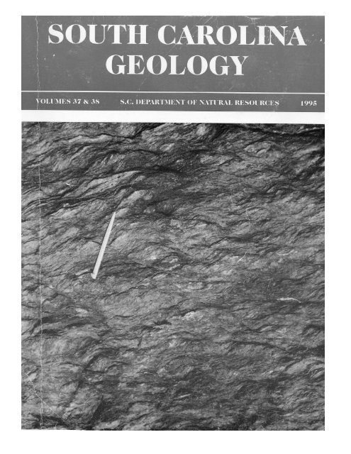
Cover photo; Well developed composite planar fabric in button schist of the ca. 275 Irmo shear zone indicates dextral<br />
shear. Normal slip crenulations consistently offset pre-existing, penetrative foliation surfaces to the right. 5 cm toothpick<br />
points approximately north on pavement surface. Outcrop is located off Forest Service Road 643A in Clarks Hill<br />
(SC-GA) 7.5’ quadrangle.
SOUTH CAROLINA GEOLOGY<br />
VOLUME 37 1995<br />
FIELD TRIP GUIDE FOR THE<br />
1995 CAROLINA GEOLOGICAL SOCIETY ANNUAL MEETING:<br />
GEOLOGY OF THE WESTERN PART OF THE CAROLINA TERRANE IN<br />
NORTHWESTERN SOUTH CAROLINA<br />
ALLEN J. DENNIS, J. ROBERT BUTLER, JOHN M. GARIHAN, WILLIAM A. RANSON, AND KEN-<br />
NETH A. SARGENT......................................................................................................................................1<br />
SOUTH CAROLINA GEOLOGY<br />
VOLUME 38 1995<br />
PAPERS RELATED TO THE THEME OF THE 1995 CAROLINA GEOLOGICAL SOCIETY ANNUAL MEETING:<br />
GEOLOGY OF THE WESTERN PART OF THE CAROLINA TERRANE<br />
ALLEN J. DENNIS, EDITOR<br />
Geologic contr<strong>as</strong>ts across the central Piedmont suture in north-central North <strong>Carolina</strong><br />
James K. Wilkins, Glenn S. Shell, and James P. Hibbard............................................................ ................... 25<br />
Gold deposits of the West Springs area, Union County, South <strong>Carolina</strong><br />
Dennis J. LaPoint......................................................................................................................................11<br />
Mississippian (Ca. 326-323 Ma) U-Pb crystallization ages for two granitoids in Spartanburg and Union<br />
Counties, South <strong>Carolina</strong><br />
Allen J. Dennis and James E. Wright........................................................................................................23<br />
Geology of M<strong>as</strong>ters’ Kiln and history of the marble occurrences in Laurens and Union Counties, South<br />
<strong>Carolina</strong><br />
John M. Garihan, William A. Ranson, Kenneth A. Sargent, and Clark A. Niewendorp..............................29
Mafic mineral crystallization in South <strong>Carolina</strong> Diab<strong>as</strong>e<br />
Richard D. Warner, Nichol<strong>as</strong> B. Kidd, David S. Snipes, and Jeffrey C. Steiner,,,,,,,,,,,,,,,,,,,,,,,,,,,,,,,,,,,,,,,,,37<br />
An initial petrographic and geochemical study of a rhyolitic rock recovered from Test Well #1, Hilton Head,<br />
South <strong>Carolina</strong><br />
D. S. Snipes, N.B. Kidd, R. D. Warner, R. A. Hodges, V. Price, Jr., and T. J. Temples...............................53<br />
Structural contr<strong>as</strong>ts of the <strong>Carolina</strong> slate belt and Charlotte belt in South <strong>Carolina</strong><br />
Terry W. Offield........................................................................................................................................61<br />
The Russell Lake Allochthon – A neglected tectonostratigraphic unit in the southern Appalachians<br />
Gilles Allard and James Whitney..............................................................................................................71<br />
Shallow seismic reflection profiling over an ultramafic complex in the <strong>Carolina</strong> terrane, NE Georgia<br />
Jeffrey E. Clippard and Roer B. Hawman................................................................................................79
CAROLINA GEOLOGICAL SOCIETY<br />
<strong>Guidebook</strong> for 1995 Annual Meeting<br />
Pages 1-21<br />
GEOLOGY OF THE WESTERN PART OF THE CAROLINA TERRANE IN NORTHWESTERN SOUTH<br />
CAROLINA: 1995 CAROLINA GEOLOGICAL SOCIETY FIELD TRIP<br />
ALLEN J. DENNIS 1<br />
Department of Biology and Geology, University of South <strong>Carolina</strong>-Aiken, Aiken, SC 29801-6309<br />
J. ROBERT BUTLER 2<br />
Department of Geology, University of North <strong>Carolina</strong>, Chapel Hill, NC 27599<br />
JOHN M. GARIHAN, WILLIAM A. RANSON, KENNETH A. SARGENT 3<br />
Department of Earth and Environmental Sciences, Furman University, Greenville, SC 29613<br />
1.Stops 1-2, 4-8, 10-12.<br />
2.Stops 3-4.<br />
3.Stop 9.<br />
SATURDAY ROAD LOG<br />
Begins at intersection of Main and Pine, downtown Spartanburg.<br />
Travel south and e<strong>as</strong>t on US 176. Go 7.7 (7.7) miles<br />
and turn left onto Quarry Road. Go 1.0 miles (8.7) and turn<br />
left into STOP 1 (Vulcan Materials Pacolet Quarry).<br />
Turn right out of quarry and go 1.0 (9.7) miles to US 176.<br />
Turn left onto US 176. Go 8.1 (17.8) miles and turn left onto<br />
Forest St. (S-44-12). At 0.8 (18.6) mile continue/bear right<br />
on Forest St. At 0.3 (18.9) mile, turn right on SC 9. At 1.1<br />
(20.0) miles continue straight on SC 9. At 7.6 (27.6) miles<br />
turn right onto Hyder Road. Continue down 0.5 (28.1) mile<br />
to end of road. Park and walk west about 100 m into old<br />
quarry STOP 2 (Hyder Bald Rock Quarry).<br />
Drive 0.4 (28.5) back out and turn right onto SC 9. Cross<br />
Broad River at 5.8 (34.3) miles. Turn right onto Chester<br />
byp<strong>as</strong>s at 14.0 (48.3) miles. At 3.7 (52.0) miles, turn right<br />
and rejoin SC 9. Turn left onto Meador St (S-12-74) at 3.6<br />
(55.6) miles, and at 0.1 (55.7) mile park left off into gr<strong>as</strong>sy<br />
field. Walk down to rail siding: STOP 3 (Chester metagabbro).<br />
Return to SC 9 0.1 (55.8) and turn right onto it. At 3.5 (59.3)<br />
miles turn left onto 72/121/9 byp<strong>as</strong>s. At 3.0 (62.3) miles turn<br />
left onto 72/121. At 1.4 (63.7) miles, Chester State Park. At<br />
9.4 (73.1) miles turn right (S-12-25) for Woods Ferry Recreation<br />
Area. At 5.6 (78.7) miles turn left onto road to Woods<br />
Ferry Rec. Area. At 0.2 (78.9) mile, Fire Tower, Leeds Hunt<br />
Camp on left. At 1.1 (80.0) miles turn left onto Forest Rd<br />
304. At 0.5 (80.5) miles bear right and continue 1.0 (81.5)<br />
mile to Neal Shoals, park. STOP 4 (Charlotte Belt intrusive<br />
complex).<br />
Return to S-12-25 (2.8/84.3) miles. Turn right onto S-12-25<br />
and after 5.6 (89.9) miles, turn right onto 121/72. At 5.1<br />
(95.0) miles, bear right on 215. At 8.7 (113.7) miles, bear left<br />
on 215. At 3.0 (116.7) miles, bear left, continue on 215. At<br />
3.1 (119.8) miles, turn left. At 3.4 (123.2) miles, bear right<br />
on S-44-23 Mudbridge Road. At 6.1 (129.3) miles, turn right<br />
on S-44-12. At 0.5 (129.8) mile, turn left onto Lanc<strong>as</strong>ter<br />
Road. Stop at Log House at 0.4 mile (130.2). Follow track<br />
behind house to STOP 5 (McClure Creek mafic metavolcanic<br />
rocks intruded by foliated biotite porphyry granodiorite).<br />
Return to S-44-12 (0.4/130.6 miles). Turn left and park 0.4<br />
(131.0) mile at gate on left for McClure Creek Hunt Club.<br />
Walk down track and turn right at second deer stand and follow<br />
hill down to creek: STOP 6 (Undeformed, unmetamorphosed<br />
diorite containing foliated xenoliths and equant<br />
mafic enclaves).<br />
Continue straight on S-44-12 and turn right onto S-44-12 at<br />
0.7 (131.7) miles, crossing Fairforest Creek. At 0.2 (131.9)<br />
mile park at McClure Creek Hunt Club gate: STOP 7 (Mean<br />
Crossroads metadiorite-diorite gneiss).<br />
Turn around and follow S-44-12, turning left after crossing<br />
Fairforest Creek and continuing to follow S-44-12, p<strong>as</strong>t Lanc<strong>as</strong>ter<br />
and Mudbridge Roads, to its intersection with 215<br />
(3.8/135.7 miles). Turn left on 215 and continue for 2.8<br />
(138.5) miles to S-44-25. At 1.1 (139.6) miles, turn left on S-<br />
44-33; at 1.9 (141.5) miles turn right onto S-44-210. At 0.7<br />
(142.2) miles, begins abundant gabbro outcrop, and at 0.3<br />
(142.5) miles felsic intrusive rocks. STOP 8: Buffalo gabbro<br />
and <strong>as</strong>sociated felsic rocks.<br />
Return to intersection with 215 (4.0/146.5), and turn left.<br />
Follow 215 to 56 at Pauline, and continue on 56 to Spartanburg,<br />
Routes 9 and 176.<br />
END OF SATURDAY ROAD LOG.<br />
SUNDAY ROAD LOG.<br />
Sunday Road Log begins Exit 44 (SC 49) on I-26 south of<br />
Spartanburg.<br />
Follow SC 49 south and west to Laurens (6.4 miles to I-385<br />
intersection). At 2.6 (9.0) miles turn left onto US 221. At 1.5<br />
(10.5) miles turn right onto US 76.<br />
The following three sentences trace the 76 byp<strong>as</strong>s around<br />
Laurens to where SC 252 separates from US 76 west of Laurens.<br />
Bear right at 0.8 (11.3) mile, and turn left at 0.2 (11.5).<br />
1
Allen J. Dennis and Others<br />
Turn right at 1.2 (12.7) miles, and left onto SC 252 at 1.4<br />
(14.1) miles. At 9.4 (23.5) miles, turn left onto Poplar<br />
Springs Road (S-30-64). At 1.2 (24.7) miles turn left onto<br />
Gilbert Road. Continue 0.95 (25.7) miles to the end of the<br />
gravel road. Park in the yard of the log home of Gerald and<br />
Diane Mitchell, and walk downhill about 300 m south of the<br />
house. STOP 9: M<strong>as</strong>ters Kiln and marbles.<br />
Retrace route back to SC 49 - I-26 intersection (25.7/51.4<br />
miles). Continue on SC 49 3.1 (54.5) miles to Cross Anchor.<br />
Turn right at Cross Anchor onto SC 56. At 1.8 (56.3) miles<br />
bear right onto Horseshoe Falls Road. At 1.4 (57.7) miles<br />
cross bridge over Cedar Shoals Creek and 0.3 (58.0) miles<br />
park for STOP 10: Inner Piedmont gneisses at Cedar Shoals.<br />
Retrace route to SC 56 and continue north (1.7/59.7 miles).<br />
At 5.0 (64.7) miles turn right onto Blackstock Road (S-42-<br />
115, Woodsmen Sportsmen Club sign). At 0.8 (65.5) mile,<br />
just p<strong>as</strong>t bridge over Hackers Creek, pull off at gate on left<br />
hand side of road, and hike about 300 m northe<strong>as</strong>t to STOP<br />
11: Hackers Creek folded mylonite.<br />
Return to SC 56 and turn right (0.8/66.3 miles). At 1.7 (68.0)<br />
miles fork right onto S-42-511 (Shealton Road), and right<br />
onto Toal Road at 0.3 (68.3) miles. Park either at bridge (0.5/<br />
68.5 miles) or at gate near Westvaco property line (0.3 mile<br />
p<strong>as</strong>t bridge/68.8). Stay on Westvaco property and proceed<br />
south to STOP 12: metavolcanic rock outcrops on Dutchman<br />
Creek.<br />
Return to SC 56 (not bearing left onto Shealton Road, but<br />
continuing straight on Toal), and turn right, proceeding north<br />
to Spartanburg and SC 9.<br />
END OF TRIP<br />
STOP 1: VULCAN MATERIALS PACOLET<br />
GRANITE QUARRY<br />
LOCATION<br />
The quarry is located off US 176, west of Pacolet, South<br />
<strong>Carolina</strong>. (Fig. 1, Pacolet quadrangle)<br />
DESCRIPTION<br />
The Pacolet granite ranges from porphyritic to equigranular<br />
in texture. The Vulcan Materials quarry offers examples<br />
of both (pot<strong>as</strong>sium feldspar) porphyritic and equigranular<br />
ph<strong>as</strong>es of the granite. This quarry shows very clearly diking<br />
and discrete faulting in the granite that would be obscure in<br />
small Piedmont bedrock exposures. The dikes comprise both<br />
fine-grained leucogranite or al<strong>as</strong>kite and quartz-pot<strong>as</strong>sium<br />
feldspar-biotite pegmatites. Mutual cross-cutting relations<br />
between both types of dikes suggests that both types of dikes<br />
are related to the intrusion of the Pacolet granite and that the<br />
pegmatites are not a distinct different event. The significance<br />
of this observation will be discussed below. An approximately<br />
e<strong>as</strong>t-west striking fault zone dipping about 50° south,<br />
and e<strong>as</strong>t-west striking vein arrays may be observed at the<br />
south end of the active workings (Fig. 2). These vein arrays<br />
seem to have a consistent geometry: veins dipping about 50°<br />
north are several times thicker (ca. 1 m) than those that dip<br />
about 20° south (10's of cm thick). The kinematic significance<br />
of this geometry is not clear. It probably does not have<br />
its origin in rotated tension g<strong>as</strong>hes (Hudleston, 1989), which<br />
would indicate top-to-the-north, because there appear to be<br />
only two dominant orientations, rather than a continuous<br />
range of orientations. The simplest explanation may be that<br />
these vein arrays represent a conjugate set related to the<br />
stresses at the time of emplacement of the Pacolet granite.<br />
David Cosh the quarry foreman suggested that the frequency<br />
of veining or diking may incre<strong>as</strong>e with depth.<br />
Mittwede and Fullagar (1987) reported an whole rock<br />
Rb-Sr isochron for the Pacolet granite of 383±5 Ma b<strong>as</strong>ed on<br />
8 points, a biotite mineral age of 292 Ma, and a initial 87 Sr/<br />
86 Sr ratio of 0.7046±2. No more than 1.5 km to the west of<br />
the quarry, and 100's of m from the western edge of the pluton,<br />
the central Piedmont suture separating Inner Piedmont<br />
from the <strong>Carolina</strong> terrane rocks is exposed. Quartz-pot<strong>as</strong>sium<br />
feldspar-muscovite (rather than biotite) pegmatites are<br />
typically observed near the trace of the central Piedmont<br />
suture in the three quadrangles south of here (Glenn Springs,<br />
Cross Anchor, Philson Crossroads; Dennis, 1991). Only on<br />
the northern margin of the pluton are rocks of the Pacolet<br />
granite interpreted by Mittwede (1989) to be sheared; this<br />
fabric is thought to be an extension of Alleghanian strike-slip<br />
motion on the Kings Mountain shear zone (Horton, 1981).<br />
Foliation attitudes in rocks adjacent to the pluton parallel the<br />
pluton margin, and typically dip 50-70° to the southe<strong>as</strong>t.<br />
Dennis (1991, 1995) presents form surface maps that show<br />
that the regional metamorphic fabric predates the central<br />
Piedmont suture and that this fault crosscuts the foliation.<br />
The purpose of this discussion and this stop is to bring<br />
together data that bear on the relative timing of motion on<br />
the central Piedmont suture versus the date of the intrusion<br />
of Pacolet granite. Did the Pacolet granite predate or postdate<br />
motion on the central Piedmont suture? If the central<br />
Piedmont suture dips at ca. 25°, the projected depth to contact<br />
with where the central Piedmont suture would be about<br />
700 m beneath the quarry floor. Is the pluton decapitated or<br />
does the pluton postdate this fault? Dennis (1995) and Dennis<br />
and Shervais (1992) argue that the sequence of events<br />
w<strong>as</strong> metamorphic fabric development in <strong>Carolina</strong> terrane<br />
rocks (ca. 570-538 Ma, Dennis and Wright, 1993), ductile<br />
motion on central Piedmont suture, intrusion of post-metamorphic<br />
granites and gabbros (ca. 383±5 Ma, e.g. Mittwede<br />
and Fullagar), west-vergent folding of foliation surfaces and<br />
retrograde strike-slip shearing on northe<strong>as</strong>t-striking segments<br />
of the central Piedmont suture (Alleghanian, 300-280<br />
Ma).<br />
Most of the Pacolet granite outcrops in the Pacolet and<br />
Pacolet Mills quadrangles, however, to the south in the<br />
northern part of the Glenn Springs quad, a megacrystic por-<br />
2
GEOLOGY OF THE WESTERN PART OF THE CAROLINA TERRANE IN NORTHWESTERN SOUTH CAROLINA<br />
Fig 2. a. View e<strong>as</strong>t at south end of Pacolet quarry showing fault dipping 50-60° south, steeply north dipping veins, and shallowly<br />
south dipping, thinner veins. b. View e<strong>as</strong>t at the north end of the quarry. Veins dipping 45° north are ca. 1 m thick. Veins dipping<br />
20° south are 10's of cm thick. Exposed face is slightly less than 100 m high.<br />
3
Allen J. Dennis and Others<br />
Fig 4. View into the Hyder Bald Rock quarry.<br />
4
GEOLOGY OF THE WESTERN PART OF THE CAROLINA TERRANE IN NORTHWESTERN SOUTH CAROLINA<br />
phyry w<strong>as</strong> mapped by Dennis (1989) in erosional windows<br />
through the aluminous schists of the Battleground Formation.<br />
That megacrystic porphyry is interpreted to be a ph<strong>as</strong>e<br />
of the Pacolet granite and not a tectonic window through the<br />
<strong>Carolina</strong> terrane into the Inner Piedmont (Dennis, 1989). The<br />
contact is interpreted to be intrusive; fault rocks are not recognized.<br />
STOP 2: HYDER FARM BALD ROCK GRANITE<br />
QUARRY<br />
LOCATION<br />
The “quarry” is located in a p<strong>as</strong>ture approximately 300<br />
m southwest of the house at the end of Hyder Road, off SC<br />
Highway 9. Hyder Road is 0.8 mile west of the intersection<br />
of SC 9 with S-42-57. (Fig. 3, Kelton quadrangle)<br />
DESCRIPTION<br />
This abandoned quarry (Fig. 4) illustrates the salient<br />
features of the Bald Rock granite: its megacrystic texture,<br />
the strong alignment of phenocrysts, and the parallel alignment<br />
of mafic enclaves. The megacrystic granite here is<br />
coarse-grained. The most common mafic ph<strong>as</strong>e here is<br />
biotite, hornblende may also be found. The orientation of<br />
megacrysts and mafic enclaves here is about north-south.<br />
Wagener (1977) reports that this quarry provided crushed<br />
stone for the interstate highway system.<br />
Dennis and Wright (1993, 1995) have dated the Bald<br />
Rock granite by the U-Pb zircon method. Three fractions of<br />
zircon yielded an upper intercept at 323±3 Ma interpreted to<br />
be a crystallization age. Their sample came from this location.<br />
Dallmeyer and others (1986, p. 1331) report an 1985<br />
personal communication from P.D. Fullagar that the Rb-Sr<br />
age of biotite from the Bald Rock pluton is ca. 290 Ma (cf.<br />
292 Ma biotite age of Pacolet granite). Speer and others<br />
(1986) reported mineral chemistry for biotite, amphibole and<br />
pyroxene from the Bald Rock granite, and compared their<br />
results to mineral chemistry of known Carboniferous plutons<br />
of the e<strong>as</strong>tern Piedmont. Vhynal and McSween (1990) used<br />
the Al-in-hornblende (7 grains) barometer to estimate a crystallization<br />
pressure for the Bald Rock at 4.8±0.5 kbar or<br />
18.5±2km. Vhynal and McSween (1990) prepared pressure<br />
estimates for 14 Carboniferous plutons from both the e<strong>as</strong>tern<br />
Piedmont (<strong>Carolina</strong> slate belt: 10.8-11.6 km depth of<br />
emplacement) and central Piedmont (14.2-19.3 km depth of<br />
emplacement) and documented the Alleghanian-regional<br />
scale warping of isotherms suggested by regional reconnaissance<br />
40 Ar/ 39 Ar ages and other mineral ages and proposed<br />
by Dallmeyer and others (1986) and Secor and others<br />
(1986).<br />
Speer and others (1986) and van Gelder and McSween<br />
(1981) present maps of the megacryst and mafic enclave fabric<br />
of the Bald Rock pluton. Generally the magmatic foliation<br />
is broadly concentric with the pluton margins, but<br />
tapered mafic enclaves define an <strong>as</strong>ymmetric, counterclockwise<br />
pattern that Speer and others (1986) suggested w<strong>as</strong> a<br />
consequence of either irregularities in the magma chamber<br />
or emplacement in a left-lateral fault zone. B<strong>as</strong>ed on contr<strong>as</strong>ts<br />
in metamorphic grade and structural style e<strong>as</strong>t and<br />
west of the pluton (that will be observed later on this trip), it<br />
appears that the Bald Rock did intrude an existing fault zone,<br />
however, it h<strong>as</strong> been difficult to evaluate the hypothesis of<br />
left-lateral shear along this zone in early Alleghanian time.<br />
This is not the first <strong>Carolina</strong> <strong>Geological</strong> <strong>Society</strong> field<br />
trip to visit this site. In 1973 the 34th annual meeting b<strong>as</strong>ed<br />
in Pageland and led by H.D. Wagener and D.E. Howell led a<br />
trip titled “Granitic Plutons of the central and e<strong>as</strong>tern Piedmont<br />
of South <strong>Carolina</strong>.” This w<strong>as</strong> their stop 10.<br />
The Bald Rock granite h<strong>as</strong> a historical tie. The Union<br />
Jail on West Main Street w<strong>as</strong> designed and construction<br />
supervised by South <strong>Carolina</strong> architect Robert Mills (1781-<br />
1855) over the period 1822-1823. The original design called<br />
for brick construction, however after a problem with the<br />
quality of the brick w<strong>as</strong> recognized, Mills ordered the brick<br />
torn down, and after learning of the existence of a nearby<br />
granite quarry (Humphries quarry west of town, <strong>as</strong> described<br />
by Sloan, 1908 and Wagener, 1977), elected to complete the<br />
outside walls with Bald Rock granite. Among Mills’ many<br />
later accomplishments were the US Tre<strong>as</strong>ury Building<br />
(1836, completed in 1842), Old Patent Office (now part of<br />
the Smithsonian Institution), and the W<strong>as</strong>hington Monument<br />
(1836, completed 1884). The Union Jail is still in use and is<br />
the oldest functioning jail in the state and the oldest intact<br />
public building in the county (Charles, 1987).<br />
STOP 3: CHARLOTTE BELT METAGABBRO<br />
AND GABBRO, ALONG RAILROAD SPUR JUST<br />
NORTH OF SC HIGHWAY 9 IN EASTERN<br />
CHESTER COUNTY, SOUTH CAROLINA.<br />
LOCATION<br />
The outcrops are along a railroad spur to the PPG Chester<br />
Plant, just north of SC-9 and just west of S-12-74, e<strong>as</strong>t of<br />
Chester. Park along S-12-74 and walk west to the railroad<br />
cuts. (Fig. 5, Chester Quadrangle)<br />
Description<br />
The rocks exposed in the banks exposed of the railroad<br />
cut are mainly dark-colored, medium grained metagabbro<br />
that is the most extensive rock type in the York-Chester<br />
mafic complex. Nearly everywhere the metagabbro is deeply<br />
weathered and forms low, flat, thickly vegetated topography.<br />
This is the best accessible exposure found in the region so<br />
far. The metagabbro is generally m<strong>as</strong>sive, but locally it is<br />
strongly deformed and h<strong>as</strong> a tectonic foliation. There are<br />
shear zones of chlorite-rich schist, retrograded from the metagabbro.<br />
The metagabbro h<strong>as</strong> some inclusions of mafic and<br />
possibly ultramafic rocks, and it is cut by several mafic dikes<br />
5
Allen J. Dennis and Others<br />
and a number of pegmatite and granite dikes. In thin sections<br />
the m<strong>as</strong>sive rocks have relict igneous hypautomorphic-granular<br />
texture, strongly modified by replacement of original<br />
minerals by fine-grained, greenschist facies minerals such <strong>as</strong><br />
actinolite, chlorite, epidote and albite. The texture, chemical<br />
composition, and relict crystals of hornblende, pyroxene,<br />
and calcic plagiocl<strong>as</strong>e indicate that the rocks w<strong>as</strong> originally<br />
hornblende gabbro or gabbro-norite. Regional metamorphism<br />
here w<strong>as</strong> under greenschist facies conditions, in contr<strong>as</strong>t<br />
with regional amphibolite facies conditions in most of<br />
the Charlotte belt.<br />
Near the southern end of the railroad cuts and about 80<br />
meters north of SC-9, there are several low exposures of<br />
residual boulders of unmetamorphosed olivine gabbro. The<br />
gabbro is very different from rocks farther north in the outcrop,<br />
although there are no clear differences in soil and<br />
saprolite in between that would define a contact. The gabbro<br />
is similar to rocks that make up the Chester gabbro pluton,<br />
about 1.4 km to the west along SC-9. The gabbro is mediumgrained<br />
and composed of plagiocl<strong>as</strong>e, olivine, augite, hypersthene,<br />
hornblende, and opaque minerals, with small<br />
amounts of biotite and spinel. This occurrence of gabbro is<br />
interpreted to be a dike or a small plug related to the Chester<br />
pluton, but it could be part of a larger body underlying the<br />
covered area south of the outcrop. These outcrops illustrate<br />
the difficulties of mapping gabbro versus metagabbro.<br />
STOP 4: CHARLOTTE BELT INTRUSIVE COM-<br />
PLEX AT NEAL SHOALS DAM, ON THE<br />
BROAD RIVER IN WESTERN CHESTER<br />
COUNTY (FIG. 6, LEEDS QUADRANGLE)<br />
LOCATION<br />
The outcrops are just below the e<strong>as</strong>tern abutment of<br />
Neal Shoals Dam on the Broad River, at the end of National<br />
Forest Road 304, Sumter National Forest. The Neal Shoals<br />
Dam is owned by South <strong>Carolina</strong> Electric and G<strong>as</strong> Company.<br />
DESCRIPTION<br />
Below the dam, there are excellent outcrops of fresh<br />
rock and saprock swept clean by periodic overflow. The<br />
main outcrop area is about 100m long by about 60 m wide.<br />
The rocks range in composition from felsic to mafic. The<br />
oldest rocks are inclusions of hornblende gneiss, amphibolite<br />
6
GEOLOGY OF THE WESTERN PART OF THE CAROLINA TERRANE IN NORTHWESTERN SOUTH CAROLINA<br />
Fig. 7. View northwest across Stop 4, Neal Shoals<br />
and metagabbro in granite and diorite. Various granitoid<br />
rocks make up the majority of the exposure. At le<strong>as</strong>t two<br />
types of mafic dikes and numerous pegmatite dikes crosscut<br />
the older units. Some rocks have a well developed tectonic<br />
foliation, but others are essentially undeformed. Where foliation<br />
and layering are developed they typically strike northnorthe<strong>as</strong>t<br />
and dip steeply e<strong>as</strong>t-southe<strong>as</strong>t, approximately parallel<br />
to the regional trend. The outcrops here show many features<br />
typical of the Charlotte belt intrusive complexes in this<br />
region, but elsewhere they are mostly exposed piecemeal in<br />
small saprolitic outcrops. Here they are well displayed in one<br />
small area.<br />
For convenience in pointing out the features, the exposure<br />
is divided into three parts, northern, central and southern,<br />
but they are all interpreted to be <strong>as</strong>pects of a single<br />
intrusive complex. The northern part (Fig. 7) is mostly foliated<br />
biotite granite with numerous inclusions of mafic rocks,<br />
all of which are cut by pegmatite dikes. The mafic inclusions<br />
are mostly amphibolite and hornblende gneiss that are typically<br />
elongate and oriented parallel to the regional trend.<br />
Some inclusions have wispy and stringy ends, suggesting<br />
partial <strong>as</strong>similation and mixing with the granite magma.<br />
The central part (Fig. 7) of the outcrop is mostly a variety<br />
of mafic rocks with some granite, cut by a mafic dike and<br />
numerous pegmatite dikes. The largest mafic body is a finegrained<br />
biotite amphibolite with porphyrobl<strong>as</strong>ts of hornblende<br />
and relict (?) phenocrysts of plagiocl<strong>as</strong>e. The mafic<br />
dike is about one meter thick and h<strong>as</strong> strong ductile deformation<br />
along its contacts. Rotation of the foliation and layering<br />
in the adjacent granite and amphibolite indicate that the<br />
block north of the dike moved relatively e<strong>as</strong>tward. The dike<br />
is a metagabbro, with mineral <strong>as</strong>semblages indicative of<br />
amphibolite facies metamorphism.<br />
The southern part of the outcrop is mainly strongly foliated<br />
coarse-grained granite, with some mafic inclusions, that<br />
is cut by a fine-grained, foliated mafic dike and many pegmatite<br />
dikes. In the steep bank on the e<strong>as</strong>tern side of the outcrop,<br />
colluvium <strong>as</strong> much a two meters thick unconformably<br />
overlies saprolite of the intrusive complex.<br />
The rocks here are interpreted to have been emplaced<br />
during a single protracted sequence of magmatic events. The<br />
7
Allen J. Dennis and Others<br />
Fig. 8. Geologic map of a portion of the Glenn Springs and Jonesville quadrangles, showing the location of Stops 5, 6, 7. Light<br />
grey - mafic metavolcanic rocks; outlined are<strong>as</strong> within light grey - quartz sericite schist or silicification; no pattern - felsic<br />
metavolcanic rocks; dark grey - metapyroxenite-hornblendite; double bar random pattern - metagabbro; rippled gneiss pattern -<br />
Mean Crossroads metadiorite-diorite gneiss; random dot pattern - foliated biotite porphyry granodiorite; aligned crosses - undeformed,<br />
unmetamorphosed diorite; single bar random pattern - Bald Rock granite. Adapted from Dennis and Wright (1996).<br />
8
GEOLOGY OF THE WESTERN PART OF THE CAROLINA TERRANE IN NORTHWESTERN SOUTH CAROLINA<br />
mineral <strong>as</strong>semblages indicate perv<strong>as</strong>ive metamorphism<br />
under amphibolite facies conditions. There is considerable<br />
evidence for ductile deformation. The l<strong>as</strong>t major event,<br />
emplacement of the swarm of pegmatites must have taken<br />
place while temperatures were still high. At this outcrop, we<br />
are probably looking at the midcrustal underpinnings of the<br />
Charlotte belt magmatic arc.<br />
The next three field trip stops are very close together<br />
(Fig. 8), and illustrate the coeval magmatism, deformation,<br />
and metamorphism that distinguished the <strong>Carolina</strong> terrane in<br />
the latest Precambrian through early Cambrian (Dennis and<br />
Wright, 1993, 1996). All the events recorded here occurred<br />
on the fringes of Gondwana. Dennis and Shervais (1995) and<br />
Dennis (1995) discuss these events in the context of a tectonic<br />
model presented by Nance and Murphy (1994).<br />
STOP 5: MAFIC METAVOLCANIC ROCKS OF<br />
CAROLINA TERRANE INTRUDED BY FOLI-<br />
ATED BIOTITE PORPHYRY GRANODIORITE,<br />
MCCLURE CREEK<br />
LOCATION<br />
The outcrops are located on McClure Creek approximately<br />
200 m northwest of (behind) log home on Lanc<strong>as</strong>ter<br />
Road. Lanc<strong>as</strong>ter Road is off S-42-12, 0.5 mile north of the<br />
intersection of S-42-12 with S-42-23. (Fig. 9, Glenn Springs<br />
quadrangle)<br />
DESCRIPTION<br />
Here are observed mafic to intermediate metavolcanic<br />
rocks that are intruded by a biotite porphyry granodiorite.<br />
Volcanic rocks show porphyritic and amygdaloidal textures,<br />
and appear highly strained (Fig. 10). The contact with the<br />
granodiorite is gently dipping and near the water level in<br />
McClure Creek. The granodiorite is characterized by biotite<br />
clots that define a crude lineation and have dimensions<br />
approximately 2 cm x 1 cm x 2 mm. The granodiorite h<strong>as</strong> a<br />
strong, almost gneissic fabric that parallels that in the mafic<br />
metavolcanic rock. Petrographic examination indicates that<br />
this is a composite planar fabric (so-called “S-C”) and that<br />
the granodiorite (and its country rock) have been ductilely<br />
sheared (Fig. 11). It is suggested here that the granodiorite is<br />
intruded into a locally significant dextral shear zone (of late<br />
Precambrian-early Cambrian age) b<strong>as</strong>ed on the <strong>as</strong>ymmetric<br />
tear-drop shape of the pluton and the sudden “hard-right”<br />
turn (at the map scale) of the foliation <strong>as</strong> it enters the pluton.<br />
Foliations strike northerly to north and slightly west.<br />
Dips are steep (>70°) and to the west. This is typical for<br />
rocks of the <strong>Carolina</strong> terrane in this area. The thin foliation<br />
9
Allen J. Dennis and Others<br />
Fig. 10. Amygdaloidal greenstone on McClure Creek,<br />
Stop 5. Note subvertical foliation.<br />
Fig. 11. Photomicrograph of foliated biotite porphyry granodiorite,<br />
Stop 5. Note rounded plagiocl<strong>as</strong>e porphyrycl<strong>as</strong>t wrapped in biotite.<br />
Aggregates of biotite flakes elsewhere in this pluton define a composite<br />
planar fabric that is subvertical in orientation. Field of view<br />
approximately 25 mm.<br />
or cleavage observed mesoscopically on weathered rock surfaces<br />
is also typical. In thin section or on some fresh surfaces<br />
in hand specimen, it may be seen that the mafic metavolcanic<br />
rocks have been completely recrystallized with the<br />
growth of relatively coarse, idiobl<strong>as</strong>tic amphiboles, and finegrained,<br />
equant, polygonal grains making up the felsic<br />
ph<strong>as</strong>es. The origin of this recrystallization is obscure.<br />
Dennis and Shervais (1995) present geochemistry for an<br />
amphibolite at this site (their “McClure Porphyry”) that is an<br />
andesite. Dennis and Shervais (1995) report an ankaramite<br />
Fig. 12. Foliated xenolith in undeformed, unmetamorphosed diorite,<br />
Stop 6. Foliation orientation is at a high angle to the contact,<br />
and is consistent with orientations of foliation outside the pluton.<br />
Fig. 13. Equant mafic enclave within undeformed,<br />
unmetamorphosed diorite, Stop 6.<br />
10
GEOLOGY OF THE WESTERN PART OF THE CAROLINA TERRANE IN NORTHWESTERN SOUTH CAROLINA<br />
Fig. 14. Photomicrograph of undeformed, unmetamorphosed diorite, showing good igneous texture and mineralogy, Stop 6. Field of<br />
view approximately 25 mm<br />
tuff (their 1512) upstream (south) of this site on McClure<br />
Creek. The area south of this stop to West Springs is a historic<br />
locus of gold exploration in this part of South <strong>Carolina</strong><br />
<strong>as</strong> discussed by LaPoint (1995) in this volume. In this area it<br />
is not unusual to find mafic and ultramafic dikes cross-cutting<br />
the quartz-sericite alteration zones that are frequently an<br />
gold exploration target. This indicates that the alteration w<strong>as</strong><br />
broadly coeval with ongoing mafic and ultramafic volcanism<br />
accompanying arc-rifting <strong>as</strong> described by Dennis and Shervais<br />
(1991).<br />
Dennis and Wright (1993, 1996) analyzed two fractions<br />
of zircon by the U-Pb method from the foliated biotite porphyry<br />
granodiorite at this stop. They interpret the upper<br />
intercept at 571±16 Ma <strong>as</strong> a crystallization age. To the south<br />
of this area in the Cross Anchor quad, Dennis and Wright<br />
(1993, 1996) dated another foliated diorite that also intrudes<br />
mafic metavolcanic rocks (at Stop 12). Four size fractions of<br />
zircon including an air-abraded fraction dated by U-Pb yield<br />
an upper intercept interpreted <strong>as</strong> a crystallization age at<br />
579±4 Ma. Thus at le<strong>as</strong>t in these two are<strong>as</strong>, mafic metavolcanic<br />
rocks predate ca. 570-580 Ma, and the observed metamorphic<br />
fabric postdates ca. 570 Ma.<br />
STOP 6: UNDEFORMED, UNMETAMOR-<br />
PHOSED DIORITE<br />
Fig. 15. Photomicrograph of gneissic metadiorite of Mean<br />
Crossroads complex, Stop 7. Whether samples contain a<br />
good metamorphic fabric or not, all samples show the ubiquitous<br />
development of epidote at the expense of plagiocl<strong>as</strong>e.<br />
The contact between this pluton and mafic metavolcanic<br />
rocks observed at Stop 5 is cut by the undeformed, unmetamorphosed<br />
pluton observed at Stop 6.<br />
LOCATION<br />
The outcrops are located on the unnamed tributary to<br />
Fairforest Creek south of McClure Creek. Park at the gate on<br />
S-42-12 located 0.4 miles north of the intersection of Lanc<strong>as</strong>ter<br />
Road and S-42-12. Walk e<strong>as</strong>t along the track and turn<br />
right (south, downhill) at the second deerstand down to the<br />
creek. (Fig. 9, Jonesville quad)<br />
DESCRIPTION<br />
In a traverse of several hundred meters along this tributary,<br />
it is possible to see mafic metavolcanic rocks intruded<br />
by an undeformed, unmetamorphosed diorite. In fact the<br />
diorite intrudes the contact between mafic metavolcanic<br />
rocks and diorite gneiss (Stop 7). The diorite contains foliated<br />
xenoliths of mafic metavolcanic rocks (Fig. 12) and<br />
mappable blocks of metagabbro and diorite gneiss (Fig. 8) of<br />
the Mean Crossroads complex. The orientation of the metamorphic<br />
fabric in these xenoliths and blocks is consistent<br />
with the orientation in the country rock and at a high angle to<br />
the intrusive contact. The diorite gneiss at this location also<br />
contains equant (spherical?) mafic enclaves (Fig. 13). Petro-<br />
11
Allen J. Dennis and Others<br />
graphic examination of the undeformed diorite shows igneous<br />
textures and mineralogy is preserved (Fig. 14). Every<br />
indication is that this rock is a post-metamorphic pluton.<br />
Dennis and Wright (1993, 1996) dated three size fractions<br />
of zircon from the diorite at this site by the U-Pb<br />
method and interpreted the resulting upper intercept at<br />
535±4 Ma <strong>as</strong> a crystallization age. Comparing this age with<br />
that reported by Dennis and Wright (1993, 1996) for Mean<br />
Crossroads metadiorite-diorite gneiss, one concludes that the<br />
metamorphic fabric observed in these rocks of the Charlotte<br />
belt must be older than 535±4 Ma. The Acado-Baltic fossils<br />
from the <strong>Carolina</strong> slate belt reported by Samson and others<br />
(1990) are middle Cambrian in age. Thus, we conclude that<br />
the metamorphic fabric observed here did not form <strong>as</strong> a consequence<br />
of collision of the <strong>Carolina</strong> arc with Laurentia, but<br />
must record events on the fringes of Gondwana (Dennis and<br />
Wright, 1995). Jim Hibbard and Scott Samson (1995) have<br />
correlated this deformation with the Virgilina orogeny of<br />
Glover and Sinha (1973).<br />
STOP 7: MEAN CROSSROADS METADIORITE/<br />
DIORITE GNEISS<br />
LOCATION<br />
: The outcrops are located on dirt tracks leading north<br />
and west around the prominent hill located 0.2 mile west of<br />
the S-42-12 bridge over Fairforest Creek. (Fig. 9, Jonesville<br />
quadrangle)<br />
DESCRIPTION<br />
Loose boulders and cobbles of metadiorite and diorite<br />
gneiss of the Mean Crossroads complex (Dennis and Shervais,<br />
1991) litter the slopes of this prominent hill. Some samples<br />
show little fabric at all with randomly oriented coarse<br />
hornblende needles, others have a mylonitic foliation. What<br />
is common to all samples is the ubiquitous development of<br />
epidote at the expense of plagiocl<strong>as</strong>e (Fig. 15). This is interpreted<br />
to indicate intrusion of the Mean Crossroads diorite<br />
relatively late in the late Precambrian-early Cambrian orogenic<br />
event, when rather than a zone of broad, distributed<br />
strain, deformation w<strong>as</strong> restricted to narrow bands irregularly<br />
distributed through a pluton that w<strong>as</strong> intruded into a<br />
semicontinuously deforming zone.<br />
Dennis and Wright (1993, 1996) dated four size fractions<br />
of zircon from this site by the U-Pb method. The data<br />
plot in a highly linear array with an upper intercept at 538±5<br />
Ma, interpreted to be the crystallization age of the diorite and<br />
the age of the Mean Crossroads complex.<br />
The Mean Crossroads complex w<strong>as</strong> identified by Dennis<br />
(1988) and described by Dennis and Shervais (1991,<br />
1995). The Mean Crossroads complex is zoned intrusive<br />
complex that h<strong>as</strong> a hornblendite-clinopyroxenite core, surrounded<br />
by varieties of gabbro, and mantled by a thick rind<br />
of diorite. This entire package w<strong>as</strong> metamorphosed at greenschist<br />
to lower amphibolite facies. It is believed that at le<strong>as</strong>t<br />
some of the mafic metavolcanic rocks in this area were<br />
derived from the Mean Crossroads complex because<br />
ankaramite and ultramafic dikes crosscut the plutonic rocks.<br />
Dennis (1988) and Dennis and Shervais (1991, 1992, 1995)<br />
argue that the Mean Crossroads complex, Wildcat Branch<br />
complex, the Hammett Grove Meta-Igneous Suite, York-<br />
Chester mafic-ultramafic complex, Davie County Complex<br />
(NC), Latimer (SC)-Nancy Hart (GA) complex, and Berner<br />
mafic complex represent loci of arc-rifting along the western<br />
edge of the <strong>Carolina</strong> arc while the arc w<strong>as</strong> in a periGondwanide<br />
position. Probably the C<strong>as</strong>well County complex<br />
described by Wilkins and others (1995) also belongs in this<br />
group. This arc-rifting occurred in the western <strong>Carolina</strong> terrane<br />
at the same time or slightly younger than eruption of<br />
Persimmon Fork Formation, Lincolnton metadacite, Uwharrie<br />
Formation, ca. 550 Ma (Dennis, 1995; Dennis and Shervais,<br />
1995).<br />
STOP 8: BUFFALO GABBRO/SYENITE CON-<br />
TACT<br />
LOCATION<br />
The outcrops are located on S-42-210, 0.7 mile south of<br />
the intersection with S-42-33. (Fig. 16, Cross Anchor quadrangle)<br />
DESCRIPTION<br />
These road cuts and boulders in the adjacent woods<br />
show the Buffalo gabbro and the <strong>as</strong>sociated felsic rocks<br />
mapped on its south margin, and the contact between these<br />
two rock types (Medlin, 1966; Medlin and others, 1972).<br />
The gabbro here is medium to coarse-grained and black in<br />
color. In fact, the mafic rocks of the Buffalo gabbro grade in<br />
no apparently systematic way from gabbro to norite (Medlin<br />
and others, 1972). Medlin and others (1972) report modal<br />
percentages of olivine from 0-20.9% (norites) and 0-23%<br />
(gabbros); orthopyroxene from 12-42.2% (norites) and 0.6-<br />
21.9% (gabbros); and clinopyroxene from 7.2-36.3%<br />
(norites) and 7.8-58% (gabbros). Medlin and others (1972)<br />
report 8 olivine, 3 orthopyroxene, and 6 clinopyroxene mineral<br />
analyses: olivines range from Fo68-Fo80.6; orthopyroxenes<br />
from En75-En78; and, clinopyroxenes from<br />
Wo41.5-En44.5 to Wo44En41.<br />
The felsic rocks are bluish-grey with bluish pot<strong>as</strong>sium<br />
feldspar phenocrysts. Medlin (1966) terms these rocks<br />
“biotite quartz monzonite,” and Willis (1984) calls them<br />
“syenodiorite.” Two modal analyses (Medlin and others,<br />
1972) plotted on the 1976 IUGS cl<strong>as</strong>sification scheme<br />
(Streckeisen, 1976) yield points in the quartz monzonite<br />
(QAP -> 14-43-43) and quartz syenite (9-62-29) fields Medlin<br />
and others (1972) did not think that there w<strong>as</strong> a necessarily<br />
a petrogenetic or magmatic relation between the felsic<br />
and mafic rocks, but without explicitly establishing the rela-<br />
12
GEOLOGY OF THE WESTERN PART OF THE CAROLINA TERRANE IN NORTHWESTERN SOUTH CAROLINA<br />
tion, Willis (1984) and Dennis (1991) did.<br />
Several leucocratic dikes may be observed in the weathered<br />
residuum in the gully. Medlin and others (1972) note<br />
that the aplite to pegmatite veins and dikes cut across both<br />
gabbro and felsic rocks.<br />
Medlin and others (1972) compare the Buffalo gabbro<br />
with mineralogic data from the other known post-metamorphic<br />
gabbros. They stress the differences between Buffalo<br />
and Mt. Carmel and Concord. Medlin and others (1972) note<br />
that Concord and Mt. Carmel show alkaline affinities, and<br />
the Buffalo gabbro either calc-alkalic or tholeiitic affinities.<br />
B<strong>as</strong>ed on gross chemical similarities between the postmetamorphic<br />
gabbros, their linear arrangement just southe<strong>as</strong>t<br />
of the central Piedmont suture, the ca. 400 Ma age of the<br />
array, strongly positive eNd (ca. +4) for the array, the <strong>as</strong>sociation<br />
of an alkalic group of granites (Salisbury-Southmont<br />
13
Allen J. Dennis and Others<br />
group) of the same age with low initial Sr ratios (.7023-<br />
.7046) in the same structural position <strong>as</strong> the gabbros, <strong>as</strong> well<br />
<strong>as</strong> the pattern of mineral ages in the Inner Piedmont (younging<br />
to the e<strong>as</strong>t towards the central Piedmont suture), the<br />
problem of apparently coeval metamorphism in the Inner<br />
Piedmont and <strong>Carolina</strong> terrane with “cold” rocks in the<br />
hanging wall, Dennis (1991) offered the hypothesis that the<br />
central Piedmont suture formed (or w<strong>as</strong> reactivated) <strong>as</strong> a Siluro-Devonian<br />
normal fault following crustal thickening<br />
accompanying the accretion of <strong>Carolina</strong> to Laurentia. Data<br />
to test this hypothesis, including U-Pb ages of monazite and<br />
construction of P-T-t curves are being collected.<br />
SUNDAY<br />
STOP 9: MASTERS' KILN MARBLE<br />
LOCATION<br />
M<strong>as</strong>ters' Kiln is located off the end of Gilbert Road, off<br />
Poplar Springs Road (S-30-64) southe<strong>as</strong>t of SC 252. (Fig.<br />
17, Ware Shoals E<strong>as</strong>t quadrangle)<br />
M<strong>as</strong>ters' kiln lies hidden about 0.2 mi downhill from the<br />
house along an azimuth direction S5°W. A path through the<br />
thick brush will be marked. The kiln site comprises less than<br />
an acre and now lies in ruin. Although largely overgrown,<br />
this site is being preserved by the owner. Do not collect<br />
samples from the kiln or building. Samples may be taken<br />
from the loose material at the site or judiciously sampled<br />
from the quarry walls.<br />
DESCRIPTION<br />
This stop is divided into several parts: the remains of the<br />
kilns, a building foundation with partially standing walls,<br />
and the overgrown pit. Mineral collecting from scattered<br />
float in the pit is good and permitted. Ple<strong>as</strong>e do not remove<br />
stone from the kilns or building! Further discussion of this<br />
site and other central Piedmont kilns is found in Garihan and<br />
others (1995).<br />
Building foundation<br />
For safety, ple<strong>as</strong>e stay out of the building. Mortar for<br />
blocks in the walls, now crumbling, w<strong>as</strong> made from quarry<br />
materials. The northwest-facing (back) wall remains standing<br />
because it is supported by two cedars. Interestingly, the<br />
walls contain some of the best remaining mineralogic speci-<br />
14
GEOLOGY OF THE WESTERN PART OF THE CAROLINA TERRANE IN NORTHWESTERN SOUTH CAROLINA<br />
mens on the site, produced by metamorphism at the granitemarble<br />
contact: for example, 1) conspicuous purple scapolite<br />
(2 ft to the right of the left-hand cedar and 2 ft above the<br />
ground); and 2) coarse, idiobl<strong>as</strong>tic actinolite in a gray-purple<br />
calcite matrix (left of the right-hand cedar and 4 ft above the<br />
ground). Elsewhere, numerous blocks display the texture of<br />
the biotite granite, locally porphyritic, which is well foliated<br />
and compositionally layered near the marble contact.<br />
On the northe<strong>as</strong>t-facing wall (near the corner and 4 ft<br />
above the ground) one can see a block with boudinaged, dark<br />
green, calc-silicate layers; extensional space between the<br />
boudins h<strong>as</strong> been filled with coarse calcite and/or woll<strong>as</strong>tonite<br />
(?).<br />
Boulders<br />
Several 1-3 ft boulders with interesting textures and<br />
mineralogy (green quartz, actinolite, scapolite, and woll<strong>as</strong>tonite(?))<br />
lie on the pit floor approximately 100 feet from the<br />
building (S10°W). The following contact metamorphic mineralogical<br />
zonation can be demonstrated: foliated granite —<br />
scapolite (1-3 in wide) — calc-silicate rock (4-6 in wide) —<br />
fine-grained dolomitic marble.<br />
One block contains a fine- to medium-grained, brownblack,<br />
biotite-amphibole gneiss, probably xenolithic country<br />
rock to the granitic intrusion. Several out of place boulders<br />
across the small creek display an unusual brecciated texture,<br />
with veins of calcite-woll<strong>as</strong>tonite(?) filling between displaced,<br />
angular fragments of green calc-silicate rock; purple<br />
scapolite lies adjacent to the breccia at the granite contact.<br />
Southe<strong>as</strong>t pit face<br />
The 10 ft high, southe<strong>as</strong>t face of the pit shows in place,<br />
finely-bedded, manganese oxide stained, phlogopite-bearing<br />
dolomitic marble oriented N40°E, 32°SE. It lies beneath a<br />
resistant, sill-like, foliated granite and aplite. Marble is<br />
coarsely recrystallized below the igneous contact. A discordant<br />
granite pegmatite dike (9 in wide) truncates the sill and<br />
relict bedding in the marble. There is little obvious contact<br />
metamorphic affect other than minor actinolite along the<br />
dike walls. It is interesting to speculate whether quarrying<br />
operations mined completely through the entire thickness of<br />
the marble, which is unknown but probably less than 20 ft.<br />
Upper pit<br />
To the west of the southe<strong>as</strong>t pit face in a higher cut a 12 ft<br />
ledge of granite and pegmatite overlies less resistant, locally<br />
solutioned, coarse marble. The contact here is distinctly<br />
undulating and sharp, and most contact mineralogy h<strong>as</strong> been<br />
removed by collectors. A 20 ft cave existed along this contact<br />
in p<strong>as</strong>t years, but the entrance is now covered.<br />
STOP 10: CEDAR SHOALS GNEISS OF THE<br />
INNER PIEDMONT<br />
LOCATION<br />
The outcrops are located on Cedar Shoals Creek near<br />
where it meets the Enoree River 0.1 mile p<strong>as</strong>t the Horseshoe<br />
Falls bridge over Cedar Shoals Creek. Horseshoe Falls Road<br />
intersects SC 56 1.0 mile north of the bridge over the Enoree<br />
River. These outcrops are owned by the South <strong>Carolina</strong> State<br />
Park System. (Fig. 18, Philson Crossroads quadrangle)<br />
DESCRIPTION<br />
These outcrops are the type locality for the Cedar Shoals<br />
gneiss of Horkowitz (1984). The Cedar Shoals gneiss comprises<br />
quartzo-feldspathic biotite paragneiss and felsic<br />
orthogneiss (Horkowitz, 1984). Metamorphic minerals<br />
present include sillimanite, muscovite, and garnet. Amphibolite<br />
boudins and pods are recognized in the Cedar Shoals<br />
gneiss, <strong>as</strong> well <strong>as</strong> dismembered metaplutonic rocks with<br />
compositions from tonalite to gabbro, and pegmatitic and<br />
aplitic dikes. These outcrops are comparable to Inner Piedmont<br />
outcrops along the central Piedmont suture on Fairforest<br />
Creek in the Glenn Springs quad described by Dennis<br />
(1988, stop 9, p. 245).<br />
The slabby appearance, northe<strong>as</strong>terly strikes, gentle dips<br />
(typically 20-40°) to the southe<strong>as</strong>t observed here are typical<br />
of the e<strong>as</strong>ternmost Inner Piedmont in northwestern South<br />
<strong>Carolina</strong>. Some small folds may be observed the axes of<br />
which plunge to the south at 15-20°. These parallel <strong>as</strong>ymmetric,<br />
northwest-vergent mesoscopic folds, mineral lineations,<br />
and intersection lineations in the <strong>Carolina</strong> terrane (Dennis,<br />
1988, 1995). Because foliations are folded without interruption<br />
across the central Piedmont suture (i.e. formlines are<br />
continuous across the terrane boundary) defining great circles<br />
with poles that also plunge 15-20° to the south (Dennis,<br />
1988, 1995), and the lineation is a fabric element with a consistent<br />
geometry on either side of the terrane boundary, these<br />
folds are interpreted to postdate major motion on the central<br />
Piedmont suture and be Alleghanian in age.<br />
From this location, Dallmeyer and others (1986) report a<br />
40 Ar/ 39 Ar plateau age for biotite at 259±5 Ma (their sample<br />
47). This sample and two other Inner Piedmont biotite plateaux<br />
from northwest of here in the Enoree quad (their samples<br />
48 and 49) with ages of 272±5 and 271±5 Ma led these<br />
authors to conclude that the Inner Piedmont in this area<br />
cooled through 300°C ca. 260-270 Ma.<br />
Horkowitz (1984) interpreted that the protoliths of the<br />
Cedar Shoals gneiss included graywacke, arenaceous sediments<br />
and siliceous/felsic volcanic rocks b<strong>as</strong>ed on five petrographic<br />
modal analyses and plotting his modal data on a<br />
QFM diagram.<br />
Structurally these rocks at Cedar Shoals are separated<br />
from the central Piedmont suture (<strong>as</strong> mapped by Horkowitz,<br />
1984) and beneath a 3 km width of biotite gneiss that also<br />
15
Allen J. Dennis and Others<br />
includes marbles, calc-silicates, sillimanite-muscovite schist,<br />
and garnet-quartzites (Horkowitz, 1984). Horkowitz’ (1984)<br />
lithologic descriptions for this biotite gneiss unit are reminiscent<br />
of the southernmost exposures of Battleground Formation<br />
in the Glenn Springs and Pacolet quads (Dennis, 1988,<br />
especially p. 231, 246; 1989; Mittwede, 1988, especially p.<br />
253-256). Horkowitz’ (1984) biotite gneiss unit may be primarily<br />
highly altered metavolcanic rocks of the <strong>Carolina</strong> terrane<br />
and lie e<strong>as</strong>t of the central Piedmont suture. If this<br />
correlation is true, then the central Piedmont suture lies less<br />
than 1 km (across strike) southe<strong>as</strong>t of this site.<br />
STOP 11: SLICE OF TIGHTLY FOLDED MYLO-<br />
NITE OF CENTRAL PIEDMONT SUTURE<br />
ALONG HACKERS CREEK<br />
LOCATION<br />
The outcrops are located on Hackers Creek. Park at the<br />
gate just p<strong>as</strong>t the S-42-115 bridge over Hacker Branch, 0.9<br />
mile from SC 56. S-42-115 is 4.0 miles north of the Enoree<br />
River Bridge on SC 56. Walk northe<strong>as</strong>t approximately 500 m<br />
to the first outcrops on the creek. (Fig. 19, Cross Anchor<br />
Quadrangle)<br />
DESCRIPTION<br />
This spectacular series of outcrops w<strong>as</strong> first recognized<br />
and described by Willis (1984, p. 49) and later by Dennis<br />
(1991). Quartzo-feldspathic and darker grey garnetiferous<br />
mylonites are complexly interleaved and cut by folded pegmatites<br />
at this location. Willis (1984) interpreted these rocks<br />
<strong>as</strong> prograde mylonites, recrystallized and equilibrated at sillimanite<br />
zone conditions. They are not annealed because the<br />
quartz in them does not make equant, polygonal grains, but<br />
instead the quartz forms large, elongate grains with little or<br />
no subgrain development. Both quartzofeldspathic and<br />
darker grey rocks contain garnet, and the garnets in the<br />
darker grey rocks are up to 3 cm in diameter. In the darker<br />
16
GEOLOGY OF THE WESTERN PART OF THE CAROLINA TERRANE IN NORTHWESTERN SOUTH CAROLINA<br />
Fig. 20. Pavement surface showing large garnets enclosed in K-feldspar ± plagiocl<strong>as</strong>e within the darker grey mylonite of Hackers<br />
Creek at Stop 11. Hammer handle is 66 cm.<br />
17
Allen J. Dennis and Others<br />
grey rocks, the mode of occurrence of the garnets is unusual.<br />
The garnets are often observed in the middle of highly<br />
altered aggregates of plagiocl<strong>as</strong>e ± K-feldspar (Fig. 20). The<br />
feldspars are recognized on the b<strong>as</strong>is of twinning. The feldspars<br />
appear to have high relief because of the extensive<br />
development of sillimanite ± white mica along cleavage<br />
planes. The feldspars are typically the same size or slightly<br />
larger than the garnets they enclose. Some garnets appear to<br />
show two ph<strong>as</strong>es of growth with irregular fragments of garnet<br />
contained within larger well-formed crystals. Garnets are<br />
fractured and filled with retrograde chlorite; chlorite also<br />
rims grains. Mafic minerals, primarily mic<strong>as</strong>, are much less<br />
common away from the garnets. Perhaps the darker grey<br />
rocks are paragneisses, it is difficult to say on the b<strong>as</strong>is of<br />
their mineralogy or texture.<br />
The orientation of mylonitic foliation here ranges from<br />
125 80 (S, right hand rule) 100 45, 304 60, 320 45; with<br />
southwesterly dips common to the southern end of the outcrop<br />
and northe<strong>as</strong>terly dips common to the northern exposures.<br />
These are not orientations one typically <strong>as</strong>sociates<br />
with the central Piedmont suture, and they speak to the folding<br />
of the fault (where it h<strong>as</strong> not been reactivated by<br />
Alleghanian strike slip motion, e.g. Kings Mountain shear<br />
zone) along the 50 km length of the central Piedmont suture<br />
between Spartanburg and Clinton in general (Dennis, 1991),<br />
and the fact that this is a fault-bounded slice in particular. At<br />
the northernmost exposures of the mylonite, the creek takes<br />
a hard left (northwest) bend, and highly fractured (brecciated?)<br />
rock is observed. Dennis (1991) interpreted that most<br />
of the mylonitic rocks along this segment of the central Piedmont<br />
suture had been removed by excision at higher structural<br />
levels. The generally non-cylindrical folding of<br />
mylonitic fabric is observed at outcrop and greater scales.<br />
Because these rocks are fault-bounded and folded at several<br />
scales it is difficult to make a convincing argument about the<br />
original orientation and/or <strong>as</strong>ymmetry of fabric elements.<br />
The complex folding and refolding of mylonitic layering at<br />
this location defies conventional kinematic analysis (“shearsense”,<br />
e.g., Simpson and Schmid, 1983). This <strong>as</strong>pect of<br />
these rocks is frustrating for workers studying the history of<br />
ductile motion along the central Piedmont suture.<br />
Mineral separates have been prepared from darker grey<br />
gneiss (monazite) and folded pegmatites (zircon) from this<br />
site, and U-Pb analyses are forthcoming from the laboratories<br />
of J.E. Wright, Rice University.<br />
Nearby is the site of a significant revolutionary war battle.<br />
This outcrop is about a mile west-southwest of the<br />
Blackstock battlefield, where action took place 20 November<br />
1780. The much better known Battle of Kings Mountain<br />
took place six weeks prior on 7 October 1780. The following<br />
account is Lumpkin’s (1981, p. 268) summary of the battle<br />
(which is also treated in an entire chapter in his book):<br />
“Ban<strong>as</strong>tre Tarleton, pursuing the retreating Thom<strong>as</strong><br />
Sumter [retreating from Fishdam Ford on the Broad River],<br />
pushed forward with his calvary and mounted infantry, leaving<br />
his slower infantry and artillery to follow at their best<br />
speed. Sumter meanwhile had determined to make a stand at<br />
the farm of William Blackstock overlooking the Tyger River.<br />
Tarleton with an inferior force [270] frontally attacked [900-<br />
1,000] strongly posted Americans and w<strong>as</strong> beaten back with<br />
heavy c<strong>as</strong>ualties [92 killed, 100 wounded]. The Americans<br />
lost only 3 killed and 4 wounded but among the latter w<strong>as</strong><br />
Thom<strong>as</strong> Sumter. Colonel John Twiggs of Georgia <strong>as</strong>sumed<br />
command of the Americans and retreated that night with his<br />
little army across the Tyger leaving the field to Tarleton,<br />
who claimed victory.”<br />
“The battle of Cowpens, where Tarleton w<strong>as</strong> to experience<br />
his greatest defeat, occurred less than two months later<br />
on 17 January 1781. The importance of the battle of Blackstock’s<br />
therefore lay in the fact that the dreaded “Bloody”<br />
Tarleton had been fought and checked by American militia, a<br />
fact that w<strong>as</strong> to influence markedly the future course of the<br />
war in the South. Thom<strong>as</strong> Sumter survived his serious<br />
wound and took the field again in a few months.” (p. 115)<br />
STOP 12: MAFIC METAVOLCANIC ROCKS<br />
EXPOSED ALONG DUTCHMANS CREEK<br />
LOCATION<br />
The outcrops are located on Dutchmans Creek. Access<br />
is via S-42-511 (a/k/a S-44-68), and entrance can be gained<br />
at the Bridge over the Creek or at gates 0.1 or 1.0 miles from<br />
the intersection with SC 56. (Fig. 21, Cross Anchor quadrangle)<br />
DESCRIPTION<br />
: A good section of mafic metavolcanic rocks is exposed<br />
in this reach of Dutchman Creek. These rocks are thought to<br />
be typical, if very well exposed, examples of the mafic<br />
metavolcanic rocks that are representative of the <strong>Carolina</strong><br />
terrane in this area. They are comparable to the McClure<br />
Creek section discussed above at Stop 5, even to the extent<br />
of being intruded by a foliated 579±4 Ma granodiorite (Dennis<br />
and Wright, 1993, 1995). The metab<strong>as</strong>alts here are well<br />
foliated, and many contain a strong lineation. These rocks<br />
are cut by leucocratic granitic to pegmatite dikes that are<br />
clearly unfoliated and undeformed, and cut across the metamorphic<br />
fabric (Fig. 22; Dennis, 1995). At this location we<br />
are less than 3 km from the surface trace of the central Piedmont<br />
suture to the west, and less than 1 km from felsic intrusive<br />
rocks <strong>as</strong>sociated with the Buffalo gabbro to the e<strong>as</strong>t and<br />
southe<strong>as</strong>t.<br />
Foliation dips in this area are moderately steep, in the<br />
range of 45-55° to the south or southe<strong>as</strong>t. Mineral lineations<br />
plunge 35° to 45° within a few degrees of 180. This is comparable<br />
to lineations discussed above in the stop 10 description,<br />
and the regional pattern of lineations in this segment of<br />
the central Piedmont suture (Dennis, 1995) that are subparal-<br />
18
GEOLOGY OF THE WESTERN PART OF THE CAROLINA TERRANE IN NORTHWESTERN SOUTH CAROLINA<br />
Fig. 22. Mafic metavolcanic rocks cut at a high<br />
angle by undeformed granitic dike, parallel to<br />
hammer, Dutchman Creek, Stop 12. Note the<br />
very sharp, angular contact. Sand and pollen<br />
fill in small depressions in the mafic metavolcanic<br />
rock. Dike is interpreted to be related to<br />
intrusion of the Buffalo gabbro, less than 1 km<br />
to the west. Hammer handle is 66 cm.<br />
19
Allen J. Dennis and Others<br />
lel to the pole to a great circle of poles to folded foliations,<br />
and are interpreted to represent west-vergent folding of<br />
Alleghanian age.<br />
Dennis and Shervais (1995) report whole-rock major<br />
and trace element geochemistry from this series of outcrops<br />
(their samples 2472, 2473a, b, 2474a, b). Dennis and Shervais<br />
interpreted the protoliths of the rocks they analyzed<br />
from this location to be high-Mg b<strong>as</strong>alts (hornblende and<br />
augite porphyries), b<strong>as</strong>altic andesites, and b<strong>as</strong>alt.<br />
Dallmeyer and others (1986) report a 40Ar/39Ar biotite<br />
plateau age at 289±5 Ma from this site (their sample 45).<br />
This mineral age is consistent with a hornblende plateau age<br />
of 302±6 Ma (sample 46B) reported by Dallmeyer and others<br />
(1986) 3 km north-northwest of here also on Dutchman<br />
Creek (S- - 91 bridge, the same site where the 579±4 Ma<br />
foliated diorite (Dennis and Wright, 1993, 1996) w<strong>as</strong> collected).<br />
Their sample 46A, also from that site, w<strong>as</strong> a biotite<br />
plateau at 313 Ma, older than that of the hornblende ands<br />
interpreted by these authors <strong>as</strong> evidence of extraneous argon<br />
contamination. Dallmeyer and others (1986) note that variations<br />
in the 40 Ar/ 39 Ar plateau ages they report for Inner<br />
Piedmont - Kings Mountain belt - Charlotte belt samples are<br />
“not clearly related to any belt boundary, . . . and are tentatively<br />
interpreted to indicate faulting or northwestward tilting<br />
of isothermal surfaces between ca. 275 and 300 Ma.”<br />
B<strong>as</strong>ed on the stops presented on this trip, it is suggested that<br />
uplift related to northwest-vergent folding accompanied by<br />
minor Alleghanian-age faulting in this segment of the central<br />
Piedmont suture is responsible for the observed variation.<br />
It is thought that the undeformed felsic dikes here are<br />
related to the Buffalo gabbro, and are equivalent to those<br />
observed at Stop 8. If the Buffalo gabbro belongs indeed to<br />
the Siluro-Devonian array of gabbros, and these dikes are<br />
related to the late stages of its intrusion, then it can be said<br />
that there h<strong>as</strong> been very little penetrative deformation in the<br />
subsequent period. This observation and the proximity to<br />
the central Piedmont suture w<strong>as</strong> another line of evidence<br />
that led Dennis (1995) to conclude that the primary, significant<br />
motion on the central Piedmont suture predates ca. 400<br />
Ma (see also Stop 1). Thus, his interpretation is that significant<br />
motion on the central Piedmont suture in this area postdates<br />
foliation formation (ca. 535 Ma) and predates intrusion<br />
of post-metamorphic rocks ca. 400-380 Ma. Where the<br />
strike of this fault is oriented northe<strong>as</strong>t-southwest, to the<br />
north and to the south (Kings Mountain shear zone and Middleton-Lowndesville<br />
zone respectively), it is reactivated <strong>as</strong><br />
an Alleghanian, retrograde strike-slip shear zone, but in this<br />
area Alleghanian effects are less dramatic. The advantage is<br />
that we have a better opportunity to see what this boundary<br />
looked like prior to the strong Alleghanian overprint<br />
observed in are<strong>as</strong> to the north and south.<br />
REFERENCES CITED<br />
Charles, A.D., 1987, Narrative history of Union County, South<br />
<strong>Carolina</strong>, Spartanburg: Reprint Company, 512 p.<br />
Dallmeyer, R.D., Wright, J.E., Secor, D.T. and Snoke, A.W. , 1986,<br />
Character of the Alleghanian orogeny in the southern Appalachians.<br />
Part II. Geochronological constraints on the tectonothermal<br />
evolution of the e<strong>as</strong>tern Piedmont in South <strong>Carolina</strong>:<br />
<strong>Geological</strong> <strong>Society</strong> of America Bulletin, v. 97, p. 1329-1344.<br />
Dennis, A.J., 1988, Preliminary geology of the Glenn Springs-<br />
Jonesville area and tectonic model with road log, in Secor, D.T.,<br />
ed., Southe<strong>as</strong>tern <strong>Geological</strong> Excursions: Columbia, SC: South<br />
<strong>Carolina</strong> <strong>Geological</strong> Survey, p. 226-249.<br />
Dennis, A.J., 1989, Tectonogenesis of an accreted terrane: The<br />
<strong>Carolina</strong> arc in the Paleozoic: [Ph.D. thesis]: Columbia, University<br />
of South <strong>Carolina</strong>, 139 p.<br />
Dennis, A.J., 1991, Is the central Piedmont suture a low-angle normal<br />
fault?: Geology, v. 19, p. 1081-1084.<br />
Dennis, A.J., 1995, The <strong>Carolina</strong> terrane in northwestern South<br />
<strong>Carolina</strong>: Relative timing of events and recent tectonic models,<br />
in Hibbard, J.P., van Staal, C.R., and Cawood, P.A., eds., New<br />
Perspectives in the Appalachian-Caledonian Orogen: <strong>Geological</strong><br />
Association of Canada Special Paper 41, in press.<br />
Dennis, A.J. and Shervais, J.W., 1991, Evidence for arc rifting<br />
along the <strong>Carolina</strong> terrane boundary in northwestern South<br />
<strong>Carolina</strong>: Geology, v. 19, p. 226-229.<br />
Dennis, A.J. and Shervais, J.W., 1992, Reply: Geology, v. 20, p.<br />
473-475.<br />
Dennis, A.J. and Shervais, J.W., 1995, The <strong>Carolina</strong> terrane in<br />
northwestern South <strong>Carolina</strong>: Insights into the development of<br />
an evolving island arc, in Nance, R.D. and Thompson, M.D.,<br />
eds., Avalonian and related peri-Gondwanan terranes of the<br />
Circum-North Atlantic: <strong>Geological</strong> <strong>Society</strong> of America Special<br />
Paper 304, in press.<br />
Dennis, A.J. and Wright, J.E., 1993, New Late Precambrian-Cambrian<br />
U-Pb zircon ages for zoned intrusives in the western<br />
<strong>Carolina</strong> terrane, Spartanburg and Union Counties, South <strong>Carolina</strong><br />
[abstract]: <strong>Geological</strong> <strong>Society</strong> of America Abstracts with<br />
Programs, v. 25, p. 12.<br />
Dennis, A.J. and Wright, J.E., 1995, Mississippian (ca. 326-323<br />
Ma) U-Pb crystallization ages for two granitoids in Spartanburg<br />
and Union Counties, South <strong>Carolina</strong>: South <strong>Carolina</strong> Geology,<br />
v. 38, in press.<br />
Dennis, A.J. and Wright, J.E., 1996, The <strong>Carolina</strong> terrane in northwestern<br />
South <strong>Carolina</strong>, USA: Age of deformation and metamorphism<br />
in an exotic arc: Tectonics, accepted pending<br />
revision.<br />
Garihan, J.M., Ranson, W.A., Sargent, K.A., and Niewendorp,<br />
C.A., 1995, Geology of M<strong>as</strong>ters' Kiln and history of the marble<br />
occurrences in Laurens and Union Counties, South <strong>Carolina</strong>:<br />
South <strong>Carolina</strong> Geology, v. 38, in press.<br />
Glover, L., III and Sinha, A.K., 1973, The Virgilina deformation, a<br />
Late Precambrian to Early Cambrian (?) orogenic event in the<br />
central Piedmont of Virginia and North <strong>Carolina</strong>: American<br />
Journal of Science, v. 273, p. 234-251.<br />
Hibbard, J. and Samson, S.D., 1995, Orogenesis unrelated to<br />
Iapetan cycle in the Southern Appalachians, in Hibbard, J.P.,<br />
van Staal, C.R., and Cawood, P.A., eds., New Perspectives in<br />
the Appalachian-Caledonian Orogen: <strong>Geological</strong> Association<br />
20
GEOLOGY OF THE WESTERN PART OF THE CAROLINA TERRANE IN NORTHWESTERN SOUTH CAROLINA<br />
of Canada Special Paper 41, in press.<br />
Horkowitz, J.P., 1984, Geology of the Philson Crossroads 7.5' quadrangle,<br />
South <strong>Carolina</strong> -- Nature of the boundary separating the<br />
Inner Piedmont from the <strong>Carolina</strong>-Avalon terrane in central<br />
northwestern South <strong>Carolina</strong> [M.S. thesis]: Columbia, University<br />
of South <strong>Carolina</strong>, 100 p.<br />
Horton, J.W., Jr., 1981, Shear zones between the Inner Piedmont<br />
and Kings Mountain belts in the Carolin<strong>as</strong>: Geology, v. 9, p. 28-<br />
33.<br />
Hudleston, P.J. , 1989, The <strong>as</strong>sociation of folds and veins in shear<br />
zones: Journal of Structural Geology, v. 11, p. 949-957.<br />
LaPoint, D., 1995, Gold Deposits of the West Springs area: South<br />
<strong>Carolina</strong> Geology, v. 38, in press.<br />
Lumpkin, H., 1981, From Savannah to Yorktown: The American<br />
revolution in the South, New York: Paragon House Publishers,<br />
332 p.<br />
Medlin, J.H., 1966, Geologic map of the Buffalo pluton, Union<br />
County, South <strong>Carolina</strong>: OFR-10: Columbia, SC, South <strong>Carolina</strong><br />
<strong>Geological</strong> Survey.<br />
Medlin, J.H., Thornton, C.P. and Gold, D.P., 1972, Petrology of the<br />
mafic igneous complexes in the southe<strong>as</strong>tern U.S. Piedmont: II.<br />
The Buffalo mafic igneous complex, Union County, South<br />
<strong>Carolina</strong>: Southe<strong>as</strong>tern Geology, v. 14., p. 73-106.<br />
Mittwede, S.K., 1988, Road log for stops in the Ora, Pacolet and<br />
Pacolet Mills quadrangles, in Secor, D.T., ed., Southe<strong>as</strong>tern<br />
<strong>Geological</strong> Excursions: Columbia, SC: South <strong>Carolina</strong> <strong>Geological</strong><br />
Survey, p 250-265.<br />
Mittwede, S.K., 1989, Geologic maps of the Pacolet and Pacolet<br />
Mills 7.5' quadrangles, South <strong>Carolina</strong>: OFR-64: Columbia,<br />
SC, South <strong>Carolina</strong> <strong>Geological</strong> Survey.<br />
Mittwede, S.K. and Fullagar, P.D., 1987, Petrology and geochemistry<br />
of the Pacolet monzogranite in northwestern South <strong>Carolina</strong>:<br />
Petrogenetic implications [abstract]: <strong>Geological</strong> <strong>Society</strong> of<br />
America Abstracts with Programs, v. 18, p. 118.<br />
Nance, R.D. and Murphy, J.B., 1994, Contr<strong>as</strong>ting b<strong>as</strong>ement isotopic<br />
signatures and the palinsp<strong>as</strong>tic restoration of peripheral orogens:<br />
Example from the neoproterozoic Avalonian-Cadomian<br />
belt: Geology, v. 22, p. 617-620.<br />
Samson, S.L., Palmer, A.R., Robison, R.A., and Secor, D.T., Jr.,<br />
1990, Biogeographical significance of Cambrian trilobites from<br />
the <strong>Carolina</strong> slate belt: <strong>Geological</strong> <strong>Society</strong> of America Bulletin,<br />
v. 102, p. 1459-1470.<br />
Secor, D.T., Snoke, A.W., Dallmeyer, R.D., 1986, Character of the<br />
Alleghanian orogeny in the southern Appalachians. Part III.<br />
Regional Tectonic Relations: <strong>Geological</strong> <strong>Society</strong> of America<br />
Bulletin, v. 97, p. 1345-1353.<br />
Sloan, E., 1908, Catalogue of the mineral localities of South <strong>Carolina</strong>:<br />
South <strong>Carolina</strong> <strong>Geological</strong> Survey Bulletin 2, 505 p.<br />
Speer, J. A., Brauer, S.V.G., and McSween, H.Y., Jr., 1986, The<br />
Bald Rock granitic pluton, South <strong>Carolina</strong>: Petrography and<br />
internal fabric: South <strong>Carolina</strong> Geology, v. 30, 1-17.<br />
Streckeisen, A.L., 1976, To each plutonic rock its proper name:<br />
Earth Science Reviews, v. 12, 1-34.<br />
van Gelder, S.M. and McSween, H.Y., Jr., 1981, Intrusion of the<br />
Bald Rock batholith into the Kings Mountain belt and Charlotte<br />
belt rocks, South <strong>Carolina</strong>, in Horton, J.W., Jr., Butler, J.R., and<br />
Milton, D.M., eds., <strong>Geological</strong> investigations of the Kings<br />
Mountain belt and adjacent are<strong>as</strong> in the Carolin<strong>as</strong>: <strong>Carolina</strong><br />
<strong>Geological</strong> <strong>Society</strong> <strong>Guidebook</strong>: Columbia, South <strong>Carolina</strong> <strong>Geological</strong><br />
Survey, p. 147-154.<br />
Vyhnal, C.R. and McSween, H.Y., Jr., 1990, Constraints on<br />
Alleghanian vertical displacements in the southern Appalachian<br />
Piedmont, b<strong>as</strong>ed on aluminum-in-hornblende barometer: Geology,<br />
v. 18, p. 938-941.<br />
Wagener, H.D., 1977, The granitic stone resources of South <strong>Carolina</strong>:<br />
Mineral Resources Series 5: Columbia, South <strong>Carolina</strong><br />
<strong>Geological</strong> Survey, 65 p.<br />
Wagener, H.D. and Howell, D.E., 1973, Granitic plutons of the central<br />
and e<strong>as</strong>tern Piedmont of South <strong>Carolina</strong>: <strong>Carolina</strong> <strong>Geological</strong><br />
<strong>Society</strong> <strong>Guidebook</strong>: Columbia, South <strong>Carolina</strong> <strong>Geological</strong><br />
Survey, 25 p.<br />
Wilkins, J.K., Shell, G.S., and Hibbard, J.P., 1995, Geologic contr<strong>as</strong>ts<br />
across the central Piedmont suture in north-central North<br />
<strong>Carolina</strong>: South <strong>Carolina</strong> Geology, v. 38, in press.<br />
Willis, J. , 1984, Geology of the Cross anchor area: The boundary<br />
between the <strong>Carolina</strong> terrane and the Inner Piedmont in northwestern<br />
South <strong>Carolina</strong> [M.S. thesis]: Columbia, University of<br />
South <strong>Carolina</strong>, p. 61.<br />
21
CAROLINA GEOLOGICAL SOCIETY<br />
<strong>Guidebook</strong> for 1995 Annual Meeting<br />
Pages 25-32<br />
GEOLOGIC CONTRASTS ACROSS THE CENTRAL PIEDMONT SUTURE IN NORTH – CENTRAL NORTH<br />
CAROLINA<br />
James K. Wilkins, Glenn S. Shell, and James P. Hibbard<br />
Department of Marine, Earth and Atmospheric Sciences<br />
N.C. State University<br />
Raleigh, NC 27695<br />
INTRODUCTION<br />
The central Piedmont suture (CPS) marks the boundary<br />
between two distinct tectonostratigraphic packages in the<br />
southern Appalachians, the Piedmont zone and the <strong>Carolina</strong><br />
zone (Figure 1, Hatcher and Zeitz, 1980; for zonation terminology,<br />
see Hibbard and Samson, 1995). This first-order<br />
boundary is recognized along much of its length in Georgia<br />
to South <strong>Carolina</strong> by the transition from high grade schists<br />
and gneisses with gently dipping foliations in the Piedmont<br />
zone (primarily the Inner Piedmont in this region) into lower<br />
grade, late Precambrian-Cambrian metaigneous and<br />
met<strong>as</strong>edimentary rocks with steeply dipping foliations in the<br />
<strong>Carolina</strong> zone (primarily the <strong>Carolina</strong> slate belt and the<br />
Charlotte belt). Accompanying this transition is a change in<br />
the geophysical signature within each belt (Hatcher and<br />
Zietz, 1980). In particular, magnetic signatures in the Piedmont<br />
zone are characterized by low frequency patterns relative<br />
to higher frequency patterns within the <strong>Carolina</strong> zone.<br />
Similar contr<strong>as</strong>ts in lithologies, structural style, and geophysical<br />
signature have recently been recognized across a<br />
shear zone separating high grade gneisses from the <strong>Carolina</strong><br />
zone of north-central North <strong>Carolina</strong>. These findings have<br />
led to a proposal that this boundary represents the northern<br />
extension of the CPS (Hibbard, 1993).<br />
In many are<strong>as</strong> the CPS h<strong>as</strong> been affected by later deformation,<br />
the effects of which vary quite dramatically. For<br />
example, in north-central South <strong>Carolina</strong> the CPS is<br />
deformed into upright, tight folds (Hatcher and others, 1988;<br />
Dennis, 1991). Elsewhere the CPS h<strong>as</strong> been overprinted by<br />
Alleghanian dextral shear zones (Hooper and Hacher, 1989;<br />
Figure 1. Regional map of the four tectonostratigraphic zones of the southern Appalachians, the black box denotes the study area;<br />
K= Kiokee belt, PMB = Pine Mtn. Elt, SMA = Sauratown Mtns. Anticlinorium’s, U = Uchee belt (after Hibbard and Samson, 1995).<br />
25
JAMES K. WILKINS, GLENN S. SHELL, AND JAMES P. HIBBARD<br />
Figure 2. Geologic map of the CPS in north-central North <strong>Carolina</strong><br />
Horton, 1981). In north-central North <strong>Carolina</strong> the CPS h<strong>as</strong><br />
also been significantly affected by late deformation. This<br />
deformation is focused along the Alleghanian Hyco shear<br />
zone (HSZ) which records dextral shearing with a component<br />
of normal down to the south southe<strong>as</strong>t motion (Hibbard,<br />
1991; Shell and Hibbard, 1993); Wilkins and others, 1994).<br />
A clear understanding of the kinematics and timing of the<br />
events overprinting the CPS is vital if we are to unravel the<br />
history of this significant boundary. The purpose of this<br />
paper is to present the findings of our recent work along the<br />
CPS in north-central North <strong>Carolina</strong> and to briefly compare<br />
this segment with those found elsewhere.<br />
GEOLOGIC SETTING<br />
The location of our present study area straddles the<br />
Piedmont zone-<strong>Carolina</strong> zone boundary from just west of<br />
Yanceyville, NC to Virgilina, VA (Figure 2). This discussion<br />
focuses on the North Carolinian portions of the boundary, a<br />
region approximately 22 km wide and 40 km long. Our work<br />
includes detailed mapping within the 4-6 km wide HSZ and<br />
within the Piedmont and <strong>Carolina</strong> zones to the north and<br />
south of the HSZ.<br />
PIEDMONT ZONE OF NORTH-CENTRAL<br />
NORTH CAROLINA<br />
Rocks of this region have historically been characterized<br />
<strong>as</strong> a package of subhorizontal interlayered high-grade<br />
gneisses and schists (Tobisch and Glover, 1971; Baird, 1991;<br />
Butler and Secor, 1991). Tobisch and Glover (1971) interpreted<br />
the major structure of the area <strong>as</strong> being a west-verging<br />
regional scale nappe. They also recognized that these<br />
gneisses achieved peak metamorphism at upper amphibolite<br />
facies.<br />
Rock Units<br />
The Piedmont zone in our area is comprised of an interlayered<br />
mixture of highly deformed biotite gneisses, garnet +<br />
sillimanite schists, felsic orthogneisses, amphibolites, and<br />
minor calc-silicate gneisses bearing little resemblance to the<br />
<strong>Carolina</strong> zone rocks to the southe<strong>as</strong>t (see Figure 2). We have<br />
divided this region into four informally named units including<br />
the layered gneiss, the Milton gneiss, the Conally Church<br />
26
GEOLOGIC CONTRASTS ACROSS THE CENTRAL PIEDMONT SUTURE IN NORTH – CENTRAL NORTH CAROLINA<br />
gneiss, and the Kilgore gneiss. The structurally highest unit<br />
recognized at this time, the layered gneiss, consists of interlayered<br />
biotite + garnet gneisses and garnet + sillimanite<br />
schists, with minor amphibolites and calc-silicate gneisses.<br />
The abundance of metapelites and minor interlayered calcsilicates<br />
implies a sedimentary component for the protolith<br />
of the layered gneiss. The Milton gneiss structurally underlies<br />
the layered gneiss. This unit is distinct with the common<br />
occurrence of large quartzo-feldspathic porphyrocl<strong>as</strong>ts (up to<br />
20 cm in diameter) in a biotite rich, gneissic matrix. At this<br />
time the origin of the Milton gneiss is uncertain, but it could<br />
be a highly deformed migmatitic version of the layered<br />
gneiss. The Conally Church granitic orthogneiss forms the<br />
core of the Milton antiform. These gneisses are interpreted to<br />
be younger than the layered gneiss since discordant intrusions<br />
resembling the Conally Church gneiss locally cross-cut<br />
the compositional layering of the layered gneiss. These same<br />
intrusions are in turn overprinted by main foliation (though<br />
not <strong>as</strong> penetratively) in the layered gneiss which suggests<br />
that these intrusive rocks predate or were injected coeval to<br />
the main fabric forming event. The Conally Church gneiss<br />
h<strong>as</strong> been interpreted by some workers <strong>as</strong> being part of the<br />
intrusive Shelton formation (Tobisch and Glover, 1971). A<br />
megacrystic granitic orthogneiss, the Kilgore gneiss,<br />
intrudes the southern edge of the Piedmont zone. Dikes of<br />
the Kilgore gneiss locally cross-cut the layered gneiss.<br />
Table 1. Fabric Terminology by Zone<br />
<strong>Carolina</strong> Zone<br />
S C – Virgilina(?)-related axial planar foliation<br />
F C - Virgilina(?)-related fold axes<br />
Hyco Shear Zone<br />
S H – Main HSZ foliation<br />
S HL – Gently-dipping HSZ foliation<br />
F HL , F H – Fold axes in the HSZLH – HSZ mineral/stretching<br />
lineations<br />
Piedmont Zone<br />
S P – Layer-parallel foliation, main foliation<br />
S PL – Gently-dipping foliation overprinting S P<br />
L P – Mineral/stretching lineations<br />
Structure/Metamorphism<br />
The most conspicuous structural element of these<br />
gneisses is a layer-parallel, gently dipping foliation, S P ,<br />
which primarily affects the layered gneiss, the Milton gneiss,<br />
and the Conally Church gneiss (Figure 3, see table 1 for a<br />
description of our structural terminology). Abundant <strong>as</strong>ymmetric<br />
folds, winged porphyrocl<strong>as</strong>ts, S-C fabrics, and<br />
stretching lineations, L P , <strong>as</strong>sociated with S P suggests that this<br />
fabric is a product of ductile shearing with an e<strong>as</strong>t-over-west<br />
sense of shear (Figure 3). The metamorphism <strong>as</strong>sociated<br />
with this deformation appears to have been upper amphibolite<br />
facies. This main schistosity, S P , h<strong>as</strong> been deformed into<br />
Figure 3. Equal area stereo plots of S P and L P in the Pied<br />
mont zone.<br />
an ENE trending open upright antiform. It is possible that S P<br />
is correlative with the foliation folded by Piedmont zone<br />
nappes to the north of our study area.<br />
Overprinting S P is a later subhorizontal fabric, S PL , that<br />
is axial planar to recumbent folds with E-W trending axes.<br />
This foliation primarily affects the Kilgore gneiss on the<br />
southern edge of the Piedmont zone here, although it locally<br />
affects the layered gneiss and the Milton gneiss. Locally<br />
these folds are <strong>as</strong>ymmetric, with an extensional, <strong>Carolina</strong><br />
zone down and to the south, sense of motion. Near the HSZ,<br />
S PL is rotated clockwise into concordance with the zone,<br />
suggesting that it pre-dates the shear zone.<br />
CAROLINA ZONE OF NORTH-CENTRAL<br />
NORTH CAROLINA<br />
The <strong>Carolina</strong> zone is a lower greenschist to amphibolite<br />
facies sequence of felsic and mafic volcanics and met<strong>as</strong>edimentary<br />
rocks intruded by felsic to mafic plutonic rocks of<br />
27
JAMES K. WILKINS, GLENN S. SHELL, AND JAMES P. HIBBARD<br />
various ages. The mafic and felsic plutons are primarily concentrated<br />
along the western edge of the <strong>Carolina</strong> zone. Most<br />
of these rocks range in age from Late Proterozoic to Cambrian<br />
(see McSween and others, 1991 for a compilation of<br />
plutonic data). This package of metavolcanic and metaplutonic<br />
rocks h<strong>as</strong> been interpreted <strong>as</strong> being exotic with respect<br />
to Laurentia (Secor and others, 1983). Foliations within the<br />
<strong>Carolina</strong> zone are generally steeply dipping.<br />
Rock Units<br />
Rocks of this zone comprise the southern portion of our<br />
study area (see Figure 2). Here, these rocks are predominantly<br />
comprised of steeply dipping low-grade felsic and<br />
mafic volcanics and a variety of meta-plutonic bodies. The<br />
oldest unit in the area, the Ple<strong>as</strong>ant Grove formation, comprises<br />
interlayered fine-grained felsic tuffs and fine-grained<br />
mafic volcanics that is likely correlative with the ca. 620 Ma<br />
Hyco formation (Glover and Sinha, 1973). A suite of metamorphosed<br />
gabbros, diorites and pyroxenites that we term<br />
the C<strong>as</strong>well County mafic-ultramafic suite intrudes the<br />
Ple<strong>as</strong>ant Grove formation. Following the emplacement of<br />
the C<strong>as</strong>well County mafic-ultramafic suite, the Osmond<br />
granite intruded these rocks. A U/Pb zircon age date of ca.<br />
615 Ma h<strong>as</strong> been obtained from the Osmond granite (Wortman<br />
and others, 1995).<br />
Structure/Metamorphism<br />
All of the <strong>Carolina</strong> zone units in our area were deformed<br />
by upright folds, F C , with a well developed axial planar<br />
cleavage, S C (Figure 4, see table 1 for terminology description).<br />
Mineral <strong>as</strong>semblages in these rocks suggest that they<br />
Figure 4. Equal area stereo plot of S C in the <strong>Carolina</strong> zone.<br />
were metamorphosed at no greater than greenschist facies.<br />
Locally, foliations indistinguishable from the regional S C<br />
have been shown to be the result of the late Precambrian Virgilina<br />
orogeny (Hibbard, 1995; Hibbard and Samson, 1995).<br />
In contr<strong>as</strong>t to previous interpretations (e.g. Glover and<br />
Sinha, 1973), it is conceivable that the regional S C and <strong>as</strong>sociated<br />
F C are late Precambrian. In the southern portions of<br />
our field area, S C and F C trend approximately N20°E. Along<br />
the northern edge of the <strong>Carolina</strong> zone in our area, effects of<br />
the HSZ become much more pronounced and most earlier<br />
structures are completely transposed into concordance with<br />
the ENE trending shear zone fabrics.<br />
HYCO SHEAR ZONE<br />
Rock Units<br />
Rocks affected by the HSZ can be divided into four<br />
ENE to NE trending lithologic packages including the Country<br />
Line gneiss, the Yanceyville gneiss, he Cunningham<br />
gneiss, and the Winged granite (Figure 2). The most extensive<br />
of these units is the Country Line gneiss. This unit is an<br />
interlayered <strong>as</strong>semblage of mafic gneisses, amphibolites, felsic<br />
gneisses and subordinate semipelitic schists. They have<br />
been metamorphosed to approximately low to mid-amphibolite<br />
facies. The interlayering between the mafic and felsic<br />
gneisses varies in scale from centimeters to meters. It<br />
appears to be locally enhanced b the intrusion of at le<strong>as</strong>t two<br />
generations of concordant to slightly discordant granitic<br />
intrusions. The earliest of these is related to the ca. 615 Ma<br />
Osmond granite. These 0.05 to 30 meter thick interlayers are<br />
generally confined to the region adjacent to the main body of<br />
the granite. The second set of felsic interlayers are generally<br />
confined to the region adjacent to the main body of the granite.<br />
The second set of felsic interlayers appears to have<br />
accompanied the emplacement of the Yanceyville gneiss. A<br />
suite of NNE-trending syn-late tectonic granite pegmatite<br />
dikes cross-cuts layering in the Country Line gneiss.<br />
The pre- to syn-tectonic Yanceyville gneiss lies along<br />
the northern edge of the Country Line gneiss. It is a mediumto<br />
coarse-grained, equigranular, biotite-muscovite granitic<br />
orthogneiss which forms an elongate tabular body. Crosscutting<br />
relationships between the Yanceyville gneiss and the<br />
surrounding gneisses have locally been observed, but in general<br />
it appears to have intruded parallel to the layering of<br />
those adjacent gneisses. Sills of the Yanceyville gneiss can<br />
be found in adjacent gneisses. They generally incre<strong>as</strong>e in<br />
thickness from 0.05 to 20 meters with proximity to the main<br />
body. The orthogneiss h<strong>as</strong> yielded an U/Pb zircon age of<br />
335±2 Ma age which is interpreted to represent a crystallization<br />
age (Wortman and Samson, 1994).<br />
The Cunningham gneiss lies to the north of the<br />
Yanceyville gneiss. The Cunningham gneiss is an interlayered<br />
package of highly deformed medium- to coarse-grained<br />
28
GEOLOGIC CONTRASTS ACROSS THE CENTRAL PIEDMONT SUTURE IN NORTH – CENTRAL NORTH CAROLINA<br />
Figure 5. Equal area stereo plots of S H , F H , and H L , L H and S HL in the Hyco Shear zone.<br />
metagranite, biotite gneiss, amphibolite, and metadiorite.<br />
Along much of its northern border, the Cunningham gneiss is<br />
cross-cut by dikes and sills of the Kilgore gneiss. The metamorphism<br />
affecting this unit is difficult to discern due to its<br />
composition, but it appears to be in the amphibolite facies.<br />
The late syn-tectonic suite of NNE-trending granite pegmatites<br />
that intrudes the Country Line gneiss also intrudes the<br />
Cunningham gneiss.<br />
Between Yanceyville and Hyco Lake another granitic<br />
body intrudes into the HSZ. This stock, the Winged granite,<br />
is a coarse grained biotite-muscovite granite which h<strong>as</strong> a<br />
shape resembling a large dextrally deformed winged porphyrocl<strong>as</strong>t.<br />
The northern tail of the Winged granite forms a continuous<br />
tabular body which extends for several kilometers.<br />
The age of the Winged granite is uncertain, but the kinematics<br />
inferred from its shape and apparent partitioning of deformation<br />
into an outer highly deformed rim cored by a lesser to<br />
undeformed interior suggests a syntectonic, Alleghanian age,<br />
for this body.<br />
Structure<br />
The HSZ is highly deformed ductile shear zone involving<br />
multiple generations of structures. The most striking feature<br />
of the HSZ units is the gneissic layering which is<br />
overprinted by an ENE to NE striking layer parallel foliation,<br />
S H , that is axial planar to isoclinal folds, F H (Figure 5,<br />
see table 1 for a terminology description). The foliation dips<br />
up to 75° SE near the <strong>Carolina</strong> zone and decre<strong>as</strong>es to 35° SE<br />
near the Piedmont zone.<br />
Our observations suggest that the F H isoclinal folds may<br />
represent either of the following 1) <strong>Carolina</strong> zone folds that<br />
have been transposed into concordance with the ENE trending<br />
HSZ and/or 2) folds related to the early development of<br />
the HSZ. Also observed in the HSZ is a second, gently-dipping,<br />
fabric, S HL , which is axial planar to a set of recumbent<br />
tight to isoclinal folds, F HL . S HL h<strong>as</strong> been observed overprinting<br />
the more steeply-dipping S H foliation locally <strong>as</strong> well<br />
<strong>as</strong> being overprinted in turn by S H at other locales suggesting<br />
a close temporal relationship between the foliations. A maximum<br />
age constraint for the formation of these fabrics is provided<br />
by the pre- to syn-tectonic ca. 335 Ma Yanceyville<br />
gneiss which is affected by both foliations.<br />
Shear sense indicators are well developed, widely distributed,<br />
and are <strong>as</strong>sociated with both S H and S HL . With S H ,<br />
indicators include S-C fabrics, winged porphyrocl<strong>as</strong>ts, shear<br />
bands, <strong>as</strong>ymmetric folds and well developed ENE to NE<br />
29
JAMES K. WILKINS, GLENN S. SHELL, AND JAMES P. HIBBARD<br />
trending subhorizontal mineral and stretching lineations<br />
(Figure 5). These indicators yield a dextral-oblique sense of<br />
motion with a lesser component of normal motion (Hibbard,<br />
1991: Sheil and Hibbard, 1993: Wilkins and others, 1994).<br />
This interpretation is supported by the clockwise rotation of<br />
S C into concordance with the HSZ. The rotation of S C also<br />
implies that some HSZ fabrics may be pre-Alleghanian and<br />
possible composite in nature.<br />
S HL also bears a suite of shear sense indicators such <strong>as</strong><br />
<strong>as</strong>ymmetric folds, S-C fabric, and shear bands which all suggest<br />
a dominantly extensional sense of motion, <strong>Carolina</strong><br />
zone down and to the SSE, with a minor component of dextral<br />
transcurrent motion. The S-C fabric is found primarily<br />
within a select group of semipelite lenses. These observations<br />
in conjunction with the apparent inter-relation of SH<br />
and SHL have led to our proposal that the HSZ records a significant<br />
amount of post ca. 335 Ma dextral transtensional<br />
motion (Hibbard, 1993; Wilkins and others, 1994).<br />
DISCUSSION<br />
Our work h<strong>as</strong> identified several distinct fabric forming<br />
events across the CPS in north-central North <strong>Carolina</strong>, the<br />
most recent being the complex Alleghanian motion along the<br />
HSZ. In the Piedmont zone rocks of the Milton area, at le<strong>as</strong>t<br />
two deformation events have affected rocks in this region.<br />
The earliest of these seems to involve an e<strong>as</strong>t over west ductile<br />
shearing event of uncertain age. A later deformation,<br />
which formed S PL , is the youngest foliation forming event<br />
we have recognized in the Piedmont zone. It pre-dates the<br />
HSZ to some extent because the structures related to this<br />
event are affected by the Alleghanian HSZ motion, but it<br />
could also be an early Alleghanian ph<strong>as</strong>e of deformation<br />
prior to initiation of the main dextral transtensional motion.<br />
In the <strong>Carolina</strong> zone of north-central North <strong>Carolina</strong>,<br />
our field studies have identified many features common to<br />
the <strong>Carolina</strong> zone elsewhere along its western boundary with<br />
the CPS. The steep regional foliation and upright folds in<br />
this area, potentially of late Precambrian age (Virgilina orogeny)<br />
mimic similarly oriented structures on the <strong>Carolina</strong><br />
zone side of the CPS elsewhere in the southern Appalachians.<br />
In addition, the age constraints for the formation of<br />
the Virgilina structures in this area are very similar to those<br />
reported for a Late Proterozoic deformation in north-central<br />
South <strong>Carolina</strong> (Dennis, 1994). Structural correlation<br />
between the two are<strong>as</strong> lends support to the regional extent of<br />
the Virgilina event <strong>as</strong> proposed by Harris and Glover (1988)<br />
and Dennis (1994). Also, the abundance of intrusive mafic<br />
and ultramafic bodies in our area, the C<strong>as</strong>well County maficultramafic<br />
suite (Eades, 1988), coincides with similar reports<br />
of mafic bodies being concentrated along the CPS in the<br />
western <strong>Carolina</strong> zone, for example: the Berner mafic complex,<br />
GA (Hatcher and Hooper, 1989), the Davie County<br />
complex, NC (Butler, 1989), the Blue Branch group, SC<br />
(Butler, 1989), the Latimer complex, SC (Butler, 1989), the<br />
Means Crossroads complex, SC and the Wildcat Branch<br />
complex, SC (Dennis, 1991).<br />
In our study area, the HSZ seems to primarily affect<br />
<strong>Carolina</strong> zone rocks and is dominated by Alleghanian (post<br />
ca. 335 Ma here) structures related to dextral transtension.<br />
These structures appear to overprint most if not all pre-<br />
Alleghanian structures to the immediate north and south.<br />
This late deformation also appears to have completely wiped<br />
out any recognizable structural evidence of the original relation<br />
between the <strong>Carolina</strong> zone and the Piedmont zone. As a<br />
result, our proposed location for the CPS relies heavily on<br />
lithologic and isotopic evidence.<br />
The transtensional kinematics of the HSZ may be the<br />
result of this section being along a right jog in the CPS. In<br />
the Hyco Lake area, the HSZ is trending ENE, where<strong>as</strong> to<br />
the immediate north and south, NNE to NE trends are more<br />
common. This orientation of the Hyco Lake segment<br />
requires that a component of extension accompany the dextral<br />
motion resulting from the migration of the <strong>Carolina</strong> zone<br />
to the SW relative to the Piedmont zone (Wilkins and others,<br />
1994). An extensional component of motion also helps<br />
explain the apparent jump in metamorphic grade seen across<br />
the HSZ near Hyco Lake. However, north of the Hyco Lake<br />
area, where the HSZ trends more northe<strong>as</strong>terly, similar<br />
jumps in metamorphic grade across the HSZ also demand<br />
some form of extensional motion. It is possible that this<br />
boundary w<strong>as</strong> subjected to a pre-Alleghanian ph<strong>as</strong>e of extension<br />
<strong>as</strong> suggested by Dennis (1991) or that it may be an early<br />
Alleghanian ph<strong>as</strong>e of extension similar to that proposed for<br />
the Modoc zone of South <strong>Carolina</strong> (Secor and others, 1994).<br />
Field work in progress along that section of the CPS will<br />
hopefully shed some light on this problem.Gneisses in the<br />
southern half of the HSZ, mainly of the Country Line gneiss,<br />
resemble <strong>Carolina</strong> zone rocks to the south. South of<br />
Yanceyville, NC, these gneisses strongly resemble metavolcanic<br />
rocks of the Ple<strong>as</strong>ant Grove formation to the south.<br />
Around Hyco Lake, NC these gneisses mainly resemble the<br />
dominantly metaplutonic bodies of the Osmond granite, the<br />
C<strong>as</strong>well County mafic-ultramafic suite with local occurrences<br />
of rocks similar to the Ple<strong>as</strong>ant grove formation. This<br />
correlation is supported by two observations: 1) south of<br />
Hyco Lake, <strong>Carolina</strong> zone rocks are rotated from their NNE<br />
trend into concordance with the HSZ fabrics and 1) eNd values<br />
of Country Line gneisses are very similar to those of the<br />
<strong>Carolina</strong> zone (Wortman and others, in press). This correlation<br />
suggests that most of the older rocks within the Country<br />
Line Creek gneiss are Late Proterozoic in age. Rocks of the<br />
Cunningham gneiss show no clear lithologic or isotopic signature<br />
that would allow for correlation with either the <strong>Carolina</strong><br />
zone or the Piedmont zone. As a result we propose that<br />
the CPS must lie within the Cunningham gneiss.<br />
30
GEOLOGIC CONTRASTS ACROSS THE CENTRAL PIEDMONT SUTURE IN NORTH – CENTRAL NORTH CAROLINA<br />
SUMMARY<br />
Our work in the Hyco Lake area h<strong>as</strong> led to the recognition<br />
of a distinct contr<strong>as</strong>t in lithologies, metamorphism and<br />
deformation style across the CPS, similar to differences historically<br />
<strong>as</strong>sociated with this boundary elsewhere in the<br />
southern Appalachians. These differences are expressed <strong>as</strong><br />
low grade metaigneous rocks with steep foliations and<br />
upright folds in the <strong>Carolina</strong> zone juxtaposed against high<br />
grade gneisses and schists with gently dipping foliations and<br />
recumbent folds within the Piedmont zone. This transition is<br />
overprinted by the HSZ which records a post ca. 335 Ma<br />
dextral transtensional motion.<br />
ACKNOWLEDGMENTS<br />
We thank S. Samson and G. Wortman for providing isotopic<br />
data. Field work w<strong>as</strong> supported by grant no. EAR-<br />
9219979 from the National Science Foundation to J.P. Hibbard,<br />
and a grant from the North <strong>Carolina</strong> <strong>Geological</strong> Survey<br />
and the <strong>Geological</strong> <strong>Society</strong> of America to G.S. Shell. We also<br />
thank Allen Dennis for his invitation to contribute to this<br />
volume and for providing a forum to summarize our preliminary<br />
results and interpretations.<br />
REFERENCES<br />
Baird, R., 1991, Stratigraphy of the northern Charlotte metamorphic<br />
belt; application to the Charlotte belt/Milton belt problem:<br />
Southe<strong>as</strong>tern Geology, v. 32, p. 61-82.<br />
Butler, J.R., 1989, Review and cl<strong>as</strong>sification of ultramafic bodies in<br />
the Piedmont of the Carolin<strong>as</strong>, in Mittewede, S.K., and Stoddard,<br />
E.F. (eds.), Ultramafic Rocks of the Appalachian Piedmont:<br />
<strong>Geological</strong> <strong>Society</strong> of America Special Paper 231, p. 19-<br />
31.<br />
Butler, J.R., and Secor, D.T., 1991, The Central Piedmont, in Horton,<br />
J.W., Jr. and Zullo, V.A. (eds.), Geology of the Carolin<strong>as</strong>,<br />
<strong>Carolina</strong> <strong>Geological</strong> <strong>Society</strong> 50 th Anniversary Volume: Knoxville,<br />
Tennessee, University of Tennessee Press, p. 59-78.<br />
Dennis, A.J. 1991, Is the central Piedmont suture a low angle normal<br />
fault?, Geology, v. 19, p. 1081-1084.<br />
Dennis, A.J., Wright, J.E., and Secor, D.T., 1994, Late Precambrian-early<br />
Cambrian orogeny in the South <strong>Carolina</strong> Piedmont,<br />
New Perspectives in the Appalachian-Caledonian Orogen:<br />
Abstracts with programs, <strong>Geological</strong> <strong>Society</strong> of Canada, Nuna<br />
Conference, Grand Falls, NFLD, p. 10.<br />
Eades, J.D., 1988, Mafic and ultramafic rocks of he northwestern<br />
<strong>Carolina</strong> slate belt, North <strong>Carolina</strong> Piedmont: Evidence for epidote-amphibolite<br />
facies metamorphism of an island arc related<br />
intrusive suite, B.S. thesis, Guilford College, Greensboro, NC,<br />
13 p.<br />
Glover, L., III, and Sinha, A.K., 1973, The Virgilina deformation, a<br />
late Precambrian to early Cambrian(?) orogenic event in the<br />
central Piedmont of Virginia and North <strong>Carolina</strong>: American<br />
Journal of Science, v. 273-A, p. 234-251.<br />
Harris, C.W., and Glover, L., III, 1988, The regional extent of the<br />
Virgilina deformation: implications for stratigraphic correlation<br />
in the <strong>Carolina</strong> terrane, <strong>Geological</strong> <strong>Society</strong> of America Bulletin,<br />
v. 100, p. 200-217.<br />
Hatcher, R.D., Jr., 1989, Tectonic syntheses of the U.S. Appalachians,<br />
in Hatcher, R.D., Jr., Thom<strong>as</strong>, W.A., and Viele, G.W.<br />
(eds.), The Appalachian-Ouachita Orogen in the United States:<br />
Boulder, Colorado, <strong>Geological</strong> <strong>Society</strong> of America, The Geology<br />
of North America, v. F-2, p. 511-535.<br />
Hatcher, R.D., Jr. and Zietz, 1980, Tectonic implications of regional<br />
aeromagnetic and gravity data from the southern Appalachians,<br />
in Wones, D.R. (ed.), The Caledonides in the U.S.A.: Blacksburg,<br />
Virginia Polytechnical Institute and State University<br />
Department of <strong>Geological</strong> Sciences Memoir 2, p. 235-244.<br />
Hatcher, R.D., Jr., Hooper, R.J., Heyn, T., McConnell, K.I., and<br />
Costello, J.O., 1988, Geometric and time relationships between<br />
thrusts in the crystalline southern Appalachians, in Mitra, G.,<br />
and Wojtal, S. (eds.), Geometry and mechanisms of Appalachian<br />
thrusting with special reference to the Appalachians:<br />
<strong>Geological</strong> <strong>Society</strong> of America Special Paper 222, p. 185-196.<br />
.Hatcher, R.D., Jr., Hooper, R.J., 1989, The origin of ultramafic<br />
rocks from the Berner mafic complex, central Georgia, in Ultramafic<br />
Rocks of the Appalachian Piedmont: <strong>Geological</strong> <strong>Society</strong><br />
of America Special Paper 231, p. 19-31<br />
Hibbard, J.P., 1991, The <strong>Carolina</strong> slate belt – Milton belt contact in<br />
north-central North <strong>Carolina</strong>, <strong>Geological</strong> <strong>Society</strong> of America<br />
Abstracts with Programs, v. 23, p. 44.<br />
Hibbard, J.P., 1993, The Milton belt – <strong>Carolina</strong> slate belt boundary:<br />
The northern extension of the central Piedmont suture?, in<br />
Hatcher, R.D., Jr., and Davis, T.L. (eds.), Studies of Inner Piedmont<br />
geology with a focus on the Columbus Promontory: <strong>Carolina</strong><br />
<strong>Geological</strong> <strong>Society</strong> field trip guidebook, p. 85-89.<br />
Hibbard, J.P., 1995, The Virgilina orogeny in the <strong>Carolina</strong> terrane,<br />
<strong>Geological</strong> <strong>Society</strong> of America Abstracts with Programs, v. 27,<br />
p.62.<br />
Hibbard, J.P., and Samson, S.D., 1995 (in press), Orogenesis unrelated<br />
to the Iapetan cycle in the southern Appalachians, in Hibbard,<br />
J.P., Van Staal, C.R. and Cawood, P.A. (eds.), Current<br />
Perspectives in the Appalachian-Caledonian Orogen, <strong>Geological</strong><br />
Association of Canada, Special Paper 41.<br />
Hooper, R.J., and Hatcher, R.D., Jr., 1989, The geology of the e<strong>as</strong>t<br />
end of the Pine Mountain window and adjacent Piedmont, central<br />
Georgia: Atlanta, Georgia Geologic Survey, 37 p.<br />
Horton, J.W., Jr., 1981, Shear zone between the Inner Piedmont and<br />
Kings Mountain belts in the Carolin<strong>as</strong>: Geology, v. 9, p. 28-33.<br />
McSween, H.Y., Speer, J.A., and Fullager, P.D., 1991, Plutonic<br />
rocks, in Horton, J.W., Jr. and Zullo, V.A. (eds.), Geology of the<br />
Carolin<strong>as</strong>, <strong>Carolina</strong> <strong>Geological</strong> <strong>Society</strong> 50 th Anniversary Volume:<br />
Knoxville, Tennessee, University of Tennessee Press, p.<br />
109-126.<br />
Secor, D.T., Jr., Samson, S.L., Snok, A.W., and Palmer, A.R., 1983,<br />
Confirmation of the <strong>Carolina</strong> slate belt <strong>as</strong> an exotic terrane: Science,<br />
v. 221, p. 649-651.<br />
Secor, D.T., Jr., Pray, J.R., West, T.E., and Maher, H.D., Jr., 1994,<br />
Character of the Alleghanian orogeny in the hinterland of the<br />
southern Appalachians: Kinematics and tectonic models: <strong>Geological</strong><br />
<strong>Society</strong> of America Abstracts with Programs, v. 26,<br />
p. 61.<br />
Shell, G.S., and Hibbard, J.P., 1993, Nature of the <strong>Carolina</strong> slate<br />
belt- Milton belt boundary in north-central North <strong>Carolina</strong>:<br />
<strong>Geological</strong> <strong>Society</strong> of America Abstracts with Programs, v. 25,<br />
31
JAMES K. WILKINS, GLENN S. SHELL, AND JAMES P. HIBBARD<br />
p. 69.<br />
Tobisch, O.T., and Glover, L., III, 1971, Nappe formation in the<br />
southern Appalachian Piedmont: <strong>Geological</strong> <strong>Society</strong> of America<br />
Bulletin, v. 82, p. 2209-2230.<br />
Wilkins, J.K., Shell, G.S., and Hibbard, J.P., 1994, Lithologic-structural<br />
transition across the Milton belt-<strong>Carolina</strong> slate belt boundary,<br />
Hyco Lake area, NC: <strong>Geological</strong> <strong>Society</strong> of America<br />
Abstracts with Programs, v. 26, p. 69.<br />
Wortman, G.L., Samson, S.D., and Hibbard, J.P., in press, Discrimination<br />
of the Milton belt and the <strong>Carolina</strong> terrane in the southern<br />
Appalachians: a Nd isotopic approach, Journal of Geology,<br />
v. 103.<br />
Wortman, G.L., Samson, S.D., and Hibbard, J.P., 1995, U-Pb zircon<br />
geochronology of the Milton and <strong>Carolina</strong> slate belts, southern<br />
Appalachians, <strong>Geological</strong> <strong>Society</strong> of America Abstracts with<br />
Programs, v. 27, p. 98.<br />
32
CAROLINA GEOLOGICAL SOCIETY<br />
<strong>Guidebook</strong> for 1995 Annual Meeting<br />
Pages 33-41<br />
GOLD DEPOSITS OF THE WEST SPRINGS AREA, UNION COUNTY, SOUTH CAROLINA<br />
DENNIS J. LAPOINT<br />
Appalachian Resources<br />
P.O. Box 3810<br />
Chapel Hill, NC 27515<br />
INTRODUCTION<br />
Five historic gold mines are reported in the literature for<br />
the West Springs area of the Glen Springs and Cross Anchor<br />
7.5 minute quadrangles in Union county South <strong>Carolina</strong><br />
(Figures 1 and 2). There are no reports of production and no<br />
detailed maps or descriptions of the extent of the workings.<br />
A rough estimate, b<strong>as</strong>ed on the extent of the visible workings<br />
at the Ophir and West mines and on historic descriptions, is<br />
that the district h<strong>as</strong> produced between 30,000 and 50,000<br />
ounces of gold, primarily prior to the Civil War and in the<br />
1890s.<br />
These mines were first described by Tuomey in 1848 <strong>as</strong><br />
the Fair Forest mines. The name w<strong>as</strong> from the major drainage<br />
of the region. Tuomey (1848) does not indicate when<br />
gold w<strong>as</strong> first discovered, but mining w<strong>as</strong> well established<br />
by the time of his visit in 1844. Lieber, in his 1858 Survey of<br />
South <strong>Carolina</strong>, included the mines in the Union district,<br />
which also included deposits to the northe<strong>as</strong>t in the Smyrna<br />
district of York County. At the time of his examination, none<br />
of the West Springs mines were active. Sloan’s (1908) Catalog<br />
of the Mineral Localities of South <strong>Carolina</strong> presents the<br />
best geologic description of the deposits and includes some<br />
<strong>as</strong>say data. At the time of his work, the Ophir or Thompson<br />
mine w<strong>as</strong> the only mine active. Other geologists have<br />
redescribed earlier descriptions (McCauley and Butler, 1966:<br />
Maybin, SC <strong>Geological</strong> Survey files) or have given information<br />
b<strong>as</strong>ed on their own brief visits (Becker, 1895; Graton,<br />
1906). In part, the lack of detailed information on the deposits<br />
is due to poor access to the old, abandoned workings and<br />
to the non-existence of mining records.<br />
A brief flurry of modern exploration occurred from<br />
1982 (when U.S. Borax drilled the Ophir mine) to 1985<br />
(when FMC and Kennecott drilled the Ophir and West mines<br />
respectively, and American Copper Nickel Corporation<br />
(ACNC) and Boise C<strong>as</strong>cade were carrying out a joint venture<br />
in regional exploration). Partial results from these programs<br />
are available in the South <strong>Carolina</strong> <strong>Geological</strong> Survey<br />
files (Table I and Figure 3). The data are incomplete in that<br />
drill core is available for only two of the three known drilling<br />
programs (FMC and U.S. Borax). Furthermore, the logs are<br />
only brief summary logs or field logs, and <strong>as</strong>say data are for<br />
gold only. Moreover, the <strong>as</strong>say data for gold is provided only<br />
for U.S. Borax drilling while FMC provided no drill core or<br />
<strong>as</strong>say data. Further research is required to better describe<br />
these deposits and their genesis. When compared to other<br />
exploration targets that and to production mines, the West<br />
Springs area merits further exploration.<br />
Table 1. Drill hole summary for Ophir mine, Union County, South <strong>Carolina</strong><br />
DRILL HOLE<br />
(Company)<br />
GSU-4D1<br />
(US Borax)<br />
DEPTH<br />
(feet)<br />
307<br />
GSU-4D2 405<br />
GSU-4D3 304<br />
OP 85-1<br />
(FMC)<br />
400<br />
MINERALIZED<br />
INTERVAL (feet)<br />
141-145<br />
195-210<br />
213-251<br />
(226-228)<br />
145-160<br />
175-194<br />
170-245<br />
(185-205)<br />
335-390<br />
INTERCEPT<br />
(feet)<br />
5<br />
15<br />
38<br />
(2)<br />
14<br />
19<br />
75<br />
(20)<br />
35<br />
GRADE<br />
(oz/ton)<br />
0.014<br />
0.046<br />
0.044<br />
0.420<br />
0.018<br />
0.037<br />
0.018<br />
0.045<br />
0.014<br />
LITHOLOGIES<br />
Muscovite quartz schist<br />
Muscovite quartz schist<br />
Musc-biot-qtz schist; qtz<br />
blebs<br />
Marble: 190-194 ft<br />
Microcline-biotite-muscquartz<br />
schist; up to 6%<br />
pyrite; w/quartz-rich layers<br />
OP 85-2 350 None reported Pyrite muscovite qtz schist<br />
OP 85-3 500 110-165 55 0.033 Biot-musc-qtz schist<br />
OP 85-4 400 None reported Amphibolites<br />
OP 85-5 400 None reported Mica qtz schist and amph.<br />
OP 85-6 500<br />
OP 85-7 500<br />
135-150<br />
175-215<br />
(175-190)<br />
295-325<br />
(300-315)<br />
15<br />
40<br />
(15)<br />
30<br />
15<br />
0.017<br />
0.082<br />
0.187<br />
0.012<br />
0.024<br />
Biot-quartzite w/ molybdenite<br />
and microcline-biot-muscqtz<br />
schist; up to 6% pyrite<br />
Microcline-biot-musc-qtz<br />
schist; qtz veins; mafic dike<br />
33
Dennis J. LaPoint<br />
Figure 1. Location of historic gold mines in the West Springs region, Union county, SC.<br />
34
GOLD DEPOSITS OF THE WEST SPRINGS AREA<br />
Figure 2. Geology of the West Springs area from Dennis and Wright (1995); Light grey – mafic metavolcanic rocks; outlined are<strong>as</strong><br />
within light grey – quartz sericite schist or silicification; no pattern – felsic metavolcanic rocks; dark grey – metapyroxenite-hornblendite;<br />
double bar random pattern – metagabbros; rippled gneiss pattern – Mean Crossroads metadiorite-diorite gneiss; random<br />
dot pattern – foliated biotite porphyry granodiorite; aligned crosses – undeformed, unmetamorphosed diorite; single bar random<br />
pattern – Bald Rock granite.<br />
GEOLOGIC SETTING<br />
Dennis (1989) mapped the Glenn Springs 7.5 minute<br />
quadrangle on which most of the mines occur (Figure 2).<br />
The gold occurs in quartz veins or in very schistose pyritic<br />
quartz sericite schists within a package of mafic volcanic<br />
rocks and <strong>as</strong>sociated intrusives. Iron formations and quartzrich<br />
exhalative rocks are found along strike of some of these<br />
sericitic rocks, such <strong>as</strong> at Wofford Mountain (Figure 1). Den-<br />
35
Dennis J. LaPoint<br />
nis and Shervais (1995) place these mafic rocks in what they<br />
describe <strong>as</strong> the northwestern <strong>Carolina</strong> terrane, and they interpret<br />
that the mafic volcanism and intrusions represent rifting<br />
of a pre-existing volcanic arc. Deep-seated fracturing is proposed<br />
so that highly magnesian magm<strong>as</strong> were able to <strong>as</strong>cend<br />
to high crystal levels without appreciable fractionation. This<br />
geologic setting, especially with deep fracture systems and<br />
mafic magm<strong>as</strong>, is a permissive environment for major gold<br />
deposits.<br />
Maybin and Niewendorp (1993) present evidence that<br />
the West Springs area is part of what they describe <strong>as</strong> the<br />
central Piedmont allochthon, an Alleghanian age thrust. The<br />
allochthon is considered to be a suspect terrain of unknown<br />
affinities. If this is an allochthon, it still does not change the<br />
chemistry of the rocks, the tectonic model developed by<br />
Dennis and Shervais (1995) b<strong>as</strong>ed on rock geochemistry and<br />
lithologic <strong>as</strong>sociation, or the gold potential of the West<br />
Springs area. What does change is where to look for similar<br />
deposits. For instance Maybin and Niewendorp (1993) find<br />
similar rocks, which host the historic Saluda copper mine, in<br />
a klippe in the Inner Piedmont, and they suggest exploration<br />
for gold can be extended to this region (Maybin, personal<br />
communication, 1995). Some gold deposits of the West<br />
Springs area are also copper-rich (Tuomey, 1848). However,<br />
the central Piedmont allochthon overlies rocks of the Kings<br />
Mountain belt, and the West Springs gold deposits would not<br />
necessarily be related to those in the Kings Mountain belt.<br />
Dennis and Shervais (1995) extend the western <strong>Carolina</strong> terrane<br />
into the Kings Mountain belt (see their Figure 2). The<br />
West Springs deposits are the same general age <strong>as</strong> those in<br />
the Kings Mountain belt in the Smyrna district (Late Precambrian<br />
to Early Cambrian), but the gold deposits in the<br />
Smyrna district of York and Cherokee Counties are <strong>as</strong>sociated<br />
with more felsic volcanic and intrusive rocks (Butler,<br />
1966; 1980). The region between West Springs and the<br />
Smyrna gold districts needs to be mapped in more detail to<br />
help answer these questions.<br />
Dennis and Shervais (1995) note that the mafic volcanic<br />
rocks of the West Springs area are cut by corridors of quartzsericite<br />
schist that can be traced for kilometers along strike.<br />
These zones of alteration are the focus of historic gold production.<br />
Metamorphosed mafic and ultramafic dikes crosscut<br />
the alteration zones and indicate that alteration is of Late<br />
Precambrian-Early Cambrian age. ACNC data from heavy<br />
mineral concentrates of stream sediments indicate that other<br />
quartz-sericite alteration zones in the area are also anomalously<br />
rich in gold.<br />
The origin of these alteration zones is unclear, in part<br />
due to a lack of detailed mapping of the zones and alteration<br />
facies. Dennis and Shervais (1995) briefly describe andesitic<br />
pyrocl<strong>as</strong>tic rocks that can be traced into sillimanite-sulfidemagnetite-quartz<br />
schists. This suggests hydrothermal alteration<br />
of a volcanic protolith and is similar to alteration noted<br />
at Parsons Mountain by David M<strong>as</strong>hburn in unpublished<br />
mapping completed while a student at the University of<br />
Georgia. However, examining the core available from the<br />
Ophir mine at the South <strong>Carolina</strong> <strong>Geological</strong> Survey, the<br />
pyrite-biotite-muscovite-quartz alteration appears to represent<br />
a zone of intense shearing. Rock fabrics suggest mylonitic<br />
textures; quartz veins and sericite layers appear to have<br />
been intensely folded and disrupted. The shearing may be a<br />
later event that w<strong>as</strong> focused along a pre-existing zone of<br />
alteration. Petrographic work and detailed logging of the<br />
core is needed to help answer some of these questions. The<br />
core represents some of the best examples of unweathered<br />
bedrock from the region and merits further study, both for<br />
academic and economic re<strong>as</strong>ons.<br />
DESCRIPTIONS OF HISTORIC GOLD DEPOSITS<br />
Nott Mine<br />
Toumey (1848) describes the Nott (or Nott’s) mine <strong>as</strong> an<br />
enormous and irregular vein of quartz, in some places 40 feet<br />
thick, which crosses the slates at a small angle and dips 45°.<br />
During his visit in 1844 the shaft at the back of this vein w<strong>as</strong><br />
at a depth of 90 feet. Toumey noted that the most ferruginous<br />
portions of the vein were the richest and reported that one<br />
pocket contained $3000 worth of gold in approximately half<br />
a ton of ore (roughly 300 ounces/ton).<br />
Lieber (1858) states that the mine w<strong>as</strong> first worked by<br />
Adolphus Nott, M.D., but gives no date for discovery. He<br />
states the mine w<strong>as</strong> discovered by Jno. McCarter and worked<br />
during its best productive period by an Englishman, Blondel.<br />
Later Gov. Means and Col. Peay worked it under the supervision<br />
of Mr. Johnstone. The records of the size and character<br />
of the vein collected by Johnstone are summarized in<br />
Lieber (1958). The strike is N7°E with an e<strong>as</strong>tern dip. The<br />
vein w<strong>as</strong> worked for 400 feet before the vein split. Only one<br />
split w<strong>as</strong> auriferous and it died out at a depth of 40 feet. The<br />
main vein w<strong>as</strong> 5 to 14 feet wide and w<strong>as</strong> terminated at a<br />
depth of 105 feet by a dioritic dike. Pyrite appeared below<br />
the depth of oxidation at a depth of 85 feet. Early operations<br />
were regular in their distribution of shafts and levels, but<br />
later work w<strong>as</strong> more random and obliterated many features.<br />
Sloan (1908) noted that the country rock consists of<br />
biotite and hornblende slates which strike N 10°E and dip<br />
southe<strong>as</strong>t. He refers to an obscurely defined igneous intrusion<br />
central to mineralization and calls the deposit an<br />
impregnation consisting of cellular quartz with pyrite and<br />
chalcopyrite. The cellular quartz averaged $15/ton (roughly<br />
0.75 ounces/ton). In the lower workings, at the 130 foot level<br />
of one of the shafts, miners encountered thin sheets of native<br />
copper in what is described <strong>as</strong> quartz hornblende schist. The<br />
Nott mine represents a pyrite-chalcopyrite quartz vein that is<br />
cut off at a depth of 105 feet. Although impressive in size in<br />
Toumey’s time, it appears that there is little exploration<br />
potential, and McCauley and Butler (1966) report minor pro-<br />
36
GOLD DEPOSITS OF THE WEST SPRINGS AREA<br />
duction during the 1930’s. I know of no recent exploration of<br />
this deposit.<br />
Mud (Harmon) Mine<br />
Tuomey’s (1848) description of the Harmon mine suggests<br />
that it w<strong>as</strong> richer in copper than any other mine in<br />
South <strong>Carolina</strong> at that time. He reported v<strong>as</strong>t quantities of<br />
copper sulfate leaching from the copper pyrites. This led to<br />
problems in gold recovery since the mercury used in gold<br />
recovery also extracts copper. The vein at the Mud mine, <strong>as</strong><br />
described by Lieber (1958), w<strong>as</strong> about a foot wide with a selvage<br />
of sericitic alteration on either side. Sloan (1908) noted<br />
the vein w<strong>as</strong> poorly exposed at the time of his examination;<br />
one sample <strong>as</strong>sayed $27/ton (1.35 ounces/ton). The country<br />
rock is described <strong>as</strong> a highly altered m<strong>as</strong>s of biotite and hornblende<br />
slates.<br />
American Copper and Nickel (ACNC) explored the<br />
property, which they referred to <strong>as</strong> Union-A, <strong>as</strong> part of a joint<br />
venture with Boise C<strong>as</strong>cade from 1982 to 1987. ACNC<br />
reports (Dial, 1986, company report on Union A in SC <strong>Geological</strong><br />
Survey files) that there are three major pits, a shaft, a<br />
trench, and an adit. Rocks consist primarily of actinolite and<br />
hornblende schists and a granodiorite intrusion in the southe<strong>as</strong>t<br />
portion of the property. In the pits, rocks consist of actinolite<br />
and hornblende schists cut by quartz veins and dark<br />
green siliceous layers with pyrite and chalcopyrite. The pits<br />
follow a general trend of N25°E with foliation trending<br />
N15°E and dipping 60° southe<strong>as</strong>t.<br />
Current property examination is difficult since the tract<br />
h<strong>as</strong> been clear cut and planted in pines. ACNC conducted<br />
ground geophysical studies and extensive soil and rock chip<br />
sampling before deciding not to drill. Three of thirteen heavy<br />
mineral concentrates were greater than 1,000 ppm gold from<br />
drainages both internal to the property and adjacent to the<br />
property. A soil grid with 400 feet line spacing and 100 foot<br />
sample intervals defined an anomalous zone over a strike<br />
length of 1000 feet and a width of 300 feet that is centered on<br />
the old workings. Values range from 10 to 780 ppb gold. A<br />
second anomalous area 900 feet north of the Mud mine covered<br />
an area 1,600 by 1,600 feet. Gold values were in the<br />
range of 10 to 550 ppb gold. Eight of eleven rock chips were<br />
anomalous (
Dennis J. LaPoint<br />
Figure 3. Location of old mine workings at the Ophir and West mines and exploration drilling at the Ophir mine.<br />
38
GOLD DEPOSITS OF THE WEST SPRINGS AREA<br />
cessible. It w<strong>as</strong> owned by Ophir Gold Mining Company of<br />
Indianapolis, IN, and w<strong>as</strong> le<strong>as</strong>ed to Mr. M.C. Mayes. The<br />
workings at the Thompson mine during the time of Graton’s<br />
visit were described <strong>as</strong> a vertical shaft 165 feet deep, an<br />
incline to the same depth, and n open cut about 100 feet long<br />
where hydraulic mining took place. There w<strong>as</strong> a 20 stamp<br />
mill with two Wilfley concentrators on site.<br />
The ore bodies at the Thompson mine are described by<br />
Graton (1908) <strong>as</strong> three approximately parallel chutes which<br />
strike northerly, dip westerly and pitch southerly. The Pine<br />
Tree and Gully veins are 51 feet apart and both veins, plus<br />
the intervening auriferous slates, were worked through a<br />
long open cut 65 feet wide to a depth of 48 feet where the<br />
free milling ore w<strong>as</strong> replaced by pyritic ore. A shaft w<strong>as</strong><br />
sunk to a depth of 149 feet in the hanging wall to intercept<br />
the Pine Tree vein at a depth of 130 feet. Cross cuts intercept<br />
the other veins, or chutes, <strong>as</strong> described by Sloan (1908). The<br />
Pine Tree vein is described <strong>as</strong> an ellipse in cross section with<br />
a major axis of 60 feet and a diameter of 7 feet. It strikes<br />
N10°E, dips 70° northwest, and pitches 43° southwest. The<br />
Gully and Possum Tree veins, or shoots, are said to be five<br />
feet and four feet thick, respectively, and the Possum Tree<br />
vein lies 99 feet e<strong>as</strong>t of the Gully vein. The West vein is a<br />
similar ore chute between two mafic dikes. It w<strong>as</strong> worked<br />
from an open pit 105 feet long and a drift from the Byers<br />
shaft. Pyritic concentrates from the Thompson mine are<br />
reported <strong>as</strong> $80/ton (4 ounces/ton) by Sloan (1908) and $100<br />
by Graton (1906).<br />
There are no reports of production since Sloan’s<br />
description in 1908. When examining the Ophir and West<br />
mines today, a line of open cuts, declines and shafts extends<br />
in a north-south orientation for at le<strong>as</strong>t 5000 feet, and perhaps<br />
farther, since some workings are now covered by a<br />
small private lake (Figure 3). Gold mineralization is <strong>as</strong>sociated<br />
with a zone of quartz-sericite alteration that is 300 to500<br />
feet wide on the surface. This alteration can be traced for at<br />
le<strong>as</strong>t 12,000 feet and is up to 3000 feet wide (unpublished<br />
mapping by Tex<strong>as</strong>Gulf).<br />
As mentioned earlier, two companies, U.S. Borax and<br />
FMC drilled the Ophir mine in 1982 and 1985, respectively.<br />
Ten holes were drilled with a total footage of 4066 feet (Figure<br />
3). Their core and field or summary logs are stored at the<br />
South <strong>Carolina</strong> <strong>Geological</strong> Survey. FMC summarized <strong>as</strong>say<br />
data and Borax included <strong>as</strong>say sheets. The Borax program<br />
analyzed for gold by atomic absorption and not fire <strong>as</strong>say.<br />
Detection levels and accuracy at lower levels of gold is not<br />
<strong>as</strong> accurate <strong>as</strong> with fire <strong>as</strong>say techniques. Drill data are summarized<br />
in Table 1. Kennecott drilled the West mine, but<br />
data and core were not rele<strong>as</strong>ed.<br />
Mineralization is within intensely deformed, biotite<br />
sericite quartz schist with variable amounts of fine- to<br />
medium-grained pyrite, up to 5 percent. Distorted laminations,<br />
layers, veins, and blebs of quartz are found in the<br />
biotite-sericite matrix. Often the rock appears laminated. My<br />
impression is that the quartz and laminated quartz-sericite<br />
layers have been intensely distorted by shearing. Small<br />
hook-shaped folds are noted in the quartz laminations and<br />
the blebs of quartz veins are very distorted. The deformation<br />
of the alteration suggests the alteration may predate shearing.<br />
This is also substantiated by the historic descriptions of<br />
the workings where the gold is described <strong>as</strong> occurring in<br />
shoots with a southwestern plunge. These shoots may represent<br />
tightly folded fold noses. If the shearing post-dates mineralization,<br />
what age is it, and how significant of a disruption<br />
is the shearing?<br />
As noted in the literature and <strong>as</strong> shown in <strong>as</strong>say data and<br />
logs, ore is hosted in the pyritic biotite sericite quartz schists.<br />
Historically, where the rocks are more pyritic and siliceous,<br />
the gold grades were higher. The drilling is too incomplete to<br />
substantiate this.<br />
U.S. Borax encountered gold in hole GSU-4D3 (Figure<br />
3) in a sericitic limestone that w<strong>as</strong> four feet thick. This w<strong>as</strong><br />
the only hole reported to encounter this lithology. Limestone<br />
is the main host rock for gold at the Kings Mountain mine in<br />
North <strong>Carolina</strong> (LaPoint, 1992). Because of acidic soils, carbonates<br />
are rarely reported in saprolite and may be leached<br />
to depths of several hundred feet. Other unique lithologies<br />
such <strong>as</strong> iron formation or alumino-silicate alteration were not<br />
described in drill logs.<br />
Neither company presented any analytical data other<br />
than that for gold, however FMC reported visible molybdenite<br />
in hole OP85-1 at 390 feet and in hole OP85-6 at 135-138<br />
feet. None of the early reference (Tuomey, 1848; Lieber,<br />
1858; Sloan, 1908) cites the occurrence of copper from these<br />
two mines, in contr<strong>as</strong>t to the Mud and Nott mines.<br />
EXPLORATION POTENTIAL<br />
Historic mining focused on the high grade ore shoots<br />
which are thin, small and discontinuous. It is unlikely that<br />
any of these individual ore shoots are now a viable mine.<br />
However, Sloan’s (1908) description of the three veins at the<br />
Ophir mine and <strong>as</strong>say data from drilling by Borax and FMC<br />
show that a halo of lower gold values surrounds these shoots.<br />
Prior drilling focused on drilling for high grade ore shoots<br />
below the old workings, and it is not obvious that these<br />
exploration programs considered a bulk tonnage deposit. To<br />
do so would require more systematic testing with larger<br />
diameter core drilling or reverse circulation rotary drilling,<br />
recovering and <strong>as</strong>saying the saprolitic alteration, and gold<br />
analysis using fire <strong>as</strong>say with low detection levels. More<br />
complete geologic mapping of the extent of the alteration<br />
system, better understanding of the structural controls on<br />
mineralization, and geophysics, such <strong>as</strong> IP would also help<br />
to locate and define an economic deposit. The Ophir-West<br />
mine alteration system is large enough to contain bulk minable<br />
gold targets. The Ridgeway mine owned by Kennecott<br />
is economic because irregular high grade zones are mined in<br />
39
Dennis J. LaPoint<br />
conjunction with the surrounding, more extensive low grade<br />
zones. As an example of new gold mines being put into production,<br />
a recent article in the Mining Record (June 7, 1995)<br />
discussed a mine being developed in Nevada with an average<br />
grade 0.0027 ounces per ton gold (900 ppb gold). The key is<br />
enough tonnage of ore at a low stripping ratio for bulk mining<br />
and extraction techniques.<br />
COMPARISON WITH WESTERN SIERRA<br />
FOOTHILLS AND KLAMATH MOUNTAINS,<br />
CALIFORNIA<br />
Dennis and Shervais (1995) cite the Klamath Mountains<br />
and the western Sierra Foothills of California <strong>as</strong> analogs to<br />
the tectonic setting for the northwestern <strong>Carolina</strong> Terrane.<br />
The Klamath Mountains are a well documented magmatic<br />
arc and accretionary wedge (Hacker and others, 1993). Both<br />
of these terranes are well known for their historic gold production<br />
(Clark, 1970; Hotz, 1971). Probably the best known<br />
district is the Mother Lode, a 120 mile-long system of linked<br />
en echelon gold-quartz veins and mineralized schist and<br />
mafic volcanic rocks. Other districts whose geologic<br />
descriptions are similar to West Springs include the Allegheny<br />
district in southwest Sierra County which is the most<br />
famous high grade gold district in California. The value of<br />
gold produced from this district is estimated at over $50 million<br />
with much of the production from small but spectacularly<br />
rich ore bodies. Gold quartz veins occur in<br />
amphibolites; the veins are characterized by their extreme<br />
richness, erratic distribution, and small size of ore shoots.<br />
The mafic volcanic rocks have been cut by many b<strong>as</strong>ic and<br />
ultrab<strong>as</strong>ic intrusions. At the Angels Camp in the Mother<br />
Lode region, gold deposits occur in amphibolite and chlorite<br />
schist <strong>as</strong> m<strong>as</strong>sive quartz veins, zones of parallel quartz<br />
stringers, and bodies of mineralized schist and greenstone.<br />
Calcite, talc, ankerite, and sericite are common gangue minerals<br />
in the ore (Clark, 1970).<br />
CONCLUSIONS<br />
The major gold rush in the southe<strong>as</strong>tern US predated the<br />
California Gold Rush of 1849 (Feiss, 1993). Early prospectors<br />
focused on mining coarse visible gold <strong>as</strong>sociated with<br />
quartz veins and free gold found in saprolite after oxidation<br />
of sulfides. As with other gold mines in the 1800’s, the technology<br />
to recover gold from lower grade sulfidic ores did not<br />
exist. Since the California gold rush, most mining and exploration<br />
h<strong>as</strong> been in the western part of the United States.<br />
There you can see rocks to sample, and mineral rights can be<br />
claimed by staking the land. There is no royalty on claims<br />
and no need to deal with individual landowners.<br />
Now, new technology and gold prices allow for the<br />
recovery of gold from lower grade sulfidic ores, such <strong>as</strong><br />
those at the Ridgeway mine. However, the level of exploration<br />
activity remains low in the southe<strong>as</strong>t for a variety of re<strong>as</strong>ons.<br />
First, the geology is still poorly understood with much<br />
of the area unmapped at the 1:24,000 scale. Secondly, the<br />
deposits are poorly understood and described. Exploration<br />
geologists from the western U.S. need to understand that the<br />
same geologic processes that formed gold deposits in the<br />
west occurred here. Finally, company management that are<br />
used to staking claims generally do not understand the methods<br />
for le<strong>as</strong>ing land in the e<strong>as</strong>tern U.S., and are wary of the<br />
permitting requirements for gold mines in the e<strong>as</strong>t.<br />
The West Springs area is similar to other gold deposits<br />
in the e<strong>as</strong>t. When companies come into a new area and<br />
examine the old prospects, they may drill a few holes or<br />
complete some geochemistry and geophysics, then decide<br />
exploration is not warranted. The level of such activities is<br />
too little to adequately test the gold potential of the deposit.<br />
As can be documented at the Ridgeway and Haile gold<br />
mines, the key to exploration success is persistence and drilling<br />
in a systematic pattern. The gold deposits of the West<br />
Springs area may or may not be mined at some future date,<br />
but prospecting and drilling to date remain incomplete.<br />
Metal deposits are excellent indicators of tectonic environments<br />
(Sawkins, 1990) and when mapping, geologists<br />
should pay attention to unusual rock types that may represent<br />
alteration, structure or exhalative units. Examples include<br />
iron formation, sericitic schists, aluminosilicates, garnetiferous<br />
beds, sulfidic units, etc. The type of metal deposits may<br />
provide further clues to understanding the tectonic setting of<br />
the rocks and providing key stratigraphic markers.<br />
A number of core holes have been drilled in the southe<strong>as</strong>t<br />
by mining companies, most of them in barren rock.<br />
When the project is completed, the companies need to dispose<br />
of the core. The South <strong>Carolina</strong> Geologic Survey h<strong>as</strong><br />
attempted to save and store <strong>as</strong> much core <strong>as</strong> there is room to<br />
store. Core is often the best example to fresh rock available<br />
for research and mapping in the southe<strong>as</strong>t, but too little h<strong>as</strong><br />
been utilized by geologists in their research. Core is a valuable<br />
resource that can be used by all geologists, and state<br />
surveys should be encouraged to serve <strong>as</strong> depositories for<br />
core offered to them. Companies should be encouraged to<br />
donate core and <strong>as</strong>sociated data.<br />
REFERENCES<br />
Anonymous, 1995, Kinross Gold acquires 50% of Goldbanks<br />
Nevada Property; The Mining Record, June 7, 1995, p. 21.<br />
Becker, G.F., 1895, Reconnaissance of the gold fields of the southern<br />
Appalachians: U.S. <strong>Geological</strong> Survey 16 th Annual Report,<br />
v. 4, pt. 3, p. 251-319.<br />
Butler, J.R., 1966, Geology and mineral resources of York County,<br />
South <strong>Carolina</strong>: South <strong>Carolina</strong> <strong>Geological</strong> Survey Bulletin No.<br />
33, 65 p.<br />
Clark, W.B., 1970, Gold Districts of California; California Division<br />
of Mines and Geology, Bull. 193, 186 p.<br />
Dennis, A.J., 1989, Tectonogenesis of accreted terrane; The Caro-<br />
40
GOLD DEPOSITS OF THE WEST SPRINGS AREA<br />
lina arc in the Paleozoic [Ph.D. thesis]: Columbia, University of<br />
South <strong>Carolina</strong>, 139 p.<br />
Dennis, A.J., and Shervais, J.W. 1995, The <strong>Carolina</strong> terrane in<br />
northwestern South <strong>Carolina</strong>: insights into the development of<br />
an evolving island arc, in Nance, D., ed., Recent developments<br />
in Avalonian Tectonics: <strong>Geological</strong> <strong>Society</strong> of America Special<br />
paper 304, in press.<br />
Dennis, A.J., and Wright, 1995, The <strong>Carolina</strong> terrane in northwestern<br />
South <strong>Carolina</strong>, USA: Age of deformation and metamorphism<br />
in an exotic arc: accepted pending revisions for<br />
Tectonics.<br />
Feiss, P.G., 1993, Overview of nonfuel mineral resources in the<br />
southe<strong>as</strong>tern U.S.: unpublished manuscript of talk presented at<br />
SE GSA in Tallah<strong>as</strong>see, Fl.<br />
Graton, L.C., 1906, Reconnaissance of some gold and tin deposits<br />
of the southern Appalachians: U.S. <strong>Geological</strong> Survey Bulletin<br />
293, 106 p.<br />
Hacker, B.R., Ernst, W.G., and McWilliams, M.O., 1993, Genesis<br />
and evolution of a Permian-Jur<strong>as</strong>sic magmatic arc/accretionary<br />
wedge, and reevaluation of terranes in the Central Klamath<br />
Mountains: Tectonics, v. 12, p. 387-409.<br />
Hotz, P.E., 1971, Geology of the lode gold districts in the Klamath<br />
Mountains, California and Oregon: U.S. <strong>Geological</strong> Survey<br />
Bulletin 1290, 91 p.<br />
LaPoint, D.J., 1992, Geologic setting of the Kings Mountain gold<br />
mine, Cleveland County, North <strong>Carolina</strong>, in Denisson, J.M. and<br />
Stewart, K.G., ed., Geologic field guides to North <strong>Carolina</strong> and<br />
vicinity: Chapel Hill, North <strong>Carolina</strong>, Department of Geology,<br />
University of North <strong>Carolina</strong> at Chapel Hill, Geologic <strong>Guidebook</strong><br />
No. 1, p. 35-48.<br />
Lieber, O.M., 1858, Report on the Survey of South <strong>Carolina</strong>, Second<br />
Annual Report to the General Assembly of South <strong>Carolina</strong>:<br />
Columbia, S.C., R.W. Gibbes, State printer, 145 p.<br />
Maybin, A.H. III, undated manuscript in files of South <strong>Carolina</strong><br />
<strong>Geological</strong> Survey listing gold occurrences in South <strong>Carolina</strong>.<br />
Maybin, A.H. III and Niewendorp, C.A., 1993, The central Piedmont<br />
allochthon: Alleghanian terrane in the central Piedmont of<br />
South <strong>Carolina</strong>: south <strong>Carolina</strong> Geology, v. 36, p. 47-58.<br />
McCauley, C.K. and Butler, J.R., 1966, Gold resources of South<br />
<strong>Carolina</strong>: S.C. <strong>Geological</strong> Survey Bulletin 32, 78 p.<br />
Sawkins, F.J., 1990, Metal Deposits in Relation to Plate Tectonics,<br />
2 nd ed., New York, Springer-Verlag, 461 p.<br />
Sloan, E., 1908, Catalogue of the mineral localities of South <strong>Carolina</strong>:<br />
South <strong>Carolina</strong> <strong>Geological</strong> Survey Bulletin 2, reprinted<br />
1979, 505 p.<br />
Tuomey, M., 1848, Report on the Geology of South <strong>Carolina</strong>:<br />
Columbia, S.C., A.S. Johnston, State Printer, 349 p.<br />
41
CAROLINA GEOLOGICAL SOCIETY<br />
<strong>Guidebook</strong> for 1995 Annual Meeting<br />
Pages 43-47<br />
MISSISSIPPIAN (CA. 326-323 MA) U-PB CRYSTALLIZATION FOR TWO GRANITOIDS IN SPARTANBURG<br />
AND UNION COUNTIES, SOUTH CAROLINA<br />
Allen J. Dennis<br />
Department of Biology and Geology<br />
University of South <strong>Carolina</strong>-Aiken<br />
Aiken SC 29801-6309<br />
James E. Wright<br />
Department of Geology and Geophysics<br />
Rice University<br />
Houston TX 77005<br />
INTRODUCTION<br />
Two granitoids were identified for U-Pb zircon dating in<br />
the course of detailed mapping in the Glenn Springs and<br />
Jonesville 7.5’ quadrangles. This area is of interest because it<br />
contains the boundary between the <strong>Carolina</strong> terrane and<br />
Inner Piedmont. This boundary is hereafter referred to <strong>as</strong> the<br />
central Piedmont suture of Hatcher and Zietz, but is known<br />
in this area also <strong>as</strong> the Cross Anchor fault of Willis (1984).<br />
In the map area underlain by the <strong>Carolina</strong> terrane, mafic to<br />
intermediate volcanic and plutonic rocks metamorphosed to<br />
greenschist to lowermost amphibolite facies predominate<br />
(Dennis and Shervais, 1991, 1995). A companion investigation<br />
h<strong>as</strong> outlined the age relations of these rocks, and concludes<br />
that magmatism w<strong>as</strong> coeval with metamorphic fabric<br />
development in Late Precambrian through Early Cambrian<br />
time (Dennis and Wright, 1993, 1996). The Inner Piedmont<br />
is characterized in this area by a variety of ortho- and paragneisses<br />
that have generally low dips and are slabby in<br />
appearance. Several middle Paleozoic plutons also outcrop<br />
in this general area including the Pacolet granite (383±7 Ma,<br />
Rb-Sr whole-rock, Mittwede and Fullagar, 1987; Mittewede,<br />
1989) and the undated Buffalo gabbro (Medlin and others,<br />
1972). Structural analysis and an interpretation of the<br />
sequence of events that affected this area of the Piedmont are<br />
presented in Dennis (1995). Data in this contribution were<br />
collected from rocks of the Bald Rock granite and an<br />
unnamed granite that appears to cut the central Piedmont<br />
suture.<br />
DESCRIPTION OF ROCK BODIES<br />
Bald Rock Granite<br />
The Bald Rock pluton is an elliptical granite body that<br />
covers all or parts of seven 7.5’ quads and is centered on the<br />
Kelton 7.5’ quad north of Union, South <strong>Carolina</strong>. On its<br />
western margin in the Jonesville quad, the pluton intrudes<br />
mafic metavolcanic rock, metadiorite and diorite gneiss.<br />
Foliation attitudes in <strong>Carolina</strong> terrane rocks adjacent to the<br />
pluton are subparallel to that contact. Mappable blocks of<br />
country rock (metagabbros and sillimanite schist of the Battleground<br />
Formation) are present within the pluton. To the<br />
e<strong>as</strong>t, in York and Chester Counties, intermediate-ultramafic<br />
volcanic and plutonic rocks also comprise the country rock,<br />
but the metamorphic grade is higher and the structural story<br />
appears more complex (e.g., Neal Shoals on the 1995 <strong>Carolina</strong><br />
<strong>Geological</strong> <strong>Society</strong> field trip, Dennis and others, 1995).<br />
The Bald Rock pluton is most e<strong>as</strong>ily identified <strong>as</strong> a<br />
coarse-grained megacrystic granite with pot<strong>as</strong>sium feldspar<br />
phenocrysts 5-7 cm in length. These megacrysts are typically<br />
highly aligned and concordant with elliptical xenoliths and/<br />
or mafic enclaves. Speer and others (1986) identify five<br />
facies within the Bald Rock pluton, and present a fabric map<br />
that shows the regional pattern defined by megacrysts and<br />
flattened mafic enclaves. McSween and others (1991) correctly<br />
anticipated a Carboniferous age for the Bald Rock pluton,<br />
b<strong>as</strong>ed in part on a comparison of its mafic mineral<br />
chemistry with that of other Southern Appalachian Carboniferous<br />
plutons (Speer and others, 1986).<br />
Weathered flat rock pavements are quite common in the<br />
area underlain by the pluton, but it is generally difficult to<br />
find large outcroppings of fresh rock. The sample dated here<br />
came from an inactive quarry located on the Hyder Farm in<br />
the Kelton quad identified in Wagener (his U2, 1977). This<br />
outcrop will be visited by the 1995 <strong>Carolina</strong> <strong>Geological</strong><br />
<strong>Society</strong> Field Trip (Dennis and others, 1995). The latitude<br />
and longitude of the sample site are 34°47’15”N and<br />
81°33’18”W.<br />
Unnamed granite on Dutchman Creek, Glenn<br />
Springs quad.<br />
This small (2 km diameter) foliated granitic body w<strong>as</strong><br />
mapped by Dennis (1989), and interpreted to cross cut the<br />
central Piedmont suture. This granitoid is mapped in contact<br />
with Inner Piedmont ortho- and paragneisses, including<br />
augen gneiss, sillimanite schist, and amphibolite to the<br />
southwest, and <strong>Carolina</strong> terrane to the e<strong>as</strong>t and north. To the<br />
e<strong>as</strong>t the granite is in contact with felsic metavolcanic rocks<br />
and to the north with mafic metavolcanic rocks. Dennis<br />
(1989) mapped a small ultramafic body near the southe<strong>as</strong>tern<br />
margin of the pluton.<br />
The rock contains a fabric that is defined by alignment<br />
43
Allen J. Dennis and Others<br />
Figure 1. Pavement of unnamed granitoid (sample 1823) intruding the central Piedmont suture along Dutchman Creek, Glenn<br />
Springs 7.5’ quadrangle, South <strong>Carolina</strong>. Pencil points north. Note schlieren and weak compositional layering oriented approximately<br />
N-S.<br />
of microcline phenocrysts and crude compositional layering<br />
defined by feldspars and quartz and is parallel to biotite-rich<br />
schlieren in the rock (Figure 1). The strike of this fabric is<br />
oriented within 30° of north where it is observed, and is<br />
approximately subparallel to the trace of the central Piedmont<br />
suture in this area. Dips are consistently to the e<strong>as</strong>t and<br />
range from 30° to vertical. Locally a nearly strike-parallel<br />
lineation is apparent and plunges south. In the metavolcanic<br />
rocks a parallel lineation is observed, and in that rock is<br />
interpreted to be parallel to the regional fold axis. There is no<br />
consistent variation or difference between the orientation of<br />
the slaty cleavage in the metavolcanic rocks and the weak<br />
fabric in the granitoid.<br />
The outcrop (1823) where the sample w<strong>as</strong> collected is<br />
located in the southe<strong>as</strong>tern corner of the Glenn Springs quad<br />
at the intersection of Dutchman Creek and Friendship<br />
Church Road (S-42-112), o.4 mile south of the intersection<br />
of S-42-112 with SC 56. The latitude and longitude of the<br />
sample site are 34°46’24”N and 81°51’03”W.<br />
U-PB GEOCHRONOLOGY<br />
Analytical Procedures<br />
Analytical procedures were the same <strong>as</strong> those described<br />
by Wright and Fahan (1988) and Dilles and Wright (1988).<br />
Isotopic data were determined on a multicollector Finnegan<br />
Mat 262 m<strong>as</strong>s spectrometer at Rice University. Total Pb<br />
blanks at Rice have ranged over the years from <strong>as</strong> little <strong>as</strong> 10<br />
pg to <strong>as</strong> much <strong>as</strong> 100 pg. Concordia intercepts were calculated<br />
using the program of Ludwig (1984). Further details of<br />
analytical procedures and error analysis are contained in<br />
Table 1.<br />
Analytical Results<br />
As evident from the isotopic data all analyzed zircon<br />
fractions from each sample have lost moderate amounts of<br />
radiogenic lead, but 207 Pb*/ 206 Pb* dates agree within analytical<br />
error for the individual samples (Table 1). We interpret<br />
these results to indicate recent loss of radiogenic lead. In<br />
addition, there is no evidence of an older, premagmatic zircon<br />
component. On the Concordia diagram (Figure 2) sample<br />
AD-1823 (unnamed granite) gives an upper Concordia<br />
intercept age of 326±3 Ma and sample Hyder (Bald Rock<br />
granite) gives an upper Concordia intercept age of 323±3<br />
Ma. The chords for each sample were force-fit through a<br />
lower Concordia intercept of 0± 10 Ma which is essentially<br />
averaging the 207 Pb*/ 206 Pb* dates while taking into consideration<br />
the error <strong>as</strong>sociated with each data point on the Concordia<br />
plot. This treatment is justified, in our opinion, due to<br />
the agreement of all 207 Pb*/ 206 Pb* dates for each respective<br />
sample, and necessary due to the lack of spread in 206 Pb*/<br />
238 U* for each respective sample.<br />
INTERPRETATION<br />
Results presented here confirm the inferences drawn by<br />
McSween and others (1991) that the Bald Rock is an<br />
44
GEOLOGY OF THE WESTERN PART OF THE CAROLINA TERRANE IN NORTHWESTERN SOUTH CAROLINA<br />
Table 1. Uranium-Lead Isotopic Dada<br />
45
Allen J. Dennis and Others<br />
The unnamed granite is interpreted to cut the central<br />
Piedmont suture. Thus, the central Piedmont suture in this<br />
area is a pre-Alleghanian feature. The lineation, a magmatic<br />
to submagmatic fabric, and possible some penetrative, solidstate<br />
deformation are here interpreted to be related to northwest-vergent<br />
Alleghanian folding and what Dennis (1995)<br />
interprets to be no more than minor ductile motion along the<br />
50 km N-S trending segment of he central Piedmont suture<br />
between Spartanburg and Clinton. The central Piedmont<br />
suture is interpreted to have controlled the location of the<br />
intrusion. Alternatively, the granitoid may be related to<br />
augen gneisses of the Inner Piedmont recognized 2 km<br />
southwest of this outcrop on Trail Branch. However, the<br />
existence of Carboniferous orthogneisses in the e<strong>as</strong>tern part<br />
of the Inner Piedmont h<strong>as</strong> not been documented.<br />
Finally we note the lack of a xenocrystic zircon component<br />
or evidence of inheritance in these isotopic data. The<br />
origin of the southern Appalachian Alleghanian granites is a<br />
popular topic for speculation (e.g., Sacks and Secor, 1990;<br />
Speer and others, 1994). The data from these plutons does<br />
not indicate an origin in crustal anatexis or remobilization of<br />
<strong>Carolina</strong> terrane b<strong>as</strong>ement.<br />
Figure 2. Concordia diagrams for unnamed granitoid (AD-<br />
1823) and Bald Rock granite (AD-HYDER)<br />
Alleghanian granite and that the Bald Rock pluton belongs in<br />
the western group of Alleghanian granites (York-High<br />
Shoals-Churchland; e.g., Horton and others, 1987). A Late<br />
Paleozoic tectonothermal event h<strong>as</strong> been identified in the<br />
central Piedmont on the b<strong>as</strong>is of 40 Ar/ 39 Ar mineral ages<br />
(Dalmeyer and others, 1986; Horton and others, 1987).<br />
The relationship between this event and plutonism in the<br />
central Piedmont is most clearly displayed in the vicinity of<br />
the High Shoals granite (Horton and others, 1987); elsewhere<br />
this relation is less clear. Intrusion of the Bald Rock<br />
and other Alleghanian plutons may be responsible for the<br />
“annealed” country rock fabric described by Dennis and<br />
Shervais (1991). It is suggested that the location of the Bald<br />
Rock may have been controlled by existing faults, especially<br />
given the contr<strong>as</strong>t in grade and/or structural style between<br />
the country rock on the e<strong>as</strong>t and west sides of the pluton.<br />
CONCLUSIONS<br />
We have documented two Carboniferous plutons in the<br />
western <strong>Carolina</strong> terrane of northwestern South <strong>Carolina</strong>.<br />
Three size fractions of zircon from an unnamed granitoid<br />
that intrudes the central Piedmont suture in the Glenn<br />
Springs quadrangle yield an upper intercept at 326±3 Ma.<br />
Thus, in the <strong>Carolina</strong> terrane adjacent to the central Piedmont<br />
suture between Spartanburg and Union, three episodes<br />
of plutonism are identified. In the Late Precambrian-Early<br />
Cambrian (Mean Crossroads complex) ultramafic-intermediate<br />
composition intrusive rocks record the rifting of the<br />
<strong>Carolina</strong> arc at which time deep-seated faulting allowed<br />
highly magnesian magm<strong>as</strong> to <strong>as</strong>cend with little fractionation.<br />
In the Devonian the Pacolet granite and Buffalo gabbro<br />
intruded <strong>as</strong> parts of a linear, post-metamorphic array of gabbros<br />
and granitoids that is largely restricted to the area just<br />
south and e<strong>as</strong>t of the central Piedmont suture. In the Carboniferous<br />
the Bald Rock and unnamed granite are part of the<br />
well known group of granitic plutons that cover the entire<br />
age range of the Alleghanian orogeny mapped in the <strong>Carolina</strong><br />
terrane and are related to that collision. The unnamed<br />
granite crosscuts the central Piedmont suture and provides an<br />
upper limit on timing of ductile motion on this fault.<br />
ACKNOWLEDGEMENTS<br />
Support for U-Pb geochronologic studies w<strong>as</strong> provided<br />
by the South <strong>Carolina</strong> Universities Research and Education<br />
Foundation (T<strong>as</strong>k 14) and NSF EAR 91-17915. thanks to<br />
John Shervais for his helpful review.<br />
46
GEOLOGY OF THE WESTERN PART OF THE CAROLINA TERRANE IN NORTHWESTERN SOUTH CAROLINA<br />
REFERENCES<br />
Dallmeyer, R.D., Wright, J.E., Secor, D.T. and Snoke, A.W., 1986,<br />
Character of the Alleghanian orogeny in the southern Appalachians.<br />
Part II. Geochronological constraints on the tectonothermal<br />
evolution of the e<strong>as</strong>tern Piedmont in South <strong>Carolina</strong>:<br />
<strong>Geological</strong> <strong>Society</strong> of America Bulletin, v. 97, p. 1329-1344.<br />
Dennis, A.J., 1989, Tectonogenesis of an accreted terrane: The<br />
<strong>Carolina</strong> arc in the Paleozoic: [Ph.D. theses]: Columbia, University<br />
of South <strong>Carolina</strong>, 139 p.<br />
Dennis, A.J., and Shervais, J.W, 1995, The <strong>Carolina</strong> terrane in<br />
northwestern South <strong>Carolina</strong>: Insights into the development of<br />
an evolving island arc, in Nance, R.D. and Thompson, M.D.,<br />
eds., Avalonian and related peri-Gondwanan terranes of the<br />
Circum-North Atlantic: <strong>Geological</strong> <strong>Society</strong> of America Special<br />
Paper 304, in press.<br />
Dennis, A.J., 1995, The <strong>Carolina</strong> terrane in northwestern South<br />
<strong>Carolina</strong>: Relative timing of events and recent tectonic models,<br />
in Hibbard, J.P., van Staal, C.R., and Cawood, P.A., eds., New<br />
Perspectives in the Appalachian-Caledonian Orogen: <strong>Geological</strong><br />
<strong>Society</strong> of Canada Special Paper 41, in press.<br />
Dennis, A.J., and Wright, J.E., 1993, New Late Precambrian-Cambrian<br />
U-Pb zircon ages for zoned intrusives in the western<br />
<strong>Carolina</strong> terrane, Spartanburg and Union Counties, South <strong>Carolina</strong><br />
[abstract]: <strong>Geological</strong> <strong>Society</strong> of America Abstracts with<br />
Programs, v. 25, p. 12.<br />
Dennis, A.J., Wright, J.E., 1996, The <strong>Carolina</strong> terrane in northwestern<br />
South <strong>Carolina</strong>, USA: Age of deformation and metamorphism<br />
in an exotic arc: Tectonics, accepted pending revision.<br />
Dennis, A.J., Wright, J.E., 1988, The chronology of early Mesozoic<br />
arc magmatism in the Yerington district of western Nevada and<br />
its regional implications: <strong>Geological</strong> <strong>Society</strong> of America Bulletin,<br />
v. 100, p. 644-652.<br />
Hatcher, R.D., Jr. and Zietz, I., 1980, Tectonic implications of<br />
regional aeromagnetic and gravity data from the southern<br />
Appalachians, in Wones, D.R., ed., The Caledonides in the<br />
U.S.A.: Virginia Polytechnic Institute, Department of <strong>Geological</strong><br />
Sciences Special Publication 2, p. 235-244.<br />
Horton, J.W., Jr., Sutter, J.F., Stern, T.W. and Milton, D.J., 1987,<br />
Alleghanian deformation, metamorphism and granite emplacement<br />
in the central Piedmont of the southern Appalachians:<br />
American Journal of Science, v. 287, p. 635-660.<br />
Krogh, T.E., 1973, A low contamination method for hydrothermal<br />
decomposition of zircon and extraction of U and Pb for isotopic<br />
age determinations: Geochimica and Cosmochimica Acta, v.<br />
37, p. 485-494.<br />
Ludwig, K.R., 1984, Plotting and regression programs for isotope<br />
geochemists, for use with HP-86/87 microcomputers: U.S.<br />
<strong>Geological</strong> Survey Open File Report 83-849, 102 p.<br />
Mattinson, J.M., 1987, U-Pb ages of zircon: A b<strong>as</strong>ic examination of<br />
error propagation: Chemical Geology (Isotope Geology Section),<br />
v. 66, p. 151-162.<br />
McSween, H.Y., Speer, J.A. and Fullagar, P.D., 1991, Plutonic<br />
rocks, in J.W. Horton, Jr. and V.A. Zullo ed., The Geology of<br />
the Carolin<strong>as</strong>: Knoxville, University of Tennessee Press, p.<br />
109-126.<br />
Medlin, J.H., Thornton, C.P. and Gold, D.P., 1972, Petrology of the<br />
mafic igneous complexes in the southe<strong>as</strong>tern U.S. Piedmont: II.<br />
The Buffalo mafic igneous complex, Union County, South<br />
<strong>Carolina</strong>: Southe<strong>as</strong>tern Geology, v. 14., p. 73-106.<br />
Mittewede, S.K., 1989, Geologic maps of the Pacolet and Pacolet<br />
Mills 7.5’ quadrangles, South <strong>Carolina</strong>: OFR-64: Columbia,<br />
SC, South <strong>Carolina</strong> <strong>Geological</strong> Survey.<br />
Mittewede, S.K., and Fullagar, P.D., 1987, Petrology and geochemistry<br />
of the Pacolet monzogranite in northwestern South <strong>Carolina</strong>:<br />
Petrogenetic implications [abstract]: <strong>Geological</strong> <strong>Society</strong> of<br />
America Abstracts with Programs, v. 18, p. 118.<br />
Sacks, P.E. and Secor, D.T., Jr., 1990, Delamination in collisional<br />
orogens: Geology, v. 18, p. 999-1002.<br />
Speer, J.A., Brauer, S.V.G., and McSween, H.Y., Jr., 1986, The Bald<br />
Rock granitic pluton, South <strong>Carolina</strong>: Petrography and internal<br />
fabric: South <strong>Carolina</strong> Geology, v. 30, 1-17.<br />
Speer, J.A., McSween, H.Y. and Gates, A.E., 1994, Generation,<br />
segregation, <strong>as</strong>cent and emplacement of Alleghanian plutons in<br />
the southern Appalachians: Journal of Geology, v. 102, p. 249-<br />
267.<br />
Wagener, H.D., 1977, The granitic stone resources of South <strong>Carolina</strong>:<br />
Mineral Resources Series 5: Columbia, South <strong>Carolina</strong><br />
<strong>Geological</strong> Survey, 65 p.<br />
Willis, J., 1984, Geology of the Cross anchor area: The boundary<br />
between the <strong>Carolina</strong> terrane and the Inner Piedmont in northwestern<br />
South <strong>Carolina</strong> [M.S. thesis]: Columbia, University of<br />
South <strong>Carolina</strong>, p. 61.<br />
Wright, J.E. and Fahan, M.R., 1988, An expanded view of Jur<strong>as</strong>sic<br />
orogenesis in the western United States Cordillera: Middle<br />
Jur<strong>as</strong>sic (pre-Nevadan) regional metamorphism and thrust<br />
faulting within an active arc environment: <strong>Geological</strong> <strong>Society</strong><br />
of America Bulletin, v. 100, p. 859-876.<br />
47
CAROLINA GEOLOGICAL SOCIETY<br />
<strong>Guidebook</strong> for 1995 Annual Meeting<br />
Pages 49-55<br />
GEOLOGY OF MASTERS’ KILN AND HISTORY OF THE MARBLE OCCURRENCES IN LAURENS AND<br />
UNION COUNTIES, SOUTH CAROLINA<br />
John M. Garihan, William A. Ranson, and Kenneth A. Sargent<br />
Department of Earth and Environmental Sciences<br />
Furman University<br />
Greenville, S.C.<br />
Clark A. Niewendorp<br />
South <strong>Carolina</strong> <strong>Geological</strong> Survey<br />
Columbia, S.C.<br />
INTRODUCTION<br />
M<strong>as</strong>ters’ Kiln is one of the known historic kiln sites in<br />
the piedmont of South <strong>Carolina</strong>. This guidebook article is<br />
intended to give a brief historical background of the kiln<br />
sites in Laurens and Union Counties and then a descriptive<br />
overview of the geology of the M<strong>as</strong>ters’ kiln, which concludes<br />
with a brief petrography of the skarn developed along<br />
the contact between marble and country rock. The details of<br />
the metamorphic petrology must await further study. Figure<br />
1 shows the location of the kilns, quarries, and marble locations<br />
described in this section.<br />
HISTORY OF THE LIME KILNS OF LAURENS<br />
AND UNION COUNTIES<br />
Lime w<strong>as</strong> an important commodity in the early 1800’s<br />
for use in both agriculture and the building trades. In agriculture,<br />
lime rendered “…stiff clay land more light and<br />
porous…” (Tuomey, 1844) and helped neutralize acidic<br />
soils. In the building trades, a mortar made from lime and<br />
sand w<strong>as</strong> the most frequently used until the late nineteenth<br />
century. Marble w<strong>as</strong> also quarried and used for building<br />
stones and for monuments.<br />
The first reference found by the authors appears in the<br />
1843 Report of the Commencement and Progress of the<br />
Agricultural Survey of South <strong>Carolina</strong> by Edmund Ruffin.<br />
Ruffin describes the occurrence of a “limestone” on the<br />
south fork of Raiburn’s (sic) Creek on land owned by a J.<br />
Garlington and the erection of a kiln there during 1842-1843.<br />
In Sloan (1908), this kiln is referred to <strong>as</strong> Mahaffey’s Kiln.<br />
Ruffin also reports the occurrence of a white to pale blue,<br />
crystalline marble in three outcroppings within a two mile<br />
extent stretching from the Reedy River to Walnut Creek, a<br />
major south tributary to the Reedy River. These outcroppings<br />
varied from 40 to 100 yards in outcrop extent and up to<br />
10 feet in height. The northernmost end of this trend is the<br />
M<strong>as</strong>ters’ Kiln location. According to Ruffin, the discovery<br />
of this location occurred a few years earlier when a well w<strong>as</strong><br />
dug on an adjacent ridge and “limestone” w<strong>as</strong> discovered at<br />
a depth of 64 feet. He does not mention whether a kiln w<strong>as</strong><br />
present by 1843.<br />
The 1844 Report of the <strong>Geological</strong> and Agricultural<br />
Survey of the State of South <strong>Carolina</strong> by M. Tuomey<br />
describes the occurrence of a 15 by 20 foot thick bed of limestone<br />
with a N30E strike and SE40 dip outcropping along a<br />
tributary to the Saluda River one half mile south of Ware<br />
Mill (located at Ware Shoals). This outcropping later became<br />
the location of Raysor’s Kiln but in 1844 no quarrying operations<br />
had been initiated. Tuomey also mentioned the occurrence<br />
on Reaburn’s (sic) Creek and noted that it w<strong>as</strong> being<br />
worked.<br />
The 1848 Report on the Geology of South <strong>Carolina</strong> by<br />
M. Tuomey describes the occurrence of a 15 to 20 foot thick<br />
bed of limestone between beds of gneiss outcropping along<br />
the Saluda River south of Ware Mill and along an adjacent<br />
creek. Two other occurrences located approximately two<br />
miles to the northe<strong>as</strong>t (probably those along Walnut Creek)<br />
were also mentioned. No quarrying operations were yet<br />
active at any of these locations. Tuomey describes the limestone<br />
<strong>as</strong> a “white crystalline rock… colored by streaks of<br />
chlorite, and groups of crystals of actinolite.” Tuomey<br />
describes the Reaburn’s (sic) Creek location in greater detail<br />
and includes a figure depicting the outcrop. He also discussed<br />
the kiln located there. The limestone is described <strong>as</strong> a<br />
blue limestone <strong>as</strong>sociated with soapstone and gneiss. The<br />
middle 10 feet of the bed w<strong>as</strong> composed of “good limestone”<br />
but the material above and below w<strong>as</strong> of poor quality. The<br />
kiln w<strong>as</strong> described <strong>as</strong> being “unfavorable to the quality of<br />
lime produced, and to the economy of the operation.”<br />
Tuomey also included a discourse on the burning of lime and<br />
the construction of kilns. A portion of this discussion is<br />
reproduced in Appendix A.<br />
Raysor’s Kiln commenced operations sometime during<br />
the interval between 1848 and 1860. the November 6, 1860<br />
issue of the Laurensville Herald contains an advertisement<br />
by Raysor for the best “southern made lime” from his kiln at<br />
Arnold’s Old Quarry at 30 to 34 cents a bushel depending on<br />
the number of bushels. The January 18, 1861 issue of the<br />
Herald contains a similar advertisement for lime from G. W.<br />
Sullivan’s Kiln near Popular Springs. Around 1870, Sullivan’s<br />
Kiln w<strong>as</strong> acquired by Dr. Jake M<strong>as</strong>ters and the kiln<br />
w<strong>as</strong> renamed.<br />
Additional references to these localities occur in the<br />
49
Allen J. Dennis and Others<br />
Figure 1. Location of kilns, quarries, and marble locations.<br />
1908 Catalogue of Mineral Localities of South <strong>Carolina</strong> by<br />
Earle Sloan. A picture of the collapsed M<strong>as</strong>ters’ Kiln w<strong>as</strong><br />
used on the cover of the 1979 reprint of Sloan’s Catalogue.<br />
Sloan described Raysor’s Kiln, the Walnut Creek location,<br />
M<strong>as</strong>ter’s (sic) Kiln, the Reaburn (sic) Creek location<br />
(Mahaffeys Kiln), and two new locations: the Gregory<br />
Quarry located in Union County about 20 miles to the northe<strong>as</strong>t<br />
of Reaburn’s Kiln; and the Musgrove Mill marble<br />
located approximately 10 miles to the northe<strong>as</strong>t of Reaburn’s<br />
Kiln. These new locations do not occur along strike with<br />
those in Laurens County. The M<strong>as</strong>ters’ Kiln location is<br />
described <strong>as</strong> “about eight feet of white, coarse-grained dolomitic<br />
limestone, in two adjacent layers… long quarried <strong>as</strong> a<br />
source of lime and also for marble for neighborhood monumental<br />
purposes.” Sloan included chemical analyses from<br />
several limestone and marble occurrences in South <strong>Carolina</strong>.<br />
Chemical analyses of the marbles from M<strong>as</strong>ter’s (sic), Gregory’s,<br />
Mahaffey’s, and Raysor’s Quarries, excerpted from<br />
Sloan, 1908, pp. 257-259, are reproduced in Appendix B.<br />
While the quarry and kiln n M<strong>as</strong>ters’ land w<strong>as</strong> active when<br />
Sloan visited in 1908, Twitchell (1911) does not mention it<br />
in his report.<br />
James W. Clarke (1957) reported on the petrography and<br />
origin of the contact zone at M<strong>as</strong>ter’s (sic) Kiln and noted<br />
scapolite, diopside, and actinolite <strong>as</strong> the primary minerals<br />
and a small amount of molybdenite. He concludes that the<br />
mineralization developed at the time of the intrusion of the<br />
granite.<br />
David Snipes (1969) <strong>as</strong>signed the M<strong>as</strong>ter’s (sic) Kiln<br />
occurrence to the Kings Mountain Belt and noted that the<br />
50
GEOLOGY OF THE WESTERN PART OF THE CAROLINA TERRANE IN NORTHWESTERN SOUTH CAROLINA<br />
skarn consisted primarily of actinolite, diopside, and scapolite<br />
with minor amounts of talc, phlogopite, and other minerals.<br />
Two of Don Secor’s and Bob Hatcher’s students worked<br />
on the Inner Piedmont-<strong>Carolina</strong> Terrane Boundary in the<br />
vicinity of the marble locations. John Horkowitz (1984)<br />
worked in the Philson Crossroad Quadrangle and John Willis<br />
(1984) in the Cross Anchor Quadrangle to the north. The<br />
Gregory Kiln and Quarry location lies along the boundary<br />
between these two quadrangles. Both workers <strong>as</strong>sign the<br />
dolomitic marbles to the Inner Piedmont.<br />
Clark Niewendorp (1993) visited Raysor’s, M<strong>as</strong>ters’,<br />
and Mahaffey’s Kilns and the kiln on Walnut Creek referenced<br />
by Ruffin (1843) and Tuomey (1848). This latter kiln<br />
Niewendorp named Martin’s Kiln b<strong>as</strong>ed on the proximity of<br />
a nearby road of the same name and references to the ownership<br />
of the land by an L. Martin found in Kyzer and Hellam<br />
(1883) and a J. Martin found in Sloan (1908). Exact locations<br />
to these kilns can be found in Niewendorp (1993).<br />
The present owner of the M<strong>as</strong>ters’ Kiln site is Mr. Larry<br />
McKellar of Greenwood, South <strong>Carolina</strong>. Mr. McKeller is<br />
very interested in the history of the quarry and in preserving<br />
what remains of the kiln and building. He h<strong>as</strong> graciously<br />
granted permission for our visit to the site.<br />
DESCRIPTIONS OF THE LAURENS COUNTY<br />
KILNS<br />
Martin’s Kiln<br />
Figure 3 is a picture of this kiln taken in 1991. Features<br />
to be noted are the closely fitted stone work and an air hole<br />
called the “eye of the kiln” which is located just below the<br />
entryway.<br />
Figure 3<br />
Raysor’s Kiln<br />
Figure 4 is a picture of this kiln taken in 1991. The back<br />
wall of the kiln is intact but blocks from the front and entryway<br />
have fallen down.<br />
Garlington’s/Mahaffey’s Kiln<br />
This kiln is now beneath the waters of Lake Rabon on<br />
the south side of the South Rabon Creek channel. In 1991,<br />
the temporary lowering of the water level in lake Rabon<br />
allowed one of the authors (Niewendorp) to visit the site. A<br />
circular area dug out of the hillside and a few stone blocks<br />
from the kiln wall were all that remained. Figure 2 is a picture<br />
of the site taken during that visit. Cobbles of blue-grey<br />
to yellow marble lay scattered around the site.<br />
Figure 2<br />
Figure 4<br />
51
Allen J. Dennis and Others<br />
M<strong>as</strong>ters’ Kiln<br />
It appears that lime w<strong>as</strong> produced from two kilns<br />
arranged in a side by side f<strong>as</strong>hion (see Appendix A). Having<br />
two kilns allowed constant operation, while one w<strong>as</strong> burning<br />
the other could be unloaded and recharged. Fire brick lines<br />
the interior of both kilns. This lining protected the exterior<br />
granitic block walls from the intense heat. Nearby is the ruin<br />
of a small building which probably served <strong>as</strong> a warehouse<br />
for storing and selling of the lime (Figure 5). The building<br />
foundation is made of large marble blocks fit together without<br />
mortar. The walls on top of the foundation are made of<br />
cobble stones and lime sand mortar.<br />
Figure 6. Slabbed sample from M<strong>as</strong>ter’s kiln site.<br />
Figure 5<br />
Petrography<br />
Hand specimen and thin section petrography of M<strong>as</strong>ters’<br />
Kiln samples reveal a series of interesting metamorphic<br />
zones at the contact between the country rock (granite or granitic<br />
gneiss) and the dolomitic marble. In hand specimens<br />
and in polished slabs of hand specimens the most commonly<br />
observed progression (shown in Fig. 6) is <strong>as</strong> follows:<br />
1. leucocr5atic granite/granitic gneiss<br />
2. m<strong>as</strong>sive, pale purple scapolite ± quartz<br />
3. medium- to coarse-grained, dark green actinolite<br />
4. fine-grained mixture of light green CaMg silicates<br />
5. medium- to coarse-grained dolomitic marble.<br />
Although these zones appear in this order repeatedly, the<br />
contacts between the various zones may be wavy or even<br />
convoluted, with some zones protruding or intruding into<br />
other zones (Fig. 6). In some instances the fine-grained mixture<br />
of light green CaMg silicates is sandwiched between<br />
two layers of the medium- to coarse-grained, dark green actinolite<br />
(Fig. 7). The medium- to coarse-grained dolomitic<br />
marble exhibits beautifully etched, slightly saddle-shaped,<br />
dolomite rhombs on weathered surfaces. Other metamorphic<br />
minerals less commonly observed in hand specimen include<br />
phlogopite and woll<strong>as</strong>tonite(?).<br />
B<strong>as</strong>ed only on hand specimens and limited study of thin<br />
sections, it is difficult to document metamorphic reactions<br />
that might have occurred to produce the observed zones or<br />
layers. In fact it is unclear whether they have resulted from<br />
contact metamorphic reactions between an impure dolomitic<br />
limestone and a granite of unknown age, size, and origin, or<br />
whether these zones are the product of met<strong>as</strong>omatism along<br />
a preexisting lithologic or tectonic contact between country<br />
rock gneiss and dolomitic marble during some stage of<br />
regional metamorphism. Clark (1957) concluded that the<br />
skarn resulted from the intrusion of the granite, where<strong>as</strong><br />
Snipes (1969) reported that the skarn resulted when met<strong>as</strong>omatic<br />
fluids encountered the dolomitic marble. The source of<br />
fluids which have played an important role in the production<br />
of the observed mineralogy is problematic, emanating from<br />
the country rock or the intrusion or perhaps both.Preliminary<br />
thin section petrography provides a more detailed look at the<br />
various zones described above from hand specimens. In thin<br />
section the granite, which may be distinctly foliated in the<br />
contact zone, consists of microcline, plagiocl<strong>as</strong>e, quartz,<br />
biotite, ± muscovite, ± hornblende. Adjacent to the granite is<br />
m<strong>as</strong>sive, coarse-grained scapolite exhibiting upper second<br />
and third order interference colors. For the scapolite, Clark<br />
(1957) reported N o =1.585, which corresponds to Meionite 65 .<br />
This is the variety of scapolite known <strong>as</strong> mizzonite, which is<br />
the most common calcic scapolite. Quartz occurs <strong>as</strong> interstitial<br />
grains among the coarse scapolite crystals. The next<br />
layer of coarse actinolite consists of elongated prisms of<br />
green pleochroic actinolite, some of which protrude into the<br />
scapolite layer. Among the prisms of coarse actinolite are<br />
less abundant coarse carbonate grains. Thin section petrography<br />
of the light green calcsilicate zone reveals it to be the<br />
52
GEOLOGY OF THE WESTERN PART OF THE CAROLINA TERRANE IN NORTHWESTERN SOUTH CAROLINA<br />
Figure 7. Slabbed sample from M<strong>as</strong>ter’s Kiln site,<br />
most complex. This layer consists of a fine-grained mixture<br />
of actinolite, diopside, and minor epidote and olivine. The<br />
olivine is optically negative with a 2V=85-80, indicating that<br />
it is approximately Fo 100 . Anhedral, embayed forsterite in<br />
one instance forms the core of a larger actinolite crystal, suggesting<br />
that it may be reacting with a fluid ph<strong>as</strong>e to produce<br />
the amphibole.<br />
APPENDIX A<br />
Discourse on Lime Burning from Tuomey, 1848.<br />
Limestone, marlstone, marl, and all the varieties of calcareous<br />
rocks, are made up of carbonate of lime, more or less<br />
mixed with impurities. 100 parts of pure carbonate of lime is<br />
composed, in round numbers, of 44 carbonic acid united to<br />
56 of lime. The object of burning is to obtain the lime in its<br />
caustic state, that is, freed from the carbonic acid, which is<br />
driven off at a high temperature. The lime, in this state, combines<br />
rapidly with water, and falls to a fine powder, combines<br />
again with carbonic acid, and when mixed with sand,<br />
forms an artificial stone, or mortar.<br />
The object of burning lime in agriculture, is to obtain it<br />
in a state that it may be spread upon the land without difficulty.<br />
Besides this, it acts with more energy on organic matter,<br />
produces all the effects of carbonate of lime in a shorter<br />
time, and, for this re<strong>as</strong>on, requires greater caution it its application.<br />
The weight is diminished by one half, by burning, at the<br />
same time that its bulk is doubled, if it be allowed to absorb<br />
moisture, or to slack, <strong>as</strong> it is technically called - two important<br />
facts connected with lime, where it h<strong>as</strong> to be hauled to<br />
any considerable distance.<br />
Notwithstanding that lime h<strong>as</strong> been burned for a number<br />
of years, there is not one single well constructed lime kiln in<br />
the State. Those that are pretty well built are defective, particularly<br />
in the construction of the fire-places. They are<br />
either so small <strong>as</strong> to allow but little wood to be placed in<br />
them at a time, or so large <strong>as</strong> to admit a volume of cold air,<br />
(for there are no doors) that must carry off the heat that otherwise<br />
would be employed in the burning of lime. There is<br />
consequently a v<strong>as</strong>t and unnecessary expenditure of time and<br />
fuel.<br />
The simplest mode of burning lime is to pile up alternate<br />
layers of wood and limestone, the latter broken into fragments<br />
three or four inches in diameter; the outside of the pile<br />
is roughly pl<strong>as</strong>tered with clay, so <strong>as</strong> to stop up all the openings,<br />
excepting at the bottom, where holes are left sufficient<br />
for draft. Such a pile may be burned in the quarry, and would<br />
involve no carriage of the limestone, till it w<strong>as</strong> burned. The<br />
pl<strong>as</strong>tering is important, especially in windy weather, and, at<br />
all times, a great saving of fuel.<br />
Where lime is burned constantly, kilns of a permanent<br />
character are built, and the larger they are the less the cost of<br />
burning. The interior of the kiln must be of some substance<br />
that will stand the intense heat required. For this purpose the<br />
mica slates answer well, where the granular quartz rock cannot<br />
be procured. Fire clay is also abundant along the limestone<br />
range in York; and, whatever the material used for the<br />
lining, this will form the best mortar.<br />
In selecting the site, of course convenient to the quarry<br />
will be a prime location, and if possible, a hill-side should be<br />
selected…. I have prepared some plans of kilns, from the<br />
most approved structures, of this sort, which are here presented.<br />
53
Allen J. Dennis and Others<br />
APPENDIX B: FACSIMILE TABLE FROM SLOAN 1908<br />
REFERENCES<br />
Clark, J.W., 1957, Contact Metamorphism in Laurens County,<br />
South <strong>Carolina</strong>, South <strong>Carolina</strong>: South <strong>Carolina</strong> State Development<br />
Board Division of Geology, Mineral Industries Laboratory<br />
Monthly Bulletin, v. 1, no. 4, pp. 2-7.<br />
Horkowitz, J.P., 1984, Geology of the Philson Crossroads 7.5;<br />
quadrangle, South <strong>Carolina</strong> – Nature of the boundary separating<br />
the Inner Piedmont from the <strong>Carolina</strong>-Avalon terrane in central<br />
northwestern South <strong>Carolina</strong> [M.S. thesis]: Columbia, University<br />
of South <strong>Carolina</strong>, 100 p.<br />
Kyzer and Hellams, 1883, A Complete Map and Sketch of Laurens<br />
County, South <strong>Carolina</strong>: laurens County Library.<br />
Niewendorp, Clark A., 1993, Bedrock Geology of the Ware Shoals<br />
E<strong>as</strong>t 7.5 minute Quadrangle: OFR-76: Columbia: South <strong>Carolina</strong><br />
<strong>Geological</strong> Survey.<br />
Ruffin, Edmund, 1843, Report of the Commencement and Progress<br />
of the Agricultural Survey of South <strong>Carolina</strong> for 1843. Colum-<br />
54
GEOLOGY OF THE WESTERN PART OF THE CAROLINA TERRANE IN NORTHWESTERN SOUTH CAROLINA<br />
bia, South <strong>Carolina</strong>.<br />
Sloan, E. 1908, Catalogue of the mineral localities of South <strong>Carolina</strong>:<br />
South <strong>Carolina</strong> <strong>Geological</strong> Survey Bulletin 2, 505 p.<br />
Snipes, David S., 1969, Met<strong>as</strong>omatism and Granitization at M<strong>as</strong>ter’s<br />
Kiln, Laurens County, South <strong>Carolina</strong>: <strong>Geological</strong> <strong>Society</strong><br />
of America [Southe<strong>as</strong>tern Section] Abstracts with Programs, p.<br />
77.<br />
Tuomey, M., 1844, Report of the <strong>Geological</strong> and Agricultural Survey<br />
of the State of South <strong>Carolina</strong>: Columbia, South <strong>Carolina</strong>.<br />
Tuomey, M., 1848, Report on the Geology of South <strong>Carolina</strong>:<br />
Columbia, South <strong>Carolina</strong>.<br />
Twitchell, 1911, Annual Report of the State Geologist: South <strong>Carolina</strong><br />
<strong>Geological</strong> Survey, Series V, First Report, 38 p.<br />
Willis, J., 1984, Geology of the Cross anchor area: The boundary<br />
between the <strong>Carolina</strong> terrane and the Inner Piedmont in northwestern<br />
South <strong>Carolina</strong> [M.S. thesis]: Columbia, University of<br />
South <strong>Carolina</strong>, p. 61.<br />
55
CAROLINA GEOLOGICAL SOCIETY<br />
<strong>Guidebook</strong> for 1995 Annual Meeting<br />
Pages 57-69<br />
MAFIC MINERAL CRYSTALLIZATION IN SOUTH CAROLINA DIABASE<br />
Richard D. Warner, Nichol<strong>as</strong> B. Kidd and David S. Snipes<br />
Department of <strong>Geological</strong> Sciences<br />
Clemson University<br />
Clemson, SC 29634-1908<br />
Jeffrey C. Steiner<br />
Department of Earth and Planetary Sciences<br />
City College<br />
City University of New York<br />
New York, NY 10031-9198<br />
INTRODUCTION<br />
The Mesozoic diab<strong>as</strong>e dikes of South <strong>Carolina</strong> belong to<br />
the e<strong>as</strong>tern North America (ENA) Magmatic Province which<br />
encomp<strong>as</strong>ses intrusions and extrusions of predominantly<br />
tholeiitic magma emplaced along the Atlantic margin of the<br />
Appalachian Mountains. Surficial exposures of diab<strong>as</strong>e<br />
within the state are confined to the Piedmont region and are<br />
characterized exclusively by steeply dipping to vertical,<br />
northwest-trending dikes (Ragland, 1991). Diab<strong>as</strong>e dikes<br />
also occur in the subsurface to the e<strong>as</strong>t of the Fall Line,<br />
where they are overlain by sediments of the Atlantic Co<strong>as</strong>tal<br />
Plain (Popenoe and Zeitz, 1977; Daniels and others, 1983).<br />
Extrusive diab<strong>as</strong>e h<strong>as</strong> been reported only from the Clubhouse<br />
Crossroads cores near Charleston (Gottfried and others,<br />
1983).<br />
Most recent investigations of South <strong>Carolina</strong> diab<strong>as</strong>e<br />
dikes have emph<strong>as</strong>ized their geochemistry and geographic<br />
distribution. In their pioneering geochemical study of ENA<br />
diab<strong>as</strong>e, Weigand and Ragland (1970) established that dikes<br />
in the South <strong>Carolina</strong> portion of the province are ubiquitously<br />
olivine-normative. Subsequent analyses published for<br />
diab<strong>as</strong>e dikes in Greenville and Pickens Counties (Warner<br />
and others, 1985), Abbeville and Greenwood Counties<br />
(Warner and others, 1986) and Chester and Fairfield Counties<br />
(Warner and others, 1993) have all been olivine-normative.<br />
A similar conclusion w<strong>as</strong> reached by Ragland and<br />
others (1992), who presented an extensive geochemical<br />
compilation of ENA diab<strong>as</strong>e from South <strong>Carolina</strong> to central<br />
Virginia. The only reported instances of intrusive quartz-normative<br />
diab<strong>as</strong>e in South <strong>Carolina</strong> are that for an exceptionally<br />
thick (342 m) dike in Lanc<strong>as</strong>ter County (Steele and<br />
Ragland, 1976) and one analysis of diab<strong>as</strong>e from the Haile-<br />
Brewer area (Bell, 1988). In contr<strong>as</strong>t, subsurface b<strong>as</strong>alt<br />
flows cored by the Clubhouse Crossroads Test Holes # 1-3 in<br />
southern Dorchester County are mostly quartz-normative<br />
tholeiites (Gottfried and others, 1977; 1983).<br />
The geologic map of the crystalline rocks of South<br />
<strong>Carolina</strong> compiled by Overstreet and Bell (1965) showed a<br />
decided prevalence of northwest trends for diab<strong>as</strong>e dikes that<br />
had been mapped prior to 1960. Bell (1988) published a second<br />
map showing the locations of diab<strong>as</strong>e dikes recognized<br />
since 1960, including a large number of dikes that had been<br />
mapped in the Haile-Brewer area (Bell and others, 1980).<br />
With very few exceptions the dikes plotted of Bell’s map<br />
have a northwest strike. More recent maps of diab<strong>as</strong>e dikes<br />
in Chester and Fairfield Counties (Butler, 1989; Warner and<br />
others, 1993) likewise indicate dominance of northwest<br />
strikes (mostly between N40°W and N15°W). In addition to<br />
the apparent structural control on dike orientations, Bell<br />
(1988) noted that dikes in South <strong>Carolina</strong> tend to occur in<br />
major outcropping swarms spaced approximately 20 miles<br />
apart. Some of these swarms extend across the entire Piedmont<br />
region.<br />
Relatively few studies have focused on mineralogical<br />
<strong>as</strong>pects of South <strong>Carolina</strong> diab<strong>as</strong>e. Chalcraft (1976)<br />
described the petrography of sixteen dikes for which<br />
Weigand (1970) had reported chemical analyses. Chalcraft<br />
estimated plagiocl<strong>as</strong>e An contents and Fo of olivine b<strong>as</strong>ed on<br />
optical and X-ray data, respectively. Actual mineral analyses<br />
(via electron microprobe) for South <strong>Carolina</strong> diab<strong>as</strong>e have<br />
been published only by our group (Warner and others, 1985;<br />
1986; 1993). The mineral data we have accumulated have<br />
revealed surprisingly large (given the rather limited range in<br />
major element bulk chemistry) variations from one dike to<br />
another in the compositions of the major magmatic ph<strong>as</strong>es,<br />
particularly pyroxene and olivine. Furthermore, analyses of<br />
multiple samples within a given dike have indicated significant<br />
changes in mafic mineral chemistry related to distance<br />
from the contact (Warner and others, 1986; 1992).<br />
In order to explore further the interrelationships<br />
between diab<strong>as</strong>e composition, cooling rate and mafic mineral<br />
chemistry, we selected three dikes for detailed study.<br />
They were: the E<strong>as</strong>ley diab<strong>as</strong>e in Pickens County, Edgemoor<br />
diab<strong>as</strong>e (herein named after the proximity of the type locality<br />
to the small community of Edgemoor) in Chester County and<br />
Shoals Junction diab<strong>as</strong>e in Abbeville and Greenwood Counties<br />
(Fig. 1). Each dike w<strong>as</strong> sampled at several intervals to<br />
obtain specimens from their contacts and interiors so <strong>as</strong> to<br />
<strong>as</strong>sess the relative effects of rapid cooling (near contact) versus<br />
slower cooling (near center) on mafic mineral compositions.<br />
57
Richard D. Warner, Nichol<strong>as</strong> B. Kidd, David S. Snipes and Jeffrey C. Steiner<br />
Figure 1. Index map showing the location of diab<strong>as</strong>e dikes studied in this investigation.<br />
Description of Dikes<br />
Dike composition and outcrop exposure were the two<br />
principal criteria used to select the dikes studied in this<br />
investigation. The E<strong>as</strong>ley diab<strong>as</strong>e lies near the Fe, Ti-rich,<br />
Mg-poor end of the compositional spectrum displayed by<br />
South <strong>Carolina</strong> dikes; it is also higher in Na 2 O than most of<br />
the dikes we have analyzed (Warner and others, 1985; 1992).<br />
In comparison to the E<strong>as</strong>ley diab<strong>as</strong>e, the Edgemoor diab<strong>as</strong>e<br />
h<strong>as</strong> lower iron oxide, TiO 2 and alkalis and higher MgO<br />
(Warner and others, 1993). The Mg-rich composition of this<br />
dike is typical of many of the dikes we have analyzed in<br />
Chester and Fairfield Counties. The third dike chosen for<br />
study (Shoals Junction diab<strong>as</strong>e) w<strong>as</strong> selected because it is<br />
one of two South <strong>Carolina</strong> diab<strong>as</strong>e dikes known to be light<br />
REE-depleted (D type of Gottfried and Arth, 1985). This<br />
dike is also characterized by extreme depletion in K 2 O, P 2 O 5<br />
and Th (Warner and others, 1985; 1992).<br />
The E<strong>as</strong>ley diab<strong>as</strong>e w<strong>as</strong> mapped and described by<br />
Snipes and Furr (1979). They documented that the dike h<strong>as</strong> a<br />
nearly vertical dip and trends N40°W, and were able to trace<br />
its outcrop pattern for approximately 14 km along strike. The<br />
type locality for the E<strong>as</strong>ley diab<strong>as</strong>e is along an unnamed<br />
creek a few hundred meters south of the Southern Railroad<br />
tracks, 10 km e<strong>as</strong>t of E<strong>as</strong>ley. Here there is 54 feet (16.5 m) of<br />
nearly continuous exposure of diab<strong>as</strong>e transverse to strike.<br />
Samples were taken at the northe<strong>as</strong>tern contact and at distances<br />
(from this contact) of 1, 6, 12 and 24 feet.<br />
The dike that we refer to <strong>as</strong> the Edgemoor diab<strong>as</strong>e is<br />
part of a swarm of diab<strong>as</strong>e dikes that populate e<strong>as</strong>tern Chester<br />
and northe<strong>as</strong>tern Fairfield Counties (Warner and others,<br />
1993). It w<strong>as</strong> originally mapped by Butler (1989), who<br />
showed a segment of diab<strong>as</strong>e dike 1 km long and trending<br />
about N25°W outcropping near Edgemoor in northern Chester<br />
County. An excellent exposure of this dike occurs about<br />
200 meters e<strong>as</strong>t of the Clinton Branch of Fishing Creek,<br />
along a secondary road slightly more than 1 km northwest of<br />
Edgemoor. At this type locality we me<strong>as</strong>ured the thickness<br />
of the dike to be 61 feet (18.6 m) and estimated its trend to<br />
be N40°W. This is a greater thickness than observed for most<br />
dikes in the region (Warner and others, 1993), and suggests<br />
that we are dealing with a relatively large dike, almost certainly<br />
considerably longer than 1 km. (Butler’s map shows<br />
another short diab<strong>as</strong>e dike segment about 5 km southe<strong>as</strong>t of<br />
Edgemoor; the projection of its trend intersects the<br />
Edgemoor diab<strong>as</strong>e and, hence, we speculate that it is an<br />
extension of the same dike.) Samples of the dike were taken<br />
at the contact (best exposed on the southe<strong>as</strong>t side of the road)<br />
and at distances of 1, 4, 12 and 30 feet from the contact.<br />
The Shoals Junction diab<strong>as</strong>e w<strong>as</strong> described by Warner<br />
and others (1986). They mapped the dike’s length to be 8.7<br />
km, with the northern end in Abbeville County and its southern<br />
terminus in Greenwood County, about 5.8 km south of<br />
the county line. Its strike is somewhat variable, but the overall<br />
trend is approximately N40°W. Actual outcrops are rare;<br />
indeed, no exposure could be found extensive enough to<br />
warrant designation <strong>as</strong> a type locality. A magnetometer pro-<br />
58
MAFIC MINERAL CRYSTALLIZATION IN SOUTH CAROLINA DIABASE<br />
Figure 2. Plot of Chondrite-normalized Th, REE, Sc, Hf and Ta<br />
abundances in chilled margin samples of diab<strong>as</strong>e dikes. Open<br />
circle, E<strong>as</strong>ley diab<strong>as</strong>e; closed circle, Edgemoor diab<strong>as</strong>e; open<br />
square, Shoals Junction diab<strong>as</strong>e.<br />
file across the Shoals Junction diab<strong>as</strong>e indicates that it consists<br />
of a swarm of small dikes instead of a single intrusive<br />
(Snipes and others, 1984). The maximum estimated thickness<br />
of any individual dike is about 10 m. Despite the poor<br />
exposure, we have included the Shoals Junction diab<strong>as</strong>e in<br />
this study because of its unique geochemical signature (D<br />
type of Gottfried and Arth, 1985). At one locality northwest<br />
of Highway 420 and less than 100 m northe<strong>as</strong>t of the Southern<br />
Railroad tracks in Shoals Junction, we were able to<br />
obtain a sample representative of the chilled margin, while<br />
along Mulberry Creek, about 4 km southe<strong>as</strong>t of Shoals Junction,<br />
coarser-grained pieces of diab<strong>as</strong>e float were collected<br />
<strong>as</strong> samples of the dike’s interior.<br />
The compositions of the three dikes studied, <strong>as</strong> indicated<br />
by analyses of the contact (chilled margin) samples, are<br />
reported in Table 1. The E<strong>as</strong>ley diab<strong>as</strong>e chilled margin h<strong>as</strong> a<br />
high content of iron oxide (here reported <strong>as</strong> Fe 2 O 3 ) which,<br />
coupled with its low MgO, yields a Mg number (Mg#) of 59,<br />
close to the lower limit found for South <strong>Carolina</strong> diab<strong>as</strong>e.<br />
This sample also contains the highest Na 2 O obtained for<br />
these rocks. The Edgemoor diab<strong>as</strong>e h<strong>as</strong> a higher Mg#, close<br />
to the midpoint of the range reported. Relative to the E<strong>as</strong>ley<br />
diab<strong>as</strong>e, the Edgemoor chilled margin sample h<strong>as</strong> lower<br />
TiO 2 and alkalis (particularly NaO 2 ), slightly lower Al 2 O 3<br />
and slightly higher CaO, and more than twice <strong>as</strong> much of the<br />
compatible trace elements Cr and Ni. The Shoals Junction<br />
diab<strong>as</strong>e h<strong>as</strong> an intermediate Mg#; Al 2 O 3 and CaO are higher,<br />
and SiO 2 is lower than in the E<strong>as</strong>ley and Edgemoor dikes.<br />
Notably, K 2 O is extremely low, and Cr is near the lower limit<br />
observed for South <strong>Carolina</strong> diab<strong>as</strong>e.<br />
Chondrite-normalized data for the REE and other<br />
incompatible trace elements (Th, Hf and Ta) are shown in<br />
Fig. 2. Both the E<strong>as</strong>ley and Edgemoor diab<strong>as</strong>es are light-<br />
REE enriched (negative slope for light REE) and have<br />
slightly positive slopes for the heavy REE. This type of REE<br />
pattern corresponds to the E group of Gottfried and Arth<br />
(1985) and, with slight variations, is typical of the v<strong>as</strong>t<br />
majority of South <strong>Carolina</strong> diab<strong>as</strong>e dikes. The only difference<br />
between these two dikes is in the absolute abundance of<br />
the REE: values for the E<strong>as</strong>ley diab<strong>as</strong>e are consistently about<br />
Table 1. Bulk Chemical Analyses of Chilled Margin Samples 1<br />
E<strong>as</strong>ley Edgemoor<br />
Shoals South <strong>Carolina</strong><br />
Junction Diab<strong>as</strong>e<br />
Error<br />
SiO 2 (%) 47.2 47.4 46.6 45.0-50.7 3%<br />
TiO 2 0.81 0.51 0.60 0.26-0.94 2%<br />
Al 2 O 3 16.0 15.6 17.2 12.5-19.7 3%<br />
Fe 2 O 3 13.85 12.15 12.5 8.3-14.7 5%<br />
MgO 9.0 11.4 9.7 8.3-19.2 3%<br />
CaO 10.4 10.95 11.15 8.3-12.0 3%<br />
Na 2 O 2.43 1.80 2.21 1.19-2.43 3%<br />
K 2 O 0.27 0.19 0.06 0.05-0.61 2%<br />
Mg#3 58.9 67.4 63.1 57-79<br />
Sc (ppm) 39 42 38 26-70 3%<br />
Cr 329 827 194 44-2200 10%<br />
Ni 204 433 250 130-747 12%<br />
La 6.9 4.5 1.58 1.3-9.6 3%<br />
Ce 14.0 9.0 2.9 2.9-23.9 7%<br />
Nd 8.1 5.1 1.8 2.9-23.9 12%<br />
Sm 2.44 1.37 1.20 1.8-9.3 5%<br />
Eu 0.89 0.57 0.55 0.88-2.97 5%<br />
Tb 0.65 0.43 0.49 0.38-0.99 5%<br />
Yb 3.01 2.01 2.37 0.28-0.75 5%<br />
Lu 0.45 0.32 0.37 1.43-3.24 5%<br />
Hf 1.95 1.1 0.93 0.24-0.49 5%<br />
Ta 0.20 0.05 0.13 0.7-2.2 5%<br />
Th 0.72 0.5 0.13 0.05-0.3 5%<br />
1 Major element concentrations normalized to 100 wt. % to facilitate comparisons0.12-1.7<br />
2 Range for 64 analyses obtained by our group (including this study)<br />
3 Mg Number, Mg# = 100 x (MgO/40.31)/((0.9 x Fe 2 O 3 )/79.85 + MgO/40.31)<br />
59
Richard D. Warner, Nichol<strong>as</strong> B. Kidd, David S. Snipes and Jeffrey C. Steiner<br />
Figure 3. Plot of modal abundance of olivine and pyroxene in<br />
E<strong>as</strong>ley and Edgemoor diab<strong>as</strong>es vs. distance from contact. X’s,<br />
E<strong>as</strong>ley olivines; +’s, E<strong>as</strong>ley pyroxenes; open squares,<br />
Edgemoor olivines; open diamonds, Edgemoor pyroxenes.<br />
50% higher than for the Edgemoor diab<strong>as</strong>e. In contr<strong>as</strong>t, the<br />
REE pattern for the Shoals Junction diab<strong>as</strong>e is depleted in<br />
the light REE and h<strong>as</strong> a more pronounced positive heavy-<br />
REE slope. Consequently, this dike is cl<strong>as</strong>sed <strong>as</strong> group D<br />
(Gottfried and Arth, 1985). This type of diab<strong>as</strong>e is very rare<br />
in South <strong>Carolina</strong>; in fact, the only other documented<br />
instance is sample number 440 from the Haile-Brewer area<br />
(Bell, 1988).<br />
MAFIC MINERALOGY<br />
Plagiocl<strong>as</strong>e, pyroxene, and olivine, and their alteration<br />
(chiefly sericite, chlorite and iddingsite) constitute more than<br />
90% of the rocks. The remainder of the diab<strong>as</strong>e is composed<br />
of 2-3% opaque minerals (principally titanomagnetite with<br />
subordinate chromite) and up to 8% brownish, cryptocrystalline<br />
mesost<strong>as</strong>is. In all three dikes, plagiocl<strong>as</strong>e is the most<br />
abundant mineral present, often comprising more than 50%<br />
of the samples (up to a maximum of 58%). Pyroxene is usually<br />
more abundant than olivine, although one sample of the<br />
Shoals Junction diab<strong>as</strong>e contains 2% more modal olivine<br />
than pyroxene. The samples of E<strong>as</strong>ley diab<strong>as</strong>e contain 8-<br />
11% modal olivine, with a very slight decre<strong>as</strong>e in amount<br />
towards the interior of the dike (Fig. 3). The Edgemoor diab<strong>as</strong>e<br />
shows a much greater variation in olivine content,<br />
decre<strong>as</strong>ing from 22% near the contact to about 9% near the<br />
center of the dike (Fig. 3). The samples of Shoals Junction<br />
diab<strong>as</strong>e contain 17-19% olivine, with the coarsest-grained<br />
rock having the highest amount.<br />
Textures of the diab<strong>as</strong>e show considerable variation<br />
related to distance from the contact. The chilled margin samples<br />
in all three dikes are microporphyritic with aphanitic<br />
groundm<strong>as</strong>ses (Fig. 4). Olivine is the principal microphenocrystic<br />
mineral, occurring <strong>as</strong> equant to subequant crystals, frequently<br />
skeletal in form. Some tabular plagiocl<strong>as</strong>e<br />
microphenocrysts are present in the Shoals Junction contact<br />
sample (Fig. 4C). Grain size progressively incre<strong>as</strong>es towards<br />
the centers of the dikes. Interior samples of the E<strong>as</strong>ley and<br />
Shoals Junction diab<strong>as</strong>es are medium-grained with intergranular<br />
to subophitic textures (Fig. 4). The largest plagiocl<strong>as</strong>e<br />
crystals are 3 to 3.5 mm long, while maximum<br />
dimensions of both pyroxene and olivine grains are 1.5 to 2<br />
mm in the Shoals Junction dike and 2 to 2.5 mm in the E<strong>as</strong>ley<br />
dike. Ophitic textures predominate in the interior of the<br />
Edgemoor dike; the coarsest sample (EMD-30) contains plagiocl<strong>as</strong>e<br />
laths up to 2 mm long partly to wholly enclosed by<br />
large, anhedral pyroxene grains up to 1 cm in diameter. Subequant,<br />
partly resorbed olivine crystals up to 2.5 mm long<br />
are dispersed throughout the rock.<br />
Mafic mineral compositions in the E<strong>as</strong>ley, Edgemoor<br />
and Shoals Junction diab<strong>as</strong>es are summarized in Figs. 5-7.<br />
Olivine compositions are indicated by histograms of mol%<br />
Fo; solid bars represent analyses of the cores of olivine crystals,<br />
and striped bars show compositions of olivine rims and<br />
small groundm<strong>as</strong>s olivines (if present). Most large olivine<br />
crystals (microphenocrysts in aphanitic samples) have Fo<br />
>80 mol% (maximum, Fo 85-87 ). Rims and groundm<strong>as</strong>s olivines<br />
are considerably less magnesian (<strong>as</strong> low <strong>as</strong> Fo 30 in SJD-<br />
B). `<br />
Pyroxene compositions are plotted in the pyroxene<br />
quadrilateral. Both augite and low-Ca pyroxene are present<br />
in the E<strong>as</strong>ley and Edgemoor dikes. Cores of pyroxene crystals<br />
are represented by the most magnesian augite analyses;<br />
rims are more Fe-rich augite and/ or low-Ca pyroxene. Only<br />
calcic pyroxene (augite cores to ferroaugite rims) occurs in<br />
the Shoals Junction diab<strong>as</strong>e.<br />
DISCUSSION<br />
The remainder of this paper focuses on factors affecting<br />
the chemistry of the mafic minerals in the three dikes. There<br />
are two principal <strong>as</strong>pects to consider. First, there is the question<br />
of how cooling rate affects pyroxene and olivine compositions.<br />
This can be addressed rather straightforwardly by<br />
comparing pyroxene/ olivine analyses among the samples<br />
collected at various positions (relative to the contact), within<br />
individual dikes. Once the parameters for compositional<br />
change on the b<strong>as</strong>is of cooling history are established for<br />
each dike, we can then examine the second factor of how<br />
differences in magma chemistry influence mafic mineral<br />
composition. The differences in bulk composition among<br />
the three dikes are not pronounced (Table 1), but they are<br />
sufficient to produce clearly discernible differences in<br />
pyroxene quadrilateral trends and olivine end member plots<br />
60
MAFIC MINERAL CRYSTALLIZATION IN SOUTH CAROLINA DIABASE<br />
Figure 4. Photomicrographs (X nicols) of diab<strong>as</strong>e thin sections showing textural changes related to position in dike. Long dimension<br />
is 4mm except in backscattered electron image (Fig. 4C) where bar in photo gives scale. A). E<strong>as</strong>ley diab<strong>as</strong>e. Samples are, clockwise<br />
from upper left, EAD-0; EAD-1; EAD-6 and EAD-24. Note change from microporphyritic texture (olivine microphenocrysts) in<br />
chilled margin to subophitic texture near center of dike.<br />
61
Richard D. Warner, Nichol<strong>as</strong> B. Kidd, David S. Snipes and Jeffrey C. Steiner<br />
Figure 4B. Edgemoor diab<strong>as</strong>e. Samples are, clockwise from upper left, EMD-0; EMD-1; EMD-4 and EMD-30. Texture<br />
goes from aphanitic with olivine microphenocrysts in chilled margin to ophitic with very large pyroxene grains in interior<br />
of dike.<br />
62
MAFIC MINERAL CRYSTALLIZATION IN SOUTH CAROLINA DIABASE<br />
Figure 4C. Shoals Junction diab<strong>as</strong>e. Samples are, clockwise from upper left, SJD-A; backscattered electron image showing euhedral<br />
olivine microphenocryst (center) and plagiocl<strong>as</strong>e laths (dark) in SJD-A; SJD-B and SJD-C. Progression is from microporphyritic to<br />
intergranular texture.<br />
63
Richard D. Warner, Nichol<strong>as</strong> B. Kidd, David S. Snipes and Jeffrey C. Steiner<br />
Figure 5B. Pyroxene quadrilateral plot showing composition<br />
of pyroxene in E<strong>as</strong>ley diab<strong>as</strong>e.<br />
Figure 5A. Histograms showing composition of olivine in E<strong>as</strong>ley<br />
diab<strong>as</strong>e. Solid bars indicate composition of cores and<br />
striped bars give compositions of rims and/or groundm<strong>as</strong>s olivines.<br />
(Figs. 5-7).<br />
EFFECT OF COOLING RATE<br />
In both the E<strong>as</strong>ley and Edgemoor diab<strong>as</strong>es there is a<br />
progressive change in pyroxene and olivine compositions<br />
related to distance from the contact. In order to clarify this<br />
relationship, we have selected for comparison the compositions<br />
of the earliest-crystallizing (i.e., most magnesian) olivine<br />
and pyroxene in each sample from the two dikes. The<br />
results are plotted in Figure 8 <strong>as</strong> a function of distance from<br />
the contact. Examination of this figure reveals that there is a<br />
decre<strong>as</strong>e of 7-8% in Fo content of the earliest-crystallizing<br />
olivine between the chilled margins and centers of both<br />
dikes, and that there is a concomitant incre<strong>as</strong>e of 12-16% in<br />
En content of the earliest-crystallizing pyroxene. A similar<br />
relationship of decre<strong>as</strong>ing %Fo and incre<strong>as</strong>ing %En <strong>as</strong> a<br />
function of incre<strong>as</strong>ing grain size (slower cooling) w<strong>as</strong><br />
reported for the Due West diab<strong>as</strong>e in Abbeville County<br />
(Warner and others, 1986) and for several thick dikes in<br />
Chester and Fairfield Counties (Warner and others,<br />
1993). Thus, it appears to be a common feature of relatively<br />
thick diab<strong>as</strong>e dikes. Other <strong>as</strong>pects of the cooling<br />
rate dependence become apparent when microprobe<br />
analyses of individual calcic pyroxene crystals are<br />
compared (Table 2). The data indicate that, in addition<br />
to MgO, there is a marked incre<strong>as</strong>e in SiO 2 and Cr 2 0 3<br />
in augite <strong>as</strong> one moves toward the centers of the dikes,<br />
while TiO 2 , Al 2 O 3 and FeO significantly decre<strong>as</strong>e.<br />
We attribute the compositional changes observed above<br />
to varying degrees of disequilibrium crystallization. Very<br />
rapid cooling at the dike contact effectively quenched the<br />
liquidus olivine compositions, allowing little opportunity for<br />
olivine crystals to react with the magma. Pyroxene compositions<br />
were also quenched: note how closely SiO2, FeO and<br />
MgO in the E<strong>as</strong>ley/Edgemoor chilled margin pyroxenes<br />
resemble the values found in the bulk rocks (Table 1). Where<br />
slower cooling prevailed, toward the centers of the dikes,<br />
there w<strong>as</strong> a closer approach to equilibrium. Under these conditions,<br />
early-formed olivines had time to partially react with<br />
the melt and convert to more Fe-rich crystals. The reactions<br />
were far from complete, however, <strong>as</strong> evidenced by extensive<br />
64
MAFIC MINERAL CRYSTALLIZATION IN SOUTH CAROLINA DIABASE<br />
Table 2. Pyroxene analyses in South <strong>Carolina</strong> diab<strong>as</strong>e<br />
E<strong>as</strong>ley Diab<strong>as</strong>e<br />
Edgemoor Diab<strong>as</strong>e<br />
Shoals<br />
Junction<br />
Diab<strong>as</strong>e<br />
EAD-0 EAD-1 EAD-6 EAD-12 EAD-24 EMD-0 EMD-1 EMD-4 EMD-12 EMD-30 SJD-A SJD-C<br />
SiO2 47.08 48.13 49.42 49.80 52.42 47.47 49.81 50.44 53.18 51.79 50.97 50.52<br />
TiO2 1.25 1.26 0.77 0.62 0.32 1.25 0.85 0.35 0.18 0.26 0.43 0.48<br />
Al 2 O 3 4.52 4.77 4.20 3.65 2.77 6.43 3.81 3.37 2.11 2.25 3.19 3.18<br />
Cr 2 O 3 0.07 0.13 0.15 0.20 0.49 0.19 0.15 0.82 0.61 0.47 0.20 0.20<br />
FeO 14.91 12.88 11.61 10.98 7.92 11.17 8.91 6.01 6.33 7.69 10.10 11.91<br />
MnO 0.33 0.20 0.21 0.28 0.15 0.24 0.27 0.15 0.13 0.25 0.22 0.25<br />
MgO 10.62 12.68 13.71 14.54 16.88 12.49 16.12 16.77 17.98 17.75 15.59 14.46<br />
CaO 19.94 19.01 19.02 19.11 19.38 20.19 19.87 21.03 19.82 19.86 17.88 18.84<br />
Na 2 O 0.40 0.40 0.37 0.40 0.33 0.35 0.40 0.29 0.25 0.18 0.27 0.28<br />
Total 99.12 99.46 99.46 99.58 100.66 100.50 100.19 99.23 100.59 100.50 98.85 100.11<br />
Si 1.829 1.836 1.869 1.877 1.920 1.788 1.854 1.876 1.936 1.905 1.914 1.896<br />
Ti 0.037 0.036 0.022 0.018 0.009 0.036 0.024 0.010 0.005 0.006 0.012 0.013<br />
Al 0.207 0.241 0.187 0.162 0.120 0.285 0.167 0.148 0.091 0.097 0.141 0.140<br />
Cr 0.002 0.004 0.004 0.006 0.014 0.006 0.006 0.024 0.018 0.013 0.006 0.005<br />
Fe 0.484 0.411 0.367 0.346 0.243 0.352 0.277 0.187 0.193 0.236 0.317 0.373<br />
Mn 0.011 0.006 0.007 0.009 0.005 0.008 0.008 0.005 0.004 0.007 0.007 0.007<br />
Mg 0.615 0.721 0.773 0.817 0.922 0.701 0.894 0.930 0.976 0.972 0.873 0.808<br />
Ca 0.830 0.776 0.770 0.772 0.761 0.844 0.793 0.838 0.773 0.782 0.720 0.0756<br />
Na 0.030 0.030 0.028 0.029 0.024 0.025 0.029 0.021 0.018 0.012 0.019 0.020<br />
Sum 4.045 4.034 4.027 4.036 4.018 4.045 4.051 4.039 4.014 4.030 4.009 4.019<br />
Wo 43.0 40.7 40.3 39.9 39.5 44.5 40.3 42.9 39.8 39.3 37.7 39.0<br />
En 31.9 37.8 40.5 42.2 47.9 37.0 45.5 47.6 50.3 48.8 45.7 41.7<br />
Fs 25.1 21.5 19.2 17.9 12.6 18.6 14.1 9.6 9.9 11.9 16.6 19.3<br />
2Ti 26.1 24.8 18.7 17.6 11.8 19.8 21.8 10.4 8.4 9.8 14.0 15.2<br />
Al 73.1 43.8 79.6 79.4 78.9 78.5 75.9 77.1 76.5 79.5 82.5 81.9<br />
Cr 0.7 1.4 1.7 2.9 9.2 1.7 2.3 12.5 15.1 10.7 3.5 2.9<br />
zoning in larger olivine crystals. Two separate effects may<br />
have operated to incre<strong>as</strong>e Mg in pyroxene. To the extent that<br />
reaction of early magnesian olivines occurred, Mg would<br />
have been liberated, which could then be incorporated in<br />
pyroxenes. Also, under slower cooling conditions pyroxene<br />
crystallization likely would have commenced at a smaller<br />
degree of undercooling (higher temperature), where more<br />
Mg-rich compositions would be stable.<br />
The samples of the Shoals Junction diab<strong>as</strong>e show little<br />
change in mafic mineral chemistry related to cooling rate.<br />
The composition of the most magnesian olivine is approximately<br />
Fo85 in all three samples analyzed (Fig. 7) despite a<br />
significant difference in grain size (Fig. 4C). there is a modest<br />
change in the composition of the most magnesian pyroxene,<br />
with a slight incre<strong>as</strong>e in FeO and decre<strong>as</strong>e in MgO<br />
between the chilled margin (SJD-A) and coarsest-grained<br />
(SJD-C) samples (Table 2). The compositional change is<br />
very much smaller and in the opposite direction to that<br />
observed for the E<strong>as</strong>ley and Edgemoor diab<strong>as</strong>es. Further,<br />
SiO2, TiO2, Al2O3 and Cr2O3 are virtually identical in the<br />
two samples.<br />
The similarity in olivine and pyroxene compositions<br />
among the Shoals Junction diab<strong>as</strong>e samples suggests a negligible<br />
cooling rate effect. Perhaps this simply reflects the fact<br />
that the dike is not <strong>as</strong> thick <strong>as</strong> the E<strong>as</strong>ley and Edgemoor<br />
dikes, and disequilibrium crystallization may have prevailed<br />
throughout the intrusion. Support for this interpretation is<br />
provided by the extreme zoning (30-50 mol% Fe-enrichment<br />
from core to rim) displayed by olivine crystals in SJD-B<br />
(Fig. 7).<br />
EFFECT OF DIKE COMPOSITION<br />
The effect of bulk composition on mineral chemistry is<br />
simpler to <strong>as</strong>sess in the c<strong>as</strong>e of olivine since (1) it is a liquidus<br />
ph<strong>as</strong>e and (2) its Fo content is primarily dependent only<br />
on the Mg# of the magma. To avoid complications that arise<br />
from changes in Fo due to reaction of olivine crystals with<br />
the melt, such <strong>as</strong> occur in the more slowly cooled interiors of<br />
the dikes, we consider here only the chilled margin samples.<br />
The most magnesian olivine compositions are found in the<br />
Edgemoor diab<strong>as</strong>e (sample EMD-0, maximum Fo: 87.1).<br />
For comparison, the most magnesian olivine in the E<strong>as</strong>ley<br />
dike is Fo 84.7 , and in the Shoals Junction dike it is Fo 85.3 .<br />
These are in general agreement with the bulk chemical analyses<br />
(Table 1), which show that the Edgemoor diab<strong>as</strong>e h<strong>as</strong><br />
the highest Mg# and the E<strong>as</strong>ley diab<strong>as</strong>e the lowest. A more<br />
precise comparison is possible through calculation of liquidus<br />
olivine compositions using the olivine-liquid distribution<br />
coefficient (KD = 0.30) experimentally determined for b<strong>as</strong>altic<br />
liquids by Roeder and Emslie (1970). The results predict<br />
a liquidus Fo about 2 mol% too low (Fo 82.7 ) for the E<strong>as</strong>ley<br />
diab<strong>as</strong>e but give almost exact agreement for the Edgemoor<br />
(Fo 87.3 calculated vs. Fo 87.1 observed) and Shoals Junction<br />
(Fo 85.1 calculated vs. Fo 85.3 observed) dikes. The slightly<br />
low value calculated for the E<strong>as</strong>ley diab<strong>as</strong>e may indicate<br />
minor loss of olivine from the chilled margin sample due to<br />
crystal fractionation.<br />
Assessment of how magma composition affects pyroxene<br />
chemistry is considerably more difficult. In the first<br />
place, pyroxene quadrilateral compositions depend not only<br />
on Mg# but also on the amount of CaO available. In addi-<br />
65
Richard D. Warner, Nichol<strong>as</strong> B. Kidd, David S. Snipes and Jeffrey C. Steiner<br />
Figure 6B. Quadrilateral plot showing composition of<br />
Edgemoor pyroxenes.<br />
Figure 6A. Histograms showing composition of olivine in<br />
Edgemoor diab<strong>as</strong>e. Symbols same <strong>as</strong> in Fig. 5A.<br />
tion, non-quadrilateral components such <strong>as</strong> Al 2 O 3 , TiO 2 , etc.<br />
can be significant. Secondly, pyroxene is not a liquidus<br />
ph<strong>as</strong>e in these rocks; its crystallization is preceded by that of<br />
olivine and, in some instances, plagiocl<strong>as</strong>e (chromite, too,<br />
often crystallizes before pyroxene, taking up Cr 2 O 3 that otherwise<br />
would enter the pyroxene structure). As a result, the<br />
magma composition at the onset of pyroxene crystallization<br />
is not known. Nevertheless, some re<strong>as</strong>onable inferences can<br />
be made concerning the relationship between diab<strong>as</strong>e composition<br />
and pyroxene chemistry.<br />
Again, the most direct comparisons that can be made<br />
involve the earliest crystallizing (i.e., most magnesian)<br />
pyroxenes. In all three dikes this is a calcic pyroxene,<br />
because the norms contain more diopside than hypersthene<br />
(Table 3). Inspection of the augite analyses in Table 2 reveals<br />
that, at corresponding distances from the contact, pyroxenes<br />
in the Edgemoor diab<strong>as</strong>e are 1-8 mol% more En-rich than<br />
those in the E<strong>as</strong>ley dike. Except for the chilled margin samples,<br />
calcic pyroxenes in the Edgemoor diab<strong>as</strong>e are lower in<br />
Ti, Al and Na and higher in Cr than are E<strong>as</strong>ley pyroxenes.<br />
These relations are in accord with the differences in bulk<br />
chemistry between the two dikes (higher MgO and Cr 2 O 3<br />
and lower TiO 2 , Al 2 O 3 , Fe 2 O 3 , and Na 2 O in the Edgemoor<br />
diab<strong>as</strong>e).<br />
Table 3. CIPW Norms for South <strong>Carolina</strong> Diab<strong>as</strong>e 1<br />
E<strong>as</strong>ley Edgemoor Shoals Junction<br />
Q --- --- ---<br />
Or 1.6 1.1 0.3<br />
Ab 20.6 15.2 18.7<br />
An 32.0 33.9 36.9<br />
Di 16.1 16.6 15.1<br />
Hy 3.9 10.1 2.4<br />
Ol 21.0 19.2 22.5<br />
Mt 2.0 1.7 1.8<br />
Cm
MAFIC MINERAL CRYSTALLIZATION IN SOUTH CAROLINA DIABASE<br />
Figure 7B. Quadrilateral plot showing pyroxene compositions<br />
in Shoals Junction dike.<br />
Figure 7A. Histograms of olivine composition in Shoals Junction<br />
diab<strong>as</strong>e. Symbols same <strong>as</strong> in Fig. 5A.<br />
rock (Fig. 4C), crystallized along with olivine prior to the<br />
onset of pyroxene crystallization. Since the plagiocl<strong>as</strong>e is<br />
calcic (~An 78 ), its crystallization depleted the melt in both<br />
CaO and Al 2 O 3. We infer that by the time pyroxene started to<br />
nucleate, the levels of CaO and Al 2 O 3 in the residual liquid<br />
had dropped below those extant in the E<strong>as</strong>ley and Edgemoor<br />
dikes.<br />
The most obvious feature of the quadrilateral plots in<br />
Figs 5-7 is that both augite and low-Ca pyroxene are found<br />
in the E<strong>as</strong>ley and Edgemoor dikes, where<strong>as</strong> only calcic<br />
pyroxene crystallized from the Shoals Junction diab<strong>as</strong>e. One<br />
possible explanation for this contr<strong>as</strong>ting pattern relates to the<br />
amount of SiO 2 . The Shoals Junction diab<strong>as</strong>e h<strong>as</strong> low SiO 2<br />
(Table 1); consequently, the norm for this dike contains only<br />
2.4% hypersthene (Table 3). One would therefore predict<br />
only a small amount of low-Ca pyroxene in this dike;<br />
instead, most of the pyroxene should be calcic. The complete<br />
absence of low-Ca pyroxene is perhaps the result of disequilibrium<br />
crystallization wherein olivine precipitated to the latest<br />
stages of crystallization (<strong>as</strong> evidenced by the extensive<br />
zoning of its crystals) and never reacted with the melt to<br />
form low-Ca pyroxene. Both the E<strong>as</strong>ley and Edgemoor diab<strong>as</strong>es<br />
have higher SiO 2 and, correspondingly, their norms<br />
contain more hypersthene (and slightly less olivine). As a<br />
result, one would expect more low-Ca pyroxene in these<br />
dikes and a somewhat shorter interval of olivine crystallization.<br />
Olivines in the E<strong>as</strong>ley and Edgemoor dikes show less<br />
extensive zoning (typically10-30 mol% incre<strong>as</strong>e in Fe from<br />
core to rim), and low- Ca pyroxene did crystallize in both<br />
dikes. This is consistent with a history of early olivine crystallization<br />
followed by later reaction of olivine to form low-<br />
Ca-pyroxene. This explanation is not entirely satisfactory,<br />
however, because the E<strong>as</strong>ley diab<strong>as</strong>e contains more low-Ca<br />
pyroxene than the Edgemoor diab<strong>as</strong>e (Figs. 5-6), yet its<br />
norm h<strong>as</strong> less hypersthene (Table 3).<br />
Another possible explanation for the contr<strong>as</strong>ting pyroxene<br />
trends of the Shoals Junction vs. E<strong>as</strong>ley/ Edgemoor diab<strong>as</strong>es<br />
relates to the oxygen fugacity during magmatic<br />
crystallization. Osborn (1959) showed that differences in<br />
oxygen fugacity can produce different fractional crystallization<br />
trends in b<strong>as</strong>altic magm<strong>as</strong>. Under conditions of high<br />
oxygen fugacity, residual liquids are depleted in iron oxides<br />
and enriched in silica; if oxygen fugacity is low, residual liquids<br />
are enriched in iron oxides and depleted slightly in silica<br />
(Kushiro, 1979). In their study of the magnetic petrology of<br />
South <strong>Carolina</strong> diab<strong>as</strong>e, Warner and W<strong>as</strong>ilewski (1990)<br />
found textural, mineral chemical and magnetic property evidence<br />
for variable amounts of oxidation in this suite of<br />
rocks. In particular, samples of the E<strong>as</strong>ley diab<strong>as</strong>e (e.g., SJ-<br />
22) were only slightly oxidized. If indeed the E<strong>as</strong>ley diab<strong>as</strong>e<br />
crystallized under higher oxygen fugacity conditions than<br />
67
Richard D. Warner, Nichol<strong>as</strong> B. Kidd, David S. Snipes and Jeffrey C. Steiner<br />
dikes, which resulted in residual liquids that were enriched<br />
in iron oxide and slightly depleted in silica.<br />
ACKNOWLEDGEMENTS<br />
Figure 8. Plot of %Fo in olivine and %En in pyroxene showing<br />
composition of earliest crystallizing (most magnesian) grains in<br />
E<strong>as</strong>ley and Edgemoor dikes <strong>as</strong> function of distance from contact.<br />
x’s, E<strong>as</strong>ley olivines; +’s, E<strong>as</strong>ley pyroxenes; open squares,<br />
Edgemoor olivines; open diamonds, Edgemoor pyroxenes.<br />
the Shoals Junction diab<strong>as</strong>e, this may in part account for the<br />
trend of iron depletion/ silica enrichment shown by E<strong>as</strong>ley<br />
pyroxenes (Fig. 8; Table 2). The contr<strong>as</strong>ting rend of iron<br />
enrichment with slight depletion of silica that characterizes<br />
Shoals Junction pyroxenes (Fig. 7; Table 2) may thus reflect<br />
crystallization at a lower oxygen fugacity.<br />
CONCLUSIONS<br />
A petrographic and microprobe study w<strong>as</strong> conducted of<br />
three diab<strong>as</strong>e dikes in the South <strong>Carolina</strong> Piedmont. The<br />
E<strong>as</strong>ley and Edgemoor diab<strong>as</strong>es have well-exposed type<br />
localities at which samples were collected in traverses perpendicular<br />
to strike. The Shoals Junction diab<strong>as</strong>e is poorly<br />
exposed but w<strong>as</strong> included n this study because of its unusual<br />
geochemistry.<br />
Mafic minerals in the E<strong>as</strong>ley and Edgemoor diab<strong>as</strong>es<br />
show a similar, progressive change in composition relative to<br />
distance from the dike contact. We attribute the compositional<br />
changes to differing degrees of disequilibrium crystallization<br />
caused by variations in cooling rate. In contr<strong>as</strong>t, the<br />
Shoals Junction diab<strong>as</strong>e samples show negligible effects due<br />
to cooling rate.<br />
Olivine compositions in chilled margin samples from all<br />
three dikes closely match liquidus olivine compositions predicted<br />
from dike Mg#s. Pyroxene quadrilateral plots reveal a<br />
contr<strong>as</strong>ting pattern for the Shoals Junction diab<strong>as</strong>e in that<br />
only calcic pyroxene crystallized in this dike, where<strong>as</strong> both<br />
augite and low-Ca pyroxene occur in the E<strong>as</strong>ley and<br />
Edgemoor dikes. Possible explanations for this observation<br />
include: (1) Shoals Junction diab<strong>as</strong>e did not crystallize low-<br />
C pyroxene because of its low SiO2 content, which resulted<br />
in low normative hypersthene; and/ or (2) Shoals Junction<br />
diab<strong>as</strong>e crystallized at a lower oxygen fugacity than the other<br />
We thank Chris Fleisher for his <strong>as</strong>sistance with obtaining<br />
electron microprobe analyses and the back-scattered<br />
electron image photomicrograph (Fig. 4C) at the University<br />
of Georgia JEOL JXA-8600 scanning electron microprobe<br />
facility. This research w<strong>as</strong> supported by research awards<br />
from Sigma Xi and the <strong>Geological</strong> <strong>Society</strong> of America to<br />
Nichol<strong>as</strong> Kidd and a travel grant from the Southern Regional<br />
Education Board to Richard Warner. We also acknowledge<br />
the USDOE Reactor Sharing Program for defraying the cost<br />
of instrumental neutron activation analyses at the Oregon<br />
State University Radiation Center. This paper h<strong>as</strong> benefited<br />
from thoughtful review comments supplied by Ron Fodor<br />
and Scott Vetter.<br />
REFERENCES<br />
Bell, H., III, 1988, Map showing Mesozoic diab<strong>as</strong>e dikes in South<br />
<strong>Carolina</strong> described since 1960: U.S. <strong>Geological</strong> Survey Miscellaneous<br />
Field Studies Map MF-2030, scale 1:250,000.<br />
Bell, H., Books, K.G., Daniels, D.L., Huff, W.E., and Popenoe, P.,<br />
1980, Diab<strong>as</strong>e dikes in the Haile-Brewer area, South <strong>Carolina</strong>,<br />
and their magnetic properties: U.S. <strong>Geological</strong> Survey Professional<br />
Paper 1123-C.<br />
Butler, J.R., 1989, Geologic map of Chester County, South <strong>Carolina</strong>:<br />
South <strong>Carolina</strong> <strong>Geological</strong> Survey Open-File Report 63, p<br />
1-4 + 1:125,000 map.<br />
Chalcraft, R.G., 1976, The petrology of Mesozoic dolerite dikes in<br />
South <strong>Carolina</strong>: South <strong>Carolina</strong> Geologic Notes, Division of<br />
Geology, South <strong>Carolina</strong> State Development Board, v. 20, p.<br />
52-61.<br />
Daniels, D.L., Zietz, I., and Popenoe, P., 1983, Distribution of subsurface<br />
lower Mesozoic rocks in the southe<strong>as</strong>tern United States,<br />
<strong>as</strong> interpreted from regional aeromagnetic and gravity maps, in<br />
Gohn, G.S., ed., Studies related to the Charleston, South <strong>Carolina</strong>,<br />
earthquake of 1886 – Tectonics and seismicity: U.S. <strong>Geological</strong><br />
Survey Professional Paper 1313, p. K1-K24.<br />
Gottfried, D., Annell, C.S., and Byerly, G.R., 1983, Geochemistry<br />
and tectonic significance of subsurface b<strong>as</strong>alts near Charleston,<br />
South <strong>Carolina</strong>: Clubhouse Crossroads test holes #2 and #3, in<br />
Gohn, G.S., ed., Studies related to the Charleston, South <strong>Carolina</strong>,<br />
earthquake of 1886 – Tectonics and seismicity: U.S. <strong>Geological</strong><br />
Survey Professional Paper 1313, p A1-A19.<br />
Gottfried, D., Annell, C.S., and Schwartz, L.J., 1977, Geochemistry<br />
of subsurface b<strong>as</strong>alt from the deep corehole (Clubhouse Crossroads<br />
corehole 1) near Charleston, South <strong>Carolina</strong> – Magma<br />
type and tectonic implications, in Rankin, D.W., ed. Studies<br />
related to the Charleston, South <strong>Carolina</strong>, earthquake of 1886 –<br />
A preliminary report: U.S. <strong>Geological</strong> Survey Professional<br />
Paper 1028, p. 91-113.<br />
Gottfried, D. and Arth, J.G., 1985, Sr and Nd isotope ratios and<br />
geochemistry of Mesozoic diab<strong>as</strong>e dikes from Georgia [abs.]:<br />
EOS, Transactions of the American Geophysical Union, v. 66,<br />
68
MAFIC MINERAL CRYSTALLIZATION IN SOUTH CAROLINA DIABASE<br />
p. 399.<br />
Kushiro, I., 1979, Chapter 6. Fractional crystallization of b<strong>as</strong>altic<br />
magma, in Yoder, H.S., Jr., ed., The Evolution of the Igneous<br />
Rocks: Fiftieth Anniversary Perspectives: Princeton University<br />
Press, Princeton, New Jersey, p. 171-203.<br />
Osborn, E.F., 1959, Role of oxygen pressure in the crystallization<br />
and differentiation of b<strong>as</strong>altic magma: American Journal of Science,<br />
v. 257, p. 609-647.<br />
Overstreet, W.C. and Bell, H., III, 1965, Geologic map of the crystalline<br />
rocks of South <strong>Carolina</strong>: U.S. <strong>Geological</strong> Survey Miscellaneous<br />
Geologic Investigations Map I-413, scale, 1:250,000.<br />
Popenoe, P. and Zietz, I., 1977, The nature of the geophysical b<strong>as</strong>ement<br />
beneath the Co<strong>as</strong>tal Plain of South <strong>Carolina</strong> and northe<strong>as</strong>tern<br />
Georgia, in Rankin, D.W., ed. Studies related to the<br />
Charleston, South <strong>Carolina</strong>, earthquake of 1886 – A preliminary<br />
report: U.S. <strong>Geological</strong> Survey Professional Paper 1028,<br />
p. 119-137.<br />
Ragland, P.C., Chapter 10, Mesozoic igneous rocks, in The Geology<br />
of the Carolin<strong>as</strong>: <strong>Carolina</strong> <strong>Geological</strong> <strong>Society</strong> Fiftieth<br />
Anniversary Volume, The University of Tennessee Press,<br />
Knoxville, p. 171-190.<br />
Ragland, P.C., Cummins, L.E., and Arthur, J.D., 1992, Compositional<br />
patterns for early Mesozoic diab<strong>as</strong>es from South <strong>Carolina</strong><br />
to central Virginia, in Puffer, J.H. and Ragland, P.C., eds., E<strong>as</strong>tern<br />
North American Mesozoic Magmatism: <strong>Geological</strong> <strong>Society</strong><br />
of America Special Paper 268, p. 309-331.<br />
Roeder, P.L, and Emslie, R.F., 1970, Olivine-liquid equilibrium:<br />
Contributions to Mineralogy and Petrology, v. 29, p. 275-289.<br />
Snipes, D.S., Burnett, L.L., Wylie, J.A., Sacks, L.A., Heaton, S.B.,<br />
Dalton, G.A., Israel, B.A., and Padgett, G.G., 1984, Indicators of<br />
ground water quality and yield for a public water supply in rock<br />
fracture zones of the Piedmont: Technical Completion Report<br />
No. 115, Water Resources Institute, Clemson, South <strong>Carolina</strong>,<br />
80p.<br />
Snipes, D.S. and Furr, J.E., 1979, E<strong>as</strong>ley dolerite in the South <strong>Carolina</strong><br />
Piedmont: Geologic Notes, Division of Geology, South<br />
<strong>Carolina</strong> State Development Board, v. 23, p. 129-145.<br />
Steele, K.F., and Ragland, P.C., 1976, Model for the closed-system<br />
fractionation of a dike formed by two pulses of dolerite magma:<br />
Contributions to Mineralogy and Petrology, v. 57, p. 305-316.<br />
Warner, R.D., Snipes, D.S., Burnett, L.L., Wylie, J.A., Sacks, L.A.,<br />
and Steiner, J.C., 1986, Shoals Junction and Due West dolerites,<br />
South <strong>Carolina</strong>: Southe<strong>as</strong>tern Geology, v. 26, p. 141-153.<br />
Warner, R.D., Snipes, D.S., Hughes, S.S., Steiner, J.C., Davis,<br />
M.W., Manoogian, P.R., and Schmitt, R.A., 1985, Olivine normative<br />
dolerite dikes from western South <strong>Carolina</strong>: Mineralogy,<br />
chemical composition and petrogenesis: Contributions to Mineralogy<br />
and Petrology, v. 90, p. 386-400.<br />
Warner, R.D., Snipes, D.S., Hughes, S.S., Walker, R.J., Schmitt,<br />
R.A., and Steiner, J.C., 1992, Geochemistry and petrology of<br />
Mesozoic dikes in South <strong>Carolina</strong>, in Puffer, J.H. and Ragland,<br />
P.C., eds., E<strong>as</strong>tern North American Mesozoic Magmatism:<br />
<strong>Geological</strong> <strong>Society</strong> of America Special Paper 268, p. 333-346.<br />
Warner, R.D., Snipes, D.S., and Steiner, J.C., 1993, Diab<strong>as</strong>e dikes<br />
of Chester and Fairfield Counties, South <strong>Carolina</strong>: South <strong>Carolina</strong><br />
Geology, v. 36, p. 9-33.<br />
Warner, R.D. and W<strong>as</strong>ilewski, P.J., 1990, Magnetic petrology of<br />
e<strong>as</strong>tern North America Diab<strong>as</strong>es, I. Olivine-normative dikes<br />
from western South <strong>Carolina</strong>: Earth and Planetary Science Letters,<br />
v. 98, p. 340-359.<br />
Weigand, P.W., 1970, Major and trace element geochemistry of the<br />
Mesozoic dolerite dikes from e<strong>as</strong>tern North America [Ph.D.<br />
dissertation]: Chapel Hill, The University of North <strong>Carolina</strong>,<br />
162. p.<br />
Weigand, P.W. and Ragland, P.C., 1970, Geochemistry of Mesozoic<br />
dolerite dikes from e<strong>as</strong>tern North America: Contributions to<br />
Mineralogy and Petrology, v. 29, p. 195-214.<br />
69
CAROLINA GEOLOGICAL SOCIETY<br />
<strong>Guidebook</strong> for 1995 Annual Meeting<br />
Pages 71-76<br />
AN INITIAL PETROGRAPHIC AND GEOCHEMICAL STUDY OF A RHYOLITIC ROCK RECOVERED FROM<br />
TEST WELL #1, HILTON HEAD, SOUTH CAROLINA<br />
D. S. Snipes, N. B. Kidd, R. D. Warner, R. A. Hodges, and V. Price, Jr.<br />
<strong>Geological</strong> Sciences<br />
Clemson University<br />
Clemson, SC 29634<br />
T. J. Temples<br />
United States Department of Energy<br />
Savannah River Field Office<br />
Aiken, SC 29808<br />
INTRODUCTION<br />
This paper deals with petrographic studies, x-ray diffraction<br />
data, bulk chemical analyses, electron microprobe<br />
data, and the geochronology of a sample of b<strong>as</strong>ement rock<br />
recovered from Hilton Head Test Well #1, situated on Hilton<br />
Head Island, just off the co<strong>as</strong>t of South <strong>Carolina</strong> (Figure 1).<br />
The coordinates of the well site are 32°11’29”N and<br />
80°42’14”W. This municipal water well w<strong>as</strong> drilled in 1992<br />
by the South <strong>Carolina</strong> Department of Natural Resources. A<br />
this location, the Co<strong>as</strong>tal Plain section consists of Tertiary<br />
and Late Cretaceous sands, clays, and calcareous sediments<br />
which unconformably overlie b<strong>as</strong>ement rocks. Deep well<br />
control is sparse in this portion of South <strong>Carolina</strong>; however,<br />
Chowns and Williams (1983) have documented the occurrence<br />
of early Paleozoic or perhaps Precambrian crystalline<br />
rocks in wells situated about 50km southwest of Hilton<br />
Head.<br />
The test well for this project w<strong>as</strong> drilled through the<br />
entire thickness of the Co<strong>as</strong>tal Plain section to a depth of<br />
1,186 m (3,833 ft). Upon removing the drilling apparatus<br />
from the well, an 80 gram fragment of b<strong>as</strong>ement rock w<strong>as</strong><br />
recovered from the drill bit. In hand specimen, the sample is<br />
a medium-to-dark gray aphanitic igneous rock with white<br />
laths of plagiocl<strong>as</strong>e phenocrysts. Initially, it w<strong>as</strong> field logged<br />
<strong>as</strong> a b<strong>as</strong>alt (Mancini and Spigner, 1992); however, b<strong>as</strong>ed on<br />
our analytical results, the specimen is a slightly-to-moderately<br />
hydrothermally altered rhyolite. This is the first occurrence<br />
of volcanic rhyolite reported for the subsurface of<br />
South <strong>Carolina</strong>, although other scientists have published<br />
papers on subsurface felsic volcanic rocks from southe<strong>as</strong>t<br />
Georgia and northern Florida (Ross, 1958; Applin and Applin,<br />
1964; Hurst, 1965; Milton and Gr<strong>as</strong>ty, 1969; Chowns<br />
and Williams, 1983; and Heatherington and others, 1995, in<br />
press).<br />
GEOLOGIC SETTING<br />
Figure 2 is a subsurface structure contour map on the<br />
top of the b<strong>as</strong>ement rocks of South <strong>Carolina</strong>. These rocks<br />
include Paleozoic and Precambrian (?) igneous and metamorphic<br />
rocks, and Tri<strong>as</strong>sic red beds of the Dunbarton and<br />
Florence b<strong>as</strong>ins and the South Georgia Rift/Summerville<br />
B<strong>as</strong>in. This map is b<strong>as</strong>ed largely on the work of Colquhoun<br />
and others (1983) and Steele and Colquhoun (1985), with<br />
additional data from Snipes and others (1993), <strong>as</strong> well <strong>as</strong><br />
ongoing research by the authors. Interestingly, the elevation<br />
of the b<strong>as</strong>ement in the Hilton Head well is within less than<br />
200 feet of that predicted by Colquhoun and others (1983),<br />
despite the scarcity of well control near the South <strong>Carolina</strong>-<br />
Georgia border.<br />
RESULTS<br />
Figure 3 is a photomicrograph of a thin section of the<br />
Hilton Head volcanic rock. It shows an albite phenocryst in a<br />
fine-grained groundm<strong>as</strong>s which consists chiefly of quartz<br />
and feldspar. The phenocrysts were identified <strong>as</strong> albite,<br />
b<strong>as</strong>ed on characteristic albite and pericline twinning occurring<br />
within the crystals. Most of the phenocrysts were<br />
slightly-to-moderately sericitized, and a minor amount of<br />
sericite w<strong>as</strong> observed in the groundm<strong>as</strong>s. The quartz and<br />
feldspar grains of the groundm<strong>as</strong>s were too small to identify<br />
separately in our modal analysis; therefore, we determined<br />
the relative amounts of “groundm<strong>as</strong>s” and albite phenocrysts<br />
(Table 1). We also noted the degree of sericitization of the<br />
phenocrysts.<br />
Table 1. Modal analyses of Hilton Head Test Well #1 B<strong>as</strong>ement<br />
Rock Sample (1000 points counted).<br />
Constituent<br />
Percentage<br />
Groundm<strong>as</strong>s (chiefly quartz and feldspar) 89.9<br />
Albite Phenocrysts<br />
Slightly sericitized 2.7<br />
Moderately sericitized 7.4<br />
Chlorite<br />
Trace<br />
Epidote<br />
Trace<br />
Opaque minerals<br />
Trace<br />
Total 100.0<br />
We believe that both the sericite and albite were formed<br />
by hydrothermal replacement of preexisting minerals, not by<br />
low-grade regional metamorphism. This belief is supported<br />
71
D. S. Snipes and Others<br />
Figure 1. Map showing the location of Hilton Head Test Well #1, Well C-10, and Clubhouse Crossroads Test Holes #1-3.<br />
by Deer, Howie, and Zussman (1992), who stated that alkali<br />
feldspars are very susceptible to replacement by hydrothermal<br />
solutions. Moreover, in thin section, except for the presence<br />
of the sericite and the albite phenocrysts, this rock<br />
exhibits a texture typical of aphanitic felsic volcanic rocks.<br />
A portion of the sample w<strong>as</strong> powdered and prepared for<br />
X-ray diffraction analysis in order to determine the dominant<br />
constituents present in the rock. The X-ray pattern showed<br />
that there were three major minerals present: quartz, albite,<br />
and sanidine, in that order of abundance.<br />
Electron microprobe analyses were conducted at the<br />
University of Georgia using a JEOL JXA-8600 Superprobe,<br />
which is capable of analyzing a sample area <strong>as</strong> small <strong>as</strong> one<br />
micron in diameter. A non-random survey of the feldspars<br />
w<strong>as</strong> conducted, with 32 crystals being analyzed. Albite w<strong>as</strong><br />
present in the sample <strong>as</strong> phenocrysts and groundm<strong>as</strong>s particles,<br />
while pot<strong>as</strong>sium feldspar w<strong>as</strong> present solely in the<br />
groundm<strong>as</strong>s. Of the albite crystals analyzed, the average,<br />
non-weighted composition w<strong>as</strong> An .04 Ab .95 Or .01 -<br />
An .00 Ab .06 Or .94 (Figure 4), which is in agreement with the<br />
result of the x-ray diffraction analysis. There were no calcic<br />
plagiocl<strong>as</strong>e crystals observed in the specimen. Additionally,<br />
the probe data showed that the opaque minerals present in<br />
the sample were mainly iron oxides (magnetite and hematite)<br />
with an occ<strong>as</strong>ional iron sulfide (pyrite or pyrrhotite).<br />
Major and trace elements in the rock were determined<br />
by bulk chemical analysis using x-ray fluorescence, directly<br />
coupled pl<strong>as</strong>ma, and neutron activation techniques (XRAL<br />
Activation Services, Inc., 1995). The overall composition of<br />
the sample is typical of a rhyolitic rock, with high weight<br />
percentages of SiO 2 and Na 2 O and a low percentage of CaO<br />
(Table 2). A plot of Na 2 O +K 2 O versus SiO 2 is shown in Fig.<br />
5; the sample lies within the rhyolite field.<br />
GEOCHRONOLOGY<br />
B<strong>as</strong>ed on Nd data, Heatherington and Mueller (University<br />
of Florida, written communication, 1995) determined a<br />
depleted mantle model age of 1094 Ma for the Hilton Head<br />
volcanic rock. They stated that this age w<strong>as</strong> an estimate for<br />
the minimum age of the lithosphere which melted to form<br />
the magma. Techniques for age-dating small rock samples<br />
by U-Pb geochronologic analyses of zircons (Heatherington<br />
and Mueller, 1995) could not be applied, since no zircons<br />
were found in the Hilton Head specimen.<br />
A whole-rock K-Ar age determination w<strong>as</strong> made by<br />
72
PETROGRAPHIC AND GEOCHEMICAL STUDY OF A RHYOLITIC ROCK -- TEST WELL #1, HILTON HEAD, SOUTH CAROLINA<br />
Figure 2. Structure contour map on the top of the b<strong>as</strong>ement rocks in South <strong>Carolina</strong>. Modified from Colquhoun and others (1983),<br />
Steele and Colquhoun (1985), and Snipes and others (1993). Contour interval is 500 feet.<br />
Table 2. Bulk chemical analysis of major and trace elements in<br />
the Hilton Head b<strong>as</strong>ement rock sample (Frank Bernal, XRAL<br />
Activation Services, Inc., 1995)<br />
Hops (Geochron Laboratories, written communication,<br />
1995). B<strong>as</strong>ed on a 40*Ar/40K ratio of 0.02617, she estimated<br />
an age of 402±8Ma. Because this sample h<strong>as</strong> undergone<br />
hydrothermal alteration, we believe that this is an<br />
estimate of the minimum age of crystallization of the rock.<br />
DISCUSSION OF RESULTS<br />
Unfortunately, only a small fragment of crystalline rock<br />
w<strong>as</strong> recovered from the Hilton Head Test Well #1. Therefore,<br />
the possibility that the sample might be a cl<strong>as</strong>t cannot<br />
be excluded.<br />
However, b<strong>as</strong>ed on its elevation and the position of the<br />
well on the structure contour map (Figure 2), we believe that<br />
it is a sample of b<strong>as</strong>ement rock. Moreover, in the succeeding<br />
paragraphs, we argue that the composition and geologic age<br />
of this specimen are similar to other felsic volcanic rocks<br />
from the subsurface of northern Florida and southe<strong>as</strong>t Georgia<br />
Chowns and Williams (1983) quoted K-Ar whole rock<br />
ages of 350-500 Ma for felsic tuffs from the subsurface of<br />
southe<strong>as</strong>tern Georgia and defined a felsic volcanic terrane in<br />
73
D. S. Snipes and Others<br />
Figure 3. Photomicrograph of a thin section of volcanic rock recovered from the Hilton Head Test Well #1. Albite phenocrysts are<br />
enclosed in a fine-grained groundm<strong>as</strong>s which consists of quartz, albite, and sanidine. Both the phenocrysts and the groundm<strong>as</strong>s have<br />
been slightly-to-moderately sericitized.<br />
the southe<strong>as</strong>tern Georgia subsurface. Neoproterozoic b<strong>as</strong>altic<br />
andesites through rhyolites have also been recovered<br />
from drill holes in northe<strong>as</strong>t Florida and southe<strong>as</strong>t Georgia<br />
Figure 4. Ternary plot of feldspar compositions in the Hilton<br />
Head rhyolitic rock sample.<br />
(Barnett, 1975; Chowns and Williams, 1983; and Heatherington<br />
and Mueller, 1995, in press). Heatherington and<br />
Mueller (1995, in press) argue that all of these volcanics<br />
belong to a single <strong>as</strong>sociation which they call the “North<br />
Florida Volcanic Series”.<br />
Horton and others (1989) and Heatherington and Mueller<br />
(1995, in press) suggested that the North Florida Volcanic<br />
Series w<strong>as</strong> part of the Suwannee terrane, which includes<br />
Paleozoic sediments <strong>as</strong> well <strong>as</strong> early Paleozoic-late Precambrian<br />
plutonic rocks. Moreover, they suggested that this terrane<br />
w<strong>as</strong> coeval with the <strong>Carolina</strong> terrane. Kish (1992)<br />
published a geochemical and isotopic study of an altered<br />
granite recovered from Well C-10, situated north of the early<br />
Mesozoic South Georgia Rift/Summerville B<strong>as</strong>in shown in<br />
Figure 2. He reported a 87Sr/86Sr isotope model age of 440<br />
to 550 Ma because most granites in the Piedmont have relatively<br />
low 87St/86Sr initial ratios. Furthermore, he suggested<br />
that the age of crystallization of the C-10 granite w<strong>as</strong> coeval<br />
with the <strong>Carolina</strong> and Suwannee terranes.<br />
In summary, the altered rhyolite from the Hilton Head<br />
well is younger than 1094 Ma (Heatherington and Mueller,<br />
written communication, 1995) and older than 402 Ma (Hops,<br />
written communication, 1995). Thus, it is late Precambrian<br />
to early Paleozoic in age, and it is probably coeval with the<br />
felsic volcanic rocks reported by Chowns and Williams<br />
(1983) and Heatherington and Mueller (written communication,<br />
1995).<br />
B<strong>as</strong>ed on similarities in composition, absolute age dates,<br />
and proximity, we conclude that the rhyolitic volcanic recovered<br />
from the Hilton Head Test Well #1 belongs to the North<br />
Florida Volcanic Series <strong>as</strong> defined by Heatherington and<br />
Mueller (written communication, 1995).<br />
74
PETROGRAPHIC AND GEOCHEMICAL STUDY OF A RHYOLITIC ROCK -- TEST WELL #1, HILTON HEAD, SOUTH CAROLINA<br />
Figure 5. Plot of alkali oxides versus silica, showing the composition of the Hilton Head specimen with respect to the compositions of<br />
various igneous rocks (Le B<strong>as</strong> and others, 1986; Heatherington and others, 1995, in press). The Hilton Head rock plots within the<br />
rhyolite field of the diagram.<br />
ACKNOWLEDGEMENTS<br />
The authors thank Camille Ransom (SC Department of<br />
Health and Environmental Control) and Joe Cellici (SC<br />
Department of Natural Resources-Water Resources Division)<br />
for providing the Hilton Head rock sample for analysis.<br />
We are grateful to Harmon Maher (University of Nebr<strong>as</strong>ka,<br />
Omaha) for reviewing this manuscript and making suggestions<br />
for its improvement. Christopher Fleischer (University<br />
of Georgia Microprobe Center) provided <strong>as</strong>sistance in<br />
obtaining the microprobe analyses and in their interpretation.<br />
Paul Mueller and Ann Heatherington (University of Florida)<br />
conducted radiometric age determinations for the Hilton<br />
Head model ages and provided insight into their interpretation.<br />
Erik Caldwell (Clemson University) made the x-ray<br />
diffraction pattern. Funding for this project w<strong>as</strong> provided<br />
under South <strong>Carolina</strong> Universities Research and Education<br />
Foundation (SCUREF) T<strong>as</strong>k Order #29-94 (Judith Bostock,<br />
Chief Operating Officer).<br />
REFERENCES<br />
Applin, E.R., and Applin, P.L., 1964, Logs of selected wells in the<br />
Co<strong>as</strong>tal Plains of Georgia: Georgia Geologic Survey Bulletin<br />
74, 229 p.<br />
Barnett, R.S., 1975, B<strong>as</strong>ement structure of Florida and its tectonic<br />
implications: Transactions of the Gulf Co<strong>as</strong>t Association of<br />
<strong>Geological</strong> Societies, v. 25, p. 122-142.<br />
Chowns, T.M., and Williams, C.T., 1983, Pre-Cretaceous rocks<br />
beneath the Georgia Co<strong>as</strong>tal Plain – Regional Implications: in<br />
G.S. Gohn, ed., Studies Related to the Charleston, South <strong>Carolina</strong><br />
Earthquake of 1886 – Tectonics and Seismicity: U.S. <strong>Geological</strong><br />
Survey Professional Paper 1313-L, p. L1-L42.<br />
Colquhoun, D.J., Woolen, I.D., van Nieuwenhuise, D.S., Padgett,<br />
G.G., Oldham, R.W., Boylam, D.C., Bishop, J.W., and Howell,<br />
P.D., 1983, Surface and subsurface Stratigraphy, structure, and<br />
aquifers of the South <strong>Carolina</strong> Co<strong>as</strong>tal Plain: south <strong>Carolina</strong><br />
Department of Health and Environmental Control, Governor’s<br />
Office, and University of South <strong>Carolina</strong>, Columbia, South<br />
<strong>Carolina</strong>, 78 p.<br />
Deer, W.A., Howie, R.A., and Zussman, J., 1992, An introduction<br />
to the rock forming minerals, Longman House, Essex, England,<br />
p. 419.<br />
Heatherington, A.L., and Mueller, P.A., 1995, Geochemistry and<br />
origin of Florida crustal b<strong>as</strong>ement terranes: in A. Randazzo and<br />
D. Jones, eds., The Geology of Florida, University of Florida,<br />
in press.<br />
Hetherington, A.L., Mueller, P.A., and Nutman, A.P., 1995,<br />
Neoproterozoic magmatism in the Suwannee Terrane and possible<br />
correlations with Avalonian rocks: in Nance and Thompson,<br />
eds., Avalonian and Related Terranes of the Circum-North<br />
Atlantic, <strong>Geological</strong> <strong>Society</strong> of America Special Paper, in<br />
press.<br />
Horton, J.W., Jr., Drake, A.A., Jr., and Rankin, D.W., 1989, Tectonostratigraphic<br />
terranes and their Paleozoic boundaries in the<br />
central and southern Appalachians, in R.D. Dallmeyer, ed., Terranes<br />
in the Circum-Atlantic Paleozoic orogens, GSA Special<br />
paper 230, p. 213-246.<br />
Hurst, V.J., 1965, Oil tests in Georgia – A compilation: Georgia<br />
Geologic Survey Information Circular 19, 16 p.<br />
Kish, S.A., 1992, An initial geochemical and isotopic study of granite<br />
from core C-10, Savannah River Site, South <strong>Carolina</strong>: in W.<br />
Fallaw and V. Price, eds., <strong>Geological</strong> Investigations of the Central<br />
Savannah River Area, South <strong>Carolina</strong> and Georgia, <strong>Carolina</strong><br />
<strong>Geological</strong> <strong>Society</strong> Field Trip <strong>Guidebook</strong>, November 13-<br />
15, 1992, p. CGS-92-B-IV-1-CGS-92-B-IV-4.<br />
Le B<strong>as</strong>, M.J., Le Maitre, R.W., Streckstein, A., and Zanettin, B.,<br />
1986, A chemical cl<strong>as</strong>sification of volcanic rocks b<strong>as</strong>ed on the<br />
total alkali-silica diagram: Journal of Petrology, v. 27, p. 745-<br />
750.<br />
Mancini, A., and Spigner, B.C., 1992, Ph<strong>as</strong>e I report, Cretaceous<br />
75
D. S. Snipes and Others<br />
aquifer test well, Hilton Head, South <strong>Carolina</strong>, Atlanta Testing<br />
and Engineering Report No. 92-1001, 30 p.<br />
Milton, C., and Gr<strong>as</strong>ty, R., 1969, “B<strong>as</strong>ement” rocks of Florida and<br />
Georgia: American Association of Petroleum Geologists Bulletin,<br />
v. 53, no. 12, p. 2483-2493.<br />
Ross, C.S., 1958, Welded tuff from deep-well cores from Clinch<br />
County, Georgia: American Mineralogist, v. 43, nos. 5-6, p.<br />
537-545.<br />
Snipes, D.S., Fallaw, W.C., Price, V., Jr., and Cumbest, R.J., 1993,<br />
The Pen Branch Fault: documentation of Late Cretaceous-Tertiary<br />
Faulting in the Co<strong>as</strong>tal Plain of South <strong>Carolina</strong>: Southe<strong>as</strong>tern<br />
Geology, v. 33(4), p. 195-218.<br />
Steele, K.B., and Colquhoun, D.J., 1985, Subsurface evidence of<br />
the Tri<strong>as</strong>sic Newark Supergroup in the South <strong>Carolina</strong> Co<strong>as</strong>tal<br />
Plain: South <strong>Carolina</strong> Geology, v. 28, p. 11-22.<br />
76
CAROLINA GEOLOGICAL SOCIETY<br />
<strong>Guidebook</strong> for 1995 Annual Meeting<br />
Pages 77-85<br />
STRUCTURAL CONTRASTS OF THE CAROLINA SLATE BELT AND CHARLOTTE BELT IN SOUTH<br />
CAROLINA<br />
Terry W. Offield<br />
U.S. <strong>Geological</strong> Survey<br />
Reston, Virginia 22092<br />
INTRODUCTION<br />
Since 1987, a USGS mineral resources project on the<br />
<strong>Carolina</strong> slate belt h<strong>as</strong> included geologic reconnaissance<br />
aimed at defining the structural framework of the belt. This<br />
work h<strong>as</strong> focused particularly on the internal structural patterns<br />
and the relationships of the <strong>Carolina</strong> slate belt and adjacent<br />
lithotectonic belts of the Piedmont. Field observations<br />
emph<strong>as</strong>ized the geometry of mesoscopic structural elements,<br />
the areal patterns of deformation, indications of overprinting<br />
and sequence of deformations, and the relation f mineralization<br />
to structure. This paper presents some of the observations<br />
made in the <strong>Carolina</strong> slate belt and Charlotte belt of<br />
South <strong>Carolina</strong> from the area around the Winnsboro pluton<br />
westward to the Savannah River. The data do not represent<br />
an attempt at systematic geologic mapping, but rather observations<br />
o lithology and of features indicative of structural<br />
geometry and style and deformation history. Figure 1 is a<br />
map summarizing the reconnaissance data; it shows the location<br />
of field stations where observations were made and<br />
are<strong>as</strong> of both belts for which structural-domain data are presented.<br />
SETTING AND PREVIOUS VIEWS<br />
The nature of the contact and relation of the <strong>Carolina</strong><br />
slate belt and Charlotte belt h<strong>as</strong> long been debated. In the<br />
type area around Charlotte, North <strong>Carolina</strong> (King, 1955), the<br />
Charlotte belt consists mostly of a metamorphosed mixture<br />
of granitoid and gabbroic intrusives (Late Proterozoic to<br />
early Paleozoic?), with numerous, sharply defined younger<br />
granite and gabbro plutons that are probably of Devonian<br />
age, and granites of late Paleozoic age. There, a roughly<br />
defined boundary with the <strong>Carolina</strong> slate belt is considered<br />
(Butler and Secor, 1991) to be the Gold Hill shear zone<br />
(probably Acadian), but felsic and intermediate volcanic<br />
rocks of slate-belt character, barely deformed or metamorphosed,<br />
occur west of the boundary zone in patches upon the<br />
older granitoid-gabbroic rocks of the Charlotte belt <strong>as</strong>semblage<br />
(Goldsmith and others, 1988). Exposures are poor in<br />
that area, and relations of rocks of the two belt <strong>as</strong>semblages<br />
may be either an unconformity or a thrust (Offield, 1994). It<br />
seems clear that the two contr<strong>as</strong>ting <strong>as</strong>semblages have very<br />
different histories. In the South <strong>Carolina</strong> area discussed here,<br />
a similar pattern of Devonian granite and gabbro plutons and<br />
late Paleozoic granite plutons marks the Charlotte belt<br />
(McSween and others, 1991), but the host matrix for the<br />
intrusives is conspicuously different than in the North <strong>Carolina</strong><br />
area. Granitoids and metagabbros like those in North<br />
<strong>Carolina</strong> are present, but the part of the Charlotte belt in<br />
South <strong>Carolina</strong> that is considered here consists dominantly<br />
of well-foliated amphibolitic and granitic gneisses and mica<br />
schists, a typical, complexly deformed, amphibolite-facies<br />
<strong>as</strong>semblage.<br />
In contr<strong>as</strong>t, the <strong>Carolina</strong> slate belt that borders the Charlotte<br />
belt consists of low greenschist-facies metavolcanic and<br />
met<strong>as</strong>edimentary rocks in tight to open folds; axial-plane<br />
cleavage ranges from absent to well-developed, locally to<br />
the point that the rock is phyllitic. Previous students of are<strong>as</strong><br />
along the belt boundary have concluded that the boundary is<br />
a metamorphic gradient, and 1) rock units of both belts are<br />
the same, the differences between belts being a function of<br />
structural position during deformation (e.g., Secor and<br />
Wagener, 1968; Bourland and Farrar, 1980, Secor and others,<br />
1982; Lawrence, 1987), or 2) the slate belt rocks lie atop<br />
the Charlotte belt rocks in a supr<strong>as</strong>tructure-infr<strong>as</strong>tructure<br />
stack, and their differences reflect depth during deformation<br />
(e.g., McCauley, 1961; Griffin, 1978, 1979). A summary<br />
article recounting the different interpretations and laying out<br />
the regional setting w<strong>as</strong> published recently by the <strong>Carolina</strong><br />
<strong>Geological</strong> <strong>Society</strong> (Butler and Secor, 1991). In contr<strong>as</strong>t to<br />
the prior work, observations in the present reconnaissance<br />
appear to support the idea of a structural contact at the belt<br />
boundary rather than a metamorphic gradient.<br />
Geologic map showing <strong>Carolina</strong> slate belt-Charlotte belt<br />
boundary, reconnaissance field stations (dots), quadrangle<br />
names, and are<strong>as</strong> of other figures. Slate belt unit distribution<br />
largely after Secor and others (1986). NOTE: On the figures<br />
in this paper, the Richtex is labeled <strong>as</strong> Cambrian in age,<br />
rather than the usual Proterozoic. This <strong>as</strong>signment is proposed<br />
in Offield (1994). It is b<strong>as</strong>ed on a map pattern of the<br />
<strong>Carolina</strong> slate belt in South <strong>Carolina</strong> and North <strong>Carolina</strong> that<br />
makes stratigraphic equivalences seem likely for the Persimmon<br />
Fork Formation and Flat Swamp member of the Cid<br />
Formation (together with much of the Floyd Church Formation)<br />
and for the respectively overlying Richtex and uppermost<br />
Floyd Church Formations. The age <strong>as</strong>signment and<br />
correlations fit with the late Proterozoic age determined for<br />
the Persimmon Fork Formation and the occurrence of the<br />
late Proterozoic Ediacaran fossils (Gibson and others, 1984)<br />
in the Floyd Church Formation. This correlation probably<br />
would remove he need to hypothesize a structural disjunction<br />
or even two different arc sequences to explain strati-<br />
77
TERRY W. OFFIELD<br />
Figure 1. Geologic map showing <strong>Carolina</strong> slate belt-Charlotte belt boundary, reconnaissance field stations (dots), quadrangle names,<br />
and are<strong>as</strong> of other figures. Slate belt unit distribution largely after Secor and others (1986). NOTE: On the figures in this paper, the<br />
Richtex is labeled <strong>as</strong> Cambrian in age, rather than the usual Proterozoic. This <strong>as</strong>signment is proposed in Offield (1994). It is b<strong>as</strong>ed on a<br />
map pattern of the <strong>Carolina</strong> slate belt in South <strong>Carolina</strong> and North <strong>Carolina</strong> that makes stratigraphic equivalences seem likely for the<br />
Persimmon Fork Formation and Flat Swamp member of the Cid Formation (together with much of the Floyd Church Formation) and<br />
for the respectively overlying Richtex and uppermost Floyd Church Formations. The age <strong>as</strong>signment and correlations fit with the late<br />
Proterozoic age determined for the Persimmon Fork Formation and the occurrence of late Proterozoic Ediacaran fossils (Gibson and<br />
others, 1984) in the Floyd Church Formation. This correlation probably would remove the need to hypothesize a structural disjunction<br />
or even two different arc sequences to explain stratigraphic relationships between South <strong>Carolina</strong> and North <strong>Carolina</strong>. The picture<br />
takes on new complications, however, with the report (Koeppen and others, in press) of late Cambrian or Ordovician fossils in strata<br />
beneath the Flat Swamp in North <strong>Carolina</strong>. Major structural discontinuities or revisions in Stratigraphy must be considered.<br />
graphic relationships between South <strong>Carolina</strong> and North<br />
<strong>Carolina</strong>. The picture takes on new complications, however,<br />
with the report (Koeppen and others, in press) of Late Cambrian<br />
or Ordovician fossils in strata beneath the Flat Swamp<br />
in North <strong>Carolina</strong>. Major structural discontinuities or revisions<br />
in stratigraphy must be considered.<br />
<strong>Carolina</strong> Slate Belt Structural Pattern<br />
From the Modoc shear zone that roughly marks the<br />
southe<strong>as</strong>t boundary of the <strong>Carolina</strong> slate belt (Fig. 1), to the<br />
northwest boundary with the Charlotte belt, the map pattern<br />
in the <strong>Carolina</strong> slate belt features alternating bands of rhyolitic<br />
rocks and mudstones. These bands have been considered,<br />
variously, <strong>as</strong> possibly several different stratigraphic<br />
units in a stack (e.g., Pirkle, 1978, 1981), or <strong>as</strong> two lithostratigraphic<br />
units, with mudstone lying above rhyolitic rocks,<br />
across a series of folds (Secor and others, 1986). In the latter<br />
interpretation (which I adopt for this reconnaissance study),<br />
the rhyolitic rocks are <strong>as</strong>signed to the Persimmon Fork Formation<br />
and the mudstones to the Richtex Formation. The<br />
Persimmon Fork overlies and is perhaps party coeval with<br />
the metadacite of Lincolnton dated at 566+15 Ma (U-Pb;<br />
Carpenter and others, 1982) at the west end of the area in<br />
78
STRUCTURAL CONTRASTS OF THE CAROLINA SLATE BELT AND CHARLOTTE BELT<br />
Figure 2. Reconnaissance information in are<strong>as</strong> SB2 and CB2. Legend <strong>as</strong> in Figure 1.<br />
Figure 1. Just e<strong>as</strong>t of the area in Figure 1, rhyolite mapped <strong>as</strong><br />
Persimmon Fork h<strong>as</strong> been dated <strong>as</strong> 550 Ma (U-Pb; Barker<br />
and others, 1933). These dates place the Persimmon Fork <strong>as</strong><br />
Late Proterozoic, if the recent Precambrian-Cambrian<br />
boundary date (544 Ma) of Bowring and others (1933) and<br />
Br<strong>as</strong>ier and others (1994) is accepted. The Richtex h<strong>as</strong> been<br />
considered to overlie the Persimmon Fork; Secor and Wagener<br />
(1975) and Secor and Snoke (1978) reported a gradational<br />
contact, but Secor and others (1986) and Secor (1988)<br />
commented that the contact could be either depositional or<br />
structural. At the southe<strong>as</strong>t side of the <strong>Carolina</strong> slate belt,<br />
however, the Persimmon Fork is reported to be overlain conformably<br />
by the Asbill Pond Formation of Secor and others<br />
(1986), which contains Middle Cambrian fossils (Secor and<br />
others, 1983). The relationship of Richtex to Asbill Pond is<br />
not clear, and may be one of facies on opposite sides of a<br />
regional fold, or perhaps one involving tectonic emplacement<br />
of one of the different rock packages at the same apparent<br />
stratigraphic level.<br />
Northward from the Modoc zone, an area of overprinted<br />
and complex Alleghanian deformation, <strong>Carolina</strong> slate belt<br />
rocks mostly exhibit relatively simple structure, produced in<br />
a single episode that Secor and others (1986) named the Delmar<br />
deformation. The structural pattern shown in Figure 1,<br />
largely from Secor and others (1986) and Pirkle (1978,<br />
1981), from the Georgia border to about the middle of the<br />
area, h<strong>as</strong> a regional strike of about N46-54°E. Toward the<br />
e<strong>as</strong>t edge of the cluster of observations (Delmar, Lake Murray<br />
W. Quads), however, the structural trend bends to a more<br />
e<strong>as</strong>terly strike. This accords with observations by McCauley<br />
(1961) and Secor and Wagener (1968), who described folds<br />
in that area <strong>as</strong> trending N80°E. The cross-sectional shapes of<br />
the map-scale folds are not known with certainty. Indeed,<br />
from the modest number of reconnaissance me<strong>as</strong>urements I<br />
could not prove the alternating swaths of lithologies are in<br />
fact folds. However, they presumably are folds and, interpreting<br />
from bed dips and bed-cleavage angles, the folds are<br />
open to close, and even isoclinal in some are<strong>as</strong>. Observed<br />
minor folds bear this interpretation out; they range from<br />
open to close, but at places are tight to isoclinal. Spaced<br />
cleavage is generally present and is axial planar to folds<br />
where they can be seen in outcrop. In a few zones where<br />
shear fabric is especially evident, folds tend to be tight and<br />
the cleavage continuous and an<strong>as</strong>tomosing. Some cleavage<br />
dips steeply southe<strong>as</strong>t, but most cleavage dips vertically to<br />
steeply northwest, and the folds are upright to southe<strong>as</strong>t-vergent.<br />
In fine-grained volcanocl<strong>as</strong>tic rocks of the Persimmon<br />
Fork, and especially in the mudstones of the Richtex, discrete,<br />
narrow zones display small-scale crenulations of the<br />
regional S 1 , and, in a few places, have a coarsely spaced<br />
(cm) S 2 crenulated cleavage.<br />
Little direct information on the Persimmon Fork-Richtex<br />
contact relation w<strong>as</strong> obtained. The swath of Richtex from<br />
the Parksville Quadrangle northe<strong>as</strong>tward to the Denny Quad-<br />
79
TERRY W. OFFIELD<br />
rangle (Fig. 1) contains small-scale isoclinal folds at the<br />
northe<strong>as</strong>t end, and tight to close folds at the southwest end.<br />
At several places along the contact, beds dip the wrong way<br />
for Richtex to overlie Persimmon Fork in undisturbed order;<br />
more generally, attitudes of beds and cleavage in the two<br />
units are not concordant, suggesting a disjuctive contact<br />
involving post-cleavage rotations. The two smaller are<strong>as</strong> of<br />
Richtex to the west (Fig.1) could mark synclinal keels, but<br />
the data seem to indicate a disjunctive contact, with structural<br />
elements in rocks above and below the contact somewhat<br />
differently oriented. In both formations throughout the<br />
area, even where nearby cleavages are similarly oriented and<br />
do not seem to have been rotated relative to each other, bedcleavage<br />
intersections representing F1 fold axes may vary in<br />
plunge from shallow to steep. Some of the axial plunges<br />
mark reclined folds, a geometry commonly <strong>as</strong>sociated with<br />
folding in a thrust regime.<br />
Toward the e<strong>as</strong>t side of area SB2 (Fig.2), where the<br />
structural grain shows the more e<strong>as</strong>terly trend, McCauley<br />
(1961) and Secor and Wagener (1968) described the folds <strong>as</strong><br />
northwest vergent, but, in the part of that area I reconnoitered,<br />
I found cleavage dipping dominantly northwest and<br />
minor folds to be southe<strong>as</strong>t vergent. The area of e<strong>as</strong>terly<br />
trend, however, displays some complications <strong>as</strong>sociated with<br />
overprinting by a second structural event. Cleavage in phyllites<br />
or semischistose rocks occurs in an apparent e<strong>as</strong>t-trending<br />
zone in the area of Figure 2 (the zone may be more<br />
apparent than real because of the lack of observations outside<br />
the hachured are<strong>as</strong>). Where this fabric trends northe<strong>as</strong>t,<br />
it records the main D 1 tectonic event of the region; where it<br />
trends more e<strong>as</strong>terly, outcrops display S 1 cleavage apparently<br />
rotated from the usual northe<strong>as</strong>t strike, and at le<strong>as</strong>t in a<br />
few outcrops a generally subparallel, overprinted crenulation<br />
cleavage, S 2 . The presence of the younger cleavage typically<br />
is <strong>as</strong>sociated with conspicuous shear fabrics (S-C) that dominantly<br />
indicate dextral strike slip. Where mesoscopic folds<br />
can be seen, both F1 and F2 folds tend to be tight and upright<br />
to slightly southe<strong>as</strong>t vergent. For area SB2, stereographic<br />
plots are presented in Figures 3a, b. Bed data, excluding the<br />
locally confused zone right along the belt boundary, and the<br />
few me<strong>as</strong>urements in the area of e<strong>as</strong>terly trend, show a<br />
poorly defined girdle with beta-axis of S46°W16°, effectively<br />
on the mean cleavage plane. The plots show the mean<br />
cleavage (S1) for the western two-thirds of the SB2 area to<br />
be N49°E86°NW, and for the e<strong>as</strong>tern third to be<br />
N71°E83°NW. In that e<strong>as</strong>tern area, Secor and others (1982)<br />
demonstrated significant F2 folding of S1 by map-scale folds<br />
of ESE trend.<br />
In area SB1 (Fig. 4), mesoscopic folds generally are<br />
very tight to isoclinal, slightly southe<strong>as</strong>t-vergent, with axialplane<br />
S1 cleavage that trends northe<strong>as</strong>t and dominantly dips<br />
northwest. The Barite Hill and other nearby gold deposits<br />
occur within a patch of pyllite with strongly oriented S1<br />
cleavage, and in which S2 cleavage is also present at places.<br />
The later cleavage typically is parallel in strike with the older<br />
cleavage and within 15-20 degrees of parallel in dip. Shear<br />
indicators (S-C fabric and rotated grains or cl<strong>as</strong>ts) record<br />
both strike slip (dextral and sinistral) and dip slip (west-up<br />
and e<strong>as</strong>t-up). The lack of obviously preferred shear sense,<br />
together with the presence in lithic tuffs of cl<strong>as</strong>ts up to 10 cm<br />
long strongly flattened and aligned on cleavage, but not<br />
sheared, suggests regional pure shear and flattening during<br />
S 1 cleavage development. There is a suggestion of dominantly<br />
strike slip movement involved in the S 2 cleavage formation<br />
in the phyllite (and in rare places elsewhere), but not<br />
enough data are available to confirm the point. The S 2 cleavage<br />
clearly is zonal and not perv<strong>as</strong>ively developed in the<br />
area; S 1 is more nearly perv<strong>as</strong>ive (allowing for lithologic<br />
susceptibility) but is not everywhere developed. North of<br />
McCormick, e<strong>as</strong>t of the large gabbro body, well-bedded red<br />
and green mudstones are barely metamorphosed and virtually<br />
uncleaved, even though less than a kilometer to the west<br />
the same rocks are well cleaved and strongly sheared, at<br />
places containing thin mylonitic zones. Southwest of<br />
McCormick, the metadacite of Lincolnton shows little cleavage<br />
except in discrete zones of phyllite, which may well be<br />
of the S 2 generation. Figures 3c, d show stereographic plots<br />
of structure data for area SB1. Bed data define a somewhat<br />
scattered girdle with a beta-axis at S46°W1°; despite the<br />
scatter, the plot does not seem to indicate systematic dispersion,<br />
<strong>as</strong> in a second folding event. The cleavage plot defines<br />
N49°E84°NW for the mean cleavage; although bed-cleavage<br />
intersection lineations are scattered, with a range of plunges,<br />
they fall in general on or near the cleavage great circle, and<br />
their pattern does not suggest small-circle dispersion that<br />
would indicate a second folding. The data are consistent with<br />
a single main folding event, with subsequent relatively<br />
minor rotations and adjustments, presumably <strong>as</strong>sociated with<br />
the event that locally resulted in the S 2 cleavage.<br />
The distribution of phyllite presumably marks are<strong>as</strong> of<br />
incre<strong>as</strong>ed temperature and fluid flow that promoted the crystallization<br />
of white mica in unusual amounts during deformation.<br />
Elsewhere in the <strong>Carolina</strong> slate belt, patches of<br />
phyllite prominently coincide with are<strong>as</strong> of volcanogenic<br />
alteration, and it appears that prepared ground focused later<br />
deformation. In the area of Figure 1, the phyllite patch<br />
around the gold deposits near McCormick seems to fit that<br />
situation. On the other hand, the two localities (Plum<br />
Branch, Limestone Quads) where high-alumina volcanogenic<br />
alteration w<strong>as</strong> noted do not have phyllite. The e<strong>as</strong>twest<br />
elongate zone of phyllite in area SB2 is not <strong>as</strong>sociated<br />
with known alteration or mineralization, but it is preferentially<br />
developed in the rhyolitic Persimmon Fork Formation.<br />
Charlotte Belt Structural Pattern<br />
No attempt w<strong>as</strong> made to define internal Stratigraphy or<br />
structure in the Charlotte belt portion of the reconnoitered<br />
80
STRUCTURAL CONTRASTS OF THE CAROLINA SLATE BELT AND CHARLOTTE BELT<br />
Figure 3. Stereographic plots for <strong>Carolina</strong> slate belt and Charlotte belt are<strong>as</strong>. Slate belt area SB2: a) Beds, excluding boundary zone<br />
and e<strong>as</strong>t end (Delmar, Lake Murray West Quads), n-28; girdle with beta-axis (large dot); b) S 1 cleavage, excluding e<strong>as</strong>t end; n-40: c)<br />
S1 cleavage, e<strong>as</strong>t end; n=29. Slate belt area SB1: d) Beds, n=32; girdle with beta-axis (large dot); e) crosses, S 1 cleavage, n=85; triangles,<br />
bed-cleavage intersections, n=21. Charlotte belt are<strong>as</strong>: f) CB1 foliation, n=40; girdle with beta axis (large dot); g) CB2 foliation,<br />
n=43; great circle = mean foliation; h) CB3 foliation, n=32; great circle = possible girdle.<br />
area (Fig. 1). The western end of the area w<strong>as</strong> mapped by<br />
Griffin (1978, 1979) and Nelson and others (1989); their<br />
maps show fairly similar patterns of rock distribution.<br />
Swaths of phyllitic and schistose rocks identified <strong>as</strong> metavolcanic<br />
were considered by these mappers to be slate-belt<br />
lithologies atop, but complexly infolded into, an <strong>as</strong>semblage<br />
of granitic gneiss, biotite and hornblende gneisses, and metagabbros.<br />
Nelson and others (1989) noted the two suites <strong>as</strong><br />
rocks “commonly <strong>as</strong>signed” to the <strong>Carolina</strong> slate belt ant<br />
Charlotte belt, respectively, and interpreted them to be parts<br />
of a “Charlotte thrust sheet.”<br />
In this reconnaissance, despite particular effort to examine<br />
rocks within the Charlotte belt but previously identified<br />
<strong>as</strong> “slate belt”, I found within the gneiss and schist units virtually<br />
no examples of rock I would describe <strong>as</strong> phyllite.<br />
Some fine-grained parts of some schist units provided evidence<br />
of high strain, and are more accurately considered<br />
phyllonite. If they were once volcanic rocks of slate belt<br />
type, the schistose rocks provided little remaining indication<br />
of such an origin. In addition, at places, the schistose units<br />
contain lithologies not seen in the slate belt: cross-bedded<br />
quartzite (<strong>as</strong> at Parsons Mt., Verdery Quad); quartzose rocks<br />
81
TERRY W. OFFIELD<br />
Figure 4. Reconnaissance information in are<strong>as</strong> SB1 and CB1. Legend <strong>as</strong> in Figure 1.<br />
with up to 50 percent pyrite content; and highly ferruginous<br />
(mostly magnetite) quartz-rich rocks. Even more significant,<br />
patches of rhyolite rocks, primarily tuffs, were found at six<br />
places in the reconnoitered parts of the Charlotte belt (Figs.<br />
1, 2, 4, 5). These rocks are lithologically like the slate-belt<br />
rocks just south of the mapped belt boundary. They have<br />
horizontal or gentle dips of layering and virtually no cleavage<br />
or effects of metamorphism, but they lie within or on<br />
amphibolite-facies gneisses and schists with steeply dipping<br />
layer-parallel foliation and complex internal structure. Some<br />
of the high-grade rocks on which they lie are those referred<br />
to by others <strong>as</strong> slate-belt lithologies; I infer instead from the<br />
observations that the gneisses and schists are at le<strong>as</strong>t two<br />
separate <strong>as</strong>semblages, probably of different histories, but<br />
together they form a package that can be considered <strong>as</strong> Charlotte<br />
belt, atop which the low-grade slate-belt rocks of profoundly<br />
different character and history lie in apparent outlier<br />
remnants.<br />
Figures 3 e,f,g present stereographic plots of foliation<br />
data from are<strong>as</strong> CB1, CB2, and CB3 (see Fig. 1 and Figs.<br />
2,4,5). In area CB1, the data define a mean foliation of<br />
N53°E89°SE, with a hint that the foliation might have been<br />
folded around a beta-axis at N54°E4°. This is not materially<br />
different than the geometry shown in Figure 5 for area SB1,<br />
82
STRUCTURAL CONTRASTS OF THE CAROLINA SLATE BELT AND CHARLOTTE BELT<br />
Figure 5. Reconnaissance information in area CB3. Legend <strong>as</strong> in Figure 1.<br />
but the apparent similarity does not take into account the fact<br />
that the Charlotte belt foliation is layer-parallel, connoting<br />
an earlier isoclinal fording, totally unlike the deformation in<br />
the <strong>Carolina</strong> slate belt. The plot of foliation for area CB2<br />
does not give a pattern of obvious meaning. A statistically<br />
defined girdle put through the scatter of foliation poles indicates<br />
a beta-axis at S32°W53°, but this axis probably is not<br />
significant. Of more importance is the contr<strong>as</strong>t with the pattern<br />
of NE-trending <strong>Carolina</strong> slate belt cleavage seen in area<br />
SB2 just to south (Fig. 3b). The <strong>Carolina</strong> slate belt area<br />
appears to evidence a single deformation, where<strong>as</strong> the Charlotte<br />
belt area h<strong>as</strong> a complicated pattern of deformation, with<br />
gneisses and schists with layer-parallel foliation (again,<br />
marking an earlier isoclinal folding) in markedly different<br />
orientations than tectonic foliation in adjacent granitoid<br />
gneisses.<br />
The age of the foliation-producing metamorphism is not<br />
known, but if it predated the granite of Newberry (Rb-Sr 415<br />
Ma; Fullagar, 1981) that occurs in this area, the foliation<br />
may have been additionally disarranged by the intrusion. In<br />
area CB3, foliation poles are dispersed, possibly defining a<br />
girdle indicating folding around an axis at N84°E8°, approximately<br />
on the structural trend of cleavage in the slate belt<br />
area just to the southwest. However, these are tectonic foliations<br />
in granitoid gneisses, and there seems little likelihood<br />
that they share a geometry of deformation with the <strong>Carolina</strong><br />
slate belt rocks. In that vein, the general observation must be<br />
emph<strong>as</strong>ized that, where<strong>as</strong> most slate belt cleavage is conspicuously<br />
uniform in its orientation on an area trend, the<br />
Charlotte belt foliation is conspicuously variable in trend.<br />
RELATION OF THE TWO BELTS AND SPECU-<br />
LATIONS ON TECTONICS AND TIMING<br />
Different styles, geometries, and intensities of deformation,<br />
and markedly different metamorphic levels, characterize<br />
the two belts. Nelson and others (in press) describe the<br />
amphibolite-facies Charlotte belt rocks <strong>as</strong> “polymetamorphic<br />
and polydeformed” and <strong>as</strong> making up a westward-transported<br />
thrust sheet. <strong>Carolina</strong> slate belt rocks, in sharp contr<strong>as</strong>t,<br />
are barely metamorphosed and only weakly to<br />
moderately folded and cleaved, primarily in a single episode.<br />
In numerous outcrops along the boundary, even susceptible<br />
lithologies are not significantly cleaved. Folds are southe<strong>as</strong>tvergent,<br />
presumably connoting transport in that direction.<br />
These differences are displayed consistently along the Charlotte<br />
belt-<strong>Carolina</strong> slate belt boundary in outcrops <strong>as</strong> little <strong>as</strong><br />
300 meters apart (more detailed work almost certainly would<br />
turn up examples even closer). Cleavage along the margin of<br />
the <strong>Carolina</strong> slate belt commonly is highly variable in orientation,<br />
<strong>as</strong> compared with the relatively uniform trends seen<br />
away from the boundary.<br />
The cleavage at the belt margin also commonly is at<br />
large angles to the foliation in the nearest outcrops seen in<br />
the Charlotte belt. In any c<strong>as</strong>e, the cleavage and the foliation<br />
represent different processes and histories. As described<br />
above, the contr<strong>as</strong>t of structure is equally marked in the outlier<br />
patches of <strong>Carolina</strong> slate belt rocks within the Charlotte<br />
belt. Quartz veins in the <strong>Carolina</strong> slate belt rocks, either<br />
small veins in or large single veins, are common in the outpatches<br />
and also along the. belt boundary; throughout the<br />
<strong>Carolina</strong> slate belt, such quartz veins typically mark faults or<br />
shear zones.<br />
83
TERRY W. OFFIELD<br />
At map scale, it is obvious that the Charlotte belt- <strong>Carolina</strong><br />
slate belt boundary trends variously parallel to and<br />
across the internal structural trends of the <strong>Carolina</strong> slate belt.<br />
The discordant contact and discordant character and apparent<br />
histories of the <strong>Carolina</strong> slate belt and Charlotte belt suggest<br />
tectonic juxtaposition of the two lithotectonic<br />
<strong>as</strong>semblages. A regional thrust relationship could e<strong>as</strong>ily<br />
account for the observed features, including the <strong>Carolina</strong><br />
slate belt outliers <strong>as</strong> klippen. Given the opposite vergence of<br />
structures in the two belts, emplacing the slate belt by southe<strong>as</strong>tward<br />
slip on a regional detachment fault may be an even<br />
more likely mechanism than thrust faulting. Differences in<br />
metamorphic grade and structural style between the belts are<br />
such <strong>as</strong> to suggest that a few kilometers of crust w<strong>as</strong> cut out<br />
in the inferred thrusting or listric movement. Opposite movement<br />
senses in the two belts may imply that thrusting or<br />
detach occurred after both belts had (separately) acquired<br />
their structure. Absence in the <strong>Carolina</strong> slate belt of the<br />
Devonian plutons so numerous in the Charlotte belt also suggests<br />
separateness of the belts until after the Devonian intrusive<br />
episode. Timing of metamorphism and deformation in<br />
either belt is not certainly constrained, but it seems clear that<br />
the Charlotte belt had been deformed and metamorphosed<br />
before intrusion of the Devonian plutons (ca. 415-400 Ma;<br />
McSween and others, 1991). The type and style of deformation<br />
and <strong>as</strong>sociated low green- schist-facies metamorphism<br />
seen in the <strong>Carolina</strong> slate belt of South <strong>Carolina</strong> is identical<br />
to that in North <strong>Carolina</strong>, where biotite and muscovite on the<br />
regional cleavage have been dated <strong>as</strong> Late Ordovician (40Ar/<br />
39Ar; Offield and others, 1990). B<strong>as</strong>ed on this information,<br />
possibilities are 1) that the two <strong>as</strong>semblages, though nonadjacent,<br />
were deformed and metamorphosed in an Ordovician<br />
event (Taconian), or 2) that they were separately deformed<br />
and metamorphosed, one in Ordovician and the other perhaps<br />
in Devonian (Acadian) time. In either scenario, the configuration<br />
seems to require that they were then juxtaposed<br />
after the Devonian plutons were emplaced, probably during<br />
the major regional Alleghanian thrusting that affected the<br />
entire Piedmont and provinces farther west.<br />
REFERENCES<br />
Barker, C.A., Secor, D. T., Jr., Pray, J.R., Dallmeyer, R.D., Jr., and<br />
Wright, J.E., 1993, Tectonothermal history of the slate belt in<br />
northe<strong>as</strong>t South <strong>Carolina</strong>: South <strong>Carolina</strong> Academy of Sciences<br />
Bulletin, v. 55, p. 63.<br />
Bourland, W.C., and Farrar, Stewart, 1980, Tectogenesis of the<br />
rocks surrounding the Winnsboro intrusive complex: South<br />
<strong>Carolina</strong> <strong>Geological</strong> Survey, South <strong>Carolina</strong> Geology, v. 24, p.<br />
1-18.<br />
Bowring, S.A., Grotzinger, J.P., Isachsen, C.E., Knoll, A.H.,<br />
Pelechaty, S.M., and Kolosov, P., 1993, Calibrating rates of<br />
early Cambrian evolution: Science, v. 261, p.1293-1298.<br />
Br<strong>as</strong>ier, M., Cowie, J., and Taylor, M., 1994, Decision on the Precambrian-Cambrian<br />
boundary stratotype: Episodes, v. 17, p. 3-<br />
8.<br />
Butler, J.R., and Secor, D. T., Jr., 1991, The central Piedmont, in<br />
Horton, J.W., Jr. and Zullo, V.A., eds., The geology of the Carolin<strong>as</strong>:<br />
<strong>Carolina</strong> <strong>Geological</strong> <strong>Society</strong> 50th Anniversary volume,<br />
Knoxville, University of Tennessee Press, p. 59-78.<br />
Carpenter, R.H., Odom, A.L., and Hartley, M.E., III, 1982, Geochronological<br />
investigation of the Lincolnton metadacite, Georgia<br />
and South <strong>Carolina</strong>, in Bearce, D.N., Black, W.W., Kish,<br />
S.A., and Tull, J.F., eds., Tectonic studies in the Talladega and<br />
<strong>Carolina</strong> slate belts, southern Appalachian orogen: <strong>Geological</strong><br />
<strong>Society</strong> of America, Special Paper 191, p.145-152.<br />
Fullagar, P.D., 1981, Summary of Rb-Sr whole-rock ages for South<br />
<strong>Carolina</strong>: South <strong>Carolina</strong> <strong>Geological</strong> Survey, South <strong>Carolina</strong><br />
Geology, v. 25, p. 29-32.<br />
Gibson, G.G., Teeter, S.A., and Fedonkm, M.A., 1984, Ediacarian<br />
fossils from the <strong>Carolina</strong> slate belt, Stanly County, North <strong>Carolina</strong>:<br />
Geology, v. 12, p. 387-390.<br />
Goldsmith, R., Milton, D.J., and Horton, J.W., Jr., 1988, Geologic<br />
map of the Charlotte Miscellaneous Investigations Series Map<br />
I-1251-E, scale 1:250,000.<br />
Griffin, V.S., Jr., 1978, Geology of the Calhoun Creek, Calhoun<br />
Falls, and portions of the Chennault and Verdery Quadrangles,<br />
South <strong>Carolina</strong>: Columbia, South <strong>Carolina</strong> <strong>Geological</strong> Survey,<br />
Map Series, MS-23, 47 p.<br />
________, 1979, Geology of the Abbeville E<strong>as</strong>t, Abbeville West,<br />
Latimer, and Lowndesville Quadrangles, South <strong>Carolina</strong>:<br />
Columbia, South <strong>Carolina</strong> <strong>Geological</strong> Survey, Map Series, Ms-<br />
24, 58 p.<br />
King, P.B., 1955, A geologic section across the southern Appalachians:<br />
An outline of the geology in the segment in Tennessee,<br />
North <strong>Carolina</strong>, and South <strong>Carolina</strong>, in Russell, R.J., ed.,<br />
Guides to southe<strong>as</strong>tern geology: New York, <strong>Geological</strong> <strong>Society</strong><br />
of America, p. 332-373.<br />
Koeppen, R.P., Repetski, J.E., and Weary, D.J., 1995, Microfossil<br />
<strong>as</strong>semblages indicate Ordovician or Late Cambrian age for<br />
Tillery Formation and mudstone member of Cid Formation,<br />
<strong>Carolina</strong> slate belt, North <strong>Carolina</strong>: <strong>Geological</strong> <strong>Society</strong> of<br />
America, Abstracts with Programs, in press.<br />
Lawrence, D.P., 1987, Geology of the Good Hope Quadrangle:<br />
South <strong>Carolina</strong> <strong>Geological</strong> Survey, South <strong>Carolina</strong> Geology, v.<br />
31, p. 67-82.<br />
McCauley, J.F., 1961, Relationships between the <strong>Carolina</strong> slate belt<br />
and the Charlotte belt in Newberry County, South <strong>Carolina</strong>:<br />
Columbia, South <strong>Carolina</strong>, Division of Geology, State Development<br />
Board, Geologic Notes, v. 5, p. 59-79.<br />
McSween, H.Y., Jr., Speer, J.A., and Fullagar, P.D., 1991, Plutonic<br />
Rocks, in Horton, J. W., Jr. and Zullo; V.A., eds., The geology<br />
of the Carolin<strong>as</strong>: <strong>Carolina</strong> <strong>Geological</strong> <strong>Society</strong> 50th Anniversary<br />
volume, Knoxville, University of Tennessee Press, p. 109-126.<br />
Nelson, A.E., Horton, J.W., Jr., and Clarke, J.W., 1989, Geologic<br />
map of the Greenville 1°x2° quadrangle, Georgia, South <strong>Carolina</strong>,<br />
and North <strong>Carolina</strong>: U.S. <strong>Geological</strong> Survey Open-file<br />
report 89-9, scale 1:250,000.<br />
_______________, (in press), Geologic map of the Greenville<br />
1°x2° quadrangle, South <strong>Carolina</strong>, Georgia, and North <strong>Carolina</strong>:<br />
U.S. <strong>Geological</strong> Survey, Miscellaneous Investigations<br />
Map 1-2175, scale 1:250,000, with pamphlet.<br />
Offield, T.W., Kunk, M.J., and Koeppen, R.P., 1990, Style and age<br />
of deformation in the <strong>Carolina</strong> slate belt of central North Caro-<br />
84
STRUCTURAL CONTRASTS OF THE CAROLINA SLATE BELT AND CHARLOTTE BELT<br />
lina: <strong>Geological</strong> <strong>Society</strong> of America, Southe<strong>as</strong>t Section,<br />
Abstracts with Programs, p. 54.<br />
Offield, T. W., 1994, Lithotectonic map and field data---Reconnaissance<br />
geology of the <strong>Carolina</strong> slate belt and adjacent rocks from<br />
southern Virginia to central South <strong>Carolina</strong>: U.S. <strong>Geological</strong><br />
Survey Open-File Report OF 94-420; two diskettes (including<br />
maps of parts of 13 100,000-scale quadrangles, field-data<br />
spreadsheets, 58-p. text).<br />
Pirkle, W.A., 1978, Preliminary report on the geology of the Parksville<br />
Quadrangle, McCormick and Edgefield Counties, South<br />
<strong>Carolina</strong> Geologic Survey, Geologic Notes, v. 22, p. 95-104<br />
_______________, 1981, Geology of the Limestone Quadrangle,<br />
west-central South <strong>Carolina</strong>: South <strong>Carolina</strong> <strong>Geological</strong> Survey,<br />
South <strong>Carolina</strong> Geology, v. 25, p. 21-27.<br />
Secor, D.T., Jr., 1988, Geology of the e<strong>as</strong>tern Piedmont in central<br />
South <strong>Carolina</strong>, in Secor, D.T., Jr., ed., Southe<strong>as</strong>tern geological<br />
excursions: South <strong>Carolina</strong> <strong>Geological</strong> Survey, <strong>Geological</strong><br />
<strong>Society</strong> of America, Southe<strong>as</strong>tern Section, Field Trip <strong>Guidebook</strong><br />
for 1988, p. 204- 225.<br />
Secor, D. T., and Wagener, H.D., 1968, Stratigraphy, structure and<br />
petrology of the Piedmont in central South <strong>Carolina</strong>: Columbia,<br />
South <strong>Carolina</strong>, Division of Geology, State Development<br />
Board, Geologic Notes, v. 12, p. 67-84.<br />
Secor, D. T., Jr., and Snoke, A. W., 1978, Stratigraphy, structure,<br />
and plutonism in the central South <strong>Carolina</strong> Piedmont, in<br />
Snoke, A.W., ed., <strong>Geological</strong> investigations of the e<strong>as</strong>tern Piedmont,<br />
southern Appalachians: south <strong>Carolina</strong> <strong>Geological</strong> Survey,<br />
<strong>Carolina</strong> <strong>Geological</strong> <strong>Society</strong> <strong>Guidebook</strong> for 1978, p. 65-<br />
123.<br />
Secor, D.T., Jr., Peck, L.S., Pitcher, D.M., Prowell, D.C., Simpson,<br />
D.H., Smith, W.A., and Snoke, A.W., 1982, Geology of the area<br />
of induces seismic activity at Monitcello Reservoir, South<br />
<strong>Carolina</strong>: Journal of Geophysical Research, v. 87, p. 6945-<br />
6957.<br />
Secor, D. T., Jr., Samson, S.L., Snoke, A. W., and Palmer, A.R.,<br />
1983 Confirmation of the <strong>Carolina</strong> slate belt <strong>as</strong> an exotic terrane:<br />
Science, v. 221, p. 649-651.<br />
Secor, D.T., Jr., Snoke, A.W., Bramlett, K.W., Costello, O.P., and<br />
Kimbrell, O.P., 1986, Character of the Alleghanian orogeny in<br />
the southern Appalachians: Part I, Alleghanian deformation in<br />
the e<strong>as</strong>tern Piedmont of South <strong>Carolina</strong>: <strong>Geological</strong> <strong>Society</strong> of<br />
America, Bulletin, v. 97, p.1319-1328.<br />
85
CAROLINA GEOLOGICAL SOCIETY<br />
<strong>Guidebook</strong> for 1995 Annual Meeting<br />
Pages 87-92<br />
THE RUSSELL LAKE ALLOCHTHON - A NEGLECTED TECTONOSTRATIGRAPHIC UNIT IN THE<br />
SOUTHERN APPALACHIANS<br />
Giles Allard and James Whitney<br />
Department of Geology<br />
University of Georgia<br />
Athens, GA 30602<br />
INTRODUCTION<br />
The Russell Lake Allochthon is a newly-identified tectono-stratigraphic<br />
unit not yet recognized by the many workers<br />
who have produced models of the Southern Appalachians<br />
(Bird and Dewey, 1970; Dallmeyer, 1988; Dallmeyer and<br />
others, 1986; Hatcher, 1972, 1978, 1987; Hatcher and others,<br />
1977; Hatcher and Odom, 1980; Higgins and others 1988;<br />
Secor and others, 1986a, 1986b; Williams and Hatcher,<br />
1982). Our mapping in a limited area of northe<strong>as</strong>t Georgia<br />
(Allard and Whitney, 1994) h<strong>as</strong> identified eighty-eight<br />
occurrences of ultramafic-mafic rocks (Figure 1), and we<br />
suspect that many more will be found with additional smallscale<br />
mapping.<br />
In general, these occurrences are small and overlie a<br />
variety of rock types within the <strong>Carolina</strong> terrane. The presence<br />
of flat shears at the b<strong>as</strong>e of some occurrences, the very<br />
low grade of metamorphism, the lack of penetrative deformation,<br />
and the lack of magnetic signature led us to postulate<br />
that these individual occurrences of ultramafic-mafic rocks<br />
are part of a large allochthonous sheet we have called the<br />
Russell Lake Allochthon. Ultramafic rocks in the Appalachians<br />
have been recognized for a long time (Butler, 1989;<br />
Hess, 1939, 1955; Misra and Keller, 1978; Mittwede and<br />
Stoddard, 1989). Larrabee (1966) compiled a map showing<br />
the distribution of ultramafic and mafic bodies within the<br />
Appalachians from New Jersey to Alabama.<br />
Within our map-area, only one occurrence of serpentinite<br />
and soapstone is reported by Larrabee <strong>as</strong> opposed to<br />
the eighty-eight occurrences we have observed.<br />
GENERAL GEOLOGY OF THE AREA<br />
Many cl<strong>as</strong>sic papers mentioned above cover the historical<br />
development of the geology of the Southern Appalachians.<br />
We will not review this here for lack of space but<br />
Figure 1. Ultra-mafic rocks in northe<strong>as</strong>t Georgia.<br />
87
GILES ALLARD AND JAMES WHITNEY<br />
discuss the preliminary results of our mapping.<br />
Our map-area straddles the Inner Piedmont terrane, the<br />
<strong>Carolina</strong> terrane (consisting of the Charlotte belt and Slate<br />
belt of former authors, e.g. King, 1955), and the Modoc fault<br />
zone (Allard and Whitney, 1989, 1994; Whitney and Allard,<br />
1990). To the northe<strong>as</strong>t, Secor and others (1986a) found evidence<br />
that the Modoc zone is a gradational boundary<br />
between the supr<strong>as</strong>tructure (<strong>Carolina</strong> slate belt) and the<br />
infr<strong>as</strong>tructure (Kiokee belt).<br />
The Inner Piedmont is made up of a series of superposed<br />
nappes (Griffin, 1978b; Nelson and others, 1987) with northwest<br />
vergence. It consist~ of paragneisses, orthogneisses,<br />
amphibolites, minor schists, quartzites and volcanogenic<br />
banded iron formation. The Middleton-Lowndesville fault<br />
zone separates the Inner Piedmont from the <strong>Carolina</strong> terrane.<br />
The fault zone h<strong>as</strong> a variable width and consists of an early<br />
ductile deformation zone followed by a late brittle fault zone<br />
marked by intense brecciation and silicification. The <strong>Carolina</strong><br />
terrane is a volcanic terrane of island arc affinity (Whitney<br />
and others, 1977). Dennis and Shervais (1991) suggested<br />
intra-arc rifting to explain some of the lithologic and stratigraphic<br />
relationships they observed in northwestern South<br />
<strong>Carolina</strong>. Within this terrane, the rocks are metamorphosed<br />
to the greenschist facies in the former Slate belt and amphibolite<br />
facies in the former Charlotte belt. The rocks are also<br />
intensely deformed with development of a very strong foliation,<br />
hence the name Slate belt. In the study area the majority<br />
of the volcanic rocks are dacitic in composition and occur <strong>as</strong><br />
flows, tuffs of many varieties, and dikes. Minor lenses of pillowed<br />
metab<strong>as</strong>alts, b<strong>as</strong>altic tuffs, banded volcanogenic iron<br />
formation, and argillites have been identified (Allard and<br />
Whitney, 1994). A few fossil localities have been observed<br />
in the Carolin<strong>as</strong> (St. Jean, 1965, 1973; Samson, 1984). The<br />
fossils are Cambrian in age. The dacites have been radiometrically<br />
dated at 568 Ma (Carpenter and others, 1982). A<br />
number of pre and post-metamorphic granitic bodies are<br />
intruded in the volcano-sedimentary <strong>as</strong>semblage.<br />
The Charlotte belt is made up of gneisses, schists,<br />
amphibolites, minor quartzites volcanogenic metachert), and<br />
aluminosilicate schists/ granofels (metamorphosed leached<br />
pumice lapilli tuff). The majority of the gneisses are orthogneisses<br />
of plutonic origin intruded in the volcanic rocks of<br />
the Slate belt. Within our map-area, the higher grade of<br />
metamorphism of the Charlotte belt is a “regional” contact<br />
metamorphic effect of the numerous plutons on the Slate belt<br />
volcanics. The contact is a gradual metamorphic change<br />
from the greenschist facies of the Slate belt to the amphibolite<br />
facies of the Charlotte belt (Allard and Whitney, 1994).<br />
The Modoc fault zone separates the <strong>Carolina</strong> terrane<br />
from the Kiokee belt to the southe<strong>as</strong>t. Part of the Kiokee belt<br />
h<strong>as</strong> been called Savannah River terrane (Secor and others,<br />
1989; Maher and others, 1994). Within our map-area, on the<br />
<strong>Carolina</strong> terrane side of the fault zone, the deformation is<br />
very intense and the phyllites and phyllonites are e<strong>as</strong>ily<br />
eroded causing the main axis of Thurmond Lake (formerly<br />
Clark Hill Lake). In a southe<strong>as</strong>t direction, the phyllites give<br />
place to mylonitized septa of granite becoming thicker and<br />
more abundant to the southe<strong>as</strong>t and interlayered with lenses<br />
of mylonitized amphibolites and long linear ridges of quartzsillimanite-muscovite<br />
schists with a pronounced C-S fabric<br />
indicating a dextral sense of movement. Dennis and Secor<br />
(1987) presented a model to explain the crenulations they<br />
observed where the Irmo shear zone intersects the Modoc<br />
fault zone.<br />
RUSSELL LAKE ALLOCHTHON<br />
Graduate students at the University of Georgia have<br />
mapped nearly twenty 7.5-minute quadrangles, mostly in the<br />
<strong>Carolina</strong> terrane. Isolated occurrences of ultramafic-mafic<br />
rocks have been reported by many of them (Conway, 1986;<br />
Hutto, 1986; Legato, 1986; Lovingood, 1983; McFarland,<br />
1992; Rozen, 1978; Turner, 1987; Yon der Heyde, 1990,<br />
Young, 1985). McFarland (1992) h<strong>as</strong> done extensive petrographic<br />
and chemical work on the mafic-ultramafic bodies of<br />
the Russell Lake Allochthon. Her thesis contains many<br />
small-scale maps of the various occurrences, color photographs<br />
of some occurrences, and photomicrographs of many<br />
lithologies. She also reports a number of microprobe analyses<br />
and chemical analyses of 35 samples. Legato (1986)<br />
mapped the Heardmont Quadrangle. Along the shore of<br />
Lake Russell (outcrop B of Figure 1), he identified an occurrence<br />
of ultramafic lithologies (lherzolite) resting on a subvolcanic<br />
highly foliated dacitic intrusive with a very strong<br />
steeply-dipping S2 cleavage. The ultramafic rocks show a<br />
pronounced flat shearing for a few inches at the lower contact<br />
(the rock is a talc-chlorite schist) but do not show the<br />
penetrative foliation above the few inches of the lower contact.<br />
The presence of the shear at the b<strong>as</strong>e, the lack of foliation<br />
above, and the lack of a magnetic signature led Legato<br />
to suggest a large allochthonous sheet of ultramafic rocks<br />
lying in a near horizontal position on top of Slate belt and<br />
Charlotte belt lithologies. Whitney and others (1987) called<br />
attention to the discovery of Legato. Since 1988, we have<br />
compiled the existing theses, remapped some are<strong>as</strong> and completed<br />
the mapping of a block of twenty one quadrangles in<br />
northe<strong>as</strong>t Georgia. Eighty-eight occurrences (Figure 1) of the<br />
ultramafic-mafic thrust sheet have been located within our<br />
map-area (Allard and Whitney, 1994). On his map, Legato<br />
(1986) joined many small separate occurrences into a large<br />
klippen. Our remapping does not support this conclusion.<br />
We find a large number of small erosional remnants belonging<br />
to one allochthonous sheet (the Russell Lake Allochthon)<br />
lying above an intrusive complex we have called the Heardmont<br />
Complex. It consists of hornblende meladiorite grading<br />
into hornblende-biotite granodiorite and granite to the north<br />
and gabbro to the south. The meladiorite can e<strong>as</strong>ily be confused<br />
with gabbros of the Russell Lake Allochton. Rozen<br />
88
THE RUSSELL LAKE ALLOCHTHON<br />
Figure 2.<br />
(1978) gives detailed descriptions of both rock groups; the<br />
allochthonous nature of the mafic-ultramafic rocks had not<br />
been discovered at the time of Rozen's work. The meladiorite<br />
is an igneous rock which h<strong>as</strong> suffered amphibolite grade<br />
metamorphism. It h<strong>as</strong> a granobl<strong>as</strong>tic texture preserving, in<br />
thin sections, traces of the original igneous texture. It consists<br />
of hornblende, plagiocl<strong>as</strong>e (An 30 to An 35), biotite,<br />
quartz, and minor amounts of ilmenite and sphene. The gabbros<br />
within the Russell Lake allochthon are coarse-grained<br />
dark-colored rock consisting of plagiocl<strong>as</strong>e (original highly<br />
calcic plagiocl<strong>as</strong>e is reported by McFarland), amphiboles,<br />
serpentine, and clinozoisite/zoisite replacing the plagiocl<strong>as</strong>e<br />
and preserving the typical cumulate texture. The saprolite<br />
and the soils derived from these two rock types are very different:<br />
the meladiorite rarely outcrops and underlies large<br />
cultivated fields while the mafic-ultramafic lithologies of the<br />
Russell Lake Allochthon occur <strong>as</strong> small uncultivated hills,<br />
commonly forested, underlain by outcrops and large boulders.<br />
The magnesium-rich and calcium- and pot<strong>as</strong>sium-poor<br />
chemistry of the ultramafic rocks does not lead to the generation<br />
of fertile soils. For this re<strong>as</strong>on, the klippen are left<br />
untilled and forested and e<strong>as</strong>y to identify in many instances.<br />
The best ones are labeled A,B,C etc. on Figure 1. In many<br />
instances, the original cumulate texture of the mafic-ultramafic<br />
rocks can be identified readily with a hand lens. The<br />
most common rock types (McFarland, 1992) are websterites,<br />
harzburgites, pyroxenites, dunites, lherzolites, gabbros, and<br />
quartz gabbros. In sampling the area for petrographic work,<br />
there is a tendency to oversample the gabbros and quartzbearing<br />
gabbros since they are more resistant producing better<br />
samples than the olivine-rich dunites and peridotites<br />
which are more e<strong>as</strong>ily decomposed and too friable for thin<br />
section preparation.<br />
In some localities, such <strong>as</strong> along the road leading to the<br />
quarry at the top of the hill in Jackson Crossroads 7.5-minute<br />
quadrangle (outcrop D in Figure 1) and in a few others, one<br />
can find a multitude of rock types within a single locality<br />
indicating magmatic differentiation and a certain coarse layering<br />
of the rock types. Rozen (1978, Figure 14, page 59)<br />
illustrates an excellent example of small scale cumulate layering<br />
in a norite. The minerals identified by McFarland<br />
(1992) are olivine, pyroxene (both ortho and clino), chromite<br />
and ferrochromite, plagiocl<strong>as</strong>e, serpentine, tremolite/ actinolite,<br />
hornblende, anthophyllite, chlorite, talc, epidote, and<br />
magnetite. Traces of spinel, sphene, and ilmenite have also<br />
been identified. The preservation of cumulate and intercumulate<br />
textures and the nature of the minerals reported suggest<br />
deuteric alteration and/ or low grade greenschist facies<br />
metamorphism.<br />
A number of localities have narrow vertical shears cutting<br />
the mafic-ultramafic rocks of the Russell Lake Allochthon.<br />
The shears are generally very narrow, from 10<br />
centimeters to one meter wide, producing a talc-chlorite<br />
schist while the enclosing rocks show no foliation and well<br />
preserved igneous textures. In one locality, within the Heardmont<br />
quadrangle, the sheared portion w<strong>as</strong> in the middle of a<br />
well-graded dirt road and gave the impression of sheared<br />
lenses of ultramafic rocks within the sheared Heardmont<br />
meladiorites. McFarland (1992, Figure 34, p. 66) h<strong>as</strong> illustrated<br />
this occurrence (Figure 2). A few feet away from the<br />
intense shear zones, the rocks show no foliation and good<br />
igneous textures.<br />
In all instances, the lack of a steep foliation, the lack of<br />
aeromagnetic signature, the presence of cumulate texture<br />
and minerals, and the very low degree of metamorphism (it<br />
could be described <strong>as</strong> deuteric alteration or very low grade<br />
greenschist facies), give convincing evidence that we are<br />
dealing with a series of klippen on a thin allochthonous<br />
sheet.<br />
AREAL EXTENT OF THE RUSSELL LAKE<br />
ALLOCHTHON<br />
Figure 1 is adapted from the map of Allard and Whitney<br />
(1994). Three types of mafic-ultramafic rock bodies occur<br />
within the map-area:<br />
1. A few gabbro bodies have been identified within the bedded<br />
pyrocl<strong>as</strong>tics of the Slate belt. They are thin lensoid<br />
steeply-dipping bodies sharing the metamorphic mineralogy<br />
89
GILES ALLARD AND JAMES WHITNEY<br />
and steeply-dipping penetrative deformation of the enclosing<br />
rocks. They are clearly synvolcanic and prekinematic.<br />
2. A number of small intrusive gabbro bodies have been<br />
identified. They are post kinematic and are e<strong>as</strong>ily identified<br />
by the strong bull's-eye signature on aeromagnetic maps, the<br />
lack of metamorphic overprint, and the presence of a hornfels<br />
halo. Good examples are the Chafin and Georgia Farm<br />
gabbros mapped by Davidson (1981) on the boundary of the<br />
Lexington-Rayle 7.5-minute quadrangles and the Rose Hill<br />
gabbro mapped by Rozen (1978) and Legato (1986) on the<br />
boundary of the Elberton E<strong>as</strong>t-Heardmont 7.5-minute quadrangles.<br />
3. The distribution of Russell Lake Allochthon lithologies<br />
(Figure 1) suggest a large areal extent. All occurrences of<br />
mafic and ultramafic rocks in the Southe<strong>as</strong>t Appalachians<br />
should be investigated with this new paradigm in mind. We<br />
have not studied occurrences outside of our map-area. However,<br />
they have been reported in other parts of Georgia and in<br />
South <strong>Carolina</strong> (Cocker, 1991a, 1991b; Griffin, 1975, 1978a,<br />
1979; Maybin and Niewendorp, 1993; Sacks and others,<br />
1989; Secor and Snoke, 1978).<br />
Further afield, Soapstone Ridge in Atlanta is a large<br />
body of ultramafic rocks lying on a flat fault <strong>as</strong> well illustrated<br />
at the Georgia <strong>Geological</strong> <strong>Society</strong> field trip in 1984<br />
(Higgins and others, 1984).<br />
In South <strong>Carolina</strong>, the Hammett Grove Complex also<br />
lies on a flat fault that w<strong>as</strong> well illustrated at the <strong>Geological</strong><br />
<strong>Society</strong> of America Southe<strong>as</strong>tern Section field trip of 1988<br />
(Mittwede, 1988b, p. 259). It is not possible at this time to<br />
conclude whether these bodies belong to the Russell Lake<br />
Allochthon, but their mineralogy and petrology (Mittwede,<br />
1988b) and the fact that they lie on relatively flat fault surfaces<br />
suggest a potential correlation.<br />
TECTONIC IMPLICATIONS<br />
We have no doubt on our interpretation of the Russell<br />
Lake Allochthon <strong>as</strong> a major tectonic unit within our maparea.<br />
The provenance of this lithotectonic unit is not known<br />
and the exact timing of emplacement is also unknown. However,<br />
we know that it h<strong>as</strong> to postdate the metamorphism and<br />
deformation of the Heardmont Complex and the other lithologies<br />
of the <strong>Carolina</strong> terrane and predate some of the<br />
Alleghanian shear zones. The mineralogy and texture of the<br />
rocks suggest a layered dunite-to-gabbro body similar to<br />
oceanic crust <strong>as</strong> described by many authors. It w<strong>as</strong> clearly<br />
thrusted onto tightly folded and metamorphosed rocks of the<br />
<strong>Carolina</strong> terrane and possibly over the Inner Piedmont <strong>as</strong><br />
well. The only deformation which it h<strong>as</strong> suffered are narrow<br />
vertical shears probably <strong>as</strong>sociated with the Alleghanian<br />
deformation (synchronous with the Middleton-Lowndesville<br />
fault zone and the Modoc fault zone). These narrow shears<br />
locally create an imbrication of sheared ultramafic rocks<br />
with sheared country rocks of the <strong>Carolina</strong> Terrane leading<br />
the c<strong>as</strong>ual observer to the conclusion that they are contemporaneous<br />
with the enclosing volcanic rocks (Figure 2). Current<br />
seismic work in progress (outcrop A of Figure 1)<br />
(Clippard and Hawman, 1994 and this volume) will greatly<br />
help us, in establishing the depth and shape of the ultramafic<br />
lenses of the Russell Lake Allochthon.<br />
ACKNOWLEDGMENTS<br />
We appreciate thoughtful reviews of an early draft of<br />
this paper by Harmon Maher and Clark Niewendorp. A portion<br />
of the field work w<strong>as</strong> supported by the Georgia Geologic<br />
Survey. We also thank Gisela Weis-Gresham who<br />
drafted the figures. Thanks to Allen Dennis who prodded us<br />
in preparing this paper.<br />
REFERENCES<br />
Allard, G.O. and Whitney, J.A., 1994, Geology of the Inner Piedmont,<br />
<strong>Carolina</strong> Terrane, and Modoc Zone in Northe<strong>as</strong>t Georgia:<br />
Georgia Geologic Survey, Project Report 20, 36 p. & map.<br />
Allard, G.O. and Whitney, J.A., 1989, Structure, tectonics, and ore<br />
potential along a transect across the Inner Piedmont, Charlotte<br />
belt, and Slate belt of e<strong>as</strong>tern Georgia., in Fritz, W.J., ed.,<br />
Excursions in Georgia Geology, Georgia <strong>Geological</strong> <strong>Society</strong><br />
<strong>Guidebook</strong>s, v: 9, p. 77-118.<br />
Bird, J.M. and Dewey, 1970, Lithosphere plate-continental margin<br />
tectonics and the evolution of the Appalachian orogen: GSA<br />
Bulletin, v. 81, p. 1031-1060.<br />
Butler, J.R., 1989, Review and cl<strong>as</strong>sification of ultramafic bodies in<br />
the Piedmont of the Carolin<strong>as</strong>: <strong>Geological</strong> <strong>Society</strong> of America<br />
Special Paper 231, p. 19-31.<br />
Carpenter, R.H., Odom, A.L., and Hartley, M.E., 1982, Geochronological<br />
investigation of the Lincolnton metadacite, Georgia and<br />
South <strong>Carolina</strong>: <strong>Geological</strong> <strong>Society</strong> of America Special Paper<br />
191, p.145-152.<br />
Clippard, J.E. and Hawman, R.B., 1994, High resolution seismic<br />
survey over an ultramafic complex in the <strong>Carolina</strong> Terrane,<br />
Georgia: EOS, Transactions American Geophysical Union, v.<br />
75, p. 239.<br />
_____________, 1995, Shallow seismic reflection profiling over an<br />
ultramafic complex in the <strong>Carolina</strong> terrane, this volume.<br />
Cocker, M.D., 1991a, Geology and geochemistry of altered serpentinites<br />
in the Burks Mountain Complex, Columbia County,<br />
Georgia: Georgia Geologic Survey Bulletin 124, 112p.<br />
_____________, 1991b, Economic Geology of altered serpentinites<br />
in the Burks Mountain Complex, Columbia County, Georgia:<br />
Georgia Geologic Survey Bulletin 123, 89 p.<br />
Conway, K.M., 1986, The geology of the northern two-thirds of the<br />
Philomath quadrangle, Georgia: University of Georgia, unpublished<br />
M.S. thesis, 136 p.<br />
Dallmeyer, R.D., 1988, Late Paleozoic tectonothermal evolution of<br />
the Western Piedmont and e<strong>as</strong>tern Blue Ridge, Georgia: Controls<br />
on the chronology of terrane accretion and transport in the<br />
southern Appalachian orogen: <strong>Geological</strong> <strong>Society</strong> of America<br />
Bulletin, v. 100, p. 702-713.<br />
90
THE RUSSELL LAKE ALLOCHTHON<br />
Dallmeyer, R.D., Wright,J.E.,Secor, D.T., and Snoke, A.W., 1986,<br />
Character of the Alleghanian orogeny in the southern Appalachians:<br />
Part II. Geochronological constraints on the tectonothermal<br />
evolution of the e<strong>as</strong>tern Piedmont in South <strong>Carolina</strong>:<br />
GSA Bulletin, v. 97 p. 1329-1344.<br />
Davidson, J.W., 1981, The geology, petrology, geochemistry, and<br />
economic mineral resources of E<strong>as</strong>t-Central Oglethorpe<br />
County, Georgia: University of Georgia unpublished M.S. thesis,<br />
224 p.<br />
Dennis, A.J. and Secor, D.T., 1987, A model for the development of<br />
crenulations in shear zones with applications from the Southern<br />
Appalachian Piedmont: Journal of Structural Geology, v. 9, p.<br />
800-817.<br />
Dennis, A. J. and Shervais, J.W., 1991, Arc rifting of the <strong>Carolina</strong><br />
terrane in northwestern South <strong>Carolina</strong>: Geology, v. 19, p. 226-<br />
229.<br />
Griffin,V.S., 1975, Geology of the Seneca, Westminster, and portions<br />
of the Avalon and Oakway quadrangles, South <strong>Carolina</strong>:<br />
South <strong>Carolina</strong> Division of Geology, MS-20, 42 p.<br />
Griffin, V.S., 1978a, Geology of the Calhoun Creek, Calhoun-Falls<br />
and portions of the Chennault and Verdery quadrangles, South<br />
<strong>Carolina</strong>; South <strong>Carolina</strong> <strong>Geological</strong> Survey, M5-23,47 p.<br />
_____________, 1978b, Detailed analysis of tectonic levels in the<br />
Appalachian Piedmont: Geologische Rundschau, v. 67, p.18D-<br />
201.<br />
_____________, 1979, Geology of the Abbeville E<strong>as</strong>t, Abbeville<br />
West, Latimer and Lowndesville quadrangles, South <strong>Carolina</strong>:<br />
South <strong>Carolina</strong> <strong>Geological</strong> Survey, MS-24, 58 p.<br />
Hatcher, R.D., 1972, Developmental model for the Southern Appalachians:<br />
GSA Bulletin, v. 83, p. 2735-2760.<br />
Hatcher, R.D., 1978, Tectonics of the Western Piedmont and Blue<br />
Ridge, Southern Appalachians: review and speculation: American<br />
Journal of Science, v. 278, p. 276-304.<br />
_____________, 1987, Tectonics of the Southern and Central<br />
Appalachian Internides: Annual Review Earth and Planetary<br />
Science, v.15, p. 337-362.<br />
Hatcher, R.D.,Howell, D.E., and Talwani, P., 1977, E<strong>as</strong>tern Piedmont<br />
fault system: speculations on its extent: Geology, v. 5, p.<br />
636-640.<br />
Hatcher, R.D. and Odom, A.L., 1980, Timing of thrusting in the<br />
southern Appalachians, USA: model for orogeny?: Journal of<br />
the <strong>Geological</strong> <strong>Society</strong>, v. 137, p. 321-327.<br />
_____________, 1955, Serpentines, orogeny, and epeirogeny: <strong>Geological</strong><br />
<strong>Society</strong> of America Special Paper 62, p. 391-408. Hess,<br />
H.H., 1939, Island arcs, gravity anomalies and serpentine intrusions:<br />
International <strong>Geological</strong> Congress, Moscow 1937,<br />
Report 17, vol. 2, p. 263-283.<br />
Higgins, M.W., Atkins, R.L., Crawford, T.J., Crawford, R.F. and<br />
Cook, R.B., 1984, A brief excursion through two thrust stacks<br />
that comprise most of the crystalline terrane of Georgia and<br />
Alabama: Georgia <strong>Geological</strong> <strong>Society</strong> 19th Annual Field trip<br />
guidebook, 67 p.<br />
Higgins, M.W., Atkins, R.L., Crawford, T., Crawford, F., Brooks,<br />
R., and Cook, R.B., 1988, The structure, stratigraphy, tectonostratigraphy,<br />
and evolution of the southern-most part of the<br />
Appalachian orogen. U.S.G.S. Prof. Paper 1475, 173 p.<br />
Hutto, T.D.W., 1986, The geology of the Rayle quadrangle within<br />
Wilkes county, Georgia: University of Georgia unpublished<br />
M.S. thesis, 128 p.<br />
King, P.B., 1955, A geologic section across the Southern Appalachians:<br />
an outline of the geology in the segment in Tennessee,<br />
North <strong>Carolina</strong>, and South <strong>Carolina</strong>: in Russell, R.J., ed. Guides<br />
to Southe<strong>as</strong>tern Geology, <strong>Geological</strong> <strong>Society</strong> of America, p.<br />
332-373.<br />
Larrabee, D.M., 1966, Map showing distribution of ultramafic and<br />
intrusive mafic rocks from northern New Jersey to E<strong>as</strong>tern Alabama;<br />
United States <strong>Geological</strong> Survey, Miscellaneous Investigation<br />
Map 1-476, 1:500,000.<br />
Legato, J.M., 1986, The geology of the Heardmont quadrangle,<br />
Georgia-South <strong>Carolina</strong>: University of Georgia unpublished<br />
M.S. thesis, 144 p.<br />
Lovingood, D.A., 1983, The geology of the southern one-third of<br />
the Philomath and northern one-third of the Crawfordville,<br />
Georgia, quadrangles: University of Georgia unpublished M.S.<br />
thesis, 243 p.<br />
Maher, H.D. Jr, Dallmeyer, R.D., Secor, D.T., Jr., and Sacks,<br />
P.E.,1994: 40 Ar/ 39 Ar constraints on chronology of Augusta<br />
fault zone movement and late Alleghanian extension, Southern<br />
Appalachian Piedmont, South <strong>Carolina</strong> and Georgia: American<br />
Journal of Science, v. 294, p. 428-448.<br />
Maybin, A.H. III and Niewendorp, 1993: The central Piedmont<br />
allochthon: an Alleghanian terrane in the central Piedmont of<br />
South <strong>Carolina</strong>: South <strong>Carolina</strong> Geology, v. 36, p.47-57.<br />
McFarland, T.L., 1992, Geochemical and petrographic study of the<br />
Russell Lake Allochthon in Northe<strong>as</strong>t Georgia; University of<br />
Georgia unpublished M.S. thesis, 315 p.<br />
Misra, K.C. and Keller, F.B., 1978, Ultramafic bodies in the Southern<br />
Appalachians: A review: American Journal of Science v.<br />
278, p. 389-418.<br />
Mittwede, S.K., 1988, Road Log for stops in the Ora, Pacolet, and<br />
Pacolet Mills Quadrangles; in Secor, D.T., ed., Southe<strong>as</strong>tern<br />
<strong>Geological</strong> Excursions, <strong>Geological</strong> <strong>Society</strong> of America Southe<strong>as</strong>tern<br />
Section field trips, p. 250-265.<br />
Mittwede, S.K. and Stoddard, E.F., 1989, ed. Ultramafic rocks of<br />
the Appalachian Piedmont: <strong>Geological</strong> <strong>Society</strong> of America<br />
Special Paper 231.<br />
Nelson, A.E., Horton, J.W., and Clarke, J.W.,1987, Generalized tectonic<br />
map of the Greenville 10 by 20 Quadrangle, Georgia,<br />
South <strong>Carolina</strong>, and North <strong>Carolina</strong>: United States <strong>Geological</strong><br />
Survey Miscellaneous Field Studies Map MF-1898, 1: 250,000.<br />
Rozen, R. W., 1978, The geology of the Elberton-e<strong>as</strong>t quadrangle:<br />
University of Georgia unpublished M.S. thesis, 110 p.<br />
Sacks, P.E., Maher, H.D., Secor, D.T., and Shervais, J.W., 1989,<br />
The Burks Mountain complex, Kiokee belt, southern Appalachian<br />
Piedmont of South <strong>Carolina</strong> and Georgia: <strong>Geological</strong><br />
<strong>Society</strong> of America Special Paper 231, p. 75-85.<br />
St. Jean, 1965, New Cambrian trilobite from the Piedmont of North<br />
<strong>Carolina</strong>: <strong>Geological</strong> <strong>Society</strong> of America, Abstracts with program,<br />
p. 307-308.<br />
St. Jean, 1973, A new Cambrian trilobite from the Piedmont of<br />
North <strong>Carolina</strong>: American Journal of Science, v. 273A, p.196-<br />
216.<br />
Samson, S.L., 1984, Middle Cambrian fauna of the <strong>Carolina</strong> slate<br />
belt, central South <strong>Carolina</strong>: University of South <strong>Carolina</strong><br />
unpublished M.S. thesis, 54 p.<br />
Secor, D.T. and Snoke, A.W., 1978, Stratigraphy, structure, and plutonism<br />
in the central South <strong>Carolina</strong> Piedmont: in Snoke, A.<br />
91
GILES ALLARD AND JAMES WHITNEY<br />
W., ed., <strong>Geological</strong> Investigations of the e<strong>as</strong>tern Piedmont,<br />
southern Appalachians, <strong>Carolina</strong> <strong>Geological</strong> <strong>Society</strong> <strong>Guidebook</strong>,<br />
p. 65-99.<br />
Secor, D.T.,Snoke, A.W., Bramlett, K.W., Costello, D.P. and Kimbrell,<br />
D.P., 1986, Character of the Alleghanian orogeny in the<br />
southern Appalachians: Part I. Alleghanian deformation in the<br />
e<strong>as</strong>tern Piedmont of South <strong>Carolina</strong>: <strong>Geological</strong> <strong>Society</strong> of<br />
America Bulletin, v. 97, p. 1319-1328.<br />
Secor, D.T., Snoke, A.W., and Dallmeyer, R. D., 1986, Character of<br />
the Alleghanian orogeny in the southern Appalachians: Part III.<br />
Regional tectonic relations: <strong>Geological</strong> <strong>Society</strong> of America<br />
Bulletin, v. 97, p. 1345-1353.<br />
Secor, D.T., Dennis, A.J., Maher, H.D., and Sacks, P.E., 1989:<br />
Geology and terrane analysis of the E<strong>as</strong>tern Piedmont, South<br />
<strong>Carolina</strong> and Georgia: in Dallmeyer, R.D., ed., Tectonostratigraphic<br />
expression of terrane accretion in the Southern Appalachian<br />
orogen: a geotraverse excursion; I.G.C.P. Project 233<br />
<strong>Guidebook</strong> series, v. 4, p. 8-30-8-79.<br />
Turner, W. L., 1987, The geology of the Vesta 71/2" quadrangle,<br />
Georgia: University of Georgia, unpublished M.S. thesis, 204 p.<br />
Von der Heyde, W.S., 1990, The geology of the W<strong>as</strong>hington E<strong>as</strong>t<br />
71/2' Quadrangle, Wilkes County, Georgia: University of Georgia,<br />
unpublished M.S. thesis, 130 p.<br />
Whitney, I.A. and Allard, G.O., 1990, Structure, tectonics, and ore<br />
potential along a transect across the Inner Piedmont, Charlotte<br />
Belt, and Slate Belt of E<strong>as</strong>tern Georgia: Georgia <strong>Geological</strong><br />
<strong>Society</strong> <strong>Guidebook</strong>s, v. 10, no 1,45 p.<br />
Whitney, J.A., Paris, T.A., Carpenter, R.H., and Hartley, M.E.,<br />
1977, Volcanic evolution of the Southern Slate Belt of Georgia<br />
and South <strong>Carolina</strong>: a primitive oceanic island arc: Journal of<br />
Geology, v. 86, p. 173-192.<br />
Whitney, J.A., Herz, N., and Legato, J.M., 1987, Allochthonous<br />
mafic and ultramafic lithologies from near the Russell reservoir,<br />
e<strong>as</strong>tern Georgia: evidence for late Paleozoic thrust<br />
emplacement of a dismembered ophiolite: <strong>Geological</strong> <strong>Society</strong><br />
of America Abstracts with programs, v. 19, p.l36.<br />
Williams, H. and Hatcher, R.D., 1982, Suspect terranes and accretionary<br />
history of the Appalachian orogen: Geology, v.10,<br />
p.530-536.<br />
Young, R.H., 1985, The geology of the Jacksons Crossroads 7 1/2'<br />
quadrangle, Georgia: University of Georgia, unpublished M.S.<br />
thesis, 220 p.<br />
92
CAROLINA GEOLOGICAL SOCIETY<br />
<strong>Guidebook</strong> for 1995 Annual Meeting<br />
Pages 1-21<br />
SHALLOW SEISMIC REFLECTION PROFILING OVER AN ULTRAMAFIC COMPLEX IN THE CAROLINA<br />
TERRANE, NE GEORGIA<br />
Jeffrey E. Clippard and Robert B. Hawman<br />
Department of Geology<br />
University of Georgia<br />
Athens, Georgia, 30602<br />
ABSTRACT<br />
Shallow seismic reflection profiling carried out in the<br />
<strong>Carolina</strong> Terrane of Northe<strong>as</strong>t Georgia h<strong>as</strong> imaged reflectors<br />
that correlate with exposed contacts between ultramafic<br />
rocks of the Russell Lake Allochthon (RLA) and intermediate<br />
to mafic rocks of the Heardmont Complex. Reflections<br />
interpreted <strong>as</strong> the b<strong>as</strong>e of the RLA reach a maximum depth<br />
of 16.5 to 21.5 m and can be traced to depths <strong>as</strong> shallow <strong>as</strong> 7<br />
m, where they project to the surface contact between the two<br />
units, supporting the interpretation of the ultramafics <strong>as</strong> isolated<br />
klippen in thrust-fault contact with surrounding rocks.<br />
These events appear on both common-offset and CMPstacked<br />
sections. Dominant frequencies range from 60 to<br />
250 Hz; corresponding vertical resolution (the minimum<br />
detectable layer thickness) ranges from less than one meter<br />
to four meters. The mapping of the reflection horizon on two<br />
closely spaced, parallel profiles suggests a surface that is<br />
concave upward. The reflectivity of the contact may be due<br />
to preferred orientation of talc and serpentine within the<br />
shear zone at the b<strong>as</strong>e of the RLA. We suggest that the juxtaposition<br />
of this zone of transverse acoustic anisotropy, with<br />
the slow P-wave velocity oriented near-vertically, perpendicular<br />
to foliation, with more isotropic rocks of the allochthon<br />
and Heardmont Complex gives rise to a substantial<br />
acoustic impedance contr<strong>as</strong>t which should be traceable<br />
beneath larger occurrences of the allochthon <strong>as</strong> well. Variations<br />
in fracture density <strong>as</strong>sociated with the contact may<br />
enhance its reflectivity.<br />
This study demonstrates the utility of seismic techniques<br />
for imaging shallow structure within crystalline rock<br />
even where thick weathering horizons are present. The determination<br />
of refraction statics corrections w<strong>as</strong> a key factor in<br />
the construction of useful seismic images. Apparent velocity<br />
filtering improved the clarity of near-surface reflections by<br />
suppressing direct shear waves.<br />
INTRODUCTION<br />
Throughout the <strong>Carolina</strong> Terrane of Georgia there are a<br />
number of very small, discontinuous exposures of mafic and<br />
ultramafic rock that unconformably overlie a variety of rock<br />
types and structural features (Legato, 1986; Allard and Whitney,<br />
1994). While mapping a portion of the Heardmont<br />
Quadrangle in northe<strong>as</strong>t Georgia, Legato (1986) discovered<br />
exposures which suggested that many of these mafic and<br />
ultramafic units are not dikes <strong>as</strong> previously interpreted but<br />
klippen in thrust contact with surrounding rocks. Allard and<br />
Whitney (1994; this volume) mapped additional exposures<br />
of this mafic/ ultramafic complex which they named the<br />
Russell Lake Allochthon (RLA) and interpreted <strong>as</strong> the remnants<br />
of a thrust sheet emplaced late in the Alleghanian orogeny.<br />
The purpose of this study w<strong>as</strong> to use the seismic reflection<br />
method to help determine the nature of the contact<br />
between one of these outcrops and surrounding rocks. In particular,<br />
we sought to distinguish between low-dipping contacts<br />
such <strong>as</strong> thrust faults and steeper contacts <strong>as</strong>sociated<br />
with more deeply rooted intrusive features. Although the<br />
seismic reflection method does not sample the subsurface<br />
directly, it does allow continuous profiling of subsurface<br />
structure, thus generating continuous two-dimensional information<br />
that drill holes cannot provide.<br />
In planning this work it w<strong>as</strong> anticipated that several<br />
problems would be encountered in the construction of useful<br />
seismic images over the study area. In hydrocarbon and<br />
crustal surveys, faults and fault zones have proved to be<br />
highly reflective targets. The reflectivity of thrust faults in<br />
particular h<strong>as</strong> been attributed to: 1) the planar geometry and<br />
small dip of the contacts, 2) the acoustic impedance contr<strong>as</strong>t<br />
between juxtaposed units, and 3) the enhancement of this<br />
impedance contr<strong>as</strong>t by preferred orientation of minerals<br />
within <strong>as</strong>sociated shear zones (Smithson, 1979; Fountain et<br />
al., 1984; Hurich et al., 1985; Christensen and Szymanski,<br />
1988).<br />
For the present study area, however, the lithologic/<br />
acoustic contr<strong>as</strong>t between unweathered rocks of the RLA<br />
and surrounding Heardmont Complex is quite small. One<br />
important aim of this study, therefore, w<strong>as</strong> to determine<br />
whether the contr<strong>as</strong>ts in mineralogies produced by weathering<br />
of these units and the shear zone between them would be<br />
great enough to generate detectable reflections. It w<strong>as</strong> also<br />
expected that reflection continuity would be disrupted by<br />
erratic variations in travel time caused by the highly variable<br />
zone of saprolite. The profiles collected for this study therefore<br />
provide a valuable datab<strong>as</strong>e for characterizing physical<br />
properties of near-surface crystalline rocks and for testing a<br />
variety of seismic processing techniques.<br />
93
JEFFREY E. CLIPPARD AND ROBERT B. HAWMAN<br />
Figure 1a. Tectonic map of the southern Appalachians showing the principal terranes (after Hatcher, 1989). The study area w<strong>as</strong> in<br />
the <strong>Carolina</strong> Terrane of northe<strong>as</strong>t Georgia.<br />
GEOLOGIC SETTING<br />
The geology and tectonic setting of the <strong>Carolina</strong> Terrane<br />
and surrounding are<strong>as</strong> are summarized by Al1ard and Whitney<br />
(this volume). The seismic reflection profiles were<br />
recorded over exposures of the Heardmont Complex and the<br />
RLA, about 5 km southe<strong>as</strong>t of the Middleton-Lowndesville<br />
shear zone (Fig. 1a). Locally the Heardmont Complex is<br />
composed of hornblende-biotite meladiorite and quartz diorite<br />
which grade into hornblende-biotite granodiorite and<br />
granite, to the north, and gabbro, to the south (Allard and<br />
Whitney, 1994). At the site the predominate lithology is a<br />
hornblende-quartz diorite. Foliation is quite variable but the<br />
complex is cut by numerous veins and felsic dikes. This unit<br />
h<strong>as</strong> been interpreted <strong>as</strong> a compound zoned pluton composed<br />
of many crosscutting ph<strong>as</strong>es (Allard and Whitney, 1994).<br />
The RLA h<strong>as</strong> been mapped <strong>as</strong> several scattered,.isolated,<br />
bouldery outcrops of mafic to ultramafic rock (Allard<br />
and Whitney, 1994). Lithologies range from metaperidotite<br />
and metapyroxenite to meta-olivine gabbro and meta-feldspathic<br />
gabbro. Although affected by post-Alleghanian deformation<br />
events, the RLA shows no consistent foliation except<br />
within a thin zone at its b<strong>as</strong>e. Despite the presence of magnetite<br />
within the rock, outcrops of RLA do not produce detectable<br />
anomalies on aeromagnetic surveys. This is probably<br />
due to the small thicknesses of the individual bodies and the<br />
presence of minor amounts of magnetite in the surrounding<br />
rock.<br />
The high degree of weathering prevalent throughout the<br />
Southe<strong>as</strong>t h<strong>as</strong> had an effect on the nature of the exposures of<br />
RLA (Allard and Whitney, 1994). The scattered exposures<br />
of RLA occur <strong>as</strong> bouldery, hill-capping outcrops where<strong>as</strong> the<br />
Heardmont h<strong>as</strong> been weathered into a gently rolling, drainage<br />
controlled, topography. It w<strong>as</strong> anticipated that the contr<strong>as</strong>t.<br />
in degree of weathering of the two rock types would<br />
strongly affect their acoustic contr<strong>as</strong>t (Christensen' and Szymanski,<br />
1988).<br />
DESCRIPTION OF RECORDING SITE<br />
Given the small station spacing required for imaging the<br />
shallow targets it w<strong>as</strong> decided to focus on a relatively small<br />
study area. Therefore it w<strong>as</strong> important to choose an outcrop<br />
or outcrops that would be fairly representative of the outcrops<br />
across the region. In particular, we sought an area<br />
where geologic mapping provided control on the extent and<br />
probable thickness of exposures for correlation with the seismic<br />
image. The goal w<strong>as</strong> to establish the seismic expression<br />
of the thrust contact for use <strong>as</strong> a guide in the interpretation of<br />
future profiles over units for which the geometry of the contact<br />
is not <strong>as</strong> well constrained by mapping.<br />
The seismic profiles were recorded along the shoulder<br />
of a dirt road that p<strong>as</strong>ses through farmland southe<strong>as</strong>t of<br />
Elberton, Georgia, just outside the small town of Fortsonia<br />
(Fig. 1b). This county road w<strong>as</strong> fairly straight and level with<br />
an orientation of roughly N10°E (Fig. 1b). The road bed cut<br />
through several well mapped exposures of RLA and allowed<br />
for continuous, roll-along, CDP profiles straddling more<br />
than one outcrop. The initial thickness estimate for the RLA<br />
outcrops at the site, b<strong>as</strong>ed on topographic expression and the<br />
<strong>as</strong>sumption of a flat thrust contact, w<strong>as</strong> about ten meters.<br />
This estimate suggested that the profile would be imaging<br />
94
SEISMIC REFLECTION PROFILING OVER AN ULTRAMAFIC COMPLEX<br />
Figure 1b. Upper left: portion of the Abbeville, South <strong>Carolina</strong> 1:100,000 topographic map, with occurrences of mafic and ultramafic<br />
rocks of the Russell Lake allochthon (RLA) shaded. Lower right: same map area, after the geologic map of Allard and Whitney<br />
(1994), showing the Middleton-Lowndesville Fault Zone and occurrences of RLA.<br />
95
JEFFREY E. CLIPPARD AND ROBERT B. HAWMAN<br />
geologic contacts within the saprolitic, or intensely weathered,<br />
horizon. Therefore it w<strong>as</strong> expected that seismic velocities<br />
would be low, perhaps more appropriate for sediments<br />
rather than for rocks (Bonini and Woollard, 1960; Bahorich<br />
et al., 1982),<br />
RECORDING PARAMETERS<br />
The profiles were recorded with a 24-channel, digital,<br />
gain-ranging, signal-enhancement seismograph using 100-<br />
Hz geophones and a 7-kg sledgehammer <strong>as</strong> a seismic source.<br />
Recording parameters are summarized in Table 1.<br />
Table 1. Recording Parameters<br />
Recording System<br />
Bison 9024 Signal Stacking<br />
Seismograph<br />
Source<br />
6-kg sledge hammer, stack<br />
of 8 light taps<br />
Receivers<br />
single 100-Hz geophones<br />
Source spacing<br />
1 m<br />
Receiver spacing<br />
1 m<br />
Number of recording channels 24<br />
Near offset<br />
1 m<br />
Far offset<br />
24 m<br />
Nominal CMP fold 12<br />
Sampling increment<br />
0.2 ms<br />
Record length<br />
200 ms<br />
Analog filter settings<br />
low-cut<br />
192 Hz<br />
high-cut<br />
2000 Hz<br />
Number of shot points<br />
Line A 572<br />
Line A1 120<br />
Line A2 219<br />
Line B 115<br />
Line C 165<br />
The recording spreads were off-end; Lines A and B<br />
were pushed from north to south, and Line C from south to<br />
north. The offset range of 1 to 24 m w<strong>as</strong> suitable for recording<br />
shallow reflections at near offsets <strong>as</strong> well <strong>as</strong> refractions<br />
at farther offsets for velocity analysis (Hunter et al., 1984).<br />
All lines were recorded at an angle of 20 to 30 degrees to<br />
regional strike (Fig. 1b). The longest line (Line A) w<strong>as</strong><br />
intended to give a relatively continuous image of the subsurface<br />
across two isolated exposures of the RLA. The shortest<br />
line (Line B) w<strong>as</strong> recorded parallel to Line A over the most<br />
prominent occurrence of the RLA to provide three-dimensional<br />
control. A third line (Line C) w<strong>as</strong> recorded entirely<br />
over the Heardmont Complex to provide a comparison of<br />
velocities for each unit. Relative elevations along the survey<br />
line were me<strong>as</strong>ured with rod and transit. Geographic coordinates<br />
of the endpoints and a few defining intermediate points<br />
along the seismic lines were surveyed using a GPS receiver.<br />
The accuracy of these positions after differential correction<br />
using b<strong>as</strong>e station files from the South <strong>Carolina</strong> Geodetic<br />
Survey w<strong>as</strong> about 3 meters.<br />
Arrivals on the shot gathers include P-wave reflections,<br />
direct and refracted P waves and S waves, air waves, and<br />
surface waves or “ground roll” (Fig. 2). First arrivals include<br />
both direct and refracted P waves, which were used for<br />
determining near-surface velocities and for estimating statics<br />
corrections. Because first arrivals may stack in ph<strong>as</strong>e during<br />
the common-midpoint (CMP) stacking process, especially at<br />
large angles of incidence where normal moveouts for reflections<br />
are roughly linear, these arrivals can e<strong>as</strong>ily be misidentified<br />
<strong>as</strong> near-surface reflections. First arrivals therefore were<br />
muted (zeroed out) prior to CMP stacking. Surface waves<br />
and direct and refracted shear waves arrive after the direct<br />
and refracted P waves and sometimes interfere with P-wave<br />
reflections. Because these waves are usually dominated by<br />
low-frequency energy they can be attenuated by low-cut frequency<br />
filtering, although care must be exercised to ensure<br />
that the filter does not eliminate a substantial amount of P-<br />
wave energy <strong>as</strong> well. Surface waves and shear waves are partially<br />
attenuated automatically during CMP stacking; in<br />
severe c<strong>as</strong>es these arrivals can be removed from shot gathers<br />
by velocity filtering before carrying out the CMP stack:<br />
SEISMIC DATA PROCESSING<br />
Processing of the seismic data w<strong>as</strong> guided by four principal<br />
goals: 1) elimination of static effects due to near-surface<br />
velocity variations to improve the coherence of<br />
reflections, 2) attenuation of shear waves and surface waves,<br />
3) generation of a P-wave velocity model of the subsurface<br />
using travel times of both reflections and refractions, and 4)<br />
construction of constant-offset sections and CMP-stacked<br />
sections for imaging the subsurface (Sheriff and Geldart,<br />
1985). The processing steps are summarized in Table 2.<br />
Processing Flow<br />
1. muting of bad traces<br />
2. sorting into common-offset gathers<br />
3. muting of air wave<br />
4. amplitude scaling (AGC)<br />
5. refraction statics: surface-consistant<br />
6. refraction statics: non-surface-consistant<br />
7. muting of first arrival<br />
8. bandp<strong>as</strong>s filter: zero-ph<strong>as</strong>e, trapezoid filter with<br />
cutoffs at 40 Hz and 500 Hz; linear tapers to 20 Hz<br />
and 600 Hz<br />
9. sorting into shot gathers for apparent velocity<br />
filtering (optional)<br />
10. apparent velocity filtering (optional)<br />
11. sorting into CMP gathers<br />
12. stacking velocity analysis<br />
13. correction for normal movement<br />
14. CMP stacking<br />
96
SEISMIC REFLECTION PROFILING OVER AN ULTRAMAFIC COMPLEX<br />
Figure 1c. Portion of the Elberton E<strong>as</strong>t 7-1/2 minute quadrangle showing the locations of shallow seismic reflection profiles A, A1,<br />
A2, B, and C. line B is offset from Line B by about 19 m. Dotted outline: generalized contact between RLA and Heardmont Complex<br />
<strong>as</strong> shown in Figure 1b. Dot-d<strong>as</strong>h outline: mapped contact showing actual distribution of the RLA <strong>as</strong> several isolated bodies.<br />
Processing included trace editing, bandp<strong>as</strong>s filtering,<br />
elevation statics using a sloping datum, surface-consistant<br />
and non-surface-consistent automatic refraction statics<br />
applied to common-offset gathers (Coppens, 1985); Hatherly<br />
et al., 1994), muting of the air wave and first arrivals, timevarying<br />
gain (AGC), sorting into common-midpoint (CMP)<br />
gathers, estimation of stacking velocities, normal-moveout<br />
corrections, and CMP stacking. We also experimented with<br />
apparent velocity filtering of shot gathers to suppress surface<br />
waves and S waves prior to CMP sorting and stacking;<br />
details are discussed by Hawman et al. (in preparation).<br />
PRELIMINARY DATA PROCESSING<br />
Preliminary data processing included the elimination of noisy traces<br />
and surgical muting of the airwave. Because of strong air-wave and<br />
surface-wave interference at the nearest offsets only the outermost<br />
18 offsets were used in the construction of CMP stacked sections.<br />
Because of the large data volume for Line A (about 570<br />
shot points) this line w<strong>as</strong> broken into two smaller lines, Line<br />
Al and A2, for further processing. Line A1 w<strong>as</strong> shot over the<br />
topographically highest portion of the RLA. Line A2 straddles<br />
a bouldery, less prominent outcrop of the RLA which<br />
occurs very near the projected end of mafic outcrops along<br />
the road (Fig. Ic). Both lines cross mapped contacts between<br />
the RLA and Heardmont complex.<br />
STATICS CORRECTIONS<br />
Statics corrections were applied after the preliminary<br />
data processing to improve the continuity of arrivals disrupted<br />
by lateral variations in near-surface velocities. Elevation<br />
statics corrections were applied using a sloping datum<br />
and near-surface velocities estimated from travel times for<br />
near-offset first arrivals. These statics corrections were<br />
found to be small, however, compared with statics shifts<br />
<strong>as</strong>sociated with near-surface lateral heterogeneities in velocity<br />
structure.<br />
A second round of statics corrections w<strong>as</strong> determined by<br />
97
JEFFREY E. CLIPPARD AND ROBERT B. HAWMAN<br />
automatic statics analysis (Taner et al., 1974). For this analysis<br />
the data were sorted into common-offset gathers (Fig. 3).<br />
This type of sorting removes the offset-dependence of travel<br />
time for a given gather, making it e<strong>as</strong>ier to identify variations<br />
in first-arrival time due to lateral variations in near-surface<br />
velocities (Coppens, 1985). The determination of statics<br />
shifts from first arrivals on common-offset gathers is b<strong>as</strong>ed<br />
on the <strong>as</strong>sumption that all raypaths in the very low-velocity<br />
surface layer are near-vertical due to refraction (Taner et al.,<br />
1974; Bahorich et aI, 1982).<br />
Because reflections arriving at a given receiver will<br />
experience virtually the same travel-time delay <strong>as</strong> headwaves<br />
from shallower depths, statics corrections derived<br />
from the more e<strong>as</strong>ily identified first arrivals can be used to<br />
improve the coherence of deeper reflections (Miller and<br />
Steeples, 1990).<br />
In the initial application of the automatic statics procedure,<br />
it w<strong>as</strong> <strong>as</strong>sumed that the statics are “surface-consistent”,<br />
i.e. that the static correction <strong>as</strong>sociated with a given station is<br />
independent of source- receiver offset (independent of raypath<br />
trajectory). First a preliminary estimate of the statics<br />
correction for each trace w<strong>as</strong> determined from the shift giving<br />
the maximum cross-correlation with a pilot trace formed<br />
by summing all the traces in the gather. Because each station<br />
w<strong>as</strong> sampled by 18 shot-receiver offsets, the solution for the<br />
corresponding statics corrections w<strong>as</strong> overdetermined; therefore<br />
the cross-correlation w<strong>as</strong> performed for all the commonoffset<br />
gathers and the optimum static correction for each station<br />
w<strong>as</strong> determined by le<strong>as</strong>t squares (Taner et al., 1974).<br />
A final, “residual” static correction, also b<strong>as</strong>ed on crosscorrelation,<br />
w<strong>as</strong> applied to the traces of each common-offset<br />
gather independently to enhance the alignment of the first<br />
arrivals. This final adjustment w<strong>as</strong> not surface-consistent,<br />
rather it allowed for offset-dependent variations in static<br />
shifts at a given station due to minor offset-dependent variations<br />
in near-surface raypaths. An example of a common-offset<br />
gather before and after the application of both types of<br />
automatic statics is shown in Fig. 3.<br />
Figure 2. Sampling of unprocessed field gathers. Recording<br />
parameters are summarized in Table 1. Gathers show<br />
direct and refracted P waves (H), surface waves or ground<br />
roll (G), air waves (A), direct shear waves (S) and reflected<br />
P waves (*).<br />
APPARENT VELOCITY FILTERING<br />
To suppress direct shear waves and surface waves we<br />
experimented with the application of an apparent velocity<br />
filter to the shot gathers before CMP sorting and stacking.<br />
The velocity filtering w<strong>as</strong> carried out by slant stacking shot<br />
gathers over a desired range of ray parameters (inverse<br />
apparent velocities) and then inverse slant stacking. The<br />
method of hyberbolic velocity filtering (Noponen and<br />
Keeney, 1986; Duncan and Beresford, 1994) w<strong>as</strong> used to<br />
incorporate bounds on stacking velocity in the construction<br />
of the slant stacks. The method is similar in principle, to frequency-wavenumber<br />
(f-k) filtering except that time-varying<br />
apparent-velocity filter settings are much e<strong>as</strong>ier to incorporate.<br />
Details of the process <strong>as</strong> applied to several shallow data<br />
sets recorded over crystalline rock are discussed by Hawman<br />
et al. (in prep.)<br />
B<strong>as</strong>ed on arrivals identified in slant stacks generated for<br />
a representative sampling of shot gathers, each shot gather<br />
for Lines A and B w<strong>as</strong> slant stacked using a ray-parameter<br />
increment of 0.02 s/km over a ray-parameter range from –<br />
0.10 to 1.20 s/km (positive apparent velocities <strong>as</strong> small <strong>as</strong><br />
833 m/s). Shot gathers for Line C were slant stacked over a<br />
broader range of ray parameters (-0.100 to 1.40 s/km) to<br />
allow for the lower P-wave velocities beneath that line.<br />
98
SEISMIC REFLECTION PROFILING OVER AN ULTRAMAFIC COMPLEX<br />
Figure 3. Common-offset gathers for Line A1 (Fig. 1c) for an offset of 20 m. Trace spacing is 1 m. (a.) Common-offset gather prior to<br />
application of refraction statics. Processing includes time-varying gain (AGC) and muting of the air wave starting at 60 ms. (b.)<br />
Common-offset gather in Fig. 3a after the application of refraction statics. Note the improved coherence of event R, interpreted here<br />
<strong>as</strong> a reflection from the thrust-fault contact between ultramafics of the RLS and underlying rocks of the Heardmont complex. c.<br />
Common-offset gather in Fig. 3b after muting first arrivals. Compare with Figs. 4a and 4b; travel times for event R in the commonoffset<br />
section are slightly greater because they have not been corrected for normal moveout.<br />
99
JEFFREY E. CLIPPARD AND ROBERT B. HAWMAN<br />
Figure 4. CMP-stacked section for Line A1. Processing is outlined in Table 2. Trace spacing is 0.5 m. Horizontal exaggeration at 30<br />
ms is about 4x. a. CMP stack after all processing outlined in Table 2 except for the apparent filtering. The narrow strip at top is the<br />
common offset gather for 7-m offset showing first arrivals before statics corrections. This gather is plotted at the same scale <strong>as</strong> the<br />
stacked section, with each trace plotted at the approximate midpoint position. b. CMP stack after apparent velocity filtering of shot<br />
gathers to suppress surface waves and direct S waves. c. Same <strong>as</strong> Fig. 4b, with interpreted contacts. “R” is the event interpreted <strong>as</strong> a<br />
reflection from the thrust fault-contact between ultramafics of the RLA and underlying rocks of the Heardmont complex. The arrow<br />
marks the mapped surface contact between the RLA and Heardmont. The coherent arrivals of lower dominant frequency in the<br />
right (south) half of the section may be reflections caused by variations in fracture density and intensity of weathering, perhaps<br />
related to compositional layering, within the Heardmont Complex.<br />
100
SEISMIC REFLECTION PROFILING OVER AN ULTRAMAFIC COMPLEX<br />
Figure 5. CMP-stacked section for Line B. See Figure 4 for processing and plotting parameters. a. CMP stack after applying all processing<br />
outlined in Table 2 except for the apparent velocity filtering. b. CMP stack after apparent velocity filtering of shot gathers to<br />
suppress surface waves and direct S waves. c. Same <strong>as</strong> Fig. 5B, with interpreted contacts. See comments for Fig. 4c.<br />
101
JEFFREY E. CLIPPARD AND ROBERT B. HAWMAN<br />
Figure 6. Sampling of unprocessed field gathers. Recording parameters are summarized in Table 1. Gathers show direct and<br />
refracted P waves (H), surface waves on ground roll (G), air waves (A), direct shear waves (S) and reflected P waves (*).<br />
102
SEISMIC REFLECTION PROFILING OVER AN ULTRAMAFIC COMPLEX<br />
These ranges p<strong>as</strong>sed all the P waves while eliminating most<br />
of the S waves and surface waves. The p<strong>as</strong>s range w<strong>as</strong><br />
adjusted further by incorporating a mute which zeroed out<br />
those portions of the slant stack corresponding to combinations<br />
of ray parameter and intercept time that were inconsistent<br />
with re<strong>as</strong>onable bounds on stacking velocity (Noponen<br />
and Keeney, 1986; Duncan and Beresford, 1994). It w<strong>as</strong><br />
found that even rather broad bounds on stacking velocity<br />
(0.8 - 100 km/s for lines A and B; 0.7 - 100 km/ s for Line C)<br />
eliminated most of the remaining shear-wave and surface<br />
wave arrivals. After the filters were applied, each shot gather<br />
w<strong>as</strong> inverse slant stacked into the travel-time-offset domain<br />
and resorted into CMP gathers for velocity analysis and<br />
stacking.<br />
STACKING VELOCITY ANALYSIS AND CMP<br />
STACKING<br />
We used constant-velocity analysis (Sheriff and Geldart,<br />
1985) to determine stacking velocity <strong>as</strong> a function of zerooffset<br />
time for normal-moveout (NMO) corrections. This<br />
method involved plotting a series of NMO-corrected CMP<br />
gathers for a given CMP for a range of constant stacking<br />
velocities; we used a stacking velocity increment of 100 m/<br />
s. The stacking velocity which “flattened” (removed the offset<br />
dependence of) each reflection at a given zero-off-set<br />
time then w<strong>as</strong> noted and used to construct a stacking velocity-zero-offset-time<br />
function for that CMP gather. This procedure<br />
w<strong>as</strong> repeated for every fifth COP and the results<br />
interpolated in space and time to construct an optimum<br />
stacking velocity function for the whole line. The traces in<br />
each CMP gather then were corrected for NMO using the<br />
appropriate stacking velocity function.<br />
The final “zero-offset” or “CMP-stacked” sections<br />
(Figs. 4-6) were formed by stacking the NMO-corrected<br />
traces in the CMP gathers to form a single trace for each<br />
CMP. The estimation of stacking velocities from CMP gathers<br />
rather than shot gathers tends to remove the bi<strong>as</strong>ing effect<br />
of dip on estimates of average velocities and interval velocities<br />
for dips less than 30 degrees (Diebold and Stoffa, 1981).<br />
Dip information is preserved, however, in the final CMP<br />
stacked section. One can recover true dips from stacked sections<br />
by migration (below); for data of sufficient quality this<br />
can be carried out digitally (Sheriff and Geldart, 1985; Black<br />
et al., 1994).<br />
REFRACTION ANALYSIS<br />
Travel times of first arrivals without statics corrections<br />
were used to obtain independent estimates of the near-surface<br />
velocity structure. Reversed profiles were synthesized<br />
by sorting the traces into receiver gathers and exploiting the<br />
principle of reciprocity, allowing the estimation of dips<br />
(Jurdy and Brocher, 1980). The velocity estimates obtained<br />
for this study are consistent with velocities from other refraction<br />
studies carried out in the Southe<strong>as</strong>t under similar highly<br />
weathered near-surface conditions (Bonini and Woollard,<br />
1960; Bahorich et al., 1982); see the Discussion.<br />
RESULTS<br />
Description of CMP Stacked Sections<br />
Figures 4-6 show the final CMP-stacked sections for<br />
each line. The final bandp<strong>as</strong>s- and velocity-filtered, CMPstacked<br />
section for Line A l shows a fairly high-amplitude,<br />
continuous event which can be traced across about half the<br />
section (Fig. 4). This event originates on the north (left) side<br />
of the section at approximately 29 ms, reaches a maximum<br />
time of 30 ms at CMP 50, then gently rises to 14 ms (depth:<br />
about 7.5 m) at CMP 114. Bounds on maximum depth (at 30<br />
ms) for this reflector are 15-19.5 m; these values were computed<br />
using bounds of 1000 m/ sand 1300 m/ s on average<br />
velocity estimated from stacking velocities. B<strong>as</strong>ed on the<br />
correlation of the surface projection of this event with the<br />
mapped RLA-Heardmont contact, we interpret this event<br />
(hereafter referred to <strong>as</strong> “event R”) and a similar event on<br />
Line B <strong>as</strong> reflections from the b<strong>as</strong>e of the RLA, in thrustfault<br />
contact with rocks of the Heardmont complex. Assuming<br />
a constant dip of 20° (see below), event R on Line A 1<br />
projects to the surface at CMP 158, about 6 m north of the<br />
mapped contact. The appearance of these events on CMP<br />
stacks generated both with and without velocity filtering<br />
demonstrates that they are not velocity-filtering artifacts.<br />
However, some of the more discontinuous events deeper in<br />
the sections could be processing artifacts generated by spatially<br />
ali<strong>as</strong>ed surface-wave energy that h<strong>as</strong> been p<strong>as</strong>sed by<br />
the velocity filter and h<strong>as</strong> survived CMP stacking (Hawman<br />
et al., in prep.). Event R also appears on constant-offset sections<br />
generated with minimal processing (Fig. 3), demonstrating<br />
that the coherence of the event h<strong>as</strong> not been imposed<br />
artificially by the CMP stacking process itself. The divergence<br />
of this event from the first arrival on the constant-offset<br />
section (Fig. 3b) indicates that it is not part of a<br />
reverberating headwave train.<br />
The continuous events south of CMP 170 are dominated<br />
by lower frequencies than those <strong>as</strong>sociated with the b<strong>as</strong>e of<br />
the RLA; the geologic interpretation of these events is discussed<br />
in the final section.<br />
In the final stacked section for Line B (Fig. 5) event R<br />
begins at 27 ms on the north (left) side of the section, drops<br />
gently to about 31 ms at CMP 30, remains relatively flat<br />
until CMP 100, then breaks up somewhat between CMPs<br />
100 and 140 before it rises to 21 ms and leaves the unmuted<br />
portion of the section at CMP 210. The continuity of this<br />
reflection is enhanced by velocity filtering prior to stacking<br />
(Fig. 5b), especially south of CMP 150 where it encounters<br />
interference from direct shear waves on approaching the sur-<br />
103
JEFFREY E. CLIPPARD AND ROBERT B. HAWMAN<br />
face. Bounds on the maximum depth of this reflector are<br />
15.5-20 m. Assuming a constant dip of 25° (below), event R<br />
projects to the surface at CMP 258, about 13 m south of the<br />
mapped contact; surface mapping indicates an abrupt cutoff<br />
of the southern edge of the allochthon along this line <strong>as</strong><br />
opposed to the more gradual thinning observed along Line<br />
A1.<br />
The final section for Line A2 (not shown) displays<br />
numerous short, discontinuous events which could be artifacts<br />
caused by residual shear-wave energy or random noise.<br />
No clear, continuous event is present.<br />
In contr<strong>as</strong>t with Lines Al and B, Line C (Fig. 6) shows<br />
few coherent events shallower than 30 ms. Coherent events<br />
appear on both versions of the CMP stack at about 50 ms<br />
(depth bounds: 25 - 38 m) at the south (left) side of the section<br />
(CMPs 11-70) and between 40 and 90 ms (depth<br />
bounds: 20 to at le<strong>as</strong>t 70 m) near the north end of the section.<br />
Hand-migration of the reflections interpreted <strong>as</strong> the b<strong>as</strong>e of<br />
RLA indicates near-surface dips up to 20-27°. Migration is<br />
sensitive to the velocity distribution above the reflector, the<br />
depth of the reflector, and the orientation of the subsurface<br />
feature giving rise to the reflection (Sheriff, 1991). In general,<br />
the amounts of vertical and lateral shift for a given<br />
reflection are proportional to the dip and depth of the reflector<br />
and the average velocity of material above it (Black et al.,<br />
1994). Because targets for this investigation were very shallow<br />
(less than 20 m) and the calculated near-surface velocities<br />
were very low (less than 2000 m/s), predicted lateral<br />
shifts brought about by migration generally are less than the<br />
CMP spacing, indicating that digital migration would result<br />
in little change in the appearance of the upper parts of the<br />
sections.<br />
The results of refraction analysis for the four lines<br />
yielded depths for refracting horizons ranging from 0.5 m to<br />
nearly 5 m, with one estimate of about 7.5 m, well above the<br />
maximum depths estimated for the b<strong>as</strong>e of the RLA. These<br />
horizons display little to no dip; layer velocities range from<br />
about 330 m/s to 2445 m/ s. Because the offset range used to<br />
calculate apparent velocities for some of the later travel-time<br />
branches w<strong>as</strong> quite small, the uncertainties <strong>as</strong>sociated with<br />
those velocity estimates are generally quite large. Sourcereceiver<br />
offsets were not long enough to record refractions<br />
from the b<strong>as</strong>e of the RLA <strong>as</strong> first arrivals.<br />
Resolution<br />
Dominant frequencies on the shot gathers and stacked<br />
sections range from 64 to 250 Hz. Corresponding seismic<br />
wavelengths for P-wave velocities between 1000 and 2000<br />
m/ s range from 4 to 30 m. Minimum resolvable layer thicknesses<br />
(quarter wavelengths) range from 1 to 8 m; minimum<br />
detectable layer thicknesses are about half these values<br />
(Widess, 1973). Horizontal resolution estimated from<br />
Fresnel-zone widths for these frequencies ranges from 3-5 m<br />
for two-way times of 14 ms to 5-10 m for two-way times of<br />
30 ms.<br />
The appearance of dominant energy <strong>as</strong> low <strong>as</strong> 60 Hz<br />
over portions of the CMP stacks may be due to unaccountedfor<br />
residual statics or variations in stacking velocity that<br />
attenuate higher frequencies during stacking (Steeples et al.,<br />
1990). The lower dominant frequencies of reflections on<br />
Line C could be due to enhanced absorption <strong>as</strong>sociated with<br />
more intense weathering.<br />
INTERPRETATION AND DISCUSSION<br />
Velocities<br />
The stacking velocities used in constructing the CMPstacked<br />
sections range from 900 m/ s to 1600 m/ s. The corresponding<br />
depths of events used for NMO analysis range<br />
from 16.5 to 21.5 meters. Refraction analysis yielded depths<br />
from 0.2 m to 7.5 m with corresponding interval velocities of<br />
900 m/ s to 2444 m/ s.<br />
These values are consistent with estimates of near surface<br />
velocity obtained for other surveys in the Southe<strong>as</strong>t.<br />
Bonini and Woollard (1960) conducted several seismic<br />
refraction studies within the <strong>Carolina</strong> Terrane of e<strong>as</strong>tern<br />
Georgia and the Co<strong>as</strong>tal Plain of North and South <strong>Carolina</strong>.<br />
The rock types they sampled included granites, gneisses,<br />
schists, and slates of the <strong>Carolina</strong> Terrane and sedimentary<br />
rocks of the Co<strong>as</strong>tal Plain. B<strong>as</strong>ement rock velocities calculated<br />
from the reversed refraction profiles taken within the<br />
<strong>Carolina</strong>! Terrane portion of e<strong>as</strong>tern Georgia ranged from<br />
4999 m/ s to 5944 m/ s. Velocities for the near-surface<br />
weathered zones (depths: 1- 30 m) were between 1190 and<br />
2970 m/ s. The near-surface velocities from their Co<strong>as</strong>tal<br />
Plain studies ranged from 685 m/ s to 1356 m/s. These velocities<br />
correspond to surface material ranging in depth from 4<br />
to 64 meters. Velocities corresponding to depths between 18<br />
and 444 meters were 1768 m/s to 2225 m/s.<br />
Bahorich et al. (1982) used a combination of reflection<br />
and refraction surveys to image a subsurface contact<br />
between a gneiss and an amphibolite in a terrane characterized<br />
by heavily weathered near-surface conditions similar to<br />
those found in Georgia. Their refraction data yield velocities<br />
from 406 m/ s to 2077 m/ s for depths between 1 and 20<br />
meters.<br />
Structure and Reflectivity<br />
In the sections for Line A1 and B, event R is slightly<br />
concave upward, indicating a maximum thickness for the<br />
ultramafic unit that is greater than the initial estimate b<strong>as</strong>ed<br />
on topographic expression and the <strong>as</strong>sumption of a flat contact.<br />
The curvature may reflect post-emplacement warping;<br />
other examples of post-emplacement deformation of the<br />
allochthon are described by Allard and Whitney (this volume).<br />
104
SEISMIC REFLECTION PROFILING OVER AN ULTRAMAFIC COMPLEX<br />
Several factors may contribute to the reflectivity of the<br />
b<strong>as</strong>e of the RLA. As described by Allard and Whitney<br />
(1994), the RLA contains “varying proportions of serpentine,<br />
amphiboles, talc, chlorite, epidote, magnetite, and<br />
ilmenite” with small amounts of albite in the more gabbroic<br />
samples. The Heardmont Complex consists of “plagiocl<strong>as</strong>e,<br />
hornblende, biotite, and quartz. Accessory minerals include<br />
ilmenite, sphene, magnetite, and apatite. Actinolite and epidote<br />
are found <strong>as</strong> alteration products from plagiocl<strong>as</strong>e and<br />
hornblende,” Although there is a difference in mineralogy<br />
between the two rock units the relative compositional contr<strong>as</strong>t<br />
is quite low <strong>as</strong> is the acoustic impedance contr<strong>as</strong>t.<br />
Therefore a contr<strong>as</strong>t in bulk mineralogy of the two units is<br />
probably not an important factor in the generation of event<br />
R. Instead, we suggest that the reflectivity of the contact is<br />
due to preferred orientation of minerals within the shear zone<br />
at the b<strong>as</strong>e of the RLA. As noted by Allard and Whitney<br />
(1994) for several other exposures, “The b<strong>as</strong>e of the allochthon<br />
is characterized by a narrow ductilely deformed zone<br />
with a subhorizontal orientation. This horizon is commonly<br />
rich in talc and serpentine. Above this zone the unit becomes<br />
more m<strong>as</strong>sive with relic (igneous) textures being observed<br />
within a few feet of the b<strong>as</strong>e”. Preferred orientation of these<br />
acoustically anisotropic minerals with the slow P-wave<br />
velocity oriented near-vertically, perpendicular to foliation,<br />
within a shear zone enc<strong>as</strong>ed by more isotropic rock of the<br />
allochthon and Heardmont Complex,<br />
should produce a significant acoustic impedance contr<strong>as</strong>t<br />
(Christensen and Szymanski, 1988). Although the<br />
thickness of this shear zone (about 1-3 m) is probably too<br />
small to resolve given the available range of wavelengths<br />
sited above, it should be large enough (larger than /8 wavelength)<br />
to generate a detectable reflection (Widess, 1973).<br />
It should be noted, however, that fractures and variations<br />
in fracture density exert strong controls on velocity<br />
structure that can dominate the effects of lithology, especially<br />
in the near-surface (Moos and Zoback, 1983; Kim et<br />
al., 1994; Juhlin, 1995). Observations from drill cores taken<br />
in crystalline rock, including cores in the Charlotte Belt<br />
(<strong>Carolina</strong> Terrane) of South <strong>Carolina</strong> (Zoback and Hickman,<br />
1982), show that fractures are quite common, even at depths<br />
up to 1 km. Fractures in crystalline rock, including the samples<br />
from drillcores in South <strong>Carolina</strong>, often show diverse<br />
orientations that do not appear to be controlled by the<br />
regional stress field (Seeburger and Zoback, 1982; Moos and<br />
Zoback, 1983). The low P-wave velocities seen at Fortsonia<br />
are probably due in part to perv<strong>as</strong>ive fractures in the weathered<br />
subsurface. At the shallowest depths imaged at Fortsonia,<br />
fractures would not be fluid-filled. In general, the<br />
presence of randomly oriented, unsaturated, macro- and<br />
microfractures should lower P-wave velocities and inhibit<br />
the continuity of other reflectors (Crampin, 1987). However,<br />
fractures parallel to foliation within the shear zone at the<br />
b<strong>as</strong>e of the RLA may enhance the high reflectivity produced<br />
by the strong talc and serpentine horizon (Christensen and<br />
Szymanski, 1988); acoustic impedance contr<strong>as</strong>ts <strong>as</strong>sociated<br />
with variations in fracture density and intensity of weathering,<br />
perhaps related to compositional layering within the<br />
Heardmont Complex, could explain the continuous reflections<br />
of relatively low dominant frequency on Line C and<br />
south of the RLA/Heardmont contact on Line A1.<br />
CONCLUSIONS<br />
This study demonstrates the utility of seismic techniques<br />
for imaging shallow structure within crystalline rock<br />
even where thick weathering horizons are present. The determination<br />
of refraction statics corrections w<strong>as</strong> a key factor in<br />
the construction of useful seismic images. Apparent velocity<br />
filtering improved the clarity of near-surface reflections by<br />
suppressing direct shear waves. Shallow seismic reflection<br />
profiling carried out in the <strong>Carolina</strong> Terrane of Northe<strong>as</strong>t<br />
Georgia h<strong>as</strong> imaged reflectors that correlate with exposed<br />
contacts between ultramafic rocks of the Russell Lake<br />
Allochthon (RLA) and intermediate to mafic rocks of the<br />
Heardmont Complex. Reflections interpreted <strong>as</strong> the b<strong>as</strong>e of<br />
the RLA reach a maximum depth of 15 to 20 m and can be<br />
traced to depths <strong>as</strong> shallow <strong>as</strong> 7 m, where they project to the<br />
surface contact between the two units, supporting the interpretation<br />
of the ultramafics <strong>as</strong> klippen in thrust-fault contact<br />
with surrounding rocks. These events appear on both common-offset<br />
and CMP-stacked sections. The mapping of the<br />
reflection horizon on two closely spaced, parallel profiles<br />
suggests a surface that is concave upward. The reflectivity of<br />
the contact may be due to preferred orientation of talc and<br />
serpentine within the shear zone at the b<strong>as</strong>e of the RLA. We<br />
suggest that the juxtaposition of this zone of transverse<br />
acoustic anisotropy, with the slow P-wave velocity oriented<br />
near-vertically, perpendicular to foliation, with more isotropic<br />
rocks of the allochthon and Heardmont Complex gives<br />
rise to a substantial acoustic impedance contr<strong>as</strong>t which<br />
should be traceable beneath larger occurrences of the allochthon<br />
<strong>as</strong> well. Variations in fracture density <strong>as</strong>sociated with<br />
the contact may enhance its reflectivity.<br />
Future work that should help to resolve the nature and<br />
extent of the RLA includes: 1) examination of the contr<strong>as</strong>t in<br />
metamorphic grade between rocks of the RLA and surrounding<br />
units (Mark Colberg, work in progress at University of<br />
Georgia), 2) ground magnetometer surveys for modeling<br />
subtle contr<strong>as</strong>ts in magnetite content between RLA and other<br />
units, 3) additional seismic profiles over thicker occurrences<br />
of the ultramafics, and 4) coring of representative outcrops.<br />
ACKNOWLEDGMENTS<br />
We thank Gilles Allard for introducing us to the RLA<br />
problem and for showing us numerous outcrops. We also<br />
thank Jim Whitney for helpful discussions. Harmon Maher<br />
105
JEFFREY E. CLIPPARD AND ROBERT B. HAWMAN<br />
and an anonymous reviewer provided constructive comments.<br />
Routine processing w<strong>as</strong> carried out using the Eavesdropper<br />
software package written by the staff at the Kans<strong>as</strong><br />
<strong>Geological</strong> Survey. This work w<strong>as</strong> supported by a grant from<br />
Sigma XI to J. Clippard, NSF grants EAR-9105716 and<br />
EAR-9305511, and a grant from the Petroleum Research<br />
Fund administered by the American Chemical <strong>Society</strong>.<br />
REFERENCES<br />
Allard, G.O., and Whitney, J.A., 1994, Geology of the Inner Piedmont,<br />
<strong>Carolina</strong> Terrane, and Modoc Zone in North-e<strong>as</strong>t Georgia:<br />
G.A. Geol. Surv. Report #71.<br />
Allard, G.O., and Whitney, J.A., (this volume), The Russell Lake<br />
Allochthon -- an orphan in the Southern Appalachians.<br />
Bahorich, M.S., Coruh, C., Robinson, E.S., and Costain, J.K., 1982,<br />
Static corrections on the southe<strong>as</strong>tern Piedmont of the United<br />
States: Geophysics, 47,1540-1549.<br />
Black, R.A., Steeples, D.W., and Miller, R.D., 1994, Migration of<br />
shallow seismic reflection data: Geophysics, 59, 402-410.<br />
Bonini, W.E., and Woollard, G.P., 1960, Subsurface geology of<br />
North <strong>Carolina</strong>-South <strong>Carolina</strong> Co<strong>as</strong>tal Plain from seismic data:<br />
AAPG Bull., 44, 298-315.<br />
Christensen, N.I., and Szymanski, D.L., 1988, origin of reflections<br />
from the Brevard Fault Zone: J. Geophys. Res., 93,1087-1102.<br />
Coppens, F., 1985, First arrival picking on common-offset trace collections<br />
for automatic estimation of static corrections: Geophys.<br />
Prosp., 33, 1212-1231.<br />
Crampin, S., 1987, <strong>Geological</strong> and industrial implications of extensive-dilatancy<br />
anisotropy: Nature, 491-496.<br />
Diebold, J.B., and Stoffa, P.L., 1981, The traveltime equation, tau-p<br />
mapping, and inversion of common midpoint data: Geophysics,<br />
46, 238-354.<br />
Duncan, G., and Beresford, G., 1994, Slowness adaptive f-k filtering<br />
of prestack seismic data: Geophysics, 59, 140-147.<br />
Fountain, D.M., Hunch, C.A., and Smithson, S.B., 1984:, Seismic<br />
reflectivity of mylonite zones in the crust: Geology, 12, 195-<br />
198.<br />
Hatcher, R.D., Jr., 1989, Tectonic synthesis of the U.S. Appalachians,<br />
in Hatcher, Jr., R.D., Thom<strong>as</strong>, W.A. and Viele, G. W.,<br />
Eds., The Appalachian-Ouachita orogen in the United States,<br />
The Geology of North America, v. F-2: Geol. Soc. Am., 551-<br />
535.<br />
Hatherly, P.J., Urosevic, M., Lambourne, A., and Evans, B.J., 1994,<br />
A simple approach to calculating refraction statics corrections:<br />
Geophysics, 59,156-160.<br />
Hunter, J.A., Pullan, S.E., Burns, R.A., Gagne, R.M. and Good,<br />
R.L., 1984, Shallow seismic reflection mapping of the overburden-bedrock<br />
interface with the engineering seismograph--Some<br />
simple techniques: Geophysics, 49, 1381-1385.<br />
Hurich, C.A., Smithson, S.B., Fountain, D.M., and Hunphreys,<br />
M.C., 1985, Seismic evidence of mylonite reflectivity and deep<br />
structure in the Kettle) Dome metamorphic core complex,<br />
W<strong>as</strong>hington: Geology, 13, 577-580.<br />
Juhlin, C., 1995, Imaging of fracture zones in the Finnsjon area,<br />
central Sweden, using the seismic reflection method: Geophysics,<br />
60, 66-75.<br />
Jurdy, D.H., and Brocker, T.M., 1980, Shallow velocity model of<br />
the Rio Grande rift near Socorro, New Mexico: Geology,8,185-<br />
189.<br />
Kim, J.S., Moon, W.M., Lodha, G., Serzu, M., and Soonawala, N.,<br />
1994, Imaging of reflection seismic energy for mapping shallow<br />
fracture zones in crystalline rocks: Geophysics, 59, 753-<br />
765.<br />
Legato, J.M., 1986, The geology of the Heardmont quadrangle,<br />
Georgia-South <strong>Carolina</strong>: M.Sc. thesis, Univ. of Georgia.,<br />
Miller, R.D., and Steeples, D.W., 1990, A shallow seismic reflection<br />
survey in b<strong>as</strong>alts of the Snake River Plain, Idaho: Geophysics,<br />
55, 761-768.<br />
Moos, D., and Zoback, M.D., 1983, In situ studies of velocity in<br />
fractured crystalline rocks: J. Geophys. Res., 88, 2345-2358.<br />
Noponen, I., and Keeney, J., 1986, Attenuation of water- borne<br />
coherent noise by application of hyperbolic velocity filtering<br />
during the tau-p transform: Geophysics, 51, 20-33.<br />
Seeburger, D.A., and Zoback, M.D., 1982, The distribution of natural<br />
fractures and joints at depth in crystalline rock: J. Geophys.<br />
Res., 87, 5517-5534.<br />
Sheriff, R.E., 1991, Encyclopedic Dictionary of Exploration Geophysics,<br />
3rd ed., 376 pp., Soc.Expl.Geophys., Tulsa, Oklahoma.<br />
Sheriff, R.E., and Geldart, L.P., 1985, Exploration seismology,<br />
Vol.2: Cambridge University Press.<br />
Smithson, S.B., Brewer, J., Kaufman, S., Oliver, J., and Hurich,<br />
C.A., 1979, Structure of the Larimide Wind River Uplift, Wyoming,<br />
from COCORP deep reflection data and from gravity<br />
data: J. Geophys. Res., 84, 5955-5972.<br />
Steeples, D.W., Miller, R.D., and Black, R.A., 1990, Static corrections<br />
from shallow reflection surveys: Geophysics, 55, 769-<br />
775.<br />
Taner, M. T., Koehler, F. and Alhilali, K.A., 1974, Estimation and<br />
correction of near-surface time anomalies: Geophysics, 39,<br />
441-463.<br />
Widess, M.B., 1973, How thin is a thin bed?: Geophysics, 38, 1176-<br />
1180.<br />
Zoback, M.D., and Hickman,S., 1982, In situ study of the physical<br />
mechanisms controlling induced seismicity at Monticello Reservoir,<br />
South <strong>Carolina</strong>: J. Geophys. Res., 87,6959-6974.<br />
106


