Mapping Short Study Guide - Earth Science Regents Review
Mapping Short Study Guide - Earth Science Regents Review
Mapping Short Study Guide - Earth Science Regents Review

Create successful ePaper yourself
Turn your PDF publications into a flip-book with our unique Google optimized e-Paper software.
Name: ________________________ Class: ___________________ Date: __________<br />
ID: A<br />
<strong>Mapping</strong> <strong>Short</strong> <strong>Study</strong> <strong>Guide</strong><br />
Multiple Choice<br />
Identify the letter of the choice that best completes the statement or answers the question.<br />
____ 1. What is the longitude of the prime meridian?<br />
a. 0° c. 90° west<br />
b. 90° east d. 180°<br />
____ 2. Which of the following is used by navigators to plot great-circle routes?<br />
a. Mercator projection c. gnomonic projection<br />
b. conic projection d. topographic map<br />
____ 3. Which of the following is used extensively for navigation by airplanes and ships?<br />
a. depression contour line c. Topex/Poseidon satellite<br />
b. Landsat satellite d. Global Positioning System<br />
____ 4. What is the latitude of the north pole?<br />
a. 0° north c. 180° north<br />
b. 90° north d. 360° north<br />
____ 5. Each degree of latitude or longitude is divided into 60 smaller units called ____.<br />
a. meridians c. seconds<br />
b. grids d. minutes<br />
____ 6. Which statement about lines of longitude is true?<br />
a. They converge at the equator.<br />
b. They converge at the poles.<br />
c. They are parallel.<br />
d. They locate positions in north and south directions.<br />
____ 7. All flat maps distort either the shapes or the areas of landmasses because ____.<br />
a. the boundaries of landmasses are not known with certainty<br />
b. such large structures cannot be drawn accurately<br />
c. lines of latitude are not perfectly parallel<br />
d. <strong>Earth</strong> is a curved, three-dimensional object<br />
____ 8. On a topographic map, the difference in elevation between two side-by-side contour lines is called<br />
the ____.<br />
a. contour interval c. depression contour<br />
b. index contour d. hachure<br />
____ 9. What is a graphic scale?<br />
a. a statement that expresses distance, such as one centimeter equals one kilometer<br />
b. a ratio that expresses distance, such as 1:50 000<br />
c. a line broken into sections that represent units with each section representing a<br />
distance on <strong>Earth</strong>’s surface<br />
d. a diagram that shows the elevation of the hills and valleys of an area<br />
____ 10. GPS satellites can relay information about all of the following except ____.<br />
a. position c. direction<br />
b. elevation d. weather<br />
1<br />
www.NewYork<strong>Science</strong>Teacher.org/review
Name: ________________________<br />
ID: A<br />
Matching<br />
Match each item with the correct statement below.<br />
a. cartography d. map scale<br />
b. contour line e. remote sensing<br />
c. map legend f. topographic map<br />
____ 11. Explains what the symbols on a map represent<br />
____ 12. The science of mapmaking<br />
____ 13. Connects points of equal elevation on a map<br />
____ 14. Type of map that shows changes in elevation of <strong>Earth</strong>'s surface<br />
____ 15. The ratio between distances on a map and actual distances on the surface of <strong>Earth</strong><br />
<strong>Short</strong> Answer<br />
16. Contrast the distortion that is produced by a Mercator projection, a conic projection, and a gnomonic<br />
projection.<br />
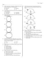
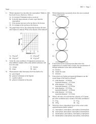
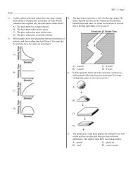
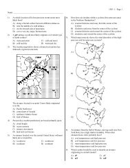
17. There is a mistake in the topographic map shown in the figure below. Identify the mistake and<br />
explain why it is wrong.<br />
Compare and contrast each pair of related terms or phrases.<br />
18. latitude, longitude<br />
19. Time zone boundaries do not always line up perfectly with lines of longitude. Why?<br />
20. Why does a Mercator projection exaggerate the areas of landmasses near the poles?<br />
21. Why are map scales useful?<br />
2<br />
www.NewYork<strong>Science</strong>Teacher.org/review
Name: ________________________<br />
ID: A<br />
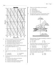
22. How does the Topex/Poseidon satellite collect data?<br />
Use the table to answer the following questions.<br />
City Latitude Longitude<br />
Cape Town, South Africa 34°S 18°E<br />
Pontianak, Indonesia 0° 109°E<br />
Nome, Alaska 65°N 165°W<br />
Quito, Ecuador 0° 79°W<br />
Stockholm, Sweden 59°N 18°E<br />
Wellington, New Zealand 41°S 175°E<br />
23. Which city is closest to the International Date Line?<br />
24. Which city is farthest from the equator?<br />
25. Suppose you were given a topographic map that did not show index contours. What would the map<br />
indicate about the terrain of the area shown? What would the map not indicate?<br />
Problem<br />
<strong>Mapping</strong> techniques can be used on other planets besides <strong>Earth</strong>. In 1996, the National Aeronautics<br />
and Space Administration (NASA) launched a satellite called the Mars Global Surveyor toward<br />
Mars. One of the purposes of the satellite was to collect data about the surface of Mars. The satellite<br />
reached Mars in 1997 and then gradually slowed into a low, circular orbit around the planet. It finally<br />
began mapping the surface of Mars in 1999, a process that was scheduled to last nearly two years.<br />
The Mars Global Surveyor carries a camera that can distinguish objects on the surface of Mars that<br />
are less than 1.5 m across. It also has an instrument that measures surface elevation as well as<br />
sensors that analyze the heat radiating from the planet’s surface. These sensors provide data about<br />
the composition of different areas of the planet. All of the information collected by the Mars Global<br />
Surveyor is transmitted to <strong>Earth</strong> in the form of radio waves. The satellite will continue to orbit Mars<br />
for at least 50 years after its mission is completed. It does not carry enough propellant to return to<br />
<strong>Earth</strong>.<br />
26. The distance from <strong>Earth</strong> to Mars ranges between 78 000 000 km and 380 000 000 km, depending on<br />
the time of year. The speed of light is 300 000 km/s. Calculate the minimum and maximum time it<br />
takes for data transmitted by the Mars Global Surveyor to reach <strong>Earth</strong>.<br />
3<br />
www.NewYork<strong>Science</strong>Teacher.org/review
Name: ________________________<br />
ID: A<br />
This map was prepared from data collected by the Mars Global Surveyor. The dashed lines on the<br />
map surround the base of the Martian volcano Olympus Mons.<br />
27. The circumference of Mars is 21 200 km. What is the approximate distance of each degree of<br />
latitude on Mars?<br />
28. How far does the base of Olympus Mons stretch from north to south? (Hint: Use your answer from<br />
question 5 to convert degrees to kilometers.)<br />
29. Can you estimate how far the base of Olympus Mons stretches from east to west with the same<br />
accuracy? Explain why or why not.<br />
30. The top of Olympus Mons is the highest point on Mars. It is 27 km above the average elevation on<br />
Mars. (Because Mars has no oceans, its elevations cannot be defined with respect to sea level.) By<br />
comparison, the highest point on <strong>Earth</strong>, Mt. Everest, is 8850 m above sea level. How many times<br />
higher than Mt. Everest is Olympus Mons?<br />
4<br />
www.NewYork<strong>Science</strong>Teacher.org/review
ID: A<br />
<strong>Mapping</strong> <strong>Short</strong> <strong>Study</strong> <strong>Guide</strong><br />
Answer Section<br />
MULTIPLE CHOICE<br />
1. A<br />
2. C<br />
3. D<br />
4. B<br />
5. D<br />
6. B<br />
7. D<br />
8. A<br />
9. C<br />
10. D<br />
MATCHING<br />
11. C<br />
12. A<br />
13. B<br />
14. F<br />
15. D<br />
SHORT ANSWER<br />
16. In a Mercator projection, the areas of landmasses near the poles are exaggerated. In a conic<br />
projection, there is very little distortion along one line of latitude, but the areas and shapes of<br />
landmasses near the top and bottom of the projection are distorted. In a gnomonic projection, the<br />
direction and distance between landmasses are distorted.<br />
17. Two contour lines cross in the upper left part of the map. This is wrong because each contour line<br />
should represent one elevation. If two lines cross, it means that the point where they cross has two<br />
elevations, which is impossible.<br />
18. Both are used to precisely locate positions on <strong>Earth</strong>. Latitude is the distance in degrees north or south<br />
of the equator. Longitude is the distance in degrees east or west of the prime meridian.<br />
19. The boundaries are adjusted in local areas to avoid the confusion that would result if, for example, a<br />
city was split by a time zone.<br />
20. Lines of longitude converge as they approach the poles, but a Mercator projection shows these lines<br />
as being parallel. Making the lines parallel stretches the area between them, especially near the poles.<br />
21. They show the relationship between distances on a map and actual distances on the surface of <strong>Earth</strong>,<br />
which enables the map reader to measure distances.<br />
1<br />
www.NewYork<strong>Science</strong>Teacher.org/review
ID: A<br />
22. The satellite sends radar waves to the ocean’s surface and picks up the echo that is reflected off the<br />
water. The distance to the water’s surface is calculated using the speed of light and the time it takes<br />
the signal to reach the surface and return. Variations in time indicate the presence of certain features<br />
on the ocean floor.<br />
23. Wellington, New Zealand<br />
24. Nome, Alaska<br />
25. The map would indicate which points on the map were higher than others and which areas were<br />
steeper. It would not indicate the actual elevation of any point.<br />
PROBLEM<br />
26. Minimum: 78 000 000 km 300 000 km/s = 260 s<br />
Maximum: 380 000 000 km 300 000 km/s = 1267 s<br />
27. 21 200 km 360° = 58.9 km/°<br />
28. The base stretches approximately 10° from north to south. 10° 58.9 km/° = 589 km<br />
29. No; lines of longitude get closer together as they approach the poles, but this map shows the lines as<br />
being parallel. Therefore, the map distorts distances in the east-west direction.<br />
30. 8850 m = 8.850 km; 27 km 8.850 km = 3; Olympus Mons is three times higher than Mt. Everest.<br />
2<br />
www.NewYork<strong>Science</strong>Teacher.org/review