GEOMORPHOLOGY REPORT - CRC LEME
GEOMORPHOLOGY REPORT - CRC LEME GEOMORPHOLOGY REPORT - CRC LEME
Site 21 1 km east of Finnegans Bridge along Dedmans drive Coordinates 0577135E 6221589N 32 m Location description Oldest floodplain meander belt, abandoned channel to south. Low open woodland of Black Box with occasional Acacia trees, saltbush understorey and pigface groundcover. Local areas bare of vegetation – possible salt scalds Site description Slight surface rise, possible residual source bordering dune on north side of abandoned channel. Soil Profile Depth (cm) Munsell colour 0-10 10YR 4/3 Loamy sand Sub-angular blocky Field Texture Structure Comments 10-20 10YR 6/2 Clay loam Sub-angular blocky 10-30 10YR 6/2 Clay loam Sub-angular blocky Surface crust; extensive fine roots; some coarse roots present; loamy sand; sub-angular blocky structure Fine and coarse roots present Fine and coarse roots present 51
Site 22 2 km east of Finnegans bridge along Dedmans drive Coordinates 05771298E 6220569N 32 m Location description Oldest floodplain meander belt with low open woodland of black box with saltbush understorey and groundcover of ephemeral herbs and pigface. Microbiotic crust. Site description Oldest floodplain meander belt, moist at depth. Soil Profile Depth (cm) Munsell colour 0-10 2.5Y 5/2 Sandy loam Sub-angular blocky Field Texture Structure Comments 10-20 10YR 4/2 Clay loam Sub-angular blocky 20-30 10YR 3/2 Clay loam Sub-angular blocky Cryptogamic crust on surface; fine roots present Fine roots present Fine roots present 52
- Page 9 and 10: List of Tables Table 1. Association
- Page 11 and 12: The main objective of the studies r
- Page 13 and 14: 4. Identification of the high recha
- Page 15 and 16: The SRTM was used as to provide the
- Page 17 and 18: Figure 6. Compartmentalisation of t
- Page 19 and 20: Dune on terrace Alluvial terrace Yo
- Page 21 and 22: Intermediate floodplain Modern floo
- Page 23 and 24: Locations of sample sites are given
- Page 25 and 26: 6.1 Granulometry 6.1.1 Methodology
- Page 27 and 28: Table 2). Mean pH and EC profiles a
- Page 29 and 30: when sampling. This is also reflect
- Page 31 and 32: Figure 12. SPOT image of Wallpolla
- Page 33 and 34: REFERENCES Bowler, J.M. and Harford
- Page 35 and 36: APPENDIX 1. ASTER data and interpre
- Page 37 and 38: APPENDIX 2. SPOT Data and interpret
- Page 39 and 40: APPENDIX 3. DEM data and interpreta
- Page 41 and 42: APPENDIX 4. Gamma-ray data 500000 (
- Page 43 and 44: APPENDIX 6. Site Descriptions and D
- Page 45 and 46: Site 3 South Settlement road, ~20 m
- Page 47 and 48: Site 5 Western end of Keera Road, s
- Page 49 and 50: Site 7 Eastern end of Old Mail Rd t
- Page 51 and 52: Site 12 Further to west along Old M
- Page 53 and 54: Site 14 Dedmens drive, across aband
- Page 55 and 56: Site 16 Same area as previous sampl
- Page 57 and 58: Site 18 Same location as 17, interm
- Page 59: Site 20 Adjacent to previous site C
- Page 64 and 65: APPENDIX 7: Analytical Results Appe
- Page 66 and 67: Appendix 7.2: Lindsay-Wallpolla Las
- Page 68 and 69: Appendix 7.3: Lindsay-Wallpolla XRF
- Page 70 and 71: 16 200709 1929587 20-30 Fm1 7 0.611
- Page 72 and 73: Site Number Depth LEME ID Sample #
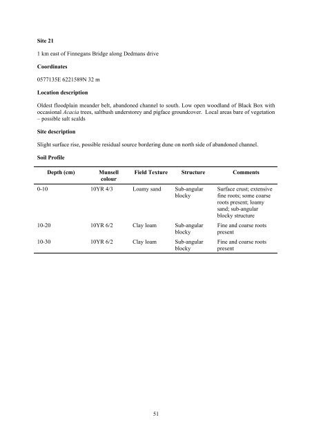
Site 21<br />
1 km east of Finnegans Bridge along Dedmans drive<br />
Coordinates<br />
0577135E 6221589N 32 m<br />
Location description<br />
Oldest floodplain meander belt, abandoned channel to south. Low open woodland of Black Box with<br />
occasional Acacia trees, saltbush understorey and pigface groundcover. Local areas bare of vegetation<br />
– possible salt scalds<br />
Site description<br />
Slight surface rise, possible residual source bordering dune on north side of abandoned channel.<br />
Soil Profile<br />
Depth (cm) Munsell<br />
colour<br />
0-10 10YR 4/3 Loamy sand Sub-angular<br />
blocky<br />
Field Texture Structure Comments<br />
10-20 10YR 6/2 Clay loam Sub-angular<br />
blocky<br />
10-30 10YR 6/2 Clay loam Sub-angular<br />
blocky<br />
Surface crust; extensive<br />
fine roots; some coarse<br />
roots present; loamy<br />
sand; sub-angular<br />
blocky structure<br />
Fine and coarse roots<br />
present<br />
Fine and coarse roots<br />
present<br />
51


