GEOMORPHOLOGY REPORT - CRC LEME
GEOMORPHOLOGY REPORT - CRC LEME GEOMORPHOLOGY REPORT - CRC LEME
from crcleme.org.au
More from this publisher
23.10.2014
Views
Vegetation map interpreted from SPOT data 29
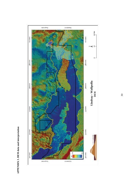
APPENDIX 3. DEM data and interpretation 30
- Page 1 and 2: CRCLEME Cooperative Research Centre
- Page 3 and 4: This report (CRC LEME Open File Rep
- Page 5 and 6: Lindsay and Wallpolla Creeks are si
- Page 7 and 8: TABLE OF CONTENTS _Toc224538156 1 I
- Page 9 and 10: List of Tables Table 1. Association
- Page 11 and 12: The main objective of the studies r
- Page 13 and 14: 4. Identification of the high recha
- Page 15 and 16: The SRTM was used as to provide the
- Page 17 and 18: Figure 6. Compartmentalisation of t
- Page 19 and 20: Dune on terrace Alluvial terrace Yo
- Page 21 and 22: Intermediate floodplain Modern floo
- Page 23 and 24: Locations of sample sites are given
- Page 25 and 26: 6.1 Granulometry 6.1.1 Methodology
- Page 27 and 28: Table 2). Mean pH and EC profiles a
- Page 29 and 30: when sampling. This is also reflect
- Page 31 and 32: Figure 12. SPOT image of Wallpolla
- Page 33 and 34: REFERENCES Bowler, J.M. and Harford
- Page 35 and 36: APPENDIX 1. ASTER data and interpre
- Page 37: APPENDIX 2. SPOT Data and interpret
- Page 41 and 42: APPENDIX 4. Gamma-ray data 500000 (
- Page 43 and 44: APPENDIX 6. Site Descriptions and D
- Page 45 and 46: Site 3 South Settlement road, ~20 m
- Page 47 and 48: Site 5 Western end of Keera Road, s
- Page 49 and 50: Site 7 Eastern end of Old Mail Rd t
- Page 51 and 52: Site 12 Further to west along Old M
- Page 53 and 54: Site 14 Dedmens drive, across aband
- Page 55 and 56: Site 16 Same area as previous sampl
- Page 57 and 58: Site 18 Same location as 17, interm
- Page 59 and 60: Site 20 Adjacent to previous site C
- Page 61 and 62: Site 22 2 km east of Finnegans brid
- Page 64 and 65: APPENDIX 7: Analytical Results Appe
- Page 66 and 67: Appendix 7.2: Lindsay-Wallpolla Las
- Page 68 and 69: Appendix 7.3: Lindsay-Wallpolla XRF
- Page 70 and 71: 16 200709 1929587 20-30 Fm1 7 0.611
- Page 72 and 73: Site Number Depth LEME ID Sample #
APPENDIX 3. DEM data and interpretation<br />
30


