GEOMORPHOLOGY REPORT - CRC LEME
GEOMORPHOLOGY REPORT - CRC LEME
GEOMORPHOLOGY REPORT - CRC LEME

You also want an ePaper? Increase the reach of your titles
YUMPU automatically turns print PDFs into web optimized ePapers that Google loves.
Question 3: Understanding of the drivers of floodplain health with respect to groundwater<br />
processes<br />
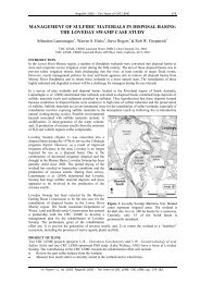
The combined LIDAR and SPOT/ASTER interpretation assisted in mapping floodplain health<br />
and allowed prediction of the geomorphic, soil, and sedimentologic parameters influencing<br />
associated with salt stores and recharge, important to the health of floodplain vegetation.<br />
Integrated products relating to floodplain health are found in the GIS and Atlas and include<br />
the Conductive Groundwater, Conductive Soils, Surface Salinity, Salinity Hazard, and Salt<br />
Store maps.<br />
Question 4: Identification of the high recharge areas in the floodplain?<br />
ASTER and LIDAR interpretation we predict will identify potential areas on the basis of<br />
abandoned or stagnant river channels or scroll bars lacking an impermeable clay drape. These<br />
will need to be field verified, however, especially as stagnant or abandoned channels may<br />
well have their bottoms sealed by clay. This would leave only the youngest meander scroll<br />
bars which lack the pervasive clay drape, or where the clay drape is very thin, as areas of high<br />
potential recharge on the floodplain. Mapping surface recharge are found in the GIS and<br />
Atlas include the Flush Zone Thickness, Flush Zone Conductivities, Extent of Flush Zones,<br />
and Groundwater Recharge maps.<br />
Question 5: What is the extent and thickness of the Blanchetown Clay and the Coonambidgal<br />
Formation?<br />
We can’t answer this question in this area from surface exposures as imaged by satellites or<br />
scanned to form DEMS. Nor are they visible in preliminary field observations. We regard<br />
this question as answerable only through a combination of AEM and bore hole data, as<br />
showing the Thickness of Quaternary Alluvium, Extent of Quaternary Alluvium, and Depth<br />
to Top of Blanchetown Clay maps in the GIS and Atlas.<br />
Question 6: Where is salt stored in the unsaturated zone?<br />
We predict that contextualised analysis of surface soil samples will help identify these areas<br />
of salt storage, backed up by analysis of shallow (above the water table) borehole samples.<br />
integrated products relating to salt stores Conductive Groundwater, Conductive Soils, Surface<br />
Salinity, Salinity Hazard, and Salt Store maps in the GIS and Atlas.<br />
23