GEOMORPHOLOGY REPORT - CRC LEME
GEOMORPHOLOGY REPORT - CRC LEME
GEOMORPHOLOGY REPORT - CRC LEME

Create successful ePaper yourself
Turn your PDF publications into a flip-book with our unique Google optimized e-Paper software.
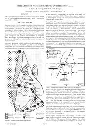
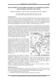
Figure 12. SPOT image of Wallpolla Creek (containing water at time imaged) and clay-lined<br />
nature of dried up channel of Wallpolla Creek as seen at ground level. Width of image is ~10 km,<br />
north to top.<br />
7.1.3 Relevance to land management questions<br />
The results of the study to date can be compared back against the six land management<br />
questions raised by Lawrie (2006). We make the following conclusions with respect to each.<br />
Question 1: What is the potential for salt mobilisation during Living Murray inundation<br />
actions?<br />
To answer this question will require integration of the surface data (LIDAR DEM, soil pits,<br />
and satellite imagery) with the results of the AEM survey and bore hole data. Integrated<br />
products relating to salt mobilisation potential are found in the GIS and Atlas, in particular the<br />
Flush Zone Thickness, Flush Zone Conductivities, Extent of Flush Zones, Groundwater<br />
Recharge, Conductive Groundwater, Conductive Soils, Surface Salinity, Salinity Hazard, and<br />
Salt Store maps.<br />
Question 2: Delivery of salt to the river<br />
To answer this question will likewise require integration of the surface data (LIDAR DEM,<br />
soil pits, and satellite imagery) with the results of the AEM survey and bore hole data to<br />
identify various potential pathways, in particular the channels along which surface and<br />
groundwater is most likely to flow. Integrated products relating to salt mobilisation potential<br />
are found in the GIS and Atlas again include the Flush Zone Thickness, Flush Zone<br />
Conductivities, Extent of Flush Zones, Groundwater Recharge, Conductive Groundwater,<br />
Conductive Soils, Surface Salinity, Salinity Hazard, and Salt Store maps.<br />
22