GEOMORPHOLOGY REPORT - CRC LEME
GEOMORPHOLOGY REPORT - CRC LEME
GEOMORPHOLOGY REPORT - CRC LEME

Create successful ePaper yourself
Turn your PDF publications into a flip-book with our unique Google optimized e-Paper software.
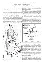
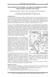
Uplands<br />
Murray River<br />
Alluvial terrace<br />
Oldest floodplain<br />
meander belt<br />
Figure 9. Vertical view of part of LIDAR DEM showing geomorphic elements. Width of image ~5<br />
km. North to top.<br />
The above geomorphic units correlate well with vegetation densities and soil types.<br />
5.2 Vegetation<br />
Billabong<br />
The distribution of different vegetation units and their relative health are critical for the<br />
identification of land management issues, soil types, and indications as to the effectiveness of<br />
management strategies. SPOT, LANDSAT and ASTER satellite imagery proved especially<br />
effective in mapping the distribution of these associations, which also corresponded well with<br />
vegetation structural units described in Specht (1981) and used to map units shown in<br />
Appendix 2. Within the Mallee region, the valleys of the Murray River, Darling River and<br />
Darling Anabranch are comparatively well vegetated with dense stands of trees and shrubs<br />
(Brown and Stephenson 1991).<br />
In the Lindsay-Wallpolla and Lake Victoria-Darling Anabranch region, the following<br />
associations were observed on the equivalent geomorphic units. The regolith landform units<br />
correlate well with vegetation densities, and with soil types (for soil type relationship see<br />
Figure 7).<br />
11