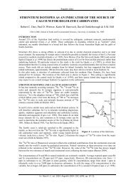
GEOMORPHOLOGY REPORT - CRC LEME
GEOMORPHOLOGY REPORT - CRC LEME
GEOMORPHOLOGY REPORT - CRC LEME

You also want an ePaper? Increase the reach of your titles
YUMPU automatically turns print PDFs into web optimized ePapers that Google loves.
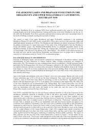
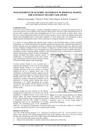
Figure 7. Diagrammatic representation of relationships between geomorphic and stratigraphic<br />
units.<br />
5.1.3 Floodplain<br />
The floodplain is formed on sediments on the Coonambidgal Formation (Butler 1958), and<br />
consists of three discrete meander belts with well developed scroll bars (Appendix 3).<br />
The oldest floodplain meander belt has a degraded scroll bar morphology. Amplitude of the<br />
scroll bars and the meander wavelength is greater for this unit that for the younger meander<br />
belts, indicating different hydraulic conditions during deposition. This unit is characterised by<br />
olive-khaki silty clay drapes over degraded scroll bars with a relief of about 2 m (Figure 8,<br />
Figure, 10). There are thin (>2 m) source bordering dunes of grey sand.<br />
There is an intermediate floodplain meander belt that has rounded morphology, with scroll<br />
bars are not as distinct as on the modern floodplain in the LIDAR DEM. Olive-khaki silty<br />
clay drapes over lower relief (~1 m) scroll bars are found in this unit. Source bordering dunes<br />
also occur on this unit.<br />
The modern floodplain consists of meander belts and high relief (2-3 m) scroll bars with crisp<br />
morphology and little or no clay draped over the surface. Scroll bars are distinct in the<br />
LIDAR DEM. Surface sediments consist largely of yellow sand.<br />
9