GEOMORPHOLOGY REPORT - CRC LEME
GEOMORPHOLOGY REPORT - CRC LEME
GEOMORPHOLOGY REPORT - CRC LEME

Create successful ePaper yourself
Turn your PDF publications into a flip-book with our unique Google optimized e-Paper software.
4. Identification of the high recharge areas in the floodplain? This relates to question 1,<br />
and means identifying areas of the floodplain where water can most easily enter from<br />
the surface i.e. high porosity permeability (sand) connected to subsurface – targets 1<br />
and 2 in Figure 3.<br />
5. What is the extent and thickness of the Blanchetown Clay and the Coonambidgal<br />
Formation? Extent and thickness of the Blanchetown Clay can be modelled in areas<br />
adjacent to the incised valley (targets 4 & 6a in Figure 3) and beneath the incised<br />
valley (targets 4 & 6b) where the conductivity contrasts between the Blanchetown<br />
Clay and the overlying Monoman Formation are high enough. Targets 1 and 2<br />
(Figure 3) can assist in the determination of the thickness and extent of<br />
Coonambidgal Formation. Drill-hole and geomorphic information will be used in the<br />
interpretation of the extent and thickness of the Coonambidgal Formation.<br />
6. Where is salt stored in the unsaturated zone? Target 7 in Figure 3.<br />
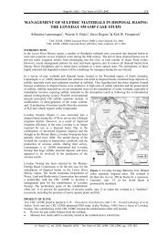
Figure 3. Conceptual model (cross-section) and proposed geophysical targets in the Lindsey –<br />
Walpolla area: WF = Woorinen Formation, CF = Coonambidgal Formation, MS = Monoman<br />
Sands, BC = Blanchetown Clay, PS = Parilla Sand (Lawrie 2006).<br />
Figure 4. Schematic hydrogeological cross-section representing the Lindsay Island reach of the<br />
Murray River Floodplain (from SKM 2004).<br />
4