GEOMORPHOLOGY REPORT - CRC LEME
GEOMORPHOLOGY REPORT - CRC LEME
GEOMORPHOLOGY REPORT - CRC LEME

Create successful ePaper yourself
Turn your PDF publications into a flip-book with our unique Google optimized e-Paper software.
metre of the ground surface (Chen 1995). The Darling River and its Anabranch also enter the<br />
Murray River in this reach at Wentworth, and approximately 15 km west of Wentworth,<br />
respectively.<br />
3 KEY LAND MANAGEMENT QUESTIONS<br />
The main identified issue in this iconic reach of the Murray River is the downstream impact<br />
of salt mobilisation during flood recessions. Research to date indicates that the Lindsay and<br />
Wallpolla Islands accumulate large amounts of salt during low flow periods and that<br />
significant floods could act to liberate much of this salt, moving it downriver where it could<br />
severely affect agricultural areas in South Australia. Accordingly, the key identified<br />
requirements are the design of an environmental watering regime and planning of<br />
revegetation strategies to optimise floodplain health and limit the salinity impact on the<br />
Murray River. This will entail gaining a more detailed understanding of the floodplain<br />
characteristics, including flush zones and salt stores. Identification of major salt influxes to<br />
the river and possible interception zones is also desired. These concerns can be expressed in<br />
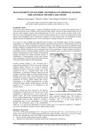
the following questions (from Lawrie 2006), with conceptual geophysical targets shown in<br />
Figure 3. Figure 4 shows a cross-section of the Murray River floodplain and Wallpolla Island.<br />
1. What is the potential for salt mobilisation during Living Murray inundation actions?<br />
This requires identifying holes in the Coonambidgal Formation – target 1. Salt stored<br />
in the sub-surface (targets 2 and 5 in the model below) may be mobilised through<br />
connected pathways to the river and surface (through targets 1 and 3). This question<br />
addresses the act of mobilisation and is therefore concerned with the source or initial<br />
position of the salt and what is causing it to move. This requires identifying high salt<br />
stores that are at risk of being mobilised. Therefore, we need to identify high<br />
conductivity salt stores, particularly in the Coonambidgal Formation and upper<br />
Monoman Formation (target 5), and we need to identify low conductivity zones<br />
where water preferentially feeds into the floodplain sediments to potentially mobilise<br />
these salt stores, namely flush zones (target 3) and floodplain recharge areas (target<br />
1). In the model below. Questions 2 and 3, below, deal with the destination of the<br />
mobilised salt. See Figure 3.<br />
2. Delivery of salt to the river. How salt is being delivered to the river requires<br />
identification of high salinity zones (similar to previous question) and relatively<br />
permeable zones or pathways for groundwater movement back to the river or<br />
anabranches once the flood recedes – targets 5, 4 and 2 in Figure 3. Salt being<br />
delivered to the river now will be interpreted from mapping salt stores (eg targets 2<br />
and 5) and their connection to the river either directly or indirectly through<br />
preferential flow paths. Additionally, salt being delivered to the river will also be<br />
mapped by identifying areas where Blanchetown Clay is thin or absent, giving rise to<br />
potential higher saline influxes to the river from saline groundwaters in the Loxton-<br />
Parilla Sands (target 4 in Figure 3).<br />
3. Understanding of the drivers of floodplain health with respect to groundwater<br />
processes. This is matter of identifying elements of floodplain and groundwater<br />
processes – targets 1, 2, 3 and 4 in the model below. This is a matter of identifying<br />
elements of floodplain composition (including salt), groundwater levels and<br />
groundwater processes. AEM can provide important baseline data in resolving this<br />
question by defining the distribution of fine and coarse grain floodplain lithologies<br />
(target: whole of floodplain, particularly top 5 metres), high salinity zones (target 5),<br />
high recharge zones (target 1), flush zones (target 3), permeable pathways delivering<br />
salt to prone areas such as anabranches and other depressions (target 2) and exposure<br />
to saline fluxes from the Parilla Sand (target 4). Recharge zones (target 1), salt stores<br />
(2 and 5) and flush zones (target 3) are conceptualised in Figure 3.<br />
3