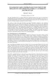
GEOMORPHOLOGY REPORT - CRC LEME
GEOMORPHOLOGY REPORT - CRC LEME
GEOMORPHOLOGY REPORT - CRC LEME

Create successful ePaper yourself
Turn your PDF publications into a flip-book with our unique Google optimized e-Paper software.
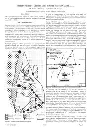
The main objective of the studies reported here is to provide information for constrained<br />
inversion of AEM data as a first step in interpreting those data to provide answers to land use<br />
questions posed by the Malee and Lower Murray-Darling Catchment Management<br />
Authorities (CMAs) for the area. The studies also provide a materials framework within<br />
which to assess the utility of the airborne electromagnetic (AEM) data to help answer the land<br />
management questions.<br />
2 PREVIOUS STUDIES<br />
There has been a paucity of geomorphic studies undertaken on the Murray Floodplain<br />
downstream Swan Hill. Those which have been undertaken relate largely to the geology and<br />
its evolution in the region, and soils and pedogenesis (Brown and Stephenson 1991; Gill<br />
1973; Macumber 1977; Hills 1975). However, a number of studies have been undertaken in<br />
the Riverine Plain of Victoria and NSW, and extrapolated to the Murray floodplain region due<br />
to similarities in their evolutionary histories (Bowler and Harford 1966; Butler et al. 1973;<br />
Pels 1966). More recently, studies have focused on the ecological or vegetation health (Jolly<br />
et al. 1993; Thoms et al. 1999) of the native vegetation. There have been few highly<br />
integrated studies in which geology, geophysics, soils, and geomorphology have been used to<br />
address questions of land management, with perhaps the study by Rowan and Downes (1963)<br />
being a notable exception. This is particularly important given that the floodplain of the<br />
Murray River in this region acts as an interface between the river and the regional<br />
groundwater systems, with the potential to mobilise large stores of salt under altered<br />
hydrological regimes.<br />
The soils of the Murray Basin are closely related to the Quaternary geology. Grey and brown<br />
soils of the Riverine Plain and solonised brown soils of the Mallee region predominate. The<br />
grey and brown soils overlie mainly the fluvial Shepparton and Coonambidgal Formations,<br />
while the solonised brown soils overlie a variety of aeolian units including the Woorinen<br />
Formation (Brown and Stephenson 1991).<br />
Previous geomorphological studies in the region have identified a number of terraces<br />
(Kotsonis et al. 1999) in the Murray Floodplain. Thoms et al. (1999) recognise that the<br />
present day channels and rivers in this region are inset within intermediate channel systems,<br />
and are therefore associated with relict floodplain surfaces that contain numerous palaeochannels<br />
and oxbow lakes. Gill (1973) named the oldest terrace the Rufus Formation.<br />
While the Riverine Plain consists of thick lacustrine and fluvatile sediments deposited mainly<br />
in the late Tertiary and Quaternary, the Mallee is a semi-arid region with extensive aeolian<br />
deposits overlying Either the Pleistocene lacustrine Blanchetown Clay or intermediate<br />
Cainozoic marine sands of the Loxton-Parilla Formation. The aeolian deposits occur in the<br />
form of two types of dunes in the Mallee. The first is a regular series of linear dunes with an<br />
east-west trend stabilised by vegetation except for the very local active sand patches. The<br />
dunes generally have calcareous B horizons, with buried palaeosols. The material of which<br />
the east-west dunes are composed of a pale to dark reddish-brown calcareous sand with some<br />
clay fraction of the Woorinen Formation (Hills 1975). The second type of dune is a complex<br />
set of parabolic and transverse dunes which are found outside of the study area.<br />
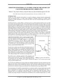
On the New South Wales side of the river Lake Victoria is a giant oxbow system lying on an<br />
anabranch formed by Frenchman’s Creek and the Rufus River, and has acted as sand trap to<br />
form a large lunette on its eastern bank which has been emplaced and remodelled over 20 000<br />
years (Gill 1973) of deflation. The river banks and sides of Lake Victoria are subjected to<br />
erosion with extensive blowouts and sandfalls, while the lunette associated with the lake is<br />
unusually wide with horizontal bedding (Gill 1973). Several salt pans exist in the vicinity of<br />
Lake Victoria, which may be relicts of a former single large lake indicated by a shallow<br />
gypsiferous layer above the Blanchetown Formation, with groundwater occurring within a<br />
2