GEOMORPHOLOGY REPORT - CRC LEME
GEOMORPHOLOGY REPORT - CRC LEME
GEOMORPHOLOGY REPORT - CRC LEME

Create successful ePaper yourself
Turn your PDF publications into a flip-book with our unique Google optimized e-Paper software.
1 INTRODUCTION<br />
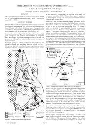
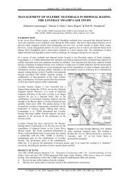
This study covers the River Murray Corridor (RMC) between Merbein and the South<br />
Australian Border (Figure 1).<br />
Figure 1. The Lindsay-Wallpolla and Lake Victoria-Darling Anabranch study area. Green boxes<br />
from left to right are for Figures 10, 9, 19, and 8, respectively.<br />
The two main areas of interest are Lindsay and Wallpolla “islands”, areas of the floodplain<br />
largely isolated by secondary anastomosing channels branching off from the Murray River,<br />
and the matching floodplain on the New South Wales side of the River. The area was visited<br />
by the authors between the 17 th and 26 th of January (Figure 2). The aim of this visit was to<br />
validate landforms units mapped on the DEM and satellite imagery and to collect soil samples<br />
for ground truthing of the physical and chemical properties of the surface materials..<br />
Figure 2. Typical landscape close to Murray River on Wallpolla Island<br />
1