CaliGeo Software(pdf) - Spectral Cameras
CaliGeo Software(pdf) - Spectral Cameras
CaliGeo Software(pdf) - Spectral Cameras

You also want an ePaper? Increase the reach of your titles
YUMPU automatically turns print PDFs into web optimized ePapers that Google loves.
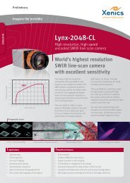
CALIGEO software<br />
<strong>CaliGeo</strong> is an advanced software package designed to process<br />
raw AISA sensor data to a format that can be read into any<br />
modern data analysis package. There it can be analyzed using<br />
any of the latest data processing and analysis methods.<br />
Processed AISA data<br />
<strong>CaliGeo</strong> runs on a standard Windows or<br />
LINUX PC as a separate module under<br />
the ENVI software package by ITT Visual<br />
Information Solutions. <strong>CaliGeo</strong> is used to perform<br />
all radiometric corrections and to rectify and<br />
georeference AISA data while ENVI provides the<br />
tools for data analysis and interpretation. The<br />
processing sequence is illustrated on the reverse<br />
page.<br />
RADIOMETRIC CORRECTIONS<br />
<strong>CaliGeo</strong> provides fast radiometric correction of<br />
the hyperspectral AISA data – including up to 500<br />
spectral bands – using the radiometric calibration<br />
data provided by SPECIM with each AISA system.<br />
To perform a quick-look at the data, extraction of any<br />
spectral or spatial subset of the data is supported,<br />
as well as dark reference subtraction, and signal –<br />
to - FODIS ratio, which gives a rough estimate on<br />
the reflectance properties of the target.<br />
GEORECTIFICATION AND<br />
GEOREFERENCING<br />
<strong>CaliGeo</strong> performs georectification and<br />
georeferencing of the AISA data by using the<br />
position and attitude data collected automatically<br />
from the GPS/INS sensor synchronously with the<br />
hyperspectral AISA data. <strong>CaliGeo</strong> also processes<br />
the collected position and attitude data into a<br />
simple ascii –format readable with any text editor<br />
thus providing a quick way to check the validity of<br />
the navigation data.<br />
Currently, data from C-MIGITS III, Applanix<br />
POS/AV series, Oxford RT3000 series and<br />
Aerocontrol GPS/INS sensors is supported in<br />
<strong>CaliGeo</strong>, as well as import of external position and<br />
attitude data. <strong>CaliGeo</strong> also provides a fast tool to<br />
remove any inaccuracies in the final, georectified<br />
images caused by sensor vs. GPS/INS sensor<br />
misalignment, i.e. the boresight errors. Similarly,<br />
<strong>CaliGeo</strong> performs fast corrections for AisaDUAL<br />
data to match the ground pixels of the VNIR and<br />
SWIR images.<br />
CALIGEO<br />
<strong>CaliGeo</strong> software,<br />
main window
<strong>Spectral</strong> Imaging Ltd.<br />
POB 110<br />
Teknologiantie 18 A<br />
FIN–90571 Oulu, Finland<br />
Tel. +358 (0)10 4244 400<br />
Fax +358 (0)8 551 4496<br />
Email info@specim.fi<br />
www.specim.fi<br />
PROCESSING SEQUENCE OF AISA SYSTEMS DATA<br />
Step 1. Raw AisaEAGLE data. The stripe<br />
on the left margin is FODIS* data<br />
for monitoring the solar irradiance.<br />
Quick turn –around time from a raw, hyperspectral AISA<br />
data into a radiometrically corrected, georectified image<br />
allows the user to concentrate on the analysis of the data.<br />
For data analysis and interpretation the ENVI software<br />
package combines a complete, advanced image processing<br />
and visualization package. The most advanced yet easy touse<br />
spectral tools are included. ENVI provides geometric<br />
correction, terrain analysis, radar analysis, raster and vector<br />
GIS capabilities, extensive support for images from a wide<br />
variety of sources, including AISA, and much more.<br />
<strong>CaliGeo</strong> requires that either the ENVI runtime version<br />
or a full version of ENVI + IDL is installed on a computer.<br />
<strong>CaliGeo</strong> does not include any of the analysis features in<br />
ENVI or IDL.<br />
FUTURE ENVI AND IDL UPGRADES AND<br />
CALIGEO VERSIONS AND SUPPORT<br />
Step 2. Radiometrically corrected<br />
AisaEAGLE data.<br />
<strong>CaliGeo</strong> runs as a plug-in in the ENVI+IDL software<br />
environment. For every new version of ENVI, SPECIM will<br />
release a version of <strong>CaliGeo</strong> that is fully compatible with<br />
it. SPECIM will also provide the latest version of <strong>CaliGeo</strong><br />
running under a limited set of older ENVI versions,<br />
depending on the interest in these versions.<br />
<strong>Spectral</strong> profile<br />
Fast reply time for support is provided in any <strong>CaliGeo</strong> –<br />
processing related questions/problems for the customers<br />
under the Annual Support Contract.<br />
Examples of the system features<br />
Step 3. Rectified and georeferenced<br />
AisaEAGLE data<br />
Images courtesy of CALMIT, Center<br />
of Advanced Land and Management<br />
Information Technologies, University<br />
of Nebraska, Lincoln, NE, U.S.A.<br />
•<br />
•<br />
•<br />
•<br />
•<br />
•<br />
•<br />
•<br />
•<br />
Option to perform full radiometric corrections to<br />
radiance or to reflectance-type FODIS ratio<br />
Extraction of any spectral or spatial subset of the data<br />
is supported<br />
Geometric correction and rectification eliminating<br />
any image distortion due to aircraft motion as well<br />
as providing output as a georeferenced hyperspectral<br />
image<br />
Fast removal of inaccuracies caused by sensor head vs.<br />
position/attitude device alignment<br />
Easy-to-use Dual sensor boresight correction to match<br />
the ground pixels of VNIR and SWIR sensors<br />
Support for use of external GPS/INS data<br />
Support for using ENVI – compatible DEM’s for<br />
optimal georectification and georeferencing accuracy<br />
Easy-to-use graphical user interface<br />
Documentation provided for main IDL subroutine<br />
calls for user-developed data processing routines<br />
*) FODIS is a Fiber Optic Downwelling Irradiance sensor manufactuered by<br />
SPECIM. For more information please contact SPECIM