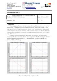
Aisa Dual, sensor - Spectral Cameras
Aisa Dual, sensor - Spectral Cameras
Aisa Dual, sensor - Spectral Cameras

Create successful ePaper yourself
Turn your PDF publications into a flip-book with our unique Google optimized e-Paper software.
aisa<br />
DUAl<br />
hyperspectral <strong>sensor</strong><br />
<strong>Aisa</strong>DUAL is a high performance hyperspectral <strong>sensor</strong> system<br />
for simultaneous acquisition of VNIR and SWIR data. <strong>Aisa</strong>DUAL<br />
combines the <strong>Aisa</strong>EAGLE and <strong>Aisa</strong>HAWK <strong>sensor</strong>s in a dual <strong>sensor</strong><br />
bracket mount and provides an economic imaging tool for remote<br />
sensing companies and researchers.<br />
<strong>Aisa</strong>HAWK<br />
(SWIR,<br />
970-<br />
2500nm)<br />
<strong>Aisa</strong>EAGLE<strong>Aisa</strong>DUAL is a compact <strong>sensor</strong>, which<br />
(VNIR, requires minimum maintenance, and<br />
400-970nm)<br />
is easy to install in a small aircraft. The<br />
<strong>sensor</strong> assembly will only require a single hole<br />
in the aircraft, and fits on a standard stabilized<br />
camera mount.<br />
In the dual <strong>sensor</strong> assembly, the <strong>Aisa</strong>HAWK<br />
<strong>sensor</strong> can be aligned with <strong>Aisa</strong>EAGLE to make<br />
both <strong>sensor</strong>s to look at the same swath on<br />
the ground. Also, the <strong>Aisa</strong>HAWK fore lens is<br />
adjustable to match the SWIR ground pixel size<br />
to that in VNIR.<br />
<strong>Aisa</strong>DUAL <strong>sensor</strong> makes a high performance<br />
hyperspectral imaging system, when integrated<br />
with an AISA data acquisition computer,<br />
RSCube software, GPS/IMU <strong>sensor</strong> and power<br />
supply. Several GPS/IMU <strong>sensor</strong>s are currently<br />
supported in the AISA systems, like C-MIGITS<br />
III, Oxford Technical Solutions RT3000 series,<br />
Applanix POS/AV series, and AeroControl GPS/<br />
IMU.<br />
CaliGeoPRO software supports the postprocessing<br />
of the <strong>Aisa</strong>DUAL <strong>sensor</strong> data.<br />
Mounted <strong>Aisa</strong>DUAL <strong>sensor</strong> system,<br />
dimensions:<br />
L: 420 mm<br />
W: 490 mm<br />
H: 680 mm<br />
Mass: 50 kg<br />
<strong>Aisa</strong>DUAL Airborne<br />
Hyperspectral Imaging System<br />
SPECIM provides <strong>Aisa</strong>DUAL as a full, ready-touse<br />
system. The complete <strong>Aisa</strong>DUAL system<br />
consists of<br />
• <strong>Aisa</strong>EAGLE and <strong>Aisa</strong>HAWK <strong>sensor</strong>s<br />
• Data Acquisition and Power Unit (DPU)<br />
with a user-friendly interface and image<br />
acquisition software (RSCube)<br />
• High performance GPS/IMU <strong>sensor</strong><br />
• CaliGeoPRO pre-processing software<br />
For more information about the complete<br />
system, please see the AISA Systems brochure.<br />
<strong>Aisa</strong>DUAL system is perfect for geolocigal applications.<br />
Sample data from Buddingtonite Outcrops, Cuprite,<br />
Nevada (Courtesy of SpecTIR LLC.)<br />
aisa hyperspectral <strong>sensor</strong>s
<strong>Spectral</strong> Imaging Ltd.<br />
POB 110<br />
Teknologiantie 18 A<br />
FIN–90571 Oulu, Finland<br />
Tel. +358 (0) 10 424 44 00<br />
Fax +358 (0)8 388 580<br />
Email info@specim.fi<br />
www.specim.fi<br />
<strong>Aisa</strong>DUAL<br />
typical specifications<br />
optical characteristics<br />
vnir<br />
swir<br />
<strong>Spectral</strong> range<br />
400-970 nm 970-2500 nm<br />
Total 400-2500 nm<br />
<strong>Spectral</strong> resolution 3.3 nm 12 nm<br />
<strong>Spectral</strong> binning options none 2x 4x none 2x 4x<br />
Number of spectral bands 244 122 60 254 127 63<br />
<strong>Spectral</strong> sampling/band (nm) 2.3 4.6 9.2 5.8 11.6 23.2<br />
FODIS (optional)<br />
In VNIR channel<br />
Calibration<br />
Sensor provided with wavelength and radiometric calibration file<br />
fore optics<br />
Swath acquisition, option 1<br />
See data acquisition option 1 on right<br />
Number of spatial pixels 320 320<br />
FOV 24 degrees 24 degrees<br />
IFOV 0.075 degrees 0.075 degrees<br />
Swath width 0.43 x altitude 0.43 x altitude<br />
Swath acquisition, option 2<br />
See data acquisition option 2 on right<br />
Number of spatial pixels 1024 320<br />
FOV 37.7 degrees 35.5 degrees<br />
IFOV 0.037 degrees 0.111 degrees<br />
Swath width 0.68 x altitude 0.64 x altitude<br />
electrical characteristics<br />
Detector CCD 12 bits MCT 14 bits<br />
SNR<br />
350:1 or 500:1 (peak) 800:1 (peak)<br />
More detailed SNR data in various conditions available from SPECIM.<br />
Integration time<br />
Adjustable, independent of frame rate<br />
Frame rate<br />
Up to 100 images/s<br />
Shutter<br />
Electromechanical shutter for dark background registration in both<br />
channels, user controllable by software.<br />
Power consumption<br />
Complete system with rack PC<br />
Complete system with lightweight PC<br />
Disclaimer: specifications are subject to change without prior notice. Any errors or omissions are unintentional.<br />
815 W<br />
695 W<br />
data acquisition options<br />
Option 1: Single computer data acquisition<br />
setup<br />
This computer setup is used to collect both<br />
the VNIR and SWIR data with the same swath<br />
width of 320 pixels. The <strong>Aisa</strong>EAGLE <strong>sensor</strong> data<br />
is spatially binned by 2 to provide 512 swath<br />
pixels. From these 512 swath pixels, 320 pixels are<br />
collected which overlap with the 320 <strong>Aisa</strong>HAWK<br />
swath pixels. The VNIR and SWIR data are<br />
combined and saved in a single image covering<br />
the spectral range of 400 to 2500 nm.<br />
This computer setup consists of a single<br />
computer with a dual input frame grabber.<br />
Images from both the <strong>Aisa</strong>EAGLE and <strong>Aisa</strong>HAWK<br />
are acquired synchronously with each other and<br />
with the GPS/IMU data.<br />
Option 2: <strong>Dual</strong> computer data acquisition setup<br />
This computer setup is used to acquire and<br />
save the full swath from both the VNIR and SWIR<br />
<strong>sensor</strong>s simultaneously with 1024 swath pixels<br />
from the <strong>Aisa</strong>EAGLE and 320 swath pixels from<br />
the <strong>Aisa</strong>HAWK. Data streams from VNIR and<br />
SWIR are saved in separate images. The VNIR<br />
and SWIR images are also processed separately<br />
in CaliGeoPRO software.<br />
This setup consists of two independent<br />
computers in a single rack. A 2-port intelligent<br />
KVM (Keyboard/Monitor/Mouse) switch is used<br />
to allow two computers to share one keyboard,<br />
one monitor and one mouse. One computer<br />
acquires VNIR data stream and another SWIR<br />
data stream. VNIR and SWIR <strong>sensor</strong>s are<br />
triggered to acquire data frames simultaneously<br />
with each other and with the GPS/IMU <strong>sensor</strong>.<br />
One of the computers is running in slave<br />
mode starting data acquisition into a file<br />
simultaneously when acquisition is started on a<br />
master computer.<br />
The optics can be selected also so that<br />
<strong>Aisa</strong>HAWK pixel size is 3 x larger than <strong>Aisa</strong>EAGLE<br />
pixel size. In this way, 320 <strong>Aisa</strong>HAWK pixels cover<br />
the same area as 960 <strong>Aisa</strong>EAGLE pixels and<br />
wider swath can be covered with both <strong>sensor</strong>s.<br />
<strong>Aisa</strong>DUAL <strong>sensor</strong> assembly, side view<br />
(<strong>Aisa</strong>EAGLE on the right, <strong>Aisa</strong>HAWK<br />
on the left)<br />
More detailed technical drawings available on request.<br />
<strong>Aisa</strong>DUAL <strong>sensor</strong> assembly, back view<br />
data storage<br />
In both of the above computer options, data is<br />
stored in a 200Gb (or larger) hot-swap hard disk<br />
during acquisition. The capacity is sufficient for<br />
ca. 4 hours of continuous acquisition.<br />
<strong>Aisa</strong>DUAL datasheet ver1-2012