DFHADprototype071409.. - Urban Drainage and Flood Control District
DFHADprototype071409.. - Urban Drainage and Flood Control District DFHADprototype071409.. - Urban Drainage and Flood Control District
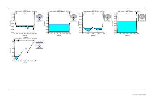
Hoffman River = RIVER-1 Reach = Mainstem RS = 295 Hoffman River = RIVER-1 Reach = Mainstem RS = 275 Culv Hoffman River = RIVER-1 Reach = Mainstem RS = 275 Culv Hoffman River = RIVER-1 Reach = Mainstem RS = 237 5094 .035 .035 .035 Legend 5094 .035 .035 .035 Legend 5092 .04 .04 .04 Legend 5092 .04 .04 .04 Legend 5092 WS 100-YEAR Ground 5092 WS 100-YEAR Ground 5090 WS 100-YEAR Ground 5090 WS 100-YEAR Ground Elevation (ft) 5090 5088 5086 Levee Bank Sta Elevation (ft) 5090 5088 5086 Levee Bank Sta Elevation (ft) 5088 5086 Bank Sta Elevation (ft) 5088 5086 Bank Sta 5084 5084 5084 5084 5082 0 50 100 150 200 250 300 350 400 5082 0 50 100 150 200 250 300 350 400 5082 0 100 200 300 400 5082 0 100 200 300 400 Station (ft) Station (ft) Station (ft) Station (ft) Hoffman River = RIVER-1 Reach = Mainstem RS = 230 Hoffman River = RIVER-1 Reach = Mainstem RS = 200 Culv Hoffman River = RIVER-1 Reach = Mainstem RS = 200 Culv Hoffman River = RIVER-1 Reach = Mainstem RS = 150 5086 .04 .04 .04 Legend 5086 .04 .04 .04 Legend 5084 .04 . 04 .04 Legend 5084 .04 . 04 .04 Legend 5084 WS 100-YEAR Ground 5084 WS 100-YEAR Ground 5082 WS 100-YEAR Ground 5082 WS 100-YEAR Ground Elevation (ft) 5082 5080 5078 Bank Sta Elevation (ft) 5082 5080 5078 Bank Sta Elevation (ft) 5080 5078 5076 Bank Sta Elevation (ft) 5080 5078 Bank Sta 5076 5076 5074 5076 5074 0 100 200 300 400 5074 0 100 200 300 400 5072 0 100 200 300 400 500 600 5074 0 100 200 300 400 500 600 Station (ft) Station (ft) Station (ft) Station (ft) Hoffman River = RIVER-1 Reach = Mainstem RS = 075 Hoffman River = RIVER-1 Reach = Railroad RS = 26824 Hoffman River = RIVER-1 Reach = Railroad RS = 26521 Hoffman River = RIVER-1 Reach = rainbow-f RS = 23141 Elevation (ft) 5084 5082 5080 5078 5076 .04 .04 .04 Legend WS 100-YEAR Ground Bank Sta Elevation (ft) 5147 5146 5145 5144 .04 . . 0 0 4 4 Legend WS 100-YEAR Ground Levee Bank Sta Elevation (ft) 5145 5144 5143 5142 5141 5140 .04 . . 00 44 Legend WS 100-YEAR Ground Levee Bank Sta Elevation (ft) 5110 5109 5108 .04 .045 .04 Legend WS 100-YEAR Ground Bank Sta 5074 5072 5143 5139 5138 5107 5070 0 100 200 300 400 500 600 5142 0 200 400 600 800 1000 5137 0 200 400 600 800 1000 1200 1400 5106 0 200 400 600 800 1000 1200 1400 1600 Station (ft) Station (ft) Station (ft) Station (ft) DFHAD Prototype
Hoffman River = RIVER-1 Reach = rainbow-f RS = 23102 Hoffman River = RIVER-1 Reach = rainbow-f RS = 23011 Hoffman River = RIVER-1 Reach = rainbow-f RS = 22415 Hoffman River = RIVER-1 Reach = rainbow-f RS = 22152 Elevation (ft) 5110.0 5109.5 5109.0 5108.5 5108.0 .04 .045 . 0 4 Legend WS 100-YEAR Ground Bank Sta Elevation (ft) 5108 5106 5104 5102 5100 . 0 3 5 .01 . 0 3 5 Legend WS 100-YEAR Ground Bank Sta Elevation (ft) 5104.0 5103.5 5103.0 5102.5 5102.0 5101.5 . 0 3 5 .035 . 0 3 5 Legend WS 100-YEAR Ground Bank Sta Elevation (ft) 5096 5094 5092 5090 5088 5086 5084 . 0 3 5 .01 . 0 3 5 Legend WS 100-YEAR Ground Bank Sta 5107.5 5098 5101.0 5082 5107.0 0 200 400 600 800 1000 1200 1400 1600 5096 0 200 400 600 800 1000 1200 1400 5100.5 0 500 1000 1500 2000 5080 0 500 1000 1500 2000 2500 3000 Station (ft) Station (ft) Station (ft) Station (ft) Hoffman River = RIVER-1 Reach = rainbow-f RS = 20229 . 5094 0 3 5 5093 .0035 .035 Legend WS 100-YEAR Ground Elevation (ft) 5092 5091 Bank Sta 5090 5089 0 500 1000 1500 2000 2500 3000 Station (ft) DFHAD Prototype
- Page 18 and 19: THIS PAGE INTENTIONALLY LEFT BLANK
- Page 20 and 21: DFHAD Prototype
- Page 22 and 23: THIS PAGE INTENTIONALLY LEFT BLANK
- Page 24 and 25: THIS PAGE INTENTIONALLY LEFT BLANK
- Page 26 and 27: THIS PAGE INTENTIONALLY LEFT BLANK
- Page 28 and 29: DFHAD Prototype VI. Problem Areas T
- Page 30 and 31: DFHAD Prototype 720 S. Colorado Bou
- Page 32 and 33: DFHAD Prototype 720 S. Colorado Bou
- Page 34 and 35: DFHAD Prototype 720 S. Colorado Bou
- Page 36 and 37: THIS PAGE INTENTIONALLY LEFT BLANK
- Page 38 and 39: THIS PAGE INTENTIONALLY LEFT BLANK
- Page 40 and 41: HOFFMAN MAJOR DRAINAGEWAY PLANNING
- Page 42 and 43: EPA SWMM Output File (100-Year) EPA
- Page 44 and 45: HOFFMAN MAJOR DRAINAGEWAY PLANNING
- Page 46 and 47: Table B-2 Peak Flow Summary Mainlin
- Page 48 and 49: DFHAD Prototype
- Page 50 and 51: DFHAD Prototype LEGEND WATERSHED BO
- Page 52 and 53: 1200 1000 800 600 400 200 0 130+00
- Page 54 and 55: Chart B-3 100-Year Hydrograph Basel
- Page 56 and 57: THIS PAGE INTENTIONALLY LEFT BLANK
- Page 58 and 59: THIS PAGE INTENTIONALLY LEFT BLANK
- Page 60 and 61: Hoffman River = RIVER-1 Reach = Rai
- Page 62 and 63: Hoffman River = RIVER-1 Reach = Mai
- Page 64 and 65: Hoffman River = RIVER-1 Reach = Mai
- Page 66 and 67: Hoffman River = RIVER-1 Reach = Mai
- Page 70 and 71: Location Structure Description Stat
- Page 72 and 73: STRUCTURE B 3.JPG STA 2+75 STRUCTUR
- Page 74 and 75: STRUCTURE D 7.JPG STA 32+50 STRUCTU
- Page 76 and 77: STRUCTURE F 11.JPG STA 47+50 STRUCT
- Page 78 and 79: STRUCTURE H 15.JPG STA 49+50 STRUCT
- Page 80 and 81: STRUCTURE J 17.JPG STA 74+75 STRUCT
- Page 82 and 83: THIS PAGE INTENTIONALLY LEFT BLANK
- Page 84 and 85: THIS PAGE INTENTIONALLY LEFT BLANK
- Page 86 and 87: REFERENCE LOCATION REACH: Mainstem
- Page 88 and 89: THIS PAGE INTENTIONALLY LEFT BLANK
- Page 91: HOFFMAN MAJOR DRAINAGEWAY PLANNING
Hoffman<br />
River = RIVER-1 Reach = rainbow-f RS = 23102<br />
Hoffman<br />
River = RIVER-1 Reach = rainbow-f RS = 23011<br />
Hoffman<br />
River = RIVER-1 Reach = rainbow-f RS = 22415<br />
Hoffman<br />
River = RIVER-1 Reach = rainbow-f RS = 22152<br />
Elevation (ft)<br />
5110.0<br />
5109.5<br />
5109.0<br />
5108.5<br />
5108.0<br />
.04 .045 .<br />
0<br />
4<br />
Legend<br />
WS 100-YEAR<br />
Ground<br />
Bank Sta<br />
Elevation (ft)<br />
5108<br />
5106<br />
5104<br />
5102<br />
5100<br />
.<br />
0<br />
3<br />
5<br />
.01 .<br />
0<br />
3<br />
5<br />
Legend<br />
WS 100-YEAR<br />
Ground<br />
Bank Sta<br />
Elevation (ft)<br />
5104.0<br />
5103.5<br />
5103.0<br />
5102.5<br />
5102.0<br />
5101.5<br />
.<br />
0<br />
3<br />
5<br />
.035 .<br />
0<br />
3<br />
5<br />
Legend<br />
WS 100-YEAR<br />
Ground<br />
Bank Sta<br />
Elevation (ft)<br />
5096<br />
5094<br />
5092<br />
5090<br />
5088<br />
5086<br />
5084<br />
.<br />
0<br />
3<br />
5<br />
.01 .<br />
0<br />
3<br />
5<br />
Legend<br />
WS 100-YEAR<br />
Ground<br />
Bank Sta<br />
5107.5<br />
5098<br />
5101.0<br />
5082<br />
5107.0<br />
0 200 400 600 800 1000 1200 1400 1600<br />
5096<br />
0 200 400 600 800 1000 1200 1400<br />
5100.5<br />
0 500 1000 1500 2000<br />
5080<br />
0 500 1000 1500 2000 2500 3000<br />
Station (ft)<br />
Station (ft)<br />
Station (ft)<br />
Station (ft)<br />
Hoffman<br />
River = RIVER-1 Reach = rainbow-f RS = 20229<br />
.<br />
5094 0<br />
3<br />
5<br />
5093<br />
.0035 .035<br />
Legend<br />
WS 100-YEAR<br />
Ground<br />
Elevation (ft)<br />
5092<br />
5091<br />
Bank Sta<br />
5090<br />
5089<br />
0 500 1000 1500 2000 2500 3000<br />
Station (ft)<br />
DFHAD Prototype


