- Page 3 and 4:
Urban Storm Drainage Criteria Manua
- Page 5 and 6:
Table of Contents Urban Storm Drain
- Page 7:
Disclaimer Attention all persons us
- Page 11 and 12:
Preface 1.0 Acknowledgements The Ur
- Page 13 and 14:
Preface 2.0 Purpose Volume 3 of the
- Page 15 and 16:
Preface • Glossary: A glossary is
- Page 17 and 18:
Preface fps ft FHWA GB GS H:V HSG F
- Page 19:
Chapter 1 Stormwater Management and
- Page 22 and 23:
Stormwater Management and Planning
- Page 24 and 25:
Stormwater Management and Planning
- Page 26 and 27:
Stormwater Management and Planning
- Page 28 and 29:
Stormwater Management and Planning
- Page 30 and 31:
Stormwater Management and Planning
- Page 32 and 33:
Stormwater Management and Planning
- Page 34 and 35:
Stormwater Management and Planning
- Page 36 and 37:
Stormwater Management and Planning
- Page 38 and 39:
Stormwater Management and Planning
- Page 40 and 41:
Stormwater Management and Planning
- Page 43:
Chapter 2 BMP Selection Contents 1.
- Page 46 and 47:
BMP Selection Chapter 2 area is too
- Page 48 and 49:
BMP Selection Chapter 2 provided by
- Page 50 and 51:
BMP Selection Chapter 2 Table 2-2.
- Page 52 and 53:
BMP Selection Chapter 2 1.4 Storage
- Page 54 and 55:
BMP Selection Chapter 2 1.8 Online
- Page 56 and 57:
BMP Selection Chapter 2 reflect the
- Page 58 and 59:
BMP Selection Chapter 2 Figure 2-2.
- Page 60 and 61:
BMP Selection Chapter 2 3.0 Life Cy
- Page 62 and 63:
BMP Selection Chapter 2 5.0 Referen
- Page 64 and 65:
Figure 3-15. Colorado Green Impervi
- Page 66 and 67:
Calculating the WQCV and Volume Red
- Page 68 and 69:
Calculating the WQCV and Volume Red
- Page 70 and 71:
Calculating the WQCV and Volume Red
- Page 72 and 73:
Calculating the WQCV and Volume Red
- Page 74 and 75:
Calculating the WQCV and Volume Red
- Page 76 and 77:
Calculating the WQCV and Volume Red
- Page 78 and 79:
Calculating the WQCV and Volume Red
- Page 80 and 81:
Calculating the WQCV and Volume Red
- Page 82 and 83:
Calculating the WQCV and Volume Red
- Page 84 and 85:
Calculating the WQCV and Volume Red
- Page 86 and 87:
Calculating the WQCV and Volume Red
- Page 88 and 89:
Calculating the WQCV and Volume Red
- Page 90 and 91:
Calculating the WQCV and Volume Red
- Page 92 and 93:
Calculating the WQCV and Volume Red
- Page 94 and 95:
Calculating the WQCV and Volume Red
- Page 96 and 97:
Calculating the WQCV and Volume Red
- Page 98 and 99:
Calculating the WQCV and Volume Red
- Page 101:
Chapter 4 Treatment BMPs Contents 1
- Page 104 and 105:
Treatment BMPs Chapter 4 2.0 Treatm
- Page 106 and 107:
Treatment BMPs Chapter 4 3.0 Refere
- Page 109 and 110:
Grass Buffer T-1 4. Buffer Slope: T
- Page 111 and 112:
Grass Buffer T-1 Turf grasses such
- Page 113 and 114:
Grass Buffer T-1 Figure GB-2. Typic
- Page 115:
Grass Buffer T-1 References Barrett
- Page 118 and 119:
T-2 Grass Swale • Provide access
- Page 120 and 121:
T-2 Grass Swale 8. Underdrain: An u
- Page 122 and 123:
T-2 Grass Swale Figure GS-1. Grass
- Page 124 and 125:
T-2 Grass Swale References Chow, Ve
- Page 126:
T-3 Bioretention Site Selection Bio
- Page 130 and 131:
T-3 Bioretention Table B-1. Class 1
- Page 133 and 134:
Bioretention T-3 Pipe Diameter Tabl
- Page 135 and 136:
Bioretention T-3 6. Inlet/Outlet Co
- Page 137 and 138:
Bioretention T-3 Table B-6. Native
- Page 139 and 140:
Bioretention T-3 Figure B-1 - Typic
- Page 141 and 142:
Bioretention T-3 November 2010 Urba
- Page 143 and 144:
Bioretention T-3 Figure B-2. Geomem
- Page 145 and 146:
Bioretention T-3 Construction Examp
- Page 147 and 148:
Bioretention T-3 Design Example The
- Page 149:
Bioretention T-3 Design Procedure F
- Page 152 and 153:
T-4 Green Roof reduction benefits o
- Page 154:
T-4 Green Roof Figure GR-1. Typical
- Page 157 and 158:
Green Roof T-4 6. Planting Method:
- Page 159 and 160:
Green Roof T-4 Additional Design Gu
- Page 161 and 162:
Green Roof T-4 Colorado Examples Th
- Page 163 and 164:
Extended Detention Basin (EDB) T-5
- Page 166:
T-5 Extended Detention Basin (EDB)
- Page 170 and 171: T-5 Extended Detention Basin (EDB)
- Page 172 and 173: T-5 Extended Detention Basin (EDB)
- Page 174 and 175: T-5 Extended Detention Basin (EDB)
- Page 176 and 177: T-5 Extended Detention Basin (EDB)
- Page 178 and 179: T-5 Extended Detention Basin (EDB)
- Page 180: T-6 Sand Filter adjacent structures
- Page 184 and 185: T-6 Sand Filter 5. Impermeable Geom
- Page 186 and 187: T-6 Sand Filter Figure SF-1. Sand F
- Page 188 and 189: T-6 Sand Filter Design Examples The
- Page 191 and 192: Retention Pond T-7 Description A re
- Page 195 and 196: Retention Pond T-7 H = depth of sur
- Page 197 and 198: Retention Pond T-7 Aesthetic Design
- Page 199 and 200: Retention Pond T-7 Design Example F
- Page 201 and 202: Retention Pond T-7 Design Procedure
- Page 203: Retention Pond T-7 References Bedie
- Page 206: T-8 Constructed Wetland Pond be des
- Page 210 and 211: T-8 Constructed Wetland Pond Figure
- Page 212 and 213: T-8 Constructed Wetland Pond Design
- Page 214 and 215: T-8 Constructed Wetland Pond Refere
- Page 216 and 217: T-9 Constructed Wetland Channel A c
- Page 218 and 219: T-9 Constructed Wetland Channel Fig
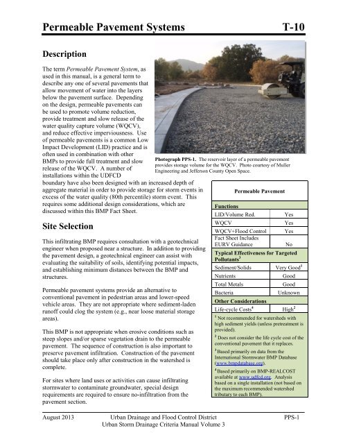
- Page 222 and 223: T-10 Permeable Pavement Systems Per
- Page 224 and 225: T-10 Permeable Pavement Systems •
- Page 226 and 227: T-10 Permeable Pavement Systems Fig
- Page 228 and 229: T-10 Permeable Pavement Systems Fig
- Page 230 and 231: T-10 Permeable Pavement Systems att
- Page 232 and 233: T-10 Permeable Pavement Systems mem
- Page 234 and 235: T-10 Permeable Pavement Systems For
- Page 236 and 237: T-10 Permeable Pavement Systems Fig
- Page 238 and 239: T-10 Permeable Pavement Systems Fig
- Page 240 and 241: T-10 Permeable Pavement Systems Con
- Page 242 and 243: T-10 Permeable Pavement Systems Des
- Page 244 and 245: T-10.1 Permeable Interlocking Concr
- Page 246 and 247: T-10.1 Permeable Interlocking Concr
- Page 248 and 249: T-10.1 Permeable Interlocking Concr
- Page 250 and 251: T-10.2 Concrete Grid Pavement Desig
- Page 253 and 254: Porous Gravel T-10.4 Note: This BMP
- Page 255 and 256: Reinforced Grass T-10.5 Note: This
- Page 257 and 258: Underground BMPs T-11 Description U
- Page 259 and 260: Underground BMPs T-11 Site Selectio
- Page 261 and 262: Underground BMPs T-11 Questions to
- Page 263 and 264: Underground BMPs T-11 To evaluate p
- Page 265 and 266: Underground BMPs T-11 Depending on
- Page 267 and 268: Outlet Structures T-12 Description
- Page 269 and 270: Outlet Structures T-12 Table OS-1.
- Page 271 and 272:
Outlet Structures T-12 Table OS-2a.
- Page 273 and 274:
Outlet Structures T-12 Table OS-3b.
- Page 275 and 276:
Outlet Structures T-12 Micropools w
- Page 277 and 278:
Outlet Structures T-12 Figure OS-4.
- Page 279 and 280:
Outlet Structures T-12 Figure OS-6.
- Page 281:
Outlet Structures T-12 Figure OS-8.
- Page 285 and 286:
Chapter 5 Source Control BMPs 1.0 I
- Page 287 and 288:
Chapter 5 Source Control BMPs 2.0 S
- Page 289 and 290:
Chapter 5 Source Control BMPs Table
- Page 291 and 292:
Chapter 5 Source Control BMPs Table
- Page 293 and 294:
Covering Outdoor Storage and Handli
- Page 295 and 296:
Spill Prevention, Containment and C
- Page 297 and 298:
Spill Prevention, Containment and C
- Page 299 and 300:
Disposal of Household Waste S-3 Des
- Page 301 and 302:
Disposal of Household Waste S-3 Pra
- Page 303 and 304:
Illicit Discharge Controls S-4 Desc
- Page 305:
Illicit Discharge Controls S-4 Prev
- Page 308 and 309:
S-5 Good Housekeeping • Routinely
- Page 311:
Preventative Maintenance S-6 Descri
- Page 314 and 315:
S-7 Vehicle Maintenance, Fueling an
- Page 317 and 318:
Use of Pesticides, Herbicides and F
- Page 319 and 320:
Use of Pesticides, Herbicides and F
- Page 321:
Use of Pesticides, Herbicides and F
- Page 324 and 325:
S-9 Landscape Maintenance Lawn Aera
- Page 326 and 327:
S-9 Landscape Maintenance • If po
- Page 329 and 330:
Snow and Ice Management S-10 Descri
- Page 331 and 332:
Snow and Ice Management S-10 Table
- Page 333 and 334:
Street Sweeping and Cleaning S-11 D
- Page 335 and 336:
Storm Sewer System Cleaning S-12 De
- Page 337 and 338:
Chapter 6 BMP Maintenance Contents
- Page 339 and 340:
Chapter 6 BMP Maintenance 1.0 Intro
- Page 341 and 342:
Chapter 6 BMP Maintenance component
- Page 343 and 344:
Chapter 6 BMP Maintenance 4.0 Grass
- Page 345 and 346:
Chapter 6 BMP Maintenance 4.7 Sedim
- Page 347 and 348:
Chapter 6 BMP Maintenance 6.0 Green
- Page 349 and 350:
Chapter 6 BMP Maintenance 7.2 Debri
- Page 351 and 352:
Chapter 6 BMP Maintenance 8.2 Debri
- Page 353 and 354:
Chapter 6 BMP Maintenance 10.3 Aqua
- Page 355 and 356:
Chapter 6 BMP Maintenance material
- Page 357 and 358:
Chapter 7 Construction BMPs Content
- Page 359:
Figures Figure 7-1. Components of E
- Page 362 and 363:
Construction BMPs Construction BMPs
- Page 364 and 365:
Construction BMPs Construction BMPs
- Page 366 and 367:
Construction BMPs Construction BMPs
- Page 368 and 369:
Construction BMPs Construction BMPs
- Page 370 and 371:
Construction BMPs Construction BMPs
- Page 372 and 373:
Construction BMPs Construction BMPs
- Page 374 and 375:
Construction BMPs Construction BMPs
- Page 376 and 377:
Construction BMPs Construction BMPs
- Page 378 and 379:
Chapter 7 Construction BMPs • For
- Page 380 and 381:
Chapter 7 Construction BMPs 5.2 Slo
- Page 382 and 383:
Chapter 7 Construction BMPs obtain
- Page 384 and 385:
Chapter 7 Construction BMPs built a
- Page 386 and 387:
Chapter 7 Construction BMPs The loc
- Page 388 and 389:
Chapter 7 Construction BMPs • Spa
- Page 391 and 392:
Construction BMP Plan Symbols Novem
- Page 393 and 394:
Construction BMP Plan Symbols Novem
- Page 395:
Construction BMP Plan Symbols Novem
- Page 398 and 399:
EC-1 Surface Roughening (SR) Mainte
- Page 400 and 401:
EC-1 Surface Roughening (SR) SR-4 U
- Page 402 and 403:
EC-2 Temporary and Permanent Seedin
- Page 404 and 405:
EC-2 Temporary and Permanent Seedin
- Page 406 and 407:
EC-2 Temporary and Permanent Seedin
- Page 408 and 409:
EC-3 Soil Binders (SB) Table SB-1.
- Page 410 and 411:
EC-3 Soil Binders (SB) o For sandy
- Page 412 and 413:
EC-3 Soil Binders (SB) Areas where
- Page 414 and 415:
EC-4 Mulching (MU) • Clean, weed-
- Page 416 and 417:
EC-5 Compost Blanket and Filter Ber
- Page 418 and 419:
EC-5 Compost Blanket and Filter Ber
- Page 420 and 421:
EC-6 Rolled Erosion Control Product
- Page 422 and 423:
EC-6 Rolled Erosion Control Product
- Page 424 and 425:
EC-6 Rolled Erosion Control Product
- Page 426 and 427:
EC-6 Rolled Erosion Control Product
- Page 429 and 430:
Temporary Slope Drains (TSD) EC-7 D
- Page 431 and 432:
Temporary Slope Drains (TSD) EC-7 N
- Page 433 and 434:
Temporary Outlet Protection (TOP) E
- Page 435:
Temporary Outlet Protection (TOP) E
- Page 438 and 439:
EC-9 Rough Cut Street Control (RCS)
- Page 441 and 442:
Earth Dikes and Drainage Swales (ED
- Page 443 and 444:
Earth Dikes and Drainage Swales (ED
- Page 445:
Earth Dikes and Drainage Swales (ED
- Page 448 and 449:
EC-11 Terracing (TER) TER-2 Urban D
- Page 450 and 451:
EC-12 Check Dams (CD) Design detail
- Page 452 and 453:
EC-12 Check Dams (CD) CD-4 Urban Dr
- Page 454 and 455:
EC-12 Check Dams (CD) CD-6 Urban Dr
- Page 456 and 457:
EC-13 Streambank Stabilization (SS)
- Page 459 and 460:
Concrete Washout Area (CWA) MM-1 De
- Page 461 and 462:
Concrete Washout Area (CWA) MM-1 No
- Page 463 and 464:
Stockpile Management (SP) MM-2 Desc
- Page 465 and 466:
Stockpile Management (SP) MM-2 Nove
- Page 467 and 468:
Stockpile Management (SP) MM-2 Nove
- Page 469 and 470:
Good Housekeeping Practices (GH) MM
- Page 471 and 472:
Good Housekeeping Practices (GH) MM
- Page 473 and 474:
Good Housekeeping Practices (GH) MM
- Page 475 and 476:
Silt Fence (SF) SC-1 Description A
- Page 477 and 478:
Silt Fence (SF) SC-1 November 2010
- Page 479 and 480:
Sediment Control Log (SCL) SC-2 Des
- Page 481 and 482:
Sediment Control Log (SCL) SC-2 Nov
- Page 483:
Sediment Control Log (SCL) SC-2 Nov
- Page 486 and 487:
SC-3 Straw Bale Barrier (SBB) SBB-2
- Page 489 and 490:
Brush Barrier (BB) SC-4 Description
- Page 491 and 492:
Rock Sock (RS) SC-5 Description A r
- Page 493:
Rock Sock (RS) SC-5 November 2010 U
- Page 496 and 497:
SC-6 Inlet Protection (IP) IP-3. Ro
- Page 498 and 499:
SC-6 Inlet Protection (IP) IP-4 Urb
- Page 500 and 501:
SC-6 Inlet Protection (IP) IP-6 Urb
- Page 502 and 503:
SC-6 Inlet Protection (IP) IP-8 Urb
- Page 504 and 505:
SC-7 Sediment Basin (SB) • Inflow
- Page 506 and 507:
SC-7 Sediment Basin (SB) Maintenanc
- Page 508 and 509:
SC-7 Sediment Basin (SB) SB-6 Urban
- Page 511 and 512:
Sediment Trap (ST) SC-8 Description
- Page 513:
Sediment Trap (ST) SC-8 November 20
- Page 517 and 518:
Chemical Treatment (CT) SC-10 Descr
- Page 519 and 520:
Construction Phasing/Sequencing (CP
- Page 521 and 522:
Construction Phasing/Sequencing (CP
- Page 523 and 524:
Protection of Existing Vegetation (
- Page 525:
Protection of Existing Vegetation (
- Page 528 and 529:
SM-3 Construction Fence (CF) CF-2 U
- Page 531 and 532:
Vehicle Tracking Control (VTC) SM-4
- Page 533 and 534:
Vehicle Tracking Control (VTC) SM-4
- Page 535 and 536:
Vehicle Tracking Control (VTC) SM-4
- Page 537:
Stabilized Construction Roadway (SC
- Page 540 and 541:
SM-6 Stabilized Staging Area (SSA)
- Page 542 and 543:
SM-6 Stabilized Staging Area (SSA)
- Page 545 and 546:
Temporary Diversion Methods (TDM) S
- Page 547 and 548:
Temporary Diversion Methods (TDM) S
- Page 549 and 550:
Temporary Diversion Methods (TDM) S
- Page 551 and 552:
Temporary Diversion Methods (TDM) S
- Page 553 and 554:
Temporary Diversion Methods (TDM) S
- Page 555 and 556:
Temporary Diversion Methods (TDM) S
- Page 557:
Temporary Diversion Methods (TDM) S
- Page 560 and 561:
SM-9 Dewatering Operations (DW) Dew
- Page 562 and 563:
SM-9 Dewatering Operations (DW) DW-
- Page 565 and 566:
Temporary Stream Crossing (TSC) SM-
- Page 567 and 568:
Temporary Stream Crossing (TSC) SM-
- Page 569 and 570:
Temporary Stream Crossing (TSC) SM-
- Page 571 and 572:
Temporary Batch Plant (TBP) SM-11 D
- Page 573:
Paving and Grinding Operations (PGO
- Page 576 and 577:
Glossary Clean Water Act: Federal l
- Page 578 and 579:
Glossary Forebay: Storage space loc
- Page 580 and 581:
Glossary Peak Runoff Rate: The high
- Page 582 and 583:
Glossary Surface Water: Water that
- Page 584 and 585:
Bibliography Colorado State Univers
- Page 586 and 587:
Bibliography Guo, James C.Y., E. G.
- Page 588 and 589:
Bibliography Roesner, L.A. and B.P.