
Create successful ePaper yourself
Turn your PDF publications into a flip-book with our unique Google optimized e-Paper software.
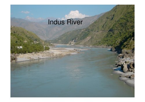
<strong>Indus</strong> <strong>River</strong><br />
<strong>Indus</strong> <strong>River</strong>
World map
Map
Begins as an icy stream in Himalayas<br />
Facts about the <strong>River</strong>
Facts about the <strong>River</strong><br />
• Begins as an icy stream in Himalayas<br />
• Major river of Pakistan<br />
• Five Other rivers<br />
• Flow of the river varies; minimum (December to February) and maximum<br />
(July to September)<br />
• Main supply of drinking water in Pakistan<br />
• Provides key water resources for the economy of Pakistan<br />
• Length 3200 km<br />
• Total Drainage area 1,165,000 km square<br />
• Largest river in Pakistan, 9 th in Asia and 21 st in the World<br />
• One of the few rivers that exhibit a tidal bore
<strong>River</strong> Characteristics<br />
• Length 1,800 miles<br />
• Total drainage area 450,000 square miles<br />
• 175,000 square miles is in Himalayan ranges<br />
• Annual flow rate is about 207 billion cubic metres<br />
• Twice that of Nile river<br />
• Depth is 15,000 to 17,000 feet or 4,600 to 5,200 metres<br />
• Width is 12 to 16 miles<br />
• Average discharge 6,600 cubic metres per seconds<br />
• Main tributaries: Jhelum, Sutlej, Beas, Ravi and Chenab<br />
• Source: Singikabab, <strong>River</strong> Sutlej, Gar rivers
Water Level and supply<br />
• Water level is at its lowest from mid<br />
December to mid February<br />
• Annually the upper <strong>Indus</strong> carries about 110<br />
billion cubic metres
Geology
Geology<br />
• Feeds the <strong>Indus</strong> submarine fan<br />
• 5 million cubic kilometres<br />
• 5 million years ago <strong>Indus</strong> river was connected<br />
to the <strong>River</strong> Ganges in India<br />
• Massive amounts of erosion are bringing<br />
lower crustal rocks to the surface
Geology
Plant and Wildlife
Plant and Wildlife<br />
• In Sindh on the lower <strong>Indus</strong>, desert conditions<br />
prevail 10 to 25 miles away from the river<br />
• Area is dominated by sand and poor grass<br />
cover.
Effects of climate change in the river<br />
• Tibetan Plateau contains the world’s 3 rd largest<br />
store of ice<br />
• Temperatures are rising four times faster than<br />
elsewhere in China, and the Tibetan glaciers are<br />
retreating at a higher speed than in any other<br />
part of the world... In the short term, this will<br />
cause lakes to expand and bring floods and<br />
mudflows.. In the long run, the glaciers are vital<br />
lifelines of the <strong>Indus</strong> <strong>River</strong>. Once they vanish,<br />
water supplies in Pakistan will be in peril.”
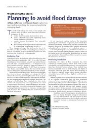
Flooding<br />
• Prone to flooding in summer<br />
• Floods are unpredictable<br />
• During flood the banks of the river can<br />
collapse
2010 flood
2010 Flood<br />
• Abnormally heavy monsoon rains<br />
• Rain continued for the next two months<br />
• Western Punjab area where about 570,000ha<br />
of cropland was destroyed
Places affected by flood
Flood Disaster summary<br />
• More than 20 million people have been affected,<br />
and the toll is rising.<br />
• Thousands of people have been killed or injured.<br />
• 3.5 million children face waterborne diseases.<br />
• A quarter of Pakistan land area, including its<br />
agricultural heartland, has been inundated.<br />
• Up to 3.5 million hectares of crops have been<br />
destroyed.<br />
• At least a million homes destroyed or damaged.
Flood control in Pakistan<br />
• Pakistan doesn’t have a flood control system due to lack of storage<br />
capacity and absence of known practical options<br />
• Existing dams and proposed kalabagh dam is too small to handle<br />
the amount of inflow in 2010 flood<br />
• Kalabagh could have stored only 7.5% of total water but not<br />
without upstream damage in Nowshera and above<br />
• In future, due to global warming, region expects increased<br />
frequency and intensity of flash floods coupled with higher glacier<br />
melt runoff.<br />
• In the absence of a comprehensive plan, such floods can hit the<br />
backbone of country’s economy after every few years<br />
• This was not the last flood. Floods will most likely happen again, in a<br />
year, or a decade or later. No one can say it will never happen again.
Pakistan Flood Control System (PFCS)<br />
• Some options have been suggested by Pakistan Flood<br />
Control System<br />
• PFCS is a flood control system designed for Pakistan<br />
that offers control for extreme floods in the <strong>Indus</strong> river.<br />
• It contains a system of five dams for flood control<br />
(Soan, Rohtas, Khyber, Bhit and Nari Bolan) and three<br />
canals. (Soan link Canal, Grand <strong>Indus</strong> canal and<br />
optional Makran Canal)<br />
• Soan Dam is the core of PFCS, Other dams will help but<br />
Soan dam alone can successfully handle floods like<br />
2010
Pakistan Flood Control System (PFCS)<br />
• Soan dam sets foundation for radical changes in Pakistan’s flood<br />
control and irrigation paradigm by allowing distributed system of<br />
large local multipurpose projects, Dynamic allocation of water and<br />
coordinated flood harvesting are some of the other main features<br />
• Proposed dams increase water storage capacity of Pakistan by<br />
64.4%. Apart from total flood control, PFCS will play a role of<br />
“Water bank of Pakistan”, to ensure right amount of water at right<br />
time for all provinces, according to already defined respective water<br />
share.<br />
• PFCS is designed around historical peak floods in country with 50%<br />
plus safety factor<br />
• Last but not least, PFCS doesn’t need the Kalabagh dam. Instead it<br />
adresses Kalabagh dam’s potential drawbacks positively due to<br />
effective flood control in all four provinces, lack of water diversion<br />
and decentralization of water & Power storage
A look around the world<br />
• What has been done to prevent flooding
Prevents flooding in England
Prevents flood in Japan
Preventing flood in Holland
Preventing flood in Holland or<br />
Netherland
Pakistan Flood Control System (PFCS)<br />
• By taking solid steps, Pakistan can change such<br />
disasters into a blessing by saving possibly<br />
$30-50 billions of flood damage per decade<br />
and earning much bigger amount by increased<br />
agricultural productivity, extra power<br />
generation and food security
Thank You