CHAPTER 14 - Iskandar Malaysia
CHAPTER 14 - Iskandar Malaysia
CHAPTER 14 - Iskandar Malaysia

You also want an ePaper? Increase the reach of your titles
YUMPU automatically turns print PDFs into web optimized ePapers that Google loves.
SECTION B<br />
PLANNING AND IMPLEMENTATION<br />
No River Location Affected Flooding<br />
people<br />
4. Sungai<br />
Plentong<br />
• Kg. Plentong Baru 120 -<br />
D. Application of MASMA<br />
The MASMA Manual for run-off design promotes environmentally friendly<br />
solutions and should be made applicable to any development in Johor<br />
Bahru.<br />
5. Others • Kg. Oren<br />
• Jalan Air Molek<br />
• Kg. Mohd. Amin<br />
• Rumah Murah Melati,<br />
Ulu Tiram<br />
500 Every 2<br />
years<br />
TOTAL 8,966<br />
Sources: Laporan Banjir Disember 2001, JPS Johor & Media<br />
E. Rehabilitation of Major River and Straits of Johor<br />
Major rehabilitation of rivers such as Sungai Skudai and Sungai Tebrau<br />
should be carried out to prevent erosion and siltation caused by the<br />
construction of major embankment work, to improve water quality.<br />
This work should also be carried out along the coastal areas of SJER<br />
stretching from east to west.<br />
The main reason of flooding in this area is due to insufficient capacity to<br />
receive the additional discharge. Some of the rivers meander and as a<br />
result, siltation easily occurs at the river mouth, causing flood. The situation<br />
become worse when there is heavy rain and high spring tide. The rapid<br />
pace of development within the district of Johor Bahru also contributes<br />
to the flooding at the river basin area, as insufficient drainage causes<br />
blockages and flash flood.<br />
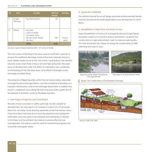
Illegal Squatters Within The Reserve<br />
of Sungai Skudai<br />
Example of an Embankment Work<br />
The presence of illegal squatters within the river reserve areas, especially<br />
at Sungai Skudai and Sungai Tebrau, can also contribute to flooding, as it<br />
impedes maintenance work by the drainage department. In addition this<br />
results in unpleasant views along the rivers and poor water quality due to<br />
the disposal of domestic waste by the illegal squatters.<br />
Figure <strong>14</strong>.4: Application of Sustainable Drainage<br />
Grass area<br />
Absorbs rain water<br />
into the ground<br />
C. New Target of Projection and Commitment<br />
The rate of land conversion in SJER is quite high. As sites cleared for<br />
development, this may result in an increase in surface run off and peak<br />
flows that can easily cause flooding; especially at the river estuary. Many<br />
rivers have been narrowed due to land development and subsequent<br />
Rain water<br />
harvesting<br />
Gravel<br />
Trench’<br />
Soakaway<br />
Pit’<br />
Porous road<br />
surface<br />
Swale<br />
Gross pollutant<br />
Trap<br />
(GPT)<br />
Traps waste<br />
Retention<br />
Pond and<br />
‘Wetland’<br />
Retain surface<br />
run-off water<br />
water<br />
earthworks, and may need to be widened and maintained. In relation<br />
to this there must be sufficient river reserve to ensure effective river<br />
management. The reserve could be used for recreational purposes and<br />
Source: SJER CDP 2025<br />
to provide more green areas.<br />
<strong>14</strong> - 12