View a PDF version of the guide - Auckland Transport
View a PDF version of the guide - Auckland Transport
View a PDF version of the guide - Auckland Transport

Create successful ePaper yourself
Turn your PDF publications into a flip-book with our unique Google optimized e-Paper software.
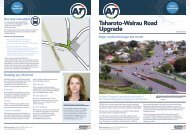
Guide to travelling to<br />
and around Panmure<br />
April 2013
AMETI Phase One Construction<br />
2<br />
2
This <strong>guide</strong> provides an overview <strong>of</strong> travel options<br />
to and through <strong>the</strong> Panmure area as construction<br />
proceeds on <strong>the</strong> AMETI project.<br />
Please note that as construction progresses some arrangements will change.<br />
Go to www.aucklandtransport.govt.nz for <strong>the</strong> latest updates.<br />
AMETI is a group <strong>of</strong> transport projects for <strong>the</strong> eastern suburbs that will give travellers<br />
greater choice by improving public transport, walking and cycling facilities and reducing<br />
traffic congestion. AMETI will also unlock <strong>the</strong> economic potential <strong>of</strong> <strong>the</strong> area by improving<br />
strategic transport links.<br />
AMETI Panmure involves a number <strong>of</strong> major projects, which are mostly underway.<br />
These includes:<br />
Project<br />
Intended work<br />
Pedestrian Plaza • Now open<br />
Mountain Road bridge<br />
replacement and<br />
realignment <strong>of</strong> road to<br />
Jellicoe/Pleasant <strong>View</strong> Rd<br />
intersection<br />
• Now open, speed restrictions in place<br />
Panmure Station Upgrade • Construction <strong>of</strong> <strong>the</strong> new station building and o<strong>the</strong>r<br />
improvements until 2014<br />
Busway bridge<br />
completion and Ellerslie<br />
Panmure Highway bridge<br />
replacement<br />
• Northbound traffic to Glen Innes diverted via<br />
Forgeway from 28 October 2012 to August 2013<br />
• Ellerslie-Panmure Highway traffic diverted to busway<br />
bridge 25 November 2012 to August 2013<br />
• November to Christmas 2012 Ellerslie Panmure<br />
Highway bridge demolished<br />
• New Ellerslie Panmure Highway bridge built from late<br />
2012 to August 2013<br />
• Ellerslie Panmure Highway bridge operational about<br />
August 2013. Busway bridge operational for buses<br />
late 2013<br />
AMETI Link Road • Construction <strong>of</strong> new road north - south 2013 - 2014<br />
• Tunnel for new road 2012-2013<br />
Fur<strong>the</strong>r details on AMETI and updates on <strong>the</strong> construction activities around Panmure can<br />
be found here. www.aucklandtransport.govt.nz/ameti<br />
3
Travelling around <strong>the</strong> area on foot<br />
Please be aware <strong>the</strong>re are changes to pedestrian access in <strong>the</strong> area, particularly around<br />
Panmure Station, while construction is underway. This includes <strong>the</strong> closure <strong>of</strong> <strong>the</strong> Ellerslie<br />
Panmure Highway footpath on <strong>the</strong> south side between Panmure Roundabout and Forge Way.<br />
Major improvements for pedestrians, including a number <strong>of</strong> upgrads <strong>of</strong> new footpaths, are<br />
being made as part <strong>of</strong> <strong>the</strong> AMETI project.<br />
For your safety use footpaths and designated crossings and follow detours where marked.<br />
The current pedestrian routes are shown in this map.<br />
Carpooling<br />
Let’s Carpool is <strong>the</strong> easy way to find a carpool match. Join <strong>the</strong> rapidly expanding community<br />
<strong>of</strong> members to find carpool partners for your regular commute or a one-<strong>of</strong>f trip. Just register,<br />
find a match and share a ride.<br />
This is a free, secure service from <strong>Auckland</strong> <strong>Transport</strong> that finds carpool matches for you.<br />
See <strong>the</strong> LET’S CARPOOL website to find out more or sign up at: www.letscarpool.govt.nz<br />
Many people recognise <strong>the</strong> benefits <strong>of</strong> sharing a ride including taking advantage <strong>of</strong> transit<br />
lanes which give priority to carpoolers at peak times. See <strong>the</strong> <strong>Auckland</strong> <strong>Transport</strong> website for<br />
a map <strong>of</strong> transit lanes across <strong>Auckland</strong>.<br />
4
Pedestrian access to Panmure Station<br />
Jellicoe Rd<br />
Queens Rd<br />
Lagoon Dr<br />
Mountain Rd<br />
Potaka Ln<br />
West<br />
Park n Ride<br />
East<br />
Park n Ride<br />
Ireland Rd<br />
Platform 2 Papakura/Manukau<br />
Platform 1 Britomart<br />
Construction area<br />
Footpath closed<br />
Forge Way<br />
Key<br />
Road<br />
Closed<br />
Pedestrian access<br />
New bridge<br />
Pedestrian<br />
crossing<br />
Station<br />
access<br />
Do Not<br />
Cross<br />
Road<br />
Closed<br />
Pedestrian<br />
crossing<br />
Pedestrian<br />
crossing<br />
5
Travelling by bicycle<br />
The AMETI project will see a major improvement for cyclists in <strong>the</strong> area, with new cycle lanes<br />
both on and <strong>of</strong>f road being created.<br />
Although <strong>the</strong>re are currently few dedicated cycling facilities in and around Panmure <strong>the</strong> area<br />
has important through routes for both commuting and recreational cyclists.<br />
Traffic lanes have been reduced along Ellerslie-Panmure Highway and a di<strong>version</strong> put in place<br />
for some traffic to allow for construction. While construction is underway in <strong>the</strong> area, <strong>the</strong><br />
main recommended routes, shown on <strong>the</strong> map below, for cyclists are:<br />
• Use Mountain Road to travel between Ellerslie Panmure Highway and <strong>the</strong> Panmure<br />
Roundabout (follow <strong>the</strong> detour signs)<br />
• Use Forge Way and Mountain Road to ride between <strong>the</strong> Ellerslie Panmure Highway<br />
and <strong>the</strong> Panmure Roundabout. The recently opened new section <strong>of</strong> Mountain Road,<br />
including <strong>the</strong> new bridge, has a wide road and wide footpaths.<br />
An alternative is to dismount and use <strong>the</strong> footpaths as directed through <strong>the</strong> construction<br />
section.<br />
The Central <strong>Auckland</strong> Cycle Map provides more information about cycling in <strong>the</strong> Panmure<br />
area. These free maps can be viewed on and ordered through <strong>the</strong> <strong>Auckland</strong> <strong>Transport</strong><br />
website <strong>Auckland</strong> Cycle Maps or picked up from bike shops, libraries and o<strong>the</strong>r community<br />
venues.<br />
6
Cross at <strong>the</strong><br />
pedestrian crossing<br />
Cross at <strong>the</strong><br />
pedestrian crossing<br />
Hobson Dr<br />
Recommended Cycle Routes<br />
Pillkington Rd<br />
Dunn Rd<br />
Green Rd<br />
Jellicoe Rd<br />
Pleasant <strong>View</strong> Rd<br />
Dunlop Ln<br />
Queens Rd<br />
Lagoon Dr<br />
Mt Wellington<br />
Mt Wellington<br />
Domain<br />
Panmure<br />
Mountain Rd<br />
Forge Way<br />
Construction area<br />
Ireland Rd<br />
Ellerslie Panmure Hwy<br />
Mt Wellington Hwy<br />
Confident rider route<br />
Novice/avoid <strong>the</strong> roundabout<br />
New bridge<br />
7
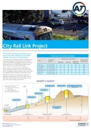
Travelling by car<br />
Due to construction, speeds are restricted to 30km and lanes reduced from three to two<br />
westbound on <strong>the</strong> section <strong>of</strong> Ellerslie-Panmure Highway between <strong>the</strong> roundabout and<br />
Mt Wellington Highway.<br />
From 28 October 2012 until about August 2013 <strong>the</strong>re are major traffic changes to allow<br />
demolition <strong>of</strong> <strong>the</strong> Ellerslie-Panmure Highway (EPH) bridge and construction <strong>of</strong> a new one.<br />
This includes a di<strong>version</strong> and <strong>the</strong> Ellerslie-Panmure Highway eastbound lanes between Forge<br />
Way and Panmure roundabout reduced from two to one.<br />
Heading north to Jellicoe Rd/Glen Innes? Use <strong>the</strong> left lane and follow <strong>the</strong> di<strong>version</strong> via Forge<br />
Way and Mountain Rd bridge<br />
Heading east to Panmure town centre or Pakuranga? Traffic will be reduced to one lane<br />
approaching Panmure roundabout. Please use <strong>the</strong> right hand lane on Ellerslie-Panmure Highway<br />
and continue to come through <strong>the</strong> roundabout.<br />
Buses and trucks for all destinations should also use <strong>the</strong> right lane.<br />
Traffic heading south or west from Glen Innes/Jellicoe Rd, Panmure, Pakuranga and Howick will<br />
continue to come through <strong>the</strong> roundabout and on Ellerslie-Panmure Highway.<br />
Please check signs to ensure you get in <strong>the</strong> correct lane early and be aware traffic will be much<br />
busier at peak times. Consider travelling earlier or later if possible, or using public transport if it<br />
works for your journey.<br />
From late November 2012 until about August 2013 traffic will use a new Ellerslie-Panmure<br />
Highway bridge next to <strong>the</strong> old one. This map shows <strong>the</strong> current routes for traffic through<br />
Panmure.<br />
To help you plan your journey and consider your options, approximate travel times by car to and<br />
through Panmure during <strong>the</strong> am peak are provided below:<br />
To Panmure<br />
Howick village (via Pakuranga) 15 13<br />
Botany Town Centre (via Te Irirangi + Ti Rakau + Lagoon Drive) 25 20<br />
Burswood (via Pakuranga Hwy + Lagoon Drive 15 12<br />
Pakuranga Shopping Centre 6 5<br />
Otahuhu (via Mt Wellington Hwy) 9 9<br />
Ellerslie (Ellerslie -Panmure Highway) 10 12<br />
CBD via Glen Innes 21 28<br />
CBD via Great South Road 27 35<br />
From Panmure<br />
*These am-peak times are approximate and averaged from <strong>Auckland</strong> <strong>Transport</strong> data collection during <strong>the</strong><br />
month <strong>of</strong> June 2012.<br />
8
Traffic routes<br />
Hobson Dr<br />
Pillkington Rd<br />
Morrin Rd<br />
Dunn Rd<br />
Green Rd<br />
Jellicoe Rd<br />
Pleasant <strong>View</strong> Rd<br />
Dunlop Ln<br />
Queens Rd<br />
Lagoon Dr<br />
Construction area<br />
Mt Wellington<br />
Mt Wellington<br />
Domain<br />
Panmure<br />
Mountain Rd<br />
Forge Way<br />
Ireland Rd<br />
to<br />
Glen Innes<br />
Jellicoe Rd<br />
Ellerslie Panmure Hwy<br />
to<br />
Panmure<br />
Howick<br />
Mt Wellington Hwy<br />
to<br />
Glen Innes<br />
Jellicoe Rd<br />
one lane<br />
only east<br />
New bridge<br />
to<br />
Panmure<br />
Howick<br />
Left turn<br />
only<br />
9
Travelling by public transport<br />
Bus and train timetable information is available from <strong>the</strong> AT Public <strong>Transport</strong> website<br />
www.AT.co.nz, it also has a Personal Journey Planner that can help you plan your trip.<br />
It also has <strong>the</strong> most up to date information about any changes that may affect your journey by<br />
public transport in Panmure.<br />
Train<br />
The train service is fully operational and travel times are not affected by construction activities.<br />
O<strong>the</strong>r than some weekends and public holidays when trains aren’t running for rail electrification<br />
work see www.AT.co.nz. However <strong>the</strong> construction work will see changes around <strong>the</strong> station,<br />
passengers should take care on platforms as <strong>the</strong>y will be narrowed in places to allow for construction<br />
work.<br />
Examples <strong>of</strong> average train journey times during <strong>the</strong> morning peak hours are shown below*:<br />
Panmure to<br />
Britomart<br />
Travel time<br />
18 mins<br />
Otahuhu<br />
10 mins<br />
*These times are taken from <strong>the</strong> <strong>Auckland</strong> <strong>Transport</strong><br />
Train Timetable<br />
The frequency <strong>of</strong> Britomart services varies during <strong>the</strong> day with an increased number <strong>of</strong> trains<br />
running between 7-8am when you will have a maximum wait <strong>of</strong> 12 minutes for a train.<br />
Pedestrian access to <strong>the</strong> train station<br />
Pedestrian access to <strong>the</strong> train station changed earlier this year to take account <strong>of</strong> construction<br />
and accommodate <strong>the</strong> opening <strong>of</strong> <strong>the</strong> new pedestrian plaza. This map shows <strong>the</strong>se access points<br />
for pedestrians and for mobility impaired users. All changes to access and routes around <strong>the</strong><br />
station are well sign-posted.<br />
10
Access to Panmure Station<br />
Jellicoe Rd<br />
Queens Rd<br />
Lagoon Dr<br />
Mountain Rd<br />
Potaka Ln<br />
West<br />
Park n Ride<br />
East<br />
Park n Ride<br />
Ireland Rd<br />
Platform 2 Papakura/Manukau<br />
Platform 1 Britomart<br />
Construction area<br />
Footpath closed<br />
Forge Way<br />
Key<br />
Road<br />
Closed<br />
Pedestrian access<br />
New bridge<br />
Pedestrian<br />
crossing<br />
Road<br />
Closed<br />
Station<br />
access<br />
Do Not<br />
Cross<br />
Pedestrian<br />
crossing<br />
Pedestrian<br />
crossing<br />
11
Travelling by bus<br />
The majority <strong>of</strong> buses that travel to and through Panmure leave from stops on Queen’s Road.<br />
These include services connecting Pakuranga, Howick, Botany, Buckland’s Beach and <strong>the</strong> CBD.<br />
These services also stop on <strong>the</strong> Ellerslie Panmure Highway along with buses to Glen Innes.<br />
Bus times to and through Panmure vary by destination. The table below shows approximate<br />
times that buses take to travel from eastern destinations to Panmure during <strong>the</strong> morning peak.<br />
It also shows <strong>the</strong> times <strong>the</strong>y take to travel through Panmure to Britomart in <strong>the</strong> CBD and <strong>the</strong><br />
average frequency.<br />
To Panmure To Britomart Bus Frequency<br />
Howick Village 25 min 1hr 15 min On average every 20 min<br />
Botany Town Centre 25 min 1hr 15 min Every 15 min<br />
Burswood 20 min 1hr 10 min Every 15 min<br />
Pakuranga Town Centre 10 min 1hr On average every 10 min<br />
The AT Public <strong>Transport</strong> Journey Planner can help you plan your trip by public transport.<br />
www.AT.co.nz/journey-planner.<br />
Park and ride<br />
Two park and ride sites provide a useful means <strong>of</strong> accessing <strong>the</strong> train and bus services from<br />
Panmure, but get <strong>the</strong>re early as <strong>the</strong>se are normally full by 7.30am. They are situated to <strong>the</strong> West<br />
(84 spaces) and <strong>the</strong> East (92 spaces) <strong>of</strong> <strong>the</strong> Panmure train station.<br />
12
Public transport information<br />
The AT Public <strong>Transport</strong> website has a range <strong>of</strong> information, including a live departure board,<br />
timetables and transport updates, available at www.AT.co.nz.<br />
The live departure board<br />
Once you have identified your bus stop number through <strong>the</strong> Personal Journey Planner you can<br />
click on it to see a Live Departure Board showing <strong>the</strong> actual times for approaching buses where<br />
<strong>the</strong>se are available.<br />
Where do you want to go in <strong>Auckland</strong>?<br />
From<br />
address or location<br />
To address or location<br />
Time 01 52 PM Date Today<br />
Leave After Arrive Before Customise My Search GO<br />
Information on <strong>the</strong> move<br />
You can also access live departure information on <strong>the</strong> move by downloading <strong>the</strong> AT iPhone or<br />
Android app or by entering your bus stop number at www.AT.co.nz/vpid or texting it to 3666.<br />
online<br />
mobile<br />
web<br />
txt<br />
AT.co.nz<br />
AT.co.nz/vpid<br />
txt<br />
text to 3666<br />
(texts cost 20c incl GST)<br />
Call AT Public <strong>Transport</strong><br />
You can call <strong>the</strong> AT Public <strong>Transport</strong> call centre for help with route, timetable and fare<br />
information on 09 366 6400. The Call Centre is open from 6am - 9pm Monday to Friday, 7am to<br />
8pm Saturday and 8am - 6:30pm Sunday and public holidays.<br />
13
Traffic text alerts: Text AMETI to 244 (first text 20c)<br />
Email newsletter: Sign up at<br />
www.aucklandtransport.govt.nz/ameti<br />
Project information: www.aucklandtransport.govt.nz/ameti<br />
Construction enquiries:<br />
Call Stakeholder Management Specialist Greg Horne on<br />
09 355 3553