Open Space and Recreation Plan - Town of North Andover
Open Space and Recreation Plan - Town of North Andover Open Space and Recreation Plan - Town of North Andover
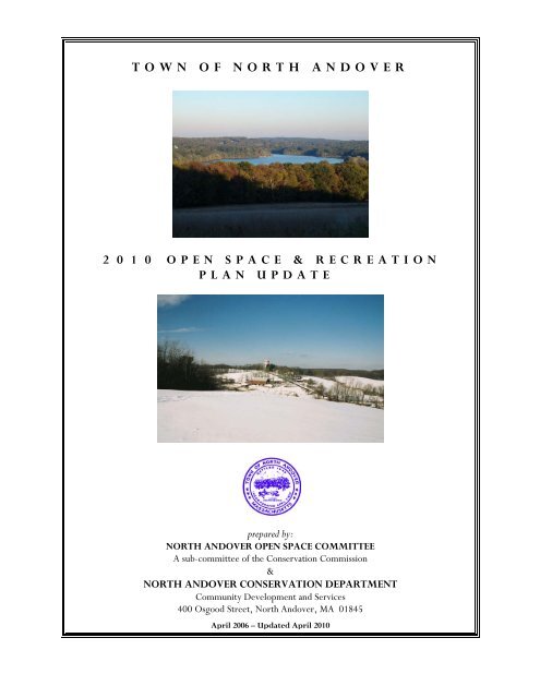
TOWN OF NORTH ANDOVER 2 0 1 0 OPEN SPACE & RECREATION PLAN UPDATE prepared by: NORTH ANDOVER OPEN SPACE COMMITTEE A sub-committee of the Conservation Commission & NORTH ANDOVER CONSERVATION DEPARTMENT Community Development and Services 400 Osgood Street, North Andover, MA 01845 April 2006 – Updated April 2010
- Page 2 and 3: T O W N O F N O R T H A N D O V E R
- Page 4 and 5: T O W N O F N O R T H A N D O V E R
- Page 6 and 7: T O W N O F N O R T H A N D O V E R
- Page 8 and 9: T O W N O F N O R T H A N D O V E R
- Page 10 and 11: T O W N O F N O R T H A N D O V E R
- Page 12 and 13: T O W N O F N O R T H A N D O V E R
- Page 14 and 15: T O W N O F N O R T H A N D O V E R
- Page 16 and 17: T O W N O F N O R T H A N D O V E R
- Page 18 and 19: T O W N O F N O R T H A N D O V E R
- Page 20 and 21: T O W N O F N O R T H A N D O V E R
- Page 22 and 23: T O W N O F N O R T H A N D O V E R
- Page 24 and 25: T O W N O F N O R T H A N D O V E R
- Page 26 and 27: T O W N O F N O R T H A N D O V E R
- Page 28 and 29: T O W N O F N O R T H A N D O V E R
- Page 30 and 31: T O W N O F N O R T H A N D O V E R
- Page 32 and 33: T O W N O F N O R T H A N D O V E R
- Page 34 and 35: T O W N O F N O R T H A N D O V E R
- Page 36 and 37: T O W N O F N O R T H A N D O V E R
- Page 38 and 39: T O W N O F N O R T H A N D O V E R
- Page 40 and 41: T O W N O F N O R T H A N D O V E R
- Page 42 and 43: T O W N O F N O R T H A N D O V E R
- Page 44 and 45: T O W N O F N O R T H A N D O V E R
- Page 46 and 47: T O W N O F N O R T H A N D O V E R
- Page 48 and 49: T O W N O F N O R T H A N D O V E R
- Page 50 and 51: T O W N O F N O R T H A N D O V E R
TOWN OF NORTH ANDOVER<br />
2 0 1 0 OPEN SPACE & RECREATION<br />
PLAN UPDATE<br />
prepared by:<br />
NORTH ANDOVER OPEN SPACE COMMITTEE<br />
A sub-committee <strong>of</strong> the Conservation Commission<br />
&<br />
NORTH ANDOVER CONSERVATION DEPARTMENT<br />
Community Development <strong>and</strong> Services<br />
400 Osgood Street, <strong>North</strong> <strong>Andover</strong>, MA 01845<br />
April 2006 – Updated April 2010
T O W N O F N O R T H A N D O V E R<br />
O P E N S P A C E A N D R E C R E A T I O N P L A N 2 0 0 6<br />
2 0 1 0 U P D A T E<br />
The <strong>Open</strong> <strong>Space</strong> Committee was created in 1996 as a result <strong>of</strong> the 1995 <strong>Open</strong> <strong>Space</strong> <strong>and</strong><br />
<strong>Recreation</strong> <strong>Plan</strong>. Members <strong>of</strong> the <strong>Open</strong> <strong>Space</strong> Committee <strong>and</strong> Conservation Department<br />
include:<br />
Scott Masse<br />
Al Manzi, Jr.<br />
Deb Feltovic<br />
Joe Lynch<br />
Jack Mabon<br />
Sean McDonough<br />
Lou Napoli<br />
Jennifer Hughes, Conservation Administrator<br />
Heidi Gaffney, Conservation Associate<br />
Donna Wedge, Conservation Departmental Assistant<br />
Cover Photograph (top): View <strong>of</strong> Lake Cochichewick from Half Mile Hill Summit.<br />
Picture taken by Pamela A. Merrill<br />
Cover Photograph (bottom): View <strong>of</strong> Barker’s Farm from the Carter Hill Vista.<br />
Picture taken by David J. Solomon<br />
2
T O W N O F N O R T H A N D O V E R<br />
O P E N S P A C E A N D R E C R E A T I O N P L A N 2 0 0 6<br />
2 0 1 0 U P D A T E<br />
T A B L E O F C O N T E N T S<br />
Section 1: PLAN SUMMARY. . . . 4<br />
Section 2: INTRODUCTION. . . . 6<br />
2.1 Statement <strong>of</strong> Purpose<br />
2.2 <strong>Plan</strong>ning Process <strong>and</strong> Public Participation<br />
Section 3: COMMUNITY SETTING . . . . 8<br />
3.1 Regional Context<br />
3.2 Community History<br />
3.3 Population Characteristics<br />
3.4 Growth <strong>and</strong> Development Patterns<br />
Page<br />
Section 4: NATURAL RESOURCE INVENTORY AND ANALYSIS. . 22<br />
4.1 Geology<br />
Surficial Geology, Bedrock Geology, Soils<br />
4.2 L<strong>and</strong>scape Character<br />
Hilltops, Farml<strong>and</strong><br />
4.3 Water Resources<br />
Surface Waters, Wetl<strong>and</strong>s, Flood Hazard Areas<br />
4.4 Vegetation<br />
Non-Forested Resources, Forested Resources<br />
4.5 Fisheries <strong>and</strong> Wildlife<br />
Fisheries, Wildlife, Rare, <strong>North</strong> American Beavers, Threatened <strong>and</strong> Endangered Species<br />
4.6 Scenic Resources <strong>and</strong> Unique Environments<br />
Historic L<strong>and</strong>scapes, Prehistoric Resources, Historic Resources<br />
4.7 Environmental Problems<br />
Hazardous Waste, Air Quality, Development Impact<br />
Section 5: INVENTORY OF CONSERVATION AND RECREATION LAND. 39<br />
5.1 Protected <strong>Open</strong> <strong>Space</strong><br />
Public Protected <strong>Open</strong> <strong>Space</strong>, Private Protected <strong>Open</strong> <strong>Space</strong>, Conservation Restrictions,<br />
5.2 <strong>Plan</strong>ned Residential Development (PRDs)<br />
5.3 Unprotected L<strong>and</strong> <strong>of</strong> Conservation Interest<br />
5.4 Public <strong>Recreation</strong> Areas<br />
Parks <strong>and</strong> Playgrounds, Stewardship Program, Hiking Trails<br />
5.5 Private <strong>Recreation</strong> Areas<br />
5.6 Chapter 61, 61A, 61B<br />
5.7 Agricultural Preservation Restriction Program (APR)<br />
5.8 Master Table<br />
3
T O W N O F N O R T H A N D O V E R<br />
O P E N S P A C E A N D R E C R E A T I O N P L A N 2 0 0 6<br />
2 0 1 0 U P D A T E<br />
Section 6: COMMUNITY GOALS . . . . 59<br />
6.1 Description <strong>of</strong> Process<br />
6.2 Statement <strong>of</strong> <strong>Open</strong> <strong>Space</strong> <strong>and</strong> <strong>Recreation</strong> Goals<br />
Section 7: NEEDS ASSESSMENT . . . . 62<br />
7.1 Resource Protection Needs<br />
Lake Cochichewick Watershed Protection, Protection <strong>of</strong> <strong>Open</strong> <strong>Space</strong> <strong>and</strong> Rural<br />
Character, Limiting Growth<br />
7.2 Community Needs<br />
7.3 Management Needs<br />
Section 8: GOALS AND OBJECTIVES. . . . 68<br />
Section 9: SEVEN-YEAR ACTION PLAN . . 75<br />
Section 10: Public Comment. . . . 83<br />
Section 11: REFERENCES. . . . 84<br />
Page<br />
LIST OF APPENDICIES<br />
Appendix A: BIRDS OF MAZURENKO FARM CONSERVATION AREA. 89<br />
Appendix B: SOIL ASSOCIATION. . . . 91<br />
Appendix C: BEDROCK GEOLOGY. . . . 92<br />
Appendix D: MAPS. . . . . 93<br />
Zoning Map<br />
Current L<strong>and</strong> Use Map<br />
Action <strong>Plan</strong> Map<br />
<strong>Open</strong> <strong>Space</strong> Map<br />
Estimated Habitat For Endangered Species<br />
Soils Map<br />
Historical Maps (1884)<br />
Appendix E: <strong>Open</strong> <strong>Space</strong> <strong>Plan</strong> Survey . . . 101<br />
Appendix F: ADA Accessibility Report . . . 116<br />
Appendix G: <strong>Town</strong> Owned <strong>Open</strong> <strong>Space</strong> Matrix . . 133<br />
4
T O W N O F N O R T H A N D O V E R<br />
O P E N S P A C E A N D R E C R E A T I O N P L A N 2 0 0 6<br />
1.0 PLAN SUMMARY<br />
2 0 1 0 U P D A T E<br />
The 2006 <strong>North</strong> <strong>Andover</strong> <strong>Open</strong> <strong>Space</strong> <strong>and</strong> <strong>Recreation</strong> <strong>Plan</strong> <strong>and</strong> its 2010 update are essential updates <strong>of</strong> the<br />
comprehensive 2000 <strong>Plan</strong>, which assembled comprehensive input from the 1998 Master <strong>Plan</strong> efforts. In<br />
addition, the 2006 <strong>and</strong> 2010 <strong>Plan</strong>a provides updated inventories <strong>of</strong> <strong>North</strong> <strong>Andover</strong>'s Community Setting,<br />
Environmental features, <strong>and</strong> L<strong>and</strong>s <strong>of</strong> Conservation <strong>and</strong> <strong>Recreation</strong> interest. The <strong>Plan</strong> culminates in a series <strong>of</strong><br />
sixteen (16) updated recommendations from the 2000 <strong>Plan</strong>, supporting:<br />
<br />
<br />
<br />
Sustained Watershed Protection;<br />
Preservation <strong>of</strong> the <strong>Town</strong>'s <strong>Open</strong> <strong>and</strong> Rural character;<br />
And increasing <strong>Recreation</strong>al opportunities <strong>and</strong> quality <strong>of</strong> life in <strong>North</strong> <strong>Andover</strong>.<br />
The full set <strong>of</strong> recommendations appearing in Section 9 are set forth in an updated Seven Year Action <strong>Plan</strong> in<br />
Section 9, according to their importance within the Community <strong>and</strong> their impact on resource conservation.<br />
5
T O W N O F N O R T H A N D O V E R<br />
O P E N S P A C E A N D R E C R E A T I O N P L A N 2 0 0 6<br />
2.0 INTRODUCTION<br />
2.1 STATEMENT OF PURPOSE<br />
2 0 1 0 U P D A T E<br />
The purpose <strong>of</strong> this 2006 <strong>North</strong> <strong>Andover</strong> <strong>Open</strong> <strong>Space</strong> <strong>and</strong> <strong>Recreation</strong> <strong>Plan</strong> is to show where we were,<br />
where we are, <strong>and</strong> where we wish to go in regard to open space <strong>and</strong> recreation in the <strong>Town</strong> <strong>of</strong> <strong>North</strong><br />
<strong>Andover</strong>, Massachusetts. A look at the open space map for the <strong>Town</strong> <strong>of</strong> <strong>North</strong> <strong>Andover</strong> indicates the great<br />
work that has been accomplished by a <strong>Town</strong> that truly cares about its open space <strong>and</strong> image. Critical parcels<br />
<strong>of</strong> l<strong>and</strong> have been acquired for preservation throughout the <strong>Town</strong>, <strong>and</strong> in a significant act <strong>of</strong> <strong>Open</strong> <strong>Space</strong><br />
support, <strong>North</strong> <strong>Andover</strong> was one <strong>of</strong> the first communities in Massachusetts to adopt the Community<br />
Preservation Act at the maximum funding level. Much has been accomplished in the short tenure <strong>of</strong> the<br />
Community Preservation Committee in the form <strong>of</strong> <strong>Open</strong> <strong>Space</strong> acquisitions <strong>and</strong> Watershed protection. It<br />
is no overstatement to assert that Community Preservation Act funding has been the single most significant<br />
contributor to the achievement <strong>of</strong> the 2000 <strong>Open</strong> <strong>Space</strong> <strong>and</strong> <strong>Recreation</strong> <strong>Plan</strong> goals. The <strong>Town</strong> has made<br />
significant progress in <strong>Town</strong>-owned facilities by constructing a new High School in 2004, <strong>and</strong> a new Youth<br />
Center in 2001. Since the inception <strong>of</strong> the original <strong>Open</strong> <strong>Space</strong> <strong>and</strong> <strong>Recreation</strong> <strong>Plan</strong> in 1970, the<br />
community has developed a number <strong>of</strong> similar planning documents, which have also articulated the need to<br />
protect open space <strong>and</strong> provide recreational opportunities for this growing community. These documents<br />
include:<br />
The <strong>North</strong> <strong>Andover</strong> Comprehensive <strong>Plan</strong> 1972<br />
The <strong>Open</strong> <strong>Space</strong> <strong>and</strong> <strong>Recreation</strong> <strong>Plan</strong> 1980, 1987, 1995, 2000<br />
The Phased Development Bylaw 1986<br />
The Balanced Growth <strong>Plan</strong> 1987<br />
The Lake Cochichewick Watershed <strong>Plan</strong> 1987<br />
The ENSR Report on Lake Cochichewick 1987<br />
The Growth Management Bylaw 1996<br />
The Three Interim Master <strong>Plan</strong> Reports 1997, 1998, 1999<br />
The <strong>North</strong> <strong>Andover</strong> Wetl<strong>and</strong>s Protection Bylaw <strong>and</strong> Regulations 1998 REV 9-10-03<br />
The Lake Cochichewick Watershed <strong>Plan</strong> 1999<br />
The ENSR Report on Lake Cochichewick 1999<br />
The <strong>Open</strong> <strong>Space</strong> <strong>and</strong> <strong>Recreation</strong> <strong>Plan</strong> 2000<br />
Essex County <strong>Open</strong> <strong>Space</strong> Reconnaissance Project 2005<br />
The <strong>North</strong> <strong>Andover</strong> Zoning Bylaw 1972 REV 5-2005<br />
6
T O W N O F N O R T H A N D O V E R<br />
O P E N S P A C E A N D R E C R E A T I O N P L A N 2 0 0 6<br />
2 0 1 0 U P D A T E<br />
The <strong>North</strong> <strong>Andover</strong> <strong>Open</strong> <strong>Space</strong> Committee has changed structure <strong>and</strong> appearance significantly since the<br />
2000 <strong>Open</strong> <strong>Space</strong> <strong>and</strong> <strong>Recreation</strong> <strong>Plan</strong>, with adoption <strong>of</strong> the Community Preservation Act in 2001. <strong>North</strong><br />
<strong>Andover</strong> was one <strong>of</strong> the first communities in Massachusetts to institute this Preservation Act. The funds<br />
come from a 3% property surcharge <strong>and</strong> have been matched 100% by the Commonwealth every year. The<br />
<strong>Open</strong> <strong>Space</strong> Committee <strong>and</strong> Conservation Department have continued its progress with developing more<br />
accurate <strong>and</strong> comprehensive open space mapping, <strong>and</strong> has used Community Preservation funds, in<br />
cooperation with the Community Preservation Committee to achieve the goals <strong>of</strong> primary importance in<br />
the areas <strong>of</strong> open space acquisition, watershed protection, historic preservation <strong>and</strong> recreation.<br />
The acquisition <strong>of</strong> significant open space parcels by the Community Preservation Committee since 2000 has<br />
further heightened the need for continued progress in the improvement <strong>of</strong> information, mapping resources<br />
<strong>and</strong> records <strong>of</strong> the new <strong>and</strong> existing <strong>Town</strong>-owned properties. Needs identified in 2000 as:<br />
<br />
<br />
<br />
<br />
<br />
Accurate <strong>Open</strong> <strong>Space</strong> maps<br />
Additional trail maps<br />
Acquisition <strong>of</strong> targeted <strong>Open</strong> <strong>Space</strong> sites<br />
Creation <strong>of</strong> <strong>Open</strong> <strong>Space</strong> interconnections<br />
Community paths <strong>and</strong> village ways<br />
have become a larger task with the advent <strong>of</strong> additional <strong>Open</strong> <strong>Space</strong> purchases. Consequently, the need for<br />
well designed Management <strong>Plan</strong>s <strong>and</strong> execution <strong>of</strong> those plans by the <strong>Town</strong> Departments <strong>and</strong> volunteer<br />
organizations is the logical next step to the l<strong>and</strong> acquisition process. As steward <strong>of</strong> the <strong>Town</strong>-owned <strong>Open</strong><br />
<strong>Space</strong>s, the Conservation Department <strong>and</strong> Commission have taken the lead in developing a revised concept<br />
<strong>of</strong> <strong>Open</strong> <strong>Space</strong> Management, <strong>and</strong> related organizational <strong>and</strong> resource needs. The Community Preservation<br />
Committee is once again a key partnership in cooperative achievement <strong>of</strong> the <strong>Town</strong>’s <strong>Open</strong> <strong>Space</strong><br />
Management goals.<br />
2.2 PLANNING PROCESS AND PUBLIC PARTICIPATION<br />
As open space <strong>and</strong> preservation issues fall under the jurisdiction <strong>of</strong> the Conservation Department, the<br />
Conservation Commission has reviewed the 2000 <strong>Open</strong> <strong>Space</strong> <strong>and</strong> <strong>Recreation</strong> <strong>Plan</strong> <strong>and</strong> completed minor<br />
updates, keeping in place the primary emphasis <strong>of</strong> the 2000 plan. The updated draft plan was reviewed with<br />
all l<strong>and</strong> use boards <strong>and</strong> other related organizations in town, as an opportunity to provide comments, input<br />
<strong>and</strong> contributions to the revised plan.<br />
As overseer <strong>of</strong> the <strong>Town</strong>-owned open spaces, the Conservation Commission has adopted the task <strong>of</strong><br />
updating the 2000 <strong>Open</strong> <strong>Space</strong> & <strong>Recreation</strong> <strong>Plan</strong>. As there were no significant efforts to re-define town<br />
goals <strong>and</strong> preferences, such as the 1998 Master <strong>Plan</strong>, the Community Development Director <strong>and</strong> the<br />
Conservation Department agreed on the approach <strong>of</strong> updating the comprehensive 2000 <strong>Open</strong> <strong>Space</strong> &<br />
<strong>Recreation</strong> plan in July 2005, focusing on updating the focus <strong>of</strong> the goals, in light <strong>of</strong> the past five years<br />
progress. In October 2005, the Conservation Department met with the Community Preservation<br />
Committee to present the concept <strong>of</strong> updating <strong>and</strong> creating <strong>Open</strong> <strong>Space</strong> Management <strong>Plan</strong>s for <strong>Town</strong>owned<br />
l<strong>and</strong> managed by the Conservation Commission. A request for funds will be forthcoming to support<br />
<strong>Open</strong> <strong>Space</strong> Management in alignment with the management concept <strong>and</strong> this plan.<br />
7
T O W N O F N O R T H A N D O V E R<br />
O P E N S P A C E A N D R E C R E A T I O N P L A N 2 0 0 6<br />
3.0 COMMUNITY SETTING<br />
2 0 1 0 U P D A T E<br />
This section discusses how <strong>North</strong> <strong>Andover</strong> evolved. The history <strong>of</strong> the <strong>Town</strong>'s settlement, growth <strong>and</strong><br />
development will be presented. While each community is unique, growth <strong>and</strong> development occurs as a result<br />
<strong>of</strong> interactions with other communities. The regional factors that have had an effect on the community’s<br />
development are also presented. These factors may determine the future challenges that <strong>North</strong> <strong>Andover</strong> will<br />
face.<br />
3.1 REGIONAL CONTEXT<br />
The <strong>Town</strong> <strong>of</strong> <strong>North</strong> <strong>Andover</strong> lies along the banks <strong>of</strong> the Merrimack River in the Merrimack Valley in the<br />
northeast corner <strong>of</strong> Massachusetts. The historical map found in Appendix D shows the Merrimack River as the<br />
community's most prominent natural feature. The river has undoubtedly driven the growth <strong>and</strong> development<br />
<strong>of</strong> most <strong>of</strong> the communities in the Merrimack Valley. In the late 18th century <strong>and</strong> throughout the 19th century,<br />
mills sprouted up along the river <strong>and</strong> its countless tributaries. The smaller tributaries were less prone to<br />
devastating floods <strong>and</strong> were very valuable mill sites. Two <strong>of</strong> those tributaries, the Shawsheen River <strong>and</strong><br />
Cochichewick Brook were located within the original <strong>Andover</strong> settlement. These waterways saw intense mill<br />
development, particularly in the 19th century, which transformed the community from an agricultural village<br />
to a more diverse one <strong>of</strong> mills <strong>and</strong> farml<strong>and</strong>.<br />
<strong>North</strong> <strong>Andover</strong> is a highl<strong>and</strong> on the outer edge <strong>of</strong> the Merrimack Valley. The prominent hills drain into<br />
numerous wetl<strong>and</strong>s. These wetl<strong>and</strong>s are the headwaters <strong>of</strong> three separate rivers: the Ipswich River, the Parker<br />
River <strong>and</strong> Cochichewick Brook. The Ipswich River flows twenty miles to the sea through Boxford, Middleton,<br />
Topsfield, Hamilton, <strong>and</strong> Ipswich. One emergency well <strong>and</strong> one weekend well are located along the Ipswich<br />
River in Ipswich. The Parker River flows through Boxford, Georgetown, <strong>and</strong> Newbury twenty miles to the<br />
sea. Along the way, this river supplies water to underground aquifers, which sustain four public wells in<br />
Georgetown. Countless private wells are also served by underground aquifers in the Parker <strong>and</strong> Ipswich River<br />
watersheds. The <strong>Town</strong> <strong>of</strong> <strong>North</strong> <strong>Andover</strong> has recognized the importance <strong>of</strong> the Ipswich River relative to the<br />
water supplies by requiring the same minimum lot size in much <strong>of</strong> the Ipswich River watershed as in the Lake<br />
Cochichewick Watershed District.<br />
Cochichewick Brook flows from Lake Cochichewick, which is the sole source <strong>of</strong> public drinking water for the<br />
people <strong>of</strong> <strong>North</strong> <strong>Andover</strong>. Lake Cochichewick watershed is approximately 2,732 acres in size, 378 acres (14%)<br />
<strong>of</strong> which lies within the <strong>Town</strong> <strong>of</strong> Boxford. This part <strong>of</strong> Boxford is zoned residential <strong>and</strong> is sparsely developed.<br />
The <strong>Town</strong> <strong>of</strong> <strong>North</strong> <strong>Andover</strong> must continue to keep a watchful eye on the future development <strong>of</strong> this portion<br />
<strong>of</strong> the watershed since the <strong>Town</strong> has little control over it. Experience has shown that controlling growth has<br />
been very difficult in the portion <strong>of</strong> the watershed that lies within <strong>North</strong> <strong>Andover</strong>; controlling growth in another<br />
community will present even more challenges.<br />
Today, regional transportation routes have a major impact on <strong>North</strong> <strong>Andover</strong>'s character. Secondary highways<br />
such as Routes 114, 125 <strong>and</strong> 133 have been important in providing local <strong>and</strong> regional transportation routes.<br />
Route 114 brought goods to <strong>and</strong> from the bustling port <strong>of</strong> Salem. Route 125 was the direct route to the<br />
prosperous mill town <strong>of</strong> Haverhill, while Route 133 was the major route to the mill centers <strong>of</strong> <strong>Andover</strong> <strong>and</strong><br />
Lowell. When they were first laid out, these early roads were the only dependable routes to the regional<br />
8
T O W N O F N O R T H A N D O V E R<br />
O P E N S P A C E A N D R E C R E A T I O N P L A N 2 0 0 6<br />
2 0 1 0 U P D A T E<br />
centers <strong>of</strong> commerce. Such roadways made it possible to transport raw materials to, <strong>and</strong> finished goods from<br />
the local mills.<br />
These roads are now secondary highways that funnel traffic to the two major interstate highways, Routes 93<br />
<strong>and</strong> 495. These highways have had perhaps the greatest impact on the community's growth <strong>and</strong> development in<br />
the latter half <strong>of</strong> this century. Route 93 makes <strong>North</strong> <strong>Andover</strong> accessible for those who work in Metropolitan<br />
Boston, while Route 495 provides quick access to the job markets, which have filled the void left by the failure<br />
<strong>of</strong> the mills throughout the Merrimack Valley.<br />
3.2 COMMUNITY HISTORY<br />
The original settlement <strong>of</strong> <strong>Andover</strong> was located in the area bounded by <strong>Andover</strong>, Osgood <strong>and</strong> Court Streets<br />
<strong>and</strong> Academy Road. It was based on the jointly held field system <strong>of</strong> the part <strong>of</strong> Engl<strong>and</strong> most <strong>of</strong> the founders<br />
came from. The small cluster <strong>of</strong> house lots was surrounded by l<strong>and</strong> used for planting, woods <strong>and</strong> swamps.<br />
By the end <strong>of</strong> the 17 th century, the common field system had devolved into individual holdings. Settlement<br />
had spread into the southern part <strong>of</strong> town that would eventually become the “South Parish” <strong>and</strong> even later,<br />
in 1855, become “<strong>Andover</strong>”, taking the name <strong>of</strong> the original settlement.<br />
In the early 1690s, <strong>Andover</strong> was caught up in the witchcraft hysteria <strong>of</strong> Essex County when dozens <strong>of</strong><br />
residents were imprisoned <strong>and</strong> three hanged. <strong>Andover</strong> men were involved in the several French <strong>and</strong> Indian<br />
Wars, taking part in raids up into Canada. <strong>Andover</strong> was active in the Revolutionary War, sending<br />
minutemen to Concord <strong>and</strong> publishing the full text <strong>of</strong> the Declaration <strong>of</strong> Independence in the <strong>Town</strong><br />
Meeting report.<br />
In the early 19 th century, the <strong>North</strong> Parish was still primarily agricultural, although a thriving, but short-<br />
built in 1802 on the Cochichewick near the Merrimack <strong>and</strong> still exists today. Other mills were built along<br />
lived shoe industry grew up around the crossroads village in what is now the old center. A carding mill was<br />
the brook, which at one time supported 4 major mills connected with textile manufacture. The outlet <strong>of</strong><br />
Cochichewick Brook to the Lake Cochichewick was dammed to regulate the flow <strong>of</strong> waterpower to the<br />
mills, which in turn, would increase the size <strong>of</strong> the lake several times. The original millponds still exists,<br />
hidden behind mill <strong>and</strong> business buildings, <strong>and</strong> residential condominiums. This <strong>of</strong>fers a possible scenic<br />
pathway connecting the Merrimack River with Lake Cochichewick.<br />
The founding <strong>of</strong> the City <strong>of</strong> Lawrence was the catalyst, which led to the division <strong>of</strong> the <strong>Town</strong> into three (3)<br />
segments before the Civil War. In the <strong>North</strong> Parish, now <strong>North</strong> <strong>Andover</strong>, the mills along Cochichewick<br />
Brook grew, <strong>and</strong> a new commercial center developed closer to the Merrimack River <strong>and</strong> to Lawrence.<br />
“Machine Shop Village” is a National Register District in the downtown area that contains examples <strong>of</strong> the<br />
former textile industry buildings, as well as factory-built workers housing, stores, a church <strong>and</strong> an owner’s<br />
residence.<br />
The old center village escaped pressure for development <strong>and</strong> largely retains its 19 th century appearance<br />
today. Several <strong>of</strong> the structures around the Common are owned or protected by the <strong>North</strong> <strong>Andover</strong><br />
Historical Society. The Common itself, created in the 19 th century by the <strong>North</strong> <strong>Andover</strong> Improvement<br />
Society was turned over to the <strong>Town</strong> in the 1950s after the last house had been removed. It serves as a<br />
location for <strong>Town</strong> celebrations <strong>and</strong> for a variety <strong>of</strong> passive recreation uses. It is also the focus <strong>of</strong> the <strong>Town</strong>’s<br />
9
T O W N O F N O R T H A N D O V E R<br />
O P E N S P A C E A N D R E C R E A T I O N P L A N 2 0 0 6<br />
2 0 1 0 U P D A T E<br />
only local historic district. <strong>North</strong> <strong>Andover</strong> residents appreciate the historic character <strong>of</strong> their community,<br />
which still retains many examples <strong>of</strong> buildings <strong>and</strong> l<strong>and</strong>scapes from former days.<br />
Population continued to rise during the 20 th Century, although the shift <strong>of</strong> textile manufacturing to the<br />
South after WWII meant the loss <strong>of</strong> factory jobs. Some <strong>of</strong> these jobs were replaced with new industry such<br />
as the large Western Electric (now Lucent Technologies) plant. Until the 1960s, however the eastern <strong>and</strong><br />
southern sections <strong>of</strong> town were still largely undeveloped open space.<br />
3.3 POPULATION CHARACTERISTICS<br />
The population <strong>of</strong> <strong>North</strong> <strong>Andover</strong> has grown steadily throughout the 20 th century. Table 3.31 demonstrates<br />
this growth over the past 100 years.<br />
T able 3.3.1<br />
As immigrants came to work in the woolen mills, they tended to settle within walking distance <strong>of</strong> those<br />
mills. This led to a concentration <strong>of</strong> factory housing, modest homes <strong>and</strong> a few owners’ mansions in a<br />
relatively dense settlement in the northwest part <strong>of</strong> <strong>Town</strong> along Cochichewick Brook. Many <strong>of</strong> the <strong>Town</strong>’s<br />
recreational areas are located in these older neighborhoods, <strong>and</strong> are heavily used.<br />
Up until the last quarter <strong>of</strong> the century, the rest <strong>of</strong> the <strong>Town</strong> was mainly undeveloped, with a number <strong>of</strong><br />
farms <strong>and</strong> few large country estates bordering Lake Cochichewick, built by wealthy mill owners. From<br />
1950 to 1970, the population almost doubled. During this period, Routes 93 <strong>and</strong> 495 were completed,<br />
10
T O W N O F N O R T H A N D O V E R<br />
O P E N S P A C E A N D R E C R E A T I O N P L A N 2 0 0 6<br />
2 0 1 0 U P D A T E<br />
putting <strong>North</strong> <strong>Andover</strong> within driving distance <strong>of</strong> employment in the Metropolitan Boston region;<br />
therefore, making the <strong>Town</strong> attractive as a residence for commuters. Rapid growth has continued<br />
throughout the 21 st century.<br />
<strong>North</strong> <strong>Andover</strong>’s population has grown to 29,549 as estimated by the <strong>Town</strong> Clerk’s <strong>of</strong>fice in November<br />
2005. This population increase has led to a corresponding decrease in open space, even though the<br />
perception <strong>of</strong> <strong>North</strong> <strong>Andover</strong> as a town with a great deal <strong>of</strong> open space is one <strong>of</strong> the reasons given for<br />
moving here. Past surveys indicate that many residents thought that these open spaces were somehow<br />
protected <strong>and</strong> would remain open.<br />
In conjunction with the overall population growth has come a growth in the senior <strong>and</strong> teenage populations<br />
with their separate recreational needs. The Senior Center that flanks to <strong>Town</strong> Hall was built in 1984 <strong>and</strong><br />
exp<strong>and</strong>ed in 1997. Construction <strong>of</strong> a new Youth Center in the Old <strong>Town</strong> Center was completed in the<br />
summer <strong>of</strong> 2000, <strong>and</strong> a new High School complex was recently completed in 2004 - 05.<br />
Changes in employment trends in Massachusetts can be seen in Table 3.32.<br />
Table 3.32 Employment Trends<br />
Area <strong>of</strong> Employment<br />
Percent in the<br />
Workforce in 1989<br />
Percent in the Percent in the<br />
Workforce in 1998<br />
Workforce in 2000<br />
Manufacturing 54.0 42.0 17.2<br />
Services 15.5 29.0 10.3<br />
Trade 11.0 13.0 9.9<br />
Government 4.2 4.7 11.5<br />
Transportation, Communications,<br />
Public Utilities<br />
7.0 4.2 2.9<br />
Construction 2.7 3.0 3.9<br />
Finance, Insurance, Real Estate 3.6 2.6 10.0<br />
Agriculture, Fisheries, Forestry 0.08 1.3 0.7<br />
Pr<strong>of</strong>essional, Scientific,<br />
Administrative, Management - - 66.3<br />
(Source: Commonwealth <strong>of</strong> Massachusetts, Division <strong>of</strong> Employment <strong>and</strong> Training (ES-202 Series))<br />
*Pr<strong>of</strong>essional, Scientific, Administrative, Management was not previously included.<br />
As with many towns in the state <strong>of</strong> Massachusetts, <strong>North</strong> <strong>Andover</strong> has seen a shift away from manufacturing<br />
jobs <strong>and</strong> toward high tech, service employment. Much <strong>of</strong> the recent population growth has changed <strong>North</strong><br />
<strong>Andover</strong> from a blue collar to a white-collar community. This may increase interest in open space<br />
protection <strong>and</strong> conservation issues. There has been an increased dem<strong>and</strong> for recreational facilities,<br />
particularly playing fields for rapidly growing sports programs, such as soccer <strong>and</strong> baseball. In previous<br />
<strong>Open</strong> <strong>Space</strong> <strong>Plan</strong>s, it was clear that the <strong>Town</strong> was not meeting the community’s recreational needs.<br />
However, within the last five (5) years several recreational fields have been constructed to fulfill this<br />
necessity, including the Carter Farm Soccer Fields (3), Foster Farm Soccer Fields (2), <strong>and</strong> an entire new<br />
track <strong>and</strong> field, as well as soccer, football, baseball <strong>and</strong> s<strong>of</strong>tball fields at the new high school.<br />
11
T O W N O F N O R T H A N D O V E R<br />
O P E N S P A C E A N D R E C R E A T I O N P L A N 2 0 0 6<br />
2 0 1 0 U P D A T E<br />
When the <strong>Plan</strong>ning Board adopted <strong>North</strong> <strong>Andover</strong>’s first master plan (1957), manufacturing jobs comprised<br />
more than 95% <strong>of</strong> the town’s total employment. A “company town” making the transition from textiles to<br />
technology, <strong>North</strong> <strong>Andover</strong> had recently attracted a new Western Electric Company manufacturing plant<br />
on Osgood Street near Haverhill. 7 Although <strong>North</strong> <strong>Andover</strong> aspired to be one <strong>of</strong> the region’s top industrial<br />
centers, manufacturing employment paralleled regional trends <strong>and</strong> gave way to growth in other industries.<br />
During the 1990s, manufacturing employment declined by nearly 50% in <strong>North</strong> <strong>Andover</strong>. Manufacturing<br />
still exceeds other industries for total employment, but service jobs have become an increasingly prominent<br />
part <strong>of</strong> the town’s economy. In 1990, <strong>North</strong> <strong>Andover</strong> had 3.55 manufacturing jobs for every service job; by<br />
2001, the ratio had dropped to 1.43. 8 Similar rates <strong>of</strong> decline have occurred throughout <strong>North</strong> <strong>Andover</strong>’s<br />
region, yet some communities with a much smaller manufacturing base absorbed modest growth in<br />
manufacturing employment toward the end <strong>of</strong> the decade.<br />
<strong>North</strong> <strong>Andover</strong>’s overall population growth included the senior <strong>and</strong> teenage populations with their separate<br />
recreational needs. The Senior Center that flanks <strong>Town</strong> Hall was built in 1984 <strong>and</strong> exp<strong>and</strong>ed in 1997. The<br />
townspeople also constructed a new Youth Center, with primarily private funding, in the Old <strong>Town</strong> Center<br />
in the summer <strong>of</strong> 2000, along with a new High School complex in 2005.<br />
Household Income<br />
<strong>North</strong> <strong>Andover</strong>’s median household income <strong>of</strong> $72,728 ranks 60 th in the Commonwealth <strong>and</strong> is about 1.35<br />
times higher than the median for the Lawrence metropolitan area. While one-third <strong>of</strong> the town’s<br />
households have annual incomes below the Lawrence area median, 8.7% have annual incomes <strong>of</strong> $ 200,000<br />
or more – a rate that in <strong>North</strong> <strong>Andover</strong>’s region is surpassed only by <strong>Andover</strong>, Boxford <strong>and</strong> Topsfield.<br />
Heads <strong>of</strong> households between 45 – 54 years <strong>of</strong> age represented <strong>North</strong> <strong>Andover</strong>’s highest income age group,<br />
with its lowest income households in the very young – people under 24; <strong>and</strong> elderly households headed by<br />
persons over 75. Household type is also important influencing total household income. Families in <strong>North</strong><br />
<strong>Andover</strong> generally have higher incomes than non-family households <strong>and</strong> this applies to <strong>North</strong> <strong>Andover</strong> as<br />
well, but the difference is somewhat more pronounced. <strong>North</strong> <strong>Andover</strong>’s median family income <strong>of</strong><br />
$92,450 is 1.41 times higher than the median household income for the state, a ratio that slightly exceeds<br />
that <strong>of</strong> nearby communities. In addition, non-family households (one-person households <strong>and</strong> households <strong>of</strong><br />
unrelated individuals) usually have somewhat lower incomes in relation to the household median. Again,<br />
<strong>North</strong> <strong>Andover</strong> experience is fairly typical: its median no-family household income is $30,994.<br />
Approximately 2.9% <strong>of</strong> the town’s population falls below the federal poverty st<strong>and</strong>ard. Among persons<br />
below poverty, 82% are below age 65 <strong>and</strong> 63% are in family households.<br />
3.4 GROWTH AND DEVELOPMENT PATTERNS<br />
<strong>North</strong> <strong>Andover</strong> first adopted local zoning in 1943. The current zoning map is included on the following<br />
page. The <strong>North</strong> <strong>Andover</strong> Zoning Bylaw has been revised <strong>and</strong> updated on numerous occasions, most<br />
recently in May 2004. It includes <strong>Plan</strong>ned Residential Development (PRDs) (a.k.a., Cluster Zoning),<br />
Watershed Protection District, Floodplain District, Phased Development Bylaw <strong>and</strong> Site <strong>Plan</strong> Review.<br />
There are seven (7) residential zones including R6 <strong>and</strong> Village Residential. The R6 zone allows six (6) lots<br />
per acre <strong>and</strong> Village Residential zone allows four (4) homes per acre (with sewer). This Village Residential<br />
12
T O W N O F N O R T H A N D O V E R<br />
O P E N S P A C E A N D R E C R E A T I O N P L A N 2 0 0 6<br />
2 0 1 0 U P D A T E<br />
zone has recently been changed back to one (1) home per acre, but there is a significant development gr<strong>and</strong>fathered<br />
under the four (4) homes per acre allowance. To date, there is no remaining l<strong>and</strong> available for<br />
development in the R6 zone.<br />
<strong>North</strong> <strong>Andover</strong>'s Wetl<strong>and</strong>s Protection Bylaw <strong>and</strong> its Regulations, as well the Board <strong>of</strong> Health’s septic<br />
system regulations are more restrictive than the MA Wetl<strong>and</strong>s Protection Act (M.G.L. c.131 .40) <strong>and</strong> Title<br />
V, State Sanitary Code, (310 CMR 11.00). The Conservation Commission has also specified eight (8) rivers<br />
protected under the MA River’s Protection Act <strong>and</strong> in the local Wetl<strong>and</strong>s Protection Bylaw. These rivers<br />
include the Merrimack River, Cochichewick Brook, the Shawsheen River, Mosquito Brook, Boston Brook,<br />
Fish Brook, Cedar Brook <strong>and</strong> Rocky Brook. These local regulations have been necessary because <strong>of</strong> the large<br />
amount <strong>of</strong> wetl<strong>and</strong>s in town. An increase in conservation applications coupled with the increased need for<br />
sewer connections are indicators <strong>of</strong> poor l<strong>and</strong>. Smaller developers are unable to capitalize developments<br />
with high on <strong>and</strong> <strong>of</strong>f site costs. The trend to larger development firms is related to the greater infrastructure<br />
<strong>and</strong> wetl<strong>and</strong> issues. The Route 114 sewer extension was completed in 2005 to service a 40B development<br />
consisting <strong>of</strong> 270-townhouses <strong>and</strong> condominiums on the <strong>North</strong> <strong>Andover</strong> / Middleton town line. Further<br />
down on Route 114, another area will soon undergo a sewer extension project to service a recently<br />
approved condominium <strong>and</strong> single-family house development paid by the developers. The development<br />
community will need to build homes in order to recoup infrastructure costs. The larger firms will be able to<br />
weather market fluctuations better than smaller builders. The only tools that will temper this growth are<br />
two (2) growth bylaws.<br />
In 2002, a Growth Development Bylaw was introduced in section 8.7 <strong>of</strong> the <strong>North</strong> <strong>Andover</strong> Zoning Bylaw<br />
in an effort to reduce the rapid growth in town. Ironically, town residents voted to remove this provision<br />
during the <strong>Town</strong> Meeting in 2004. The <strong>North</strong> <strong>Andover</strong> Zoning Bylaw also implemented a Phased Growth<br />
Bylaw (section 4.2), which has proven to be more successful to ensure that growth occurs in an orderly <strong>and</strong><br />
planned manner, while avoiding large year-to-year variations in the development rate. Forest View Estates,<br />
a 92-lot subdivision located <strong>of</strong>f Route 114 was phased over a three (3) year period. A remaining problem is<br />
the number <strong>of</strong> gr<strong>and</strong>fathered lots that predate the Phased Growth Bylaw, <strong>and</strong> therefore are considered<br />
exempt. Another issues the town has been facing is over the last ten (10) years is a rapid growth in<br />
population. As a result, the <strong>North</strong> <strong>Andover</strong> has faced numerous challenges to match community services.<br />
This bylaw <strong>and</strong> other regulations attempt to provide the <strong>Plan</strong>ning Board, Conservation Commission, Board<br />
<strong>of</strong> Health <strong>and</strong> Zoning Board <strong>of</strong> Appeals with the tools to control growth. The Master <strong>Plan</strong> Committee has<br />
recommended that the Zoning Bylaw be revised <strong>and</strong> reorganized on a regular basis to adequately guide the<br />
future growth <strong>and</strong> development <strong>of</strong> the community.<br />
The town has taken steps to promote development by amending several zoning provisions over the last few<br />
years. Those changes were approved during previous <strong>Town</strong> Meetings <strong>and</strong> include:<br />
<br />
<br />
The rezoning <strong>of</strong> a parcel <strong>of</strong> l<strong>and</strong> from Residential 4 to General Business Route 114 across from<br />
the Eagle Tribune. The Eaglewood Shops was recently completed in the fall 2005 <strong>and</strong> consists<br />
<strong>of</strong> two (2) restaurants, several clothing shops, a bank, <strong>of</strong>fice supply store, <strong>and</strong> sporting goods<br />
store.<br />
The rezoning <strong>of</strong> a parcel <strong>of</strong> l<strong>and</strong> from Business 4 to General Business, located on the corner <strong>of</strong><br />
Peters Street <strong>and</strong> Route 114. A 24-hour CVS was constructed in 2004.<br />
13
T O W N O F N O R T H A N D O V E R<br />
O P E N S P A C E A N D R E C R E A T I O N P L A N 2 0 0 6<br />
2 0 1 0 U P D A T E<br />
<br />
<br />
The rezoning <strong>of</strong> a parcel <strong>of</strong> l<strong>and</strong> from Residential 1 to Business 2 located on Osgood Street.<br />
The rezoning <strong>of</strong> a parcel <strong>of</strong> l<strong>and</strong> from Industrial 3 to Industrial 1, located on Sharpner’s Pond<br />
Road near the Cyr Recycling Center <strong>and</strong> <strong>Recreation</strong>al Fields.<br />
The <strong>Plan</strong>ning Board has submitted two (2) articles at this year’s 2006 <strong>Town</strong> Meeting relative to changing<br />
the current zoning designation <strong>of</strong> certain parcels to Corridor Development District 1 (CDD1) or Corridor<br />
Development District 2 (CDD2). These new zoning districts would control the design <strong>of</strong> commercial <strong>and</strong><br />
residential development along the primary corridors for vehicular travel on Route 114, Route 133, <strong>and</strong><br />
Route 125 in such a manner that encourages sound site planning, appropriate l<strong>and</strong> use, the preservation <strong>of</strong><br />
aesthetic <strong>and</strong> visual character <strong>and</strong> promote economic development <strong>and</strong> diversity in the community tax base<br />
for the town.<br />
14
T O W N O F N O R T H A N D O V E R<br />
O P E N S P A C E A N D R E C R E A T I O N P L A N 2 0 0 6<br />
2 0 1 0 U P D A T E<br />
INSERT ZONING MAP HERE – PLEASE REFER TO THE ZONING MAP LOCATED IN APPENDIX D<br />
15
T O W N O F N O R T H A N D O V E R<br />
O P E N S P A C E A N D R E C R E A T I O N P L A N 2 0 0 6<br />
2 0 1 0 U P D A T E<br />
<strong>North</strong> <strong>Andover</strong>’s zoning has always heavily favored residential development over commercial or industrial<br />
growth. Eighty-five percent (85%) <strong>of</strong> the <strong>Town</strong> is zoned residential. The Master <strong>Plan</strong> stresses the need for<br />
greater commercial <strong>and</strong> industrial growth to <strong>of</strong>fset costs <strong>of</strong> providing services to the residents. The “out<br />
country” area has seen significant development over the last ten (10) years, necessitating the building <strong>of</strong> a<br />
new elementary school, the rebuilding <strong>and</strong> enlargement <strong>of</strong> two (2) existing elementary school, <strong>and</strong><br />
expansion <strong>of</strong> the Middle School. <strong>Town</strong> growth has also exceeded the capacity <strong>of</strong> the High School facility,<br />
which was redeveloped for up to 1400 students in 2004. This growth pressure also prompted unsuccessful<br />
override proposals for a third fire station, <strong>and</strong> a new Public Safety Center. Using Community Preservation<br />
funding, the <strong>Town</strong> was able to renovate the historic <strong>Town</strong> Hall building downtown to ease the growth <strong>of</strong><br />
much needed <strong>of</strong>fice space. Also under stress from the accelerated growth are the <strong>Town</strong>'s playing fields.<br />
During the 1998 <strong>Town</strong> Meeting, the residents voted to acquire the Foster Farm property. This 92-acre<br />
parcel was divided into two (3) parcels; parcel A is designated as the new site for an elementary school <strong>and</strong><br />
related recreational uses, managed <strong>and</strong> controlled by the School Committee. Parcels B & C, which includes<br />
Bruin Hill are designated as open space to preserve the existing agricultural fields <strong>and</strong> historic features, <strong>and</strong><br />
controlled <strong>and</strong> managed by the Conservation Commission.<br />
As in many other Massachusetts towns, much <strong>of</strong> the new residential building has resulted in large <strong>and</strong><br />
expensive homes. Even some homes originally marketed as empty-nester homes have become very<br />
desirable with prices reflecting that, <strong>and</strong> have become havens for families with children. <strong>North</strong> <strong>Andover</strong>'s<br />
traditional diversity <strong>of</strong> home styles <strong>and</strong> prices has become less diverse in the past decade.<br />
Both the <strong>Open</strong> <strong>Space</strong> <strong>and</strong> Master <strong>Plan</strong> Committees underst<strong>and</strong> the importance <strong>of</strong> preserving open space,<br />
farml<strong>and</strong> <strong>and</strong> historic scenic vistas as a brake on the inevitable expansion <strong>of</strong> residential development, <strong>and</strong><br />
more importantly as a cost-containment move. In attempting to pay for the needed public buildings <strong>and</strong><br />
services, a corridor study <strong>of</strong> Rte. 114 was planned to find appropriate space for small industrial parks <strong>and</strong><br />
commerce without adversely affecting adjacent residential areas or traditional rural <strong>and</strong> farml<strong>and</strong> vistas.<br />
Studies by the American Farml<strong>and</strong> Trust "suggest that residential l<strong>and</strong> uses cost more in services than they<br />
generate in revenues, <strong>and</strong> that a mix <strong>of</strong> other l<strong>and</strong> uses <strong>of</strong>fsets this imbalance." (American Farml<strong>and</strong> Trust,<br />
1992)<br />
<strong>North</strong> <strong>Andover</strong>’s zoning has always heavily favored residential development over commercial or industrial<br />
growth. Eighty-five percent (85%) <strong>of</strong> the <strong>Town</strong> is zoned residential. The Master <strong>Plan</strong> stresses the need for<br />
greater commercial <strong>and</strong> industrial growth to <strong>of</strong>fset costs <strong>of</strong> providing services to the residents. The “out<br />
country” area has seen significant development over the last ten (10) years, necessitating the building <strong>of</strong> a<br />
new elementary school, the rebuilding <strong>and</strong> enlargement <strong>of</strong> two (2) existing elementary school, <strong>and</strong><br />
expansion <strong>of</strong> the Middle School. <strong>Town</strong> growth has also exceeded the capacity <strong>of</strong> the High School facility,<br />
which was redeveloped for up to 1400 students in 2004. This growth pressure also prompted unsuccessful<br />
override proposals for a third fire station, <strong>and</strong> a new Public Safety Center. Using Community Preservation<br />
funding, the <strong>Town</strong> was able to renovate the historic <strong>Town</strong> Hall building downtown to ease the growth <strong>of</strong><br />
much needed <strong>of</strong>fice space. Also under stress from the accelerated growth are the <strong>Town</strong>'s playing fields.<br />
During the 1998 <strong>Town</strong> Meeting, the residents voted to acquire the Foster Farm property. This 92-acre<br />
parcel was divided into two (3) parcels; parcel A is designated as the new site for an elementary school <strong>and</strong><br />
related recreational uses, managed <strong>and</strong> controlled by the School Committee. Parcels B & C, which includes<br />
Bruin Hill are designated as open space to preserve the existing agricultural fields <strong>and</strong> historic features, <strong>and</strong><br />
16
T O W N O F N O R T H A N D O V E R<br />
O P E N S P A C E A N D R E C R E A T I O N P L A N 2 0 0 6<br />
2 0 1 0 U P D A T E<br />
controlled <strong>and</strong> managed by the Conservation Commission.<br />
As in many other Massachusetts towns, much <strong>of</strong> the new residential building has resulted in large <strong>and</strong><br />
expensive homes. Even some homes originally marketed as empty-nester homes have become very<br />
desirable with prices reflecting that, <strong>and</strong> have become havens for families with children. <strong>North</strong> <strong>Andover</strong>'s<br />
traditional diversity <strong>of</strong> home styles <strong>and</strong> prices has become less diverse in the past decade.<br />
Density<br />
<strong>North</strong> <strong>Andover</strong> is a mature, developed community, still comprised <strong>of</strong> a considerable amount <strong>of</strong> vacant,<br />
developable l<strong>and</strong>, mainly for residential development. According to a build-out study prepared by<br />
Merrimack Valley <strong>Plan</strong>ning Commission for the Executive Office <strong>of</strong> Environmental Affairs’ Community<br />
Preservation Initiative (2000), <strong>North</strong> <strong>Andover</strong> has enough developable l<strong>and</strong> for about 2,300 new dwelling<br />
units <strong>and</strong> 8.37 million square feet (ft 2 ) <strong>of</strong> commercial <strong>and</strong> industrial space. 9<br />
However, most <strong>of</strong> the nonresidential<br />
l<strong>and</strong> in MVPC’s study is in parcels held by existing companies <strong>and</strong> is not currently available.<br />
Both the <strong>Open</strong> <strong>Space</strong> <strong>and</strong> Master <strong>Plan</strong> Committees underst<strong>and</strong> the importance <strong>of</strong> preserving open space,<br />
farml<strong>and</strong> <strong>and</strong> historic scenic vistas as a brake on the inevitable expansion <strong>of</strong> residential development, <strong>and</strong><br />
more importantly as a cost-containment move. In attempting to pay for the needed public buildings <strong>and</strong><br />
services, a corridor study <strong>of</strong> Rte. 114 was planned to find appropriate space for small industrial parks <strong>and</strong><br />
commerce without adversely affecting adjacent residential areas or traditional rural <strong>and</strong> farml<strong>and</strong> vistas.<br />
Studies by the American Farml<strong>and</strong> Trust "suggest that residential l<strong>and</strong> uses cost more in services than they<br />
generate in revenues, <strong>and</strong> that a mix <strong>of</strong> other l<strong>and</strong> uses <strong>of</strong>fsets this imbalance." (American Farml<strong>and</strong> Trust,<br />
1992)<br />
17
T O W N O F N O R T H A N D O V E R<br />
O P E N S P A C E A N D R E C R E A T I O N P L A N 2 0 0 6<br />
2 0 1 0 U P D A T E<br />
This residential housing growth can be seen in Table 3.41 for the years 1988 to 2004.<br />
Table 3.41<br />
New One & Two Family Residential Dwellings Statistics<br />
1988 - 2004<br />
180<br />
160<br />
159 160 164<br />
150<br />
139<br />
140<br />
120<br />
100<br />
80<br />
60<br />
80<br />
52<br />
62 62<br />
87<br />
72 79 95 98 73<br />
54<br />
71<br />
40<br />
20<br />
0<br />
1996<br />
1995<br />
1994<br />
1993<br />
1992<br />
1991<br />
1990<br />
1989<br />
1988<br />
2004<br />
2003<br />
2002<br />
2001<br />
2000<br />
1999<br />
1998<br />
1997<br />
While <strong>North</strong> <strong>Andover</strong> is fortunate to host part <strong>of</strong> Harold Parker State Forest, l<strong>and</strong> owned by the Essex<br />
County Greenbelt Association <strong>and</strong> The Trustees <strong>of</strong> Reservations, only 30% <strong>of</strong> l<strong>and</strong> in the Lake<br />
Cochichewick Watershed District is protected. Acquiring <strong>and</strong> protecting l<strong>and</strong> within the Lake<br />
Cochichewick watershed is the <strong>Open</strong> <strong>Space</strong> Committee's highest priority. With the partnership <strong>of</strong> the<br />
Community Preservation Committee, the town has purchased over 100 acres within the watershed district<br />
since 2001: Carter Hill, Half Mile Hill <strong>and</strong> Summit parcels. In February 2006, the town purchased the 12-<br />
acre Cullen property at 605 Osgood Street with Community Preservation funds <strong>and</strong> with assistance from<br />
the Trust for Public L<strong>and</strong> (TPL). This property is flanked by Osgood Hill, Half Mile Hill <strong>and</strong> Summit, <strong>and</strong><br />
Weir Hill. With acquisition <strong>of</strong> these key properties, the focus has shifted towards effective care <strong>and</strong><br />
management <strong>of</strong> all watershed properties both public <strong>and</strong> private for the long-term preservation <strong>of</strong> a high<br />
quality watershed. There are still significant parcels <strong>of</strong> l<strong>and</strong> abutting the lake, which have no protection <strong>and</strong><br />
are vulnerable to development. These include <strong>North</strong> <strong>Andover</strong> Country Club, Rolling Ridge Conference<br />
Center, Brooks School <strong>and</strong> other fairly large private parcels.<br />
Forested l<strong>and</strong> has decreased because <strong>of</strong> many new developments, <strong>and</strong> the new Title V regulations have had<br />
the unintended consequences <strong>of</strong> clear-cutting whole parcels for septic systems for the new developments.<br />
18
T O W N O F N O R T H A N D O V E R<br />
O P E N S P A C E A N D R E C R E A T I O N P L A N 2 0 0 6<br />
2 0 1 0 U P D A T E<br />
The recent displacement <strong>of</strong> farms <strong>and</strong> forests is reflected in the names <strong>of</strong> recent developments, such as<br />
Forest View Estates, Peachtree Farm, Maplewood Reserve / Oakridge Village, Rocky Brook Estates,<br />
Carter Farm Reservation, Woodl<strong>and</strong> Estates, Brookview Estates, <strong>and</strong> Meetinghouse Commons. The <strong>Open</strong><br />
<strong>Space</strong> Committee values the remaining forestl<strong>and</strong>s for the reasons <strong>of</strong> ecological diversity, wildlife habitat<br />
protection <strong>and</strong> scenic <strong>and</strong> historic preservation.<br />
To date, there are a limited number <strong>of</strong> active farms. Many farmers have sold portions <strong>of</strong>, or all <strong>of</strong> their<br />
farml<strong>and</strong> <strong>of</strong>f to developers, or have been acquired by the <strong>Town</strong> <strong>of</strong> <strong>North</strong> <strong>Andover</strong> through the state’s ‘First<br />
Right <strong>of</strong> Refusal’ under M.G.L. Chapter 61A. However, there are successful producing farms in <strong>North</strong><br />
<strong>Andover</strong>, which are supported by the townspeople. The <strong>Open</strong> <strong>Space</strong> Committee is strongly in favor <strong>of</strong><br />
preserving open scenic vistas <strong>and</strong> historic ways <strong>of</strong> life. The Master <strong>Plan</strong> reflects this same desire. We<br />
encourage the use <strong>of</strong> Chapter 61, 61A <strong>and</strong> 61B tax classifications, as well as Agricultural Preservation<br />
Restrictions (APRs) <strong>and</strong> Conservation Restrictions as methods to preserve these farms.<br />
Another concern <strong>of</strong> the <strong>Open</strong> <strong>Space</strong> Committee, also reflected in the Master <strong>Plan</strong>, is the use <strong>and</strong> amount <strong>of</strong><br />
open space in <strong>Plan</strong>ned Residential Developments (PRDs). Incursions into the open space by homeowners<br />
<strong>and</strong> the use <strong>of</strong> severe slopes as open space have violated the spirit <strong>of</strong> the PRD Bylaw. The <strong>Open</strong> <strong>Space</strong><br />
Committee holds the opinion that the percentage <strong>of</strong> open space required be increased <strong>and</strong> that it be more<br />
visibly marked, more usable <strong>and</strong> accessible.<br />
The next chart, a build out study from the 1997 Interim Master <strong>Plan</strong> Report shows in two ways how many<br />
acres <strong>and</strong> / or lots could be built in each <strong>of</strong> the seven residential zones or six regions <strong>of</strong> town.<br />
2,500.00<br />
Buildout Zoning District Comparision<br />
2,000.00<br />
1,500.00<br />
Acres<br />
with Wetl<strong>and</strong>s<br />
minus Wetl<strong>and</strong>s<br />
1,000.00<br />
500.00<br />
-<br />
R1 R2 R3 R4 R5 R6 VR<br />
19
T O W N O F N O R T H A N D O V E R<br />
O P E N S P A C E A N D R E C R E A T I O N P L A N 2 0 0 6<br />
2 0 1 0 U P D A T E<br />
The startling number that jumps out is 3,800 lots with no wetl<strong>and</strong>s present were available for development.<br />
Another way to interpret this is that wetl<strong>and</strong>s reduce the number <strong>of</strong> buildable lots by 1,020, from 4,820 to<br />
3,800. If all <strong>of</strong> these lots were built on this would result in 30,400 more traffic trips <strong>and</strong> 1,900 more<br />
children. The Conservation Commission’s enhanced ability to manage growth through its Wetl<strong>and</strong><br />
Protection Bylaw is key to preserving these valuable l<strong>and</strong>s.<br />
Table 3.42<br />
Zone<br />
Acres<br />
# <strong>of</strong> Lots<br />
With<br />
Wetl<strong>and</strong>s<br />
# <strong>of</strong> Lots<br />
Without<br />
Wetl<strong>and</strong>s<br />
Wetl<strong>and</strong><br />
Differences<br />
Traffic Trips<br />
per Lot<br />
School<br />
Children per<br />
0.5 lot<br />
R1 2186.75 1057 767 290 6136 383.5<br />
R2 1408.1 1348 1051 297 8408 525.5<br />
R3 428.68 715 681 34 548 340.5<br />
R4 150.06 526 496 30 3968 248<br />
R5 4.75 32 32 -------- 256 16<br />
R6 9.9 86 21 65 168 10.5<br />
VR 269.67 1056 752 304 6016 376<br />
TOTALS 4457.91 4820 3800 1020 25500 1900<br />
Within the last five (5) years, developers have taken advantage <strong>of</strong> the State’s Chapter 40B: Affordable<br />
Housing statue, a Comprehensive Permit Law that allows the developer to bypass local zoning laws, as long<br />
as 25% <strong>of</strong> the development is considered “affordable”, <strong>and</strong> if less than one-tenth <strong>of</strong> the homes in the<br />
community are affordable. The term "affordable” is the rent or sale price for low to moderate-income<br />
families who make less than 80% <strong>of</strong> the median income for the town. A city or town is required to have at a<br />
minimum <strong>of</strong> 10% affordable housing rate in the community. The average value <strong>of</strong> a single-family home in<br />
<strong>North</strong> <strong>Andover</strong> is $437,771 <strong>and</strong> the median family income is $79,154, according to On Board LLC, a real<br />
estate information company (Eric J. Hudson). <strong>North</strong> <strong>Andover</strong> has five (5) 40B developments; Kittredge<br />
Crossing, Meetinghouse Commons, The Residences at Champion Hall, Oakridge Village / Maplewood<br />
Reservation, <strong>and</strong> Waverly Oaks. To date, <strong>North</strong> <strong>Andover</strong> has 5.8% <strong>of</strong> affordable units, falling short <strong>of</strong> the<br />
10% minimum requirement.<br />
Transportation<br />
Despite the size <strong>of</strong> <strong>North</strong> <strong>Andover</strong>’s employment base <strong>of</strong> 861 establishments <strong>and</strong> 18,343 jobs, less than onequarter<br />
<strong>of</strong> its employed residents work locally, with 43% commuting more than 30 minutes to <strong>and</strong> from<br />
work. Good access to high quality surface roads are the main reason <strong>North</strong> <strong>Andover</strong>’s work force commute<br />
to work by driving alone, averaging 28.8 minutes <strong>of</strong> daily travel time. Interstate 495 runs through the<br />
northern corner <strong>of</strong> town, bringing access to the Lawrence Municipal Airport, industrial parks <strong>and</strong><br />
residential areas. Route 114 crosses through the southern half <strong>of</strong> <strong>North</strong> <strong>Andover</strong> <strong>and</strong> <strong>of</strong>fers connections to<br />
Routes 125 <strong>and</strong> 133. Although commuting via public transportation has increased slightly, carpooling has<br />
declined.<br />
20
T O W N O F N O R T H A N D O V E R<br />
O P E N S P A C E A N D R E C R E A T I O N P L A N 2 0 0 6<br />
2 0 1 0 U P D A T E<br />
Of the town’s commuters, 83% drive alone while only 8.5% use some form <strong>of</strong> public transportation on a<br />
daily basis, mainly on commuter rail. It is easy to see why. According to federal census data, only a small<br />
percentage <strong>of</strong> <strong>North</strong> <strong>Andover</strong>’s residents (10.4%) work in Boston or Cambridge, where inbound public<br />
transportation service is available to commuters. Most residents work in suburbs elsewhere in Essex County<br />
or in Middlesex County along I-93 or I-495. Additionally, the MBTA does not have a commuter rail station<br />
in <strong>North</strong> <strong>Andover</strong>. The options for taking the train exists outside <strong>of</strong> town, along the Haverhill/Reading line<br />
in Reading (113 parking spaces), <strong>North</strong> Wilmington (20 spaces), Ballardvale (120 spaces), <strong>Andover</strong> (152<br />
spaces) or Lawrence (163 spaces). <strong>North</strong> <strong>Andover</strong> is also a member <strong>of</strong> the Merrimack Valley Regional<br />
Transit Authority. In addition to regular bus routes that service in <strong>and</strong> around <strong>North</strong> <strong>Andover</strong>, the MVRTA<br />
provides special employment shuttles to the Lucent Technologies site that departs from Lawrence <strong>and</strong><br />
Haverhill.<br />
Water <strong>and</strong> Sewer<br />
The town <strong>of</strong> <strong>North</strong> <strong>Andover</strong> has both water <strong>and</strong> sewer infrastructure throughout the town. Current<br />
estimates show that at least 90% <strong>of</strong> the town is connected to the town’s water system <strong>and</strong> that at least 70%<br />
are connected to the sewer system. Because the town has Lake Cochichewick as a high quality surface<br />
water supply system, a priority has been placed on reducing the number <strong>of</strong> septic systems within the<br />
Watershed Overlay District. This zoning overlay was designed to protect the water supply by limiting the<br />
type <strong>of</strong> activities to those that cause the least amount <strong>of</strong> potential harm to the lake. Since 1996, the total<br />
number <strong>of</strong> septic systems has decreased by 83%, from 396 to the present count <strong>of</strong> 67.<br />
The town has prioritized areas <strong>of</strong> primary interest for connection to the sewer system, as part <strong>of</strong> a longterm<br />
plan, to protect contributing groundwater <strong>and</strong> surface water systems, <strong>and</strong> to promote economic<br />
growth. The priority areas include Route 125, near the former “Lucent” facility, the site <strong>of</strong> the town’s<br />
newly re-zoned 40R district, as well as various “pockets” <strong>of</strong> neighborhoods adjacent to a sewer serviced<br />
area.<br />
21
T O W N O F N O R T H A N D O V E R<br />
O P E N S P A C E A N D R E C R E A T I O N P L A N 2 0 0 6<br />
2 0 1 0 U P D A T E<br />
4.0 NATURAL RESOURCE INVENTORY AND ANALYSIS<br />
4.1 GEOLOGY<br />
Surficial Geology<br />
The <strong>North</strong> <strong>Andover</strong> l<strong>and</strong>scape shows the unmistakable influence <strong>of</strong> continental glaciations. This is most notable<br />
in the presence <strong>of</strong> a number <strong>of</strong> oval-shaped hills, as well as many irregularly shaped swamps <strong>and</strong> bogs resulting<br />
from the disrupted drainage patterns. “These hills are known as drumlins. They are oval shaped hills made <strong>of</strong> a<br />
jumbled combination <strong>of</strong> clay, s<strong>and</strong> <strong>and</strong> boulders called till. The till can be recognized by the mixed distribution<br />
<strong>of</strong> boulders, pebbles, <strong>and</strong> clay. Till is very hard <strong>and</strong> generally gray in color. The soil at the top <strong>of</strong> the till where<br />
it has been weathered is typically a brownish color. Till is sediment deposited directly by the glacier" (Roberts,<br />
1977).<br />
There are a dozen large hills in <strong>North</strong> <strong>Andover</strong>. Roberts identifies two (2) drumlins, but one, Claypit Hill, may<br />
be a kame. ). A kame is the remnant <strong>of</strong> deposits <strong>of</strong> a glacial stream that formed on the valley wall while the<br />
glacier filled the valley. Claypit Hill shows deposits <strong>of</strong> "fine s<strong>and</strong> to gravel to rocks <strong>of</strong> several inches in diameter.<br />
One fresh cut in the hillside showed well defined layering <strong>of</strong> gravel" (Doucette, 1990). Perhaps this is an<br />
ancient kame reshaped by a later glacier into a drumlin.<br />
Much <strong>of</strong> the southern <strong>and</strong> southeastern portion <strong>of</strong> town is made up <strong>of</strong> ground moraine, "bedrock covered by a<br />
thin sheet <strong>of</strong> till" (Roberts, 1977). The combination <strong>of</strong> poorly drained clay-rich till <strong>and</strong> the disruption <strong>of</strong><br />
drainage patterns mentioned above has resulted in the many swamps, marshes <strong>and</strong> bogs found throughout<br />
<strong>Town</strong>, particularly in the southern <strong>and</strong> southeastern portion. These poorly drained soils <strong>and</strong> broad wetl<strong>and</strong>s<br />
present serious limitations for development (particularly with the lack <strong>of</strong> public sewer), but do provide<br />
opportunities for protecting open spaces.<br />
Bedrock Geology<br />
Two major bedrock zones underlie <strong>North</strong> <strong>Andover</strong>; the Merrimack Belt traverse along the extreme northern<br />
portion <strong>of</strong> <strong>Town</strong>, <strong>and</strong> the Nashoba Zone underlies the remainder (Zen et al, 1983). The Merrimack Belt is<br />
mostly composed <strong>of</strong> metamorphosed s<strong>and</strong>stone <strong>and</strong> siltstone. The Nashoba Zone is primarily dominated by<br />
<strong>Andover</strong> granite <strong>and</strong> Sharpners Pond Diorite.<br />
These two major bedrock zones are split by the Clinton-Newbury fault that runs southwest to northeast just<br />
north <strong>of</strong> Lake Cochichewick. This major structural feature runs through southern New Engl<strong>and</strong> <strong>and</strong> was most<br />
active over 250 million years ago (Skehan <strong>and</strong> Murray, 1980). There have been minor earthquakes associated<br />
with this fault including a quake measuring 2.5 on the Richter scale that was felt in Littleton, MA in 1990<br />
(Cook, 1990). A second fault, the Assabet river fault, may run through <strong>Town</strong> in a north / south direction<br />
along the eastern edge <strong>of</strong> the main mass <strong>of</strong> <strong>Andover</strong> granite (Goldsmith, 1991).<br />
22
T O W N O F N O R T H A N D O V E R<br />
O P E N S P A C E A N D R E C R E A T I O N P L A N 2 0 0 6<br />
Soils<br />
2 0 1 0 U P D A T E<br />
The soils found in <strong>North</strong> <strong>Andover</strong> can be classified into four major associations (United States Soil Conservation<br />
Service, 1981). For definitions, please refer to Appendix C.<br />
<br />
<br />
<br />
<br />
Paxton-Woodbridge-Montauk Association<br />
Canton-Charlton-Sutton Association<br />
Charlton-Rock Outcrop-Medisaprists<br />
Hinkley-Windsor-Merrimac<br />
These general soil associations are intended for broad planning purposes only <strong>and</strong> include a wide variety <strong>of</strong> soil<br />
types. Determination <strong>of</strong> actual soil types, their extent <strong>and</strong> suitable uses is made on a site-specific basis through<br />
field identification. Such detailed investigations <strong>of</strong> soil characteristics <strong>and</strong> boundary determinations are made as<br />
part <strong>of</strong> individual l<strong>and</strong> use decisions.<br />
4.2 LANDSCAPE CHARACTER<br />
Hilltops<br />
<strong>North</strong> <strong>Andover</strong>'s l<strong>and</strong>scape is noted for its drumlins. These hills have had an impact on the community's<br />
development patterns. Until recently, the development constraints <strong>and</strong> lack <strong>of</strong> infrastructure left the hillsides<br />
untouched, but the inflated property values <strong>of</strong> recent years has promoted extensive hillside development. Some<br />
<strong>of</strong> these hilltops <strong>of</strong>fer expansive views <strong>of</strong> the Merrimack Valley, Nashoba Valley, Mount Mond<strong>and</strong>nock, <strong>and</strong><br />
even Boston. Erosion <strong>and</strong> sedimentation during hillside construction has proven to be very problematic. The<br />
<strong>Plan</strong>ning Board revised their Subdivision Rules <strong>and</strong> Regulations in 2002. One <strong>of</strong> the revisions requires any<br />
natural slope exceeding 25% over a horizontal distance <strong>of</strong> 10-feet as measured perpendicular to the contour are<br />
protected <strong>and</strong> shall remain in its natural state. Additionally, the <strong>Plan</strong>ning Board also requires a soil erosion <strong>and</strong><br />
sedimentation control plan to accompany a subdivision application.<br />
These large, gently sloped hills were referred to as "Major Heights" in the only <strong>Town</strong>-wide natural resource<br />
inventory as discussed in the <strong>Town</strong>'s first <strong>Open</strong> <strong>Space</strong> <strong>Plan</strong> <strong>of</strong> 1970. "These hills provide an outlook over the<br />
whole town as well as great parts <strong>of</strong> the Merrimack Valley. They also form the skyline <strong>of</strong> the town when seen<br />
from the valleys. Such natural l<strong>and</strong>scape tends to give the town an open appearance much desired by suburban<br />
dwellers <strong>and</strong> highly valued by <strong>North</strong> <strong>Andover</strong> resident." The 1970 <strong>Open</strong> <strong>Space</strong> <strong>Plan</strong> recommended the<br />
"Protection <strong>of</strong> the skyline which gives the town an open appearance..." (<strong>North</strong> <strong>Andover</strong> Conservation<br />
Commission, 1970).<br />
The 1972 Comprehensive <strong>Plan</strong> also recommended the protection <strong>of</strong> eight (8) prominent hills from intense<br />
development to "retain the rural character <strong>of</strong> natural hills" (Brown, 1972). Of these eight (8) hills, <strong>Town</strong> Farm<br />
Hill <strong>and</strong> Claypit Hill have since been covered by large subdivisions. <strong>Plan</strong>ned Residential Developments (PRD)<br />
have been approved for Barker Hill, Boston Hill (3 lots in 1998) <strong>and</strong> a portion <strong>of</strong> Woodchuck Hill (17 lots in<br />
1995), which preserved some open space. Weir Hill is protected by the Trustees <strong>of</strong> Reservations, <strong>and</strong> the<br />
<strong>Town</strong> <strong>of</strong> <strong>North</strong> <strong>Andover</strong> now owns Osgood Hill <strong>and</strong> Carter Hill. The 1987 Balanced Growth also<br />
recommended the protection <strong>of</strong> the <strong>Town</strong>'s hills. <strong>North</strong> <strong>Andover</strong> needs to be more proactive in protecting<br />
these hilltops before l<strong>and</strong>owners produce development proposals, which can only promote a reactive response.<br />
23
T O W N O F N O R T H A N D O V E R<br />
O P E N S P A C E A N D R E C R E A T I O N P L A N 2 0 0 6<br />
Farml<strong>and</strong><br />
2 0 1 0 U P D A T E<br />
Farml<strong>and</strong> has defined the <strong>Town</strong>'s character since the first settlers arrived. As previously discussed, most <strong>of</strong><br />
<strong>North</strong> <strong>Andover</strong>'s farml<strong>and</strong> has been replaced by residential development since the 1950s. As a response to this,<br />
the 1972 Comprehensive <strong>Plan</strong>'s first long- range goal was to "Retain the natural character <strong>of</strong> woodl<strong>and</strong>s, fields,<br />
<strong>and</strong> farms throughout the <strong>Town</strong> so that they can be used for recreation, conservation <strong>and</strong> enjoyment <strong>of</strong> open<br />
space to the extent possible" (Brown, 1972).<br />
Some l<strong>and</strong>owners file their property under certain taxation classifications such as Chapter 61, Forestry; Chapter<br />
61A, Agricultural <strong>and</strong> Horticultural L<strong>and</strong>s; <strong>and</strong> Chapter 61B, <strong>Open</strong> <strong>Space</strong> / Nature Area / <strong>Recreation</strong>.<br />
Presently fifteen (15) l<strong>and</strong>owners protect 1094.81 acres through the Chapter 61A. This is a 13% decrease since<br />
the 2000 <strong>Open</strong> <strong>Space</strong> & <strong>Recreation</strong> <strong>Plan</strong>. Additionally, there are four (4) l<strong>and</strong>owners that have filed under<br />
Chapter 61 <strong>and</strong> protect approximately 59.62 acres <strong>of</strong> forested areas, <strong>and</strong> three (3) l<strong>and</strong>owners are classified<br />
under Chapter 61B, preserving 62.17 acres open space. When the l<strong>and</strong>owner decides to sell the chapter l<strong>and</strong> or<br />
convert to a different use, the <strong>Town</strong> can exercise its first right <strong>of</strong> refusal to purchase the l<strong>and</strong>. The former<br />
Mazurenko Farm was purchased using this option in 1988 for the purpose <strong>of</strong> watershed protection <strong>and</strong> the<br />
preservation <strong>of</strong> farml<strong>and</strong>. Acquiring this parcel kept the crop <strong>and</strong> hay fields active, <strong>and</strong> eliminated the<br />
development <strong>of</strong> a residential subdivision with potentially harmful impacts on the community's water supply.<br />
This acquisition also triggered the Conservation Commission to create a farming program (agricultural use<br />
license) that allows local farmers to rent usable hay or crop fields. Not only does this program keep the old<br />
agricultural fields active, but it also provides the farmer with additional income <strong>and</strong> crop. To date, the<br />
Conservation Commission rents two (2) fields at Mazurenko Farm, Foster Farm, <strong>and</strong> Half Mile Hill. The most<br />
recent first right <strong>of</strong> refusal purchases was the Foster Farm (Chapter 61A) <strong>and</strong> the Cullen property (Chapter 61).<br />
Overall, little has been done proactively to preserve the remaining open fields <strong>and</strong> farml<strong>and</strong> that has helped to<br />
define the community character; although the <strong>Plan</strong>ned Residential Development (PRDs) concept has been used<br />
successfully to preserve hundreds <strong>of</strong> acres <strong>of</strong> open fields, wetl<strong>and</strong>s, <strong>and</strong> forested upl<strong>and</strong> areas.<br />
One reason why many people accept the loss <strong>of</strong> more natural l<strong>and</strong>scapes is the common misconception that<br />
there is a financial gain to the community from the conversion <strong>of</strong> these l<strong>and</strong> uses to residential or commercial<br />
development. A better underst<strong>and</strong>ing <strong>of</strong> the positive financial impact <strong>of</strong> l<strong>and</strong> preservation would hopefully<br />
improve the attitude <strong>of</strong> not only l<strong>and</strong>owners, but also municipal policy-makers toward l<strong>and</strong> preservation.<br />
Various studies, such as the American Farml<strong>and</strong> Trust (AFT) study previously cited, have shown that residential<br />
growth is more <strong>of</strong> a strain on local services than preserving open l<strong>and</strong>, forests <strong>and</strong> farml<strong>and</strong>. Over the last five<br />
(5) years, Massachusetts’ prime farml<strong>and</strong> has seen a 66% lost as a result <strong>of</strong> development.<br />
One common claim made to Massachusetts’ towns is that residential development increases the local tax base,<br />
thereby lowering property taxes. Others are that resource conservation is too expensive at the local level, <strong>and</strong><br />
that farml<strong>and</strong> does not make a significant contribution to the tax base, so it is best converted to its "highest <strong>and</strong><br />
best use," which is generally assumed to be development. The AFT found although residential development<br />
increases the local tax base, it does not pay for itself. These towns paid more on residential services than they<br />
received from residential services. (American Farml<strong>and</strong> Trust, 1992)<br />
24
T O W N O F N O R T H A N D O V E R<br />
O P E N S P A C E A N D R E C R E A T I O N P L A N 2 0 0 6<br />
Table 4.21<br />
2 0 1 0 U P D A T E<br />
Ratio <strong>of</strong> Dollars Generated to Services Required by Different L<strong>and</strong> Uses<br />
Residential Commercial/Industrial Farm & <strong>Open</strong> L<strong>and</strong><br />
$1:1.12 $1:0.41 $1:0.33<br />
(Source: American Farml<strong>and</strong> Trust, 1992)<br />
The American Farml<strong>and</strong> Trust has conducted a number <strong>of</strong> studies to determine the fiscal impacts <strong>of</strong> different<br />
l<strong>and</strong> uses. In all six (6) studies conducted, residential development <strong>of</strong> open space lost money for the community<br />
while commercial / industrial <strong>and</strong> farm / open l<strong>and</strong> uses generated more in revenue than they required in<br />
services. Thus, a dependence on residential growth to fund municipal budgets is a losing battle. More<br />
diversified l<strong>and</strong> uses must be promoted to ensure economic stability. Hopefully, a better underst<strong>and</strong>ing <strong>of</strong> this<br />
issue will generate a more positive economic view <strong>of</strong> farml<strong>and</strong> <strong>and</strong> open space.<br />
4.3 WATER RESOURCES<br />
The term ‘water resources' is a broad one, which encompasses st<strong>and</strong>ing <strong>and</strong> moving water bodies, <strong>and</strong><br />
vegetated wetl<strong>and</strong>s such as swamps <strong>and</strong> marshes, floodplains <strong>and</strong> groundwater. These water resources are<br />
described in this section. There is no comprehensive mapping ever completed <strong>of</strong> all these resources.<br />
However, the MA Executive Office <strong>of</strong> Environmental Affairs (EOEA) designed a s<strong>of</strong>tware program called<br />
Massachusetts Geographic Information System (MassGIS), the Commonwealth's Office <strong>of</strong> Geographic <strong>and</strong><br />
Environmental Information database. Through this free program, the Commonwealth has created a<br />
comprehensive, statewide database <strong>of</strong> spatial information for environmental planning <strong>and</strong> management.<br />
Recent legislation has established MassGIS as the <strong>of</strong>ficial state agency assigned to the collection, storage <strong>and</strong><br />
dissemination <strong>of</strong> geographic data. While this program has a plethora <strong>of</strong> useful information <strong>and</strong> is updated<br />
frequently, it may not always be accurate <strong>and</strong> should be used for informational purposes.<br />
Most municipalities within the state <strong>of</strong> Massachusetts are required to implement a stormwater bylaw as part <strong>of</strong><br />
the EPA’s National Pollutant Discharge Elimination System (NPDES) permit program. In 2008, the <strong>North</strong><br />
<strong>Andover</strong> adopted a town-wide stormwater bylaw applying to “l<strong>and</strong> disturbances <strong>of</strong> 43,560 square feet or more<br />
<strong>of</strong> l<strong>and</strong> associated with construction or reconstruction <strong>of</strong> structures”. Any project requiring approval by the<br />
town <strong>Plan</strong>ning Board or Conservation Commission is exempt from the provisions <strong>of</strong> this bylaw. The town also<br />
intends to create a set <strong>of</strong> regulations to guide implementation <strong>of</strong> the bylaw. The regulations will make<br />
maximum use <strong>of</strong> Low Impact Development 9LID) techniques <strong>and</strong> promote more sustainable <strong>and</strong><br />
environmentally sound building <strong>and</strong> development practices.<br />
Surface Waters<br />
In a regional context, much <strong>of</strong> <strong>North</strong> <strong>Andover</strong> is a highl<strong>and</strong> at the junction <strong>of</strong> three watersheds: the<br />
Merrimack River <strong>and</strong> the headwaters <strong>of</strong> two rivers: the Ipswich River (via Boston Brook <strong>and</strong> Mosquito<br />
Brook) <strong>and</strong> the Parker River. Much <strong>of</strong> the southern <strong>and</strong> southeastern portion <strong>of</strong> town flows into the Ipswich<br />
River. The northern <strong>and</strong> western portion <strong>of</strong> town drains into the Merrimack River. Two (2) Merrimack River<br />
sub-drainage areas <strong>of</strong> note are the Shawsheen River <strong>and</strong> Cochichewick Brook. As we have seen, water resources<br />
25
T O W N O F N O R T H A N D O V E R<br />
O P E N S P A C E A N D R E C R E A T I O N P L A N 2 0 0 6<br />
2 0 1 0 U P D A T E<br />
have driven the town’s origin <strong>and</strong> development, hydropower in particular. Early in the town's history there was<br />
"hardly a stream or brook <strong>of</strong> any size that was not put in requisition by the settlers as waterpower for grinding<br />
or sawing" (Bailey, 1880).<br />
Today, Lake Cochichewick is the sole source <strong>of</strong> public drinking water. An underst<strong>and</strong>ing <strong>of</strong> the vulnerability <strong>of</strong><br />
water resources has been learned the hard way - through the degradation <strong>of</strong> our public water supply. Pollutants<br />
from a number <strong>of</strong> sources including: house construction, septic systems <strong>and</strong> urban stormwater degraded water<br />
quality until 1986 when giardia was discovered in the Lake. A 'boil water order' followed. A filtration plant<br />
was constructed, a three-year building moratorium was instituted throughout the watershed, <strong>and</strong> a<br />
comprehensive watershed study was commissioned. A portion <strong>of</strong> this study's Diagnostic Conclusions provides<br />
a picture <strong>of</strong> the threats to the water supply from increased growth <strong>and</strong> development:<br />
<br />
<br />
<br />
Water quality <strong>of</strong> the inlet streams is degraded compared to water quality in-lake. Given the present<br />
degraded quality <strong>of</strong> inflows, there is potential for in-lake water quality to deteriorate in the future<br />
even without a corresponding degradation <strong>of</strong> inflows.<br />
The watershed to the lake has residential <strong>and</strong> agricultural uses, which contribute to these periodic<br />
water quality problems. Erosion <strong>of</strong> soils in areas <strong>of</strong> new construction <strong>and</strong> agricultural areas, <strong>and</strong> urban<br />
storm water run<strong>of</strong>f appear to be the primary sources <strong>of</strong> elevated suspended solids, nutrients <strong>and</strong><br />
bacteria concentrations.<br />
Over half <strong>of</strong> the watershed to the lake is presently forested, <strong>and</strong> is a prime site for future residential<br />
development. Further development in the watershed will lead to increases in nutrient loading <strong>and</strong><br />
urban stormwater run<strong>of</strong>f. Lake development is experiencing low growth <strong>and</strong> is expected to continue<br />
in that fashion.<br />
(IEP, 1987)<br />
As a result <strong>of</strong> the Lake Cochichewick Watershed <strong>Plan</strong> (in conjunction with the Balanced Growth <strong>Plan</strong>), a<br />
number <strong>of</strong> steps were taken to protect the water supply. These included major revisions to the Zoning Bylaw,<br />
Board <strong>of</strong> Health Rules <strong>and</strong> Regulations, Wetl<strong>and</strong>s Regulations, l<strong>and</strong> acquisition, increased street sweeping, <strong>and</strong><br />
an extension <strong>of</strong> sewer system. The level <strong>of</strong> success in protecting the water supply, particularly in promulgating<br />
comprehensive recommendations has been greater than in many communities.<br />
Watershed protection measures should manage all threats to the water supply. Updates to the Zoning Bylaw aid<br />
this. In February 1999 the Zoning Bylaw implemented four (4) “No Disturbance” requirements to assist in<br />
preserving the purity <strong>of</strong> groundwater, Lake Cochichewick, <strong>and</strong> its tributaries; to maintain the groundwater<br />
table; <strong>and</strong> to maintain the filtration <strong>and</strong> purification functions <strong>of</strong> the l<strong>and</strong> while preserving the natural<br />
environment <strong>and</strong> protecting the public safely health <strong>and</strong> welfare. The Watershed District is divided into the<br />
following zones:<br />
General Zone:<br />
All l<strong>and</strong> located beyond 400-feet horizontally from the annual mean high<br />
water mark <strong>of</strong> Lake Cochichewick <strong>and</strong> all wetl<strong>and</strong> resources, (as defined in<br />
M.G.L. c131, s.40, <strong>and</strong> the <strong>North</strong> <strong>Andover</strong> Wetl<strong>and</strong>s Bylaw) located within<br />
the watershed.<br />
26
T O W N O F N O R T H A N D O V E R<br />
O P E N S P A C E A N D R E C R E A T I O N P L A N 2 0 0 6<br />
2 0 1 0 U P D A T E<br />
Non-Discharge Buffer Zone:<br />
All l<strong>and</strong> areas located between 250-feet <strong>and</strong> 400-feet horizontally from<br />
annual mean high water mark <strong>of</strong> Lake Cochichewick <strong>and</strong> between 150-feet<br />
<strong>and</strong> 400-feet horizontally from the edge <strong>of</strong> all wetl<strong>and</strong> resources (as defined<br />
in M.G.L. c131, s.40, <strong>and</strong> the <strong>North</strong> <strong>Andover</strong> Wetl<strong>and</strong>s Bylaw) located<br />
within the watershed.<br />
Non-Disturbance Buffer Zone:<br />
Conservation Zone:<br />
All areas located within 150-feet <strong>and</strong> 250-feet horizontally from the annual<br />
high water mark <strong>of</strong> Lake Cochichewick, <strong>and</strong> between 75-feet <strong>and</strong> 150-feet<br />
horizontally from the edge <strong>of</strong> all wetl<strong>and</strong> resources (as defined in M.G.L.<br />
c131, s.40, <strong>and</strong> the <strong>North</strong> <strong>Andover</strong> Wetl<strong>and</strong>s Bylaw) located within the<br />
watershed.<br />
All l<strong>and</strong> areas located within 150-feet horizontally from the annual mean high<br />
water mark <strong>of</strong> Lake Cochichewick, <strong>and</strong> within 75-feet horizontally from the<br />
edge <strong>of</strong> all wetl<strong>and</strong> resources (as defined in M.G.L. c131, s.40, <strong>and</strong> the<br />
<strong>North</strong> <strong>Andover</strong> Wetl<strong>and</strong>s Bylaw) located within the watershed.<br />
Approximately 30% <strong>of</strong> l<strong>and</strong> in the watershed is protected open space. These parcels include Osgood Hill, Half-<br />
Mile Hill <strong>and</strong> Summit, Mazurenko <strong>and</strong> Rea's Pond Conservation Areas, Carter Hill, <strong>and</strong> a large portion <strong>of</strong> the<br />
<strong>Town</strong> Farm; all <strong>of</strong> these properties are owned by the <strong>Town</strong> <strong>of</strong> <strong>North</strong> <strong>Andover</strong>. The Trustees <strong>of</strong> Reservations<br />
owns the Weir Hill Reservation <strong>and</strong> has a Conservation Restriction on the Edgewood Farm property. In<br />
addition, a portion <strong>of</strong> Smolak Farm is protected under an Agricultural Preservation Restriction <strong>and</strong> the Essex<br />
County Greenbelt Association owns several properties within the watershed including Cater Fields<br />
Reservation. The remaining l<strong>and</strong> in the watershed is not protected <strong>and</strong> will likely be developed at some point.<br />
Most reservoirs are surrounded by much more protected l<strong>and</strong>. Much more must be done to protect l<strong>and</strong> in the<br />
watershed, whether through conservation restrictions or acquisition.<br />
L<strong>and</strong> in the watershed is sought after for residential development since the open spaces, lake views <strong>and</strong> larger<br />
lots increase the desirability <strong>and</strong> value this l<strong>and</strong>. Even when the real estate market was at its most depressed<br />
state in 1989-91, l<strong>and</strong> in the watershed continued to be developed at a higher rate than non-watershed l<strong>and</strong>.<br />
Therefore, the community must not only be vigilant in its protection <strong>of</strong> these resources, but also be open to<br />
new protection measures such as improved regulations <strong>and</strong> acquisition.<br />
Wetl<strong>and</strong>s<br />
<strong>North</strong> <strong>Andover</strong> was one <strong>of</strong> the first communities in the Commonwealth to organize a Conservation<br />
Commission in 1961 when it adopted Chapter 40, §8C <strong>of</strong> the Massachusetts General Laws. The Commission<br />
quickly went to work on the very general task <strong>of</strong> protecting the <strong>Town</strong>'s natural resources. Since the passage <strong>of</strong><br />
the Wetl<strong>and</strong>s Protection Act (M.G.L. Chapter 131, §40) in 1972, the Commission has rigorously enforced the<br />
provisions <strong>of</strong> this Act. The Commission not only enforces the state Wetl<strong>and</strong>s Protection Act, but also a local<br />
Wetl<strong>and</strong>s Protection Bylaw <strong>and</strong> Regulations. This Bylaw (<strong>and</strong> its subsequent revisions) has been in effect since<br />
1979. Comprehensive Wetl<strong>and</strong>s Protection Regulations were adopted early in 1991. These regulations provide<br />
detail <strong>and</strong> performance st<strong>and</strong>ards to support the local Bylaw. The <strong>Town</strong> <strong>of</strong> <strong>North</strong> <strong>Andover</strong>’s Wetl<strong>and</strong>s<br />
Protection Bylaw <strong>and</strong> Regulations was revised in 1998 <strong>and</strong> most recently in September 2003. The Conservation<br />
27
T O W N O F N O R T H A N D O V E R<br />
O P E N S P A C E A N D R E C R E A T I O N P L A N 2 0 0 6<br />
2 0 1 0 U P D A T E<br />
Commission takes great effort to better protect wetl<strong>and</strong> resource areas <strong>and</strong> wildlife habitat. As such the<br />
Wetl<strong>and</strong>s Protection Regulations implements the following setbacks:<br />
25-foot No Disturbance Zone:<br />
50-foot No Build Zone:<br />
50-foot No Disturbance Zone:<br />
75-foot No Build Zone:<br />
No activity is permitted within 25-feet <strong>of</strong> the edge <strong>of</strong> the wetl<strong>and</strong> resource<br />
areas identified in section 1.3 <strong>of</strong> the <strong>North</strong> <strong>Andover</strong> Wetl<strong>and</strong>s Protection<br />
Regulations.<br />
Construction <strong>of</strong> any kind is prohibited within 50-feet <strong>of</strong> the edge <strong>of</strong> the<br />
wetl<strong>and</strong> resource areas identified in section 1.3 <strong>of</strong> the <strong>North</strong> <strong>Andover</strong><br />
Wetl<strong>and</strong>s Protection Regulations.<br />
No activity shall be permitted within 50-feet <strong>of</strong> the delineated edge <strong>of</strong> a<br />
vernal (ephemeral) pool or vernal (ephemeral) pool habitat (whichever is<br />
greater <strong>and</strong> / or more restrictive).<br />
No structures shall be permitted within 75-feet <strong>of</strong> the delineated edge <strong>of</strong> a<br />
vernal (ephemeral) pool or vernal (ephemeral) pool habitat (whichever is<br />
greater <strong>and</strong> / or more restrictive).<br />
100-foot Septic System Setback: No septic system leaching field shall be permitted within 100-feet <strong>of</strong> the<br />
delineated edge <strong>of</strong> a vernal (ephemeral) pool or vernal (ephemeral) pool<br />
habitat (whichever is greater <strong>and</strong> / or more restrictive). Any permitted work<br />
shall not obstruct the migratory pathways <strong>of</strong> the ephemeral pool breeders.<br />
The Commission meets twice a month to review development projects <strong>and</strong> issue permits for work near<br />
wetl<strong>and</strong>s. In addition, the Conservation Commission manages several parcels <strong>of</strong> open space l<strong>and</strong> for agricultural<br />
<strong>and</strong> recreational uses.<br />
In an effort to better protect wetl<strong>and</strong>s, a town-wide wetl<strong>and</strong>s mapping project was completed in 1998 by IEP<br />
Inc. Vegetated wetl<strong>and</strong>s were delineated using aerial photography. Additional data was gathered on vegetation<br />
types, hydrologic data <strong>and</strong> soils through field checking. This data, though now somewhat outdated, has been a<br />
great help to planning staff <strong>and</strong> l<strong>and</strong>owners alike in obtaining concise information about development<br />
constraints <strong>and</strong> underst<strong>and</strong>ing wetl<strong>and</strong>s <strong>and</strong> surface waters.<br />
Flood Hazard Areas<br />
<strong>North</strong> <strong>Andover</strong> lies in the floodplain <strong>of</strong> the Merrimack <strong>and</strong> Shawsheen Rivers to the north <strong>and</strong> west <strong>and</strong> various<br />
tributaries <strong>of</strong> the Ipswich River in the south <strong>and</strong> east. In an effort to protect the community from lost flood<br />
storage, floodplain zoning was adopted in 1979, which restricts building in the flood plain.<br />
During major storm events such as the 100-year event, flooding generally occurs in the same areas. Such<br />
floodplains are associated with all river perennial streams in <strong>North</strong> <strong>Andover</strong>. Some l<strong>and</strong>s in the Shawsheen <strong>and</strong><br />
Merrimack River floodplains have been taken in lieu <strong>of</strong> taxes. These l<strong>and</strong> holdings are not only valuable for<br />
flood control purposes, but also for open space <strong>and</strong> recreation. Potential for trails <strong>and</strong> wildlife habitat<br />
improvement projects are now being considered for these floodplains. Such tax takings, or other acquisitions,<br />
28
T O W N O F N O R T H A N D O V E R<br />
O P E N S P A C E A N D R E C R E A T I O N P L A N 2 0 0 6<br />
2 0 1 0 U P D A T E<br />
should be encouraged since these floodplains help preserve flood control, water quality, wildlife habitat <strong>and</strong><br />
potential sites for both active <strong>and</strong> passive recreation.<br />
Aquifers<br />
According to MassGIS <strong>and</strong> information from the Water Department, there are no viable groundwater sources<br />
for public water supply (see Appendix D, Aquifer Map). The Water Department is pursuing inter-connections<br />
with <strong>Andover</strong> <strong>and</strong> Haverhill for additional water supply from distribution systems during emergencies, but<br />
they are not groundwater sources.<br />
4.4 VEGETATION<br />
The specific open space <strong>and</strong> recreation values we all cherish are dependent on a particular setting. These various<br />
settings are defined, to a great extent, by the vegetation, which grows there. The plant community not only<br />
provides for the visual setting for human enjoyment, but also provides important food, shelter <strong>and</strong> breeding<br />
areas, <strong>and</strong> species <strong>and</strong> structural diversity to sustain countless wildlife species. It’s difficult to think <strong>of</strong> an open<br />
space recreational pursuit that does not rely on a particular setting defined by its vegetation:<br />
<br />
<br />
<br />
<br />
<br />
Wooded trails <strong>and</strong> hilltop vistas for the hiker, photographer, mountain biker or cross-country skier.<br />
Old fields or farml<strong>and</strong>s that attract pheasant, turkey, grouse <strong>and</strong> deer for the hunter.<br />
Dense, unbroken forest for uncommon wildlife such as raptors, neo-tropical migrant birds <strong>and</strong> larger<br />
mammals such as fisher, coyote <strong>and</strong> moose.<br />
Thick shoreline cover along streams <strong>and</strong> ponds providing cover for fish, mammals <strong>and</strong> waterfowl.<br />
A quiet meadow in which to picnic.<br />
Non-Forested Resources<br />
Most people think <strong>of</strong> forests when protecting open space, but the picture is much more complex than that. As<br />
we can see from the settings described above, two <strong>of</strong> the five - the old fields <strong>and</strong> quiet meadows are defined by<br />
the absence <strong>of</strong> trees. Some species <strong>of</strong> wildlife, <strong>and</strong> various recreational pursuits require non-forested areas.<br />
This diversity must be taken into consideration when protecting <strong>and</strong> managing open spaces. Areas <strong>of</strong> diverse<br />
vegetation, such as old fields <strong>and</strong> wet meadows can be protected through acquisition or created / maintained on<br />
existing conservation l<strong>and</strong>.<br />
The introduction <strong>of</strong> non-native plant species can seriously compromise native diversity. "In 1990, the<br />
Massachusetts Natural Heritage <strong>and</strong> Endangered Species Program developed a list <strong>of</strong> 209 invasive alien plans in<br />
Massachusetts, fifty-one <strong>of</strong> which are aggressive nonnative species that are considered to be the most<br />
problematic" (Anderson, 1993). Many invasive species, including purple loosestrife (Lythrum salicaria), glossy<br />
buckthorn (Rhamnus frangula), Common reed (Phragmites arundinacea.), Japanese knotweed (Polygonum<br />
cuspidatum), <strong>and</strong> Multiflora rose (Rosa multiflora) have begun to dominate vegetated wetl<strong>and</strong>s, as well as the<br />
upl<strong>and</strong> <strong>and</strong> forested areas in <strong>North</strong> <strong>Andover</strong>. The control <strong>of</strong> invasive exotics should be considered when<br />
managing conservation l<strong>and</strong>.<br />
29
T O W N O F N O R T H A N D O V E R<br />
O P E N S P A C E A N D R E C R E A T I O N P L A N 2 0 0 6<br />
Forest Resources<br />
2 0 1 0 U P D A T E<br />
<strong>North</strong> <strong>Andover</strong>'s percent <strong>of</strong> forested l<strong>and</strong> apparently has not changed much in the last 40 years. Table 3.42<br />
indicated that in 1951, 53% <strong>of</strong> <strong>North</strong> <strong>Andover</strong> was forested while 48% was forested in 1985. This statistic is<br />
misleading since many residential subdivisions in a forested l<strong>and</strong>scape will be classified as forest in aerial<br />
photograph interpretation. When one reviews aerial photos <strong>and</strong> road maps, a better underst<strong>and</strong>ing <strong>of</strong> <strong>North</strong><br />
<strong>Andover</strong>'s forests can be gained. There are relatively few areas <strong>of</strong> unbroken forest remaining. These remaining<br />
forests include l<strong>and</strong>s that are unbuildable such as swamps <strong>and</strong> protected open space.<br />
<strong>North</strong> <strong>Andover</strong>'s forests are typical for the southern New Engl<strong>and</strong> region. The younger forests, those taking<br />
root after clearing, are characterized by the presence <strong>of</strong> gray birch (Betula populifolia), poplars (Populus sp.) <strong>and</strong><br />
(particularly in the wet areas) red maple (Acer rubrum). Post-agricultural forest may include black cherry (Prunus<br />
serotina), white ash (Fraxinus alba), locust (Robinia pseudo-acacia), red maple (Acer rubrum) <strong>and</strong> apple (Pyrus spp.).<br />
The more mature upl<strong>and</strong> forests are dominated by red oak (Quercus rubra), hickories (Carya sp.), white pine<br />
(Pinus strobus), <strong>and</strong> a wide variety <strong>of</strong> hardwoods. Red maple dominates the majority <strong>of</strong> forested wetl<strong>and</strong>s. A<br />
large Atlantic White Cedar Swamp encompasses Cedar Pond in the southeastern part <strong>of</strong> <strong>North</strong> <strong>Andover</strong> <strong>and</strong><br />
southwestern portion <strong>of</strong> Boxford State Forest. This is ideal habitat for the Hessel’s Hairstreak butterfly<br />
(Callophrys hesseli), species <strong>of</strong> special concern. These may be the remnants <strong>of</strong> the cedar swamps that were an<br />
important resource for the earliest settlers. "Sawing wood for shingles was a pr<strong>of</strong>itable business, <strong>and</strong> there was<br />
such a dem<strong>and</strong> for them in the town that the inhabitants were forbidden to sell them out <strong>of</strong> town without<br />
special permission" (Bailey, 1880). Only a few cedar swamps exist in Massachusetts, most being logged for<br />
shipbuilding <strong>and</strong> shingles many years ago.<br />
No st<strong>and</strong>s <strong>of</strong> old growth forests exist in <strong>North</strong> <strong>Andover</strong>. Approximately 0.05% <strong>of</strong> Massachusetts has been<br />
identified as old growth. This is a result <strong>of</strong> extensive agricultural l<strong>and</strong> use over the last 200 years. There are<br />
some individual specimens that are quite old, particularly 'boundary oaks' <strong>and</strong> street trees, such as white oak,<br />
various red oaks, sugar maples, beech, white pine <strong>and</strong> others. Such specimens should be sought out <strong>and</strong><br />
preserved to remind us <strong>of</strong> what the primeval forest held when the l<strong>and</strong> was first settled.<br />
The Massachusetts Natural Heritage & Endangered Species Program (NHESP) has identified six (6) state-listed<br />
plant species in <strong>North</strong> <strong>Andover</strong>. Only one plant, the purple needlegrass (Aristida purpurascens) a threaten species<br />
was recently observed in 2000. Other species identified by the NHESP include reed bentgrass (Calamagrostis<br />
pickeringii) an endangered species, cat-tail sedge Carex typhina) a threatened species, broom crowberry (Corema<br />
conradii) <strong>of</strong> special concern, <strong>and</strong>rews’ bottle gentian (Gentiana <strong>and</strong>rewsii) an endangered species, <strong>and</strong> New<br />
Engl<strong>and</strong> blazing star (Liastris scarisoa var. novae-angliae) <strong>of</strong> special concern. This, <strong>and</strong> possibly other, rare /<br />
threatened / endangered species will be sought out <strong>and</strong> protected whenever possible.<br />
Only four (4) l<strong>and</strong>owners protect 59.52 acres <strong>of</strong> forested l<strong>and</strong> through Chapter 61, the Massachusetts Forest<br />
Tax Law tax. Approximately 18 more acres have been protected under Chapter 61 since the 2000 <strong>Open</strong> <strong>Space</strong><br />
& <strong>Recreation</strong> <strong>Plan</strong>. This method <strong>of</strong> temporary l<strong>and</strong> preservation has been successful at least in the short term<br />
since no l<strong>and</strong> classified as forestl<strong>and</strong> has been developed since the 1995 <strong>Open</strong> <strong>Space</strong> <strong>Plan</strong>. While more<br />
l<strong>and</strong>owners are now considering this tax classification, the participation is very low. This limited acreage is a<br />
reflection <strong>of</strong> either a lack <strong>of</strong> public knowledge <strong>of</strong> this program <strong>and</strong> /or the limitations <strong>of</strong> this tax classification as<br />
a method <strong>of</strong> protection. The primary limitation <strong>of</strong> these programs is a requirement that the l<strong>and</strong> remain in that<br />
l<strong>and</strong> use for ten years. From previous discussions with the Assessor's Office, l<strong>and</strong>owners are wary <strong>of</strong> such<br />
30
T O W N O F N O R T H A N D O V E R<br />
O P E N S P A C E A N D R E C R E A T I O N P L A N 2 0 0 6<br />
2 0 1 0 U P D A T E<br />
restrictions. Information regarding this tax classification program should be made more available to<br />
l<strong>and</strong>owners.<br />
Today, the forests <strong>of</strong> <strong>North</strong> <strong>Andover</strong> (<strong>and</strong> New Engl<strong>and</strong>) are faced with a myriad <strong>of</strong> stresses. Air pollution<br />
weakens numerous species, particularly white pines <strong>and</strong> other evergreens. The gypsy moth threatens many<br />
species. The once-dominant American chestnut (Castanea dentata) <strong>and</strong> stately American elm (Ulma americana)<br />
were decimated years ago by introduced pests. Some <strong>of</strong> our dominant forest trees such as maple, ash, <strong>and</strong> oak<br />
are threatened by a variety <strong>of</strong> pests <strong>and</strong> other stresses (Houston, 1981). The wildlife that depends on the forest<br />
is being threatened by the loss <strong>of</strong> native tree species <strong>and</strong> forest fragmentation. The issue <strong>of</strong> fragmentation is a<br />
difficult one for an individual community to deal with due to the limitations <strong>of</strong> working in a single community<br />
where the preservation <strong>of</strong> large tracts <strong>of</strong> forest is simply not practical. When protecting <strong>and</strong> managing<br />
forestl<strong>and</strong>, biodiversity <strong>and</strong> the preservation <strong>of</strong> native species must be considered.<br />
4.5 FISHERIES AND WILDLIFE<br />
Fisheries<br />
The protection <strong>of</strong> an important local fishery was stated as a condition <strong>of</strong> the incorporation <strong>of</strong> the <strong>Town</strong> <strong>of</strong><br />
<strong>Andover</strong> in 1646. All rights to the l<strong>and</strong> were sold to the settlers "provided that the Indian called Roger <strong>and</strong> his<br />
company may have liberty to take alewives in Cochichewick River, for their own eating" (Bailey, 1880). As the<br />
early mills industries grew, this fishery was <strong>of</strong> such importance to cause what may have been the first<br />
environmental regulation. In 1695, the town granted permission for a saw mill on Cochichewick Brook "on<br />
condition that this do not stop the passage <strong>of</strong> the fish called alewives" (Bailey, 1880). Later, as the larger mills<br />
sprung up along the Merrimack <strong>and</strong> Cochichewick, the herring disappeared. Bailey mentions the presence <strong>of</strong><br />
perch, bass <strong>and</strong> speckled trout in the 17th century (Bailey, 1880).<br />
Today, our streams, ponds <strong>and</strong> lakes hold a variety <strong>of</strong> species including rainbow trout (Salmo gairdnerii), brown<br />
trout (Salmo trutta), brook trout (Salvelenis fontanalis), largemouth bass (Micropterus salmoides), northern chain<br />
pickerel (Esox niger), yellow perch (Perca flavescens) <strong>and</strong> various panfish. The Massachusetts Division <strong>of</strong> Fisheries<br />
<strong>and</strong> Wildlife stock the Shawsheen River, Fish Brook <strong>and</strong> Boston Brook just outside the <strong>Town</strong> boundaries with<br />
various species <strong>of</strong> trout. These trout travel throughout the river system <strong>and</strong> are an important recreational<br />
fishery. Lake Cochichewick is not stocked since this would attract recreational use, which has been considered<br />
a threat to water quality. The lake does hold panfish, pickerel, perch <strong>and</strong> largemouth bass.<br />
The Merrimack River has recovered greatly from the affects <strong>of</strong> the mills. Shad (Alosa sapidissima), striped bass<br />
(Morone Saxatilis), the endangered short nose sturgeon (Acipenser brevirostrum) <strong>and</strong> Atlantic salmon (Salmo salar)<br />
have returned to the Merrimack while small mouth bass (Micropterus dolomieu) have been successfully<br />
introduced. The success <strong>of</strong> the Merrimack River fishery is an example <strong>of</strong> the great potential for success in<br />
reclaiming resources that were lost or seriously degraded.<br />
Wildlife<br />
In rapidly suburbanizing communities such as ours, wildlife are displaced or threatened far sooner, <strong>and</strong> to a<br />
greater extent, than is commonly understood. A greater underst<strong>and</strong>ing <strong>of</strong> the interactions between species,<br />
between species <strong>and</strong> their surroundings, <strong>and</strong> between humans <strong>and</strong> wildlife can result in the preservation <strong>of</strong> a<br />
greater diversity <strong>of</strong> wildlife. In an effort to gain this underst<strong>and</strong>ing, various studies have been made at the<br />
31
T O W N O F N O R T H A N D O V E R<br />
O P E N S P A C E A N D R E C R E A T I O N P L A N 2 0 0 6<br />
2 0 1 0 U P D A T E<br />
Mazurenko Farm Conservation Area by local volunteer groups. These studies have shown a far greater diversity<br />
<strong>of</strong> plants <strong>and</strong> animals than was previously known. The diversity <strong>of</strong> wildlife is likely due to the presence <strong>of</strong> a large<br />
wetl<strong>and</strong> <strong>and</strong> a diversity <strong>of</strong> habitats present.<br />
Table 4.51<br />
Mammals <strong>of</strong> the Mazurenko Farm Conservation Area<br />
Bat (Eptesicus fuscus)<br />
American beaver (Castor Canadensis)<br />
Chipmunck (Tamias striatus)<br />
Cottontail Rabbit (Sylvilagus floridanus)<br />
Coyote (Canis latrans)<br />
Great horned owl (Bubo virginianus)<br />
Grey Squirrel (Sciurus carolinensis)<br />
Long-tail weasel (Mustela frenata)<br />
Mice, shrews (Soricidae spp.) <strong>and</strong> voles (Microtus spp.)<br />
Mink (Mustela vision)<br />
Mole (Talpidae spp.)<br />
Raccoon (Procyon lotor)<br />
Red Fox (Vulpes vulpes)<br />
Red-tailed hawk (Buteo jamaicensis)<br />
Red squirrel (Tamiasciurus hudsonicus)<br />
River Otter (Lutra canadensis)<br />
Whitetail deer (Odocoileus virginianus)<br />
Woodchuck (Marmota monax)<br />
_____________________________________________________<br />
(Source: Doucette, 1991)<br />
These findings were the result <strong>of</strong> a winter tracking census. It was surprising to discover uncommon species<br />
such as mink, weasel <strong>and</strong> otter still inhabiting the open spaces <strong>and</strong> waterways <strong>of</strong> <strong>North</strong> <strong>Andover</strong>. Other<br />
uncommon species have been seen recently in <strong>North</strong> <strong>Andover</strong>. These include fisher (Marte pennanti), eastern<br />
coyote (Canis latrans) <strong>and</strong> the bald eagle (Haliaeetus leucocephalus). Beaver (Castor canadensis) <strong>and</strong> the great blue<br />
heron (Ardea herodias) have been long term resident at the Mazurenko Farm Conservation Area <strong>and</strong> on the<br />
Shawsheen River. Wild turkey (Maleagris gallopavo) has been sighted at a number <strong>of</strong> locations. These are likely<br />
turkeys or descendants from 33 individuals introduced to a sanctuary within the Boxford State Forest in 1988.<br />
The habitat requirements <strong>of</strong> these species should be considered when protecting <strong>and</strong> managing open spaces.<br />
The diversity <strong>of</strong> bird species in <strong>North</strong> <strong>Andover</strong> can be seen from the variety found in one 120-acre parcel. This<br />
one area boasts well over 50 species. A number <strong>of</strong> species have been observed at Rea's Pond <strong>and</strong> Mazurenko<br />
Farm Conservation Areas in 1990 <strong>and</strong> 1991. These include raptors such as barred owl (Strix varia), great horned<br />
owl (Bubo virginianus) broad-winged hawk (Buteo platypterus), northern harrier (Circus cyaneus), northern shrike<br />
(Lanius excubitor), red-shouldered hawk (Buteo lineatus) <strong>and</strong> red-tailed hawk (Buteo jamaicensis); songbirds such as<br />
bobolink (Dolichonyx oryzivorus), eastern bluebird (sialia sialis), northern oriole (Icterus galbula) <strong>and</strong> pileated<br />
woodpecker (Drycopus pileatus); <strong>and</strong> game birds such as ruffed grouse (Bonasa umbellus), wild turkey (Meleagris<br />
32
T O W N O F N O R T H A N D O V E R<br />
O P E N S P A C E A N D R E C R E A T I O N P L A N 2 0 0 6<br />
2 0 1 0 U P D A T E<br />
gallopavo) <strong>and</strong> wood duck (Aix sponsa). A bird census was conducted at the Mazurenko Farm Conservation Area<br />
<strong>and</strong> is included in Appendix F. A bird census later conducted by the Merrimack Valley Bird Club identified 53<br />
species in this general area (O'Grady, 1993).<br />
Sub-urbanization can either benefit or harm wildlife. Certain species have adapted to humans <strong>and</strong> now thrive.<br />
These include mammals such as the gray squirrel (Sciurus carolinensis), skunk (Mephitis mephitis), red fox (Vulpes<br />
vulpes), raccoon (Procyon lotor), opossum (Didelthis viginiana), as well as birds such as the starling (Sturnus vulgaris),<br />
house sparrow (Passer domesticus), rock dove (Columba livia) <strong>and</strong> American crow (Corvus brachyrhynchos). These<br />
successful species are characterized by two features: all are very adaptable to the human l<strong>and</strong>scape <strong>and</strong> most are<br />
scavengers.<br />
<strong>Open</strong> spaces can provide a haven for native species in a growing community such as <strong>North</strong> <strong>Andover</strong>, including<br />
the great blue heron, which are protected by the Federal Migratory Bird Treaty Act <strong>of</strong> 1918. It’s illegal to<br />
capture, possess, or cause harm to a great blue heron or its nest or eggs. <strong>North</strong> <strong>Andover</strong> is the home to the<br />
largest great blue heron rookery in Essex County <strong>and</strong> is protected by the Essex County Greenbelt Association.<br />
One unfortunate result <strong>of</strong> the success <strong>of</strong> some species (particularly non-native ones such as the starling <strong>and</strong><br />
house sparrow) is the displacement <strong>of</strong> native species. This displacement sometimes takes unique forms. In the<br />
case <strong>of</strong> the cowbird (Molothrus ater), it lays its own egg in the nest <strong>of</strong> another (likely native) bird. The<br />
unknowing foster parent raises the intruder as its own. This example <strong>of</strong> nest parasitism is related to<br />
fragmentation. The habitat needs <strong>of</strong> native species must be considered when managing open spaces.<br />
<strong>North</strong> American Beavers<br />
“The <strong>North</strong> American beaver (Castor canadensis) is an important ‘keystone’ species because the wetl<strong>and</strong> it creates<br />
by damming small order streams support a myriad <strong>of</strong> species.” (Michael Callahan, 2005). Early settlers<br />
harvested beaver to almost extinction for their waterpro<strong>of</strong> pelts. In 1996, Massachusetts’s voters passed a bill<br />
(M.G.L. c. 131 §80A) prohibiting / restricting the use <strong>of</strong> lethal traps, including, but not limited to steel-jaw leg<br />
hold traps, padded jaw traps, Conibear (body-gripping) traps, snares, <strong>and</strong> deadfalls on furbearing mammals.<br />
Massachusetts licensed trappers are allowed to use live catch box or cage traps, such as Hancock or Bailey traps.<br />
During this time the <strong>North</strong> American beaver population increased drastically. In July 2000, the State<br />
Legislature revised this bill to implement reasonable exception to the restrictions <strong>of</strong> trapping; therefore making<br />
trapping permits easier to obtain, while still retaining the spirit <strong>of</strong> the original bill.<br />
During the 2004 <strong>Town</strong> Meeting, <strong>North</strong> <strong>Andover</strong> residents voted to adopt Chapter 73, Beaver Bylaw: Efficient<br />
Protection From Damage Due To Beaver Dams <strong>and</strong> Blockages, in strict compliance with M.G.L. c. 131 §80A,<br />
as amended, <strong>and</strong> all other applicable Federal <strong>and</strong> State laws, rules <strong>and</strong> regulations. This Bylaw is designed to<br />
effectively <strong>and</strong> efficiently resolve emergency problems caused by beavers or other animal-related dams <strong>and</strong><br />
blockages that pose imminent human health <strong>and</strong> safety threats. The Board <strong>of</strong> Health <strong>and</strong> Conservation<br />
Commission actively assist <strong>and</strong> provide guidance to residents <strong>and</strong> property owners in an effort to remedy <strong>and</strong><br />
properly manage the problem through long term management plans. Citizens who wish to live with the<br />
beavers, as nature intended, prefer to install a flow device rather than to simply trap <strong>and</strong> kill the beavers. Flow<br />
devices (a.k.a. beaver deceivers) are long-term <strong>and</strong> also cost-effective solutions to beaver related flooding. In<br />
some instances trapping is the logical short-term solution with the implementation <strong>of</strong> a flow device to follow as<br />
part <strong>of</strong> the long-term management.<br />
33
T O W N O F N O R T H A N D O V E R<br />
O P E N S P A C E A N D R E C R E A T I O N P L A N 2 0 0 6<br />
2 0 1 0 U P D A T E<br />
Rare, Threatened, <strong>and</strong> Endangered Species<br />
The Natural Heritage & Endangered Species Program has identified the following Species <strong>of</strong> Endangered,<br />
Threaten, <strong>and</strong> <strong>of</strong> Special Concern in <strong>North</strong> <strong>Andover</strong>:<br />
Table 4.52 Massachusetts List <strong>of</strong> Endangered, Threatened <strong>and</strong> Special Concern<br />
Taxonomic<br />
Group<br />
Scientific Name<br />
Common Name<br />
State<br />
Rank<br />
Most Recent<br />
Observed<br />
Fish Notropis bifrenatus Bridle Shiner SC 1962<br />
Amphibian Ambystoma laterale Blue-Spotted Salam<strong>and</strong>er SC 1995<br />
Amphibian Hemidactylium scatatum Four-toed Salam<strong>and</strong>er SC 2002<br />
Reptile Clemmys guttata Spotted Turtle* SC 2000<br />
Reptile Terrapen carolina Eastern Box Turtle SC 2004<br />
Reptile Emydoidea bl<strong>and</strong>ingii Bl<strong>and</strong>ing's Turtle T 2004<br />
Bird Haliaeetus leucocephalus Bald Eagle E 2005<br />
Crustacean Crangonyx aberrans Mystic Valley Amphipod SC 1991<br />
Dragonfly /<br />
Damselfly Somatochlora kennedyi Kennedy's Emerald E 1973<br />
Dragonfly /<br />
Damselfly Somatochlora linearis Mocha Emerald SC 1973<br />
Butterfly / Moth Callophrys hesseli Hessel's Hairstreak SC 1989<br />
Butterfly / Moth Callophrys irus Frosted Elfin SC 2004<br />
Butterfly / Moth Euchlaena madusaria S<strong>and</strong>plain Euchlaena SC 2004<br />
Vascular <strong>Plan</strong>t Aristida purpurascens Purple Needlegrass T 2004<br />
Note:<br />
"Endangered" (E) species are native species which are in danger <strong>of</strong> extinction throughout all or part <strong>of</strong> their range, or<br />
which are in danger <strong>of</strong> extirpation from Massachusetts, as documented by biological research <strong>and</strong> inventory.<br />
"Threatened" (T) species are native species, which are likely to become endangered in the foreseeable future, or which are<br />
declining or rare as determined by biological research <strong>and</strong> inventory.<br />
"Special concern" (SC) species are native species which have been documented by biological research or inventory to have<br />
suffered a decline that could threaten the species if allowed to continue unchecked, or which occur in such small numbers<br />
or with such restricted distribution or specialized habitat requirements that they could easily become threatened within<br />
Massachusetts.<br />
* Removed from the list in 2008.<br />
34
T O W N O F N O R T H A N D O V E R<br />
O P E N S P A C E A N D R E C R E A T I O N P L A N 2 0 0 6<br />
2 0 1 0 U P D A T E<br />
Within the past five (5) years there have been confirmed sightings <strong>of</strong> the Spotted turtles (Clemmys guttata) (SC)<br />
<strong>and</strong> Bl<strong>and</strong>ing’s turtles (Emydoidea bl<strong>and</strong>ingii) (T). The locations <strong>of</strong> these species are sensitive due to the tenuous<br />
nature <strong>of</strong> their existence. For this reason, their locations will not be made public, but will be considered when<br />
evaluating l<strong>and</strong>s for protection. There are likely other state-listed species in <strong>North</strong> <strong>Andover</strong>, which have not yet<br />
been identified by the Natural Heritage Program.<br />
Blue-Spotted salam<strong>and</strong>ers (Ambystoma laterale)(SC) <strong>and</strong> the Four-toed salam<strong>and</strong>er (Hemidactylium scatatum)(SC)<br />
are just a few <strong>of</strong> the state-listed species that need vernal pools (also known as ephemeral pools) to survive. A<br />
vernal pool is a confined basin that fills with water in the autumn or winter due to rising ground water <strong>and</strong><br />
rainfall. These pools will hold water throughout the spring <strong>and</strong> into the early summer (typically March – May /<br />
June) before drying up. The frequent drying <strong>of</strong> these pools prevents fish from populating.<br />
During the spring <strong>of</strong> 1999, a former Conservation Administrator <strong>and</strong> a few committed volunteers had<br />
undertaken a huge project by identifying <strong>and</strong> certifying vernal pools throughout town. Today, <strong>North</strong> <strong>Andover</strong><br />
has approximately sixty- four (64) certified vernal pools <strong>and</strong> many more are suspected. As well as containing<br />
certified vernal pools <strong>North</strong> <strong>Andover</strong> has five (5) habitat sites that have been deemed rare <strong>and</strong> unique. Every<br />
effort to protect these areas from disturbance must be made as such habitats may house endangered species <strong>of</strong><br />
plant <strong>and</strong> animal (Site reference numbers WH 4012, WH 7, WH 474, WH 3089- Natural Heritage <strong>and</strong><br />
Endangered Species Map, updated July 1, 2003). <strong>North</strong> <strong>Andover</strong> Wetl<strong>and</strong>s Protection Bylaw Regulations<br />
requires additional protection <strong>of</strong> these pools by implementing a 50-foot No Disturbance Zone, a 75-foot No<br />
Build Zone, <strong>and</strong> a 100-foot Septic System setback from the delineated edge <strong>of</strong> a vernal pool or its habitat<br />
(whichever is greater or more restrictive). These setbacks have proven to be successful in preserving the vernal<br />
pools <strong>and</strong> the species’ habitat. Nine (9) <strong>of</strong> these vernal pools in Harold Parker State Forest have been certified<br />
to contain state-listed species <strong>and</strong> many more are likely to exist. Further efforts must be made to identify <strong>and</strong><br />
protect these ephemeral resources using a certification process through the Division <strong>of</strong> Fisheries <strong>and</strong> Wildlife.<br />
In 2004 the Natural Heritage & Endangered Species Program developed the BioMap <strong>and</strong> Living Waters, which<br />
identifies critical areas, or ‘core habitats’ <strong>of</strong> native biodiversities that need the most protection. Specifically, this<br />
map recognizes state-listed rare species, wetl<strong>and</strong>s <strong>and</strong> upl<strong>and</strong>s, rivers, streams, lakes <strong>and</strong> ponds. The intent <strong>of</strong><br />
this program is to further protect l<strong>and</strong> that is critical for terrestrial <strong>and</strong> wetl<strong>and</strong> plants, animal species <strong>and</strong> their<br />
habitats, as well as the natural community.<br />
4.6 SCENIC RESOURCES AND UNIQUE ENVIRONMENTS<br />
Historic L<strong>and</strong>scapes<br />
The Massachusetts Department <strong>of</strong> Environmental Management (DEM) completed an inventory <strong>of</strong> scenic<br />
l<strong>and</strong>scapes in 1982, <strong>and</strong> has not been updated since. This project sought to identify "large, contiguous areas <strong>of</strong><br />
outst<strong>and</strong>ing scenic quality" (Green, 1993). Surprisingly, the vast majority <strong>of</strong> the inl<strong>and</strong> scenic l<strong>and</strong>scapes<br />
contained open areas <strong>and</strong> farml<strong>and</strong>. The openings in the dense forest promote the scenic quality <strong>of</strong> New<br />
Engl<strong>and</strong>'s rolling topography. This program identified a scenic l<strong>and</strong>scape <strong>of</strong> approximately 7 acres in the<br />
"outst<strong>and</strong>ing area <strong>of</strong> rolling farml<strong>and</strong>" north <strong>of</strong>, <strong>and</strong> surrounding, Lake Cochichewick. While DEM’s<br />
designation carries with it no protection, it does highlight <strong>North</strong> <strong>Andover</strong>’s unique scenic value that is worthy<br />
<strong>of</strong> protection.<br />
35
T O W N O F N O R T H A N D O V E R<br />
O P E N S P A C E A N D R E C R E A T I O N P L A N 2 0 0 6<br />
2 0 1 0 U P D A T E<br />
Prehistoric Resources<br />
Prior to European settlement, inl<strong>and</strong> sites such as <strong>North</strong> <strong>Andover</strong> were used as seasonal hunting grounds in the<br />
spring <strong>and</strong> fall <strong>and</strong> perhaps to till small gardens. Although no large-scale or town-wide archaeological survey<br />
has been undertaken, certain inferences can be made from the available data. The Massachusetts Historical<br />
Commission reports that a few archaeological sites have been unearthed along the present shoreline <strong>of</strong> Lake<br />
Cochichewick. (Other sites likely exist on the original shoreline, which has since been flooded.) According to<br />
information compiled by Ripley Bulen in “Excavations in <strong>North</strong>eastern Massachusetts” (1949), over one<br />
hundred prehistoric sites have been discovered in the Shawsheen <strong>and</strong> upper Ipswich River drainages. All <strong>of</strong><br />
these sites are along streams or ponds. Native people frequented water bodies since many <strong>of</strong> the fish, plants <strong>and</strong><br />
animals they sought could be found there. Rivers also provided transportation routes.<br />
Considering the high percentage <strong>of</strong> prehistoric sites along water bodies, a site's archaeological potential should<br />
be investigated when any waterfront site is considered for acquisition. Prehistoric sites are prone to<br />
disturbance, v<strong>and</strong>alism <strong>and</strong> illegal excavation. Due to the sensitive nature <strong>of</strong> these sites, if any are discovered<br />
the exact location should not be made public.<br />
Historic Resources<br />
<strong>North</strong> <strong>Andover</strong> includes a number <strong>of</strong> well preserved buildings <strong>and</strong> l<strong>and</strong>scapes from the date <strong>of</strong> original<br />
settlement in the 17 th Century through the 20 th Century. The Historic Commission has identified over 400<br />
structures <strong>of</strong> historic interest (see also Stephen Roper, A Good In-L<strong>and</strong> <strong>Town</strong>: Buildings <strong>and</strong> l<strong>and</strong>scapes in<br />
<strong>North</strong> <strong>Andover</strong>, Massachusetts, from 1640 to 1940, published by the <strong>North</strong> <strong>Andover</strong> Historical Society in<br />
2001). There are three (3) National Register Districts in town; the Old Center, with a surprising number <strong>of</strong><br />
existing structures from the early 19 th century commercial center <strong>of</strong> the <strong>North</strong> Parish; Machine Shop<br />
Village, an unusually intact surviving example <strong>of</strong> a mid 19 th century factory village from the early years <strong>of</strong><br />
the industrial revolution; <strong>and</strong> Tavern Acres, an early 20 th Century residential development surrounding an<br />
Olmstead-designed Memorial Park. Only one <strong>of</strong> these districts, the Old Center, is designated as a local<br />
historic district, which <strong>of</strong>fers some protection against altering its significant character. A listing on the<br />
National <strong>and</strong> State Historic Register recognizes the value <strong>of</strong> the area <strong>and</strong> carries some protection from<br />
projects involving public funds, but its value is chiefly educational.<br />
In 1995, the town purchased Osgood Hill, an 1886 estate listed on the National Register with 159 acres <strong>of</strong><br />
l<strong>and</strong> on Lake Cochichewick. Although there are several structures in town with historic preservation<br />
restrictions held by the Historical Society, Historic New Engl<strong>and</strong> <strong>and</strong> the Massachusetts Historical<br />
Commission, most <strong>of</strong> the <strong>Town</strong>’s inventory <strong>of</strong> historic properties is relatively unprotected by law or<br />
regulation.<br />
Geologic Features<br />
Previously noted, the most influential <strong>and</strong> distinctive features <strong>of</strong> the community <strong>and</strong> supplying enduring<br />
evidence <strong>of</strong> continental glaciation are <strong>North</strong> <strong>Andover</strong>’s eight major hilltops or drumlins. Several have<br />
undergone development in the absence <strong>of</strong> timely, pro-active measures to preserve them including <strong>Town</strong> Farm<br />
Hill, Claypit Hill (not technically a drumlin), Barker Hill <strong>and</strong> portions <strong>of</strong> Woodchuck Hill. Permanently<br />
protected drumlins are Weir Hill (Trustees <strong>of</strong> Reservations), Osgood Hill <strong>and</strong> Carter Hill (<strong>Town</strong> <strong>of</strong> <strong>North</strong><br />
36
T O W N O F N O R T H A N D O V E R<br />
O P E N S P A C E A N D R E C R E A T I O N P L A N 2 0 0 6<br />
2 0 1 0 U P D A T E<br />
<strong>Andover</strong>), <strong>and</strong> Boston Hill (Conservation Restriction in progress/limited development). In addition to their<br />
geologic significance, each provides public access with stunning views <strong>of</strong> surrounding towns, cities, rivers <strong>and</strong><br />
mountain ranges.<br />
4.7 ENVIRONMENTAL PROBLEMS<br />
This section discusses certain environmental problems that do not fall into other larger categories. These<br />
include hazardous waste sites, ab<strong>and</strong>oned l<strong>and</strong>fills <strong>and</strong> air quality issues. Such issues can have an impact on a<br />
communities’ open space <strong>and</strong> recreational needs.<br />
Hazardous Waste<br />
The <strong>North</strong> <strong>Andover</strong> Fire Chief is the <strong>Town</strong>'s Hazardous Waste Coordinator. In this capacity, he investigates all<br />
reported, uncontrolled releases or improper storage <strong>of</strong> chemicals. After an initial investigation, the Fire<br />
Department notifies all authorities that may have an interest, such as the Health Department, Conservation<br />
Department, Department <strong>of</strong> Public Works, Police, the Massachusetts Department <strong>of</strong> Environmental Protection<br />
Emergency Response Team <strong>and</strong> the property owner.<br />
In 1987 under SARA TITLE III, the <strong>Town</strong> <strong>of</strong> <strong>North</strong> <strong>Andover</strong> established the Local Emergency <strong>Plan</strong>ning<br />
Committee (LEPC). The LEPC has now exp<strong>and</strong>ed to a regional LEPC, which includes the communities <strong>of</strong><br />
<strong>Andover</strong>, Haverhill, Lawrence, Methuen, Middleton <strong>and</strong> <strong>North</strong> <strong>Andover</strong>. Under the provisions <strong>of</strong> SARA<br />
TITLE III, all facilities <strong>and</strong> responsible parties that are responsible for spills or releases <strong>of</strong> hazardous materials,<br />
oils or chemicals must report the incident at the local level.<br />
From the 1940s to the 1980s, the <strong>Town</strong> <strong>of</strong> <strong>North</strong> <strong>Andover</strong> operated its municipal l<strong>and</strong>fill at a site on Holt Road<br />
near the Merrimack River. In 1981 <strong>and</strong> 1982, the Commonwealth <strong>of</strong> Massachusetts purchased this site with an<br />
agreement that the l<strong>and</strong>fill would be properly capped. Though long overdue, the l<strong>and</strong>fill has recently been<br />
capped <strong>and</strong> the Department <strong>of</strong> Environmental Protection is entering a final stage to bring closure to the project.<br />
The capping <strong>of</strong> the l<strong>and</strong>fill safeguards the public health, particularly due to its proximity to the Merrimack<br />
River, which could quickly transport pollutants <strong>of</strong>f site.<br />
Air Quality<br />
An active incinerator is located in <strong>North</strong> <strong>Andover</strong>, <strong>and</strong> another is located only two miles away in Haverhill.<br />
The presence <strong>of</strong> these waste facilities in the Merrimack Valley is a considerable burden to the air quality <strong>of</strong><br />
the region. One is located adjacent to the former l<strong>and</strong>fill on Holt Road that is managed by the <strong>North</strong>east<br />
Solid Waste Consortium (NESWC) as a trash-to-energy plant. This facility took the place <strong>of</strong> the l<strong>and</strong>fill that<br />
closed in the 1980s. In July <strong>of</strong> 1999, The Massachusetts Department <strong>of</strong> Public Health announced fish<br />
consumption advisory for both Lake Cochichewick <strong>and</strong> Stevens Pond. The study performed by the<br />
Department <strong>of</strong> Environmental Protection on fish toxins showed the amount <strong>of</strong> mercury found to be below<br />
the Food <strong>and</strong> Drug Administration Action Level, but within a level that may pose health concerns for<br />
pregnant or nursing women <strong>and</strong> children under 12. A recommendation was made to the general public on<br />
limiting the consumption <strong>of</strong> largemouth bass caught in Lake Cochichewick or Stevens Pond to two meals<br />
per month (<strong>North</strong> <strong>Andover</strong> Board <strong>of</strong> Health release dated July 21, 1999).<br />
The second incinerator is managed by the Greater Lawrence Sanitary District (GLSD), which used to burn solid<br />
37
T O W N O F N O R T H A N D O V E R<br />
O P E N S P A C E A N D R E C R E A T I O N P L A N 2 0 0 6<br />
2 0 1 0 U P D A T E<br />
waste produced by the regional wastewater treatment plant. However this incinerator was closed in 1988 due<br />
to the release <strong>of</strong> high levels <strong>of</strong> air pollutants. In 2002, the GLSD retr<strong>of</strong>itted the incinerator with new<br />
technology that produces a product that pelletizes the sludge to usable fertilizer called biosolid h<strong>and</strong>ling. A<br />
capped ash l<strong>and</strong>fill is currently on site <strong>and</strong> has been tested within required environmental parameters. Due to<br />
the possible health affects <strong>of</strong> incineration, sludge can no long be burned.<br />
Flooding<br />
The November 2008 Merrimack Valley Region Natural Hazards Pr-Disaster Mitigation <strong>Plan</strong> identifies flooding<br />
as a major concern in <strong>North</strong> <strong>Andover</strong>. The report cites 4.8 square miles <strong>of</strong> <strong>Town</strong> <strong>of</strong> <strong>North</strong> <strong>Andover</strong> l<strong>and</strong> in the<br />
100-year floodplain <strong>and</strong> another 0.6 sq. mi. within the 500-year floodplain. These two flood zones constitute<br />
almost twenty percent (20%) <strong>of</strong> the total area <strong>of</strong> the community. Road closures during flood events are typical<br />
including Great Pond Road <strong>and</strong> Massachusetts Avenue. Several neighborhoods near the Shawsheen <strong>and</strong><br />
Merrimack Rivers have also been evacuated during recent extreme flood events.<br />
Development Impacts<br />
There are both short-term (during construction) <strong>and</strong> long-term (after construction) environmental impacts due<br />
to l<strong>and</strong> development. These impacts are particularly negative with regard to wetl<strong>and</strong>s <strong>and</strong> water bodies,<br />
especially when these wetl<strong>and</strong>s <strong>and</strong> water bodies may be tributaries to a public water supply such as Lake<br />
Cochichewick. The Lake Cochichewick Watershed <strong>Plan</strong> (IEP, 1987) identified erosion in areas <strong>of</strong> new<br />
construction as one <strong>of</strong> the "primary sources <strong>of</strong> elevated suspended solids, nutrient <strong>and</strong> bacteria concentrations".<br />
Erosion during the construction process <strong>and</strong> siltation <strong>of</strong> water bodies can have a variety <strong>of</strong> impacts, depending<br />
on the soil characteristics. "There are three general soil types - fine muck, clay, <strong>and</strong> s<strong>and</strong> - all <strong>of</strong> which must be<br />
kept from eroding into the water. Fine muck, if introduced into a stream, will cloud the water <strong>and</strong> create what<br />
is known as biological oxygen dem<strong>and</strong>. This depletes the waters <strong>of</strong> dissolved oxygen (DO), causing a reduction<br />
in fish <strong>and</strong> other aquatic organisms that depend on the DO for respiration. Clays will create a milky cloud that<br />
can clog the gills <strong>of</strong> fish living in the streams' waters. Fine muck <strong>and</strong> clays impact waters on a short-term basis.<br />
S<strong>and</strong>, however, may be the most harmful <strong>of</strong> all eroding soils because <strong>of</strong> its long-term implications. The s<strong>and</strong><br />
fills in gravel beds, which is used by fish as spawning beds." (Maynard, 1992)<br />
In addition, future development could increase challenges faced due to flooding. According to MVPC analysis,<br />
169 acres <strong>of</strong> “potentially developable” l<strong>and</strong> under current zoning is within the 100-year <strong>and</strong> 500-year flood<br />
zones. According to the Natural Hazards Pre-Disaster Mitigation <strong>Plan</strong> (2008), “development <strong>of</strong> this open space<br />
would increase the area’s impervious surface cover <strong>and</strong> stormwater run<strong>of</strong>f, thereby exacerbating the existing<br />
flooding problems.”<br />
38
T O W N O F N O R T H A N D O V E R<br />
O P E N S P A C E A N D R E C R E A T I O N P L A N 2 0 0 6<br />
2 0 1 0 U P D A T E<br />
5.0 INVENTORY OF CONSERVATION AND RECREATION LAND<br />
There is an abundance <strong>of</strong> undeveloped l<strong>and</strong> in <strong>North</strong> <strong>Andover</strong>. This open l<strong>and</strong> is an important part <strong>of</strong> the<br />
community character <strong>and</strong> is one <strong>of</strong> the primary reasons why people choose to locate here <strong>and</strong> raise a family.<br />
Actually, much <strong>of</strong> this undeveloped l<strong>and</strong> is not protected open space. Undeveloped l<strong>and</strong> in <strong>North</strong> <strong>Andover</strong><br />
includes: wetl<strong>and</strong>s, which are strictly regulated; private l<strong>and</strong> that is not yet developed; protected open space<br />
<strong>and</strong> public l<strong>and</strong> that has varying degrees <strong>of</strong> protection. This section will provide a detailed review <strong>of</strong> these<br />
various levels <strong>of</strong> protection.<br />
5.1 PROTECTED OPEN SPACE<br />
The main source for identifying protected open space l<strong>and</strong> in <strong>North</strong> <strong>Andover</strong> is the Merrimack Valley<br />
<strong>Plan</strong>ning Commission (MVPC) “<strong>Open</strong> <strong>Space</strong> Map”. This map has been created with input from the <strong>North</strong><br />
<strong>Andover</strong> <strong>Open</strong> <strong>Space</strong> Committee <strong>and</strong> the Conservation Department. The original map sources included the<br />
maps entitled "Protected <strong>Open</strong> <strong>Space</strong> <strong>of</strong> Essex County 1983 (1989 Revision)" by the Essex County<br />
Greenbelt Association <strong>and</strong> the MassGIS <strong>Open</strong> <strong>Space</strong> Map. The map presented in this document is a close<br />
approximation <strong>of</strong> the final <strong>Open</strong> <strong>Space</strong> <strong>and</strong> <strong>Recreation</strong> Map <strong>and</strong> is for reference purposes only.<br />
Public-Protected <strong>Open</strong> <strong>Space</strong><br />
<strong>North</strong> <strong>Andover</strong> has benefited from the efforts <strong>of</strong> public <strong>and</strong> private organizations to preserve open spaces. The<br />
Commonwealth <strong>of</strong> Massachusetts, through the Department <strong>of</strong> Conservation & <strong>Recreation</strong> (formerly the<br />
Department <strong>of</strong> Environmental Management (DEM)) manages all state forests <strong>and</strong> parks. Portions <strong>of</strong> Harold<br />
Parker State Forest <strong>and</strong> Boxford State Forest are located in <strong>North</strong> <strong>Andover</strong> (Table 5A). These parcels have<br />
been part <strong>of</strong> the state forest system for decades <strong>and</strong> include large tracts <strong>of</strong> forests, wetl<strong>and</strong>s <strong>and</strong> water bodies.<br />
These forests contain some ecologically significant areas. Harold Parker State Forest is known to contain<br />
numerous vernal pools, a few are certified through the Division <strong>of</strong> Fisheries & Wildlife, while Boxford State<br />
Forest includes portions <strong>of</strong> a large Atlantic White Cedar Swamp.<br />
TABLE 5.1.1<br />
Massachusetts Forest <strong>and</strong> Park Service<br />
PROPERTY ACRES PRIMARY USES<br />
Harold Parker State Forest<br />
(60% in <strong>North</strong> <strong>Andover</strong>) 3000 <strong>Recreation</strong><br />
Boxford State Forest (40%<br />
in <strong>North</strong> <strong>Andover</strong>) 828 <strong>Recreation</strong><br />
The <strong>Town</strong> <strong>of</strong> <strong>North</strong> <strong>Andover</strong> also owns open l<strong>and</strong> with various levels <strong>of</strong> protection. Municipal l<strong>and</strong>s are<br />
generally protected for conservation, recreation <strong>and</strong> watershed protection reasons. For the purposes <strong>of</strong> this<br />
section, 'conservation' shall refer to l<strong>and</strong> used for wildlife habitat, resource management activities such as<br />
forestry, <strong>and</strong> resource-based recreation such as hiking. On the following page Table 5.1.2 identifies townowned<br />
open space.<br />
39
T O W N O F N O R T H A N D O V E R<br />
O P E N S P A C E A N D R E C R E A T I O N P L A N 2 0 0 6<br />
2 0 1 0 U P D A T E<br />
TABLE 5.1.2<br />
<strong>Town</strong>-owned <strong>Open</strong> <strong>Space</strong><br />
PROPERTY ACRES PRIMARY USES<br />
Cyr's Recycling Center & <strong>Recreation</strong>al Fields 88 Conservation, <strong>Recreation</strong>, Recycling<br />
Sterling Lane (Map 106; Lots 38, 127) 23.8 Conservation<br />
Memorial Park 3 Historic Preservation, <strong>Recreation</strong><br />
<strong>Town</strong> Common 8 Historic Preservation, <strong>Recreation</strong><br />
Cedar Swamp 6 Conservation<br />
Turnpike Street (Map 108C; Lots 10, 11; Map<br />
108A; Lot 10) 46.06 Conservation<br />
Berry Street (Map 108C; Lot 11) 10.7 Conservation<br />
Ingalls Street (Map 106B; Lot 20) 4.2 Conservation<br />
Settler's Ridge Road <strong>Open</strong> <strong>Space</strong><br />
(Map 61; Lots 13 & 115) 5 Conservation; Watershed<br />
Winter Street (Map 104B; Lots 83, 116, 117) 3 Conservation<br />
B & M Railroad (Map 75, Lot 2; Map 77, Lot 9<br />
& 10; Map 106C, Lot 25) 23.01 Conservation<br />
Great Pond Road (Map 64; Lot 9) 39.7 Conservation; Watershed<br />
Great Pond Road (Map 37A; Lot 2) 4.42 Conservation; Watershed<br />
Great Pond Road (Map 35; Lots 21, 22) 2 Conservation, Watershed, <strong>Recreation</strong><br />
Great Pond Road (Map 35; Lot 44) 1.05 Conservation, Watershed<br />
Sugarcane Lane <strong>Open</strong> <strong>Space</strong><br />
(Map 106A; Lot 206) 18.06 Conservation<br />
Forestview Estates <strong>Open</strong> <strong>Space</strong><br />
(Map 108C; Lots A, 140, C, D) 37.23 Conservation, <strong>Recreation</strong><br />
TOTAL ACREAGE 323.23<br />
An Access Survey was completed prior to the revisions made in the 2000 <strong>Plan</strong> to determine the accessibility <strong>of</strong><br />
these open spaces for persons with disabilities. <strong>Town</strong>-owned open spaces have very limited facilities. What few<br />
facilities there are were not designed for persons with disabilities. Findings from the Access Survey will be used<br />
to ensure the accessibility <strong>of</strong> a representative sample <strong>of</strong> the <strong>Town</strong>’s open spaces <strong>and</strong> recreational facilities.<br />
40
T O W N O F N O R T H A N D O V E R<br />
O P E N S P A C E A N D R E C R E A T I O N P L A N 2 0 0 6<br />
2 0 1 0 U P D A T E<br />
The Cyr Recycling <strong>and</strong> <strong>Recreation</strong> Center is located in the extreme southern end <strong>of</strong> town <strong>and</strong> has been used<br />
by the DPW as a storage <strong>and</strong> leaf composting facility. Two soccer fields <strong>and</strong> 2 baseball fields are located on this<br />
property. Portions <strong>of</strong> the Bay Circuit Trail traverse through this property, which connects the Boxford <strong>and</strong><br />
Harold Parker State Forests in <strong>North</strong> <strong>Andover</strong>. The Bay Circuit is a greenbelt through 50 communities<br />
containing a series <strong>of</strong> trails, totaling approximately 200 miles, which runs from Ipswich to Duxbury.<br />
The <strong>Town</strong> Common was created between 1880 <strong>and</strong> 1956 as various parcels were acquired <strong>and</strong> existing<br />
structures were removed. The site is a popular picnic spot <strong>and</strong> is the setting for various special events <strong>and</strong><br />
recreational programs.<br />
Memorial Park is located directly across from the Stevens Library. This park is dedicated to the men <strong>and</strong><br />
women <strong>of</strong> <strong>North</strong> <strong>Andover</strong> who, during the two hundred <strong>and</strong> seventy-five years <strong>of</strong> existence, have rendered the<br />
State or Nation patriotic service <strong>of</strong> either a civic or military nature. This property was a gift to the <strong>Town</strong> from<br />
the Stevens family. Restoration, which followed the original Olmsted Park design, was begun in 1996 from<br />
donations received from many local sources.<br />
Forest View Estates <strong>Open</strong> <strong>Space</strong> is located within the Forest View Estates <strong>of</strong>f Turnpike Street / Route 114.<br />
As part <strong>of</strong> the conditional approval by the Conservation Commission <strong>and</strong> the <strong>Plan</strong>ning Board, trails were<br />
constructed throughout the open space parcels <strong>and</strong> are a direct link to the Harold Parker trails.<br />
While most <strong>of</strong> these l<strong>and</strong>s serve some conservation purpose, few were acquired <strong>and</strong> are protected in perpetuity<br />
as open space. Table 5.1.3 on the following two (2) pages details the specific properties that are managed<br />
under the care <strong>and</strong> custody <strong>of</strong> the Conservation Commission. This has been done as a condition <strong>of</strong> state grants<br />
received for their acquisition or has been deeded over to the <strong>Town</strong> by a developer.<br />
41
T O W N O F N O R T H A N D O V E R<br />
O P E N S P A C E A N D R E C R E A T I O N P L A N 2 0 0 6<br />
2 0 1 0 U P D A T E<br />
TABLE 5.1.3<br />
<strong>Town</strong> <strong>of</strong> <strong>North</strong> <strong>Andover</strong> <strong>Open</strong> <strong>Space</strong> Parcels Managed by the Conservation Commission<br />
PROPERTY ACRES PRIMARY USES<br />
<strong>Town</strong> Farm / Forest, <strong>of</strong>f Dale Street, South<br />
Bradford <strong>and</strong> Carriage Chase Road (Map 64;<br />
Lots 18, 20, 64)<br />
158.93<br />
Conservation, <strong>Recreation</strong><br />
Osgood Hill, <strong>of</strong>f Osgood Street <strong>and</strong><br />
Chickering Road, Rt. 125<br />
(Map 35; Lot 23) 153 Conservation, <strong>Recreation</strong>, Watershed Protection<br />
Half Mile Hill & Summit, <strong>of</strong>f Osgood Street<br />
(Map 36; Lots 1, 20; 21; Map 35; Lot 35,<br />
25, 33, 34) 67<br />
Mazurenko Farm Conservation Area,<br />
Bradford Street (Map 62, Lot 8) 104.5<br />
Agricultural Preservation, Conservation,<br />
<strong>Recreation</strong>, Watershed Protection<br />
Agricultural Preservation, Conservation,<br />
<strong>Recreation</strong>, Watershed Protection<br />
Rea's Pond, Great Pond Road, Rt. 133 (Map<br />
62; Lot 22) 15 Conservation, <strong>Recreation</strong>, Watershed Protection<br />
Carter Hill, Bradford Street<br />
(Map 62; Lot 5) 27.3<br />
Agricultural Preservation, Conservation,<br />
<strong>Recreation</strong>, Watershed Protection<br />
Foster Farm & Bruin Hill, Foster Street<br />
(Map 104B; Lots 42, 37, 38; Map 104D;<br />
Lot 43) 66<br />
Agricultural Preservation, Conservation,<br />
<strong>Recreation</strong><br />
Foster Street (Map 104B; Lot 173) 15.47 Conservation, <strong>Recreation</strong><br />
James Swamp (Map 38; Lot 98) 47 Conservation, <strong>Recreation</strong><br />
Stevens Street, corner <strong>of</strong> Stevens Street &<br />
Great Pond Road (Map 96; Lot 5) 1.05 Conservation<br />
357 Rea Street - Rear<br />
(Map 38; Lot 324) 1.35 Conservation<br />
<strong>North</strong> <strong>Andover</strong> Estates- Rosemont Drive<br />
<strong>Open</strong> <strong>Space</strong> (Map 98B; Lot 65) 8.74 Conservation<br />
<strong>North</strong> <strong>Andover</strong> Estates- Holly Ridge Road<br />
<strong>Open</strong> <strong>Space</strong> (Map 98B; Lot 1, 69) 12.96 Conservation<br />
<strong>North</strong> <strong>Andover</strong> Estates- Ridge Way <strong>Open</strong><br />
<strong>Space</strong> (Map 98B; Lot 6) 10.83 Conservation<br />
42
T O W N O F N O R T H A N D O V E R<br />
O P E N S P A C E A N D R E C R E A T I O N P L A N 2 0 0 6<br />
2 0 1 0 U P D A T E<br />
Huckleberry Lane at Pinewood Subdivision<br />
<strong>Open</strong> <strong>Space</strong> (Map 65; Lot 24) 9.62 Conservation, <strong>Recreation</strong><br />
Foxwood Subdivision <strong>Open</strong> <strong>Space</strong><br />
(Map 65; Lot 39; Lot 20) 35.5 Conservation, <strong>Recreation</strong>, Watershed Protection<br />
Brookview Estates <strong>Open</strong> <strong>Space</strong><br />
(Map 105A; Lot 4) 25.37 Conservation, Watershed Protection<br />
Riverview Street (Map 72; Lot 5) 0.94 Conservation<br />
Duncan Drive (Map 104B; Lot 23) 1.38 Conservation<br />
Lost Pond Lane <strong>Open</strong> <strong>Space</strong><br />
(Map 104B; Lot 15) 6 Conservation, <strong>Recreation</strong><br />
TOTAL ACREAGE 767.94<br />
The <strong>Town</strong> Farm/Forest is the largest parcel <strong>of</strong> municipal open space. The original 126 acres were purchased<br />
from Mr. Samuel Jenkins in 1856. The community's poor farm operated on this property for approximately<br />
100 years. Pine plantations are also located on this property, which may have been the work <strong>of</strong> the Civilian<br />
Conservation Corps in the 1930s. Additional acquisitions were made as late as 1985 (Lel<strong>and</strong> parcel). Although<br />
not purchased for watershed protection purposes, 120 acres <strong>of</strong> the <strong>Town</strong> Farm now serves this vital purpose.<br />
A management plan for <strong>Town</strong> Farm / <strong>Town</strong> Forest (prepared by Seekamp Environmental Consulting) was<br />
completed in 2000. The town constructed a baseball <strong>and</strong> soccer field in the late 1990s known as Gallagher<br />
Fields. Additionally, The <strong>North</strong> <strong>Andover</strong> Youth Services (NAYS) Ropes Course is also located within the<br />
<strong>Town</strong> Forest. The low <strong>and</strong> high challenge course is utilized by over 1,000 youths per year <strong>and</strong> is proven to be a<br />
real treasure.<br />
The Mazurenko Farm Conservation Area was purchased from the Mazurenko Family in December 1988.<br />
This parcel was classified under Chapter 61A as agricultural farml<strong>and</strong>. When the l<strong>and</strong>owner attempted to<br />
develop the parcel, the <strong>Town</strong> exercised its option to purchase with the assistance <strong>of</strong> a $1million dollar grant<br />
from the Commonwealth <strong>of</strong> Massachusetts. The Mazurenko farmhouse previously occupied the location <strong>of</strong> the<br />
existing parking lot until a fire destroyed it in 1986. The primary purpose <strong>of</strong> this acquisition was water supply<br />
protection, as the entire 104-acre site lies entirely within the Lake Cochichewick Watershed. At that time the<br />
water supply was under extreme stress from development in the watershed; therefore this was the driving force<br />
behind its purchase. Other pertinent reasons for this acquisition included the preservation <strong>of</strong> agricultural l<strong>and</strong>s<br />
<strong>and</strong> wetl<strong>and</strong>s, wildlife habitat, <strong>and</strong> natural <strong>and</strong> recreational resources. The Mazurenko Farm Conservation Area<br />
is managed by the <strong>North</strong> <strong>Andover</strong> Conservation Commission under a comprehensive management plan, which<br />
was completed in March <strong>of</strong> 1991. Rea's Pond is located <strong>of</strong>f Great Pond Road / Route 133 <strong>and</strong> is adjacent to<br />
Mazurenko Farm. This was the first piece <strong>of</strong> conservation l<strong>and</strong> purchased by the <strong>Town</strong> in 1975. The 15-acre<br />
site includes a pond that provides prime habitat <strong>and</strong> solitude for the great blue heron <strong>and</strong> is also a popular fishing<br />
spot.<br />
43
T O W N O F N O R T H A N D O V E R<br />
O P E N S P A C E A N D R E C R E A T I O N P L A N 2 0 0 6<br />
2 0 1 0 U P D A T E<br />
James Swamp is 57 acres in size <strong>and</strong> has 3 soccer fields <strong>and</strong> a basketball court. This property also includes<br />
heavily wooded l<strong>and</strong> that contains hiking trails (established 1998). The Reynolds Cider Mill <strong>and</strong> two<br />
outbuildings are also located on this parcel; these buildings were leased to an adjacent property owner prior to<br />
the donation <strong>of</strong> the l<strong>and</strong> to the town in 1971.<br />
Portions <strong>of</strong> the Shawsheen River floodplain have been taken in lieu <strong>of</strong> taxes <strong>and</strong> serve a valuable flood<br />
control function <strong>and</strong> protect important wildlife habitat. Additional donations <strong>of</strong> l<strong>and</strong> have been received as<br />
part <strong>of</strong> a subdivision approval. <strong>Plan</strong>s for a trail system along the river are presently in progress.<br />
The town also owns two small parcels along the Merrimack River. One acre on Riverview St. is the site <strong>of</strong> a<br />
proposed boat ramp. <strong>Plan</strong>s for the construction <strong>of</strong> the boat ramp have now been put aside due to lack <strong>of</strong> public<br />
support. A public well is located on an eight-acre parcel next to the river but has never been used since the<br />
water quality would require treatment. This well may be used in the future if needed.<br />
Osgood Hill was purchased in October 1995 through a special <strong>Town</strong> Meeting. The citizens <strong>of</strong> <strong>North</strong> <strong>Andover</strong><br />
purchased the l<strong>and</strong> <strong>and</strong> the Stevens Mansion in 1994 for permanent preservation <strong>and</strong> the protection <strong>of</strong> the<br />
town’s water supply. The entire parcel is in the watershed to Lake Cochichewick, our water supply. The<br />
Osgood Hill Property sits on 165 acres <strong>of</strong> l<strong>and</strong> on which the 1886 home <strong>of</strong> Moses T. Stevens (1825 – 1907) still<br />
st<strong>and</strong>s. The Stevens Estate Mansion <strong>and</strong> related buildings are operated by the Trustees <strong>of</strong> Osgood Hill for<br />
conferences <strong>and</strong> functions in a manner similar to that done formerly by Boston University. Articles 15 <strong>and</strong> 16 <strong>of</strong><br />
the May 1997 <strong>Town</strong> Meeting authorized an annual Osgood Hill operating budget <strong>and</strong> established a 7 member<br />
governing board. Article 5 <strong>of</strong> the October 1994 special town meeting contains language that requires that<br />
disposition <strong>of</strong> l<strong>and</strong> or buildings require approval by vote at a town meeting.<br />
Foster Farm (which includes Bruin Hill) was purchased in 1998 through an action <strong>of</strong> <strong>Town</strong> Meeting. The<br />
92.72 acres <strong>of</strong> vacant farml<strong>and</strong> <strong>and</strong> woods was purchased from the estate <strong>of</strong> Earl L. Foster. This l<strong>and</strong> acquisition<br />
was under the provisions <strong>of</strong> Chapter 61A. For the purposes <strong>of</strong> management by the <strong>Town</strong>, the property is<br />
comprised <strong>of</strong> 3 parcels designated as the following:<br />
<br />
<br />
Parcel A- under the control <strong>of</strong> the School Committee was set aside to be the site for a future<br />
elementary school.<br />
Parcel B & C are managed by the Conservation Commission for agricultural preservation <strong>and</strong><br />
recreation.<br />
For more history on Foster Farm <strong>and</strong> the Barker Farm reference Founding Farms, Portraits <strong>of</strong> 5 Massachusetts Family<br />
Farms by Stan Sherer <strong>and</strong> Michael E. C. Gery.<br />
Half-Mile Hill <strong>and</strong> Summit, located <strong>of</strong>f Osgood Street behind Edgewood Farm, between Osgood Hill <strong>and</strong><br />
Weir Hill. Combined, the parcels consist <strong>of</strong> approximately 67 acres <strong>and</strong> 880-feet <strong>of</strong> frontage along Lake<br />
Cochichewick. The acquisition <strong>of</strong> Half-Mile Hill was funded in 2002 with the assistance <strong>of</strong> The Trust for Public<br />
L<strong>and</strong>s, a $250,000 State Self-Help <strong>Open</strong> <strong>Space</strong> Grant, <strong>and</strong> the Community Preservation Committee. In 2004,<br />
the <strong>Town</strong> purchased the Half-Mile Hill Summit from Michael L. Kettenbach. Similar to the acquisition <strong>of</strong> Half-<br />
Mile Hill, The Trust for Public L<strong>and</strong> <strong>and</strong> Community Preservation Committee assisted the <strong>Town</strong> with this<br />
process. These parcels were retained for watershed, agricultural <strong>and</strong> conservation preservation, <strong>and</strong> its<br />
proximity to other open space parcels for trail connection. In addition to being under the care <strong>and</strong> custody <strong>of</strong><br />
44
T O W N O F N O R T H A N D O V E R<br />
O P E N S P A C E A N D R E C R E A T I O N P L A N 2 0 0 6<br />
2 0 1 0 U P D A T E<br />
the Conservation Commission, a Conservation Restriction to The Trustees <strong>of</strong> Reservations was implemented<br />
for the Half-Mile Hill parcel (approximately 36 acres) to assure that the premises will be retained in perpetuity<br />
in its natural, scenic <strong>and</strong> open condition.<br />
The 27-acre Carter Hill was purchased in 2001 with the assistance <strong>of</strong> The Trust for Public L<strong>and</strong>s <strong>and</strong> a<br />
$250,000 State Self-Help <strong>Open</strong> <strong>Space</strong> Grant. Carter Hill is located <strong>of</strong>f Bradford Street <strong>and</strong> is bounded by<br />
Barkers Farm, Mazurenko Farm Conservation Area, <strong>and</strong> PRDs <strong>Open</strong> <strong>Space</strong> associated with Hickory Hill <strong>and</strong><br />
Settler’s Ridge Subdivisions. The primary purposes for acquire this l<strong>and</strong> was to preserve one <strong>of</strong> the last<br />
undeveloped drumlin / farml<strong>and</strong> vista in <strong>North</strong> <strong>Andover</strong>. Other reasons include watershed protection,<br />
proximity to other open space parcels for trail connection, unique aesthetics / historical value, <strong>and</strong> highly<br />
valued wetl<strong>and</strong> /wildlife habitat.<br />
<strong>Plan</strong>ned Residential Developments (PRD) such as Brookview Estates, Lost Pond Lane, <strong>North</strong> <strong>Andover</strong><br />
Estates, Pinewood Subdivision, Foxwood Subdivision, <strong>and</strong> Duncan Drive all have open space that<br />
are managed <strong>and</strong> controlled by the Conservation Commission.<br />
Public l<strong>and</strong> that was acquired for conservation, recreation, agriculture or other specified public uses is<br />
considered a public resource under Article 97 <strong>of</strong> the State Constitution. Therefore, any change in l<strong>and</strong> use<br />
proposed by a local government requires a 2/3 vote <strong>of</strong> both <strong>Town</strong> Meeting <strong>and</strong> the State legislature. This<br />
applies to all public l<strong>and</strong> in Massachusetts, whether local or state government purchased it. This provision <strong>of</strong><br />
state law does protect such public resources.<br />
The issue <strong>of</strong> control / jurisdiction is not an academic one. With the real potential for conflicting public<br />
interests, the 1995 <strong>Open</strong> <strong>Space</strong> <strong>and</strong> <strong>Recreation</strong> <strong>Plan</strong> recommended that each parcel <strong>of</strong> town-owned l<strong>and</strong> should<br />
be placed under the management <strong>of</strong> a specific board or department. As <strong>of</strong> the 2005 rewrite <strong>of</strong> this plan, this has<br />
yet to be done with the exception <strong>of</strong> those listed in Table 5.1.3. As a general rule, a public board or<br />
commission should hold this control with expertise in the appropriate area. This could include the<br />
Conservation Commission, <strong>Open</strong> <strong>Space</strong> Committee, <strong>Recreation</strong> Council <strong>and</strong> possibly others. In this way, the<br />
public interests served by these l<strong>and</strong>s will be managed properly.<br />
Private-Protected <strong>Open</strong> <strong>Space</strong><br />
Two private l<strong>and</strong> trusts also manage l<strong>and</strong> in <strong>North</strong> <strong>Andover</strong>. The Trustees <strong>of</strong> Reservations, the oldest l<strong>and</strong><br />
trust in the nation, manages three properties in <strong>North</strong> <strong>Andover</strong> (Table 5.1.4). Weir Hill Reservation is<br />
located on the shore <strong>of</strong> Lake Cochichewick. It has approximately 1 mile <strong>of</strong> frontage on the lake <strong>and</strong> is the largest<br />
piece <strong>of</strong> protected open space in the watershed <strong>of</strong> our public water supply. Stevens-Coolidge Place is 91 acres<br />
in size <strong>and</strong> includes an historic house/museum with 5 acres <strong>of</strong> formal l<strong>and</strong>scape, 30 acres <strong>of</strong> hayfields <strong>and</strong> 6<br />
acres <strong>of</strong> meadow. The property has considerable street frontage that adds to the rural character <strong>of</strong> the old<br />
center historic district. Ward Reservation includes a variety <strong>of</strong> natural l<strong>and</strong>scapes <strong>and</strong> includes Holt Hill, the<br />
highest point in Essex County, with fine views <strong>of</strong> the distant Boston skyline.<br />
45
T O W N O F N O R T H A N D O V E R<br />
O P E N S P A C E A N D R E C R E A T I O N P L A N 2 0 0 6<br />
TABLE 5.1.4<br />
Trustees <strong>of</strong> Reservations<br />
2 0 1 0 U P D A T E<br />
PROPERTY ACRES PRIMARY USES<br />
Weir Hill 194 Watershed, <strong>Recreation</strong>, Conservation<br />
Stevens-Coolidge Place 91 Historic Preservation, Conservation<br />
Edgewood Farm (Conservation Restriction) 29.5 Historic Preservation, Conservation<br />
Ward Reservation * 350 <strong>Recreation</strong>, Conservation<br />
TOTAL 664.5<br />
* Ward Reservation is approximately 700 acres in size. The property is located within <strong>Andover</strong> <strong>and</strong> <strong>North</strong> <strong>Andover</strong>.<br />
The Essex County Greenbelt Association is a private l<strong>and</strong> trust that holds title to 357.7 acres <strong>of</strong> l<strong>and</strong> in <strong>North</strong><br />
<strong>Andover</strong> (Table 5.1.6) <strong>and</strong> controls conservation restrictions on one other parcel. These include the<br />
Farnsworth Reservation, which abuts the <strong>Town</strong> Farm <strong>and</strong> Smolak Farm, Potters Field on the shores <strong>of</strong> Lake<br />
Cochichewick, <strong>and</strong> a number <strong>of</strong> parcels abutting the Boxford State Forest. In 2004, Tom Zahoruiko, a local<br />
developer generously donated Carter Fields Reservation to the Essex County Greenbelt Association as part <strong>of</strong> a<br />
<strong>Plan</strong>ned Residential Development stipulation. The site is comprised <strong>of</strong> 85-acres <strong>of</strong> forested upl<strong>and</strong>s, <strong>and</strong> an<br />
extensive beaver-created wetl<strong>and</strong> that houses the largest Great Blue Heron rookery in Essex County.<br />
TABLE 5.1.5<br />
Essex County Green Belt Association<br />
PROPERTY ACRES PRIMARY USES<br />
Fish Cedar Swamp 6 Conservation<br />
Farnsworth Reservation 50 Conservation, <strong>Recreation</strong><br />
Chaplin Cedar Swamp 61.5 Conservation<br />
Wilmot Lot 11 Conservation<br />
Chaplin Nike Site 43.8 Conservation, <strong>Recreation</strong><br />
Purgatory Swamp 91 Conservation, <strong>Recreation</strong><br />
Christmas Tree Estate 9.1 Conservation<br />
Carter Fields Reservation * 85 Conservation, Watershed, <strong>Recreation</strong><br />
TOTAL ACREAGE 357.4<br />
Excluding Potters Field (3.0 acres)<br />
* Donated by Tara Leigh Development in 2004<br />
46
T O W N O F N O R T H A N D O V E R<br />
O P E N S P A C E A N D R E C R E A T I O N P L A N 2 0 0 6<br />
Conservation Restrictions (CRs)<br />
2 0 1 0 U P D A T E<br />
Other ways to preserve l<strong>and</strong> is through a Conservation Restriction. Under the provisions <strong>of</strong> M.G.L. Chapter<br />
184, §31 –33, Conservation Restrictions (CRs) are intended to limit the use <strong>of</strong> l<strong>and</strong> in order to protection<br />
specific conservation values including natural, scenic or open condition <strong>of</strong> the l<strong>and</strong> through a legally binding<br />
agreement between a l<strong>and</strong>owner (grantor) <strong>and</strong> a holder (grantee). The table below outlines the properties in<br />
<strong>North</strong> <strong>Andover</strong> that have a Conservation Restriction.<br />
Table 5.1.6<br />
Conservation Restrictions<br />
PROPERTY OWNER<br />
Trustees <strong>of</strong> Reservations<br />
Trustees <strong>of</strong> Reservations<br />
Trustees <strong>of</strong> Reservations<br />
Trustees <strong>of</strong> Reservations<br />
Essex County Greenbelt Association<br />
<strong>North</strong> <strong>Andover</strong> Conservation<br />
Commission<br />
<strong>North</strong> <strong>Andover</strong> Conservation<br />
Commission<br />
<strong>North</strong> <strong>Andover</strong> Conservation<br />
Commission<br />
Boston Hill LLC<br />
<strong>Town</strong> <strong>of</strong> <strong>North</strong> <strong>Andover</strong><br />
Conservation Commission<br />
LOCATION<br />
Half Mile Hill<br />
Carter Hill<br />
Edgewood Farm<br />
Osgood Hill<br />
<strong>Town</strong>e Pond, <strong>North</strong> <strong>Andover</strong> /<br />
Boxford<br />
316 Great Pond Road<br />
235, 243 & 245 Great Pond Road<br />
Peachtree Farm<br />
Boston Hill<br />
Windrush<br />
5.2 PLANNED RESIDENTIAL DEVELOPMENTS<br />
<strong>Plan</strong>ned Residential Developments (PRD's) are communities or clusters <strong>of</strong> homes that create a traditional New<br />
Engl<strong>and</strong> Style l<strong>and</strong>scape surrounded by usable open space. The number <strong>of</strong> homes allowed in a PRD subdivision<br />
is the same as allowed by a conventional subdivision on a given parcel <strong>of</strong> l<strong>and</strong>. However, the lot sizing is<br />
smaller, allowing a reduction to the developed portion <strong>of</strong> the parcel. The undeveloped portion <strong>of</strong> the parcel is<br />
then reserved as open space. This space excludes parking areas, but includes required setbacks <strong>and</strong> walkways.<br />
The usable open space shall be open an unobstructed to the sky; however trees, planting, arbors, flagpoles,<br />
47
T O W N O F N O R T H A N D O V E R<br />
O P E N S P A C E A N D R E C R E A T I O N P L A N 2 0 0 6<br />
2 0 1 0 U P D A T E<br />
sculptures, fountains, swimming pools, atriums, outdoor recreational facilities <strong>and</strong> similar objects shall not be<br />
considered obstructions. The developer owns PRD open space parcels until the street is accepted at a <strong>Town</strong><br />
Meeting. The ownership is then transferred to the <strong>Town</strong>, Homeowners Association, or Private L<strong>and</strong> Trust.<br />
Some <strong>of</strong> the main reasons for PRD's are listed below.<br />
<br />
<br />
<br />
<br />
<br />
<br />
To promote the more efficient use <strong>of</strong> l<strong>and</strong> in harmony with its natural features;<br />
To encourage the preservation <strong>of</strong> open space;<br />
To protect water bodies <strong>and</strong> supplies, wetl<strong>and</strong>s, flood plains, hillsides, agricultural l<strong>and</strong>s, wild life,<br />
<strong>and</strong> other natural resources;<br />
To permit greater flexibility <strong>and</strong> more attractive, efficient <strong>and</strong> economical design <strong>of</strong> residential<br />
developments.<br />
To facilitate economical <strong>and</strong> efficient provision <strong>of</strong> utilities;<br />
And to meet the <strong>Town</strong>’s needs by promoting a diversity <strong>of</strong> housing types.<br />
For subdivision PRD's the minimum usable open space requirements shall be 35% <strong>of</strong> the total parcel area; <strong>and</strong> no<br />
more than 25% <strong>of</strong> the total amount <strong>of</strong> required usable open space shall be wetl<strong>and</strong>s. For site planned PRD's the<br />
minimum usable open space requirements shall be 50% <strong>of</strong> the total parcel area; <strong>and</strong> no more than 25% <strong>of</strong> the<br />
total amount <strong>of</strong> required usable open space shall be wetl<strong>and</strong>s. For all PRD's the usable open space shall be<br />
owned in common by <strong>and</strong> readily accessible to owners <strong>of</strong> all units in the PRD or by any <strong>of</strong> the following<br />
groups:<br />
<br />
A non-pr<strong>of</strong>it organization or trust whose members are all the owners <strong>and</strong> occupants <strong>of</strong> the units.<br />
<br />
<br />
<br />
Private organizations including, but not limited to, The Trustees OF Reservations or Essex County<br />
Greenbelt Association, whose primary function is preservation <strong>of</strong> open space.<br />
The <strong>Town</strong> <strong>of</strong> <strong>North</strong> <strong>Andover</strong>.<br />
Any group as indicated by the <strong>Plan</strong>ning board, which exists or is created for the purpose <strong>of</strong> preserving<br />
open space for the owners <strong>of</strong> the units located in the PRD Project.<br />
Furthermore, restrictions shall provide that the usable open space shall be retained in perpetuity for one or<br />
more <strong>of</strong> the following uses: conservation, agriculture, or recreation (M.G.L. Chapter 184, Section 31). An<br />
example <strong>of</strong> this is Carter Fields, developed by Tom Zahoruiko. During the 2000 <strong>Town</strong> Meeting, Mr.<br />
Zahoruiko petitioned the General Court to change the boundary line between the <strong>Town</strong>s <strong>of</strong> Boxford <strong>and</strong> <strong>North</strong><br />
<strong>Andover</strong> along Bradford Street. The boundary change allowed Mr. Zahoruiko to permit his 17-lot subdivision<br />
in <strong>North</strong> <strong>Andover</strong> <strong>and</strong> not Boxford. Regardless <strong>of</strong> what town the subdivision was constructed in, <strong>North</strong><br />
<strong>Andover</strong> would ultimately experience the greatest development impacts. The entire development was<br />
proposed within the watershed district <strong>of</strong> Lake Cochichewick <strong>and</strong> the subdivision entrance was proposed <strong>of</strong>f<br />
Bradford Street, <strong>North</strong> <strong>Andover</strong>. Additionally, sewer <strong>and</strong> water lines were readily available on Bradford Street,<br />
48
T O W N O F N O R T H A N D O V E R<br />
O P E N S P A C E A N D R E C R E A T I O N P L A N 2 0 0 6<br />
2 0 1 0 U P D A T E<br />
<strong>and</strong> the PRD provisions would require the developer to reserve a percentage <strong>of</strong> the parcel as open space.<br />
Boxford has neither <strong>of</strong> these items. The State Legislature subsequently approved the petition under Chapter<br />
413 <strong>of</strong> Acts <strong>of</strong> 2002.<br />
Table 5.2.1 on the following page lists the PRD's located within The <strong>Town</strong> <strong>of</strong> <strong>North</strong> <strong>Andover</strong>.<br />
TABLE 5.2.1<br />
<strong>North</strong> <strong>Andover</strong> Accepted PRD's<br />
T.O. = <strong>Town</strong> Owned H.O. = Homeowners ECGA = Essex County Greenbelt Assoc.<br />
PROPERTY LOCATION LOTS<br />
OPEN<br />
SPACE<br />
ACCEPTED<br />
FINAL<br />
OWNER<br />
Brookview Estates Boxford Street 15 25.9 acres YES<br />
T.O - NACC<br />
Managed<br />
ECGA-85acres /<br />
Carter Fields Bradford Street 17 112 acres YES<br />
T.O.<br />
Christmas Tree Estates South Bradford Street 4 9.1 acres YES ECGA<br />
Cobblestone Crossing Copley Circle 17 3.6 acres YES H.A.<br />
Cobblestone Crossing II Copley Circle 5 1.8 acres YES H.A.<br />
Forest View Estates Turnpike Street 94 71.5 acres YES T.O.<br />
Foxwood<br />
Foxwood Drive &<br />
Weyl<strong>and</strong> Circle 49 18.1 acres YES T.O.<br />
Hickory Hill I & II Hickory Hill Road 40 55.2 acres YES<br />
Conservation<br />
Restriction<br />
Jared Place III Sunset Rock Road 8 5.2 acres NO T.O.<br />
Jared Place IV Sherwood Drive 19 64 acres NO T.O.<br />
Lost Pond Lost Pond Lane 13 6.17 acres YES T.O.<br />
Conservation<br />
Meadowood Meadowood Drive 26 8 acres YES Restriction<br />
Molly <strong>Town</strong>e Summer Street 16 21.96 acres NO TBD<br />
<strong>North</strong> <strong>Andover</strong> Estates<br />
Holly Ridge Road &<br />
Rosemont Drive 42 21.7 acres YES<br />
T.O - NACC<br />
Managed<br />
<strong>North</strong> <strong>Andover</strong> Heights Ridge Way 19 10.83 acres YES<br />
T.O. - NACC<br />
Managed<br />
Peachtree Farms Chestnut & Rea Street<br />
29 SFH;<br />
5 <strong>Town</strong>houses<br />
30 acres NO T.O.<br />
Phillips Common Phillips Common TBD 6.94 acres YES T.O.<br />
Pinewood Huckleberry Road 17 9.62 acres YES<br />
T.O. - NACC<br />
Managed<br />
Salem Forest V Raleigh Tavern Lane 6 26.9 acres NO T.O.<br />
49
T O W N O F N O R T H A N D O V E R<br />
O P E N S P A C E A N D R E C R E A T I O N P L A N 2 0 0 6<br />
2 0 1 0 U P D A T E<br />
Settler's Ridge Bradford Street 11 12.5 acres YES<br />
T.O.- NACC<br />
Managed<br />
Seven Oaks Sugarcane Lane 6 18.1 acres YES T.O.<br />
White Birch I White Birch Lane 6 3.32 acres YES H.A.<br />
White Birch II Cherise Circle 10 4.02 acres YES H.A.<br />
Turnpike Street & Old<br />
Woodl<strong>and</strong> Estates Cart Way 29 22 acres NO T.O.<br />
Woodlea Village Chestnut Street 11 26.9 acres NO H.A.<br />
TOTAL ACREAGE OF OPEN SPACE: 595.36<br />
5.3 UNPROTECTED LAND OF CONSERVATION INTEREST<br />
A comprehensive review <strong>of</strong> all l<strong>and</strong> in <strong>North</strong> <strong>Andover</strong> was completed using the Assessor's records <strong>and</strong> the<br />
Lawrence Registry <strong>of</strong> Deeds website (www.lawrencedeeds.com). This effort investigated such factors as<br />
ownership, current use, condition <strong>of</strong> l<strong>and</strong>, presence <strong>of</strong> wetl<strong>and</strong>s <strong>and</strong> degree <strong>of</strong> protection as required by the<br />
<strong>Open</strong> <strong>Space</strong> <strong>Plan</strong>ners Workbook. The <strong>Open</strong> <strong>Space</strong> Advisory Committee’s 1995 recommendations <strong>of</strong><br />
appropriate criteria, with modifications, are still valid in 2005. It is the recommendation <strong>of</strong> the <strong>Open</strong> <strong>Space</strong><br />
Committee that the following still be used for evaluating l<strong>and</strong> <strong>of</strong> conservation interest.<br />
<br />
<br />
<br />
<br />
<br />
<br />
<br />
L<strong>and</strong> adjacent to a Lake Cochichewick Tributary.<br />
L<strong>and</strong> within the boundaries <strong>of</strong> the Lake Cochichewick Watershed District.<br />
L<strong>and</strong> abutting existing / protected open space.<br />
L<strong>and</strong> with development risks (i.e. private ownership chapter 61, 61A, <strong>and</strong> 61B, or Agricultural<br />
Preservation (APR) status, town property)<br />
Unique aesthetics / historic value / community character.<br />
Feasibility <strong>of</strong> a trail network & adjacent network(s).<br />
Unique Wildlife-wetl<strong>and</strong>s / river corridors / riparian habitat values as depicted on the <strong>North</strong><br />
<strong>Andover</strong> BioMap <strong>and</strong> Living Waters Map produced by the Natural Heritage <strong>and</strong> Endangered<br />
Species Program (NHESP).<br />
5.4 PUBLIC RECREATION AREAS<br />
Parks <strong>and</strong> Playgrounds<br />
<strong>North</strong> <strong>Andover</strong> has 17 public recreation facilities. This includes a combination <strong>of</strong> ball fields, recreation areas<br />
<strong>and</strong> playgrounds. Table 5.4.1 on the following page provides an overview <strong>of</strong> these facilities.<br />
50
T O W N O F N O R T H A N D O V E R<br />
O P E N S P A C E A N D R E C R E A T I O N P L A N 2 0 0 6<br />
2 0 1 0 U P D A T E<br />
Table 5.4.1<br />
<strong>Town</strong> <strong>of</strong> <strong>North</strong> <strong>Andover</strong> <strong>Recreation</strong>al Areas<br />
Properties<br />
Acres<br />
Soccer<br />
Baseball<br />
S<strong>of</strong>tball<br />
Football<br />
Basketball<br />
Skateboarding<br />
Playground<br />
Tennis<br />
Volleyball<br />
Ropes Course<br />
Track<br />
Swimming<br />
Aplin<br />
Playground 1.8 - 1 - - 1 1 1 - - - - -<br />
Atkinson /<br />
Middle Schools 38.3 5 1 - 1 2 - 1 - - - 1 -<br />
Carl Thomas<br />
Playground 5.24 - 3 - - 1 - 1 - - - - -<br />
*Carter Farm<br />
Soccer Fields 5 3 - - - - - - - - - - -<br />
Chadwick Fields 3 - - 3 - 1 - 1 - - - - -<br />
Cyr <strong>Recreation</strong><br />
Center 88 2 2 - - - - - - - - - -<br />
Drummond<br />
Playground 5 - 1 1 - 1 - 1 - - - - -<br />
*Foster Farm<br />
Soccer Fields 10 2 - - - - - - - - - - -<br />
Franklin School 8.8 - 2 - - - - 2 - - - - -<br />
Gallagher Field 3 1 1 - - - - - - - - - -<br />
Grogan's Field 4.7 - 1 - - 1 - - - - - - -<br />
*Joseph N.<br />
Herman Youth<br />
Center 3 - - - - 1 1 - - - 1 - -<br />
Kittredge School 6.5 - - 1 - 1 - 1 - - - -<br />
*<strong>North</strong> <strong>Andover</strong><br />
High School 44.5 2 1 1 1 1 - - 6 1 - 1 -<br />
Reynolds Fields 6 3 - - - 1 - 1 - - - - -<br />
Stevens Pond<br />
Beach 1.4 - - - - - - 1 - - - - 1<br />
Thomson School 3 - - - - - - 1 - - - - -<br />
TOTAL 237.34 18 13 6 2 11 2 11 6 1 1 2 1<br />
51
T O W N O F N O R T H A N D O V E R<br />
O P E N S P A C E A N D R E C R E A T I O N P L A N 2 0 0 6<br />
Stewardship Program<br />
2 0 1 0 U P D A T E<br />
The <strong>Town</strong> <strong>of</strong> <strong>North</strong> <strong>Andover</strong> has been extremely successful in aggressively protecting <strong>and</strong> preserving<br />
strategic parcels for critical town interest, such as scenic hilltops, pastoral l<strong>and</strong>scapes, forested wildlife<br />
corridors, <strong>and</strong> watershed protection; particularly over the last five (5) years where we’ve acquired over 100<br />
acres. In total, the Conservation Commission manages over 765 acres <strong>of</strong> open space throughout town.<br />
Consequently, the growth in acquisition <strong>of</strong> open space has outpaced the Conservation Commission <strong>and</strong> the<br />
Conservation Department’s abilities to adequately manage these areas. As such, this has proven to be<br />
extremely challenging due to the limited funds <strong>and</strong> staffing. In an effort to successful manage these l<strong>and</strong>s,<br />
the Conservation Department, in concert with the <strong>Open</strong> <strong>Space</strong> Committee designed a stewardship program<br />
appropriately called ‘The <strong>North</strong> <strong>Andover</strong> <strong>Open</strong> <strong>Space</strong> Stewardship Program’. The goal is to prepare<br />
comprehensive management plans for each individual open space parcel that is under the care <strong>and</strong> custody<br />
<strong>of</strong> the Conservation Commission. These plans will contain a sustainable regimen <strong>of</strong> maintenance <strong>and</strong><br />
enhancement activities that will be designed site-specifically in order to conform to natural features, <strong>and</strong><br />
logical <strong>and</strong> established uses by citizens. The idea is to create a natural synergy between the residents <strong>of</strong><br />
<strong>North</strong> <strong>Andover</strong> <strong>and</strong> the valued resources to generate active interests <strong>and</strong> volunteerism. Public interest is the<br />
key ingredient to drive maintenance efforts for open space efforts in exchange for rejuvenating the<br />
enjoyment <strong>of</strong> the <strong>North</strong> <strong>Andover</strong>’s valuable recreational resources.<br />
The long-term vision for our open space parcels is to perpetuate effective management practices through a<br />
‘Board <strong>of</strong> Directors’ (volunteer organization) coupled with consistent fundraising efforts. The Board <strong>of</strong><br />
Directors will be comprised <strong>of</strong> a President, Vice President, Secretary / Treasurer, Publicity & Fundraising<br />
Director, Trails Director, Hunting / Fishing Director, Wildlife Management Director, Vegetation<br />
Management Director <strong>and</strong> several wardens who will be appointed to a particular parcel(s). The benefits <strong>of</strong><br />
this program will establish the necessary structure for the managing organization, as well as direction for<br />
effective <strong>and</strong> ongoing maintenance <strong>and</strong> preservation.<br />
The stewardship program is a multi-phased approach to ongoing open space management. The initial phase<br />
will be funded by the Community Preservation Committee, which will consist primarily <strong>of</strong> tangible <strong>and</strong><br />
visible improvements to trail systems <strong>and</strong> citizen’s access. Specifically, enhancing existing trail systems <strong>and</strong><br />
creating new trail linkages to abutting open space parcel; installing trailhead <strong>and</strong> trail markers where<br />
applicable; fabricating <strong>and</strong> installing informative kiosks at trailheads; constructing <strong>and</strong> enhancing existing<br />
parking areas; enhancing public access, particularly for people with h<strong>and</strong>icapped disabilities; <strong>and</strong> beaver<br />
management where applicable. The goal <strong>of</strong> the initial phase is to increase citizen’s awareness, support <strong>and</strong><br />
appreciation <strong>of</strong> <strong>North</strong> <strong>Andover</strong>’s protected open space, <strong>and</strong> provide an infrastructure for attracting <strong>and</strong><br />
coordinating the volunteers to address open space management needs for years to come.<br />
Subsequent phases will involve conducting extensive civil <strong>and</strong> environmental surveys by pr<strong>of</strong>essional l<strong>and</strong><br />
surveyors, l<strong>and</strong> use planners <strong>and</strong> wetl<strong>and</strong> scientists at each parcel in order to specifically define the nature<br />
<strong>and</strong> scope <strong>of</strong> the associated management needs for the assembly <strong>of</strong> a management plan. The major<br />
components <strong>of</strong> the civil survey are to define the property boundaries, significant topography <strong>and</strong> geology at<br />
each site. Property lines that directly abut residential properties will be survey-located in an effort to<br />
prevent <strong>and</strong> ensure future inadvertent encroachment by residents. The civil plots will serve as a background<br />
for further refinement that will incorporate information from MassGIS <strong>and</strong> other important features, such<br />
as wildlife habitats, vegetation, trails, etc., based on data gathered by Global Positioning Systems (‘GPS’).<br />
52
T O W N O F N O R T H A N D O V E R<br />
O P E N S P A C E A N D R E C R E A T I O N P L A N 2 0 0 6<br />
2 0 1 0 U P D A T E<br />
The environmental survey will define the natural features including unique wildlife features, vernal pools,<br />
rare species habitats, significant forested / wetl<strong>and</strong> areas, etc., using a GPS. The discoveries <strong>of</strong> this survey<br />
will drive refinements <strong>of</strong> the civil plots with description <strong>and</strong> location <strong>of</strong> the natural features contained in<br />
each open space parcel. In addition, the consultant will identify existing trailheads <strong>and</strong> parking areas, in<br />
order to establish future trail network systems <strong>and</strong> additional parking where needed. The collected data will<br />
provide essential information for the creation <strong>of</strong> trail maps for public use. Each map will be easily<br />
interpreted by the average person, <strong>and</strong> will provide informative orienteering, as well as identifying natural<br />
features to facilitate an enjoyable touring experience. These maps will be incorporated in the creation <strong>of</strong> a<br />
trail guide entitled, ‘<strong>North</strong> <strong>Andover</strong> <strong>Open</strong> <strong>Space</strong> Trail Guide’. This guide will be a bounded document<br />
intended for sale to the general public to raise funds for open space maintenance <strong>and</strong> promote passive<br />
recreational activities.<br />
Hiking Trails<br />
<strong>North</strong> <strong>Andover</strong> has many miles <strong>of</strong> scenic hiking trails located on numerous public <strong>and</strong> private properties. These<br />
trails are available year round for hiking, picnicking, nature walks, bird watching, <strong>and</strong> in the winter, crosscountry<br />
skiing <strong>and</strong> snowshoeing. In the past, the trails on town-owned properties were developed <strong>and</strong><br />
maintained by the <strong>North</strong> <strong>Andover</strong> Trails Committee (NATC), but have resorted to a less formal public<br />
volunteer network in the past three (3) years.<br />
Table 5.4.2 identifies all public trail systems within the <strong>Town</strong> <strong>of</strong> <strong>North</strong> <strong>Andover</strong>. Table 5.4.3 identifies the<br />
trail systems that are presently being developed. The <strong>North</strong> <strong>Andover</strong> Trails Committee had published trail<br />
maps <strong>of</strong> the larger properties listed in Table 5.3.1 in March 2000.<br />
TABLE 5.4.2<br />
Developed Public <strong>Recreation</strong>al Trails<br />
PROPERTY<br />
OWNERSHIP<br />
NUMBER OF<br />
TRAILS<br />
Bay Circuit Trail<br />
Private, <strong>Town</strong>, <strong>and</strong> State<br />
1<br />
Owned<br />
Boxford State Forest Mass. Forest & Park Service 10+<br />
*Bruin Hill <strong>North</strong> <strong>Andover</strong> 1<br />
Carter Hill <strong>North</strong> <strong>Andover</strong> 2<br />
Farnsworth Reservation Essex County Greenbelt<br />
Assocation 1<br />
Foster Farm <strong>North</strong> <strong>Andover</strong> 1<br />
*Foxwood Subdivision <strong>Open</strong><br />
<strong>Space</strong><br />
<strong>North</strong> <strong>Andover</strong><br />
2<br />
*Half Mile Hill & Summit <strong>North</strong> <strong>Andover</strong><br />
2<br />
Harold Parker<br />
Department <strong>of</strong> Conservation 10+<br />
& <strong>Recreation</strong><br />
James Swamp <strong>North</strong> <strong>Andover</strong> 1<br />
53
T O W N O F N O R T H A N D O V E R<br />
O P E N S P A C E A N D R E C R E A T I O N P L A N 2 0 0 6<br />
2 0 1 0 U P D A T E<br />
Mazurenko Farm <strong>North</strong> <strong>Andover</strong> 7<br />
Osgood Hill <strong>North</strong> <strong>Andover</strong> 3<br />
Rea’s Pond <strong>North</strong> <strong>Andover</strong> 2<br />
Shawsheen River <strong>North</strong> <strong>Andover</strong> 1<br />
<strong>Town</strong> Farm <strong>North</strong> <strong>Andover</strong> 1<br />
<strong>Town</strong> Forest <strong>North</strong> <strong>Andover</strong> 1<br />
Ward Reservation Trustees Of Reservations 5+<br />
Weir Hill Trustees <strong>of</strong> Reservations 8+<br />
Windrush Farm<br />
* Trails to be developed<br />
TABLE 5.4.3<br />
<strong>Plan</strong>ned Public <strong>Recreation</strong>al Trails<br />
PROPERTY<br />
Half Mile Hill <strong>and</strong> Summit*<br />
Carter Hill*<br />
Essex County Railroad<br />
Foster Farm (Parcel C)<br />
Merrimack River to Haverhill<br />
Molly <strong>Town</strong> PRD / Harold Parker State Forest<br />
Windrush Farm<br />
*Trails completed prior to 2010 update<br />
OWNERSHIP<br />
<strong>North</strong> <strong>Andover</strong><br />
<strong>North</strong> <strong>Andover</strong><br />
<strong>North</strong> <strong>Andover</strong><br />
<strong>North</strong> <strong>Andover</strong><br />
<strong>North</strong> <strong>Andover</strong><br />
Comm. Of Mass<br />
<strong>North</strong> <strong>Andover</strong><br />
The most recent long range trail planning was prepared by the <strong>North</strong> <strong>Andover</strong> Trails Committee with the goal<br />
<strong>of</strong> linking all <strong>North</strong> <strong>Andover</strong> neighborhoods, open spaces, neighborhood paths, <strong>and</strong> recreation areas via an<br />
extensive trails network. A crucial part <strong>of</strong> this plan was the Essex Railroad Rail Trail, as a primary link with a<br />
multitude <strong>of</strong> open spaces, neighborhoods, <strong>and</strong> recreation areas.<br />
As previously discussed, the 27-acre Carter Hill Conservation Area, <strong>of</strong>f South Bradford Street was<br />
purchased through Community Preservation Funds, assistance with The Trust for Public L<strong>and</strong>, <strong>and</strong> a Self-Help<br />
grant. This site was ranked #1 by the <strong>Open</strong> <strong>Space</strong> Committee for its watershed protection, proximity to other<br />
protected open space, development risks, agricultural preservations, spectacular views, historical significance,<br />
<strong>and</strong> highly valued wetl<strong>and</strong> / wildlife habitat. Mazurenko Farm Conservation Area <strong>and</strong> Rea’s Pond immediately<br />
54
T O W N O F N O R T H A N D O V E R<br />
O P E N S P A C E A N D R E C R E A T I O N P L A N 2 0 0 6<br />
2 0 1 0 U P D A T E<br />
abut Carter Hill <strong>and</strong> is ideal for trail networking. Currently there is not a defined trail system that links<br />
Mazurenko Farm to Carter Hill. However, the 2006 <strong>Open</strong> <strong>Space</strong> & <strong>Recreation</strong> <strong>Plan</strong> identifies plans to create a<br />
trail linkage <strong>of</strong> these three (3) parcels, <strong>of</strong>fering over 150 acres <strong>and</strong> 2-acres <strong>of</strong> recreational use <strong>and</strong> wildlife<br />
viewing (completed 2008).<br />
In 2002 <strong>and</strong> 2004 the <strong>Town</strong> acquired Half Mile Hill <strong>and</strong> Summit, approximately 67 acres <strong>of</strong> prime<br />
watershed property, consisting <strong>of</strong> agricultural fields, upl<strong>and</strong> forest <strong>and</strong> lakeshore frontage. This acquisition was<br />
funded by the Community Preservation Act <strong>and</strong> assistance through a Self-Help grant. The property is flanked<br />
by Osgood Hill <strong>and</strong> Weir Hill, <strong>and</strong> is <strong>North</strong> <strong>Andover</strong>’s largest contiguous open space corridor, creating a<br />
wildlife haven <strong>of</strong> unequalled quality. The wooded hillsides within the Osgood Hill <strong>and</strong> Sunnyridge parcels<br />
are the oldest, most mature areas in town, <strong>and</strong> the vista from Half Mile Hill Summit is nothing short <strong>of</strong><br />
spectacular. The parcel contains a significant shoreline protection along Lake Cochickewick, providing<br />
nearly all necessary elements for upl<strong>and</strong> habitat mammal species. The large open hay field on the hillside<br />
overlooking the lake is also a rich nesting habitat for small grassl<strong>and</strong> birds throughout the year. Currently<br />
there is a trail system that me<strong>and</strong>ers through the Osgood Hill property <strong>and</strong> could be linked with Half Mile<br />
Hill <strong>and</strong> Summit <strong>and</strong> Weir Hill. The vista at the top <strong>of</strong> Half Mile Hill Summit provides a panoramic view <strong>of</strong><br />
the glacial drumlins <strong>and</strong> a foreground <strong>of</strong> Lake Cochickewick.<br />
The Essex Railroad was completed in 1848 connecting Salem, Peabody, Danvers, Middleton <strong>and</strong> <strong>North</strong><br />
<strong>Andover</strong>. Sections <strong>of</strong> the 7-mile route through <strong>North</strong> <strong>Andover</strong> were ab<strong>and</strong>oned between 1926 <strong>and</strong> 1981.<br />
Many parties, including the <strong>Town</strong>, various utilities, <strong>and</strong> private l<strong>and</strong>owners currently own the former right <strong>of</strong><br />
way. Hikers, equestrians <strong>and</strong> bicyclists currently use much <strong>of</strong> the route, while other sections are overgrown or<br />
have been privately developed. One section <strong>of</strong> the route is used by the Bay Circuit Trail. <strong>Plan</strong>s for the<br />
proposed Essex Railroad Rail Trail involve development <strong>of</strong> the currently accessible sections <strong>and</strong> determining<br />
alternatives for those sections privately developed. The ultimate goal is to develop a paved path to allow for the<br />
most diverse use <strong>of</strong> the route. Efforts to establish the envisioned Rail Trail were coordinated through the Office<br />
<strong>of</strong> Community Development <strong>and</strong> Services, but were met with significant opposition from resident groups in<br />
the eastern portions <strong>of</strong> town. Although it remains a prominent recreational goal in <strong>North</strong> <strong>Andover</strong>, the Rail<br />
Trail project has not been adopted to date.<br />
An Access Survey was completed in previous years to determine the accessibility <strong>of</strong> these recreational facilities<br />
for persons with disabilities. <strong>North</strong> <strong>Andover</strong>'s recreational facilities are aging <strong>and</strong> therefore were not designed<br />
for persons with disabilities. Findings from the Access Survey will be used to ensure the accessibility <strong>of</strong> a<br />
representative sample <strong>of</strong> the <strong>Town</strong>s open spaces <strong>and</strong> recreational facilities. There are improvements <strong>and</strong> repairs<br />
that are needed at each <strong>of</strong> the recreational properties listed in Table 5.4. These repairs were listed in the 1995<br />
<strong>Open</strong> <strong>Space</strong> <strong>and</strong> <strong>Recreation</strong> Report.<br />
55
T O W N O F N O R T H A N D O V E R<br />
O P E N S P A C E A N D R E C R E A T I O N P L A N 2 0 0 6<br />
5.5 PRIVATE RECREATION AREAS<br />
2 0 1 0 U P D A T E<br />
<strong>North</strong> <strong>Andover</strong> has a number <strong>of</strong> private recreational facilities. These private facilities are listed in Table 5.5.1.<br />
TABLE 5.5.1<br />
Private <strong>Recreation</strong>al Facilities<br />
5.6 CHAPTER 61, 61A, & 61B<br />
<strong>Andover</strong>/<strong>North</strong> <strong>Andover</strong> YMCA, <strong>Andover</strong><br />
Brooks School<br />
Merrimack College<br />
<strong>North</strong> <strong>Andover</strong> Country Club<br />
<strong>North</strong> <strong>Andover</strong> Riding Academy<br />
Willows Racquet <strong>and</strong> Fitness Club<br />
Massachusetts General Laws, Chapter 61, 61A, <strong>and</strong> 61B have been designed to give favorable tax rate to<br />
l<strong>and</strong>owners who meet the minimum forestry, agricultural <strong>and</strong> horticultural, <strong>and</strong> open space <strong>and</strong> recreation<br />
requirements. These special tax provisions were implemented to encourage the long-term management <strong>of</strong> the<br />
Commonwealth’s forest for wood production, more agricultural <strong>and</strong> horticultural uses, <strong>and</strong> the preservation <strong>of</strong><br />
open l<strong>and</strong> in its natural state or approved recreational uses. This program is intended to encourage l<strong>and</strong>owners<br />
to continue to use <strong>and</strong> preserve their properties from development.<br />
Chapter 61: The Forest L<strong>and</strong> Tax Law is a tax treatment given to a l<strong>and</strong>owner who has a minimum <strong>of</strong> ten (10)<br />
contiguous acres <strong>of</strong> undeveloped forestl<strong>and</strong> to be managed for wood production. Currently there are three (3)<br />
l<strong>and</strong>owners that utilize Chapter 61-tax classification (Table 5.6.1).<br />
Table 5.6.1<br />
Chapter 61, Forestry<br />
PROPERTY OWNER ACREAGE<br />
George & Barabra Adams 15.37<br />
George Barker 0.95<br />
<strong>Town</strong> <strong>of</strong> <strong>North</strong> <strong>Andover</strong> 10.6<br />
<strong>North</strong> <strong>Andover</strong> / Boxford<br />
Realty Trust 30.5<br />
TOTAL 57.42<br />
Massachusetts General Laws, Chapter 61A: The Farm L<strong>and</strong> Tax Law encourages the conservation <strong>and</strong><br />
preservation <strong>of</strong> the Commonwealth’s valuable farml<strong>and</strong>, <strong>and</strong> promotes active agricultural <strong>and</strong> horticultural l<strong>and</strong><br />
use. Similar to the above, this allows l<strong>and</strong>owners engage in agricultural or horticultural practices to pay lower<br />
property taxes to encourage the continued use <strong>of</strong> the property for farming <strong>and</strong> horticulture. However, a<br />
56
T O W N O F N O R T H A N D O V E R<br />
O P E N S P A C E A N D R E C R E A T I O N P L A N 2 0 0 6<br />
2 0 1 0 U P D A T E<br />
l<strong>and</strong>owner must have a minimum <strong>of</strong> five (5) contiguous acres that is actively devoted to agricultural or<br />
horticultural purposes. There are fifteen (15) l<strong>and</strong>owners that utilize Chapter 61A-tax classification, as (Table<br />
5.6.2).<br />
TABLE 5.6.2<br />
Chapter 61A, Agricultural <strong>and</strong> Horticultural<br />
PROPERTY OWNER ACREAGE<br />
Barker Farm 118.15<br />
Calzetta Farm 7.75<br />
Farnum Farm 483.89<br />
Kittredge Farm 31.17<br />
Rea Farm 10.2<br />
Roche Farm 27.02<br />
Smolak Farm 139.9<br />
Tighe / Whipporwill Farm 19.94<br />
Elaine Finbury 5.25<br />
Mary Hart 16.81<br />
Patricia Lambert 15.67<br />
Al Manzi, Jr. 19.69<br />
<strong>North</strong> <strong>Andover</strong> / Boxford<br />
Realty Trust 30.75<br />
Steve Young 20.02<br />
TOTAL 1,094.81<br />
Lastly, the <strong>Recreation</strong>al L<strong>and</strong> Tax Law under Massachusetts General Laws Chapter 61B is designed to<br />
encourage the preservation <strong>of</strong> valuable open space <strong>and</strong> promote recreational l<strong>and</strong> uses. This <strong>of</strong>fers a significant<br />
local tax benefit to property owners willing to commit to preserving l<strong>and</strong> in an undeveloped condition or for<br />
use outdoors activities. Currently there are three (3) l<strong>and</strong>owners that utilize the Chapter 61B-tax classification<br />
(Table 5.6.3). The above-mentioned classifications are intended for parcels <strong>of</strong> 5 or more acres that are retained<br />
in a natural state <strong>and</strong> used for forestry, recreational, <strong>and</strong> agricultural purposes.<br />
TABLE 5.6.3<br />
Chapter 61B, <strong>Open</strong> <strong>Space</strong>, Nature Areas, <strong>Recreation</strong> Areas<br />
PROPERTY OWNER ACREAGE<br />
Bailey Family Realty Trust 38.16<br />
Orit Goldstein 16<br />
Frank Rullo 8.01<br />
TOTAL 62.17<br />
57
T O W N O F N O R T H A N D O V E R<br />
O P E N S P A C E A N D R E C R E A T I O N P L A N 2 0 0 6<br />
2 0 1 0 U P D A T E<br />
The potential for new recreation l<strong>and</strong> <strong>and</strong> additions to the Chapter 61B classification was investigated. Few<br />
new parcels were determined to be <strong>of</strong> recreational interest. From a review <strong>of</strong> the survey results, there is little<br />
support for acquisition <strong>of</strong> l<strong>and</strong> for recreation areas, but strong interest in more / better maintained facilities at<br />
existing recreation areas / playgrounds. Approximately 152.27 acres <strong>of</strong> the Smolak Farm is under an<br />
Agricultural Preservation Restriction (APR).<br />
If a l<strong>and</strong>owner intends to sell the classified property or convert it to a residential, commercial, or industrial use,<br />
the municipality has 120 days to exercise its first right <strong>of</strong> refusal option to meet the bona fide purchase <strong>and</strong> sales<br />
agreement or at fair market value. Most recently, the <strong>Town</strong> <strong>of</strong> <strong>North</strong> <strong>Andover</strong> exercised its right <strong>of</strong> refusal to<br />
purchase the 10.6-acre Cullen property at 605 Osgood Street, which was filed under Chapter 61 since the early<br />
80’s, <strong>and</strong> was harvested for its hardwood production. This property was acquired with the assistance <strong>of</strong> the<br />
Community Preservation Act <strong>and</strong> the Trust for Public L<strong>and</strong>, <strong>and</strong> will link the existing 420 acres <strong>of</strong> protected<br />
open space owned by the <strong>Town</strong> <strong>and</strong> Trustees <strong>of</strong> Reservations.<br />
5.7 AGRICULTURAL PRESERVATION RESTRICTION PROGRAM (APR)<br />
The Agricultural Preservation Restriction Program (APR) is a voluntary program that is intended to <strong>of</strong>fer a<br />
non-development alternative to farmers <strong>and</strong> other owners or "prime" <strong>and</strong> "state important" agricultural<br />
l<strong>and</strong> that are faced with a decision regarding future use <strong>and</strong> disposition <strong>of</strong> their farms. The program <strong>of</strong>fers to<br />
pay farmers the difference between the "fair market value" <strong>and</strong> the "agricultural value" <strong>of</strong> their farml<strong>and</strong> in<br />
exchange for a permanent deed restriction, which precludes any use <strong>of</strong> the property that will have a<br />
negative impact on its agricultural viability. By protecting farml<strong>and</strong>, the APR Program works to secure a<br />
continued high quality <strong>of</strong> life for Massachusetts’s residents. Farml<strong>and</strong> not only contributes to the scenic<br />
beauty <strong>of</strong> the state, but it provides for clean air <strong>and</strong> water, wildlife habitat, <strong>and</strong> recreational opportunities.<br />
Only portions <strong>of</strong> Smolak Farms are filed under this program.<br />
Please refer to the open space matrix in Appendix G for a summary <strong>of</strong> <strong>Town</strong> Owned<br />
<strong>Open</strong> <strong>Space</strong>.<br />
58
T O W N O F N O R T H A N D O V E R<br />
O P E N S P A C E A N D R E C R E A T I O N P L A N 2 0 0 6<br />
6.0 COMMUNITY GOALS<br />
2 0 1 0 U P D A T E<br />
In the five years since the 2000 <strong>Open</strong> <strong>Space</strong> <strong>and</strong> <strong>Recreation</strong> <strong>Plan</strong>, <strong>North</strong> <strong>Andover</strong> has experienced<br />
significant population growth, development <strong>of</strong> open space, <strong>and</strong> acquisition <strong>of</strong> open space by the town.<br />
Accordingly, this plan draws from the 2000 <strong>Open</strong> <strong>Space</strong> & <strong>Recreation</strong> <strong>Plan</strong> <strong>and</strong> considers the recent growth<br />
related issues as well. The <strong>North</strong> <strong>Andover</strong> Master <strong>Plan</strong> Committee uncovered community opinions <strong>and</strong><br />
attitudes used in crafting the community goals for this section. However, this has not been formally updated<br />
since 2000. Much <strong>of</strong> the community opinion related to drinking water quality, preservation <strong>of</strong> community<br />
character, <strong>and</strong> the value <strong>of</strong> open space <strong>and</strong> its recreational uses.<br />
6.1 DESCRIPTION OF PROCESS<br />
The <strong>North</strong> <strong>Andover</strong> Master <strong>Plan</strong> Committee gathered input for community goals in 1996 with a series <strong>of</strong><br />
neighborhood meetings, organized to speak with a cross section <strong>of</strong> <strong>North</strong> <strong>Andover</strong> citizens in focus groups.<br />
Issues <strong>and</strong> opinions expressed in these meetings were prioritized by the Master <strong>Plan</strong> Committee <strong>and</strong> used as a<br />
basis in constructing questions for the phone survey. Each neighborhood meeting lasted approximately one <strong>and</strong><br />
one half-hours with an average attendance <strong>of</strong> six to eight people. Overall, nineteen (19) meetings were held<br />
with an estimated 120 people attending.<br />
In addition to the Master <strong>Plan</strong> survey, on January 18, 2010, the town <strong>of</strong> <strong>North</strong> <strong>Andover</strong> announced that an<br />
on-line <strong>Open</strong> <strong>Space</strong> survey would be available to all residents until February 18, 2010. The goal <strong>of</strong> the<br />
survey is to reach out to the community <strong>and</strong> to determine the community’s priorities regarding the<br />
importance or protecting natural resources; the community’s willingness to continue to fund protection <strong>of</strong><br />
these resources; <strong>and</strong> to determine the priority <strong>of</strong> <strong>North</strong> <strong>Andover</strong>’s natural resources<br />
<strong>Open</strong> <strong>Space</strong> <strong>Plan</strong> Survey Highlights<br />
The survey was advertised not only on the web site but was available in paper form at town hall, at the<br />
Community Development <strong>of</strong>fice, the town library <strong>and</strong> at the senior center. It was advertised in the local<br />
media, including the Lawrence Eagle Tribune <strong>and</strong> the <strong>North</strong> <strong>Andover</strong> Citizen. (See appendix E).<br />
Due the course <strong>of</strong> four weeks, (January 18 – February 12) over 200 residents answered the survey <strong>and</strong> most<br />
residents were consistent in their support for preserving the rural character <strong>of</strong> the town, preserving<br />
environmental, recreational <strong>and</strong> historic resources. Residents also overwhelmingly stated their support for<br />
additional funding for open space <strong>and</strong> natural resources protections. A summary is as follows:<br />
<br />
<br />
<br />
<br />
<br />
<br />
84% regarded ‘preserving the rural character <strong>of</strong> the town” as either important or very important.<br />
87% also reported that the “protection <strong>of</strong> wetl<strong>and</strong>s, rivers, ponds <strong>and</strong> other environmentally<br />
sensitive areas” is either important or very important.<br />
85% <strong>of</strong> residents stated that “the preservation <strong>of</strong> open space (meadows, farml<strong>and</strong>, <strong>and</strong> forested<br />
areas)” is either important or very important.<br />
73% believe that the “protection <strong>of</strong> historic buildings <strong>and</strong> places” is important or very important.<br />
At least 46% believe that the protection <strong>of</strong> the town’s surface drinking water supply, Lake<br />
Cochichewick is adequate.<br />
64% or respondents believe that is either important or very important to “purchase l<strong>and</strong> to<br />
59
T O W N O F N O R T H A N D O V E R<br />
O P E N S P A C E A N D R E C R E A T I O N P L A N 2 0 0 6<br />
2 0 1 0 U P D A T E<br />
<br />
preserve open space”.<br />
66% believe that the town should consider a bond fund for “the purchase/preservation <strong>of</strong> special<br />
places”. <strong>North</strong> <strong>Andover</strong> was one <strong>of</strong> the first towns to implement the CPA act in 2001 <strong>and</strong> has spent<br />
over several million dollars on the purchase <strong>of</strong> open space parcels over the last 9 years.<br />
Residents were also given the opportunity to name those ‘Special places, scenic views, building or natural<br />
resources” that are most important to them. Among the places most <strong>of</strong>ten mentioned are the following:<br />
<br />
<br />
<br />
<br />
<br />
Weir Hill<br />
Lake Cochichewick<br />
Old <strong>Town</strong> Common<br />
Half-Mile Hill<br />
Steven’s Estate<br />
Residents were also asked to rank various natural resources in the town that are important for maintaining<br />
the town’s rural character. These resources were ranked as follows, from the most important to least<br />
important:<br />
1. <strong>Recreation</strong>al trails<br />
2. Aquifer Protection<br />
3. Forestl<strong>and</strong><br />
4. <strong>Open</strong> Pastures <strong>and</strong> Farml<strong>and</strong><br />
5. Natural Woodl<strong>and</strong> Views<br />
6. Wetl<strong>and</strong> Protection<br />
7. Historic Buildings<br />
8. Spacing <strong>of</strong> l<strong>and</strong> between homes<br />
9. Stone Walls<br />
10. Farm Houses<br />
6.2 STATEMENT OF OPEN SPACE AND RECREATION GOALS<br />
Interaction with the citizens <strong>of</strong> <strong>North</strong> <strong>Andover</strong> reinforces the historical perception that the town is<br />
fortunate to have a great diversity <strong>of</strong> natural, cultural <strong>and</strong> recreational resources. Protection <strong>of</strong> the Lake<br />
Cochichewick Watershed remains the most highly valued natural resource, followed by maintaining the<br />
community’s "rural, small town feel". Preservation <strong>of</strong> open space, pastoral l<strong>and</strong>scapes, wetl<strong>and</strong>s, forested<br />
upl<strong>and</strong>s, enhance wildlife <strong>and</strong> river corridors, manage passive recreation in the community naturally<br />
emerge as necessary actions to meet these goals.<br />
Conservation <strong>of</strong> wetl<strong>and</strong>s inside <strong>and</strong> outside the watershed is essential to preserving a high quality watershed for<br />
the drinking water supply at Lake Cochichewick. Additionally, preservation <strong>of</strong> diverse New Engl<strong>and</strong> forest,<br />
open space <strong>and</strong> river corridors provide enhanced wildlife habitats to help maintain the effective wetl<strong>and</strong>s<br />
needed for watershed protection. The town’s rural character is also preserved, as these conservation measures<br />
<strong>of</strong>ten protect scenic l<strong>and</strong>scapes, such as hilltops, fields <strong>and</strong> farml<strong>and</strong>. Protection <strong>of</strong> these diverse resources has<br />
60
T O W N O F N O R T H A N D O V E R<br />
O P E N S P A C E A N D R E C R E A T I O N P L A N 2 0 0 6<br />
2 0 1 0 U P D A T E<br />
advanced significantly with adoption <strong>of</strong> the Community Preservation Act in 2001, serving as the primary<br />
vehicle in accomplishing a multitude <strong>of</strong> open space <strong>and</strong> historic preservation goals. Further progress can only<br />
be accomplished through a multi-faceted approach including public awareness, education, planning,<br />
management <strong>and</strong> regulation in a proactive approach to engage the public more consistently <strong>and</strong> successfully.<br />
<strong>North</strong> <strong>Andover</strong> is also a community with a high level <strong>of</strong> participation in recreational programs. Youth athletic<br />
programs <strong>and</strong> hiking are among the most important <strong>and</strong> popular local activities. Athletic needs must be met<br />
with proper maintenance <strong>of</strong> facilities, adequate playgrounds <strong>and</strong> field space. <strong>Recreation</strong>al hiking activities can<br />
be enhanced with improved Trail systems <strong>and</strong> linkages between open space parcels. Similarly, access to<br />
regional facilities such as the Merrimack River is also important to the community's overall recreational<br />
program.<br />
61
T O W N O F N O R T H A N D O V E R<br />
O P E N S P A C E A N D R E C R E A T I O N P L A N 2 0 0 6<br />
7.0 NEEDS ASSESSMENT<br />
2 0 1 0 U P D A T E<br />
This section reviews some important features <strong>of</strong> the previous sections to identify specific community needs.<br />
Citizens survey results are presented to define community priorities, <strong>and</strong> analyses from the community setting,<br />
environmental inventory, <strong>and</strong> inventory <strong>of</strong> l<strong>and</strong>s sections refine these priorities into specific needs for <strong>North</strong><br />
<strong>Andover</strong>.<br />
Citizens Survey Results<br />
The Master <strong>Plan</strong> Phone Survey <strong>of</strong> 1997 provided the most objective <strong>and</strong> detailed picture <strong>of</strong> citizen’s opinions<br />
regarding <strong>North</strong> <strong>Andover</strong>. In addition to that survey, on January 18, 2010, the town <strong>of</strong> <strong>North</strong> <strong>Andover</strong><br />
announced that an on-line <strong>Open</strong> <strong>Space</strong> survey would be available to all residents until February 18, 2010.<br />
The goal <strong>of</strong> the survey is to reach out to the community <strong>and</strong> to determine the community’s priorities<br />
regarding the importance or protecting natural resources; the community’s willingness to continue to fund<br />
protection <strong>of</strong> these resources; <strong>and</strong> to determine the priority <strong>of</strong> <strong>North</strong> <strong>Andover</strong>’s natural resources. A<br />
summary is as follows:<br />
<br />
<br />
<br />
<br />
<br />
<br />
<br />
84% regarded ‘preserving the rural character <strong>of</strong> the town” as either important or very important.<br />
87% also reported that the "protection” <strong>of</strong> wetl<strong>and</strong>s, rivers, ponds <strong>and</strong> other environmentally<br />
sensitive areas” is either important or very important.<br />
85% <strong>of</strong> residents stated that “the preservation <strong>of</strong> open space (meadows, farml<strong>and</strong>, <strong>and</strong> forested<br />
areas)” is either important or very important.<br />
73% believe that the “protection <strong>of</strong> historic buildings <strong>and</strong> places” is important or very important.<br />
At least 46% believe that the protection <strong>of</strong> the town’s surface drinking water supply, Lake<br />
Cochichewick is adequate.<br />
64% or respondents believe that is either important or very important to “purchase l<strong>and</strong> to<br />
preserve open space”.<br />
66% believe that the town should consider a bond fund for “the purchase/preservation <strong>of</strong> special<br />
places”. <strong>North</strong> <strong>Andover</strong> was one <strong>of</strong> the first towns to implement the CPA act in 2001 <strong>and</strong> has spent<br />
over several million dollars on the purchase <strong>of</strong> open space parcels over the last 9 years.<br />
7.1 RESOURCE PROTECTION<br />
Lake Cochichewick Watershed Protection<br />
The protection <strong>of</strong> the primary public water supply source will always remain one <strong>of</strong> the primary goals <strong>of</strong> this<br />
community. Since adoption <strong>of</strong> the Community Preservation Act in 2001, the town has acquired several<br />
important open space parcels within the watershed in pursuit <strong>of</strong> this goal. The town has also enacted legal<br />
protection measures <strong>and</strong> regulations designed to promote the common good. Areas <strong>of</strong> special importance<br />
include:<br />
<br />
Any planned development <strong>of</strong> open space within the watershed should be closely considered for water<br />
quality implications.<br />
62
T O W N O F N O R T H A N D O V E R<br />
O P E N S P A C E A N D R E C R E A T I O N P L A N 2 0 0 6<br />
2 0 1 0 U P D A T E<br />
<br />
<br />
<br />
<strong>Town</strong> boards need to pay particular attention to development <strong>and</strong> disturbance in <strong>and</strong> around<br />
tributaries feeding into the Lake Cochichewick, including its buffer zones.<br />
Continued elimination <strong>of</strong> septic systems within the watershed district.<br />
Close scrutiny <strong>of</strong> road maintenance practices (i.e. salting <strong>and</strong> s<strong>and</strong>ing) within the watershed district.<br />
Acquisition <strong>of</strong> these watershed parcels in the past (five) 5 years elevates the need for effective open space<br />
management practices <strong>and</strong> programs within the watershed. For town-owned properties, effective management<br />
practices by volunteers <strong>and</strong> community resources have become a more important part <strong>of</strong> watershed protection.<br />
The town also needs to continue to take advantage <strong>of</strong> state environmental programs along with local programs<br />
to help preserve Lake Cochichewick water quality. The Massachusetts Department <strong>of</strong> Environmental<br />
Protection provides useful methods in watershed protection <strong>and</strong> updating <strong>of</strong> the 1987 Watershed <strong>Plan</strong>.<br />
<strong>North</strong> <strong>Andover</strong> also needs to maintain a special relationship with a small number <strong>of</strong> substantial l<strong>and</strong>owners<br />
within the Lake Cochichewick Watershed to continue its opportunistic approach to meeting the watershed<br />
protection goals. Using its example <strong>of</strong> effective open space management practices, the town can be proactive<br />
with the owners <strong>of</strong> the <strong>North</strong> <strong>Andover</strong> Country Club, Brooks School, <strong>and</strong> the Rolling Ridge Conference<br />
Center. A cooperative <strong>and</strong> friendly relationship with these key organizations can be an effective approach to<br />
maintaining the conditions for good water quality.<br />
Finally, the town needs to increase awareness <strong>of</strong> private citizens on the subject <strong>of</strong> water quality protection,<br />
especially the residents within the Watershed. Use <strong>of</strong> lawn fertilizer <strong>and</strong> proper maintenance practices <strong>of</strong> septic<br />
systems are two important factors which the individual homeowner has significant control.<br />
Protection <strong>of</strong> <strong>Open</strong> <strong>Space</strong> <strong>and</strong> Rural Character<br />
Protection <strong>of</strong> the town's rural character has been a common theme in historical citizen surveys as well as the<br />
most recent 1997 Phone Survey. The citizens clearly wish to preserve the natural resources in town for high<br />
quality open spaces <strong>and</strong> recreation. Along with effective management <strong>of</strong> currently protected open space, the<br />
town needs to link existing open space parcels <strong>and</strong> create valuable wildlife <strong>and</strong> river corridors. These corridors<br />
function to create enhanced habitats for vegetation <strong>and</strong> wildlife, <strong>and</strong> thereby provide more effective Buffer<br />
Zones <strong>and</strong> higher quality wetl<strong>and</strong>s.<br />
Several key linkages have been identified to achieve this goal <strong>of</strong> enhanced open spaces <strong>and</strong> higher quality<br />
wetl<strong>and</strong>s. These open space linkages are:<br />
<br />
<br />
Acquire <strong>and</strong> protect the natural areas within the Lake Cochichewick Watershed District.<br />
Protect the natural areas west <strong>of</strong> Foster Street (40 to 50 acres), which links Foster Farm <strong>and</strong> Bruin Hill<br />
(93 acres) with the Farnsworth Reservation (50 acres) <strong>Town</strong> Farm <strong>and</strong> <strong>Town</strong> Forest (159 acres).<br />
Combined with approximately 50 acres <strong>of</strong> open space at Smolak Farm, this potential open space<br />
parcel could be larger than 400 acres. This linkage has the added feature <strong>of</strong> Mosquito Brook, thereby<br />
providing an enhanced habitat to a broad diversity <strong>of</strong> wildlife <strong>and</strong> vegetation.<br />
63
T O W N O F N O R T H A N D O V E R<br />
O P E N S P A C E A N D R E C R E A T I O N P L A N 2 0 0 6<br />
2 0 1 0 U P D A T E<br />
<br />
<br />
Protect the natural area, known as Salem Forest IV (approximately 75 acres), which links the Harold<br />
Parker State Forest along Raleigh Tavern Lane (approximately 130 acres) <strong>and</strong> Campbell Road<br />
(approximately 90 acres). This potential 300-acre open space contains a substantial section <strong>of</strong> Boston<br />
Brook, which could also provide a high quality habitat to a broad diversity <strong>of</strong> life forms. The value <strong>of</strong><br />
this potential open space is furthered by its location adjacent to Farnum Farm, consisting <strong>of</strong><br />
approximately 550 acres <strong>of</strong> working farml<strong>and</strong>. Although under no perpetual covenant, the addition <strong>of</strong><br />
the Farnum Farm area creates a contiguous open space corridor well over 700 acres.<br />
Protecting areas listed as critical habitat areas, known as ‘core habitats’ for rare <strong>and</strong> endangered<br />
species for biodiversity conservation.<br />
Limiting Population Growth<br />
In 1996, the <strong>Town</strong> <strong>of</strong> <strong>North</strong> <strong>Andover</strong> adopted a Growth Management Bylaw aimed at slowing the rate <strong>of</strong><br />
residential development to a reasonable level. This was in response to fears that population growth could easily<br />
outpace the <strong>Town</strong>’s planning <strong>and</strong> budgeting processes in place. However, this was removed from the Zoning<br />
Bylaw in 2004. Currently, the town regulates growth by the Phased Growth Bylaw, which requires<br />
development to be conducted in an orderly <strong>and</strong> planned manner. The town needs to continue administration<br />
<strong>of</strong> this bylaw until potential development conditions slow to a more manageable pace.<br />
7.2 COMMUNITY NEEDS<br />
Meeting the community's needs in the 2006 <strong>Open</strong> <strong>Space</strong> <strong>and</strong> <strong>Recreation</strong> <strong>Plan</strong> sets the stage for citizens to<br />
interact first h<strong>and</strong> with the town's natural features, via recreation, <strong>and</strong> develop an increased appreciation <strong>of</strong><br />
them. This first h<strong>and</strong> awareness is a source <strong>of</strong> support for the preservation <strong>and</strong> enhancement <strong>of</strong> the town's<br />
natural resources, recreational facilities, <strong>and</strong> open spaces.<br />
Previous surveys indicate that the highest level <strong>of</strong> recreational involvement in <strong>North</strong> <strong>Andover</strong> is in the youth<br />
recreational sports programs, such as soccer, baseball, s<strong>of</strong>tball, football, <strong>and</strong> lacrosse. Members <strong>of</strong> the youth<br />
<strong>and</strong> recreational sports organizations have combined resources with the town to make great strides over the<br />
past five years in upgrading recreational facilities. Evidence <strong>of</strong> this is:<br />
<br />
<br />
<br />
<br />
<br />
<br />
<br />
<br />
Rehabilitation <strong>of</strong> Cyr’s <strong>Recreation</strong>al soccer <strong>and</strong> baseball fields, <strong>of</strong>f Sharpner’s Pond Road.<br />
Restored Grogan’s playground.<br />
Rehabilitation <strong>of</strong> Drummond baseball field.<br />
A new playground at Aplin playground.<br />
Two (2) new soccer fields were constructed at Foster Farm.<br />
A local developer constructed three (3) soccer fields for public use at Carter Fields Subdivision.<br />
Constructed a new Youth Center with a basketball court (indoor <strong>and</strong> outdoor), skate park, game<br />
room to name a few.<br />
A new high school was completed in 2005 with state <strong>of</strong> the art athletic fields (baseball, s<strong>of</strong>tball,<br />
lacrosse, football, field hockey, soccer) <strong>and</strong> a complete track <strong>and</strong> field area.<br />
64
T O W N O F N O R T H A N D O V E R<br />
O P E N S P A C E A N D R E C R E A T I O N P L A N 2 0 0 6<br />
2 0 1 0 U P D A T E<br />
These upgraded facilities must continue to be maintained properly to retain their peak condition. To date,<br />
informal agreements between the Department <strong>of</strong> Public Works, <strong>and</strong> different recreational groups <strong>and</strong><br />
volunteers have combined resources for adequate maintenance. These agreements <strong>and</strong> maintenance plans need<br />
to be formalized to insure that the upgraded facilities will retain their high quality. In a similar way, the town<br />
must continue to work with the recreational groups to promote further improvement <strong>of</strong> the recreational<br />
facilities. This includes school <strong>and</strong> neighborhood groups for the continued improvement <strong>and</strong> upgrading <strong>of</strong><br />
playground facilities in <strong>North</strong> <strong>Andover</strong>.<br />
The next level <strong>of</strong> recreational involvement is for adult recreation activities, such as jogging, biking, hiking, iceskating,<br />
skiing, skateboarding <strong>and</strong> roller lading. These forms <strong>of</strong> activities are traditionally supported by trail<br />
systems in town. The <strong>North</strong> <strong>Andover</strong> <strong>Open</strong> <strong>Space</strong> Committee has established natural hiking <strong>and</strong> biking trails in<br />
multiple locations. Although this constitutes a good start, further work is needed to meet the hiking <strong>and</strong> similar<br />
needs <strong>of</strong> the citizens. Currently the <strong>Open</strong> <strong>Space</strong> Committee is working on developing ‘The <strong>North</strong> <strong>Andover</strong><br />
<strong>Open</strong> <strong>Space</strong> Stewardship Program’ designed to increase citizens’ awareness <strong>and</strong> appreciation <strong>of</strong> the town’s open<br />
space, which will lead to more public support <strong>and</strong> volunteerism for effective management. In pervious years,<br />
the volunteer group was working on establishing a <strong>North</strong> <strong>Andover</strong> Rails Trail, comprised <strong>of</strong> an old rail bed<br />
running the length <strong>of</strong> <strong>North</strong> <strong>Andover</strong>. This project could link existing trails, <strong>and</strong> provide a significant<br />
improvement in the biking <strong>and</strong> rollerblading options. Another envision is to reestablish a walking trail along<br />
Cochichewick Brook, spanning the route <strong>of</strong> the historic Textile Industry between Mill Pond <strong>and</strong> the Merrimack<br />
River. This trail begins along Walker Road <strong>and</strong> proceeds along the brook, passes by several Mill Ponds <strong>and</strong> Mill<br />
Buildings <strong>and</strong> contains several cultural <strong>and</strong> historic vistas along the way.<br />
Along with establishing <strong>of</strong> new trails <strong>and</strong> enhancing existing trails, the <strong>Open</strong> <strong>Space</strong> Committee wants to<br />
improve the publicity <strong>of</strong> recreational <strong>and</strong> conservation activities the town <strong>of</strong>fers. Trailhead signs <strong>and</strong><br />
informational kiosks are badly needed on most <strong>of</strong> the established trails. As a result most <strong>of</strong> the existing trails<br />
remain unknown to most citizens. Identifying special areas where evidence <strong>of</strong> a total ecosystem is thriving <strong>and</strong><br />
present to further promote conservation awareness. Additionally, the <strong>Open</strong> <strong>Space</strong> Committee will create<br />
individual trail maps to be published in a trail book entitled "<strong>North</strong> <strong>Andover</strong> <strong>Open</strong> <strong>Space</strong> Trail Guide" which<br />
would further promote passive recreation activities both inside the community as well as in neighboring towns.<br />
This guide will be a bounded document intended for sale to the general public to raise funds for open space<br />
maintenance. Finally, well-publicized conservation <strong>and</strong> clean up activities can improve general awareness <strong>of</strong> the<br />
trail systems <strong>and</strong> improve their quality as well. These activities, usually coordinated with Earth Day can also<br />
provide education <strong>of</strong> the general public on proper recreational use <strong>and</strong> conservation practices.<br />
7.3 MANAGEMENT NEEDS<br />
The community's growth must be controlled through diligent enforcement <strong>of</strong> the existing methods <strong>and</strong> through<br />
the formulation <strong>of</strong> new regulations as needed. Survey respondents overwhelmingly favored a growth policy,<br />
which "regulated growth in existing developed areas". Other responses, <strong>and</strong> much experience, have shown<br />
that there is a general lack <strong>of</strong> underst<strong>and</strong>ing <strong>of</strong> the growth control process. Citizens should be better informed<br />
<strong>of</strong> the growth control process <strong>and</strong> its limitations. Each interaction between staff or board members (from the<br />
Community Development Division) <strong>and</strong> the public must be treated as an educational opportunity.<br />
65
T O W N O F N O R T H A N D O V E R<br />
O P E N S P A C E A N D R E C R E A T I O N P L A N 2 0 0 6<br />
2 0 1 0 U P D A T E<br />
The process now in place to control the community's growth <strong>and</strong> protect natural resources must be constantly<br />
evaluated <strong>and</strong> improved. Efforts must be made to attract motivated residents to become engaged in the<br />
planning <strong>and</strong> decision-making processes <strong>and</strong> to provide them with the tools <strong>and</strong> training to perform this vital<br />
function. While boards <strong>and</strong> commissions operate under both the General Law <strong>and</strong> the <strong>Town</strong> Charter with a<br />
certain level <strong>of</strong> autonomy, they should keep in close contact with the appointing authority to work in harmony<br />
toward shared goals.<br />
<strong>Town</strong> <strong>of</strong>ficials should work with other agencies <strong>and</strong> organizations, such as the Department <strong>of</strong> Conservation <strong>and</strong><br />
<strong>Recreation</strong>, Department <strong>of</strong> Conservation Services, Department <strong>of</strong> Environmental Protection, Natural Heritage<br />
<strong>and</strong> Endangered Species Program, the Division <strong>of</strong> Fisheries <strong>and</strong> Wildlife (MassWildlife), The Trustees Of<br />
Reservations, <strong>and</strong> the Essex County Greenbelt Association to protect natural resources <strong>and</strong> provide recreational<br />
opportunity for area residents.<br />
7.4 STATEWIDE COMPREHENSIVE OUTDOOR RECREATION PLAN – SCORP<br />
Community needs are also assessed using the Massachusetts Outdoors 2006 Statewide Comprehensive<br />
<strong>Recreation</strong> <strong>Plan</strong> (SCORP). The SCORP focuses on the following major issues: Resource Protection,<br />
Stewardship, Restoration <strong>and</strong> Enhancement; Education <strong>and</strong> Information; Partnerships; Access; Maintenance;<br />
Urban Focus on Resource Protection, Stewardship <strong>and</strong> Restoration <strong>and</strong> Enhancement; Innovative Tools for<br />
L<strong>and</strong> Protection; Long Distance Trail Protection, Development <strong>and</strong> Issue Resolution.<br />
In the <strong>North</strong>east Region, swimming (54.6%), walking (56.5%), sightseeing, tours <strong>and</strong> events (54%) <strong>and</strong> hiking<br />
(30.8%) are among the most popular recreational activities (SCORP figure 50). This is very much in line with<br />
<strong>North</strong> <strong>Andover</strong>’s priorities <strong>and</strong> recent efforts to accomplish goals cited in the 2006 Draft including a new ADA<br />
compliant bath house <strong>and</strong> improvements at Steven’s Pond Beach (2008); a new hiking trail linking Rea’s Pond,<br />
Mazurenko Farm <strong>and</strong> Carter Hill (2006)l; approval by the Conservation Commission for a new mountain bike<br />
<strong>and</strong> hiking trail in Harold Parker (DCR/New Engl<strong>and</strong> Mountain Bike Association-NEMBA-2010); <strong>and</strong> trail<br />
improvements to Reynolds Fields (2010) <strong>and</strong> Ward Hill Reservation (2009 – TTOR/NEMBA). The SCORP<br />
also cites activities that are more popular in the <strong>North</strong>eastern Region than anywhere else in the<br />
Commonwealth. These activities include baseball, sunbathing, horseback riding, <strong>of</strong>f-road vehicle driving <strong>and</strong><br />
soccer. <strong>North</strong> <strong>Andover</strong>’s recent collaboration with the Trust for Public L<strong>and</strong>, the <strong>Town</strong> <strong>of</strong> Boxford, the<br />
Commonwealth <strong>of</strong> Massachusetts (EOEEA), <strong>and</strong> Essex County Greenbelt to preserve the Windrush Farm is a<br />
project that parallels the interest in horseback riding. The trails will be open to the public for recreational riding<br />
<strong>and</strong> will also be used by the Windrush Farm Therapeutic Equitation program which serves children <strong>and</strong> adults<br />
with physical, emotional <strong>and</strong> learning disabilities.<br />
The SCORP also cites the <strong>North</strong>east Region’s highest level <strong>of</strong> dissatisfaction with bikeways. The <strong>Plan</strong>ning<br />
Department is currently conducting a feasibility study for a possible Rail Trail in the downtown area. Improving<br />
access for people with disabilities is also noted as a preference more strongly than in any other region. While<br />
recent upgrades have been made to several recreational facilities, properties with hiking trails <strong>and</strong> passive<br />
recreation opportunities are in need <strong>of</strong> upgrades. Possible notifications are detailed in the ADA Accessibility<br />
Report at the end <strong>of</strong> the <strong>Open</strong> <strong>Space</strong> <strong>Plan</strong>.<br />
66
T O W N O F N O R T H A N D O V E R<br />
O P E N S P A C E A N D R E C R E A T I O N P L A N 2 0 0 6<br />
2 0 1 0 U P D A T E<br />
In relation to the SCORP, the residents <strong>of</strong> <strong>North</strong> <strong>Andover</strong> show some consistency in their levels <strong>of</strong> interest<br />
in recreational facilities as opposed to interest in historic <strong>and</strong> cultural sites. As noted in the list below,<br />
when asked to rank the following as important for maintaining <strong>North</strong> <strong>Andover</strong>’s rural character (5 as most<br />
important), recreational trails were ranked as the highest priority, with historic buildings, stone walls <strong>and</strong><br />
farm houses ranked as less important.<br />
Ranking Resource 1 2 3 4 5 Average<br />
<strong>Recreation</strong>al trails<br />
1 <strong>and</strong> outdoor spaces 0.38% 1.25% 1.38% 2.32% 5.01% 4.00<br />
2 Aquifer protection 0.50% 1.25% 1.38% 2.13% 4.88% 3.95<br />
3 Forestl<strong>and</strong> 0.38% 0.88% 2.32% 2.57% 4.07% 3.89<br />
Natural woodl<strong>and</strong><br />
4 views 0.63% 1.13% 1.44% 3.13% 3.51% 3.79<br />
5<br />
<strong>Open</strong> Pastures <strong>and</strong><br />
farml<strong>and</strong> 0.88% 0.88% 1.82% 2.63% 3.82% 3.76<br />
6 Wetl<strong>and</strong> protection 0.75% 1.00% 2.94% 2.69% 2.94% 3.59<br />
7 Historic buildings 0.81% 1.44% 3.13% 1.75% 3.19% 3.49<br />
Spacing <strong>of</strong> l<strong>and</strong><br />
8 between homes 1.31% 1.25% 2.32% 2.13% 3.01% 3.43<br />
9 Stone walls 1.31% 1.75% 2.50% 1.94% 2.00% 3.16<br />
10 Farm houses 1.38% 1.44% 3.07% 1.63% 1.75% 3.10<br />
Funding Preferences<br />
Support for acquiring new open space was ranked fairly high by residents, with over 66% stating that the<br />
town should consider a bond fund for “the purchase/preservation <strong>of</strong> special places”. <strong>North</strong> <strong>Andover</strong> was<br />
one <strong>of</strong> the first towns to implement the CPA act in 2001 <strong>and</strong> has spent over several million dollars on the<br />
purchase <strong>of</strong> open space parcels over the last 9 years.<br />
67
T O W N O F N O R T H A N D O V E R<br />
O P E N S P A C E A N D R E C R E A T I O N P L A N 2 0 0 6<br />
2 0 1 0 U P D A T E<br />
8.0 GOALS AND OBJECTIVES / RECOMMENDATIONS<br />
The following recommendations were based on results from an inventory <strong>and</strong> recreation survey conducted in<br />
2010 <strong>and</strong> from the 2000 <strong>Plan</strong>, as well as previous discussions <strong>and</strong> meetings with the <strong>Open</strong> <strong>Space</strong> Committee,<br />
<strong>and</strong> a review <strong>of</strong> the community's previous major planning efforts. The results <strong>of</strong> the planning efforts produced<br />
the following community goals in brevity:<br />
<br />
<br />
<br />
Protect the Lake Cochichewick Watershed District<br />
Preserve the rural atmosphere <strong>and</strong> uniqueness <strong>of</strong> <strong>North</strong> <strong>Andover</strong><br />
Exp<strong>and</strong> <strong>North</strong> <strong>Andover</strong>’s recreational programs<br />
The goals, the success / failure <strong>of</strong> past efforts, the findings the inventory, interviews, <strong>and</strong> many <strong>Open</strong> <strong>Space</strong><br />
Committee meetings are the foundation for the following recommendations with which to attain these goals.<br />
These goals can be attained through a combination <strong>of</strong> general methods including:<br />
<br />
<br />
<br />
<br />
<br />
Public Awareness<br />
Education <strong>and</strong> Outreach Programs<br />
State <strong>and</strong> Local <strong>Plan</strong>ning Initiatives<br />
Natural Resource Management<br />
Regulations<br />
The next sixteen (16) recommendations discuss the general methods in greater detail <strong>and</strong> <strong>of</strong>fer techniques <strong>of</strong><br />
how the identified goals can be addressed <strong>and</strong> accomplished.<br />
1. Protect Valuable Water Resources<br />
The foremost concern <strong>of</strong> <strong>North</strong> <strong>Andover</strong> is protecting the water supply. The following is a preliminary list <strong>of</strong><br />
ideas that may help further protect the water supply. Approximately thirty percent (30%) <strong>of</strong> the l<strong>and</strong> in the<br />
Lake Cochichewick Watershed is protected. This figure needs to be increased in order to protect the future <strong>of</strong><br />
our water supply.<br />
Steps to increase protected watershed l<strong>and</strong>s include:<br />
<br />
<br />
<br />
<br />
Designate the Lake Cochichewick Watershed as an Area <strong>of</strong> Critical Environmental Concern (ACEC)<br />
through the Massachusetts Department <strong>of</strong> Conservation <strong>and</strong> <strong>Recreation</strong>. An overview <strong>of</strong> ACEC can be<br />
found at: http://www.mass.gov/dcr/stewardship/acec/acecProgram.htm<br />
Keep updating the Watershed <strong>Plan</strong> every 10 years.<br />
Reconvene the Lake Cochichewick Watershed Council <strong>and</strong> identify tasks to be accomplished.<br />
The Zoning Board <strong>of</strong> Appeals should be an active part <strong>of</strong> the watershed protection effort <strong>and</strong><br />
should severely restrict the granting <strong>of</strong> any waivers in the watershed.<br />
68
T O W N O F N O R T H A N D O V E R<br />
O P E N S P A C E A N D R E C R E A T I O N P L A N 2 0 0 6<br />
2 0 1 0 U P D A T E<br />
<br />
<br />
A meeting <strong>of</strong> all citizens interested in watershed <strong>and</strong> water resource issues should be held annually<br />
at a site along the shores <strong>of</strong> Lake Cochichewick. This gathering will provide l<strong>and</strong>owners <strong>and</strong><br />
concerned citizens with an opportunity to educate themselves on various resource protection<br />
issues.<br />
Researches new zoning techniques <strong>and</strong> revisit successful techniques used in the past. For example:<br />
Slope <strong>and</strong> Elevation Protection Bylaws seeks to protect fragile hillsides <strong>and</strong> high elevations from new<br />
development. These bylaws can also help protect areas <strong>of</strong> scenic <strong>and</strong> natural beauty. The <strong>Plan</strong>ning Board has<br />
implemented this technique.<br />
Downzoning: a process where the current zoning is change to a less intense use. This can be combined with<br />
open space/cluster zoning. In 1987, the town rezoned the minimum lot area in the residential 1 district<br />
from 1 acre to 2 acres. This should be explored in other residential districts throughout the <strong>Town</strong>.<br />
Overlay Zoning: a separate zoning district that is overlaid over the current zoning district. Overlay zones seek<br />
to protect a particularly type <strong>of</strong> resource that is only within the overlay area. The town currently utilizes the<br />
Watershed Protection District as an overlay.<br />
2. Encourage <strong>Open</strong> <strong>Space</strong> Management<br />
Protected l<strong>and</strong> should be managed to maximize the value <strong>of</strong> these public resources. Management plans should<br />
be completed for each parcel <strong>of</strong> municipal conservation l<strong>and</strong>. Access for persons with disabilities should be<br />
included in any management plan. An ongoing funding mechanism should be developed for the management <strong>of</strong><br />
municipal conservation l<strong>and</strong>. Almost all the labor for conservation l<strong>and</strong> management has been completed on a<br />
volunteer basis but funds are needed for equipment <strong>and</strong> supplies. Funds should be appropriated at <strong>Town</strong><br />
Meeting to be placed in the existing conservation fund for this purpose.<br />
3. Evaluate <strong>and</strong> Implement the <strong>Open</strong> <strong>Space</strong> <strong>Plan</strong><br />
Under the MA Wetl<strong>and</strong>s Protection Act <strong>and</strong> its Regulations, the Conservation Commission is responsible<br />
for the protection <strong>of</strong> natural resources, water resources <strong>and</strong> wetl<strong>and</strong>s. However, the Commission spends a<br />
majority <strong>of</strong> its time <strong>and</strong> resources on wetl<strong>and</strong>s permitting <strong>and</strong> enforcement. The proactive functions, such<br />
as open space preservation <strong>and</strong> long range planning are <strong>of</strong>ten subordinated by the reactive tasks. To fill this<br />
void, the <strong>Open</strong> <strong>Space</strong> Committee was formed as a subcommittee within the Conservation Commission with<br />
responsibility for open space planning <strong>and</strong> natural resource protection. This group is charged with<br />
implementation <strong>and</strong> evaluation <strong>of</strong> this <strong>Open</strong> <strong>Space</strong> <strong>Plan</strong>, <strong>and</strong> individual plans for protected open space<br />
management.<br />
4. Link <strong>Open</strong> <strong>Space</strong> <strong>and</strong> Trails<br />
Linkages should be developed between protected open spaces <strong>and</strong> recreation areas. This could include:<br />
<br />
<br />
Perform trail linkage analysis between open space properties, isolated comminutes <strong>and</strong> any future<br />
PRD.<br />
Prioritize <strong>and</strong> develop trail linkages at Carter Hill, Mazurenko Farm, <strong>and</strong> Rea’s Pond; create trails<br />
at the Foxwood <strong>Open</strong> <strong>Space</strong> parcel to Harold Parker State Forest; create trails at Half Mile Hill &<br />
Summit <strong>and</strong> connect to Osgood Hill, Edgewood Farm <strong>and</strong> Weir Hill;<br />
69
T O W N O F N O R T H A N D O V E R<br />
O P E N S P A C E A N D R E C R E A T I O N P L A N 2 0 0 6<br />
2 0 1 0 U P D A T E<br />
<br />
Improve <strong>and</strong> implement h<strong>and</strong>icapped access to open space parcels.<br />
Acquiring l<strong>and</strong> contiguous to existing open space parcels, such as those mentioned in Section 7.1.<br />
<br />
<br />
<br />
Developing a biking <strong>and</strong> walking path along portions <strong>of</strong> the railroad <strong>and</strong> power-line right-<strong>of</strong> way;<br />
Working with the DPW to develop bikeways along roadways when the roads are re-paved; <strong>and</strong><br />
Pursuing major trail projects such as the Bay Circuit <strong>and</strong> the Merrimack River Trail;<br />
5. Exp<strong>and</strong> Existing Conservation Efforts<br />
Existing conservation l<strong>and</strong> should be protected from encroachment <strong>and</strong> exp<strong>and</strong>ed whenever possible. The most<br />
successful ways to conserve natural resources are:<br />
<br />
<br />
<br />
<br />
L<strong>and</strong> acquisition by the <strong>Town</strong> or a special interest conservation group;<br />
Conservation easements<br />
Conservation Restrictions,<br />
Agricultural Preservation Restrictions, <strong>and</strong><br />
Chapter 61, 61A, <strong>and</strong> 61B.<br />
While acquisition is more expensive initially, its benefits are much greater in the long term. (This can be<br />
exp<strong>and</strong>ed on, see Trust for Public L<strong>and</strong>: Parks <strong>and</strong> <strong>Open</strong> <strong>Space</strong>, 1999)<br />
The <strong>Town</strong> must involve special interest groups <strong>and</strong> state agencies. These include the Department <strong>of</strong><br />
Conservation <strong>and</strong> <strong>Recreation</strong>, who manage the state conservation l<strong>and</strong>s, the Department <strong>of</strong> Environmental<br />
Protection, the Essex County Greenbelt Association, the MA Division <strong>of</strong> Fisheries <strong>and</strong> Wildlife, the Trustees <strong>of</strong><br />
Reservations, the Massachusetts Audubon Society, <strong>and</strong> The Trust for Public L<strong>and</strong>s. All <strong>of</strong> these organizations<br />
protect through acquisition or other methods natural resources throughout the Commonwealth. These<br />
organizations have resources <strong>and</strong> financial assistance that could greatly benefit the <strong>Town</strong> <strong>of</strong> <strong>North</strong> <strong>Andover</strong>.<br />
6. Fund <strong>Open</strong> <strong>Space</strong> Acquisition<br />
The State Legislation provides communities with the option to create a local community preservation fund,<br />
when supported by a local ballot vote. The Community Preservation Act also enables several communities<br />
to join together to create watershed-wide <strong>and</strong> regional community preservation programs, if they choose.<br />
Funds shall be distributed by a locally defined Community Preservation Committee (CPC) in accordance<br />
with a Community Preservation <strong>Plan</strong> written by the CPC with full public input. At the 2001 <strong>Town</strong> Meeting,<br />
the Community Preservation Act (CPA) was adopted with the maximum funding level at 3% property<br />
surcharge. Since the conception <strong>of</strong> the CPA, the Commonwealth <strong>of</strong> Massachusetts has matched the town’s<br />
funds 100%.<br />
A minimum <strong>of</strong> 10% <strong>of</strong> the fund’s revenues shall support each <strong>of</strong> the following uses:<br />
<br />
<br />
Acquisition <strong>and</strong> preservation <strong>of</strong> open space;<br />
Creation <strong>and</strong> support <strong>of</strong> recreational activities;<br />
70
T O W N O F N O R T H A N D O V E R<br />
O P E N S P A C E A N D R E C R E A T I O N P L A N 2 0 0 6<br />
2 0 1 0 U P D A T E<br />
<br />
<br />
Acquisition <strong>and</strong> preservation <strong>of</strong> historic buildings <strong>and</strong> l<strong>and</strong>scapes;<br />
Creation <strong>and</strong> support <strong>of</strong> affordable housing opportunities.<br />
The remaining 70% can be allocated for any combination <strong>of</strong> these uses, in response to the most pressing<br />
needs <strong>of</strong> the community. If needed, up to 5% <strong>of</strong> the funds may be used for developing the <strong>Plan</strong> <strong>and</strong> a<br />
maximum <strong>of</strong> 10% (20% for communities where management needs exceed acquisition needs, as described<br />
in the <strong>Plan</strong>) may be used for management or restoration <strong>of</strong> open space, historic sites, or community<br />
housing.<br />
7. Protect Scenic Hilltops, L<strong>and</strong>scapes <strong>and</strong> Farml<strong>and</strong><br />
A better effort must be made to protect <strong>and</strong> provide access to the town's major hilltops. Most <strong>of</strong> the hilltops are<br />
already protected, such as Osgood Hill, Weir Hill, <strong>Town</strong> Farm Hill, Bruin Hill, Woodchuck Hill (portions),<br />
Barker Hill, <strong>and</strong> Barker Hill (portions). This could include acquisition or protection <strong>of</strong> more <strong>of</strong> Woodchuck<br />
Hill, Claypit Hill, <strong>and</strong> other hills that have unique views. The use <strong>of</strong> <strong>Plan</strong>ned Residential Development (PRD)<br />
should be revised to become a more effective tool for protecting hilltops. The use <strong>of</strong> new zoning tools, bylaws<br />
(See Section 8.1), or better use <strong>of</strong> PRD’s would help to protect these valuable assets. In addition to the<br />
protection <strong>of</strong> hilltops, accessibility should be enhanced to benefit the entire community.<br />
The inventory <strong>of</strong> "L<strong>and</strong> <strong>of</strong> Conservation Interest” identifies the primary l<strong>and</strong> in need <strong>of</strong> conservation in this<br />
community. The protection <strong>of</strong> these l<strong>and</strong>s, <strong>and</strong> those designated by the DEM Scenic L<strong>and</strong>scape Inventory,<br />
should be improved. For example:<br />
<br />
<br />
<br />
<br />
Efforts should be made to increase the amount <strong>of</strong> l<strong>and</strong> in Chapter 61, 61A <strong>and</strong> 61B tax<br />
classifications <strong>and</strong> contact with the l<strong>and</strong>owners who qualify.<br />
The community should make a concerted effort to pursue Agricultural Preservation Restrictions<br />
on important l<strong>and</strong>scapes.<br />
<strong>Plan</strong>ned Residential Developments should continue to be pursued when development <strong>of</strong> scenic<br />
l<strong>and</strong>scapes is proposed.<br />
Scenic Road Bylaws are an effective method <strong>of</strong> maintaining the rural character <strong>of</strong> scenic roads.<br />
A Scenic Road designation would provide limited protection form actions resulting from the<br />
repair, maintenance, reconstruction or paving <strong>of</strong> the road that would involve the cutting <strong>of</strong><br />
trees or the destruction <strong>of</strong> stonewalls within the public right-<strong>of</strong>-way. On a scenic road, such<br />
actions, usually proposed by the DPW, would be subject to a public hearing <strong>and</strong> planning<br />
Board approval as well as Board <strong>of</strong> Selectmen approval before they could proceed (see<br />
definition in proposed Subdivision Regulations, <strong>Plan</strong>ning, <strong>Town</strong> <strong>of</strong> <strong>North</strong> <strong>Andover</strong>). Only<br />
significant roads need to be designated.<br />
71
T O W N O F N O R T H A N D O V E R<br />
O P E N S P A C E A N D R E C R E A T I O N P L A N 2 0 0 6<br />
2 0 1 0 U P D A T E<br />
8. Preserve Historic L<strong>and</strong>scapes <strong>and</strong> Other Historic Resources<br />
This rural character can be enhanced <strong>and</strong> protected for future generations by a comprehensive <strong>and</strong> proactive<br />
program <strong>of</strong> l<strong>and</strong> protection through a variety <strong>of</strong> methods, including:<br />
<br />
<br />
<br />
<br />
<br />
<br />
Deed restrictions;<br />
Purchasing <strong>of</strong> development rights;<br />
Outright acquisition;<br />
Regulation <strong>of</strong> new development;<br />
Donations <strong>of</strong> l<strong>and</strong>; <strong>and</strong><br />
The involvement <strong>of</strong> local l<strong>and</strong> trusts.<br />
9. Protect Habitats for the Diversity <strong>of</strong> <strong>Plan</strong>t <strong>and</strong> Animal Species<br />
The town should further efforts to protect habitats for the diversity <strong>of</strong> plant <strong>and</strong> animal species to assure the<br />
protection <strong>of</strong> unique <strong>and</strong> irreplaceable ecosystems. The Natural Heritage Endangered Species Program<br />
(NHESP) identified ‘core habitats’ for rare <strong>and</strong> endangered species <strong>and</strong> their habitats. This will play a part when<br />
reviewing proposed developments in these areas. Creating a permanent source <strong>of</strong> water will certainly create<br />
greater diversity. Another option is to link smaller ‘isl<strong>and</strong>s’ together through corridors. The corridors must be<br />
sensitive <strong>and</strong> practical in accord to the need <strong>of</strong> the species that will use them. Ideally, corridors should connect<br />
tracts <strong>of</strong> any size to defray the effects <strong>of</strong> fragmentation. NHESP also put out data, which identifies potential<br />
vernal pools. This information can be analyzed to assist with researching <strong>and</strong> certifying vernal pools. There are<br />
still options for increasing diversity <strong>and</strong> recreational value in a fragmented l<strong>and</strong>scape. One such way is to vary<br />
the ages <strong>of</strong> the trees in an appropriate sized tract. The variation <strong>of</strong> age, species <strong>and</strong> vertical strata, will allow for<br />
richer diversity. This will also allow for greater recreation such as bird watching <strong>and</strong> hiking. Other ideas<br />
include planting berry <strong>and</strong> fruity vegetation, <strong>and</strong> installing bird, bat, <strong>and</strong> wood duck boxes in prominent<br />
locations to attract <strong>and</strong> promote wildlife diversity.<br />
10. Maintain Existing <strong>Recreation</strong>al Facilities <strong>and</strong> Create New <strong>Recreation</strong>al Opportunities<br />
The <strong>Recreation</strong> Department <strong>and</strong> the Department <strong>of</strong> Public Works should continue to pursue the repair <strong>of</strong><br />
existing playgrounds <strong>and</strong> recreational facilities. Consider the establishment <strong>of</strong> local neighborhood groups to<br />
monitor existing facilities <strong>and</strong> make minor repairs. These groups could seek donations <strong>of</strong> funds <strong>and</strong> supplies.<br />
The success <strong>of</strong> the Drummond Playground Committee has shown that there is support for such efforts. In<br />
general, recreational needs <strong>of</strong> the community can be improved by:<br />
<br />
<br />
Properly maintaining existing playgrounds <strong>and</strong> facilities;<br />
Providing adequate playgrounds <strong>and</strong> field space; <strong>and</strong><br />
Improving linkages between open space parcels <strong>and</strong> access to regional facilities such, as the<br />
Merrimack River.<br />
More specifically,<br />
<br />
<br />
The 1995 <strong>Open</strong> <strong>Space</strong> <strong>Plan</strong> identified a need for new field space.<br />
Any new playgrounds or other facilities should provide some access for persons with disabilities.<br />
A representative sample <strong>of</strong> all existing recreational facilities should be made accessible to persons<br />
with disabilities.<br />
72
T O W N O F N O R T H A N D O V E R<br />
O P E N S P A C E A N D R E C R E A T I O N P L A N 2 0 0 6<br />
2 0 1 0 U P D A T E<br />
<br />
<br />
<br />
<br />
<br />
<br />
<br />
New biking / walking trails should be developed, perhaps utilizing existing/proposed roadways.<br />
These multi-purpose trails could be used to increase recreational opportunity, improve<br />
recreational mobility <strong>and</strong> link together open spaces <strong>and</strong> recreation areas.<br />
A major planning effort is needed to improve Stevens Pond as a recreational area. For example:<br />
Stevens Pond could become a four-season recreational area by managing it as a safe skating area in<br />
the winter. A snow blower could be a valuable asset to the <strong>Recreation</strong> Department for this effort.<br />
The <strong>Recreation</strong> Department should continue in its efforts to make the Stevens Pond swimming<br />
program self-sustaining.<br />
Rehabilitate the existing building at Stevens Pond to improve public necessities, <strong>and</strong> to bring the<br />
building into compliance with local / state building <strong>and</strong> health regulations.<br />
There are also two hills (Half Mile Hill <strong>and</strong> Carter Hill) nearby which could be used for sledding<br />
with supervision.<br />
The Commonwealth <strong>of</strong> Massachusetts is considering opening a new swimming area in the Harold<br />
Parker State Forest. The town should support this program while ensuring the success <strong>of</strong> its own<br />
program.<br />
Explore possible location for community gardens.<br />
11. Enhance Access to <strong>Recreation</strong>al Opportunities in the Lake Cochichewick Watershed<br />
Maintaining existing access points to Lake Cochichewick will deter people from creating new access points for<br />
fishing <strong>and</strong> boating, thereby decreasing the threat to our drinking water supply. Maintaining existing areas will<br />
also encourage the public to gain a better appreciation <strong>of</strong> the wildlife <strong>and</strong> natural beauty. Exp<strong>and</strong>ing existing<br />
walking trails around the lake will also increase this recreational value.<br />
12. Promote River Access <strong>and</strong> Awareness<br />
<strong>North</strong> <strong>Andover</strong> was settled <strong>and</strong> prospered because <strong>of</strong> three important rivers; the Merrimack River, Shawsheen<br />
River <strong>and</strong> Cochichewick Brook. Yet few people enjoy these resources. Access to the Merrimack River via the<br />
Merrimack River trail <strong>and</strong> the boat ramp will make the Merrimack River accessible. Awareness <strong>of</strong><br />
Cochichewick Brook <strong>and</strong> the Shawsheen River can be improved through increased donation <strong>of</strong> l<strong>and</strong>,<br />
development <strong>of</strong> a trail along each river, <strong>and</strong> cleanups <strong>of</strong> those areas in need.<br />
13. Investigate Former Municipal L<strong>and</strong>fill<br />
The Holt Road L<strong>and</strong>fill completed a project, which involved capping <strong>of</strong>f the l<strong>and</strong>fill. Its recreation potential<br />
should be explored in the future. However, the town should take the initiative to investigate other potential site<br />
that could cause public health risks.<br />
14. Educate Regulatory Boards - Conservation, <strong>Plan</strong>ning, Health, Zoning Board <strong>of</strong> Appeals<br />
Membership on a local board is a position that requires a high level <strong>of</strong> commitment. All board members must<br />
educate themselves as to the issues <strong>and</strong> regulations they are charged with administering. To ensure that board<br />
members are fully knowledgeable <strong>of</strong> these issues, they should be required to attend a specific number <strong>of</strong> hours<br />
<strong>of</strong> training/workshops as a condition <strong>of</strong> retaining membership. During the interview <strong>and</strong> appointment process,<br />
73
T O W N O F N O R T H A N D O V E R<br />
O P E N S P A C E A N D R E C R E A T I O N P L A N 2 0 0 6<br />
2 0 1 0 U P D A T E<br />
these board members should develop goals <strong>and</strong> objectives with the input <strong>of</strong> both the appointing authority <strong>and</strong><br />
the board to which they are applying. The board members should meet with their appointing authority on an<br />
annual basis (by appointment) to review the level <strong>of</strong> attainment <strong>of</strong> these goals <strong>and</strong> objectives.<br />
More board members should be involved in the implementation <strong>of</strong> permits not just in the review <strong>of</strong> a proposed<br />
project. This field experience is very important to improving the level <strong>of</strong> compliance with local permits. Each<br />
board should develop a policy to attend other boards' meetings on a regular basis working in harmony to<br />
achieve shared goals. The appointing authority should attend a sample <strong>of</strong> all board meetings.<br />
15. Research New <strong>and</strong> Innovative Regulatory Changes<br />
A number <strong>of</strong> regulatory changes are proposed. (See also Section 8.1)<br />
<br />
The <strong>Plan</strong>ned Residential District (PRD) should be reviewed <strong>and</strong> updated. Attempts should be<br />
made to better preserve open spaces during the development process.<br />
<br />
<br />
<br />
<br />
The Subdivision Rules <strong>and</strong> Regulations are currently being revised. Roadway widths <strong>and</strong> related<br />
issues should be presented clearly <strong>and</strong> the basis for waivers to any section should be detailed.<br />
Slope restrictions should be considered for areas <strong>of</strong> steep slopes to decrease the impacts <strong>of</strong> erosion<br />
that have been observed during, <strong>and</strong> after, development.<br />
Eighty-five percent (85%) <strong>of</strong> <strong>North</strong> <strong>Andover</strong> is zoned for residential development. Thought must<br />
be given to reducing the amount <strong>of</strong> residentially zoned l<strong>and</strong> <strong>and</strong> increasing the amount <strong>of</strong><br />
commercial/industrial l<strong>and</strong>. (See The Trust for Public L<strong>and</strong> H<strong>and</strong> Booklets) This would reduce<br />
the burden on the municipal budget, increase tax revenues, <strong>and</strong> will help to slow residential<br />
growth.<br />
Board <strong>of</strong> Health regulations should be refined to provide more oversight <strong>of</strong> the maintenance <strong>of</strong><br />
septic systems, particularly in the Lake Cochichewick Watershed. All Board <strong>of</strong> Health regulations<br />
must be printed <strong>and</strong> made available to the public.<br />
16. Facilitate Environmental Education Opportunities <strong>and</strong> Public Outreach<br />
Interactive education lesson plans in <strong>North</strong> <strong>Andover</strong> schools about local environmental issues, such as<br />
watershed management, would help educate the younger population about the <strong>Town</strong>’s natural resources.<br />
Field trips with guided walks would <strong>of</strong>fer h<strong>and</strong>s-on environmental laboratories illustrating aspects <strong>of</strong><br />
resource management, fisheries <strong>and</strong> wildlife, <strong>and</strong> conservation issues.<br />
74
T O W N O F N O R T H A N D O V E R<br />
O P E N S P A C E A N D R E C R E A T I O N P L A N 2 0 0 6<br />
2 0 1 0 U P D A T E<br />
9.0 SEVEN YEAR ACTION PLAN<br />
Key<br />
A: Highest Priority<br />
B: Moderate Priority<br />
C: Lower Priority<br />
Acronyms <strong>of</strong> the departments responsible for each goal:<br />
<strong>Open</strong> <strong>Space</strong> Committee:<br />
OSC<br />
Community Preservation Committee: CPC<br />
Conservation Commission:<br />
NACC<br />
Conservation Department:<br />
NACD<br />
<strong>Plan</strong>ning Board:<br />
PB<br />
<strong>Plan</strong>ning Department:<br />
PD<br />
Board <strong>of</strong> Health:<br />
BOH<br />
Health Department:<br />
HD<br />
Department <strong>of</strong> Public Works:<br />
DPW<br />
School Department:<br />
SD<br />
N.A. Youth Service:<br />
NAYS<br />
Historic Commission:<br />
NAHC<br />
<strong>Town</strong> <strong>of</strong> <strong>North</strong> <strong>Andover</strong>:<br />
NA<br />
Watershed Council:<br />
WC<br />
NA Fire Department:<br />
NAFD<br />
<strong>Recreation</strong> Department:<br />
RD<br />
Private L<strong>and</strong> Trust<br />
PLT<br />
Funding Sources:<br />
Community Preservation Act Funds CPA Funds must be utilized for properties purchased<br />
with CPA grants<br />
Conservation Department Budget Budget Primarily staff time <strong>and</strong> budgeted purchases<br />
Community Volunteers Volunteer Members <strong>of</strong> community organizations such as<br />
Friends <strong>of</strong> <strong>North</strong> <strong>Andover</strong> Trails (FONAT) <strong>and</strong><br />
other interested community members<br />
including those serving on other town boards<br />
or committees<br />
Collaborations/Grants Coll/Grant Work with private non-pr<strong>of</strong>its, including l<strong>and</strong><br />
trusts to meet <strong>Open</strong> <strong>Space</strong> Goals <strong>and</strong>/or apply<br />
for grant funding where available<br />
College Intern/Senior Volunteer Intern Senior volunteers working in the <strong>Town</strong> <strong>of</strong><br />
<strong>North</strong> <strong>Andover</strong>’s tax abatement program <strong>and</strong><br />
college interns <strong>of</strong>ten hired to do projects within<br />
the Community Development/Conservation Department<br />
75
T O W N O F N O R T H A N D O V E R<br />
O P E N S P A C E A N D R E C R E A T I O N P L A N 2 0 0 6<br />
2 0 1 0 U P D A T E<br />
GOALS & PRIORITY ID DEPT IMPLEMENATION YR FUNDING<br />
1. Protect Valuable Water Resources (A)<br />
Reconvene the Lake NA Fall 2011 Volunteer<br />
Cochichewick Watershed Council.<br />
Investigate the process <strong>of</strong> designating NACC Fall 2012 Budget<br />
the Lake Cochichewick Watershed NACD<br />
District as an Area <strong>of</strong> Critical<br />
PD<br />
Concern (ACEC). Involve adjacent WC<br />
communities<br />
Boxford<br />
Hold annual meeting for citizens WC Spring 2011 Budget<br />
concerned with the Watershed<br />
District.<br />
Revise the Watershed <strong>Plan</strong> every PB Completed Fall 2009 Budget<br />
10 years. PD<br />
WC<br />
2. Encourage <strong>Open</strong> <strong>Space</strong> Management (A)<br />
Complete management plans (including NACD Fall 2010 Budget<br />
fire prevention plans) for each open space OSC through<br />
parcels managed by the NACC. NAFD Spring 2011<br />
Implement a funding mechanism for the OSC Winter 2010<br />
management <strong>of</strong> open space parcels <strong>and</strong> for NACD<br />
supplies to maintain these l<strong>and</strong>s.<br />
Organize a Board <strong>of</strong> Directors who will OSC Winter 2011 Volunteer<br />
oversee the stewardship program for<br />
Budget<br />
major open space parcels managed<br />
by the NACC.<br />
Identify all Conservation Restrictions NACD Complete by 2013 Budget/CPA<br />
<strong>and</strong> conduct baseline surveys <strong>and</strong> annual<br />
funds/Intern<br />
inventories for potential changes / maintenance.<br />
3. Facilitate <strong>and</strong> Implement the <strong>Open</strong> <strong>Space</strong> <strong>Plan</strong> (A)<br />
Meet regularly to update plan, OSC Ongoing<br />
strategize how to complete the <strong>Plan</strong>’s<br />
goals <strong>and</strong> designate persons to tasks to<br />
be accomplished within the next quarter.<br />
76
T O W N O F N O R T H A N D O V E R<br />
O P E N S P A C E A N D R E C R E A T I O N P L A N 2 0 0 6<br />
2 0 1 0 U P D A T E<br />
Report to the NACC quarterly. OSC Ongoing<br />
4. Link <strong>Open</strong> <strong>Space</strong> Parcels & Trails (A)<br />
Update MVPC open space map via input NACD Winter 2011 Budget/Grant<br />
from l<strong>and</strong> use boards <strong>and</strong> departments, OSC<br />
<strong>and</strong> other committees by identifying PD<br />
existing open space <strong>and</strong> trail network<br />
using GPS devices.<br />
Perform a trail linkage analysis between PD Spring 2011 Budget<br />
open space properties, isolated<br />
NACD<br />
communities <strong>and</strong> any future PRDs. OSC<br />
CPC<br />
Prioritize <strong>and</strong> develop trail section linkages. OSC Fall 2011<br />
NACC<br />
NACD<br />
Create hiking trails on Cater Hill to link OSC Complete<br />
it to Mazurenko Farm <strong>and</strong> Rea’s Pond. NACC<br />
NACD<br />
Create hiking trails between Molly <strong>Town</strong>e OSC Summer 2010 Volunteer<br />
to link with Harold Parker State Forest NACC<br />
NACD<br />
Create hiking trails in the Foxwood OSC Summer 2011 Volunteer<br />
Subdivision <strong>Open</strong> <strong>Space</strong> to link with NACC<br />
Harold Parker State Forest.<br />
NACD<br />
Create hiking trails on Half Mile Hill OSC Complete<br />
<strong>and</strong> Summit to connect with Osgood Hill, NACC<br />
Edgewood Farm <strong>and</strong> Weir Hill.<br />
NACD<br />
Link the Cullen Property to Osgood Hill, OSC Fall 2011<br />
Half Mile Hill, Edgewood Farm, <strong>and</strong> NACC<br />
Weir Hill<br />
NACD<br />
Improve / implement h<strong>and</strong>icapped access NACD Summer 2010 Collaboration<br />
at Half Mile Hill (parking)<br />
NACC<br />
Edgewood<br />
Research additional h<strong>and</strong>icap improvements NACD Fall 2013 Budget/CPA/<br />
77
T O W N O F N O R T H A N D O V E R<br />
O P E N S P A C E A N D R E C R E A T I O N P L A N 2 0 0 6<br />
2 0 1 0 U P D A T E<br />
(see ADA Accessibility Report)<br />
Grant<br />
Research all ab<strong>and</strong>on roads <strong>and</strong> paper OSC Winter 2012 Intern<br />
streets for potential linkage with open NACC Budget<br />
space parcels <strong>and</strong> neighborhood paths NACD<br />
Coordinate with nearby regional OSC Winter 2012 Budget<br />
communities for exp<strong>and</strong>ing potential NACD<br />
linkages.<br />
5. Exp<strong>and</strong> Existing Conservation Efforts (A)<br />
Acquire more open space through NA Ongoing CPA<br />
assistance <strong>of</strong> special interests groups, private CPC<br />
Coll/Grant<br />
l<strong>and</strong> trusts, <strong>and</strong> state agencies<br />
Increase awareness <strong>of</strong> conservation PLT Completed Essex Cty<br />
alternatives by sending l<strong>and</strong>owners, CPC Greenbelt<br />
who own more than 5 acres or more NACD<br />
<strong>and</strong> whose l<strong>and</strong> is not already<br />
protected alternative information for<br />
development<br />
Updating the list <strong>of</strong> ‘key’ unprotected NACD Fall 2010 Budget<br />
parcels <strong>and</strong> subsequently<br />
OSC<br />
develop a plan to protect these parcels. CPC<br />
Prepare maps showing key unprotected NACD Winter 2010 Budget<br />
open space.<br />
OSC<br />
Implement Conservation Restrictions NACD Ongoing Coll/Grant<br />
<strong>and</strong> Agricultural Preservation Restrictions<br />
(APR) on designated parcels.<br />
Continue to lease agricultural fields on NACD Ongoing Budget<br />
open space parcels to local farmers. NACC New leases established 2008 <strong>and</strong> 2010<br />
Prepare management plans for all open NACC Spring 2012 Budget<br />
space parcels managed by the NACC. NACD<br />
OSC<br />
Implement action items outlined in the OSC Fall 2013 CPA<br />
management plan. NACC Volunteer<br />
NACD<br />
Coll/Grant<br />
78
T O W N O F N O R T H A N D O V E R<br />
O P E N S P A C E A N D R E C R E A T I O N P L A N 2 0 0 6<br />
2 0 1 0 U P D A T E<br />
6. Fund <strong>Open</strong> <strong>Space</strong> Acquisition (A)<br />
Find new financing tools for open space CPC Ongoing Budget<br />
acquisition: OSC CPA<br />
Community Preservation Act NACC Volunteer<br />
Real Estate Transfer Tax<br />
NACD<br />
Impact Fees<br />
Bond General Obligations<br />
Mitigation<br />
Collaborations with PLT<br />
Notify the community early in the NACC Ongoing Budget<br />
planning process so that open<br />
NACD<br />
space can be protected by collaboration, CPC<br />
fundraising <strong>and</strong>/or grants<br />
PD<br />
Identify <strong>and</strong> map properties that are NACD Spring 2011 Budget<br />
filed under Ch.61, 61A & 61B PD Volunteer<br />
OSC<br />
7. Protect Scenic Hilltops, L<strong>and</strong>scapes <strong>and</strong> Farml<strong>and</strong> (A)<br />
Increase amount <strong>of</strong> l<strong>and</strong> in Ch. 61, NACD Completed Winter 2009 PLT/Essex<br />
61A, & 61B by outreach, including Cty Greenbelt<br />
annual informational mailings to key<br />
property owners<br />
Pursue PRDs when development <strong>of</strong> PB Ongoing Budget<br />
scenic l<strong>and</strong>scapes is proposed. PD Volunteer<br />
Implement a Scenic Road Bylaw as an PB Spring 2011<br />
effective method <strong>of</strong> maintaining the PD<br />
rural character <strong>of</strong> <strong>North</strong> <strong>Andover</strong> roads. NA<br />
Acquire more scenic hills / drumlins CPC Ongoing CPA<br />
throughout <strong>North</strong> <strong>Andover</strong> NACC Coll/Grant<br />
NACD<br />
8. Preserve Historic L<strong>and</strong>scapes <strong>and</strong> Other Historic Resources (A)<br />
Develop a program that will research HS Winter 2010<br />
<strong>and</strong> enforce deed restrictions<br />
PB<br />
Investigate the process <strong>of</strong> purchasing <strong>of</strong> HS Winter 2011<br />
development rights<br />
PB<br />
79
T O W N O F N O R T H A N D O V E R<br />
O P E N S P A C E A N D R E C R E A T I O N P L A N 2 0 0 6<br />
2 0 1 0 U P D A T E<br />
Seek private donates <strong>of</strong> l<strong>and</strong> OSC Ongoing CPA<br />
PLT<br />
Coll/Grant<br />
9. Protect Habitats for Diversity <strong>of</strong> <strong>Plan</strong>t & Animal Species (B)<br />
Retain Beaver Solutions, Inc. to prepare NACC Ongoing Budget<br />
comprehensive management plans for NACD Several Sites Complete<br />
critical beaver sites<br />
BH<br />
DPW<br />
Use information created by the Natural NACD Ongoing Volunteer<br />
Heritage Endangered Species Program OSC (2 to be certified Budget<br />
to identify potential vernal pools <strong>and</strong> NACD in 2010) Intern<br />
subsequently certify them<br />
OSC<br />
Utilize the Natural Heritage Endangered NACD Winter 2010 Budget<br />
Species Program BioMap information to OSC<br />
identify critical habitats for rare <strong>and</strong><br />
endangered animal <strong>and</strong> plant species,<br />
water resource areas<br />
Encourage planting <strong>of</strong> berry <strong>and</strong> fruit NACC Spring 2010 (Complete) Budget<br />
trees <strong>and</strong> shrubs to provide wildlife food NACD<br />
<strong>and</strong> shelter-community education<br />
Install bird, bat, <strong>and</strong> wood duck boxes in NACD Spring 2012 Volunteer<br />
appropriate areas to increase wildlife OSC<br />
habitat <strong>and</strong> shelter<br />
NACC<br />
10. Maintain Existing <strong>Recreation</strong>al Facilities <strong>and</strong> Create New <strong>Recreation</strong>al Opportunities (B)<br />
Repair existing playground <strong>and</strong> facilities. RD Spring 2013 Budget<br />
DPW<br />
Establish local neighborhood groups to RD Spring2011 Volunteer<br />
monitor existing facilities <strong>and</strong> make<br />
minor repairs<br />
Rehabilitating the Stevens Pond building RD Completed 2008<br />
<strong>and</strong> beach area<br />
Install bike racks in the downtown area DPW Spring 2012 Budget<br />
Explore possible locations for community NA Winter 2012<br />
gardens<br />
80
T O W N O F N O R T H A N D O V E R<br />
O P E N S P A C E A N D R E C R E A T I O N P L A N 2 0 0 6<br />
2 0 1 0 U P D A T E<br />
Install h<strong>and</strong>icap parking spot <strong>and</strong> signage NACD Spring 2010-2012 CPA<br />
at Mazurenko Farm, Carter Hill <strong>and</strong> CPC Budget<br />
Windrush Farm<br />
Volunteer<br />
Promote individual properties NACD Fall 2013 Budget<br />
<strong>and</strong> recreational opportunities in <strong>Town</strong><br />
Newsletter <strong>and</strong> local media<br />
Support the <strong>Plan</strong>ning Dept. in pursing Rail PD Spring 2012 Budget<br />
Trail opportunities in <strong>Town</strong><br />
NACD<br />
11. Enhance Access to <strong>Recreation</strong>al Opportunities in the Lake Cochichewick Watershed<br />
District (B)<br />
Maintain appropriate access to view NA Ongoing Budget<br />
Lake Cochichewick NACC (Advances to be made<br />
NACD Spring 2010)<br />
PB<br />
DPW<br />
Maintain existing trails along the OSC Fall 2012 Volunteer<br />
shoreline <strong>of</strong> Lake Cochichewick NACC Coll/Grant<br />
NACD<br />
PD<br />
PLT<br />
Explore possible new trails along the NACC Spring 2012 Volunteer<br />
shoreline <strong>of</strong> Lake Cochichewick NACD Budget<br />
12. Promote River Access <strong>and</strong> Awareness (B)<br />
Determine potential sites along the OSC Spring 2011 Budget<br />
Merrimack River that would provide NACD Volunteer<br />
the public (walking, biking, boating, NAFD<br />
etc.), fire <strong>and</strong> police access<br />
Organize event to increase awareness NACC Fall 2012 Budget<br />
<strong>of</strong> river access <strong>and</strong> protection in town<br />
Volunteer<br />
13. Investigate Potentially Contaminated Sites (C)<br />
Investigate the Holt Road L<strong>and</strong>fill for any HD Spring 2010 Budget<br />
threats to public health<br />
Determine if other contamination sites HD Ongoing Budget<br />
in <strong>North</strong> <strong>Andover</strong> that need to be FD<br />
investigated<br />
81
T O W N O F N O R T H A N D O V E R<br />
O P E N S P A C E A N D R E C R E A T I O N P L A N 2 0 0 6<br />
2 0 1 0 U P D A T E<br />
14. Participate in Pre-Disaster Mitigation Action <strong>Plan</strong><br />
Acquire/protect undeveloped open space in CPA Ongoing Budget<br />
flood hazard areas, with special attention NACC CPA<br />
to properties in Lake Cochichewick<br />
Coll/Grant<br />
Watershed area.<br />
15. Educate Regulatory Boards (C)<br />
Require members to attend a designated BOH Ongoing Budget<br />
number <strong>of</strong> hours <strong>of</strong> training <strong>and</strong> NACC Volunteer<br />
workshops as a condition <strong>of</strong> maintaining PB<br />
membership<br />
16. Research New & Innovative Regulatory Changes (C)<br />
Increase the amount <strong>of</strong> commercial or PD Budget<br />
industrial-zoned areas <strong>and</strong> reduce the PB Volunteer<br />
residential-zoned l<strong>and</strong><br />
ZBA<br />
17. Facilitate Environmental Education <strong>and</strong> Public Outreach (C)<br />
Continue to create interactive education SD Ongoing Budget<br />
lesson plans in the <strong>North</strong> <strong>Andover</strong> Schools NACD<br />
Hold field trips <strong>and</strong> guided walking tours SD Summer 2010 Budget<br />
through open space areas<br />
NACD<br />
Conduct special events on existing open OSC Spring 2010 TPL<br />
space sites throughout <strong>North</strong> <strong>Andover</strong> so NACC (May 1 event planned CPA<br />
so residents can see firsth<strong>and</strong> what the NACD at Windrush Farm)<br />
benefits are from acquiring open space<br />
Continue to update the <strong>Town</strong>’s website NACD Ongoing Budget<br />
to provide residents with the current rules HD<br />
<strong>and</strong> regulations, plans <strong>and</strong> upcoming events PD<br />
Establish a compost program at Cyr DPW Spring 2010<br />
Recycling Center that will allow free<br />
compost <strong>North</strong> <strong>Andover</strong> residents<br />
Promote Cyr Recycling Center as a DPW Spring 2010<br />
FREE area to dispose yard waste <strong>and</strong><br />
debris<br />
82
T O W N O F N O R T H A N D O V E R<br />
O P E N S P A C E A N D R E C R E A T I O N P L A N 2 0 0 6<br />
2 0 1 0 U P D A T E<br />
10.0 PUBLIC COMMENTS (ATTACHED)<br />
10.1 DISTRIBUTION LIST<br />
<strong>Open</strong> <strong>Space</strong> Committee<br />
<strong>North</strong> <strong>Andover</strong> Conservation Commission<br />
<strong>North</strong> <strong>Andover</strong> <strong>Plan</strong>ning Board<br />
<strong>North</strong> <strong>Andover</strong> <strong>Plan</strong>ning Department<br />
<strong>North</strong> <strong>Andover</strong> Board <strong>of</strong> Selectmen<br />
<strong>North</strong> <strong>Andover</strong> Board <strong>of</strong> Health<br />
<strong>North</strong> <strong>Andover</strong> Health Department<br />
<strong>North</strong> <strong>Andover</strong> Board <strong>of</strong> Appeals<br />
Bill McEvoy, <strong>Recreation</strong> Director<br />
Community Preservation Committee<br />
Merrimack Valley <strong>Plan</strong>ning Commission<br />
Master <strong>Plan</strong> Committee<br />
<strong>North</strong> <strong>Andover</strong> <strong>Town</strong> Manager<br />
<strong>North</strong> <strong>Andover</strong> <strong>Town</strong> Clerk<br />
Stevens Library (2)<br />
83
T O W N O F N O R T H A N D O V E R<br />
O P E N S P A C E A N D R E C R E A T I O N P L A N 2 0 0 6<br />
11.0 REFERENCES<br />
2 0 1 0 U P D A T E<br />
1. American Farml<strong>and</strong> Trust, Does Farml<strong>and</strong> Protection Pay?, 1992.<br />
2. Anderson, Jeanne, "Invasion <strong>of</strong> the Sanctuaries", Sanctuary, January/February 1993.<br />
3. Bailey, Sarah Loring, Historical Sketches <strong>of</strong> <strong>Andover</strong>, 1880.<br />
4. Beaver Solutions [online]. Available: http://www.beaversolutions.com/<br />
5. Bolen, Eric <strong>and</strong> Robinson, William, Wildlife Ecology <strong>and</strong> Management-3 rd Edition, 1995.<br />
6. Brown, John, Associates, <strong>North</strong> <strong>Andover</strong> Comprehensive <strong>Plan</strong>, 1972.<br />
7. Bulen, Riplen, "Papers <strong>of</strong> the Robert S. Peabody Foundation for Archaeology", Excavations in<br />
<strong>North</strong>eastern Massachusetts, 1949.<br />
8. Bushnell, Davis, "House Sales Slowly Rise, but Future is Uncertain", Boston Globe, 11/22/92.<br />
9. Callahan, Michael “Beaver Management Study”, April 2003.<br />
10. Commonwealth <strong>of</strong> Massachusetts, Division <strong>of</strong> Employment <strong>and</strong> Training (ES-202 Series).<br />
11. Connery Associates, Balanced Growth <strong>Plan</strong>, 1987.<br />
12. Cook, P., Lowell Sun, January 23, 1990.<br />
13. Doucette, Richard, The Geomorphology <strong>of</strong> <strong>Andover</strong> <strong>and</strong> <strong>North</strong> <strong>Andover</strong> Massachusetts,<br />
Geomorphology, Antioch New Engl<strong>and</strong> Graduate School, 1990 unpublished.<br />
14. Doucette, Richard, Mammal Track Census, Mazurenko Farm Conservation Area, Natural Resource<br />
Inventory, Antioch New Engl<strong>and</strong> Graduate School, 1991 unpublished.<br />
15. Doucette, Richard <strong>and</strong> Cunningham, Rita, Status Report: Implementation <strong>of</strong> the 1987 Lake<br />
Cochichewick Watershed <strong>Plan</strong>, 1992.<br />
16. Doucette, Richard <strong>and</strong> Kasprzyk, Anne, "Bird Sightings at Mazurenko Farm Conservation Area",<br />
1990-91, unpublished.<br />
17. Essex County Greenbelt Association, “Greenbelt Acquires Largest Heron Rookery in Essex County”,<br />
Spring 2005.<br />
18. Essex County Greenbelt Association, "Protected <strong>Open</strong> <strong>Space</strong> <strong>of</strong> Essex County 1983 (1989<br />
Revision)", Map, 1989.<br />
84
T O W N O F N O R T H A N D O V E R<br />
O P E N S P A C E A N D R E C R E A T I O N P L A N 2 0 0 6<br />
2 0 1 0 U P D A T E<br />
19. Fish Consumption Advisory for Lake Cochichewick <strong>and</strong> Stevens Pond, <strong>North</strong> <strong>Andover</strong> Board <strong>of</strong><br />
Health, 1999.<br />
20. The General Laws <strong>of</strong> Massachusetts, Chapter 131. Inl<strong>and</strong> fisheries <strong>and</strong> Game <strong>and</strong> Other Natural<br />
Resources Chapter 131: Section 80A. Leghold traps <strong>and</strong> certain other devices restricted; punishment. [online].<br />
Available: http://www.mass.gov/legis/laws/mgl/131-80a.htm<br />
21. Goldsmith, R., "Structural <strong>and</strong> Metamorphic History <strong>of</strong> Eastern Massachusetts", Bedrock Geology <strong>of</strong><br />
Massachusetts, 1991.<br />
22. Goldsmith, R., "Stratigraphy <strong>of</strong> the Nashoba Zone, Eastern Massachusetts: An Enigmatic Terrane",<br />
The Bedrock Geology <strong>of</strong> Massachusetts, 1991.<br />
23. Gottman, Jean, Megalopolis, 1961.<br />
24. Graham, John, as quoted by Gaither, Bill in "Housing is town's biggest business", Lawrence Eagle<br />
Tribune, 1980.<br />
25. Green, Chris, <strong>Plan</strong>ner with the Massachusetts Department <strong>of</strong> Environmental Management, personal<br />
communication, January 20, 1993.<br />
26. Houston, David, US Forest Service, Stress Triggered Tree Diseases, The Diebacks <strong>and</strong> Declines, 1981<br />
27. Hudson, Eric J., “<strong>Plan</strong> Aims to Hit High on Housing”, The Boston Globe, January 15, 2006 [online].<br />
Available:<br />
http://www.boston.com/news/local/articles/2006/01/15/plan_aims_to_hit_goal_on_housing/<br />
28. Hunter, Malcolm L., Jr., Wildlife, Forests <strong>and</strong> Forestry: Principles <strong>of</strong> Managing Forests for Biological<br />
Diversity, 1990.<br />
29. IEP, Lake Cochichewick Watershed <strong>Plan</strong>, 1987, 1999.<br />
30. Jacobs, Mark, soil scientist, personal communication, February 12, 1993.<br />
31. Machado, Carol, Director <strong>of</strong> the <strong>North</strong> <strong>Andover</strong> Historical Society, personal communication,<br />
September 1, 1992.<br />
32. Massachusetts Department <strong>of</strong> Agricultural Resources [online] Available.<br />
http://www.mass.gov/agr/l<strong>and</strong>use/APR/<br />
33. Massachusetts Department <strong>of</strong> Environmental Management, Massachusetts L<strong>and</strong>scape Inventory, A<br />
Survey <strong>of</strong> The Commonwealth's Scenic Areas, 1982.<br />
34. Massachusetts Department <strong>of</strong> Environmental Management, Massachusetts Outdoors, For Our<br />
Common Good, 1988.<br />
85
T O W N O F N O R T H A N D O V E R<br />
O P E N S P A C E A N D R E C R E A T I O N P L A N 2 0 0 6<br />
2 0 1 0 U P D A T E<br />
35. Massachusetts Department <strong>of</strong> Revenue, Division <strong>of</strong> Local Services Property Tax Bureau.<br />
36. Massachusetts Division <strong>of</strong> Fisheries <strong>and</strong> Wildlife, Natural Heritage & Endangered Species Program<br />
letter dated November 19, 1992.<br />
37. Massachusetts Executive Office <strong>of</strong> Environmental Affairs, <strong>Open</strong> <strong>Space</strong> <strong>Plan</strong>ners Workbook, 1990.<br />
38. Massachusetts Geographical Information, What is MassGIS? [online]. Available:<br />
http://www.mass.gov/mgis/whatis.htm<br />
39. MassWildlife 2005 – 2006 Trapping <strong>and</strong> Furbearing Management Regulations.<br />
40. MassWildlife, Beavers in Massachusetts [online]. Available:<br />
http://www.mass.gov/dfwele/dfw/dfw_beaver_law.htm<br />
41. Maynard, David, "Minimizing Ecological Impacts <strong>of</strong> Pipeline Construction on Wetl<strong>and</strong>s <strong>and</strong> Streams"<br />
L<strong>and</strong> <strong>and</strong> Water, November / December 1992.<br />
42. MSPCA, “Human-Beaver Conflicts in Massachusetts: Assessing the Debate Over Question One”,<br />
September 2005.<br />
43. Merrimack Valley <strong>Plan</strong>ning Commission, <strong>North</strong> <strong>Andover</strong> <strong>Open</strong> <strong>Space</strong> <strong>and</strong> <strong>Recreation</strong> <strong>Plan</strong>, 1980.<br />
44. Merrimack Valley <strong>Plan</strong>ning Commission, "Residential Authorized Units by Building Permits", 1970-<br />
1979.<br />
45. Merrimack Valley <strong>Plan</strong>ning Commission, "Total Number <strong>of</strong> Dwelling Units Permitted", 1992.<br />
46. Merrimack Valley <strong>Plan</strong>ning Commission [online]. Available: http://www.mvpc.org/<br />
47. Natural Heritage <strong>and</strong> Endangered Species, “BioMap <strong>and</strong> Living Waters: Guiding L<strong>and</strong> Conservation<br />
for Biodiversity in Massachusetts”, 2004.<br />
48. National Heritage <strong>and</strong> Endangered Species Map, July 2003.<br />
49. Natural Heritage <strong>and</strong> Endangered Species Program, January 15, 2002, Certified Vernal Pools [online].<br />
Available: http://www.mass.gov/dfwele/dfw/nhesp/nhcvptal.htm<br />
50. Natural Heritage <strong>and</strong> Endangered Species Program, January 12, 2005, Official State Rare Species List<br />
[online]. Available: http://www.mass.gov/dfwele/dfw/nhesp/nhrarelinks.htm<br />
51. Natural Heritage <strong>and</strong> Endangered Species Program, January 12, 2005, Rare Species Fact Sheets [online].<br />
Available: http://www.mass.gov/dfwele/dfw/nhesp/nhfact.htm<br />
52. <strong>North</strong> <strong>Andover</strong> Assessor’s Office Database.<br />
86
T O W N O F N O R T H A N D O V E R<br />
O P E N S P A C E A N D R E C R E A T I O N P L A N 2 0 0 6<br />
2 0 1 0 U P D A T E<br />
53. <strong>North</strong> <strong>Andover</strong> Beaver Bylaw: Protection From Damage Due to Beaver Dams <strong>and</strong> Blockages, May<br />
2004.<br />
54. <strong>North</strong> <strong>Andover</strong> Census, 1986, 1992, 2005.<br />
55. <strong>North</strong> <strong>Andover</strong> Community Preservation Committee, <strong>Open</strong> <strong>Space</strong> Protection [online]. Available:<br />
http://www.town<strong>of</strong>north<strong>and</strong>over.com/home.htm<br />
56. <strong>North</strong> <strong>Andover</strong> Conservation Commission, <strong>North</strong> <strong>Andover</strong> <strong>Open</strong> <strong>Space</strong> <strong>Plan</strong>, 1970, 2000.<br />
57. <strong>North</strong> <strong>Andover</strong> Historical Society, "<strong>North</strong> <strong>Andover</strong>'s Historic District, A Walking Tour", Brochure.<br />
58. <strong>North</strong> <strong>Andover</strong> Master <strong>Plan</strong> Interim Report, 1997, 1998, 1999.<br />
59. <strong>North</strong> <strong>Andover</strong> <strong>Open</strong> <strong>Space</strong> Advisory Committee, <strong>Open</strong> <strong>Space</strong> <strong>and</strong> <strong>Recreation</strong> <strong>Plan</strong>, 1987.<br />
60. <strong>North</strong> <strong>Andover</strong> <strong>Plan</strong>ning Board Rules <strong>and</strong> Regulations Governing the Subdivision <strong>of</strong> L<strong>and</strong>, November<br />
2000, as amended in December 2002.<br />
61. <strong>North</strong> <strong>Andover</strong> Reconnaissance Report: Essex County L<strong>and</strong>scape Inventory, May 2005.<br />
62. <strong>North</strong> <strong>Andover</strong> Wetl<strong>and</strong>s Protection Bylaw <strong>and</strong> Regulations, October 20, 1998, as amended on<br />
September 10, 2003.<br />
63. <strong>North</strong> <strong>Andover</strong> Zoning Bylaw 1972, as amended in May 2005.<br />
64. O'Grady, Glen, Merrimack Valley Bird Club, correspondence dated January 19, 1993.<br />
65. <strong>Open</strong> <strong>Space</strong> <strong>and</strong> <strong>Recreation</strong> <strong>Plan</strong> Requirements, 1990, 2001.<br />
66. <strong>Open</strong> <strong>Space</strong> <strong>and</strong> Trails <strong>Plan</strong>, 1999.<br />
67. Roberts, John, The Glacial Geologic History <strong>of</strong> <strong>North</strong> <strong>Andover</strong> <strong>and</strong> the Surrounding Area, 1977.<br />
68. Robinson, P. <strong>and</strong> Goldsmith, R., "Stratigraphy <strong>of</strong> the Merrimack Belt, Central Massachusetts", The<br />
Bedrock Geology <strong>of</strong> Massachusetts, 1991.<br />
69. Roper, Steve, A Good In-L<strong>and</strong> <strong>Town</strong>: Buildings <strong>and</strong> l<strong>and</strong>scapes in <strong>North</strong> <strong>Andover</strong>, Massachusetts,<br />
from 1640 to 1940, <strong>North</strong> <strong>Andover</strong> Historical Society, 2001<br />
70. Scalet, Charles, Flake, Lester <strong>and</strong> Willis, David, Introduction to Wildlife <strong>and</strong> Fisheries: An Integrated<br />
Approach, 1996.<br />
71. Sherer, Stan <strong>and</strong> Michael E.C. Gery, Founding Farms, Portraits <strong>of</strong> Five Massachusetts Family Farms.<br />
87
T O W N O F N O R T H A N D O V E R<br />
O P E N S P A C E A N D R E C R E A T I O N P L A N 2 0 0 6<br />
2 0 1 0 U P D A T E<br />
72. Skekan, S.J., J.W. <strong>and</strong> Murray, D.P., "Geologic Pr<strong>of</strong>ile Across Southeastern New Engl<strong>and</strong>",<br />
Tectonophysics, 1980.<br />
73. <strong>Town</strong> <strong>of</strong> <strong>North</strong> <strong>Andover</strong>, Annual Report, 1985, 2000, 2001, 2002, 2003, 2004, 2005.<br />
74. <strong>Town</strong> <strong>of</strong> <strong>North</strong> <strong>Andover</strong> Minimum Requirements for the Subsurface Disposal <strong>of</strong> Sanitary Disposal.<br />
75. The Trust for Public L<strong>and</strong> H<strong>and</strong> Booklet, 1999.<br />
76. The Trust for Public L<strong>and</strong>s, Increasing Public Investment in Parks <strong>and</strong> <strong>Open</strong> <strong>Space</strong>, 1999.<br />
77. United States Census, 1890-1990, 2000.<br />
78. United States Soil Conservation Service, Soil Survey <strong>of</strong> Essex County, Massachusetts, <strong>North</strong>ern Part,<br />
1981.<br />
79. U.S. Census Population Estimates, Merrimack Valley <strong>Plan</strong>ning Commission, 1999.<br />
80. Wones, D.R. <strong>and</strong> Goldsmith, R., "Intrusive Rocks <strong>of</strong> Eastern Massachusetts", The Bedrock Geology<br />
<strong>of</strong> Massachusetts, 1991.<br />
81. Zen, E., Goldsmith, R., Ratcliffe, N.M., Robinson, P., <strong>and</strong> Stanley, R.S., "Bedrock Geology Map <strong>of</strong><br />
Massachusetts”, 1983.<br />
82. Merrimack Valley <strong>Plan</strong>ning Commission, “Merrimack Valley Region Natural Hazards Pre-Disaster<br />
Mitigation <strong>Plan</strong>”, November 2008.<br />
88
T O W N O F N O R T H A N D O V E R<br />
O P E N S P A C E A N D R E C R E A T I O N P L A N 2 0 0 6<br />
A P P E N D I X A<br />
BIRDS OF THE MAZURENKO FARM CONSERVATION AREA<br />
1. American crow Corvus brachyrhynchos<br />
2. American goldfinch Carduelis tristis<br />
3. American kestrel Falco sparverius<br />
4. American robin Turdus migratorius<br />
5. American tree sparrow Spizella arborea<br />
6. Barred owl Strix varia<br />
7. Belted kingfisher Megaceryle alcyon<br />
8. Black-capped chickadee Parus atricappillus<br />
9. Black <strong>and</strong> white warbler Mniotilta varia<br />
10. Blue jay Cyanocitta cristata<br />
11. Bobolink Dolichonyx oryzivorus<br />
12. Broad-winged hawk Buteo platypterus<br />
13. Brown-headed cowbird Molothrus ater<br />
14. Canada goose Branta canadensis<br />
15. Cardinal Cardinalis cardinalis<br />
16. Cedar waxwing Bombycilla cedrorum<br />
17. Chipping sparrow Spizella passerina<br />
18. Common grackle Quiscalus quiscula<br />
19. Common flicker Colaptes auratus<br />
20. Common yellowthroat Geothlypis trichas<br />
21. Eastern bluebird Sialia sialis<br />
22. Field sparrow Spizella pusilla<br />
23. Gray catbird Dumetella cariolinensis<br />
24. Great blue heron Ardea herodias<br />
25. Killdeer Charadrius vociferus<br />
26. Mallard Anas platyrhynchos<br />
27. Mourning dove Zenaida macroura<br />
28. <strong>North</strong>ern harrier Circus cyaneus<br />
29. <strong>North</strong>ern mockingbird Nimus polyglottos<br />
30. <strong>North</strong>ern oriole Icterus galbula<br />
31. <strong>North</strong>ern shrike Lanius excubitor<br />
32. Olive-sided flycatcher Nuttallornis borealis<br />
33. Pileated woodpecker Drycopus pileatus<br />
34. Red-breasted nuthatch Sitta Canadensis<br />
35. Red-shouldered hawk Buteo lineatus<br />
36. Red-tailed hawk Buteo jamaicensis<br />
37. Red-winged blackbird Agelaius phoeniceus<br />
38. Ring-necked pheasant Phasianus colchicus<br />
39. Ruffed grouse Bonasa umbellus<br />
89
T O W N O F N O R T H A N D O V E R<br />
O P E N S P A C E A N D R E C R E A T I O N P L A N 2 0 0 6<br />
40. Song sparrow Melospiza melodia<br />
41. Starling Sturnus vulgaris<br />
42. Tree swallow Iridoprocne bicolor<br />
43. Tufted titmouse Parus bicolor<br />
44. Veery Catharus fuscescens<br />
45. White-breasted nuthatch Sitta carolinensis<br />
46. Wild turkey Meleagris gallopavo<br />
47. Wood duck Aix sponsa<br />
48. Wood thrush Hylocichla mustelina<br />
49. Yellow warbler Dendroica petechia<br />
(Source: Doucette <strong>and</strong> Kaspryzk, 1990-1991)<br />
90
T O W N O F N O R T H A N D O V E R<br />
O P E N S P A C E A N D R E C R E A T I O N P L A N 2 0 0 6<br />
A P P E N D I X B<br />
SOIL ASSOCIATIONS<br />
(U.S. Soil Conservation Service, 1981 <strong>and</strong> Jacobs, Mark, 1993)<br />
Paxton-Woodbridge-Montauk Association:<br />
Soils <strong>of</strong> this association are found on hills <strong>and</strong> sloping upl<strong>and</strong>s. Well-drained paxton <strong>and</strong> montauk soils<br />
are on the sides <strong>of</strong> drumlins. Moderately well drained woodbridge soils are on hilltops, concave toe<br />
slopes, <strong>and</strong> gently sloping areas. Such areas can be found from the Merrimack River to the highl<strong>and</strong>s<br />
along Lake Cochichewick <strong>and</strong> the watershed divide between the Ipswich <strong>and</strong> Shawsheen Rivers. These<br />
soils are suitable for some agricultural <strong>and</strong> residential uses, with some limitations such as restrictive<br />
hardpans that promote perched water tables <strong>and</strong> hillside seeps.<br />
Canton-Charlton-Sutton Association:<br />
Further south <strong>and</strong> west, the well-drained Canton <strong>and</strong> Charlton soils are on the tops <strong>and</strong> sides <strong>of</strong> low<br />
hills. Moderately well drained sutton soils are found on the toe slopes <strong>of</strong> hills <strong>and</strong> in slight depressions.<br />
These soils are suitable for agricultural use <strong>and</strong> residential development except for slopes <strong>and</strong> the<br />
presence <strong>of</strong> stones in the canton <strong>and</strong> charlton soils, the seasonal high water table <strong>of</strong> the sutton soils, <strong>and</strong><br />
some poorly drained wetl<strong>and</strong> soils.<br />
Charlton-Rock Outcrop-Medisaprists:<br />
In the extreme southern portion <strong>of</strong> <strong>North</strong> <strong>Andover</strong>, this association can be found in areas <strong>of</strong> low,<br />
irregular hills, ridges, <strong>and</strong> plains as well as bedrock outcrops <strong>and</strong> depressions <strong>of</strong> very poorly drained<br />
organic soils. Well-drained, loamy charlton soils are found on the tops <strong>and</strong> sides <strong>of</strong> low hills <strong>and</strong> ridges.<br />
Many areas have stones on the surface <strong>and</strong> rock outcrops are also present. Medisaprists are organic soils<br />
associated with wetl<strong>and</strong>s, which have a very high water table <strong>and</strong> are found between the hills <strong>and</strong><br />
ridges. The charlton soils are suitable for residential development but stones <strong>and</strong> rock outcrops do<br />
present limitations.<br />
Hinkley-Windsor-Merrimac:<br />
Many <strong>of</strong> the soils in this association are excessively drained. Such soils are found on plains, stream<br />
terraces <strong>and</strong> kames generally at lower elevations. Such areas are found along the Shawsheen <strong>and</strong><br />
Merrimack rivers as well as along Mosquito Brook. These areas are generally suited for farming <strong>and</strong><br />
residential development. Some poorly <strong>and</strong> very poorly drained soils are also found in this association.<br />
91
T O W N O F N O R T H A N D O V E R<br />
O P E N S P A C E A N D R E C R E A T I O N P L A N 2 0 0 6<br />
A P P E N D I X C<br />
BEDROCK GEOLOGY<br />
Merrimack Belt:<br />
The Berwick Formation (Sb) is generally considered to be Silurian in age. This formation consists<br />
primarily <strong>of</strong> thin to thick beds <strong>of</strong> metamorphosed calcareous s<strong>and</strong>stone <strong>and</strong> siltstone. Some layers<br />
contain quartz, biotite <strong>and</strong> actinolite while others contain diopside, hornblende, <strong>and</strong> plagioclase. The<br />
Eliot Formation (Se) is also considered to be Silurian in age, but is older than the Berwick Formation.<br />
The Eliot Formation consists <strong>of</strong> thinly bedded slate <strong>and</strong> phyllite, commonly dolomitic, <strong>and</strong><br />
metasiltstone. (Robinson <strong>and</strong> Goldsmith, 1991)<br />
Nashoba Zone<br />
The Sharpners Pond Diorite (Ssqd) consists <strong>of</strong> non-foliated, medium-grained equigranular biotitehornblende<br />
tonalite <strong>and</strong> diorite. It intrudes the Nashoba Formation (OZn) <strong>and</strong> the older gneissic phase<br />
<strong>of</strong> the <strong>Andover</strong> Granite. The <strong>Andover</strong> Granite (SOagr) is a foliated, medium to coarse-grained gneissic<br />
granite that intrudes the Nashoba Formation (Wones <strong>and</strong> Goldsmith, 1991).<br />
The Nashoba Formation (OZn) consists <strong>of</strong> interlayered schist <strong>and</strong> gneiss with minor amounts <strong>of</strong><br />
quartzite <strong>and</strong> marble. Amphibolite is abundant in the Boxford Member (OZnb) <strong>of</strong> this formation. The<br />
Fish Brook Gneiss (OZf) is a fine to medium-grained foliated gneiss containing biotite, quartz <strong>and</strong><br />
plagioclase <strong>and</strong> is intruded by the <strong>Andover</strong> Granite (Goldsmith, 1991a). The Fish Brook Gneiss is<br />
probably the oldest rock type found in <strong>Town</strong> (Zen et al, 1983).<br />
92
T O W N O F N O R T H A N D O V E R<br />
O P E N S P A C E A N D R E C R E A T I O N P L A N 2 0 0 6<br />
A P P E N D I X D<br />
93
Cabot Rd<br />
BerkeleyRd<br />
y<br />
Crhillips<br />
llipsCourt<br />
Haverhill<br />
<strong>North</strong> <strong>Andover</strong><br />
Grovel<strong>and</strong><br />
Zoning Map<br />
Methuen<br />
Downtown Vicinity<br />
Sutton St<br />
Clark St<br />
Methuen Ave<br />
Wood Ave<br />
S urrey Dr<br />
Lawrence<br />
Frontag<br />
Massachusetts Ave<br />
e St<br />
Beverly St<br />
Elmwood St<br />
Fernwood St<br />
St<br />
Sutton<br />
Harold St<br />
Glenwood St<br />
Harwood St<br />
Patriot St<br />
Gilbert St<br />
Dana St<br />
Dewey St<br />
Inglewood St<br />
Legend<br />
μ<br />
<strong>Town</strong> Boundary<br />
Property Parcels<br />
Airport<br />
Hydrographic Features<br />
Streams<br />
Interstate<br />
Major Road<br />
Rail Line (Active)<br />
Rail Line (Ab<strong>and</strong>oned)<br />
Zoning Overlay<br />
Adult Entertainment District<br />
Downtown Overlay District<br />
Historic District<br />
Water Protection District<br />
Zoning<br />
Business 1 District<br />
Business 2 District<br />
Business 3 District<br />
Business 4 District<br />
General Business District<br />
<strong>Plan</strong>ned Commercial Development District<br />
Corridor Development District 1<br />
Corridor Development District 2<br />
Corridor Development District 3<br />
Industrial 1 District<br />
Industrial 2 District<br />
Industrial 3 District<br />
Industrial S District<br />
Residence 1 District<br />
Residence 2 District<br />
Residence 3 District<br />
Residence 4 District<br />
Residence 5 District<br />
Residence 6 District<br />
Village Residential District<br />
Village Commercial District<br />
* Overlaying districts zoned as underlying color<br />
§¨¦ 495<br />
Marblehead St<br />
William<br />
Mablin Ave<br />
M<br />
a<br />
Ferry St<br />
May St<br />
Belmont St<br />
Francis St<br />
Union St<br />
St<br />
Herrick Rd<br />
rgate St<br />
Hawthorne Place<br />
St<br />
Morris<br />
Morton St<br />
Lyman Rd<br />
Wood Ln<br />
Young Rd<br />
Waverley Rd<br />
Riverview St<br />
Maple Ave<br />
Charles St<br />
First St<br />
Mill<br />
Pond<br />
S aunde rs St<br />
Stonington St<br />
Buckingham Rd<br />
Greene St<br />
School St<br />
Dudley St<br />
Silsbee Rd<br />
Edm<strong>and</strong>s Rd<br />
Hamilton R d<br />
Holbrook Rd<br />
Green Hill Avenue<br />
Second St<br />
Middlesex<br />
Linden Ave<br />
Wood Lane<br />
Woodridg e<br />
St<br />
Ipswic<br />
Milton St<br />
h<br />
Richardson Ave<br />
St<br />
Sawyer R d<br />
PutnamRd<br />
Cotuit<br />
Pembrook Rd<br />
Sy<br />
Rd<br />
an Terr<br />
l<br />
v<br />
Dartmouth St<br />
Thorndike<br />
St<br />
Garden St<br />
St<br />
Poplar<br />
Grosvenor Avenue<br />
Merrimac St<br />
Poor Ave<br />
Columbia Rd<br />
Rd<br />
West Bradstreet<br />
Beech Ave<br />
Church St<br />
Rd<br />
Adams Ave<br />
Edgelawn Ave<br />
Kingston<br />
Wright Ave<br />
Spruce St<br />
Elm St<br />
S<br />
Wood Ave<br />
t<br />
Water St<br />
Bradstreet<br />
Woodbridge Rd<br />
Walnut Ave<br />
Meadow Lane<br />
Martin Ave<br />
Wilson Rd<br />
Methuen Ave<br />
Highl<strong>and</strong> View Avenue<br />
Upl<strong>and</strong> Rd<br />
Wiley Crt<br />
Elmcrest Rd<br />
FaulknerRd<br />
Bacon Ave<br />
Village Green<br />
Brewster St<br />
Brightwood Ave<br />
High St<br />
Toll<strong>and</strong> Rd<br />
Oxford St<br />
Fernview Ave<br />
Farrwood St<br />
D<br />
Rock Rd<br />
Nantucket Dr<br />
<strong>Andover</strong><br />
r<br />
Wentworth Avenue<br />
Rd<br />
Prospect St<br />
Bixby Ave<br />
Davis St<br />
Autran Ave<br />
Summit St<br />
Clarendon St<br />
Phillip Brooks Rd<br />
Dufton Court<br />
Sur<br />
Moody St<br />
Andrew Circle<br />
Holt Rd<br />
rey Dr<br />
Russell<br />
Franklin St<br />
Co pley Circ le<br />
O<br />
MainSt<br />
Sta<br />
c<br />
Dr<br />
Park St<br />
Ca<br />
ir<br />
C<br />
r<br />
t y<br />
Clark St<br />
Old<br />
Walker Rd<br />
East Water St<br />
Lincoln S<br />
Chadwick St<br />
Foulds Terrace<br />
C o<br />
t<br />
¬« 125<br />
lgate Dr<br />
St<br />
Prescott St<br />
Bunker Hill St<br />
ld Village<br />
Wayne St<br />
Lexington St<br />
rd<br />
Beacon Hill Blv<br />
Bay State Rd<br />
s<br />
Co m mon<br />
illip<br />
h<br />
P<br />
Camden St<br />
Cranberry Lane<br />
Lane<br />
Hewitt Ave<br />
Rosedale Ave<br />
Osgood St<br />
Court St<br />
P<br />
Oak Avenue<br />
Osgood St<br />
(Paper Street)<br />
t<br />
Academy Rd<br />
Massachusetts Ave<br />
Longwood Ave<br />
Chestnut Court<br />
Quail Run<br />
iro Way<br />
Monte<br />
<strong>Andover</strong> St<br />
Hawkaway Rd<br />
Sutton Place<br />
Hillside Rd<br />
Wesley St<br />
Innis St<br />
Milk St<br />
Booth St<br />
Stevens St<br />
HeathRd<br />
Blueberry HillLane<br />
SuttonHi<br />
Stevens<br />
Pond<br />
Pleasant St<br />
Great Pond Rd<br />
Salem St<br />
Chestnut St<br />
Old Farm Rd<br />
French Farm Rd<br />
llRd<br />
S<strong>and</strong>raLane<br />
Appledore Lane<br />
Woodler Rd<br />
Willow<br />
Fo x<br />
S<strong>and</strong>ra Ln<br />
Dr<br />
Flagship<br />
Le anne Dr<br />
St<br />
Hill Rd<br />
Barker St<br />
Johnson Cir<br />
Johnson St<br />
Kara D r<br />
Peach Tree Lane<br />
Lisa<br />
Ln<br />
Rea<br />
R osemontDr<br />
Marian Dr<br />
Dr<br />
Evergreen<br />
Hickory<br />
St<br />
R d<br />
Hill<br />
Mark Rd<br />
Jay Rd<br />
Rea’s<br />
Pond<br />
Lake Cochichewick<br />
Marbleridge Rd<br />
Woodberry Lane<br />
AbbottSt<br />
H ollyridgeRd<br />
Skyview Terr<br />
Tucker Rd<br />
Castlemere<br />
Tucker Farm Rd<br />
Cart e r Field Rd<br />
B onny<br />
Lane<br />
lace<br />
P<br />
Anne Rd<br />
M ill Rd<br />
Berrington Place<br />
Thistle Rd<br />
Bradford St<br />
Cochic k e w ick Rd<br />
Country<br />
CampionRd<br />
Club Circle<br />
Coac h mans<br />
Oakes Dr<br />
Johnson St<br />
Lane<br />
PenniLane<br />
Gray St<br />
Paddack Ln<br />
Appleton<br />
Bannan Dr<br />
Nutmeg<br />
Salem St<br />
Lane<br />
Crickett Lane<br />
Shannon Lane<br />
Willo w<br />
Windkist Dr<br />
Dale St<br />
St<br />
Easy<br />
e<br />
Gilman Lan<br />
St<br />
Saile Way<br />
Bear Hill Rd<br />
Nort h Cros<br />
s Rd<br />
Boston St<br />
Old Cart Way<br />
Ridge Rd<br />
Stag e<br />
Coach<br />
J ohnny<br />
Kittredge Rd<br />
Molly <strong>Town</strong>e<br />
SpringhillRd<br />
Brook St<br />
Brentwood Cir cle<br />
C ake St<br />
K eyesLane<br />
Carlton Ln<br />
Rd<br />
Bridle<br />
Path<br />
Timber Ln<br />
W<br />
CarltonLane<br />
Raleigh<br />
Raleigh Tavern Lane<br />
Far num St<br />
Sullivan St<br />
Great Pond Rd<br />
¬« 125<br />
¬« 125<br />
¬« 114 ¬« 133 ¬« 125 ¬« 114<br />
¬« 114<br />
¬« 133<br />
R<br />
d<br />
Pine RidgeRd<br />
Summer St<br />
VillageWay<br />
Ironwood Rd<br />
Coventry Lane<br />
eyl<strong>and</strong> Circle<br />
TavernLn<br />
Ox Bow Cir<br />
Red Gate Lane<br />
Sterling Ln<br />
Colonial Ave<br />
South Bradford<br />
St<br />
BlueRidge Rd<br />
Hidden Court<br />
FoxWood<br />
Essex St<br />
r<br />
Highwood W y<br />
Ferncr<strong>of</strong>t Cir<br />
Private<br />
SouthBradford St<br />
Fuller<br />
Dr<br />
LancasterRd<br />
D<br />
Rd<br />
Hu c k<br />
leberryLn<br />
Woodcrest<br />
Dr<br />
Meetinghouse Rd<br />
Garnet Cir<br />
Morningside Dr<br />
Salem St<br />
Granville Lane<br />
Windsor L<br />
Dr<br />
Glen Crest<br />
Russett Lane<br />
Dale St<br />
Tiffiny Lane<br />
ane<br />
Berry St<br />
PalominoDr<br />
Amberville Rd<br />
Christi a<br />
Vest Way<br />
Foster St<br />
Patton Ln<br />
Ash<br />
Way<br />
St<br />
n<br />
Bruin Hill R<br />
Bridges Lane<br />
Forest St<br />
Winter<br />
Boxford St<br />
C<strong>and</strong>lestick Rd<br />
Jerad<br />
Place Rd<br />
Beaver Broo k<br />
Rd<br />
d<br />
Su nset Rock Rd<br />
Lyons W<br />
ay<br />
St<br />
Su garcane Ln<br />
Turtle Ln<br />
Sherwood Dr<br />
Long<br />
1 inch = 900 feet<br />
Pa sture Rd<br />
Stonecleave Rd<br />
Barco Lane<br />
Cedar Lane<br />
SawMill Rd<br />
Hay Me<br />
C<br />
Cam pbell Rd<br />
W<br />
eb s<br />
Lawrence<br />
R d<br />
a dow<br />
In galls St<br />
OlympicLn<br />
Lost Pond Ln<br />
rossbowLane<br />
L ane<br />
§¨¦ 495<br />
Massachusetts Avenue<br />
ter Woods<br />
Scott Cir<br />
Beverly St<br />
Elmwood St<br />
Foster St<br />
Olympic Lane<br />
TanglewoodLane<br />
Wintergreen Dr<br />
Duncan Dr<br />
Laconia<br />
Sharpners Pond Rd<br />
Sutton<br />
Marblehead St<br />
Fernwood St<br />
Rocky Br o ok R d<br />
Cir<br />
Salem St<br />
St<br />
Baldwin St<br />
Harold St<br />
Glenwood St<br />
Harwood St<br />
Equestrian Dr<br />
Patriot St<br />
Gilbert St<br />
Annis St<br />
Dana St<br />
Dewey St<br />
Inglewood St<br />
Jetwood St<br />
Francis St<br />
Union St<br />
William<br />
Brookview Dr<br />
St<br />
Mablin Ave<br />
M<br />
Trinity Court<br />
Waverley Rd<br />
argate St<br />
Og unguit<br />
Lacy St<br />
Ferry St<br />
Forest St<br />
Boston<br />
Brook<br />
Ashl<strong>and</strong> St<br />
May St<br />
Morton St<br />
Hodges<br />
St<br />
Sargent St<br />
Cabot Rd<br />
Herrick Rd<br />
Rd<br />
Bingh<br />
Lyman Rd<br />
Main St<br />
a m Way<br />
Maple Ave<br />
St<br />
Morris<br />
Young Rd<br />
Wood Lane<br />
Riverview St<br />
Buckingham<br />
Ellis Court<br />
First St<br />
Charles St<br />
Saunder s St<br />
Stonington St<br />
Clevel<strong>and</strong> St<br />
School St<br />
Dudley St<br />
Rd<br />
Silsbee Rd<br />
Edm<strong>and</strong>s Rd<br />
Hamilton Rd<br />
Holbrook Rd<br />
Green Hill Avenue<br />
Mifflin Dr<br />
Mill<br />
Pond<br />
Second St<br />
Middlesex<br />
Linden Avenue<br />
Milton St<br />
Greene St<br />
Sylv a n<br />
St<br />
Richardson Ave<br />
Sawyer Rd<br />
Boxford<br />
PaperSt<br />
LibertySt<br />
Garden St<br />
St<br />
Poplar<br />
Grosvenor Ave<br />
Irving Rd<br />
West Woodbridge Rd<br />
Pembrook Rd<br />
PutnamRd<br />
Terrace<br />
Massachusetts Ave<br />
Merrimac St<br />
Tyler Rd<br />
Browns Court<br />
West Bradstreet<br />
St<br />
Woodstock<br />
Beech Ave<br />
Poor Ave<br />
Columbia Rd<br />
Church St<br />
Rd<br />
Wright Ave<br />
Spruce St<br />
StExt<br />
Forest<br />
Furber Avenue<br />
Elm St<br />
Woodbridge Rd<br />
Walnut Ave<br />
Meadow Lane<br />
FaulknerRd<br />
Bacon Avenue<br />
Brightwood Avenue<br />
High St<br />
Water St<br />
Elmcrest Rd<br />
Martin Ave<br />
<strong>Town</strong>e<br />
Pond<br />
Highl<strong>and</strong> View Ave<br />
Dr<br />
Magnolia<br />
Upl<strong>and</strong> Rd<br />
Bradstreet Rd<br />
Wentworth Avenue<br />
Wiley Crt<br />
Davis St<br />
Bixby Ave<br />
Oxford St<br />
Prospect St<br />
Moody St<br />
Summit St<br />
Phillip Brooks Rd<br />
Walker Rd<br />
East Water St<br />
Lincoln St<br />
Russell<br />
Franklin St<br />
Chadwick St<br />
Foulds Terrace<br />
St<br />
MainSt<br />
Georgetown<br />
Colgate Dr<br />
Stacy Dr<br />
Bunker Hill St<br />
Park St<br />
Beacon Hill Blvr<br />
Prescott St<br />
Wayne St<br />
Lexington St<br />
¬« 125 ¬« 125<br />
d<br />
Bay State Rd<br />
Camden St<br />
Court St<br />
(Paper<br />
P<br />
h<br />
i<br />
Street)<br />
Osgood St<br />
Hawkaway Rd<br />
Pleasant St<br />
1:14,400 or 1" = 1,200’<br />
1,200 600 0 1,200 2,400 3,600<br />
Feet<br />
Berry<br />
Pond<br />
Harold Parker Rd<br />
Middleton St<br />
Stearns<br />
Pond<br />
Data for this map produced by the Merrimack Valley <strong>Plan</strong>ning Commission<br />
<strong>and</strong> provided by the <strong>Town</strong> <strong>of</strong> <strong>North</strong> <strong>Andover</strong> <strong>and</strong> the Executive Office<br />
<strong>of</strong> Environmental Affairs/MassGIS (EOEA/MassGIS). The information<br />
depicted on this map is for planning purposes only. It may not be adequate<br />
for legal boundary definition or regulatory interpretation.<br />
Salem<br />
Pond<br />
Sudden<br />
Pond<br />
A State Designated Regional Service Center<br />
"Mapping the Crossroads <strong>of</strong> New Engl<strong>and</strong>"<br />
Merrimack Valley <strong>Plan</strong>ning Commission (MVPC)<br />
160 Main Street<br />
Haverhill, MA 01830<br />
J:\ArcGIS\<strong>North</strong><strong>Andover</strong>/<strong>North</strong><strong>Andover</strong>Zoning2009_36x44.mxd<br />
Printed July 27, 2009 SAL<br />
Note: The Floodplain District is defined in the<br />
Zoning Bylaw <strong>and</strong> is found on the <strong>North</strong> <strong>Andover</strong><br />
Flood Insurance Rate Maps dated June 2, 1993.
Cabot Rd<br />
BerkeleyRd<br />
y<br />
r<br />
a<br />
Haverhill<br />
<strong>Town</strong> <strong>of</strong> <strong>North</strong> <strong>Andover</strong><br />
Action <strong>Plan</strong> Map<br />
Grovel<strong>and</strong><br />
Methuen<br />
Holt Rd<br />
125<br />
Barker St<br />
Cart e r Field Rd<br />
Clark St<br />
Carter<br />
Hill<br />
Georgetown<br />
Commerce Way<br />
Old Farm Rd<br />
French Farm Rd<br />
Hickory<br />
R d<br />
Hill<br />
Mazurenko<br />
Farm<br />
Bradford St<br />
Clark St<br />
Rea’s<br />
Pond<br />
133<br />
Lawrence<br />
Massachusetts Ave<br />
495<br />
Frontag<br />
e St<br />
Beverly St<br />
Elmwood St<br />
Marblehead St<br />
Fernwood St<br />
Sutton St<br />
Harold St<br />
Glenwood St<br />
Harwood St<br />
Patriot St<br />
Gilbert St<br />
Dana St<br />
Dewey St<br />
Inglewood St<br />
Jetwood St<br />
William<br />
Mablin Ave<br />
M<br />
a<br />
Ferry St<br />
May St<br />
Belmont St<br />
Francis St<br />
Union St<br />
St<br />
Herrick Rd<br />
rgate St<br />
Hawthorne Place<br />
Morri s<br />
Young Rd<br />
Lyman Rd<br />
Waverley Rd<br />
Waverley Rd<br />
Maple Ave<br />
Wood Lane<br />
St<br />
Riv erview St<br />
Charles St<br />
First St<br />
Mill<br />
Pond<br />
S aunde rs St<br />
Stonington St<br />
Buckingham Rd<br />
Greene St<br />
Second St<br />
Dudley St<br />
Silsbee Rd<br />
Edm<strong>and</strong>s Rd<br />
Hamilton R d<br />
Holbrook Rd<br />
Green Hill Avenue<br />
Middlesex<br />
Linden Ave<br />
Rd<br />
Woodridge<br />
St<br />
Milton St<br />
h<br />
Ipswic<br />
Richardson Ave<br />
St<br />
Sawyer R d<br />
PutnamRd<br />
Edgelawn Ave<br />
Elm St<br />
Stevens Cooliage Place<br />
Cotuit<br />
Pembrook Rd<br />
Sy<br />
an Terr<br />
l<br />
v<br />
Dartmouth St<br />
Thorndike<br />
St<br />
Garde n St<br />
Poplar<br />
Grosvenor Avenue<br />
Merrimac St<br />
St<br />
Poor Ave<br />
Columbia Rd<br />
Rd<br />
West Bradstreet<br />
Beech Ave<br />
Meadow Lane<br />
Mar tin Ave<br />
114<br />
Church St<br />
Adams Ave<br />
Kingston<br />
Wright Ave<br />
Spruce St<br />
S<br />
Wood Ave<br />
t<br />
Water St<br />
Bradstreet<br />
Woodbridge Rd<br />
Walnut Ave<br />
Wilson R d<br />
Methuen Ave<br />
Highl<strong>and</strong> View Avenue<br />
Upl<strong>and</strong> Rd<br />
Wiley Crt<br />
Elmcrest Rd<br />
Rd<br />
FaulknerRd<br />
Bacon Ave<br />
Toll<strong>and</strong> Rd<br />
Oxford St<br />
Fernview Avenue<br />
V<br />
illage Green<br />
133<br />
Brightwood Ave<br />
High St<br />
Farrwood St<br />
D<br />
r<br />
Rock Rd<br />
Wentworth Avenue<br />
Rd<br />
Bixby Ave<br />
Nantucket Dr<br />
Prospect St<br />
Davis St<br />
Autran Ave<br />
Summit St<br />
Phillip Brooks Rd<br />
Dufton Court<br />
Sur<br />
Moody St<br />
Andrew Circle<br />
reyDr<br />
Franklin St<br />
MainSt<br />
Wood Ln<br />
Sta<br />
c<br />
Dr<br />
Park St<br />
Ca<br />
ir<br />
C<br />
r<br />
t y<br />
Old<br />
Walker Rd<br />
Co pley Circ le<br />
Chadwick St<br />
FouldsTerrace<br />
C<br />
East Water St<br />
t<br />
Lincoln S<br />
Russell<br />
125<br />
o<br />
St<br />
<strong>Andover</strong> St<br />
Prescott St<br />
Bunker HillSt<br />
NAHS<br />
Wayne St<br />
Lexington St<br />
rd<br />
Beacon Hill Blv<br />
Bay State Rd<br />
PhillipsCommon<br />
Rosedale Ave<br />
125<br />
lgate Dr<br />
Camden St<br />
Osgood St<br />
Massachusetts Ave<br />
P<br />
Hewitt Ave<br />
125<br />
Court St<br />
(Paper<br />
h<br />
Osgood Hill<br />
Osgood St<br />
Hawkaway Rd<br />
Crillips<br />
t<br />
Academy Rd<br />
<strong>Town</strong><br />
Common<br />
Oak Avenue<br />
Longwood Ave<br />
Chestnut Court<br />
Street)<br />
Quail Run<br />
iro Way<br />
Monte<br />
Sutton Place<br />
Hillside Rd<br />
Wesley St<br />
Innis St<br />
Milk St<br />
Booth St<br />
Stevens St<br />
HeathRd<br />
Blueberry HillLane<br />
SuttonHi<br />
llRd<br />
Half<br />
Mile Hill<br />
Stevens<br />
Pond<br />
Weir Hill<br />
Pleasant St<br />
Great Pond Rd<br />
Salem St<br />
S<strong>and</strong>raLane<br />
Chestnut St<br />
Woodler Rd<br />
Fo x<br />
Le anne Dr<br />
S<strong>and</strong>raLn<br />
Hill Rd<br />
Johnson Cir<br />
Johnson St<br />
r<br />
Kara D<br />
Peach Tree Lane<br />
Lisa<br />
Ln<br />
Rea<br />
R osemont Dr<br />
Mark Rd<br />
St<br />
Jay Rd<br />
Lake Cochichewick<br />
Marbleridge Rd<br />
Woodberry Lane<br />
AbbottSt<br />
H ollyridgeRd<br />
B onny<br />
Castlemere<br />
Lane<br />
lace<br />
P<br />
Anne Rd<br />
Berrington Place<br />
Thistle Rd<br />
Cochic k e w ick Rd<br />
Country<br />
Campion Rd<br />
Club Circle<br />
Coac h mans<br />
James<br />
Swamp<br />
Lane<br />
Appleton<br />
Bannan Dr<br />
Nutmeg<br />
Salem St<br />
Lan e<br />
Dale St<br />
St<br />
Easy<br />
St<br />
Saile Way<br />
Bear Hill Rd<br />
Nort h Cros<br />
s Rd<br />
Stag e<br />
Coach<br />
Brentwood Ci rcle<br />
<strong>Town</strong><br />
Farm<br />
Kittredge Rd<br />
R<br />
Pine RidgeRd<br />
d<br />
Molly <strong>Town</strong>e<br />
K eyesLane<br />
Summer St<br />
Rd<br />
Great Pond Rd<br />
Bridle<br />
Path<br />
Timber Ln<br />
<strong>Town</strong><br />
Farm<br />
W<br />
VillageWay<br />
Ironwood Rd<br />
Coventry Lane<br />
eyl<strong>and</strong> Circle<br />
Red Gate Lane<br />
BlueRidge Rd<br />
Hidden Court<br />
FoxW<br />
ood<br />
Essex St<br />
Highwood W y<br />
Ferncr<strong>of</strong>t Cir<br />
Sou th Bradford St<br />
Private<br />
Fuller<br />
Dr<br />
LancasterRd<br />
D<br />
Rd<br />
Hu c k<br />
Morningside Dr<br />
Essex<br />
County<br />
Greenbelt<br />
Assoc.<br />
leberryLn<br />
Woodcrest<br />
Dr<br />
Meetinghouse<br />
Rd<br />
Dr<br />
Glen Crest<br />
Russett Lane<br />
Dale St<br />
Purgatory<br />
Swamp<br />
Tiffiny Lane<br />
n Way<br />
Foster St<br />
i<br />
Christ<br />
Vest Way<br />
Bruin Hill R<br />
Bridges Lane<br />
d<br />
Winter<br />
Bruin<br />
Hill<br />
Foster<br />
Farm<br />
Boxford St<br />
C<strong>and</strong>lestick Rd<br />
St<br />
Sherwood Dr<br />
Stonecleave Rd<br />
Barco Lane<br />
SawMill Rd<br />
Hay Mea<br />
d ow R d<br />
L n<br />
LostPond<br />
Foster St<br />
TanglewoodLane<br />
Wintergreen Dr<br />
Duncan Dr<br />
Boxford<br />
Rocky Br o ok R d<br />
Brookview Dr<br />
Og unguit<br />
Rd<br />
Legend<br />
<strong>Town</strong> Boundary<br />
Property Parcels<br />
Airport<br />
Historic District<br />
Water Protection District<br />
Wetl<strong>and</strong>s<br />
Hydrographic Features<br />
Streams<br />
Potential Scenic Road Designation<br />
Interstate<br />
Major Road<br />
Rail Line (Active)<br />
Rail Line (Ab<strong>and</strong>oned)<br />
School/College<br />
Chapter 61<br />
Chapter 61A<br />
Chapter 61B<br />
Agricultural Preservation Restriction<br />
Conservation Restriction<br />
<strong>Open</strong> <strong>Space</strong><br />
State<br />
Municipal<br />
Nonpr<strong>of</strong>it<br />
Private<br />
1:14,400 or 1" = 1,200’<br />
1,200 600 0 1,200 2,400 3,600<br />
Feet<br />
<strong>Andover</strong><br />
114<br />
Willow<br />
St<br />
Dr<br />
Flagship<br />
Marian Dr<br />
Dr<br />
Evergreen<br />
Skyview Terr<br />
Ward<br />
Reservation<br />
Tucker Farm<br />
Tucker Rd<br />
M ill Rd<br />
Rd<br />
Oakes Dr<br />
Johnson St<br />
Gray St<br />
Paddack<br />
PenniLane<br />
Ln<br />
Crickett Lane<br />
Shannon Lane<br />
Willo w<br />
Windkist Dr<br />
Boston St<br />
e<br />
Gilman Lan<br />
Old Cart Way<br />
Ridge Rd<br />
SpringhillRd<br />
J ohnny<br />
Brook St<br />
Berry<br />
Pond<br />
Carlton Ln<br />
C ake St<br />
CarltonLane<br />
Raleigh<br />
Raleigh Tavern Lane<br />
Far num St<br />
Sullivan St<br />
TavernLn<br />
Colonial<br />
Ox Bow Cir<br />
HPSF<br />
Sterling Ln<br />
114<br />
Ave<br />
Harold Parker<br />
State Forest<br />
Granville Lane<br />
Harold Parker<br />
State Forest<br />
Garnet Cir<br />
Middleton St<br />
Windsor<br />
Harold Parker Rd<br />
L<br />
Salem St<br />
ane<br />
Berry St<br />
PalominoDr<br />
Amberville Rd<br />
Stearns<br />
Pond<br />
P atton Ln<br />
Ash<br />
St<br />
Jerad<br />
Place Rd<br />
Forest St<br />
Beaver Broo k<br />
Rd<br />
Su nset Rock Rd<br />
LyonsW<br />
a y<br />
Su garcane Ln<br />
Turtle Ln<br />
Cedar Lane<br />
Long<br />
Pa sture Rd<br />
HPSF<br />
Cam pbell Rd<br />
Cyr <strong>Recreation</strong><br />
& Recycling Center<br />
W<br />
C<br />
In galls St<br />
rossbowLane<br />
OlympicLn<br />
L ane<br />
eb s ter Woods<br />
Scott Cir<br />
Olympic Lane<br />
Laconia<br />
Sharpners Pond Rd<br />
Cir<br />
Salem St<br />
Equestrian Dr<br />
Lacy St<br />
Forest St<br />
Boston<br />
Brook<br />
Windrush<br />
Farm<br />
Cedar<br />
Swamp<br />
PaperSt<br />
LibertySt<br />
St Ext<br />
Fore st<br />
<strong>Town</strong>e<br />
Pond<br />
Boxford State<br />
Forest<br />
Salem<br />
Pond<br />
Sudden<br />
Pond<br />
Data for this map produced by the Merrimack Valley <strong>Plan</strong>ning Commission<br />
<strong>and</strong> provided by the <strong>Town</strong> <strong>of</strong> <strong>North</strong> <strong>Andover</strong> <strong>and</strong> the Executive Office<br />
<strong>of</strong> Environmental Affairs/MassGIS (EOEA/MassGIS). The information<br />
depicted on this map is for planning purposes only. It may not be adequate<br />
for legal boundary definition or regulatory interpretation.<br />
A State Designated Regional Service Center<br />
"Mapping the Crossroads <strong>of</strong> New Engl<strong>and</strong>"<br />
Merrimack Valley <strong>Plan</strong>ning Commission (MVPC)<br />
160 Main Street<br />
Haverhill, MA 01830<br />
J:\ArcGIS\<strong>North</strong><strong>Andover</strong>\<strong>North</strong><strong>Andover</strong>_Action<strong>Plan</strong>2010_36x44.mxd<br />
Printed March 19, 2010 SAL
Cabot Rd<br />
BerkeleyRd<br />
y<br />
Crhillips<br />
p<br />
Camion Rd<br />
r<br />
a<br />
Haverhill<br />
<strong>Town</strong> <strong>of</strong> <strong>North</strong> <strong>Andover</strong><br />
<strong>Open</strong> <strong>Space</strong> Map<br />
Grovel<strong>and</strong><br />
Methuen<br />
Holt Rd<br />
125<br />
Barker St<br />
Cart er Field Rd<br />
Clark St<br />
Carter<br />
Hill<br />
Georgetown<br />
Commerce Way<br />
Old Farm Rd<br />
French Farm Rd<br />
Hickory<br />
R d<br />
Hill<br />
Mazurenko<br />
Farm<br />
Bradford St<br />
Clark St<br />
133<br />
Rea’s<br />
Pond<br />
Cochic k e w ick Rd<br />
Charles St<br />
Sur<br />
Old<br />
Methuen Ave<br />
Lawrence<br />
Frontag<br />
Massachusetts Ave<br />
e St<br />
Beverly St<br />
Elmwood St<br />
Marblehead St<br />
Fernwood St<br />
St<br />
Sutton<br />
Harold St<br />
Glenwood St<br />
Harwood St<br />
Patriot St<br />
Gilbert St<br />
Dana St<br />
Dewey St<br />
Inglewood St<br />
William<br />
Mablin Ave<br />
M<br />
Ferry St<br />
May St<br />
Belmont St<br />
Francis St<br />
Union St<br />
St<br />
Herrick Rd<br />
a rgate St<br />
Hawthorne Place<br />
St<br />
Morri s<br />
Young Rd<br />
Lyman Rd<br />
Waverley Rd<br />
Riv erview St<br />
Waverley Rd<br />
Maple Ave<br />
First St<br />
Mill<br />
Pond<br />
S aunde rs St<br />
Stonington St<br />
Buckingham Rd<br />
Greene St<br />
Second St<br />
Dudley St<br />
Silsbee Rd<br />
Edm<strong>and</strong>s Rd<br />
Hamilton Rd<br />
Holbrook Rd<br />
Green Hill Avenue<br />
Middlesex<br />
Linden Ave<br />
Rd<br />
Woodridge<br />
St<br />
Milton St<br />
h<br />
Ipswic<br />
Richardson Ave<br />
St<br />
Sawyer<br />
Putnam Rd<br />
Edgelawn Ave<br />
Elm St<br />
Stevens Cooliage Place<br />
Cotuit<br />
Pembrook Rd<br />
Sy<br />
R d<br />
an Terr<br />
l<br />
v<br />
Dartmouth St<br />
Thorndike<br />
St<br />
Garden St<br />
Poplar<br />
Grosvenor Avenue<br />
Merrimac St<br />
St<br />
Poor Ave<br />
Columbia Rd<br />
Rd<br />
West Bradstreet<br />
Beech Ave<br />
Meadow Lane<br />
Martin Ave<br />
Church St<br />
Rd<br />
Adams Ave<br />
Kingston<br />
Wright Ave<br />
Spruce St<br />
S<br />
Wood Ave<br />
t<br />
Water St<br />
Bradstreet<br />
Woodbridge Rd<br />
FaulknerRd<br />
Walnut Ave<br />
Bacon Ave<br />
Fernview<br />
Village Green<br />
Brightwood Ave<br />
Highl<strong>and</strong> View Avenue<br />
High St<br />
Wilson R d<br />
Upl<strong>and</strong> Rd<br />
Wiley Crt<br />
Elmcrest Rd<br />
Toll<strong>and</strong> Rd<br />
Oxford St<br />
Avenue<br />
Farrwood St<br />
D<br />
r<br />
Rock Rd<br />
Wentworth Avenue<br />
Rd<br />
Bixby Ave<br />
Nantucket Dr<br />
Prospect St<br />
Davis St<br />
Autran Ave<br />
Summit St<br />
Phillip Brooks Rd<br />
Dufton Court<br />
Moody St<br />
Andrew Circle<br />
rey Dr<br />
B onny<br />
495<br />
Wood Lane<br />
114<br />
133<br />
Walker Rd<br />
East Water St<br />
Lincoln S<br />
Russell<br />
Franklin St<br />
Co pley Circ le<br />
Main St<br />
Wood Ln<br />
Sta<br />
c<br />
Dr<br />
Park St<br />
Ca<br />
ir<br />
C<br />
r<br />
t y<br />
Chadwick St<br />
Foulds Terrace<br />
C o<br />
t<br />
125<br />
St<br />
<strong>Andover</strong> St<br />
Prescott St<br />
Bunker Hill St<br />
NAHS<br />
Wayne St<br />
Lexington St<br />
rd<br />
Beacon Hill Blv<br />
Bay State Rd<br />
PhillipsCommon<br />
Rosedale Ave<br />
125<br />
lgate Dr<br />
Camden St<br />
Osgood St<br />
Massachusetts Ave<br />
Hewitt Ave<br />
125<br />
Court St<br />
(Paper<br />
P<br />
Osgood Hill<br />
Osgood St<br />
t<br />
Academy Rd<br />
Hawkaway Rd<br />
<strong>Town</strong><br />
Common<br />
Oak Avenue<br />
Longwood Ave<br />
Chestnut Court<br />
Street)<br />
Quail Run<br />
iro Way<br />
Mont e<br />
Sutton Place<br />
Hillside Rd<br />
Wesley St<br />
Innis St<br />
Milk St<br />
Booth St<br />
Stevens St<br />
HeathRd<br />
Blueberry HillLane<br />
SuttonH<br />
ill Rd<br />
Stevens<br />
Pond<br />
Half<br />
Mile Hill<br />
Weir Hill<br />
Pleasant St<br />
Great Pond Rd<br />
Salem St<br />
S<strong>and</strong>raLane<br />
Chestnut St<br />
Appledore Lane<br />
Woodler Rd<br />
Fo x<br />
Le anne Dr<br />
S<strong>and</strong>ra Ln<br />
Hill Rd<br />
Johnson Cir<br />
Johnson St<br />
Kara D r<br />
Peach Tree Lane<br />
Lisa<br />
Ln<br />
Rea<br />
R osemont Dr<br />
Mark Rd<br />
St<br />
Jay Rd<br />
Lake Cochichewick<br />
Marbleridge Rd<br />
Woodberry Lane<br />
AbbottSt<br />
H ollyridgeRd<br />
Castlemere<br />
Lane<br />
lace<br />
P<br />
Anne Rd<br />
Berrington Place<br />
Thistle Rd<br />
Country Club Circle<br />
Coac h mans<br />
James<br />
Swamp<br />
Lane<br />
Appleton<br />
Bannan Dr<br />
Nutmeg<br />
Salem St<br />
Lan e<br />
Dale St<br />
St<br />
Easy<br />
St<br />
Saile Way<br />
Bear Hill Rd<br />
Nort h Cros<br />
s Rd<br />
Stag e<br />
Coach<br />
Brentwood Cir cle<br />
<strong>Town</strong><br />
Farm<br />
Kittredge Rd<br />
R<br />
d<br />
Pine RidgeRd<br />
Molly <strong>Town</strong>e<br />
K eyesLane<br />
Summer St<br />
Rd<br />
Great Pond Rd<br />
Bridle<br />
Path<br />
Timber Ln<br />
<strong>Town</strong><br />
Farm<br />
W<br />
VillageWay<br />
Ironwood Rd<br />
Coventry Lane<br />
eyl<strong>and</strong> Circle<br />
Red Gate Lane<br />
BlueRidge Rd<br />
Hidden Crt<br />
FoxW<br />
ood<br />
Essex St<br />
Highwood W y<br />
Ferncr<strong>of</strong>t Cir<br />
Sou th Bradford St<br />
Private<br />
Rd<br />
Fuller<br />
Dr<br />
LancasterRd<br />
D<br />
Huc k<br />
Morningside Dr<br />
Essex<br />
County<br />
Greenbelt<br />
Assoc.<br />
leberryLn<br />
Woodcrest<br />
Dr<br />
Meetinghouse<br />
Rd<br />
Dr<br />
Glen Crest<br />
Russett Lane<br />
Dale St<br />
Purgatory<br />
Swamp<br />
Tiffiny Lane<br />
n Way<br />
Foster St<br />
i<br />
Christ<br />
Vest Way<br />
Bruin Hill R<br />
Bridges Lane<br />
d<br />
Winter<br />
Bruin<br />
Hill<br />
Foster<br />
Farm<br />
Boxford St<br />
C<strong>and</strong>lestick Rd<br />
St<br />
Sherwood Dr<br />
Stonecleave Rd<br />
Barco Lane<br />
SawMill Rd<br />
Hay Me<br />
R d<br />
a dow<br />
L n<br />
LostPond<br />
Foster St<br />
TanglewoodLane<br />
Wint ergreen Dr<br />
Duncan Dr<br />
Rocky Br o ok R<br />
d<br />
Brookview Dr<br />
Ogunguit<br />
Boxford<br />
Rd<br />
Legend<br />
<strong>Town</strong> Boundary<br />
Property Parcels<br />
Airport<br />
Historic District<br />
Water Protection District<br />
Wetl<strong>and</strong>s<br />
Hydrographic Features<br />
Streams<br />
Interstate<br />
Major Road<br />
Rail Line (Active)<br />
Rail Line (Ab<strong>and</strong>oned)<br />
Chapter 61<br />
Chapter 61A<br />
Chapter 61B<br />
Agricultural Preservation Restriction<br />
Conservation Restriction<br />
<strong>Open</strong> <strong>Space</strong><br />
State<br />
Municipal<br />
Nonpr<strong>of</strong>it<br />
Private<br />
1:14,400 or 1" = 1,200’<br />
1,200 600 0 1,200 2,400 3,600<br />
Feet<br />
<strong>Andover</strong><br />
114<br />
Willow<br />
St<br />
Dr<br />
Flagship<br />
Marian Dr<br />
Evergreen D r<br />
Skyview Terr<br />
Ward<br />
Reservation<br />
Tucker Farm<br />
Tucker Rd<br />
Mill Rd<br />
Rd<br />
Oakes Dr<br />
Johnson St<br />
Gray St<br />
Paddack<br />
PenniLane<br />
Ln<br />
Crickett Lane<br />
Shannon Lane<br />
Willo w<br />
Windkist Dr<br />
Boston St<br />
e<br />
Gilman La n<br />
Old Cart Way<br />
Ridge Rd<br />
SpringhillRd<br />
J ohnny<br />
Brook St<br />
Berry<br />
Pond<br />
Carlton Ln<br />
C ake St<br />
CarltonLane<br />
Raleigh<br />
Raleigh Tavern Lane<br />
Far num St<br />
Sullivan St<br />
TavernLn<br />
Colonial<br />
Ox Bow Cir<br />
HPSF<br />
Sterling Ln<br />
114<br />
Ave<br />
Harold Parker<br />
State Forest<br />
Granville Lane<br />
Harold Parker<br />
State Forest<br />
Garnet Cir<br />
Middleton St<br />
Windsor<br />
Harold Parker Rd<br />
L<br />
Salem St<br />
ane<br />
Berry St<br />
PalominoDr<br />
Amberville Rd<br />
Stearns<br />
Pond<br />
Patton Ln<br />
Ash<br />
St<br />
Jerad<br />
Place Rd<br />
Forest St<br />
Beaver Broo k<br />
Rd<br />
Su nset Rock Rd<br />
LyonsW<br />
a y<br />
Su garcane Ln<br />
Turtle Ln<br />
Cedar Lane<br />
Long<br />
Pa sture Rd<br />
HPSF<br />
Cam pbell Rd<br />
Cyr <strong>Recreation</strong><br />
& Recycling Center<br />
W<br />
eb s<br />
C<br />
Ingalls St<br />
rossbowLane<br />
L ane<br />
ter Woods<br />
Scott Cir<br />
Olympic Lane<br />
Laconia<br />
Sharpners Pond Rd<br />
Cir<br />
Salem St<br />
Equestrian Dr<br />
Lacy St<br />
Forest St<br />
Boston<br />
Brook<br />
Windrush<br />
Farm<br />
Cedar<br />
Swamp<br />
PaperSt<br />
LibertySt<br />
St Ext<br />
Forest<br />
<strong>Town</strong>e<br />
Pond<br />
Boxford State<br />
Forest<br />
Salem<br />
Pond<br />
Sudden<br />
Pond<br />
Data for this map produced by the Merrimack Valley <strong>Plan</strong>ning Commission<br />
<strong>and</strong> provided by the <strong>Town</strong> <strong>of</strong> <strong>North</strong> <strong>Andover</strong> <strong>and</strong> the Executive Office<br />
<strong>of</strong> Environmental Affairs/MassGIS (EOEA/MassGIS). The information<br />
depicted on this map is for planning purposes only. It may not be adequate<br />
for legal boundary definition or regulatory interpretation.<br />
A State Designated Regional Service Center<br />
"Mapping the Crossroads <strong>of</strong> New Engl<strong>and</strong>"<br />
Merrimack Valley <strong>Plan</strong>ning Commission (MVPC)<br />
160 Main Street<br />
Haverhill, MA 01830<br />
J:\ArcGIS\<strong>North</strong><strong>Andover</strong>/<strong>North</strong><strong>Andover</strong>_<strong>Open</strong><strong>Space</strong>2010_36x44.mxd<br />
Printed March 19, 2010 SAL
<strong>Town</strong> <strong>of</strong> <strong>North</strong> <strong>Andover</strong><br />
Haverhill<br />
Estimated Habitat for Endangered Species Map<br />
Grovel<strong>and</strong><br />
Methuen<br />
Carter<br />
Hill<br />
Georgetown<br />
Mazurenko<br />
Farm<br />
Rea’s<br />
Pond<br />
Lawrence<br />
Osgood Hill<br />
Mill<br />
Pond<br />
Half<br />
Mile Hill<br />
Lake Cochichewick<br />
NAHS<br />
Boxford<br />
Weir Hill<br />
Stevens<br />
Pond<br />
<strong>Town</strong><br />
Common<br />
<strong>Town</strong><br />
Farm<br />
Purgatory<br />
Swamp<br />
Bruin<br />
Hill<br />
Stevens Cooliage Place<br />
<strong>Town</strong><br />
Farm<br />
Essex<br />
County<br />
Greenbelt<br />
Assoc.<br />
Foster<br />
Farm<br />
James<br />
Swamp<br />
HPSF<br />
Windrush<br />
Farm<br />
<strong>Town</strong>e<br />
Pond<br />
Cedar<br />
Swamp<br />
Ward<br />
Reservation<br />
Harold Parker<br />
State Forest<br />
HPSF<br />
Boxford State<br />
Forest<br />
Legend<br />
<strong>Town</strong> Boundary<br />
Property Parcels<br />
Airport<br />
Hydrographic Features<br />
Streams<br />
Rail Line (Active)<br />
Rail Line (Ab<strong>and</strong>oned)<br />
NHESP Certified Vernal Pools<br />
NHESP Potential Vernal Pools<br />
NHESP Core Habitat Area<br />
NHESP Priority Habitats for State Protected Rare Species<br />
NHESP Estimated Habitats <strong>of</strong> Rare Wildlife<br />
Chapter 61<br />
Chapter 61A<br />
Chapter 61B<br />
Agricultural Preservation Restriction<br />
Conservation Restriction<br />
<strong>Open</strong> <strong>Space</strong><br />
State<br />
Municipal<br />
Nonpr<strong>of</strong>it<br />
Private<br />
1:14,400 or 1" = 1,200’<br />
1,200 600 0 1,200 2,400 3,600<br />
Feet<br />
<strong>Andover</strong><br />
Berry<br />
Pond<br />
Harold Parker<br />
State Forest<br />
Cyr <strong>Recreation</strong><br />
& Recycling Center<br />
Boston<br />
Brook<br />
Stearns<br />
Pond<br />
Salem<br />
Pond<br />
Sudden<br />
Pond<br />
Data for this map produced by the Merrimack Valley <strong>Plan</strong>ning Commission<br />
<strong>and</strong> provided by the <strong>Town</strong> <strong>of</strong> <strong>North</strong> <strong>Andover</strong> <strong>and</strong> the Executive Office<br />
<strong>of</strong> Environmental Affairs/MassGIS (EOEA/MassGIS). The information<br />
depicted on this map is for planning purposes only. It may not be adequate<br />
for legal boundary definition or regulatory interpretation.<br />
A State Designated Regional Service Center<br />
"Mapping the Crossroads <strong>of</strong> New Engl<strong>and</strong>"<br />
Merrimack Valley <strong>Plan</strong>ning Commission (MVPC)<br />
160 Main Street<br />
Haverhill, MA 01830<br />
J:\ArcGIS\<strong>North</strong><strong>Andover</strong>\<strong>North</strong><strong>Andover</strong>_EstimatedHabitat2010_36x44.mxd<br />
Printed March 19, 2010 SAL
T O W N O F N O R T H A N D O V E R<br />
O P E N S P A C E A N D R E C R E A T I O N P L A N 2 0 0 6<br />
A P P E N D I X E<br />
102
Date: January 19, 2010<br />
<strong>Town</strong> <strong>of</strong> <strong>North</strong> <strong>Andover</strong><br />
Office <strong>of</strong> the <strong>Plan</strong>ning Department<br />
Community Development <strong>and</strong> Services Division<br />
1600 Osgood Street<br />
<strong>North</strong> <strong>Andover</strong>, Massachusetts 01845<br />
The <strong>Town</strong> <strong>of</strong> <strong>North</strong> <strong>Andover</strong> is updating its <strong>Open</strong> <strong>Space</strong> <strong>Plan</strong> <strong>and</strong> a very<br />
important part <strong>of</strong> the plan is to gather input from residents to guide the<br />
plan <strong>and</strong> to help establish the plans’ goals <strong>and</strong> objectives. In order to<br />
gather input, a survey has been designed to allow residents to give their<br />
opinions regarding the importance <strong>of</strong> the maintenance <strong>and</strong> preservation<br />
<strong>of</strong> open space <strong>and</strong> natural resource areas. Residents will be asked their<br />
opinion regarding the protection <strong>of</strong> existing resources as well as the<br />
possibility <strong>of</strong> creating a bond fund to protect additional resources in<br />
town, including open space, farml<strong>and</strong>, recreational areas <strong>and</strong> scenic<br />
views.<br />
The survey will be available starting Tuesday, January 19, 2010<br />
through Friday, February 12, 2010. The results <strong>of</strong> the survey will be<br />
compiled <strong>and</strong> made available to the public. The results will be<br />
incorporated into the <strong>Open</strong> <strong>Space</strong> <strong>Plan</strong> <strong>and</strong> will guide the town’s <strong>Open</strong><br />
<strong>Space</strong> goals for the near future.<br />
The survey can be accessed on-line from the Homepage <strong>of</strong> the town’s<br />
web site or through the following URL:<br />
https://north<strong>and</strong>overma-survey.windigicert.com/survey/sid/f71f2d55138859c7/<br />
Please contact the <strong>Plan</strong>ning Office at 978-688-9535 for more<br />
information.<br />
Thank You,<br />
Judy Tymon, AICP<br />
<strong>Town</strong> <strong>Plan</strong>ner, <strong>Town</strong> <strong>of</strong> <strong>North</strong> <strong>Andover</strong>
<strong>North</strong> <strong>Andover</strong> <strong>Open</strong> <strong>Space</strong> Survey 2010 Results<br />
1. How important is preserving the rural character <strong>of</strong> the town?<br />
Answered: 189 Skipped: 3<br />
1 - Least Important 0.00%(0)<br />
2 - Not Important 3.17%(6)<br />
3 - Somewhat Important 13.23%(25)<br />
4 - Important 28.57%(54)<br />
5 - Very Important 55.03%(104)<br />
2. How important is the protection <strong>of</strong> wetl<strong>and</strong>s, rivers, ponds <strong>and</strong> other environmentally sensitive areas?<br />
Answered: 191 Skipped: 1<br />
1 - Least Important 2.09%(4)<br />
2 - Not Important 0.00%(0)<br />
3 - Somewhat Important 10.47%(20)<br />
4 - Important 30.37%(58)<br />
5 - Very Important 57.07%(109)<br />
3. How important is the preservation <strong>of</strong> open space (meadows, farml<strong>and</strong>, forested areas, etc.)?<br />
Answered: 191 Skipped: 1<br />
1 - Least Important 1.57%(3)<br />
2 - Not Important 1.57%(3)<br />
3 - Somewhat Important 10.99%(21)<br />
4 - Important 30.37%(58)<br />
5 - Very Important 55.50%(106)<br />
4. How important is the protection <strong>of</strong> historic buildings <strong>and</strong> places?<br />
Answered: 191 Skipped: 1<br />
1 - Least Important 2.09%(4)<br />
2 - Not Important 3.14%(6)<br />
3 - Somewhat Important 22.51%(43)<br />
4 - Important 32.46%(62)<br />
5 - Very Important 39.79%(76)<br />
5. Do you feel the protection <strong>of</strong> wetl<strong>and</strong>s, rivers, ponds <strong>and</strong> open space are:<br />
Answered: 188 Skipped: 4<br />
1 - In need <strong>of</strong> additional protection 26.60%(50)<br />
2 - Adequate 36.17%(68)<br />
3 - Do not know 29.79%(56)<br />
4 - Over-regulated <strong>and</strong> over-protected 7.45%(14)<br />
6. Do you feel the protection <strong>of</strong> Lake Cochichewick is:<br />
Answered: 191 Skipped: 1<br />
1 - In need <strong>of</strong> additional regulation 27.75%(53)<br />
2 - Regulation is adequate 46.60%(89)<br />
3 - Do not know 23.56%(45)<br />
4 - Over-regulated <strong>and</strong> over-protected 2.09%(4)<br />
7. In your opinion, what one special place, scenic view, building or natural resource is most important to preserve<br />
Answered: 120 Skipped: 72<br />
8. How important is purchasing l<strong>and</strong> to preserve open space?<br />
Answered: 182 Skipped: 10<br />
1 - Least Important 2.75%(5)<br />
2 - Not Important 8.24%(15)<br />
3 - Somewhat Important 25.27%(46)<br />
4 - Important 32.42%(59)<br />
5 - Very Important 31.32%(57)<br />
9. Should the town <strong>of</strong> <strong>North</strong> <strong>Andover</strong> consider a bond fund for the purchase/preservation <strong>of</strong> special places?<br />
Answered: 171 Skipped: 21
<strong>North</strong> <strong>Andover</strong> <strong>Open</strong> <strong>Space</strong> Survey 2010 Results<br />
Yes 66.08%(113)<br />
No 33.92%(58)<br />
10. Please rank the following in importance for maintaining <strong>North</strong> <strong>Andover</strong>'s rural character: (answered 1597 times)<br />
1 2 3 4 5 Avg<br />
Wetl<strong>and</strong> protection 0.75% (12) 1.00% (16) 2.94% (47) 2.69% (43) 2.94% (47) 3.59<br />
<strong>Recreation</strong>al trails <strong>and</strong> outdoor spaces 0.38% (6) 1.25% (20) 1.38% (22) 2.32% (37) 5.01% (80) 4.00<br />
Farm houses 1.38% (22) 1.44% (23) 3.07% (49) 1.63% (26) 1.75% (28) 3.10<br />
Stone walls 1.31% (21) 1.75% (28) 2.50% (40) 1.94% (31) 2.00% (32) 3.16<br />
Historic buildings 0.81% (13) 1.44% (23) 3.13% (50) 1.75% (28) 3.19% (51) 3.49<br />
Natural woodl<strong>and</strong> views 0.63% (10) 1.13% (18) 1.44% (23) 3.13% (50) 3.51% (56) 3.79<br />
<strong>Open</strong> Pastures <strong>and</strong> farml<strong>and</strong> 0.88% (14) 0.88% (14) 1.82% (29) 2.63% (42) 3.82% (61) 3.76<br />
Acquifer protection 0.50% (8) 1.25% (20) 1.38% (22) 2.13% (34) 4.88% (78) 3.95<br />
Spacing <strong>of</strong> l<strong>and</strong> between homes 1.31% (21) 1.25% (20) 2.32% (37) 2.13% (34) 3.01% (48) 3.43<br />
Forestl<strong>and</strong> 0.38% (6) 0.88% (14) 2.32% (37) 2.57% (41) 4.07% (65) 3.89
Funding Preferences<br />
Support for acquiring new open space was ranked fairly high by residents, with over 66% stating<br />
that the town should consider a bond fund for “the purchase/preservation <strong>of</strong> special places”.<br />
<strong>North</strong> <strong>Andover</strong> was one <strong>of</strong> the first towns to implement the CPA act in 2001 <strong>and</strong> has spent over<br />
several million dollars on the purchase <strong>of</strong> open space parcels over the last 9 years.<br />
Should the town <strong>of</strong> <strong>North</strong> <strong>Andover</strong> consider a bond fund for the purchase/preservation <strong>of</strong> special places?<br />
Yes 66.08%(113)<br />
No<br />
Satisfaction Levels<br />
Residents were asked to rank various resources within the context or preservation <strong>of</strong> the “rural<br />
character” <strong>of</strong> the town. In contrast to the needs that have been expressed in other areas <strong>of</strong> the<br />
<strong>North</strong>east, resources such as wetl<strong>and</strong>s, rivers <strong>and</strong> ponds were ranked as either very important or<br />
important. 73% <strong>of</strong> respondents ranked “historic buildings <strong>and</strong> places” as either important or very<br />
important, however, the preservation <strong>of</strong> meadowl<strong>and</strong>, farml<strong>and</strong> <strong>and</strong> forested areas were ranked<br />
higher.<br />
A summary is as follows:<br />
87% also reported that the”protection <strong>of</strong> wetl<strong>and</strong>s, rivers, ponds <strong>and</strong> other<br />
environmentally sensitive areas” is either important or very important.<br />
85% <strong>of</strong> residents stated that “the preservation <strong>of</strong> open space (meadows, farml<strong>and</strong>, <strong>and</strong><br />
forested areas)” is either important or very important.<br />
73% believe that the “protection <strong>of</strong> historic buildings <strong>and</strong> places” is important or very<br />
important.<br />
At least 46% believe that the protection <strong>of</strong> the town’s surface drinking water supply,<br />
Lake Cochichewick is adequate.<br />
64% or respondents believe that is either important or very important to “purchase l<strong>and</strong> to<br />
preserve open space”.<br />
66% believe that the town should consider a bond fund for “the purchase/preservation <strong>of</strong><br />
special places”. <strong>North</strong> <strong>Andover</strong> was one <strong>of</strong> the first towns to implement the CPA act in<br />
2001 <strong>and</strong> has spent over several million dollars on the purchase <strong>of</strong> open space parcels<br />
over the last 9 years.<br />
Facilities Needs<br />
In relation to the SCORP. The residents <strong>of</strong> <strong>North</strong> <strong>Andover</strong> show some consistency in their levels<br />
<strong>of</strong> interest in recreational facilities as opposed to interest in historic <strong>and</strong> cultural sites. As noted<br />
in the list below, when asked to rank the following as important for maintaining <strong>North</strong> <strong>Andover</strong>’s<br />
rural character (5 as most important), recreational trails were ranked as the highest priority, with<br />
historic buildings, stone walls <strong>and</strong> farm houses ranked as less important.<br />
Ranking Resource 1 2 3 4 5 Average<br />
<strong>Recreation</strong>al trails <strong>and</strong><br />
1 outdoor spaces 0.38% 1.25% 1.38% 2.32% 5.01% 4.00<br />
2<br />
Acquifer protection<br />
0.50% 1.25% 1.38% 2.13% 4.88% 3.95
3<br />
Forestl<strong>and</strong><br />
0.38% 0.88% 2.32% 2.57% 4.07% 3.89<br />
4<br />
Natural woodl<strong>and</strong><br />
views 0.63% 1.13% 1.44% 3.13% 3.51% 3.79<br />
5<br />
<strong>Open</strong> Pastures <strong>and</strong><br />
farml<strong>and</strong> 0.88% 0.88% 1.82% 2.63% 3.82% 3.76<br />
6<br />
Wetl<strong>and</strong> protection<br />
0.75% 1.00% 2.94% 2.69% 2.94% 3.59<br />
7<br />
Historic buildings<br />
0.81% 1.44% 3.13% 1.75% 3.19% 3.49<br />
8<br />
Spacing <strong>of</strong> l<strong>and</strong><br />
between homes 1.31% 1.25% 2.32% 2.13% 3.01% 3.43<br />
9<br />
Stone walls<br />
1.31% 1.75% 2.50% 1.94% 2.00% 3.16<br />
10<br />
Farm houses<br />
1.38% 1.44% 3.07% 1.63% 1.75% 3.10
<strong>North</strong> <strong>Andover</strong> 2010 <strong>Open</strong> <strong>Space</strong> Survey Summary<br />
On January 18, 2010, the town <strong>of</strong> <strong>North</strong> <strong>Andover</strong> announced that an on-line <strong>Open</strong> <strong>Space</strong><br />
survey would be available to all residents until February 18, 2010. The goal <strong>of</strong> the survey<br />
is to reach out to the community <strong>and</strong> to determine the community’s priorities regarding<br />
the importance or protecting natural resources; the community’s willingness to continue<br />
to fund protection <strong>of</strong> these resources; <strong>and</strong> to determine the priority <strong>of</strong> <strong>North</strong> <strong>Andover</strong>’s<br />
natural resources.<br />
The survey was advertised not only on the web site but was available in paper form at<br />
town hall, at the Community Development <strong>of</strong>fice <strong>and</strong> at the senior center. It was<br />
advertised in the local media, including the Lawrence Eagle Tribune <strong>and</strong> the <strong>North</strong><br />
<strong>Andover</strong> Citizen. (see appendix X)<br />
<strong>Open</strong> <strong>Space</strong> Survey Highlights<br />
Due the course <strong>of</strong> four weeks, (January 18 – February 12) over 200 residents answered<br />
the survey <strong>and</strong> most residents were consistent in their support for preserving the rural<br />
character <strong>of</strong> the town, preserving environmental, recreational <strong>and</strong> historic resources.<br />
Residents also overwhelmingly stated their support for additional funding for open space<br />
<strong>and</strong> natural resources protections. A summary is as follows:<br />
84% regarded ‘preserving the rural character <strong>of</strong> the town” as either important or<br />
very important.<br />
87% also reported that the”protection <strong>of</strong> wetl<strong>and</strong>s, rivers, ponds <strong>and</strong> other<br />
environmentally sensitive areas” is either important or very important.<br />
85% <strong>of</strong> residents stated that “the preservation <strong>of</strong> open space (meadows, farml<strong>and</strong>,<br />
<strong>and</strong> forested areas)” is either important or very important.<br />
73% believe that the “protection <strong>of</strong> historic buildings <strong>and</strong> places” is important or<br />
very important.<br />
At least 46% believe that the protection <strong>of</strong> the town’s surface drinking water<br />
supply, Lake Cochichewick is adequate.<br />
64% or respondents believe that is either important or very important to “purchase<br />
l<strong>and</strong> to preserve open space”.<br />
66% believe that the town should consider a bond fund for “the<br />
purchase/preservation <strong>of</strong> special places”. <strong>North</strong> <strong>Andover</strong> was one <strong>of</strong> the first<br />
towns to implement the CPA act in 2001 <strong>and</strong> has spent over several million<br />
dollars on the purchase <strong>of</strong> open space parcels over the last 9 years.<br />
Residents were also given the opportunity to name those ‘Special places, scenic views,<br />
building or natural resources” that are most important to them. Among the places most<br />
<strong>of</strong>ten mentioned are the following:<br />
Weir Hill<br />
Lake Cochichewick<br />
Old <strong>Town</strong> Common<br />
Half-Mile Hill<br />
Steven’s Estate
<strong>North</strong> <strong>Andover</strong> 2010 <strong>Open</strong> <strong>Space</strong> Survey Summary<br />
Residents were also asked to rank various natural resources in the town that are important<br />
for maintaining the town’s rural character. These resources were ranked as follows, from<br />
the most important to least important:<br />
N<br />
1. <strong>Recreation</strong>al trails<br />
2. Aquifer Protection<br />
3. Forestl<strong>and</strong><br />
4. <strong>Open</strong> Pastures <strong>and</strong> Farml<strong>and</strong><br />
5. Natural Woodl<strong>and</strong> Views<br />
6. Wetl<strong>and</strong> Protection<br />
7. Historic Buildings<br />
8. Spacing <strong>of</strong> l<strong>and</strong> between homes<br />
9. Stone Walls<br />
10. Farm Houses<br />
> Results
T O W N O F N O R T H A N D O V E R<br />
O P E N S P A C E A N D R E C R E A T I O N P L A N 2 0 0 6<br />
A P P E N D I X F<br />
116
LOCATION<br />
ACREAGE<br />
OWNER / MANAGER<br />
ACTIVITIES<br />
SITE AMENITIES<br />
REYNOLDS FIELD<br />
Rea Street <strong>and</strong> Johnson Street<br />
6 acres<br />
<strong>Recreation</strong> Department / Department <strong>of</strong> Public Works<br />
Soccer, Basketball, Playground, Summer Programs<br />
Soccer Fields, Basketball Court, 1 Picnic Table, 3 Benches, Playground<br />
Equipment<br />
ADA ACCESSIBILITY REPORT<br />
ACCESSIBILITY<br />
No h<strong>and</strong>icapped<br />
parking within the<br />
gravel parking lot<br />
on Rea Street<br />
No h<strong>and</strong>icapped<br />
parking along<br />
Johnson Street<br />
Limited seating at<br />
soccer fields<br />
PROPOSED CORRECTIVE MEASURES<br />
Designate h<strong>and</strong>icapped parking spaces with appropriate signage<br />
Designate h<strong>and</strong>icapped parking spaces with appropriate signage<br />
Install more benches for sufficient seating arrangements<br />
LOCATION<br />
ACREAGE<br />
OWNER / MANAGER<br />
ACTIVITIES<br />
SITE AMENTITIES<br />
ACCESSIBILITY<br />
Off street parking<br />
with no<br />
h<strong>and</strong>icapped<br />
parking<br />
CARL THOMAS PLAYGROUND<br />
Dana Street <strong>and</strong> Marblehead Street<br />
5.24 acres<br />
<strong>Recreation</strong> Department / Department <strong>of</strong> Public Works<br />
Baseball, Basketball, Playground<br />
Baseball fields, Basketball court, Playground Equipment, Concession<br />
st<strong>and</strong>, 2 Picnic Tables, 2 Sets <strong>of</strong> Bleachers<br />
ADA ACCESSIBILITY REPORT<br />
PROPOSED CORRECTIVE MEASURES<br />
Designate h<strong>and</strong>icapped parking spaces with appropriate signage along Dana Street <strong>and</strong><br />
Marblehead Street<br />
Access throughout<br />
playground <strong>and</strong><br />
fields are limited<br />
Playground<br />
Equipment<br />
Construct accessible paths that link the playground area to the baseball fields<br />
Equipment is outdated <strong>and</strong> needs to be upgraded
LOCATION<br />
ACREAGE<br />
OWNER / MANAGER<br />
ACTIVITIES<br />
SITE AMENTITIES<br />
ACCESSIBILITY<br />
Off street parking<br />
with no<br />
h<strong>and</strong>icapped<br />
parking spaces<br />
CHADWICK FIELD<br />
Chadwick Street <strong>and</strong> Sutton Street<br />
3 acres<br />
<strong>Recreation</strong> Department / Department <strong>of</strong> Public Works<br />
Baseball, Basketball, Soccer, Playground<br />
Baseball fields, Basketball court, Soccer fields, Playground Equipment,<br />
ADA ACCESSIBILITY REPORT<br />
PROPOSED CORRECTIVE MEASURES<br />
Designate h<strong>and</strong>icapped parking spaces with appropriate signage along Chadwick Street<br />
<strong>and</strong> Sutton Street<br />
SHARPNER’S POND RECREATIONAL AREA<br />
LOCATION<br />
Sharpner’s Pond Road<br />
ACREAGE<br />
88 acres<br />
OWNER / MANAGER <strong>Recreation</strong> Department / Department <strong>of</strong> Public Works<br />
ACTIVITIES<br />
Baseball, Soccer, Lacross<br />
SITE AMENTITIES Baseball fields, Soccer fields, 2 Benches, 2 Bleachers<br />
ADA ACCESSIBILITY REPORT<br />
ACCESSIBILITY<br />
No h<strong>and</strong>icapped<br />
parking spaces in<br />
gravel parking lot<br />
PROPOSED CORRECTIVE MEASURES<br />
Designate h<strong>and</strong>icapped parking spaces with appropriate signage<br />
LOCATION<br />
ACREAGE<br />
OWNER / MANAGER<br />
ACTIVITIES<br />
SITE AMENTITIES<br />
APLIN PLAYGROUNDS<br />
Clarendon Street<br />
1.8 acres<br />
<strong>Recreation</strong> Department / Department <strong>of</strong> Public Works<br />
Baseball, Basketball, Skateboarding, Playground<br />
Baseball fields, Skateboarding area, Playground Equipment<br />
ACCESSIBILITY<br />
Off street parking<br />
with no<br />
h<strong>and</strong>icapped<br />
parking spaces<br />
ADA ACCESSIBILITY REPORT<br />
PROPOSED CORRECTIVE MEASURES<br />
Designate h<strong>and</strong>icapped parking spaces with appropriate signage <strong>of</strong>f Clarendon Street
LOCATION<br />
ACREAGE<br />
OWNER / MANAGER<br />
ACTIVITIES<br />
SITE AMENTITIES<br />
DRUMMOND FIELD AND PLAYGROUND<br />
Johnson Street <strong>and</strong> Milk Street<br />
5 acres<br />
<strong>Recreation</strong> Department <strong>and</strong> <strong>North</strong> <strong>Andover</strong> Youth Services<br />
Baseball, S<strong>of</strong>tball, Basketball, Skateboarding, Playground<br />
Baseball fields, Basketball court, Playground equipment, Skate Park,<br />
Summer programs<br />
ACCESSIBILITY<br />
No h<strong>and</strong>icapped<br />
parking spaces<br />
along Milk Street<br />
ADA ACCESSIBILITY REPORT<br />
PROPOSED CORRECTIVE MEASURES<br />
Designate h<strong>and</strong>icapped parking spaces with appropriate signage<br />
LOCATION<br />
ACREAGE<br />
OWNER / MANAGER<br />
ACTIVITIES<br />
SITE AMENTITIES<br />
FOSTER FARM SOCCER FIELDS<br />
Foster Farm- <strong>of</strong>f Boxford Street<br />
10 acres<br />
Department <strong>of</strong> Public Works<br />
Soccer<br />
Soccer fields, 8 Benches<br />
ACCESSIBILITY<br />
No h<strong>and</strong>icapped<br />
parking spaces in<br />
gravel parking lot<br />
ADA ACCESSIBILITY REPORT<br />
PROPOSED CORRECTIVE MEASURES<br />
Designate h<strong>and</strong>icapped parking spaces with appropriate signage<br />
LOCATION<br />
ACREAGE<br />
OWNER / MANAGER<br />
ACTIVITIES<br />
SITE AMENTITIES<br />
GROGAN’S FIELD<br />
Baldwin Street <strong>and</strong> Gilbert Street<br />
4.7 acres<br />
<strong>Recreation</strong> Department / Department <strong>of</strong> Public Works<br />
Baseball, Basketball, Playground<br />
Baseball fields, Basketball court, Playground Equipment, Concession<br />
st<strong>and</strong><br />
ADA ACCESSIBILITY REPORT<br />
ACCESSIBILITY<br />
No h<strong>and</strong>icapped<br />
parking spaces<br />
PROPOSED CORRECTIVE MEASURES<br />
Designate h<strong>and</strong>icapped parking spaces with appropriate signage<br />
No drinking<br />
fountain<br />
Add drinking fountain to meet ADA compliance
LOCATION<br />
ACREAGE<br />
OWNER / MANAGER<br />
ACTIVITIES<br />
SITE AMENTITIES<br />
ACCESSIBILITY<br />
GALLAGHER FIELD<br />
Dale Street<br />
3 acres<br />
<strong>Recreation</strong> Department<br />
Baseball, Soccer, Lacrosse<br />
Baseball fields, Soccer field<br />
ADA ACCESSIBILITY REPORT<br />
PROPOSED CORRECTIVE MEASURES<br />
No h<strong>and</strong>icapped<br />
parking spaces<br />
Access to field<br />
Designate h<strong>and</strong>icapped parking spaces with appropriate signage<br />
Improve access to the fields with gravel or paved pathway / ramps<br />
No drinking<br />
fountain<br />
Install drinking fountain to meet ADA compliance<br />
LOCATION<br />
ACREAGE<br />
OWNER / MANAGER<br />
ACTIVITIES<br />
SITE AMENTITIES<br />
ACCESSIBILITY<br />
STEVENS POND BEACH AREA<br />
Stevens Street<br />
3 acres<br />
<strong>Recreation</strong> Department<br />
Swimming, Summer Programs<br />
Beach, Life guards, Concession st<strong>and</strong>, Bathrooms / changing area,<br />
Swing Set, Paved parking lot<br />
ADA ACCESSIBILITY REPORT<br />
PROPOSED CORRECTIVE MEASURES<br />
3 h<strong>and</strong>icapped<br />
parking spaces in<br />
parking lot<br />
New Bath House<br />
built in 2008 is<br />
ADA compliant<br />
<strong>and</strong> fully accessible<br />
Old swing set<br />
3 h<strong>and</strong>icapped parking spaces with appropriate signage <strong>and</strong> access to the beach <strong>and</strong><br />
bathroom facilities.<br />
New building was built in 2008 <strong>and</strong> is ADA accessible, including ADA compliant<br />
bathroom facilities. This project was funded through the <strong>North</strong> <strong>Andover</strong> Community<br />
Preservation Committee.<br />
Install new swing set / playground equipment
LOCATION<br />
ACREAGE<br />
OWNER / MANAGER<br />
ACTIVITIES<br />
SITE AMENTITIES<br />
TOWN FARM AND TOWN FOREST<br />
Dale Street, South Bradford Street, Carriage Chase Road<br />
159 acres<br />
Conservation Commission / <strong>North</strong> <strong>Andover</strong> Youth Service<br />
Walking, Hiking, Trail running, Snow shoeing, XC skiing, Hunting<br />
(limited), Rope Course, Biking<br />
Trails, Grassed parking lot, High <strong>and</strong> low ropes course<br />
ACCESSIBILITY<br />
ADA ACCESSIBILITY REPORT<br />
PROPOSED CORRECTIVE MEASURES<br />
No h<strong>and</strong>icapped<br />
parking spaces in<br />
parking lot<br />
Trail routes not<br />
accessible<br />
Designate h<strong>and</strong>icapped parking spaces with appropriate signage<br />
Maintain trails <strong>and</strong> install ramps / bridges where needed<br />
LOCATION<br />
ACREAGE<br />
OWNER / MANAGER<br />
ACTIVITIES<br />
SITE AMENTITIES<br />
OSGOOD HILL<br />
Osgood Street<br />
153 acres<br />
Conservation Commission<br />
Walking, Hiking, Trail running, Snow shoeing, XC skiing, Biking<br />
Trails<br />
ADA ACCESSIBILITY REPORT<br />
ACCESSIBILITY<br />
No h<strong>and</strong>icapped<br />
parking spaces<br />
PROPOSED CORRECTIVE MEASURES<br />
Designate h<strong>and</strong>icapped parking spaces with appropriate signage<br />
Trail routes not<br />
accessible<br />
Improve existing trail routes to include accessible paths <strong>and</strong> provide ramps<br />
Lack <strong>of</strong> signage<br />
Install more trail signs
LOCATION<br />
ACREAGE<br />
OWNER / MANAGER<br />
ACTIVITIES<br />
SITE AMENTITIES<br />
HALF MILE HILL AND SUMMIT<br />
Off Osgood Street- thru Edgewood Farms<br />
67 acres<br />
Conservation Commission<br />
Walking, Hiking, Trail running, Snow shoeing, XC skiing, Sledding,<br />
Horseback riding, Bird watching, Bike riding<br />
Trails, Vista<br />
ADA ACCESSIBILITY REPORT<br />
ACCESSIBILITY<br />
Extremely limited<br />
parking on dirt /<br />
gravel parking area<br />
No prominent<br />
trails<br />
Lack <strong>of</strong> signage<br />
PROPOSED CORRECTIVE MEASURES<br />
Create a parking area that fits up to eight vehicles into the l<strong>and</strong>scape <strong>and</strong> designate<br />
h<strong>and</strong>icapped parking spaces with appropriate signage<br />
Construct trail system that links Half Mile Hill to Osgood Hill <strong>and</strong> to access Lake<br />
Cochichewick<br />
Install signs in appropriate locations<br />
LOCATION<br />
ACREAGE<br />
OWNER / MANAGER<br />
ACTIVITIES<br />
MAZURENKO FARM CONSERVATION AREA<br />
Bradford Street<br />
104.5 acres<br />
Conservation Commission<br />
Walking, Hiking, Trail running, Snow shoeing, XC skiing, Sledding,<br />
Bird watching<br />
SITE AMENTITIES<br />
Trails, Bird boxes, Gravel parking lot<br />
ADA ACCESSIBILITY REPORT<br />
ACCESSIBILITY<br />
No h<strong>and</strong>icapped<br />
parking spaces<br />
Trailhead from<br />
parking lot is not<br />
accessible<br />
Granite stairs at<br />
parking lot are not<br />
level<br />
PROPOSED CORRECTIVE MEASURES<br />
Designate h<strong>and</strong>icapped parking spaces with appropriate signage<br />
Develop / maintain accessible trails <strong>and</strong> install bridges to cross over stream<br />
Granite stairs need to be extracted <strong>and</strong> reset for a proper fit
REA’S POND CONSERVATION AREA<br />
LOCATION Great Pond Road / Route 133<br />
ACREAGE<br />
OWNER / MANAGER<br />
ACTIVITIES<br />
SITE AMENTITIES<br />
ACCESSIBILITY<br />
Off street parking<br />
with no<br />
h<strong>and</strong>icapped<br />
parking<br />
15 acres<br />
Conservation Commission<br />
Walking, Hiking, Trail running, Snow shoeing, XC skiing, Bird<br />
watching, Fishing<br />
Trails, Pond<br />
ADA ACCESSIBILITY REPORT<br />
PROPOSED CORRECTIVE MEASURES<br />
Designate h<strong>and</strong>icapped parking spaces with appropriate signage<br />
LOCATION<br />
ACREAGE<br />
OWNER / MANAGER<br />
ACTIVITIES<br />
SITE AMENTITIES<br />
CARTER HILL CONSERVATION AREA<br />
Bradford Street<br />
27 acres<br />
Conservation Commission<br />
Walking, Hiking, Trail running, Snow shoeing, XC skiing, Sledding,<br />
Bird watching<br />
Trails, Vista<br />
ADA ACCESSIBILITY REPORT<br />
ACCESSIBILITY<br />
No h<strong>and</strong>icapped<br />
parking spaces in<br />
gravel parking area<br />
No h<strong>and</strong>icapped<br />
parking spaces<br />
along Marblehead<br />
Street<br />
Access throughout<br />
playground <strong>and</strong><br />
fields are limited<br />
Playground<br />
Equipment<br />
PROPOSED CORRECTIVE MEASURES<br />
Designate h<strong>and</strong>icapped parking spaces with appropriate signage<br />
Designate h<strong>and</strong>icapped parking spaces with appropriate signage<br />
Construct accessible paths that link the playground area to the baseball fields<br />
Equipment is outdated <strong>and</strong> needs to be upgraded
LOCATION<br />
ACREAGE<br />
OWNER / MANAGER<br />
ACTIVITIES<br />
SITE AMENTITIES<br />
FOSTER FARM & BRUIN HILL<br />
Foster Street<br />
66 acres<br />
Conservation Commission<br />
Walking, Hiking, Snow shoeing, XC skiing, Bird watching<br />
Trails, Vista<br />
ACCESSIBILITY<br />
Off street parking<br />
is extremely<br />
limited<br />
No prominent<br />
trails<br />
ADA ACCESSIBILITY REPORT<br />
PROPOSED CORRECTIVE MEASURES<br />
Designate parking area with a h<strong>and</strong>icapped parking space<br />
Construct trail network that links both properties<br />
Lack <strong>of</strong> signage<br />
Install trail signs in appropriate locations<br />
LOCATION<br />
ACREAGE<br />
OWNER / MANAGER<br />
ACTIVITIES<br />
SITE AMENTITIES<br />
JAMES SWAMP RECREATION AREA<br />
Johnson Street at Reynolds Field<br />
47 acres<br />
Conservation Commission<br />
Walking, Hiking, Trail running, Biking, Snow shoeing<br />
Trails<br />
ADA ACCESSIBILITY REPORT<br />
ACCESSIBILITY<br />
Trailhead<br />
PROPOSED CORRECTIVE MEASURES<br />
Trailhead is hidden by trees <strong>and</strong> needs to be maintained. Signage needs to be located<br />
in a more prominent location<br />
Trail routes not<br />
completely<br />
accessible<br />
Improve existing trails
<strong>Town</strong> <strong>of</strong> <strong>North</strong> <strong>Andover</strong> ADA Coordinator:<br />
Gerald Brown, ADA Coordinator<br />
The <strong>Town</strong> <strong>of</strong> <strong>North</strong> <strong>Andover</strong><br />
<strong>Town</strong> Hall<br />
400 Osgood Street,<br />
<strong>North</strong> <strong>Andover</strong>, MA. 01845<br />
TEL. (978) 688-9545<br />
FAX (781) 688-9542<br />
www.town<strong>North</strong><strong>Andover</strong>.com<br />
1. <strong>Town</strong> <strong>of</strong> <strong>North</strong> <strong>Andover</strong> ADA<br />
Policies, Procedures, <strong>and</strong> Practices<br />
THE TOWN OF NORTH ANDOVER ADA GRIEVANCE PROCEDURE:<br />
This Grievance Procedure is established to meet the requirements <strong>of</strong> the Americans<br />
with Disabilities Act (ADA). It may be used by anyone who wishes to file a complaint<br />
alleging discrimination on the basis <strong>of</strong> disability in employment practices <strong>and</strong> policies or<br />
the provision <strong>of</strong> services, activities, programs, or benefits by THE TOWN.<br />
The complaint should be in writing <strong>and</strong> contain information about the alleged<br />
discrimination such as name, address, phone number <strong>of</strong> complainant <strong>and</strong> location, date,<br />
<strong>and</strong> description <strong>of</strong> the problem. Alternative means <strong>of</strong> filing complaints, such as personal<br />
interviews or a tape recording <strong>of</strong> the complaint, will be made available for persons with<br />
disabilities upon request.<br />
The complaint should be submitted by the aggrieved <strong>and</strong>/or his/her designee as soon<br />
as possible but no later than 60 calendar days after the alleged violation to:<br />
Gerald Brown, ADA Coordinator<br />
The <strong>Town</strong> <strong>of</strong> <strong>North</strong> <strong>Andover</strong><br />
<strong>Town</strong> Hall<br />
400 Osgood Street,<br />
<strong>North</strong> <strong>Andover</strong>, MA. 01845<br />
TEL. (978) 688-9545<br />
FAX (781) 688-9542<br />
www.town<strong>North</strong><strong>Andover</strong>.com<br />
Within 15 calendar days after receipt <strong>of</strong> the complaint, the ADA Coordinator will<br />
meet with the complainant to discuss the complaint <strong>and</strong> possible resolutions. Within 15<br />
calendar days after the meeting, the ADA Coordinator, will respond in writing, <strong>and</strong>, when<br />
appropriate, in a format accessible to the complainant, such as large print, Braille, or<br />
audiotape. The response will explain the position <strong>of</strong> <strong>Town</strong> <strong>of</strong> <strong>North</strong> <strong>Andover</strong>-The <strong>Town</strong><br />
<strong>and</strong> <strong>of</strong>fer options for substantive resolution <strong>of</strong> the complaint.
If the response by the ADA Coordinator, does not satisfactorily resolve the issue, the<br />
complainant <strong>and</strong>/or his/her designee may appeal the decision <strong>of</strong> the ADA Coordinator<br />
within 15 calendar days after receipt <strong>of</strong> the response to the <strong>Town</strong> Manager or his or her<br />
designee will meet with the complainant to discuss the complaint <strong>and</strong> possible<br />
resolutions. Within 15 calendar days after the meeting the <strong>Town</strong> Manager or his or her<br />
designee will respond in writing, <strong>and</strong>, where appropriate, in a format accessible to the<br />
complainant, with a final resolution <strong>of</strong> the complaint.<br />
All written complaints received by the ADA Coordinator, appeals to the <strong>Town</strong><br />
Manager or his/her designee, <strong>and</strong> responses from the ADA Coordinator <strong>and</strong> <strong>Town</strong><br />
Manager or his/her designee will be kept by <strong>Town</strong> <strong>of</strong> <strong>North</strong> <strong>Andover</strong> for at least four<br />
years.<br />
AMERICANS WITH DISABILITIES ACT<br />
PUBLIC NOTICE<br />
The <strong>Town</strong> <strong>of</strong> <strong>North</strong> <strong>Andover</strong> does not discriminate on the basis <strong>of</strong> disability. Citizens,<br />
program applicants, participants, members <strong>of</strong> the general public, employees, job<br />
applicants, <strong>and</strong> others are entitled access to all <strong>Town</strong> programs, activities, <strong>and</strong> services<br />
without regard to disability.<br />
Copies <strong>of</strong> this notice are available, upon request, in accessible formats (large print,<br />
audiotape, Braille, computer disc, etc.) Our grievance procedure, self-evaluation, as well<br />
as ADA policies, practices, <strong>and</strong> procedures, are readily available, upon request. This<br />
notice is posted prominently at all our sites, <strong>and</strong> on all program brochures <strong>and</strong> manuals.<br />
The <strong>Town</strong> has designated the following person to coordinate its efforts to comply<br />
with the ADA. Inquiries, requests, <strong>and</strong> complaints should be directed to:<br />
Gerald Brown, ADA Coordinator<br />
The <strong>Town</strong> <strong>of</strong> <strong>North</strong> <strong>Andover</strong><br />
<strong>Town</strong> Hall<br />
400 Osgood Street,<br />
<strong>North</strong> <strong>Andover</strong>, MA. 01845<br />
TEL. (978) 688-9545<br />
FAX (781) 688-9542<br />
jbrown@.town<strong>of</strong><strong>North</strong><strong>Andover</strong>.com
AMERICANS WITH DISABILITIES ACT (ADA)<br />
Employment<br />
Reasonable Accommodation Policy<br />
It is the policy <strong>of</strong> The <strong>Town</strong> that no other qualified individual with a disability shall,<br />
solely by reason <strong>of</strong> his/her disability, be excluded from employment by The <strong>Town</strong>.<br />
Employment review <strong>and</strong> hiring will be based on the employee/prospective employee’s<br />
ability to perform what The <strong>Town</strong> determines to be the essential functions <strong>of</strong> a job.<br />
Further, it is the policy <strong>of</strong> The <strong>Town</strong> that reasonable accommodations will be made for an<br />
otherwise qualified applicant or employee with a disability, unless the <strong>Town</strong> can<br />
demonstrate that the accommodation imposes an undue financial or administrative<br />
hardship on the operation <strong>of</strong> its programs.<br />
Notice <strong>of</strong> the availability <strong>of</strong> reasonable accommodations for job applicants will be<br />
included in postings <strong>and</strong> advertisements <strong>and</strong> will be made available upon request to<br />
applicants with disabilities during the pre-employment process if necessary to provide<br />
equal opportunity to secure employment at The <strong>Town</strong>.<br />
All prospective employees will be informed at the initial interview that The <strong>Town</strong><br />
does not discriminate on the basis <strong>of</strong> disability <strong>and</strong> that requests for reasonable<br />
accommodations needed for the performance <strong>of</strong> essential job functions or for the<br />
enjoyment <strong>of</strong> other benefits <strong>of</strong> employment should be made by the prospective employees<br />
following receipt <strong>of</strong> a conditional <strong>of</strong>fer <strong>of</strong> employment, preferably at the post<br />
employment <strong>of</strong>fer meeting.<br />
People with disabilities employed by The <strong>Town</strong> may request reasonable<br />
accommodations from their immediate supervisor or from the ADA coordinator.<br />
Requests for reasonable accommodations should be made verbally <strong>and</strong>/or in writing<br />
describing the nature <strong>and</strong> purpose <strong>of</strong> the requested accommodation.<br />
Assistance will be made available upon request to any individual who needs<br />
assistance in identifying or documenting the reasonable accommodation needed. The<br />
effectiveness <strong>of</strong> the accommodation <strong>and</strong> need for modifications or additional<br />
accommodations will be assessed during the first month <strong>of</strong> use <strong>of</strong> the accommodation.<br />
Current employees seeking reasonable accommodations should make requests to their<br />
immediate supervisor who will inform the ADA coordinator. Requests for<br />
accommodations can be made at any time when they become necessary to the<br />
performance <strong>of</strong> essential job functions or the enjoyment <strong>of</strong> benefits <strong>of</strong> employment.
Employment<br />
Reasonable Accommodation Policy<br />
Page #2<br />
A decision regarding the requested accommodation will be made within ten business<br />
days <strong>of</strong> the submission <strong>of</strong> the request <strong>and</strong> any supporting documentation required by the<br />
<strong>Town</strong>. If the RA cannot be provided within ten business days <strong>of</strong> the request, the<br />
supervisor will issue a memo to the employee or applicant explaining why. If a substitute<br />
RA is being <strong>of</strong>fered to the employee, this will also be explained verbally <strong>and</strong> in writing.<br />
These policies will be modified when necessary by the ADA Coordinator. The final<br />
decision concerning any requested accommodation that may represent an undue financial<br />
or administrative hardship will be made by the <strong>Town</strong> Manager. Applicants or employees<br />
have the right to appeal the denial <strong>of</strong> any accommodation request using the ADA<br />
Grievance Procedure. In the case <strong>of</strong> a denial based on undue hardship by the <strong>Town</strong><br />
Manager, the employee or applicant may appeal in writing to the President <strong>of</strong> the <strong>North</strong><br />
<strong>Andover</strong> Board <strong>of</strong> Selectmen.<br />
It is the policy <strong>of</strong> The <strong>Town</strong> that staff training <strong>and</strong> development activities provided by<br />
<strong>Town</strong> personnel <strong>and</strong> volunteers include information about rights <strong>and</strong> obligations under<br />
Title I <strong>of</strong> the ADA. Our staff training <strong>and</strong> orientation manual includes a full explanation<br />
<strong>of</strong> our ADA policies, procedures, <strong>and</strong> practices regarding employment.<br />
AMERICANS WITH DISABILITIES ACT (ADA)<br />
B. EMPLOYMENT TRAINING ASSURANCE<br />
All materials include information on reasonable accommodations, grievance<br />
procedures, essential v. nonessential job functions, permissible <strong>and</strong> impermissible<br />
inquiries. Training will be conducted annually, <strong>and</strong> all new staff are trained, as per our<br />
staff orientation procedures, on all <strong>of</strong> the above requirements. The ADA Coordinator is<br />
the employee responsible for seeing that this is done.<br />
Details <strong>of</strong> disability are kept separate from other employment information.<br />
Employees right to confidentiality (whenever confidential information regarding<br />
disability, etc. is divulged) will be assured.
AMERICANS WITH DISABILITIES ACT (ADA)<br />
III - NON-DISCRIMINATORY OPERATIONS<br />
A. Equal Opportunity policy<br />
The <strong>Town</strong> does not discriminate in any practices against qualified job applicants or<br />
employees on the basis <strong>of</strong> disability in the areas <strong>of</strong>: hiring; promotion; demotion; transfer;<br />
recruitment; job advertisements; termination; post job <strong>of</strong>fer; <strong>and</strong> training, etc. No<br />
qualified individual with a disability shall, solely by reason <strong>of</strong> his/her disability, be<br />
excluded from the participation in; be denied the benefits <strong>of</strong>; or otherwise be subjected to<br />
discrimination under any <strong>of</strong> our programs, services, <strong>and</strong> activities.<br />
In addition, The <strong>Town</strong> shall:<br />
provide a program <strong>of</strong> information <strong>and</strong> awareness training about<br />
persons with disabilities to all supervisors <strong>and</strong> interviewers;<br />
<br />
<br />
<br />
<br />
<br />
review all job descriptions to ensure that they do not tend to screen out qualified<br />
individuals;<br />
eliminate unnecessary, non job-related mental <strong>and</strong>/or physical requirements for<br />
entry into each job;<br />
in the area <strong>of</strong> promotion, when a vacancy occurs, institute an internal search to<br />
determine if there is a qualified employee with a disability who could be<br />
promoted;<br />
provide alternate methods <strong>of</strong> informing employees with disabilities <strong>of</strong> relevant<br />
information (such as informing blind individuals <strong>of</strong> announcements posted on<br />
bulletin boards).<br />
review employee performance appraisals to ensure that no discriminatory patterns<br />
or practices exist or are developed affecting employees with disabilities or<br />
applicants; <strong>and</strong> provide reasonable accommodation in all areas <strong>of</strong> accessibility.<br />
As stated earlier, it is the policy <strong>of</strong> The <strong>Town</strong> to ensure that persons with disabilities<br />
are provided maximum opportunity to participate in <strong>and</strong> benefit from programs, services,<br />
<strong>and</strong> activities. Moreover, it is our goal that such participation be in the same manner as<br />
those <strong>of</strong> non-disabled persons <strong>and</strong> in fully integrated settings.<br />
It is understood that the obligation to comply with this policy is not obviated or<br />
alleviated by any state or local law or other requirement that, based on disability, imposes<br />
inconsistent or contradictory prohibition. Any prohibitions or limits upon the eligibility <strong>of</strong><br />
qualified individuals with disabilities to receive services or practice any occupation or<br />
pr<strong>of</strong>ession are not allowed under this policy.
B. Employment Policies <strong>and</strong> Procedures<br />
The <strong>Town</strong> will make reasonable modifications to our policies, practices, <strong>and</strong><br />
procedures in order to accommodate persons with disabilities whenever an otherwise<br />
qualified person with a disability requests such modifications, unless the agency can<br />
demonstrate that such modification would impose an undue burden or fundamentally<br />
alter the nature <strong>of</strong> our program or the services that we <strong>of</strong>fer.<br />
We are committed to making reasonable modifications when they are needed to<br />
afford persons with disabilities access to services <strong>and</strong> programs. The final decision<br />
concerning whether a request for a modification is reasonable (or is a fundamental<br />
alteration <strong>of</strong> the program) is made by the <strong>Town</strong> Manager in discussion with the ADA<br />
Coordinator, <strong>and</strong>, if appealed, <strong>Town</strong> Selectmen. Aggrieved employees or applicants have<br />
the right to appeal as per our grievance procedure.<br />
Persons requesting a particular modification may be asked to furnish documentation<br />
to support the need for the modification.<br />
Aggrieved individuals have the right to appeal as per our written appeals process.<br />
This policy will be modified when necessary to make our program accessible to people<br />
with disabilities.<br />
C. Eligibility Requirements Assurance<br />
Any prohibitions or limits on the eligibility <strong>of</strong> qualified individuals with disabilities to<br />
receive services or practice any occupation are not allowed under this policy. Eligibility<br />
requirements for our program are reviewed on a regular basis, <strong>and</strong> it has been determined<br />
they do not screen out or tend to screen out people with disabilities.<br />
All safety requirements are similarly reviewed <strong>and</strong> it has been determined that there<br />
are no discriminatory requirements. The determination <strong>of</strong> the existence <strong>of</strong> a direct threat<br />
must be based on objective factual evidence <strong>and</strong> not stereotypes or misconceptions about<br />
a person’s disability. If any new criteria are developed, their impact on persons with<br />
disabilities will be reviewed by the <strong>Town</strong> Manager, ADA Coordinator, <strong>and</strong> all staff will<br />
be informed on any changes in eligibility requirements that may arise.<br />
D. Assurance Regarding Surcharges<br />
It is the policy <strong>of</strong> The <strong>Town</strong> that surcharges are never charged to staff/residents (or<br />
any other interested person) for reasonable accommodations under any circumstances.<br />
Such accommodations include, but are not limited to: American Sign Language (ASL)<br />
interpreters, Computer Aided Real-time Translation (CART), architectural accessibility,<br />
computer accessibility hardware or s<strong>of</strong>tware, Braille material, or any other costs related<br />
to the participation <strong>of</strong> a person with a disability.
E. Integrated Services<br />
It is our policy <strong>of</strong> that all <strong>of</strong> our services, programs, <strong>and</strong> activities are provided in the<br />
most integrated setting possible. People with disabilities are never required to participate<br />
in separate programs. Services will not be provided to any person with a disability in a<br />
manner or at a location different from that available to other. In all cases, the person with<br />
a disability (family members <strong>and</strong> other representatives only when appropriate) will be<br />
fully involved in the consideration <strong>and</strong> decisions.<br />
F. Significant Assistance<br />
It is the policy <strong>of</strong> The <strong>Town</strong> that programs to whom we provide significant support<br />
(or contract with) may not discriminate against people with disabilities. All contracts <strong>and</strong><br />
program sites are regularly assessed to ensure non-discrimination against people with<br />
disabilities. The <strong>Town</strong> will not contract with any entity that discriminates.<br />
G. Accessible Transportation<br />
It is the policy <strong>of</strong> The <strong>Town</strong> that all transportation services provided are accessible to<br />
everyone regardless <strong>of</strong> their disability. In addition, any vehicles acquired for public non<br />
employee-only use, will be equipped with a wheelchair lift, tie downs, etc. all future van<br />
purchases will also be accessible. Our alternate transportation providers are:<br />
Atlantic Ambulance Service, tel: (718) 592-5400,<br />
Patriot Ambulance, Inc.<br />
248 Mill Road,<br />
Bldg 2, Unit 2<br />
Chelmsford, MA. 01824<br />
Marie Ernshaw, District Manager<br />
Ken Jacques<br />
Assist, Inc.<br />
455 Market Street,<br />
Lawrence, MA. 01843<br />
Paul Kelly<br />
Guardian Ambulance<br />
37 Marston Street<br />
Lawrence, MA. 01841<br />
Transcare Company<br />
12 Ingalls Street<br />
Methuen, MA. 01844<br />
H. Community Referral
H. Community Referral<br />
Whenever The <strong>Town</strong> participates in other programs <strong>and</strong> services as a condition <strong>of</strong><br />
participation (e.g. Commonhealth, Employee Assistance Programs-EAP, other<br />
counseling agencies, MRC, fuel assistance, DSS. etc.) or makes reference to other<br />
programs, it is our policy that such programs <strong>and</strong> services must be accessible. We have<br />
information regarding which <strong>of</strong> the programs (to which it may refer people) are<br />
accessible, <strong>and</strong> which are not. Please note that there is at least one accessible provider in<br />
each <strong>of</strong> the categories <strong>of</strong> services in which we make referrals.<br />
I. Training Assurance Policy Regarding Non-discriminatory Operations<br />
It is the policy <strong>of</strong> The <strong>Town</strong> that staff training <strong>and</strong> other staff development activities<br />
provided by agency personnel <strong>and</strong> volunteers include information about ADA<br />
requirements. Our programs operate in such a manner that does not discriminate against<br />
people with disabilities. As stated in our staff training <strong>and</strong> orientation manual, such<br />
training includes a full explanation <strong>of</strong> our ADA policies, procedures, <strong>and</strong> practices.<br />
Training is done on a regular basis, <strong>and</strong> The ADA Coordinator has the overall<br />
responsibility for ensuring that all staff are trained, including new employees.
T O W N O F N O R T H A N D O V E R<br />
O P E N S P A C E A N D R E C R E A T I O N P L A N 2 0 0 6<br />
A P P E N D I X G<br />
133
PROPERTY<br />
LOCATION<br />
OPEN<br />
SPACE<br />
FINAL OWNER<br />
MGT<br />
AGENCY<br />
CONDITION PROTECTION RECREATION GRANT PUBLIC<br />
ACCESS ZONING<br />
Brookview Estates<br />
Boxford Street (Map<br />
105A; Lot 4) 25.9 acres<br />
Carter Fields Bradford Street 112 acres<br />
Forest View Estates Turnpike Street<br />
TOWN OWNED OPEN SPACE – PLANNED RESIDENTIAL DEVELOPMENTS (PRD’s)<br />
71.5 acres<br />
<strong>Town</strong> <strong>of</strong> <strong>North</strong><br />
<strong>Andover</strong> NACC Good Article 97 Footpath PRD Yes R1<br />
ECGA-85acres /<br />
T.O.NA<br />
*In process – to<br />
NACC/ECGA Good Deed Hiking/Soccer PRD Yes<br />
R1/Watersh<br />
ed<br />
<strong>Town</strong> <strong>of</strong> <strong>North</strong><br />
<strong>Andover</strong> Good Deed PRD VR<br />
Foxwood<br />
Foxwood Drive &<br />
Weyl<strong>and</strong> Circle 18.1 acres<br />
<strong>Town</strong> <strong>of</strong> <strong>North</strong><br />
<strong>Andover</strong> NACC Good Deed<br />
Passive <strong>Recreation</strong><br />
Allowed PRD Yes R2<br />
Jared Place III Sunset Rock Road 5.2 acres<br />
To be<br />
<strong>Town</strong> <strong>of</strong> <strong>North</strong><br />
<strong>Andover</strong> To be NACC Good Deed None PRD Yes R1<br />
Jared Place IV Sherwood Drive 64 acres<br />
To be<br />
<strong>Town</strong> <strong>of</strong> <strong>North</strong><br />
<strong>Andover</strong> To be NACC Good Deed None PRD Yes R1<br />
Lost Pond<br />
Lost Pond Lane (Map<br />
104B; Lot 15) 6.17 acres<br />
<strong>Town</strong> <strong>of</strong> <strong>North</strong><br />
<strong>Andover</strong> NACC Good<br />
Ag Restrictriction<br />
& Unknown<br />
Passive <strong>Recreation</strong><br />
allowed PRD Yes R1<br />
Molly <strong>Town</strong>e Summer Street 21.96 acres To be determined To be NACC Good Passive <strong>Recreation</strong> PRD Yes<br />
<strong>North</strong> <strong>Andover</strong><br />
Estates<br />
<strong>North</strong> <strong>Andover</strong><br />
Heights<br />
Holly Ridge Road &<br />
Rosemont Drive<br />
21.7 acres<br />
Ridge Way (Map<br />
98B; Lot 6) 10.83 acres<br />
Phillips Common Phillips Common 6.94 acres<br />
Huckleberry Road<br />
Pinewood (Map 65; Lot 24) 9.62 acres<br />
Salem Forest V Raleigh Tavern Lane 26.9 acres<br />
Settler's Ridge Bradford Street 12.5 acres<br />
Sugarcane Lane (Map<br />
Seven Oaks 106A; Lot 206) 18.1 acres<br />
<strong>Town</strong> <strong>of</strong> <strong>North</strong><br />
<strong>Andover</strong> NACC Good Deed None PRD Yes R2<br />
<strong>Town</strong> <strong>of</strong> <strong>North</strong><br />
<strong>Andover</strong> NACC Good Deed None PRD Yes R2<br />
<strong>Town</strong> <strong>of</strong> <strong>North</strong><br />
<strong>Andover</strong> Good Deed PRD No R3<br />
<strong>Town</strong> <strong>of</strong> <strong>North</strong><br />
<strong>Andover</strong> NACC Good Deed None PRD Yes R2<br />
<strong>Town</strong> <strong>of</strong> <strong>North</strong><br />
<strong>Andover</strong> Good Deed PRD R2<br />
<strong>Town</strong> <strong>of</strong> <strong>North</strong><br />
<strong>Andover</strong> NACC Good Deed PRD R1<br />
<strong>Town</strong> <strong>of</strong> <strong>North</strong><br />
<strong>Andover</strong> NACC Good Deed None PRD Yes R1
PROPERTY<br />
Woodl<strong>and</strong> Estates<br />
Cyr's Recycling<br />
Center &<br />
<strong>Recreation</strong>al Fields<br />
Sterling Lane<br />
Memorial Park<br />
<strong>Town</strong> Common<br />
Cedar Swamp<br />
Turnpike Street<br />
LOCATION<br />
Turnpike Street &<br />
Old Cart Way<br />
OPEN<br />
SPACE<br />
22 acres<br />
Sharpners Pond<br />
Road/Berry Street 88<br />
(Map 106; Lots 38,<br />
127) 23.8<br />
Greene Street /<br />
Middlesex Street 3<br />
Mass Ave / Osgood<br />
Street / <strong>Andover</strong><br />
Street 8<br />
(Map 105C Lot 0.X &<br />
0.W) Boxford Street 6<br />
(Map 108C; Lots 10,<br />
11; Map 108A; Lot<br />
10) 46.06<br />
Berry Street (Map 108C; Lot 11) 10.7<br />
Ingalls Street (Map 106B; Lot 20) 4.2<br />
Settler's Ridge (Map 61; Lots 13 &<br />
Road <strong>Open</strong> <strong>Space</strong> 115) 5<br />
(Map 104B; Lots 83,<br />
Winter Street 116, 117) 3<br />
(Map 75, Lot 2; Map<br />
77, Lot 9 & 10; Map<br />
B & M Railroad 106C, Lot 25) 23.01<br />
Great Pond Road (Map 64; Lot 9) 39.7<br />
Great Pond Road (Map 37A; Lot 2) 4.42<br />
Great Pond Road (Map 35; Lots 21, 22) 2<br />
FINAL OWNER<br />
MGT<br />
AGENCY<br />
CONDITION PROTECTION RECREATION GRANT PUBLIC<br />
ACCESS ZONING<br />
To be<br />
<strong>Town</strong> <strong>of</strong> <strong>North</strong><br />
Passive <strong>Recreation</strong><br />
<strong>Andover</strong> NACC Good To be CR Allowed PRD Yes R2<br />
TOWN OWNED PARCELS<br />
<strong>Town</strong> <strong>of</strong> <strong>North</strong><br />
<strong>Andover</strong><br />
<strong>Recreation</strong>/DP<br />
W Good Deed<br />
Soccer, Baseball <strong>and</strong><br />
Hiking Trails Gift Yes I3 / R2<br />
<strong>Town</strong> <strong>of</strong> <strong>North</strong><br />
<strong>Andover</strong> Good Deed Yes R2<br />
<strong>Town</strong> <strong>of</strong> <strong>North</strong><br />
<strong>Andover</strong> Excellent Deed Passive <strong>Recreation</strong> Gift Yes R4<br />
<strong>Town</strong> <strong>of</strong> <strong>North</strong><br />
<strong>Andover</strong> Excellent Deed<br />
Picnicking <strong>and</strong><br />
Various sports Gift Yes R3<br />
<strong>Town</strong> <strong>of</strong> <strong>North</strong><br />
<strong>Andover</strong> Excellent Deed Yes R1<br />
<strong>Town</strong> <strong>of</strong> <strong>North</strong><br />
<strong>Andover</strong> Good Trails Yes I3 / R2<br />
<strong>Town</strong> <strong>of</strong> <strong>North</strong><br />
<strong>Andover</strong> Good Trails Yes I3<br />
<strong>Town</strong> <strong>of</strong> <strong>North</strong><br />
<strong>Andover</strong> Good Yes R1<br />
<strong>Town</strong> <strong>of</strong> <strong>North</strong><br />
<strong>Andover</strong> Good Passive <strong>Recreation</strong> Gift Yes R2<br />
<strong>Town</strong> <strong>of</strong> <strong>North</strong><br />
<strong>Andover</strong> Good Yes R1<br />
<strong>Town</strong> <strong>of</strong> <strong>North</strong><br />
<strong>Andover</strong> Good Yes I2 / R2<br />
<strong>Town</strong> <strong>of</strong> <strong>North</strong><br />
<strong>Andover</strong> Good CR Yes R1<br />
<strong>Town</strong> <strong>of</strong> <strong>North</strong> Div. <strong>of</strong> Public<br />
R1/Watersh<br />
<strong>Andover</strong> Works Good CR None Yes ed<br />
<strong>Town</strong> <strong>of</strong> <strong>North</strong><br />
Fishing, Water<br />
R1/Watersh<br />
<strong>Andover</strong> <strong>Town</strong> <strong>of</strong> NA Good CR<br />
Access<br />
Yes ed
PROPERTY<br />
LOCATION<br />
OPEN<br />
SPACE<br />
FINAL OWNER<br />
MGT<br />
AGENCY<br />
CONDITION PROTECTION RECREATION GRANT PUBLIC<br />
ACCESS ZONING<br />
Great Pond Road (Map 35; Lot 44) 1.05<br />
<strong>Town</strong> <strong>of</strong> <strong>North</strong><br />
<strong>Andover</strong> <strong>Town</strong> <strong>of</strong> NA Good CR Yes R2<br />
Forestview Estates (Map 108C; Lots A,<br />
<strong>Open</strong> <strong>Space</strong> 140, C, D) 37.23<br />
<strong>Town</strong> <strong>of</strong> <strong>North</strong><br />
<strong>Andover</strong> Good Yes VR<br />
TOWN OF NORTH ANDOVER OPEN SPACE PARCELS MANAGED BY THE CONSERVATION COMMISSION<br />
Dale Street, South<br />
Bradford <strong>and</strong> Carriage<br />
<strong>Town</strong> Farm / Chase Road (Map 64; 158.93 <strong>Town</strong> <strong>of</strong> <strong>North</strong><br />
Forest<br />
Lots 18, 20, 64)<br />
<strong>Andover</strong> NACC Excellent Trails Yes R1<br />
Osgood Hill<br />
Half Mile Hill &<br />
Summit<br />
Osgood Street <strong>and</strong><br />
Chickering Road, Rt.<br />
125 (Map 35; Lot<br />
23) 153<br />
Osgood Street (Map<br />
36; Lots 1, 20; 21;<br />
Map 35; Lot 35, 25,<br />
33, 34) 67<br />
Mazurenko Farm<br />
Conservation Area,<br />
Bradford Street (Map 62, Lot 8) 104.5<br />
Rea's Pond, Great<br />
Pond Road, Rt.<br />
133 (Map 62; Lot 22) 15<br />
Carter Hill,<br />
Bradford Street (Map 62; Lot 5) 27.3<br />
<strong>Town</strong> <strong>of</strong> <strong>North</strong><br />
<strong>Andover</strong> NACC Excellent CR Trails Yes R2<br />
Partially<br />
with a State<br />
Self-Help<br />
<strong>Open</strong><br />
<strong>Space</strong><br />
<strong>Town</strong> <strong>of</strong> <strong>North</strong><br />
<strong>Andover</strong> NACC & TTOR Excellent CR Trails<br />
<strong>Town</strong> <strong>of</strong> <strong>North</strong><br />
<strong>Andover</strong> NACC Excellent Trails<br />
Grant Yes R2<br />
Partially<br />
with a State<br />
Self-Help<br />
<strong>Open</strong><br />
<strong>Space</strong><br />
Grant Yes R1<br />
<strong>Town</strong> <strong>of</strong> <strong>North</strong><br />
<strong>Andover</strong> NACC Good Yes R1<br />
Partially<br />
with a State<br />
Self-Help<br />
<strong>Open</strong><br />
<strong>Town</strong> <strong>of</strong> <strong>North</strong><br />
<strong>Space</strong><br />
<strong>Andover</strong> NACC Excellent CR Trails Grant Yes R1<br />
Foster Farm &<br />
Bruin Hill, Foster<br />
(Map 104B; Lots 42,<br />
37, 38; Map 104D; 66<br />
<strong>Town</strong> <strong>of</strong> <strong>North</strong><br />
<strong>Andover</strong><br />
Parcel A: School<br />
Committee Excellent Yes R1
PROPERTY<br />
LOCATION<br />
OPEN<br />
SPACE<br />
FINAL OWNER<br />
MGT<br />
AGENCY<br />
Street Lot 43) Parcels B & C:<br />
NACC<br />
CONDITION PROTECTION RECREATION GRANT PUBLIC<br />
ACCESS ZONING<br />
Foster Street (Map 104B; Lot 173) 15.47<br />
Windrush Farm Lacy Street<br />
James Swamp (Map 38; Lot 98) 47<br />
Stevens Street,<br />
corner <strong>of</strong> Stevens<br />
Street & Great<br />
Pond Road (Map 96; Lot 5) 1.05<br />
357 Rea Street -<br />
Rear (Map 38; Lot 324) 1.35<br />
Foxwood<br />
Sudivision <strong>Open</strong> (Map 65; Lot 39; Lot<br />
<strong>Space</strong><br />
20) 35.5<br />
Riverview Street (Map 72; Lot 5) 0.94<br />
Duncan Drive (Map 104B; Lot 23) 1.38<br />
Clarendon Street<br />
(Map 69, Lots 9, 14,<br />
Aplin Playground 17, 18, 20, 21) 1.8<br />
Main Street <strong>and</strong><br />
Chickering Road<br />
Atkinson / Middle (Map 57, Lots 13, 22,<br />
Schools<br />
0.X) 38.3<br />
Carl Thomas<br />
Playground<br />
Mass Ave. / Dana<br />
Street (Map 10, Lots<br />
34, 60; Map 6, Lot 9) 5.24<br />
<strong>Town</strong> <strong>of</strong> <strong>North</strong><br />
<strong>Andover</strong> NACC Excellent Yes R1<br />
Partially<br />
with a State<br />
Self-Help<br />
<strong>Open</strong><br />
<strong>Town</strong> <strong>of</strong> <strong>North</strong><br />
<strong>Space</strong><br />
<strong>Andover</strong> NACC Excellent CR Trails Grant Yes R1<br />
<strong>Town</strong> <strong>of</strong> <strong>North</strong><br />
<strong>Andover</strong> NACC Excellent Trails Yes R2<br />
<strong>Town</strong> <strong>of</strong> <strong>North</strong><br />
<strong>Andover</strong> NACC Good Yes R3<br />
<strong>Town</strong> <strong>of</strong> <strong>North</strong><br />
<strong>Andover</strong> NACC Good Yes R2<br />
<strong>Town</strong> <strong>of</strong> <strong>North</strong><br />
<strong>Andover</strong> NACC Good Yes R2<br />
<strong>Town</strong> <strong>of</strong> <strong>North</strong><br />
<strong>Andover</strong> NACC Good Passive <strong>Recreation</strong> Yes R4<br />
<strong>Town</strong> <strong>of</strong> <strong>North</strong><br />
<strong>Andover</strong> NACC Good Yes R1<br />
Baseball, Basketball,<br />
<strong>Town</strong> <strong>of</strong> <strong>North</strong> <strong>Recreation</strong><br />
Skate Boarding <strong>and</strong><br />
R4<br />
<strong>Andover</strong> Department Good<br />
a Playground<br />
Yes<br />
<strong>Town</strong> <strong>of</strong> <strong>North</strong><br />
<strong>Andover</strong><br />
School<br />
Department Good<br />
To be <strong>Town</strong> <strong>of</strong><br />
<strong>North</strong> <strong>Andover</strong> Private entity Good<br />
Soccer, Baseball,<br />
Football, Basketball<br />
<strong>and</strong> a Playground Yes R4<br />
Baseball, Basketball<br />
<strong>and</strong> a Playground Yes R4<br />
*Carter Farm Carter Field Road 5 <strong>Town</strong> <strong>of</strong> <strong>North</strong> <strong>Recreation</strong> Good Soccer Yes R1
PROPERTY LOCATION<br />
OPEN<br />
SPACE<br />
Soccer Fields (Map 62, Lots 158,<br />
159)<br />
Chadwick Street<br />
McEvoy Park (Map 80, Lot 34) 3<br />
Sharpners Pond Road<br />
(Map 108A, Lots 4,<br />
Cyr <strong>Recreation</strong> 5, 10, 11, 12; Map<br />
Center<br />
108C, Lots 10, 11) 88<br />
Drummond<br />
Playground<br />
*Foster Farm<br />
Soccer Fields<br />
Franklin School<br />
Gallagher Field<br />
Grogan's Field<br />
33 Johnson Street<br />
(Map 96, Lot 32) 5<br />
Boxford Street (Map<br />
104D, Lot 38) 10<br />
<strong>Andover</strong> Street (Map<br />
47, Lot 134) 8.8<br />
Dale Street (part <strong>of</strong><br />
Foster Farm) (Map<br />
64, Lot 20) 3<br />
Baldwin Street (Map<br />
13, Lot 33) 4.7<br />
*Joseph N. Herman Johnson Street (Map<br />
Youth Center 96, Lots 29 & 30) 3<br />
601 Main Street<br />
Kittredge School (Map 58B, Lot 1) 6.5<br />
*<strong>North</strong> <strong>Andover</strong><br />
High School<br />
Reynolds Fields<br />
430 Osgood Street<br />
(Map 94, Lot 3; Map<br />
92, Lots 2 & 3; Map<br />
100, Lot 5) 44.5<br />
Johnson Street (Map<br />
38, Lot 98) 6<br />
Pleasant Street (Map<br />
Stevens Pond Beach 37C, Lot 4) 1.4<br />
266 Waverly Road<br />
Thomson School (Map 15, Lot 49) 3<br />
FINAL OWNER<br />
<strong>Andover</strong><br />
<strong>Town</strong> <strong>of</strong> <strong>North</strong><br />
<strong>Andover</strong><br />
<strong>Town</strong> <strong>of</strong> <strong>North</strong><br />
<strong>Andover</strong><br />
<strong>Town</strong> <strong>of</strong> <strong>North</strong><br />
<strong>Andover</strong><br />
<strong>Town</strong> <strong>of</strong> <strong>North</strong><br />
<strong>Andover</strong><br />
<strong>Town</strong> <strong>of</strong> <strong>North</strong><br />
<strong>Andover</strong><br />
<strong>Town</strong> <strong>of</strong> <strong>North</strong><br />
<strong>Andover</strong><br />
<strong>Town</strong> <strong>of</strong> <strong>North</strong><br />
<strong>Andover</strong><br />
<strong>Town</strong> <strong>of</strong> <strong>North</strong><br />
<strong>Andover</strong><br />
<strong>Town</strong> <strong>of</strong> <strong>North</strong><br />
<strong>Andover</strong><br />
<strong>Town</strong> <strong>of</strong> <strong>North</strong><br />
<strong>Andover</strong><br />
<strong>Town</strong> <strong>of</strong> <strong>North</strong><br />
<strong>Andover</strong><br />
<strong>Town</strong> <strong>of</strong> <strong>North</strong><br />
<strong>Andover</strong><br />
<strong>Town</strong> <strong>of</strong> <strong>North</strong><br />
<strong>Andover</strong><br />
MGT<br />
AGENCY<br />
Department<br />
<strong>Recreation</strong><br />
Department Good<br />
CONDITION PROTECTION RECREATION GRANT PUBLIC<br />
ACCESS ZONING<br />
S<strong>of</strong>tball, Basketball<br />
<strong>and</strong> a Playground Yes R4<br />
<strong>Recreation</strong><br />
Department Good Soccer <strong>and</strong> Baseball Yes R2<br />
Baseball, S<strong>of</strong>tball,<br />
<strong>Recreation</strong><br />
Basketball <strong>and</strong> a<br />
Department Good<br />
Playground Yes R3<br />
<strong>Recreation</strong><br />
Department Good Soccer Yes R1<br />
School<br />
Baseball <strong>and</strong> a<br />
Department Good<br />
Playground Yes R3<br />
<strong>Recreation</strong><br />
Department Good Soccer <strong>and</strong> Baseball Yes R1<br />
<strong>Recreation</strong><br />
Baseball <strong>and</strong><br />
Department Good<br />
Basketball Yes R4<br />
Basketball, Skate<br />
<strong>Recreation</strong><br />
Boarding <strong>and</strong> a<br />
Department Good<br />
Ropes Course Yes R3<br />
School<br />
S<strong>of</strong>tball, Basketball<br />
Department Good<br />
<strong>and</strong> a Playground Yes R4<br />
Soccer, Baseball,<br />
S<strong>of</strong>tball, Football,<br />
Basketball, Tennis,<br />
School<br />
Volleyball <strong>and</strong><br />
Department Good<br />
Track Yes R2<br />
<strong>Recreation</strong><br />
Soccer, Basketball<br />
Department Good<br />
<strong>and</strong> a Playground Yes R2<br />
<strong>Recreation</strong><br />
Playground <strong>and</strong><br />
Department Good<br />
Swimming Yes R3<br />
School<br />
Department Good Playground Yes R4


