Beaver Lake Project Office â Land Acquisition - Little Rock District ...
Beaver Lake Project Office â Land Acquisition - Little Rock District ...
Beaver Lake Project Office â Land Acquisition - Little Rock District ...

Create successful ePaper yourself
Turn your PDF publications into a flip-book with our unique Google optimized e-Paper software.
<strong>Beaver</strong> <strong>Lake</strong> <strong>Project</strong> <strong>Office</strong> – <strong>Land</strong><br />
<strong>Acquisition</strong><br />
Real Estate Action<br />
FINAL ENVIRONMENTAL ASSESSMENT<br />
Including a Finding of No Significant Impact (FONSI)<br />
July 2012<br />
US Army Corps<br />
Of Engineers<br />
<strong>Little</strong> <strong>Rock</strong> <strong>District</strong>
EXECUTIVE SUMMARY<br />
ES.1 Introduction<br />
Chapter 5, “<strong>Acquisition</strong>” Section 5-14, “Prerequisites to <strong>Acquisition</strong>” in Engineer Regulation<br />
405-1-12 “Real Estate Handbook” states the following:<br />
e. Environmental Considerations. Paragraph D3, Attachment 1 to Enclosure 1, DOD Directive<br />
6050.1, dated 19 March 1974, subject: "Environmental Considerations in DOD Actions,"<br />
requires close environmental scrutiny of real estate acquisitions, disposals and outgrants to<br />
determine if said actions constitute a "Major Action Significantly Affecting the Quality of the<br />
Human Environment (MASAQHE)." If the action is determined to be a MASAQHE, then an<br />
environmental impact statement is required. Paragraph D3 is quoted here for ready reference:<br />
"D. Certain types of actions require close environmental scrutiny because of the possibility<br />
that they may either affect the quality of the environment or create environmental controversy.<br />
It may be desirable in such cases to have a complete presentation of the environmental aspects<br />
of the proposed action available for any interested party. For these reasons, consideration shall<br />
be given to documenting the environmental effect of the following types of actions in writing:<br />
(The written environmental assessment need not be elaborate for actions in which it is readily<br />
determinable that the impact would not be significant; however, negative declarations must be<br />
supported by written environmental assessments which generally meet the EIS format<br />
requirements.)<br />
"3. Real estate acquisition, disposal and outgrants."<br />
Therefore, an environmental assessment (EA) has been prepared in accordance with the policies<br />
and procedures outlined in the National Environmental Policy Act (NEPA) of 1969, Council on<br />
Environmental Quality (CEQ) regulations, and USACE Procedures for Implementing NEPA<br />
1988 (ER 200-2-2).<br />
ES.2 <strong>Project</strong> Description and Alternatives<br />
The <strong>Beaver</strong> <strong>Project</strong> has a need to purchase two lots which are immediately adjacent and lay<br />
parallel to the south side of the <strong>Beaver</strong> <strong>Project</strong> <strong>Office</strong> property. The <strong>Beaver</strong> <strong>Project</strong> <strong>Office</strong> is<br />
located within the city limits of Rogers just south of the intersection of State Hwy 62 and Second<br />
street which leads to downtown. The <strong>Project</strong> <strong>Office</strong> parking lot is configured running parallel<br />
between the project office and Second street. This parking lot has a narrow lane wide enough for<br />
only one vehicle to enter or exit at a time. The narrow lane has perpendicular parking on each<br />
side which allows for approximately twenty two vehicles to park at a time. This includes<br />
employee parking. The narrow lane terminates at the last two parking spaces with no turnaround<br />
area. This design only allows for the vehicle to pull into a parking space and then back<br />
out and exit. Vehicles pulling boats, RV's or semi trucks will pull into the parking lot not<br />
realizing there is no turnaround and will have to back out of the parking lot onto Second Street or<br />
employees have to open the secure compound for those vehicles to enter and travel past all<br />
buildings and turnaround. This places both security and safety of employees and Government<br />
property at high risk.<br />
ES - 1
The narrow width of the lot the office resides on precludes an extension and turnaround<br />
modification without additional property. Purchasing the two lots adjacent to the south side of<br />
the <strong>Beaver</strong> <strong>Project</strong> <strong>Office</strong> will allow additional property for a new parking lot and safe entrance<br />
into and out of the parking lot for employees and visitors. This purchase will also allow for<br />
additional force protection for the project office. The adjacent lot has a house and outbuildings<br />
that are within twenty feet of the south wall of the project office. Presently, there is no way of<br />
assessing any security issues from terrorist or criminal type persons or their activities against the<br />
<strong>Beaver</strong> <strong>Project</strong> <strong>Office</strong>.<br />
Purchasing of these lots will allow for a safer, egress and ingress, securer facility for the<br />
employees and visitors to the <strong>Beaver</strong> <strong>Project</strong> <strong>Office</strong>.<br />
Alternative 1. Under Alternative 1 (No Action Alternative) the lands in question would not be<br />
purchased and the safety and security issues regarding the <strong>Beaver</strong> <strong>Lake</strong> <strong>Project</strong> <strong>Office</strong> would<br />
continue as status quo.<br />
Alternative 2. Alternative 2 (Proposed Action Alternative) involves the purchase in fee title of<br />
both parcels located at 2256 and 2258 N. 2 nd Street in Roger, Arkansas and future demolition and<br />
removal of all habitable structures. Structures such as existing sheds and/or garages may be<br />
retained for future project office use.<br />
ES.3 Environmental Consequences<br />
Alternative 1<br />
Implementation of Alternative 1 (No Action Alternative) would result in no adverse or beneficial<br />
impacts to the resources identified in this EA such as Topography and Physiography, Soils,<br />
Cultural, Water, Wetlands, Aquatic, Terrestrial, Threatened and Endangered, HTRW, Aesthetics,<br />
or Socioeconomic. Problems with the limited parking and maneuverability that currently exists<br />
for the <strong>Beaver</strong> <strong>Project</strong> <strong>Office</strong> would continue into the future. This translates into staff and public<br />
safety issues for visitors to the <strong>Beaver</strong> <strong>Project</strong> <strong>Office</strong>.<br />
Alternative 2<br />
Implementation of Alternative 2 (Proposed Action Alternative) would have no significant<br />
adverse or beneficial impacts to the following resources: Topography and Physiography, Soils,<br />
Cultural, Water, Wetlands, Aquatic, Terrestrial, Threatened and Endangered, HTRW, Aesthetics,<br />
or Socioeconomic.<br />
No environmental or socioeconomic effects that were considered likely to occur under the<br />
proposed action were determined to be significant.<br />
ES - 2
ENVIRONMENTAL ASSESSMENT<br />
<strong>Beaver</strong> <strong>Lake</strong> <strong>Project</strong> <strong>Office</strong> – <strong>Land</strong> <strong>Acquisition</strong><br />
Roger, Benton County, Arkansas<br />
TABLE OF CONTENTS<br />
EXECUTIVE SUMMARY ................................................................................................................. ES - 1<br />
1.0 INTRODUCTION ............................................................................................................................. 1<br />
2.0 PROJECT PURPOSE AND NEED ................................................................................................... 1<br />
3.0 PROPOSED ACTION AND ALTERNATIVES ............................................................................. 3<br />
3.1 Proposed Action .............................................................................................................................................. 3<br />
3.2 Alternatives..................................................................................................................................................... 4<br />
4.0 AFFECTED ENVIRONMENT ......................................................................................................... 5<br />
4.1 Physical Resources .......................................................................................................................................... 5<br />
4.1.1 Topography/Physiography ............................................................................................................................... 5<br />
4.1.2 Soils .................................................................................................................................................................. 6<br />
4.2 Cultural Resources .......................................................................................................................................... 7<br />
4.3 Water Resources ............................................................................................................................................. 7<br />
4.4 Wetlands ......................................................................................................................................................... 8<br />
4.5 Aquatic Resources ........................................................................................................................................... 8<br />
4.6 Terrestrial Resources ....................................................................................................................................... 8<br />
4.6.1 Vegetation ....................................................................................................................................................... 8<br />
4.6.2 Wildlife ............................................................................................................................................................. 8<br />
4.7 Threatened and Endangered Species ............................................................................................................... 9<br />
4.8 Hazardous, Toxic, and Radioactive Wastes (HTRW) ......................................................................................... 9<br />
4.9 Aesthetics ........................................................................................................................................................ 9<br />
4.10 Socio-Economic Resources ............................................................................................................................. 9<br />
5.0 ENVIRONMENTAL CONSEQUENCES ....................................................................................... 12<br />
5.1 Definition of Key Terms ................................................................................................................................. 12<br />
5.1.1 Direct Versus Indirect Impacts ....................................................................................................................... 12<br />
5.1.2 Short-Term versus Long-Term Impacts .......................................................................................................... 12<br />
5.1.3 Significance .................................................................................................................................................... 12
5.2 Physical Resources ........................................................................................................................................ 13<br />
5.2.1 Topography/Physiography ............................................................................................................................. 13<br />
5.2.2 Soils ................................................................................................................................................................ 13<br />
5.3 Cultural Resources ........................................................................................................................................ 13<br />
5.4 Water Resources ........................................................................................................................................... 13<br />
5.5 Wetlands ....................................................................................................................................................... 13<br />
5.6 Aquatic Resources ......................................................................................................................................... 13<br />
5.7 Terrestrial Resources ..................................................................................................................................... 13<br />
5.7.1 Vegetation ..................................................................................................................................................... 13<br />
5.7.2 Wildlife ........................................................................................................................................................... 14<br />
5.8 Threatened and Endangered Species ............................................................................................................ 14<br />
5.9 Hazardous, Toxic, and Radioactive Wastes (HTRW) ....................................................................................... 14<br />
5.10 Aesthetic Resources .................................................................................................................................... 14<br />
5.11 Socio-Economic Resources .......................................................................................................................... 14<br />
5.12 Cumulative Impacts ..................................................................................................................................... 14<br />
6.0 CONCLUSIONS ................................................................................................................................ 15<br />
7.0 RELATIONSHIP OF PROJECT TO ENVIRONMENTAL REGULATIONS .......................... 16<br />
8.0 LIST OF PREPARERS ................................................................................................................... 17<br />
APPENDIX A – COORDINATION LETTERS .................................................................................... 18<br />
APPENDIX B – ENVIRONMENTAL CONDITION OF PROPERTY REPORT (ECP) ............... 22<br />
APPENDIX C - 30 DAY PUBLIC REVIEW PERIOD COORDINATION/COMMENTS ......... 232<br />
APPENDIX D - FINDING OF NO SIGNIFICANT IMPACT (FONSI) ......................................... 235
1.0 INTRODUCTION<br />
Chapter 5, “<strong>Acquisition</strong>” Section 5-14, “Prerequisites to <strong>Acquisition</strong>” in Engineer Regulation<br />
405-1-12 “Real Estate Handbook” states the following:<br />
e. Environmental Considerations. Paragraph D3, Attachment 1 to Enclosure 1, DOD Directive<br />
6050.1, dated 19 March 1974, subject: "Environmental Considerations in DOD Actions,"<br />
requires close environmental scrutiny of real estate acquisitions, disposals and outgrants to<br />
determine if said actions constitute a "Major Action Significantly Affecting the Quality of the<br />
Human Environment (MASAQHE)." If the action is determined to be a MASAQHE, then an<br />
environmental impact statement is required. Paragraph D3 is quoted here for ready reference:<br />
"D. Certain types of actions require close environmental scrutiny because of the possibility<br />
that they may either affect the quality of the environment or create environmental controversy.<br />
It may be desirable in such cases to have a complete presentation of the environmental aspects<br />
of the proposed action available for any interested party. For these reasons, consideration shall<br />
be given to documenting the environmental effect of the following types of actions in writing:<br />
(The written environmental assessment need not be elaborate for actions in which it is readily<br />
determinable that the impact would not be significant; however, negative declarations must be<br />
supported by written environmental assessments which generally meet the EIS format<br />
requirements.)<br />
"3. Real estate acquisition, disposal and outgrants."<br />
Therefore, an environmental assessment (EA) has been prepared in accordance with the policies<br />
and procedures outlined in the National Environmental Policy Act (NEPA) of 1969, Council on<br />
Environmental Quality (CEQ) regulations, and USACE Procedures for Implementing NEPA<br />
1988 (ER 200-2-2).<br />
2.0 PROJECT PURPOSE AND NEED<br />
The <strong>Beaver</strong> <strong>Project</strong> has a need to purchase two lots which are immediately adjacent and lay<br />
parallel to the south side of the <strong>Beaver</strong> <strong>Project</strong> <strong>Office</strong> property. The <strong>Beaver</strong> <strong>Project</strong> <strong>Office</strong> is<br />
located within the city limits of Rogers just south of the intersection of State Hwy 62 and Second<br />
street which leads to downtown. The <strong>Project</strong> <strong>Office</strong> parking lot is configured running parallel<br />
between the project office and Second street. This parking lot has a narrow lane wide enough for<br />
only one vehicle to enter or exit at a time. The narrow lane has perpendicular parking on each<br />
side which allows for approximately twenty two vehicles to park at a time. This includes<br />
employee parking. The narrow lane terminates at the last two parking spaces with no turnaround<br />
area. This design only allows for the vehicle to pull into a parking space and then back<br />
out and exit. Vehicles pulling boats, RV's or semi trucks will pull into the parking lot not<br />
realizing there is no turnaround and will have to back out of the parking lot onto Second street or<br />
employees have to open the secure compound for those vehicles to enter and travel past all<br />
buildings and turnaround. This places both security and safety of employees and Government<br />
property at high risk.<br />
Environmental Assessment of <strong>Beaver</strong> <strong>Lake</strong> PO <strong>Land</strong> <strong>Acquisition</strong>, Rogers, Arkansas<br />
July 2012<br />
1<br />
Environmental Assessment
The narrow width of the lot the office resides on precludes an extension and turnaround<br />
modification without additional property. Purchasing the two lots adjacent to the south side of<br />
the <strong>Beaver</strong> <strong>Project</strong> <strong>Office</strong> will allow additional property for a new parking lot and safe entrance<br />
into and out of the parking lot for employees and visitors. This purchase will also allow for<br />
additional force protection for the project office. The adjacent lot has a house and outbuildings<br />
that are within twenty feet of the south wall of the project office. Presently, there is no way of<br />
assessing any security issues from terrorist or criminal type persons or their activities against the<br />
<strong>Beaver</strong> <strong>Project</strong> <strong>Office</strong>.<br />
Purchasing of these lots will allow for a safer, egress and ingress, securer facility for the<br />
employees and visitors to the <strong>Beaver</strong> <strong>Project</strong> <strong>Office</strong>.<br />
Alternative Formulation Process<br />
The alternatives to be considered in this EA were limited due to the nature of the action “land<br />
acquisition” and the availability of parcels to be purchased that would meet the need for the<br />
action.<br />
Environmental Assessment of <strong>Beaver</strong> <strong>Lake</strong> PO <strong>Land</strong> <strong>Acquisition</strong>, Rogers, Arkansas<br />
July 2012<br />
2<br />
Environmental Assessment
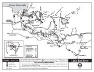
3.0 PROPOSED ACTION AND ALTERNATIVES<br />
3.1 Proposed Action<br />
The <strong>Little</strong> <strong>Rock</strong> <strong>District</strong> of the US Army Corps of Engineers proposes to acquire in fee approximately 2<br />
acres of private land at the following addresses in Rogers, Benton County, Arkansas: 2256 & 2258 N.<br />
2nd Street, Rogers, AR 72756 (see figure 1). The habitable structures would be demolished in the near<br />
future.<br />
BEAVER LAKE<br />
PROJECT OFFICE<br />
2258 N. 2 ND STREET<br />
2256 N. 2 ND STREET<br />
Figure 1. – <strong>Land</strong>s to Acquire: Parcels 2256 & 2258 N. 2 nd St., Rogers, Arkansas.<br />
Environmental Assessment of <strong>Beaver</strong> <strong>Lake</strong> PO <strong>Land</strong> <strong>Acquisition</strong>, Rogers, Arkansas<br />
July 2012<br />
3<br />
Environmental Assessment
3.2 Alternatives<br />
Alternative 1. Under Alternative 1 (No Action Alternative) the lands in question would not be<br />
purchased and the safety and security issues regarding the <strong>Beaver</strong> <strong>Lake</strong> <strong>Project</strong> <strong>Office</strong> would continue as<br />
status quo.<br />
Alternative 2. Alternative 2 (Proposed Action Alternative) involves the purchase in fee title of both<br />
parcels located at 2256 and 2258 N. 2 nd Street in Roger, Arkansas and future demolition and removal of<br />
all habitable structures. Structures such as existing sheds and/or garages may be retained for future<br />
project office use .<br />
Table 3.2 1 includes the comparative impacts from the No Action and the Proposed Action alternatives.<br />
Table 3-1. Comparative Impacts of Alternatives<br />
Resource Area No Action Proposed Action<br />
Physical Resources No beneficial or adverse effect No beneficial or adverse effect<br />
Cultural Resources No beneficial or adverse effect No beneficial or adverse effect<br />
Water Resources No beneficial or adverse effect No beneficial or adverse effect<br />
Wetlands No beneficial or adverse effect No beneficial or adverse effect<br />
Aquatic Resources No beneficial or adverse effect No beneficial or adverse effect<br />
Terrestrial Resources No beneficial or adverse effect. No beneficial or adverse effect<br />
Threatened and No beneficial or adverse effect<br />
No beneficial or adverse effect<br />
Endangered Species<br />
HTRW No beneficial or adverse effect Possible asbestos and lead paint<br />
abatement if habitable structures are<br />
demolished.<br />
Aesthetics No beneficial or adverse effect No beneficial or adverse effect<br />
Socio-Economic<br />
Resources<br />
No beneficial or adverse effect<br />
Minor insignificant change in tax<br />
revenues to the local economy from<br />
federal ownership of property.<br />
Moderate increase in safety and<br />
security for the <strong>Beaver</strong> PO.<br />
Cumulative No beneficial or adverse effect No beneficial or adverse effect<br />
Environmental Assessment of <strong>Beaver</strong> <strong>Lake</strong> PO <strong>Land</strong> <strong>Acquisition</strong>, Rogers, Arkansas<br />
July 2012<br />
4<br />
Environmental Assessment
4.0 AFFECTED ENVIRONMENT<br />
4.1 Physical Resources<br />
4.1.1 Topography/Physiography<br />
The following information is taken from the EDR Radius Map TM with GeoCheck® Report<br />
found in Appendix B (ECP Report).<br />
Environmental Assessment of <strong>Beaver</strong> <strong>Lake</strong> PO <strong>Land</strong> <strong>Acquisition</strong>, Rogers, Arkansas<br />
July 2012<br />
5<br />
Environmental Assessment
4.1.2 Soils<br />
The U.S. Department of Agriculture’s (USDA) Soil Conservation Service (SCS) leads the<br />
National Cooperative Soil Survey (NCSS) and is responsible for collecting, storing, maintaining<br />
and distributing soil survey information for privately owned lands in the United States. A soil<br />
map in a soil survey is a representation of soil patterns in a landscape. The following<br />
information is based on Soil Conservation Service SSURGO data for the two parcels of land in<br />
question.<br />
Soil Component Name:<br />
Captina<br />
Soil Surface Texture:<br />
silt loam<br />
Hydrologic Group:<br />
Class C - Slow infiltration rates. Soils with layers<br />
impeding downward movement of water, or soils<br />
with moderately fine or fine textures<br />
Soil Drainage Class:<br />
Moderately well drained<br />
Hydric Status:<br />
Partially hydric<br />
Corrosion Potential - Uncoated Steel: Moderate<br />
Depth to Bedrock Min:<br />
> 0 inches<br />
Depth to Watertable Min:<br />
> 61 inches<br />
Environmental Assessment of <strong>Beaver</strong> <strong>Lake</strong> PO <strong>Land</strong> <strong>Acquisition</strong>, Rogers, Arkansas<br />
July 2012<br />
6<br />
Environmental Assessment
Soil Layer Information<br />
Boundary Classification Saturated<br />
AASHTO<br />
Group<br />
Unified Soil hydraulic<br />
conductivity<br />
mico m/sec<br />
Layer Upper Lower Soil Texture<br />
Class<br />
1 0 inches 7 inches Silt loam Silt-Clay<br />
Material (more<br />
than 35 pct.<br />
Passing No.<br />
200), Silty<br />
Soils<br />
2 7 inches 20 inches Silt clay loam Silt-Clay<br />
Material (more<br />
than 35 pct.<br />
Passing No.<br />
200), Silty<br />
Soils<br />
3 20<br />
inches<br />
4 29<br />
inches<br />
5 48<br />
inches<br />
29 inches Silt clay loam Silt-Clay<br />
Material (more<br />
than 35 pct.<br />
Passing No.<br />
200), Silty<br />
Soils<br />
48 inches Very gravelly<br />
silty clay loam<br />
57 inches Extremely<br />
gravelly silty<br />
clay loam<br />
Silt-Clay<br />
Material (more<br />
than 35 pct.<br />
Passing No.<br />
200), Silty<br />
Soils<br />
Silt-Clay<br />
Material (more<br />
than 35 pct.<br />
Passing No.<br />
200), Silty<br />
Soils<br />
COARSE-<br />
GRAINED<br />
SOILS,<br />
Gravels,<br />
Gravels with<br />
fines, Clayey<br />
Gravel<br />
COARSE-<br />
GRAINED<br />
SOILS,<br />
Gravels,<br />
Gravels with<br />
fines, Clayey<br />
Gravel<br />
COARSE-<br />
GRAINED<br />
SOILS,<br />
Gravels,<br />
Gravels with<br />
fines, Clayey<br />
Gravel<br />
COARSE-<br />
GRAINED<br />
SOILS,<br />
Gravels,<br />
Gravels with<br />
fines, Clayey<br />
Gravel<br />
COARSE-<br />
GRAINED<br />
SOILS,<br />
Gravels,<br />
Gravels with<br />
fines, Clayey<br />
Gravel<br />
Max: 4<br />
Min: 1.4<br />
Max: 4<br />
Min: 1.4<br />
Max: 4<br />
Min: 1.4<br />
Max: 4<br />
Min: 1.4<br />
Max: 4<br />
Min: 1.4<br />
Soil<br />
Reaction<br />
(pH)<br />
Max: 6<br />
Min: 4.5<br />
Max: 6<br />
Min: 4.5<br />
Max: 6<br />
Min: 4.5<br />
Max: 6<br />
Min: 4.5<br />
Max: 6<br />
Min: 4.5<br />
4.2 Cultural Resources<br />
No cultural resources or historic properties including those eligible for the National Register of<br />
Historic Places were found within the 1-mile search radius of government records performed by<br />
Environmental Data Resources, Inc. (See Appendix B).<br />
4.3 Water Resources<br />
No surface water features are located in the immediate vicinity of the proposed acquisition sites.<br />
<strong>Beaver</strong> <strong>Lake</strong> is located approximately 1.5 miles to the east of the acquisition sites.<br />
Environmental Assessment of <strong>Beaver</strong> <strong>Lake</strong> PO <strong>Land</strong> <strong>Acquisition</strong>, Rogers, Arkansas<br />
July 2012<br />
7<br />
Environmental Assessment
4.4 Wetlands<br />
According to the U.S. Fish and Wildlife Service (USFWS) National Wetlands Inventory map, no<br />
jurisdictional wetland areas are identified on the site, adjacent properties or within the 1-mile<br />
radius search performed by EDR.<br />
4.5 Aquatic Resources<br />
There are no aquatic resources in the immediate area of the proposed land acquisitions.<br />
4.6 Terrestrial Resources<br />
4.6.1 Vegetation<br />
Vegetation in the immediate acquisition area is scarce due to the<br />
industrial/commercial/residential zoning found in the area. Vegetation exists as lawn grass,<br />
ornamental shrubs and trees.<br />
4.6.2 Wildlife<br />
Wildlife consists primarily of urban species such as song birds, small rodents, domestic cats and<br />
dogs, and the occasional scavenger such as raccoon and opossum.<br />
Environmental Assessment of <strong>Beaver</strong> <strong>Lake</strong> PO <strong>Land</strong> <strong>Acquisition</strong>, Rogers, Arkansas<br />
July 2012<br />
8<br />
Environmental Assessment
4.7 Threatened and Endangered Species<br />
EDR’s NEPACheck® Report (Appendix E of ECP Report in Appendix B of this EA) found the<br />
following Endangered Species List for Benton County, Arkansas. Bald Eagle, Cave Crayfish,<br />
Ozark Cavefish, and Gray Bat. However, none of these species or their habitat is located within<br />
the immediate area of the two parcels of land covered by this EA.<br />
Common Name Scientific Name Federal Status<br />
Birds<br />
Bald Eagle<br />
(Haliaeatus leucocephalus) Endangered<br />
Crustaceans<br />
Cave Crayfish (Cambarus aculabrum) Endangered<br />
Fishes<br />
Ozark Cavefish (Amblyopsis rosae) Endangered<br />
Mammals<br />
Gray bat (Myotis grisescens) Endangered<br />
4.8 Hazardous, Toxic, and Radioactive Wastes (HTRW)<br />
The EDR Radius Map TM with GeoCheck® Report included in Appendix D of the ECP Report<br />
(Appendix B) was used to determine the existence of any HTRW resources within or around the<br />
immediate vicinity of the proposed land acquisitions. The parcels are residential sites and do not<br />
nor did they ever contain or store any HTRW resources with the possible exclusion of asbestos<br />
and lead paint use in the construction of the houses on these parcels of land. All houses that are<br />
old enough to have asbestos have been renovated and it is unlikely they contain any asbestos<br />
containing materials. The interior woodwork of these houses has been repainted with several<br />
layer of paint over the years and so lead paint may still exist within the homes. Therefore, any<br />
renovation or demolition of these homes should be performed by an EPA certified firm per the<br />
EPA’s Renovation, Repair and Painting Rule (40CFR 745, subpart E) issued on April 22, 2008.<br />
4.9 Aesthetics<br />
The two parcels of land are located in a mixed industrial/commercial/residential zoning area.<br />
The actual properties are aesthetically similar to typical residential lots consisting of a residence,<br />
front and backyard and associated out buildings.<br />
4.10 Socio-Economic Resources<br />
The population within the project area is concentrated in a suburban city. Table 4.10-1 provides<br />
a comparative summary of population trends within the project area (city and county) and the<br />
State of Arkansas. The total population of the project area in 1980 was 17,429, with the current<br />
(2010) population estimated at 55,964. The 2010 population represents a 221% increase since<br />
1980. During the same time period the State of Arkansas had population increase of 27.5%.<br />
Environmental Assessment of <strong>Beaver</strong> <strong>Lake</strong> PO <strong>Land</strong> <strong>Acquisition</strong>, Rogers, Arkansas<br />
July 2012<br />
9<br />
Environmental Assessment
Table 4.10-1. Population Trends, 1980-2010 1<br />
County 1980<br />
Population<br />
1990<br />
Population<br />
2000<br />
Population<br />
2010<br />
Population<br />
Percent Change<br />
(1980-2010)<br />
Rogers (city) 17,429 24,692 38,829 55,964 221<br />
Benton (county) 78,115 97,499 153,406 221,339 183<br />
Arkansas (State) 2,286,534 2,350,725 2,673,400 2,915,918 27.5<br />
1<br />
U. S. Census Bureau, Census of Population.<br />
Table 4.10-2 portrays selected housing characteristics related to occupancy status, median value,<br />
vacancy rate and size of household. In 2010 there were a total of 23,213 housing units within the<br />
project area according to the 2010 U.S. Census. Approximately 74% of the housing units are<br />
single family, with the owner-occupancy rate approximating 60% in the project area.<br />
As indicated in Table 4.10-2 the median value of owner-occupied housing in 2010 was $154,100<br />
for the project area. The median values of owner-occupied housing and monthly contract rents<br />
are substantially higher in the project area than in the state overall.<br />
Table 4.10-2 Housing Characteristics, 2010<br />
County Total<br />
Housing<br />
Units<br />
Percent<br />
Vacant<br />
Percent<br />
Owner<br />
Occupied<br />
Median<br />
Value<br />
(Owner<br />
Occupied)<br />
Median<br />
Rent<br />
(Renter<br />
Occupied)<br />
Average<br />
Household<br />
Size<br />
(owner)<br />
Rogers 23,213 14.5 60.5 $154,100 $756 2.99<br />
Benton 91,973 13.0 69.6 $154,400 $705 2.78<br />
Arkansas 1,310,895 14.6 67.2 $105,400 $622 2.55<br />
Source: U. S. Census Bureau, Selected Housing Characteristics, 2008-2010 ACS Survey.<br />
Median household incomes in 2010 were $46,897 in the project area and $50,434 in Benton<br />
County according to the 2010 U.S. Census American Community Survey. The income levels<br />
within the project area are approximately 20% above the statewide median household income.<br />
Table 4.10-3 Median Household Income<br />
County 2000 1 2010 2<br />
Rogers $40,474 $46,897<br />
Benton $40,281 $50,434<br />
Arkansas $32,182 $39,267<br />
U.S. Census Bureau, 2000, Selected Economic Characteristics, 2000 Summary File 3.<br />
U. S. Census Bureau, 2010. Selected Economic Characteristics, 2006-2010 ACS Survey.<br />
Fourteen percent of the population within the project area was considered to be below the<br />
poverty level in 2010 according to the 2010 U.S. Census (Table 4.10-4). The relative share of the<br />
population below the poverty level for the project area is lower than for the State of Arkansas.<br />
The relative share of minority population in the project area is comparable that for the State of<br />
Arkansas (Table 4.10-4). According to the 2010 U.S. Census, 26% of the population within the<br />
project area consisted of minority populations in 2010 as compared to 23% for the State of<br />
Environmental Assessment of <strong>Beaver</strong> <strong>Lake</strong> PO <strong>Land</strong> <strong>Acquisition</strong>, Rogers, Arkansas<br />
July 2012<br />
10<br />
Environmental Assessment
Arkansas. The relative share of Hispanic population in the project is significantly greater than<br />
that for the State of Arkansas.<br />
% Hispanic<br />
Table 4.10-4 Population Below Poverty Level and Minority Population<br />
County Total<br />
% Minority<br />
% Persons Below<br />
2010<br />
2010 1 2010<br />
2010 2<br />
Population Population Population Poverty Level<br />
Rogers 55,964 26.3 31.5 14.4<br />
Benton 221,339 17.4 15.5 11.7<br />
Arkansas 2,915,918 23.0 6.4 18.0<br />
1<br />
Source: U.S. Census Bureau, 2010 Census.<br />
2<br />
Source: U.S. Census Bureau, American Community Survey, 2006-2010.<br />
According to the U.S. Department of Commerce, Bureau of Economic Analysis, total<br />
employment within the project area was 25,267 in 2010. Unemployment rate in the project area<br />
in 2010 was approximately 5.8%.<br />
Table 4.10-5 indicates employment by major industry sector for the project area. The<br />
manufacturing, services and retail trade sectors comprise over one-half of the total employment<br />
within the project area. Employment within the retail trade industry is of greatest magnitude in<br />
the project area.<br />
Table 4.10-5. Total Full and Part-Time Employment by Major Industry Sector by<br />
Place of Work, 2010<br />
Industry Sector Rogers Benton County<br />
Total Employment (civilian) 25,267 103,520<br />
Percent Distribution of Employment<br />
Farming, Forestry, Mining 0.5 2.0<br />
Construction 8.7 8.5<br />
Manufacturing 17.4 14.4<br />
Transp., Comm., Util. 2.8 4.4<br />
Wholesale Trade 3.2 3.2<br />
Retail Trade 23.5 23.2<br />
Finance, Insurance, Real Estate 4.3 5.2<br />
Prof, Sci, Admin Services 7.9 7.6<br />
Ed, Health, Social Services 14.9 16.1<br />
Arts, Rec, Food Services 8.6 7.2<br />
Government 1.4 2.2<br />
Source: US Census Bureau, 2006-2010 American Community Survey.<br />
Environmental Assessment of <strong>Beaver</strong> <strong>Lake</strong> PO <strong>Land</strong> <strong>Acquisition</strong>, Rogers, Arkansas<br />
July 2012<br />
11<br />
Environmental Assessment
5.0 ENVIRONMENTAL CONSEQUENCES<br />
5.1 Definition of Key Terms<br />
The following paragraphs define key terms used throughout this section.<br />
5.1.1 Direct Versus Indirect Impacts<br />
The terms impact and effect, are synonymous as used in this EA. Impacts may be determined to<br />
be beneficial or adverse, and may apply to the full range of natural, aesthetic, historic, cultural,<br />
and economic resources of the project area and its surroundings. Definitions and examples of<br />
direct and indirect impacts as used in this document are as follows:<br />
Direct Impact. A direct impact is caused by the proposed action, and occurs at the same time and<br />
place.<br />
Indirect Impact. An indirect impact is caused by the proposed action and is later in time or<br />
farther removed in distance, but is still reasonably foreseeable.<br />
Application of Direct versus Indirect Impacts. For direct impacts to occur, a resource must be<br />
present in a particular area. For example, if highly erodible soils were disturbed due to<br />
construction, there would be a direct impact to soils from erosion at the construction site.<br />
Sediment laden runoff would indirectly affect water quality in adjacent areas downstream from<br />
the construction site.<br />
5.1.2 Short-Term versus Long-Term Impacts<br />
In this context, short-term and long-term do not refer to any rigid time period and are determined<br />
on a case-by-case basis in terms of the environmental consequences of a proposed action. A<br />
summary impact matrix is presented at the end of Section 3 in Table 3.2-1. The summary impact<br />
matrix table illustrates the environmental impacts for each resource category associated with<br />
each of the alternatives considered in this EA.<br />
5.1.3 Significance<br />
The term “significant” as used in National Environmental Policy Act (NEPA) requires<br />
consideration of both the context and intensity of the impact evaluated. Significance can vary in<br />
relation to the context of a proposed action. For a proposed action, context may include<br />
consideration of effects on a national, regional, and/or local basis. Both short-term and longterm<br />
effects may be relevant. Factors contributing to the intensity of an impact include:<br />
• The degree to which the action affects public health or safety;<br />
• The proximity of the action to resources which are legally protected by various statutes<br />
and regulations such as jurisdictional wetlands, sites and buildings listed on or eligible for<br />
listing on the National Register of Historic Places, regulatory floodplains, and Federallylisted<br />
Threatened and Endangered species;<br />
• The degree to which the effects of the action on the quality of the human environment are<br />
likely to be highly uncertain or controversial;<br />
Environmental Assessment of <strong>Beaver</strong> <strong>Lake</strong> PO <strong>Land</strong> <strong>Acquisition</strong>, Rogers, Arkansas<br />
July 2012<br />
12<br />
Environmental Assessment
• Whether the action is related to other actions that are individually insignificant but<br />
cumulatively significant; and<br />
• Whether the action threatens to violate federal, state, or local law imposed for the<br />
protection of the environment.<br />
5.2 Physical Resources<br />
5.2.1 Topography/Physiography<br />
There would be no impacts to the topography/physiography of the proposed acquisition areas as<br />
a result of implementing the No Action Alternative or the proposed action.<br />
5.2.2 Soils<br />
Under the No Action Alternative, there would be no effect to soils in the proposed acquisition<br />
area.<br />
Under the Proposed Action Alternative, there would be no adverse effects to soils due to the<br />
proposed acquisition or future demolition of habitable structures.<br />
5.3 Cultural Resources<br />
The proposed action alternative and the no action alternative will not have any effect on known<br />
or unknown cultural resources. The Arkansas State Historic Preservation <strong>Office</strong>r has concurred<br />
with this determination (see Appendix A, Coordination Letters).<br />
5.4 Water Resources<br />
Under the No Action Alternative or the proposed action, there would be no change in water<br />
resources within the proposed acquisition parcels and surrounding area.<br />
5.5 Wetlands<br />
No jurisdictional wetlands exist within a 1-mile radius of the area. Therefore, under the No<br />
Action Alternative, or proposed action no wetlands will be impacted.<br />
5.6 Aquatic Resources<br />
No aquatic resources exist within a 1-mile radius of the area. Therefore, under the No Action<br />
Alternative, or proposed action no aquatic resources will be impacted.<br />
5.7 Terrestrial Resources<br />
5.7.1 Vegetation<br />
Under the No Action Alternative or the proposed action, no vegetation in the vicinity of the<br />
proposed action area would be affected. Any future actions resulting in the cutting of vegetation<br />
would be insignificant and would fall under normal maintenance of the project office property.<br />
Environmental Assessment of <strong>Beaver</strong> <strong>Lake</strong> PO <strong>Land</strong> <strong>Acquisition</strong>, Rogers, Arkansas<br />
July 2012<br />
13<br />
Environmental Assessment
5.7.2 Wildlife<br />
Under the No Action Alternative or the proposed action, no significant wildlife species in the<br />
vicinity of the proposed action area would be affected.<br />
5.8 Threatened and Endangered Species<br />
Since there are no T&E species in the acquisition area, there would be no impacts to threatened<br />
and endangered species as a result of implementing the No Action Alternative or the proposed<br />
action.<br />
5.9 Hazardous, Toxic, and Radioactive Wastes (HTRW)<br />
No HTRW resources exist in the proposed acquisition areas other than possible lead paint with<br />
the habitable structures. Due to the possible existence of asbestos or lead based paint, if<br />
demolition of the habitat structures occur in the future, they should be performed by an EPA<br />
certified firm per the EPA’s Renovation, Repair and Painting Rule (40CFR 745, subpart E)<br />
issued on April 22, 2008<br />
5.10 Aesthetic Resources<br />
No impacts to aesthetic resources would occur due to implementation of the No Action or<br />
proposed action alternatives.<br />
5.11 Socio-Economic Resources<br />
No impacts to socioeconomic resources would occur due to implementation of the No Action or<br />
proposed action alternatives. Changes in tax revenues to the local economy would be<br />
insignificant. The proposed action would provide for an increase in public safety and security<br />
for the <strong>Beaver</strong> PO.<br />
5.12 Cumulative Impacts<br />
Federal ownership of this property would have no significant impact on the amount of public<br />
versus private ownership of land in this area.<br />
Environmental Assessment of <strong>Beaver</strong> <strong>Lake</strong> PO <strong>Land</strong> <strong>Acquisition</strong>, Rogers, Arkansas<br />
July 2012<br />
14<br />
Environmental Assessment
6.0 CONCLUSIONS<br />
Alternative 1<br />
Implementation of Alternative 1 (No Action Alternative) would result in continued problems<br />
with the limited parking and maneuverability that currently exists for the <strong>Beaver</strong> <strong>Project</strong> <strong>Office</strong>.<br />
This translates into staff and public safety issues for visitors to the <strong>Beaver</strong> <strong>Project</strong> <strong>Office</strong>.<br />
Alternative 2<br />
Implementation of Alternative 2 (Proposed Action Alternative) would provide for additional<br />
parking and additional security for the <strong>Beaver</strong> <strong>Project</strong> <strong>Office</strong>.<br />
No environmental or socioeconomic effects that were considered likely to occur under the<br />
proposed action were determined to be significant. Unless explicitly stated, one cannot construe<br />
it to mean that any combination of effects can equate to a determination of significance.<br />
Significant impacts were determined based on the criteria established in 40 Code of Federal<br />
Regulations (CFR) 1508.27.<br />
Therefore, the implementation of the proposed action (acquisition of approximately 2.0 acres of<br />
residential property for <strong>Beaver</strong> <strong>Project</strong> <strong>Office</strong> use) would not have a significant adverse impact<br />
on the quality of the environment and therefore an environmental impact statement is not<br />
required.<br />
Environmental Assessment of <strong>Beaver</strong> <strong>Lake</strong> PO <strong>Land</strong> <strong>Acquisition</strong>, Rogers, Arkansas<br />
July 2012<br />
15<br />
Environmental Assessment
7.0 RELATIONSHIP OF PROJECT TO ENVIRONMENTAL REGULATIONS<br />
Guidance<br />
Archaeological and Historical Preservation<br />
Act, as Amended, 16 U.S.C. 469, et seq.<br />
National Historic Preservation Act, as Amended,<br />
16 U.S.C. 470A, et seq.<br />
Native American Graves Protection and Repatriation Act of<br />
1990 (P.L. 101-601; 104 Stat. 3048; 25 USC 3001-13)<br />
Clean Water Act, as Amended, 33 U.S.C. 466 et seq.<br />
Endangered Species Act, as Amended, 16 U.S.C. 1531, et seq.<br />
Farmland Protection Policy Act, 7 U.S.C. 4201, et seq.<br />
Federal Water <strong>Project</strong> Recreation Act, as Amended,<br />
16 U.S.C. 4601, et seq.<br />
Fish and Wildlife Coordination Act, as Amended,<br />
16 U.S.C. 4601, et seq.<br />
<strong>Land</strong> and Water Conservation Fund Act, as Amended,<br />
16 U.S.C. 4601, et seq.<br />
National Environmental Policy Act, as Amended,<br />
42 U.S.C. 4321, et seq.<br />
Rivers and Harbors Act, 33 U.S.C. 401, et seq.<br />
Floodplain Management, E.O. 11988<br />
Protection of Wetlands, E.O. 11990<br />
Protection and Enhancement of the Cultural<br />
Environment, E.O. 11593<br />
Prime or Unique Agricultural <strong>Land</strong>s NEPA,<br />
CEQ Memorandum August 11, 1980<br />
*Degree of Compliance<br />
FC<br />
FC<br />
NA<br />
NA<br />
FC<br />
FC<br />
FC<br />
FC<br />
FC<br />
FC<br />
FC<br />
FC<br />
FC<br />
FC<br />
FC<br />
*Definitions: FC = Full Compliance PC = Partial Compliance NA- Not Applicable;<br />
Full compliance will be attained after review and comment on the Environmental Assessment by the agencies listed<br />
in Appendix B - 30-Day Public Review Comments.<br />
The FONSI will not be signed and become Final until the proposed action achieves environmental compliance with<br />
applicable laws and regulations, as described above.<br />
Environmental Assessment of <strong>Beaver</strong> <strong>Lake</strong> PO <strong>Land</strong> <strong>Acquisition</strong>, Rogers, Arkansas<br />
July 2012<br />
16<br />
Environmental Assessment
8.0 LIST OF PREPARERS<br />
Jim Ellis, NEPA Specialist, Environmental Branch, Planning and Environmental Division, <strong>Little</strong><br />
<strong>Rock</strong> <strong>District</strong>, U.S. Army Corps of Engineers.<br />
Cherilyn Gibbs, Economist, Planning Branch, Planning and Environmental Division, <strong>Little</strong> <strong>Rock</strong><br />
<strong>District</strong>, U.S. Army Corps of Engineers.<br />
Environmental Assessment of <strong>Beaver</strong> <strong>Lake</strong> PO <strong>Land</strong> <strong>Acquisition</strong>, Rogers, Arkansas<br />
July 2012<br />
17<br />
Environmental Assessment
Appendix A – Coordination Letters<br />
Environmental Assessment of <strong>Beaver</strong> <strong>Lake</strong> PO <strong>Land</strong> <strong>Acquisition</strong>, Rogers, Arkansas<br />
July 2012<br />
18<br />
Environmental Assessment
DEPARTMENT OF THE ARMY<br />
LITTLE ROCK DISTRICT CORPS OF ENGINEERS<br />
POST OFFICE BOX 867<br />
LITTLE ROCK, ARKANSAS 72203-0867<br />
May 2, 2012<br />
Planning and Environmental <strong>Office</strong><br />
«fn» «ln»<br />
«title»<br />
«agency»<br />
«office»<br />
«add1»<br />
«add2»<br />
«city», «state» «zip»<br />
Dear «salutation» «ln»:<br />
The <strong>Little</strong> <strong>Rock</strong> <strong>District</strong>, Corps of Engineers <strong>Beaver</strong> <strong>Lake</strong> <strong>Project</strong> <strong>Office</strong> is located within the city limits<br />
of Rogers, Arkansas. The <strong>Project</strong> <strong>Office</strong> lies just south of the intersection of Arkansas State Hwy 62 and<br />
Second. The <strong>Project</strong> <strong>Office</strong> proposes to purchase in fee two (2) lots which are immediately adjacent and<br />
lay parallel to the south side of the <strong>Beaver</strong> <strong>Project</strong> <strong>Office</strong> property (see enclosed map). The addresses of<br />
the lots are 2256 & 2258 N. 2 nd Street, Rogers, Arkansas. The current parking lot configuration has<br />
presented several security and safety issues that impact employees as well as the public.<br />
Purchasing the two lots adjacent to the south side of the <strong>Beaver</strong> <strong>Project</strong> <strong>Office</strong> will allow additional<br />
property for a new parking lot and safe entrance into and out of the parking lot for employees and visitors.<br />
This purchase will also allow for additional security for the project office. The adjacent lot has a house<br />
and outbuildings that are within twenty feet of the south wall of the project office. All habitable<br />
structures on both properties will be removed in the immediate future.<br />
The Corps of Engineers is requesting information and comments that would assist in the preparation of an<br />
environmental assessment (EA) as required by the National Environmental Policy Act of 1969 and the<br />
Corps’ Engineer Regulation ER 200-2-2 “Procedures for Implementing NEPA”.<br />
Please submit any information or comments your agency may have by June 1, 2012 via letter or email. If<br />
comments are not received by this date, we will assume your agency has no comments or objections to<br />
the proposed action. If there are any questions or concerns, our environmental POC for this study is Mr.<br />
Jim Ellis at (501) 324-5629; email<br />
jim.d.ellis@usace.army.mil.<br />
Sincerely,<br />
Enclosure<br />
Dana O. Coburn<br />
Chief, Environmental Branch<br />
Environmental Assessment of <strong>Beaver</strong> <strong>Lake</strong> PO <strong>Land</strong> <strong>Acquisition</strong>, Rogers, Arkansas<br />
July 2012<br />
19<br />
Environmental Assessment
Environmental Assessment of <strong>Beaver</strong> <strong>Lake</strong> PO <strong>Land</strong> <strong>Acquisition</strong>, Rogers, Arkansas<br />
July 2012<br />
20<br />
Environmental Assessment
Jim Boggs<br />
Field Supervisor<br />
U.S. Fish and Wildlife Service<br />
Arkansas Field <strong>Office</strong><br />
110 South Amity Road, Suite 300<br />
Conway, AR 72032<br />
Michael P. Jansky<br />
Region 6 Environmental Review Coordinator<br />
U.S. Environmental Protection Agency<br />
Region 6<br />
<strong>Office</strong> of Planning & Coordination<br />
1445 Ross Avenue, Suite 1200<br />
6ENXP<br />
Dallas, TX 75202-2733<br />
Frances McSwain<br />
Director<br />
Arkansas Historic Preservation Program<br />
1500 Tower Building<br />
323 Center Street<br />
<strong>Little</strong> <strong>Rock</strong>, AR 72201<br />
Tracy L. Copeland<br />
Department of Finance & Administration<br />
Arkansas State Clearing House<br />
1515 West 7th Street, Room 412<br />
P.O. Box 3278<br />
<strong>Little</strong> <strong>Rock</strong>, AR 72203<br />
J. Randy Young<br />
Executive Director<br />
Arkansas Natural Resources Commission<br />
101 E. Capitol Avenue, Suite #350<br />
<strong>Little</strong> <strong>Rock</strong>, AR 72201-3827<br />
Teresa Marks<br />
Director<br />
Arkansas Dept of Environmental Quality<br />
5301 Northshore Drive<br />
North <strong>Little</strong> <strong>Rock</strong>, AR 72118-5317<br />
Loren Hitchcock<br />
Director<br />
Arkansas Game and Fish Commission<br />
2 Natural Resources Drive<br />
<strong>Little</strong> <strong>Rock</strong>, AR 72205<br />
Karen Smith<br />
Director<br />
Arkansas Natural Heritage Commission<br />
1500 Tower Building<br />
323 Center Street<br />
<strong>Little</strong> <strong>Rock</strong>, AR 72201<br />
David Friewald<br />
Director<br />
U.S. Geological Survey<br />
401 Hardin Road<br />
<strong>Little</strong> <strong>Rock</strong>, AR 72211<br />
Tony Russell<br />
Regional Director<br />
FEMA, Region VI<br />
Federal Regional Center<br />
800 North Loop 288<br />
Denton, TX 76210<br />
Edward Swaim<br />
Chief<br />
Arkansas Natural Resources Commission<br />
Water Resource Management Division<br />
101 E. Capitol, Suite 350<br />
<strong>Little</strong> <strong>Rock</strong>, AR 72201<br />
Paul K. Halverson<br />
Director of Health<br />
Arkansas Department of Health<br />
4815 West Markham<br />
<strong>Little</strong> <strong>Rock</strong>, AR 72205<br />
Michael Sullivan<br />
State Conservationist<br />
U.S. Department of Agriculture<br />
Natural Resources Conservation Service<br />
700 West Capitol Ave.<br />
Room 3416, Federal Building<br />
<strong>Little</strong> <strong>Rock</strong>, AR 72201<br />
Dan Flowers<br />
Director<br />
Arkansas Highway and Transportation Department<br />
10324 Interstate 30<br />
<strong>Little</strong> <strong>Rock</strong>, AR 72211<br />
Jeanene Peckham<br />
NEPA Specialist<br />
U.S. Environmental Protection Agency<br />
Region 6<br />
6WQ-EM<br />
1445 Ross Avenue, Suite 1200<br />
Dallas, TX 75202-2733<br />
Environmental Assessment of <strong>Beaver</strong> <strong>Lake</strong> PO <strong>Land</strong> <strong>Acquisition</strong>, Rogers, Arkansas<br />
July 2012<br />
21<br />
Environmental Assessment
United States Department of Agriculture<br />
~NRCS<br />
Natural Resources Conservation Service<br />
Room 3416, Federal Building<br />
700 West Capitol Avenue<br />
<strong>Little</strong> <strong>Rock</strong>, Arkansas 72201-3215<br />
HAY 0 4 2012<br />
Dana 0. Coburn<br />
Chief, Environmental Branch<br />
Department of the Army<br />
<strong>Little</strong> <strong>Rock</strong> <strong>District</strong> Corps of Engineers<br />
Post <strong>Office</strong> Box 867<br />
<strong>Little</strong> <strong>Rock</strong>, Arkansas 72203-0867<br />
Dear Ms. Coburn:<br />
This letter is in response to your request for information related to Prime Farmland and Farmland<br />
of Statewide Importance for the proposed construction of two lots located at 2256 & 2258 N.<br />
Street, Roger, Benton County, Arkansas. This area is not considered Prime Farmland or<br />
Farmland of Statewide Importance.<br />
Should you have any questions or need additional information, please call me at (501) 301-3172<br />
or email at nelson.rolong@ar.usda.gov.<br />
Sincerely,<br />
*/I~<br />
Nelson A. Rolong, PhD.<br />
Assistant State Soil Scientist<br />
Enclosure<br />
cc:<br />
Luis Hernandez, Soil Survey Region 16 Leader/State Soil Scientist, NRCS, <strong>Little</strong> <strong>Rock</strong>, AR<br />
Helping People Help the <strong>Land</strong><br />
An Equal Opportunity Provider and Employer
PART I (To be completed by Federal Agency)<br />
U.S. Department of Agriculture<br />
FARMLAND CONVERSION IMPACT RATING<br />
Name Of <strong>Project</strong> Corp of Engineers <strong>Beaver</strong> <strong>Lake</strong> <strong>Project</strong> <strong>Office</strong><br />
Proposed <strong>Land</strong> Use Parking lot<br />
PART II (To be complet£~9 by NRCS)<br />
Date Of <strong>Land</strong> Evaluation Request<br />
Federal Agency Involved<br />
County And State<br />
5/2112<br />
Dept of the Army Corps of Engineers<br />
Benton County, AR<br />
Date Request Received By NRCS<br />
... .<br />
Does the site contain prime, unique, statewide or local important farmland? Yes No Acres Irrigated I Average Farm Size<br />
(If no, the FPPA does not apply- do not complete additional parts of this fonn). 0 ~<br />
Major Crop(s) Farmable <strong>Land</strong> In Govt. Jurisdiction Amount Of Farmland As Defined in FPPA<br />
Acres: % Acres: %<br />
Name Of <strong>Land</strong> Evaluation system I.Jsed Name Of Local Site Assessment System I Date <strong>Land</strong> Evaluation Returned By NRCS<br />
PART Ill (To be completed by Federal Agency)<br />
Aitemative Site Rating<br />
-<br />
Site A Site 8 SiteC<br />
A. Total Acres To Be Converted Directly<br />
SiteD<br />
B. Total Acres To Be Converted Indirectly<br />
C. Total Acres In Site 0.0 0.0 0.0 0.0<br />
PART IV (To be completed by NRCS) Lemd Evaluation Information<br />
A. Total Acres Prime And Unique Farmland<br />
...<br />
B. Total Acres Statewide And Local·lmportant Farmland<br />
C. Percentage Of Farmland In County Or Local Govt. Unit To Be Converted<br />
D. Percentage Of Farmland In Govt. Jurisdiction V\lith Same Or Higher Relative Value<br />
PART V (To be completed by NRCS) <strong>Land</strong> Evaluation Criterion<br />
Relative Value Of Farmland To Be Converted (Scale of 0 to 100Points)<br />
PART VI (To be completed by Federal Agency)<br />
Site Assessment Criteria (These aiteria am explained i1 7 CFR 658.5(b)<br />
1. Area In Nonurban Use<br />
2. Perimeter In Nonurban Use<br />
3. Percent Of Site Being Farmed<br />
4. Protection Provided By State And Local Government<br />
5. Distance From Urban Builtup Area<br />
6. Distance To Urban Support Services<br />
7. Size Of Present Farm Unit Compared To Average<br />
8. Creation Of Nonfarmable Farmland<br />
9. Availability Of Farm Support Services<br />
10. On-Farm Investments<br />
11. Effects Of Conversion On Farm Support Services<br />
12. Compatibility \1\/ith Existing Agricultural Use<br />
Maximum<br />
Points<br />
0 0 0 0<br />
TOTAL SITE ASSESSMENT POINTS 160 0 0 0 0<br />
PART VII (To be compieted by Federal Agencyj<br />
Relative Value Of Farmland (From Part V) 100 0 0 0 0<br />
Total Site Assessment (From Part VI abow ora local<br />
site assessrrent) 160 0 0 0 0<br />
TOTAL POINTS (Total of above 21ines) 260 0 0 0 0<br />
I<br />
Was A Local Site Assessment Used?<br />
Site Selected: Date Of Selection<br />
Yes D No []<br />
Reason For Selection:<br />
(See Instructions on reverse side) Fonn AD-1006 (10-83)<br />
This form was electronically produced by National Production Sefllices Staff
STEPS IN THE PROCESSING THE FARMLAND AND CONVERSION IMPACT RATING FORM<br />
Step 1- Federal agencies involved in proposed projects that may convert farmland, as defined in the Farmland Protection<br />
Policy Act (FPPA) to nonagricultural uses, will initially complete Parts I and lll of the form.<br />
Step 2 - Originator will send copies A, 8 and C together with maps indicating locations of site(s), to the Natural Resources<br />
Conservation Service (NRCS) local field office and retain copy D for their files. (Note: NRCS has a field office in most counties<br />
in the U.S. The field office is usually located in the county seat. A list of field office locations are available from the NRCS<br />
State Conservationist in each state).<br />
Step 3 - NRCS will, within 45 calendar days after receipt of form, make a determination as to whether the site(s) of the proposed<br />
project contains prime, unique, statewide or local important farmland .<br />
. Step '4 - In cases where farmland covered by the FPPA will be converted by the proposed pr~ject, NRCS field offices will complete<br />
Parts II, IV and V of the form.<br />
Step 5 - NRCS will return copy A and 8 of the form to the Federal agency involved in the project (Copy C will be retained for<br />
NRCS records).<br />
Step 6 - The Federal agency involved in the proposed pr~ject will complete Parts VI and VII of the form.<br />
Step 7 - The Federal agency involved in the proposed project will make a dete1mination as to whether the proposed conversion<br />
is consistent with the FPPA and the agency's internal policies.<br />
INSTRUCTIONS FOR COMPLETING THE FARMLAND CONVERSION IMPACT RATING FORM<br />
Part 1: In completing the "County And State" questions list all the local governments that are responsible<br />
for local land controls where site(s)are to be evaluated.<br />
Part III: In completing item B (Total Acres To Be ConveJted Indirectly), include the following:<br />
1 . Acres not being directly converted but that would no longer be capable of being farmed after the conversion,<br />
because the conversion would restrict access to them.<br />
2. Acres planned to receive services from an infrastructure project as indicated in the project justification<br />
(e.g. highways, utilities) that will cause a direct conversion.<br />
Part VI: Do not complete Part VI if a local site assessment is used.<br />
Assign the maximum points for each site assessment criterion as shown in§ 658.5 (b) of CFR. In cases of<br />
corridor-type projects such as transportation, power line and flood control, criteria #5 and #6 will not apply<br />
and will. be weighed zero, however, criterion #8 will be weighed a maximum of 25 points, and criterion<br />
# 11 a maximum of 25 points.<br />
Individual Federal agencies at the national level, may assign relative weights among the 12 site assessment<br />
criteria other than those shown in the FPPA rule. In all cases where other weights are assigned relative acUustments<br />
must be made to maintain the maximum total weight points at 160.<br />
In rating alternative sites, Federal agencies shall consider each of the criteria and assign points within the<br />
limits established in the FPPA rule. Sites most suitable for protection under these criteria will receive the<br />
highest total scores, and sites least suitable, the lowestscores.<br />
Part VII: In computing the "Total Site Assessment Points" where a State or local site assessment is used<br />
and the total maximum number of points is other than 160, adjust the site assessment points to a base of 160.<br />
Example: if the Site Assessment maximum is 200 points, and alternative Site "A" is rated 180 points:<br />
Total points assigned Site A= 180 x 160 = 144 points for Site "A."<br />
Maximum points possible 200
From:<br />
To:<br />
Subject:<br />
Date:<br />
Jeanene Peckham<br />
Ellis, Jim D SWL<br />
<strong>Beaver</strong> <strong>Lake</strong> <strong>Project</strong> <strong>Office</strong> - NEPA Compliance<br />
Tuesday, May 08, 2012 8:00:20 AM<br />
EPA has no concerns about the purchase of additional adjacent property at the project office for safety<br />
and additonal security. Jeanene Peckham<br />
Jeanene Peckham<br />
ph. 214-665-6411<br />
fx. 214-665-6689<br />
EPA 6WQ-EM
U. S. Department of Homeland Security<br />
FEMA Region 6<br />
800 North Loop 288<br />
Denton, TX 76209-3698<br />
FEMA<br />
FEDERAL EMERGENCY MANAGEMENT AGENCY<br />
REGION VI<br />
MITIGATION DIVISION<br />
NOTICE REVIEW /ENVIRONMENTAL CONSULTATION<br />
D We have no comments to offer. We offer the following comments:<br />
WE WOULD REQUEST THAT THE LOCAL FLOODPLAIN ADMINISTRATORS BE<br />
CONTACTED FOR THE REVIEW AND POSSIBLE PERMIT REQUIREMENTS FOR<br />
THIS PROJECT. IF FEDERALLY FUNDED, WE WOULD REQUEST PROJECT TO<br />
BE IN COMPLIANCE WITH E011988 & EO 11990.<br />
Lance Job<br />
<strong>Project</strong> Engineer<br />
City of Rogers<br />
301 West Chestnut Street<br />
Rogers, AR 72756<br />
ljobe@rogersark.org<br />
479-621-1186<br />
REVIEWER:<br />
:Mayra q. Cf>iaz<br />
Floodplain Management and Insurance Branch<br />
Mitigation Division<br />
(940) 898-5541 DATE: May 10, 2012
ARKANSAS STATE HIGHWAY<br />
AND<br />
TRANSPORTATION DEPARTMENT<br />
Scott E. Bennett<br />
Director<br />
Telephone (501) 569-2000<br />
VoicenTY 711<br />
P.O. Box 2261<br />
<strong>Little</strong> <strong>Rock</strong>, Arkansas 72203-2261<br />
Telefax (501) 569-2400<br />
www.arkansashighways.com<br />
May 23,2012<br />
Ms. Dana 0. Coburn, Chief<br />
Environmental Branch<br />
<strong>Little</strong> <strong>Rock</strong> <strong>District</strong> Corps of Engineers<br />
Post <strong>Office</strong> Box 867<br />
<strong>Little</strong> <strong>Rock</strong>, Arkansas 72203-0867<br />
Dear Ms. Coburn:<br />
Re: <strong>Beaver</strong> <strong>Lake</strong> <strong>Project</strong> <strong>Office</strong> Expansion<br />
The information provided on the referenced project has been reviewed and we find no<br />
conflict between it and any proposed Department projects. Thank you for the opportunity<br />
to participate in the review process.<br />
Sincerely,<br />
~ t!!:~<br />
\of Engineer of Programs<br />
and Contracts Division
DEPARTMENT OF THE ARMY<br />
LITTLE ROCK DISTRICT CORPS OF ENGINEERS<br />
POST OFFICE BOX 867<br />
LITTLE ROCK, ARKANSAS 72203-0867<br />
May 2, 2012<br />
Planning and Environmental <strong>Office</strong><br />
Frances McSwain<br />
Director<br />
Arkansas Historic Preservation Program<br />
1500 Tower Building<br />
323 Center Street<br />
<strong>Little</strong> <strong>Rock</strong>, AR 72201<br />
AHPP<br />
MA'< 0 4 '?~r?<br />
Dear Ms. McSwain:<br />
The <strong>Little</strong> <strong>Rock</strong> <strong>District</strong>, Corps of Engineers <strong>Beaver</strong> <strong>Lake</strong> <strong>Project</strong> <strong>Office</strong> is located within the city limits<br />
of Rogers, Arkansas. The <strong>Project</strong> <strong>Office</strong> lies just south ofthe intersection of Arkansas State Hwy 62 and<br />
Second. The <strong>Project</strong> <strong>Office</strong> proposes to purchase in fee two (2) lots which are immediately adjacent and<br />
lay parallel to the south side of the <strong>Beaver</strong> <strong>Project</strong> <strong>Office</strong> property (see enclosed map). The addresses of<br />
the lots are 2256 & 2258 N. 2nd Street, Rogers, Arkansas. The current parking lot configuration has<br />
presented several security and safety issues that impact employees as well as the public.<br />
Purchasing the two lots adjacent to the south side of the <strong>Beaver</strong> <strong>Project</strong> <strong>Office</strong> will allow additional<br />
property for a new parking lot and safe entrance into and out of the parking lot for employees and visitors.<br />
This purchase will also allow for additional security for the project office. The adjacent lot has a house<br />
and outbuildings that are within twenty feet of the south wall of the project office. All habitable<br />
structures on both properties will be removed in the immediate future.<br />
The Corps of Engineers is requesting information and comments that would assist in the preparation of an<br />
environmental assessment (EA) as required by the National Environmental Policy Act of 1969 and the<br />
Corps' Engineer Regulation ER 200-2-2 "Procedures for Implementing NEPA".<br />
Please submit any information or comments your agency may have by June 1, 2012 via letter or email. If<br />
comments are not received by this date, we will assume your agency has no comments or objections to<br />
the proposed action. If there are any questions or concerns, our environmental POC for this study is Mr.<br />
Jim Ellis at (501) 324-5629; email<br />
jim.d.ellis@usace.army.mil.<br />
1:&.~~~<br />
Dana 0. Coburn<br />
Chief, Environmental Branch<br />
Enclosure<br />
0o1e ~-/-I]__)<br />
No known hisorlc propertf•s will M<br />
affected by this undertaking. This<br />
eft t determination could change<br />
s i tl t i
Appendix B – Environmental Condition of Property Report (ECP)<br />
Environmental Assessment of <strong>Beaver</strong> <strong>Lake</strong> PO <strong>Land</strong> <strong>Acquisition</strong>, Rogers, Arkansas<br />
July 2012<br />
22<br />
Environmental Assessment
Final<br />
ENVIRONMENTAL CONDITION OF PROPERTY<br />
REPORT (ECP)<br />
2256 & 2258 North Second Street, Rogers, Arkansas<br />
Prepared By:<br />
U.S. Army Corps of Engineers – <strong>Little</strong> <strong>Rock</strong> <strong>District</strong> Planning and Environmental Division<br />
– Environmental Branch 700 West Capitol Avenue, <strong>Little</strong> <strong>Rock</strong>, Arkansas 72201-3221<br />
July 2012<br />
US Army Corps<br />
Of Engineers<br />
<strong>Little</strong> <strong>Rock</strong> <strong>District</strong>
EXECUTIVE SUMMARY<br />
The <strong>Little</strong> <strong>Rock</strong> <strong>District</strong>, Corps of Engineers <strong>Beaver</strong> <strong>Lake</strong> <strong>Project</strong> <strong>Office</strong> is located within the<br />
city limits of Rogers, Arkansas. The <strong>Project</strong> <strong>Office</strong> lies just south of the intersection of Arkansas<br />
State Hwy 62 and Second. The <strong>Project</strong> <strong>Office</strong> proposes to purchase in fee two (2) lots which are<br />
immediately adjacent and lay parallel to the south side of the <strong>Beaver</strong> <strong>Project</strong> <strong>Office</strong> property (see<br />
Figure 1 in Appendix A). The addresses of the lots are 2256 & 2258 N. 2 nd Street, Rogers,<br />
Arkansas. The current parking lot configuration has presented several security and safety issues<br />
that impact employees as well as the public.<br />
Purchasing the two lots adjacent to the south side of the <strong>Beaver</strong> <strong>Project</strong> <strong>Office</strong> will allow<br />
additional property for a new parking lot and safe entrance into and out of the parking lot for<br />
employees and visitors. This purchase will also allow for additional security for the project<br />
office. The adjacent lot has a house and outbuildings that are within twenty feet of the south<br />
wall of the project office. All habitable structures on both properties will be removed in the<br />
immediate future.<br />
This Executive Summary provides a brief description of the current and former uses of the<br />
proposed parcels for acquisition and areas of potential environmental concern that were<br />
evaluated during the ECP process. Detailed information associated with the summary presented<br />
below is provided in the remaining portion of this document.<br />
SITE DESCRIPTION & HISTORICAL USE<br />
This ECP report covers two parcels of land that are located at 2256 & 2258 North 2 nd Street,<br />
Rogers, Benton County, Arkansas. The properties are bounded by a mix of<br />
residential/commercial property in all directions. Site maps are located in Appendix A and legal<br />
descriptions, warranty deeds, and the landowners Environmental Statement are provided in<br />
Appendix B. Appendix C provides photographs taken during a site visit in May of 2012.<br />
Environmental Data Resources, Inc. (EDR) reports are located in Appendix D & E.<br />
AREAS ASSESSED FOR ENVIRONMENTAL CONCERN<br />
• UST/AST - It does not appear that USTs or ASTs have historically existed on the two<br />
parcels in question or are currently present on these sites.<br />
• LAND FILLS - There were no signs of land filling or illegal waste disposal activities at<br />
either of the two parcels during the May or June site inspections.<br />
ES-1
• PITS, SUMPS, DRY WELLS -There were no signs of pits, sumps, drywells or catch<br />
basins at either of the two parcels during the May site inspections. Ultimate discharge is<br />
to the municipal sanitary sewer.<br />
• ASBESTOS - Due to the age of the habitable structures on the two parcels (> 50 years) it<br />
was assumed there could be asbestos containing materials such as floor tiles or other<br />
construction related materials. A direct inspection of the interior of the habitable<br />
structures was not possible at the time of the site inspections. Current owners of the<br />
properties, Charles A. and Ellen A. Townsend, who purchased the properties in 2001 and<br />
2002, have signed an environmental statement to the following affect:<br />
• PCB’s - There is no evidence of any Polychlorinated Biphenyl (PCB) containing<br />
equipment within the premises of these two parcels of land.<br />
• LEAD - No survey was conducted to determine the presence of lead base paint in any of<br />
the habitable structures on either parcel of land. Due to the Pre-1978 age of the structures<br />
and the owners’ environmental statement (see Appendix B) that there are multiple layers<br />
of paint on wooden structures within the houses, any future remodeling or demolition<br />
should be performed by an EPA certified firm per the EPA’s Renovation, Repair and<br />
Painting Rule (40CFR 745, subpart E) issued on April 22, 2008.<br />
• RADON - Although no specific radon gas test was performed at either of the properties,<br />
the USEPA Map of Radon Zones for Benton County, Arkansas confirms that the county<br />
lies within priority zone 2, which has a predicted average indoor screening level of<br />
>=2,0pCi/L and
the storage, release, treatment or disposal of hazardous substances or petroleum products.<br />
Findings were also based on visual observations during the May site visit.<br />
ES-3
Table of Contents<br />
EXECUTIVE SUMMARY .................................................................................................................................... ES - 1<br />
1.0 INTRODUCTION ............................................................................................................................................... 1<br />
1.1 PURPOSE OF ENVIRONMENTAL CONDITION OF PROPERTY (ECP) ....................................................................... 1<br />
1.2 SCOPE OF REPORT ............................................................................................................................................... 2<br />
2.0 SITE LOCATION AND PHYSICAL DESCRIPTION ................................................................................................... 3<br />
2.1 SITE LOCATION .................................................................................................................................................... 3<br />
2.2 ASSET INFORMATION .......................................................................................................................................... 3<br />
2.3 PHYSICAL DESCRIPTION ....................................................................................................................................... 3<br />
2.4 SITE HYDROLOGY AND GEOLOGY ........................................................................................................................ 4<br />
2.4.1 Surface Water Characteristics ..................................................................................................................... 4<br />
2.4.2 Soil Characteristics ...................................................................................................................................... 5<br />
2.5 SITE UTILITIES ...................................................................................................................................................... 7<br />
2.6 WATER SUPPLY WELLS & SEPTIC SYSTEMS .......................................................................................................... 7<br />
3.0 SITE HISTORY ................................................................................................................................................... 8<br />
3.1 HISTORY OF OWNERSHIP .................................................................................................................................... 8<br />
3.2 PAST USES AND OPERATIONS .............................................................................................................................. 8<br />
4.0 ADJACENT PROPERTIES .................................................................................................................................... 9<br />
5.0 REVIEW OF REGULATORY INFORMATION ...................................................................................................... 10<br />
5.1 FEDERAL ENVIRONMENTAL RECORDS ............................................................................................................... 10<br />
5.1.1 Federal CERCLIS NFRAP site List ................................................................................................................ 10<br />
5.1.2 Federal RCRA CORRACTS facilities list ....................................................................................................... 10<br />
5.1.3 Federal RCRA generators list ..................................................................................................................... 10<br />
5.2 STATE AND LOCAL ENVIRONMENTAL RECORDS ................................................................................................ 11<br />
5.2.1 State and tribal leaking storage tank lists ................................................................................................. 11<br />
5.2.2 State and tribal registered storage tank lists ............................................................................................ 11<br />
5.3 UNMAPPED SITES .............................................................................................................................................. 12<br />
6.0 SITE INVESTIGATION AND REVIEW OF HAZARDS ............................................................................................ 13<br />
6.1 UNDERGROUND/ABOVEGROUND STORAGE TANKS (USTS/ASTS) .................................................................... 13<br />
6.2 INVENTORY OF CHEMICALS / HAZARDOUS SUBSTANCES .................................................................................. 13<br />
6.3 WASTE DISPOSAL SITES ..................................................................................................................................... 13<br />
6.4 PITS, SUMPS, DRYWELLS, AND CATCH BASINS .................................................................................................. 13<br />
6.5 ASBESTOS CONTAINING MATERIAL (ACM) ........................................................................................................ 13<br />
6.6 POLYCHLORINATED BIPHENYL CONTAINING EQUIPMENT ................................................................................ 14<br />
6.7 LEAD .................................................................................................................................................................. 14<br />
6.8 RADON .............................................................................................................................................................. 14<br />
6.9 UNEXPLODED ORDNANCE ................................................................................................................................. 14<br />
6.10 RADIOACTIVE MATERIALS ............................................................................................................................... 14<br />
7.0 REVIEW OF SPECIAL RESOURCES .................................................................................................................... 16<br />
7.1 LAND USE .......................................................................................................................................................... 16<br />
7.2 WETLANDS ........................................................................................................................................................ 16<br />
7.3 100-YEAR FLOOD PLAIN ..................................................................................................................................... 16<br />
7.4 NATURAL AREAS ................................................................................................................................................ 16<br />
7.5 CULTURAL RESOURCES ...................................................................................................................................... 16
8.0 CONCLUSIONS ................................................................................................................................................ 16<br />
9.0 REFERENCES ................................................................................................................................................... 18<br />
APPENDIX A – MAPS ............................................................................................................................................ 19<br />
APPENDIX B – WARRANTY DEEDS ........................................................................................................................ 22<br />
APPENDIX C – SITE VISIT PHOTOS ........................................................................................................................ 45<br />
APPENDIX D – EDR RADIUS MAP REPORT WITH GEOCHECK® ............................................................................ 61<br />
APPENDIX E - EDR NEPACHECK® REPORT ........................................................................................................... 161<br />
FIGURES<br />
FIGURE 1 - PROPOSED LANDS FOR ACQUISITION ..................................................................................................................... 20<br />
FIGURE 2 - ADJACENT PROPERTIES ....................................................................................................................................... 21<br />
FIGURE 3 - LANDOWNERS ENVIRONMENTAL STATEMENT ......................................................................................................... 44<br />
FIGURE 4 - USACOE, BEAVER PO, NORTH OF PROPERTIES ..................................................................................................... 46<br />
FIGURE 5 - RESIDENTIAL, EAST OF PROPERTIES ....................................................................................................................... 47<br />
FIGURE 6 - HEAD START, EAST OF PROPERTIES ....................................................................................................................... 48<br />
FIGURE 7 – RESIDENTIAL, SOUTH OF PROPERTIES.................................................................................................................... 49<br />
FIGURE 8 - 2256 N. 2ND ST., FRONT VIEW FROM N. 2ND STREET ............................................................................................ 50<br />
FIGURE 9 - 2256 N. 2ND ST., GARAGE APARTMENT BEHIND RESIDENCE .................................................................................... 51<br />
FIGURE 10 - 2256 N. 2ND ST., BACK VIEW OF RESIDENCE....................................................................................................... 52<br />
FIGURE 11 - 2256 N. 2ND ST., SHOP BUILDING .................................................................................................................... 53<br />
FIGURE 12 - 2256 N. 2ND ST., BACK OF SHOP BUILDING ........................................................................................................ 54<br />
FIGURE 13 - 2258 N. 2ND ST., FRONT VIEW FROM N. 2ND STREET .......................................................................................... 55<br />
FIGURE 14 - 2258 N. 2ND ST., BACK VIEW OF RESIDENCE....................................................................................................... 56<br />
FIGURE 15 - 2258 N. 2ND ST., OUT BUILDING (SMALL GARAGE) ............................................................................................. 57<br />
FIGURE 16 - 2258 N. 2ND ST., BACK OF SMALL GARAGE (OUT BUILDING) ................................................................................. 58<br />
FIGURE 17 - 2256 & 2258 N. 2ND ST., TYPICAL OPEN BACK OF PROPERTIES ............................................................................. 59<br />
FIGURE 18 - 2256 & 2258 N. 2ND ST., BACK OF BOTH RESIDENCES......................................................................................... 60
List of Acronyms and Abbreviations<br />
ACM<br />
AST<br />
ASTM<br />
CERCLA<br />
CERCLIS<br />
CESQG<br />
CFR<br />
CORRACTS<br />
ECP<br />
EDR<br />
FEMA<br />
kg<br />
LBP<br />
NPL<br />
PCB<br />
pCi/L<br />
PWS<br />
RCRA<br />
RCRAInfo<br />
USACE<br />
USEPA<br />
USGS<br />
UST<br />
asbestos-containing material<br />
aboveground storage tank<br />
American Society for Testing and Materials<br />
Comprehensive Environmental Response, Compensation, and<br />
Liability Act<br />
CERCLA Information System<br />
conditionally exempt small-quantity generator<br />
Code of Federal Regulations<br />
corrective action sites<br />
Environmental Condition of Property<br />
Environmental Data Resources, Inc.<br />
Federal Emergency Management Agency<br />
kilogram<br />
lead-based paint<br />
National Priorities List<br />
polychlorinated biphenyl<br />
picocuries per liter<br />
Public Water Supply<br />
Resource Conservation and Recovery Act<br />
RCRA Information Database<br />
U.S. Army Corps of Engineers<br />
U.S. Environmental Protection Agency<br />
U.S. Geological Society<br />
underground storage tank
1.0 INTRODUCTION<br />
The <strong>Little</strong> <strong>Rock</strong> <strong>District</strong>, Corps of Engineers <strong>Beaver</strong> <strong>Lake</strong> <strong>Project</strong> <strong>Office</strong> is located within the<br />
city limits of Rogers, Arkansas. The <strong>Project</strong> <strong>Office</strong> lies just south of the intersection of Arkansas<br />
State Hwy 62 and Second. The <strong>Project</strong> <strong>Office</strong> proposes to purchase in fee two (2) lots which are<br />
immediately adjacent and lay parallel to the south side of the <strong>Beaver</strong> <strong>Project</strong> <strong>Office</strong> property (see<br />
Figure 1 in Appendix A). The addresses of the lots are 2256 & 2258 N. 2 nd Street, Rogers,<br />
Arkansas. The current parking lot configuration has presented several security and safety issues<br />
that impact employees as well as the public.<br />
Purchasing the two lots adjacent to the south side of the <strong>Beaver</strong> <strong>Project</strong> <strong>Office</strong> will allow<br />
additional property for a new parking lot and safe entrance into and out of the parking lot for<br />
employees and visitors. This purchase will also allow for additional security for the project<br />
office. The adjacent lot has a house and outbuildings that are within twenty feet of the south<br />
wall of the project office. All habitable structures on both properties will be removed in the<br />
immediate future.<br />
1.1 PURPOSE OF ENVIRONMENTAL CONDITION OF PROPERTY (ECP)<br />
The following is taken from Section 14-5 of Engineer Regulation ER 200-2-3 dated 29 October<br />
2010: “Generally. USACE will assess, determine and document the environmental condition of<br />
property in an ECP Report. An ECP Report summarizes the historical, cultural, and<br />
environmental conditions of the property subject to the real estate transaction and includes<br />
references to publicly available and related reports, studies, and permits. It provides an accurate<br />
summary of the environmental condition of the property. The ECP Report is an integral part of<br />
the Report of Availability (ROA) or the Disposal Report which form the basis for the USACE<br />
official with delegated authority to approve the real property transaction and for the preparation<br />
of the required legal documents, land use controls and covenants that may be required for a<br />
covered transaction. “<br />
The ECP Report must comply with applicable standards for performing either a Phase I or Phase<br />
II Environmental Site Assessment as defined in American Society for Testing and Materials<br />
(“ASTM”) Standard E 1527–05 entitled, “Standard Practice for Environmental Site<br />
Assessments: Phase I Environmental Site Assessment Process,” or ASTM E 1903 (Standard<br />
Guide for Environmental Site Assessments: Phase II Environmental Site Assessment Process), as<br />
appropriate.<br />
The <strong>Beaver</strong> <strong>Lake</strong> <strong>Project</strong> <strong>Office</strong> has a need to purchase two lots which are immediately adjacent<br />
and lay parallel to the south side of the <strong>Beaver</strong> <strong>Project</strong> <strong>Office</strong> property. The <strong>Beaver</strong> <strong>Project</strong><br />
<strong>Office</strong> is located within the city limits of Rogers just south of the intersection of State Hwy 62<br />
and Second Street which leads to downtown. The <strong>Project</strong> <strong>Office</strong> parking lot is configured<br />
running parallel between the project office and Second Street. This parking lot has a narrow lane<br />
wide enough for only one vehicle to enter or exit at a time. The narrow lane has perpendicular<br />
1
parking on each side which allows for approximately twenty two vehicles to park at a time. This<br />
includes employee parking. The narrow lane terminates at the last two parking spaces with no<br />
turn-around area. This design only allows for the vehicle to pull into a parking space and then<br />
back out and exit. Vehicles pulling boats, RV's or semi trucks will pull into the parking lot not<br />
realizing there is no turnaround and will have to back out of the parking lot onto Second Street or<br />
employees have to open the secure compound for those vehicles to enter and travel past all<br />
buildings and turnaround. This places both security and safety of employees and Government<br />
property at high risk.<br />
The narrow width of the lot the office resides on precludes an extension and turnaround<br />
modification without additional property. Purchasing the two lots adjacent to the south side of<br />
the <strong>Beaver</strong> <strong>Project</strong> <strong>Office</strong> will allow additional property for a new parking lot and safe entrance<br />
into and out of the parking lot for employees and visitors. This purchase will also allow for<br />
additional force protection for the project office. The adjacent lot has a house and outbuildings<br />
that are within twenty feet of the south wall of the project office. Presently, there is no way of<br />
assessing any security issues from terrorist or criminal type persons or their activities against the<br />
<strong>Beaver</strong> <strong>Project</strong> <strong>Office</strong>. Purchasing of these lots will allow for a safer, egress and ingress, securer<br />
facility for the employees and visitors to the <strong>Beaver</strong> <strong>Project</strong> <strong>Office</strong>.<br />
1.2 SCOPE OF REPORT<br />
This ECP report covers two parcels of land that are located at 2256 & 2258 North 2 nd Street,<br />
Rogers, Benton County, Arkansas. The properties are bounded by a mix of<br />
residential/commercial property in all directions. Site maps are located in Appendix A and legal<br />
descriptions, warranty deeds, and the landowners Environmental Statement are provided in<br />
Appendix B. Appendix C provides photographs taken during a site visit in May of 2012.<br />
Environmental Data Resources, Inc. (EDR) reports are located in Appendix D & E.<br />
2
2.0 SITE LOCATION AND PHYSICAL DESCRIPTION<br />
2.1 SITE LOCATION<br />
The two (2) properties covered under this ECP are located in the central portion of Benton<br />
County, Arkansas, within the city limits of Rogers, Arkansas. The site is located in a mixture of<br />
residential, commercial and small industry area located in the northeast corner of Rogers,<br />
Arkansas. Figure 1 in Appendix A provides a general site location map.<br />
2.2 ASSET INFORMATION<br />
Parcel Name(s) and Address(es):<br />
Property Owner(s):<br />
2256 & 2258 North 2nd Street, Rogers, AR<br />
Charles A. & Ellen A. Townsend<br />
Date of Ownership: 2256: May 2001; 2258: June 2002<br />
Current Occupant:<br />
Charles A. & Ellen A. Townsend<br />
Zoning:<br />
Parcels (I-1, light industrial)<br />
County, State:<br />
Benton, Arkansas<br />
USGS Quadrangle(s): Rogers, AR: 1976<br />
Section/Township/Range: Section 01, Township 19, Range 30<br />
Latitude/longitude: 36° 21’ 11.52’’/ 94° 7’ 2.64’’<br />
Legal Description:<br />
The subject properties consist of two parcels of land, described as parcels 02-00740-000 and 02-<br />
00739-000 (see Appendix B). Copies of the warranty deeds, which include accurate legal<br />
descriptions, are also provided in Appendix B.<br />
2.3 PHYSICAL DESCRIPTION<br />
3
The parcels in question are described as residential lots consisting of approximately 1.00 acres<br />
each. No timber acreage is included in the parcels. The parcel located at 2256 North 2 nd Street<br />
contains two residential improvements, the first a single family domicile of approximately 1,752<br />
square feet and the second, a single family domicile/garage containing approximately 1,056<br />
square feet and a utility building of approximately 600 square feet. Each lot contains a<br />
residence and several out buildings. The parcel located at 2258 North 2 nd Street contains one<br />
single family domicile of approximately 1, 432 square feet and a detached garage.<br />
2.4 SITE HYDROLOGY AND GEOLOGY<br />
2.4.1 Surface Water Characteristics<br />
No surface water features are located in the immediate vicinity of the proposed acquisition sites.<br />
<strong>Beaver</strong> <strong>Lake</strong> is located approximately 1.5 miles to the east of the acquisition sites.<br />
According to the Federal Emergency Management Agency (FEMA) Flood Insurance Rate Map,<br />
Community Panel 05007C0280J, the sites are not included in the 100-year floodplain elevation<br />
or the 500-year floodplain elevation (see Appendix D & E for EDR flood plain data).<br />
EDR Local/Regional Water Agency records provide water well information to assist the<br />
environmental professional in assessing sources that may impact ground water flow direction,<br />
and in forming an opinion about the impact of contaminant migration on nearby drinking water<br />
wells.<br />
WELL SEARCH DISTANCE INFORMATION<br />
DATABASE<br />
SEARCH DISTANCE (miles)<br />
Federal USGS 1.000<br />
Federal FRDS PWS Nearest PWS within 1 mile<br />
State Database 1.000<br />
FEDERAL USGS WELL INFORMATION<br />
WELL ID<br />
LOCATION FROM TARGET POINT<br />
USGS2622084 ½ - 1 Mile NE<br />
USGS 2621911 ½ - 1 Miles NNW<br />
FEDERAL FRDS PUBLIC WATER SYSTEM INFORMATION<br />
WELL ID<br />
LOCATION FROM TARGET POINT<br />
No PWS System Found<br />
4
STATE DATABASE WELL INFORMATION<br />
WELL ID<br />
LOCATION FROM TARGET POINT<br />
No Wells Found<br />
2.4.2 Soil Characteristics<br />
The U.S. Department of Agriculture’s (USDA) Soil Conservation Service (SCS) leads the<br />
National Cooperative Soil Survey (NCSS) and is responsible for collecting, storing, maintaining<br />
and distributing soil survey information for privately owned lands in the United States. A soil<br />
map in a soil survey is a representation of soil patterns in a landscape. The following<br />
information is based on Soil Conservation Service SSURGO data for the two parcels of land in<br />
question.<br />
Soil Component Name:<br />
Soil Surface Texture:<br />
Hydrologic Group:<br />
Soil Drainage Class:<br />
Hydric Status:<br />
Captina<br />
silt loam<br />
Class C - Slow infiltration rates. Soils with layers<br />
impeding downward movement of water, or soils<br />
with moderately fine or fine textures<br />
Moderately well drained<br />
Partially hydric<br />
Corrosion Potential - Uncoated Steel: Moderate<br />
Depth to Bedrock Min:<br />
Depth to Watertable Min:<br />
> 0 inches<br />
> 61 inches<br />
5
Table 1 - Soil Layer Information<br />
Boundary Classification Saturated<br />
Layer Upper Lower Soil Texture<br />
Class<br />
AASHTO<br />
Group<br />
Unified Soil<br />
hydraulic<br />
conductivity<br />
mico m/sec<br />
Soil<br />
Reaction<br />
(pH)<br />
1 0 inches 7 inches Silt loam Silt-Clay<br />
Material (more<br />
than 35 pct.<br />
Passing No.<br />
200), Silty<br />
Soils<br />
COARSE-<br />
GRAINED<br />
SOILS,<br />
Gravels,<br />
Gravels with<br />
fines, Clayey<br />
Gravel<br />
Max: 4<br />
Min: 1.4<br />
Max: 6<br />
Min: 4.5<br />
2 7 inches 20 inches Silt clay loam Silt-Clay<br />
Material (more<br />
than 35 pct.<br />
Passing No.<br />
200), Silty<br />
Soils<br />
COARSE-<br />
GRAINED<br />
SOILS,<br />
Gravels,<br />
Gravels with<br />
fines, Clayey<br />
Gravel<br />
Max: 4<br />
Min: 1.4<br />
Max: 6<br />
Min: 4.5<br />
3 20<br />
inches<br />
29 inches Silt clay loam Silt-Clay<br />
Material (more<br />
than 35 pct.<br />
Passing No.<br />
200), Silty<br />
Soils<br />
COARSE-<br />
GRAINED<br />
SOILS,<br />
Gravels,<br />
Gravels with<br />
fines, Clayey<br />
Gravel<br />
Max: 4<br />
Min: 1.4<br />
Max: 6<br />
Min: 4.5<br />
4 29<br />
inches<br />
48 inches Very gravelly<br />
silty clay loam<br />
Silt-Clay<br />
Material (more<br />
than 35 pct.<br />
Passing No.<br />
200), Silty<br />
Soils<br />
COARSE-<br />
GRAINED<br />
SOILS,<br />
Gravels,<br />
Gravels with<br />
fines, Clayey<br />
Gravel<br />
Max: 4<br />
Min: 1.4<br />
Max: 6<br />
Min: 4.5<br />
5 48<br />
inches<br />
57 inches Extremely<br />
gravelly silty<br />
clay loam<br />
Silt-Clay<br />
Material (more<br />
than 35 pct.<br />
Passing No.<br />
200), Silty<br />
Soils<br />
COARSE-<br />
GRAINED<br />
SOILS,<br />
Gravels,<br />
Gravels with<br />
fines, Clayey<br />
Gravel<br />
Max: 4<br />
Min: 1.4<br />
Max: 6<br />
Min: 4.5<br />
6
2.5 SITE UTILITIES<br />
The properties in question are serviced by public utilities and private septic systems. Water and<br />
trash services are provided by Rogers Water Utilities. Electricity is provided by Carroll Electric<br />
Cooperative Corporation and natural gas is provided by Arkansas Western Gas Company. An<br />
environmental statement signed by the owners states that the septic systems of both properties<br />
were replaced in 2010 and are in good working order (see Appendix B, <strong>Land</strong>owners<br />
Environmental Statement).<br />
2.6 WATER SUPPLY WELLS & SEPTIC SYSTEMS<br />
As shown in Section 2.4.1, there are no PWS System wells within one mile of the Site. Because<br />
the Site is served by a public sanitary sewer system, there are no septic systems on the Site, and<br />
no known systems were identified in the area.<br />
7
3.0 SITE HISTORY<br />
3.1 HISTORY OF OWNERSHIP<br />
Warranty deeds were reviewed back to 1926. Appendix B contains the warranty deeds for both<br />
properties.<br />
Warranty deed information for 2256 N. 2 nd Street includes the following:<br />
• May 2, 2001- William B. Moon and Dorothy June Moon, husband and wife and William<br />
M. Maloney and Virginia M. Maloney, husband and wife to Charles A. Townsend and<br />
Ellen A. Townsend, husband and wife.<br />
• January 10, 1986 – Juanita I. Bowman, widow of James M. Bowman to William M.<br />
Moon and Virginia M. Moon, as joint tenants with right of survivorship and not as<br />
tenants in common.<br />
• March 28, 1980 – Edwin Franklin and Ann Imogene Pinkley Franklin, husband and wife<br />
to James M. Bowman and Juanita I. Bowman, husband and wife.<br />
• September 29, 1975 – Edward D. Briscoe, a single person to Anna Imogene Pinkley<br />
Franklin and Edwin Franklin.<br />
Warranty deed information for 2258 N. 2 nd Street includes the following:<br />
• June 6, 2002 – James R. Deichman, a single person to Charles A. Townsend and Ellen A.<br />
Townsend, husband and wife.<br />
• April 14, 1964 - Thad Rand and Ruth Rand to James R. Deichman and Eleanor<br />
Deichman, husband and wife.<br />
• March 4, 1946 – Charley Duty and Lois (Lucy) Duty to Thad Rand and Ruth Rand.<br />
• February 28, 1946 – Rella Gaines formerly Rella Duty his wife to Charley Duty.<br />
• February 3, 1919 – B.F. Bryant and Tina L. Bryant to John R. Duty.<br />
3.2 PAST USES AND OPERATIONS<br />
The properties in question have always been used as residential properties. There is no evidence<br />
that either property were used for the storage, disposal, and or release of any hazardous<br />
substances.<br />
8
4.0 ADJACENT PROPERTIES<br />
Figure 2 in Appendix A provides a 2012 aerial view of the two properties and adjacent<br />
properties. The properties are bounded by the <strong>Beaver</strong> <strong>Lake</strong> <strong>Project</strong> <strong>Office</strong> to the north; an open<br />
field with few trees to the west zoned as light industrial; another residence and light industry to<br />
the south; and commercial property to the west. Table 2 provides a list of adjacent properties<br />
with their directional location from the Site. The zoning of the adjacent parcels is also listed in<br />
Table 2. Figures 3 -7 provide views of adjacent properties and surrounding land use.<br />
Table 2 - List of Adjacent Properties<br />
Direction<br />
From Site<br />
Name/Type of Property Addresses Zoning<br />
North<br />
Heavy Industrial/Highway<br />
Commercial Property on the<br />
North side of the parcels<br />
North 2 nd Street and West<br />
Hudson Road<br />
I-2/C-2<br />
West<br />
Light Industrial Property<br />
(undeveloped) on the West side<br />
of the parcels<br />
N/A I-1<br />
South<br />
Residential/Light Industrial<br />
Property on the South side of the<br />
parcels<br />
Stribling Drive and North 2 nd<br />
Street<br />
I-1<br />
East<br />
Residential/Highway Commercial<br />
Property on the East side of the<br />
parcels<br />
North 2 nd Street and Industrial<br />
Drive<br />
C-2<br />
<strong>Land</strong> use at the adjacent properties does not appear to have changed significantly over the years<br />
and does not appear to have impacted the environmental conditions of the two properties in<br />
question.<br />
9
5.0 REVIEW OF REGULATORY INFORMATION<br />
A component of the ECP is the review of all reasonably obtainable federal, state, and local<br />
government records for the Site and surrounding properties, where there has been a release or<br />
likely release of any hazardous substance or any petroleum product, and which is likely to cause<br />
or contribute to a release or threatened release of any hazardous substance or any petroleum<br />
product on the Federal real property. A regulatory database summary was acquired from EDR<br />
on April 17, 2012. The regulatory database summary consolidates standard federal, state, local,<br />
and tribal environmental record sources based on ASTM recommended minimum search<br />
distances from the Site. Copies of the complete EDR reports are included in Appendix D & E.<br />
5.1 FEDERAL ENVIRONMENTAL RECORDS<br />
5.1.1 Federal CERCLIS NFRAP site List<br />
CERC-NFRAP: Archived sites are sites that have been removed and archived from the inventory<br />
of CERCLIS sites. Archived status indicates that, to the best of EPA’s knowledge, assessment at<br />
a site has been completed and that EPA has determined no further steps will be taken to list this<br />
site on the National Priorities List (NPL), unless information indicates this decision was not<br />
appropriate or other considerations require a recommendation for listing at a later time. This<br />
decision does not necessarily mean that there is no hazard associated with a given site; it only<br />
means that, based upon available information, the location is not judged to be a potential NPL<br />
site.<br />
A review of the CERC-NFRAP list, as provided by EDR, and dated 12/28/2011 has revealed that<br />
there is 1 CERC-NFRAP site within approximately 0.5 miles of the target property.<br />
Lower Elevation Address Direction/Distance<br />
TIMBER-TREATED PRODUCTS 2535 SOUTH 8 TH STREET W 1/4 - 1/2 (0.429 mi.)<br />
5.1.2 Federal RCRA CORRACTS facilities list<br />
CORRACTS: CORRACTS is a list of handlers with RCRA Corrective Action Activity. This<br />
report shows which nationally-defined corrective action core events have occurred for every<br />
handler that has had corrective action activity.<br />
A review of the CORRACTS list, as provided by EDR, and dated 08/19/2011 has revealed that<br />
there is 1 CORRACTS site within approximately 1 mile of the target property.<br />
Lower Elevation Address Direction/Distance<br />
TIMBER-TREATED PRODUCTS 2535 SOUTH 8 TH STREET W 1/4 - 1/2 (0.429 mi.)<br />
5.1.3 Federal RCRA generators list<br />
RCRA-CESQG: RCRA Info is EPA’s comprehensive information system, providing access to<br />
data supporting the Resource Conservation and Recovery Act (RCRA) of 1976 and the<br />
10
Hazardous and Solid Waste Amendments (HSWA) of 1984. The database includes selective<br />
information on sites which generate, transport, store, treat and/or dispose of hazardous waste as<br />
defined by the Resource Conservation and Recovery Act (RCRA). Conditionally exempt small<br />
quantity generators (CESQGs) generate less than 100 kg of hazardous waste, or less than 1 kg of<br />
acutely hazardous waste per month.<br />
A review of the RCRA-CESQG list, as provided by EDR, and dated 11/10/2011 has revealed<br />
that there are 2 RCRA-CESQG sites within approximately 0.25 miles of the target property.<br />
Lower Elevation Address Direction/Distance<br />
CARGO NET 307 W STRIBLING DR S 1/8 - 1/4 (0.142 mi.)<br />
CARGO NET 402 WEST STRIBLING DRIV SSW 1/8 - 1/4 (0.176 mi.)<br />
A review of the RCRA-NonGen list, as provided by EDR, and dated 11/10/2011 has revealed<br />
that there is 1 RCRA-NonGen site within approximately 0.25 miles of the target property.<br />
Equal/Higher Elevation Address Direction/Distance<br />
INTERVET INC LEASED WAREHOUSE 201 STRIBLING DR SSE 1/8 – ¼ (0.148 mi.)<br />
5.2 STATE AND LOCAL ENVIRONMENTAL RECORDS<br />
The regulatory information presented below was obtained from the EDR regulatory database<br />
search report.<br />
5.2.1 State and tribal leaking storage tank lists<br />
LTANKS: Leaking Storage Tank Locations<br />
A review of the LTANKS list, as provided by EDR, and dated 01/31/2012 has revealed that there<br />
are 2 LTANKS sites within approximately 0.5 miles of the target property.<br />
Equal/Higher Elevation Address Direction/Distance<br />
E-Z MART #412 2101 NORTH 2 ND SE 0 - 1/8 (0.083 mi.)<br />
Lower Elevation Address Direction/Distance<br />
E-Z MART #258 202 W. HUDSON NNE 1/8 – 1/4 (0.132 mi.)<br />
5.2.2 State and tribal registered storage tank lists<br />
UST: RST Owner & Facilities.<br />
11
A review of the UST list, as provided by EDR, and dated 01/31/2012 has revealed that there are<br />
5 UST sites within approximately 0.25 miles of the target property.<br />
Equal/Higher Elevation Address Direction/Distance<br />
E-Z MART #412 2101 NORTH 2 ND SE 0 - 1/8 (0.083 mi.)<br />
Lower Elevation Address Direction/Distance<br />
E-Z MART #258 202 W. HUDSON NNE 1/8 – 1/4 (0.132 mi.)<br />
FLASH MART #190 205 WEST HUDSON N 1/8 – ¼ (0.133 mi.)<br />
BANNER SIGN 402 WEST HUDSON NW 1/8 – ¼ (0.166 mi.)<br />
6-12 MART 451 HUDSON ROAD NW 1/8 – ¼ (0.198 mi.)<br />
5.3 UNMAPPED SITES<br />
The EDR database search yielded twenty-two unmapped sites. Unmapped sites are those with<br />
insufficient address information such that they can only be identified as within the zip code of<br />
the target property. For a complete list of unmapped sites see the EDR Radius Map Report<br />
with GeoCheck® in Appendix D.<br />
12
6.0 SITE INVESTIGATION AND REVIEW OF HAZARDS<br />
Findings documented in the following subsections are based on the May 2012 site inspections<br />
and area reconnaissance, a review of available site records, and information obtained from the<br />
EDR Reports found in Appendix C & D.<br />
6.1 UNDERGROUND/ABOVEGROUND STORAGE TANKS (USTS/ASTS)<br />
It does not appear that USTs or ASTs have historically existed on the two parcels in question or<br />
are currently present on these sites.<br />
6.2 INVENTORY OF CHEMICALS / HAZARDOUS SUBSTANCES<br />
At the time of the site visit, the residences and out buildings contained only the usual cleaning<br />
chemicals, paint and gas cans normally found in a residential setting.<br />
6.3 WASTE DISPOSAL SITES<br />
There were no signs of land filling or illegal waste disposal activities at either of the two parcels<br />
during the May site inspection.<br />
6.4 PITS, SUMPS, DRYWELLS, AND CATCH BASINS<br />
There were no signs of pits, sumps, drywells or catch basins at either of the two parcels during<br />
the May or June site inspections. Ultimate discharge is to the municipal sanitary sewer.<br />
6.5 ASBESTOS CONTAINING MATERIAL (ACM)<br />
Due to the age of the habitable structures on the two parcels (> 50 years) it was assumed there<br />
could be asbestos containing materials such as floor tiles or other construction related materials.<br />
A direct inspection of the interior of the habitable structures was not possible at the time of the<br />
site inspections. Current owners of the properties, Charles A. and Ellen A. Townsend, who<br />
purchased the properties in 2001 and 2002, have signed an environmental statement to the<br />
following affect:<br />
“Each lot is improved with a single-family, wood-frame home built in the<br />
1950's, most likely by the same builder. Both houses are on crawl spaces. After<br />
purchasing, the Townsend’s extensively remodeled each house to include<br />
stripping and refinishing wood floors throughout and repainting walls and<br />
woodwork. One of the houses had wooden lap siding, which was bricked over.<br />
The other house has white vinyl siding and is assumed to have the same<br />
wooden siding underneath, but this has not been confirmed. Attic insulation in<br />
both houses is blown-in cellulose. One of the houses also has fiberglass<br />
batting”.<br />
13
“The Townsend’s constructed a detached garage and large shop building<br />
around 2002. Approximately 4 years later, the garage was expanded and<br />
remodeled for residential use. The garage apartment is wood frame with vinyl<br />
siding on concrete slab. The shop building is wood frame with metal siding on<br />
concrete slab”.<br />
“The septic systems for both residents were replaced approximately 2 years<br />
ago and appear to be functioning as designed with no issues”.<br />
Their signed statement can be viewed in Appendix A. At both site inspections in May and June,<br />
2012, there was no evidence that hazardous substances have ever been stored, released, or<br />
disposed of on the properties. No unusual odors, suspicious seepage, or other evidence of the<br />
presence of hazardous waste have ever been observed.<br />
6.6 POLYCHLORINATED BIPHENYL CONTAINING EQUIPMENT<br />
There is no evidence of any Polychlorinated Biphenyl (PCB) containing equipment within the<br />
premises of these two parcels of land.<br />
6.7 LEAD<br />
No survey was conducted to determine the presence of lead base paint in any of the habitable<br />
structures on either parcel of land. Due to the Pre-1978 age of the structures and the owners’<br />
environmental statement (see Appendix A) that there are multiple layers of paint on wooden<br />
structures within the houses, any future remodeling or demolition should be performed by an<br />
EPA certified firm per the EPA’s Renovation, Repair and Painting Rule (40CFR 745, subpart E)<br />
issued on April 22, 2008.<br />
6.8 RADON<br />
Although no specific radon gas test was performed at either of the properties, the USEPA Map of<br />
Radon Zones for Benton County, Arkansas confirms that the county lies within priority zone 2,<br />
which has a predicted average indoor screening level of >=2,0pCi/L and
During the site inspection and records review process, no indications were found of the past<br />
storage or use of radiological commodities at either of the properties.<br />
15
7.0 REVIEW OF SPECIAL RESOURCES<br />
7.1 LAND USE<br />
Figure 2 in Appendix A provides a 2010 aerial photograph of the two parcels in question and<br />
surrounding properties and depicts current land use. According to the City of Roger’s Zoning<br />
Administrator, the Sites areas zoned I-1, Light Industrial. The site is located in a mixed-use area<br />
that combines commercial, industrial, and residential land uses.<br />
7.2 WETLANDS<br />
According to the U.S. Fish and Wildlife Service (USFWS) National Wetlands Inventory map, no<br />
jurisdictional wetland areas are identified on the site, adjacent properties or within the 1-mile<br />
radius search performed by EDR.<br />
7.3 100-YEAR FLOOD PLAIN<br />
A review of the FEMA digital Flood Hazard Area map indicates that the Site lies outside the<br />
100-year floodplain. Appendix E (EDR’s NEPACheck Report) provides a map of the 100-year<br />
flood plain elevations located in the immediate vicinity of the site.<br />
7.4 NATURAL AREAS<br />
EDR’s NEPACheck Report found the following Endangered Species List for Benton County,<br />
Arkansas. Bald Eagle, Cave Crayfish, Ozark Cavefish, and Gray Bat. However, none of these<br />
species are located within the area of the two parcels of land in question.<br />
No other natural areas were found within the 1-mile search radius of the EDR Reports.<br />
7.5 CULTURAL RESOURCES<br />
No cultural resources or historic properties including those eligible for the National Register of<br />
Historic Places were found within the 1-mile search radius of government records performed by<br />
EDR.<br />
8.0 CONCLUSIONS<br />
The USACE, <strong>Little</strong> <strong>Rock</strong> <strong>District</strong> Planning and Environmental Division was tasked to conduct an<br />
ECP report for the potential acquisition of approximately 2.0 acres consisting of two parcels of<br />
land that is currently being used as residential property. The two parcels of land and<br />
improvements lay immediately to the south of the <strong>Beaver</strong> <strong>Lake</strong> <strong>Project</strong> <strong>Office</strong> located within the<br />
city limits of Rogers just south of the intersection of State Hwy 62 and Second Street.<br />
Findings of this ECP are based on existing environmental information, including visual<br />
observations, site records, federal, state, and local database and file information, related to the<br />
16
storage, release, treatment, or disposal of hazardous substances or petroleum products or<br />
derivatives on the property. The following paragraphs present the findings related to areas of<br />
potential environmental concern that were evaluated during the ECP process.<br />
• Use & Storage of CERCLA Hazardous Substances - Chemicals containing CERCLA<br />
hazardous substances have not been used or stored at these sites at any time. Therefore, it is not<br />
believed that the any hazardous substances have negatively impacted environmental conditions<br />
at these sites.<br />
• Petroleum Product Storage - No petroleum ASTs or USTs are currently present on site, nor<br />
have ASTs or USTs ever been located on the sites according to a review of available government<br />
records and databases.<br />
• PCB Transformers – No evidence for any PCB containing equipment was found during site<br />
inspections or from any available record or database searches for these properties.<br />
• Asbestos – An on-site asbestos inspection was not possible in any of the habitable structures<br />
located on the parcels of land investigated in this ECP. The owner’s do not believe there are any<br />
asbestos contain material on the properties and have signed an environmental statement to that<br />
affect; however, if any remodeling or demolition of the structures occurs and asbestos if<br />
encountered then appropriate state and federal regulations must be complied with.<br />
• Lead-Based Paint (LBP) – No LBP investigations were conducted on these properties.<br />
Based upon the construction dates of the properties being pre-1978 and the fact that the owners<br />
have stated that wooden molding in the house has been painted over multiple times then any<br />
remodeling or demolition of these structures should be performed by an EPA certified firm per<br />
the EPA’s Renovation, Repair and Painting Rule (40CFR 745, subpart E) issued on April 22,<br />
2008<br />
• Radon – No radon gas survey was conducted on these properties. The USEPA Map of Radon<br />
Zones for Benton County, Arkansas confirms that the county lies within priority zone 2, which<br />
has a predicted average indoor screening level of >=2,0pCi/L and
9.0 REFERENCES<br />
Persons Contacted<br />
• Charles A. Townsend and Ellen A. Townsend were interviewed by Karen Neisler, <strong>Beaver</strong><br />
<strong>Lake</strong> <strong>Project</strong> <strong>Office</strong>, 2260 N. 2nd Street, Rogers, AR 72756<br />
• Karen Neisler, <strong>Beaver</strong> <strong>Lake</strong> <strong>Project</strong> <strong>Office</strong>, 2260 N. 2nd Street, Rogers, AR 72756<br />
Resources Consulted<br />
• City of Rogers, Arkansas On-line Services,<br />
http://www.rogersarkansas.com/services/online.asp<br />
• Environmental Data Resources, Inc, EDR Radius Map Report with GeoCheck® and EDR<br />
NEPACheck, 440 Wheelers Farms Road, Milford, CT 06461, Toll Free: 800.352.0050,<br />
www.edrnet.com<br />
For a complete list of Federal, state, local, and tribal records and/or databases used by EDR<br />
refer to their individual reports in Appendix D & E of this ECP report.<br />
18
Appendix A – Maps<br />
19
Figure 1 - Proposed lands for <strong>Acquisition</strong><br />
20
Figure 2 - Adjacent Properties<br />
21
Appendix B – Warranty Deeds<br />
22
Figure 3 - <strong>Land</strong>owners Environmental Statement<br />
44
Appendix C – Site Visit Photos<br />
45
Figure 4 - USACOE, <strong>Beaver</strong> PO, North of Properties<br />
46
Figure 5 - Residential, East of Properties<br />
47
Figure 6 - Head Start, East of Properties<br />
48
Figure 7 – Residential, South of Properties<br />
49
Figure 8 - 2256 N. 2nd St., Front View from N. 2nd Street<br />
50
Figure 9 - 2256 N. 2nd St., Garage Apartment behind Residence<br />
51
Figure 10 - 2256 N. 2nd St., Back View of Residence<br />
52
Figure 11 - 2256 N. 2nd St., Shop Building<br />
53
Figure 12 - 2256 N. 2nd St., Back of Shop Building<br />
54
Figure 13 - 2258 N. 2nd St., Front View from N. 2nd Street<br />
55
Figure 14 - 2258 N. 2nd St., Back View of Residence<br />
56
Figure 15 - 2258 N. 2nd St., Out Building (Small Garage)<br />
57
Figure 16 - 2258 N. 2nd St., Back of Small Garage (Out Building)<br />
58
Figure 17 - 2256 & 2258 N. 2nd St., Typical Open Back of Properties<br />
59
Figure 18 - 2256 & 2258 N. 2nd St., Back of Both Residences<br />
60
Appendix D – EDR Radius Map Report with GeoCheck®<br />
61
<strong>Beaver</strong> PO <strong>Land</strong> Aqc.<br />
2256 & 2258 N. 2nd Street<br />
Rogers, AR 72756<br />
Inquiry Number: 3304381.2s<br />
April 17, 2012<br />
The<br />
EDR Radius Map<br />
Report<br />
with GeoCheck®<br />
440 Wheelers Farms Road<br />
Milford, CT 06461<br />
Toll Free: 800.352.0050<br />
www.edrnet.com<br />
FORM-NULL-DVV
TABLE OF CONTENTS<br />
SECTION<br />
PAGE<br />
Executive Summary<br />
ES1<br />
Overview Map 2<br />
Detail Map 3<br />
Map Findings Summary 4<br />
Map Findings 7<br />
Orphan Summary 52<br />
Government Records Searched/Data Currency Tracking<br />
GR-1<br />
GEOCHECK ADDENDUM<br />
Physical Setting Source Addendum A-1<br />
Physical Setting Source Summary A-2<br />
Physical Setting SSURGO Soil Map A-5<br />
Physical Setting Source Map A-11<br />
Physical Setting Source Map Findings A-13<br />
Physical Setting Source Records Searched A-16<br />
Thank you for your business.<br />
Please contact EDR at 1-800-352-0050<br />
with any questions or comments.<br />
Disclaimer - Copyright and Trademark Notice<br />
This Report contains certain information obtained from a variety of public and other sources reasonably available to Environmental Data<br />
Resources, Inc. It cannot be concluded from this Report that coverage information for the target and surrounding properties does not exist from<br />
other sources. NO WARRANTY EXPRESSED OR IMPLIED, IS MADE WHATSOEVER IN CONNECTION WITH THIS REPORT. ENVIRONMENTAL<br />
DATA RESOURCES, INC. SPECIFICALLY DISCLAIMS THE MAKING OF ANY SUCH WARRANTIES, INCLUDING WITHOUT LIMITATION,<br />
MERCHANTABILITY OR FITNESS FOR A PARTICULAR USE OR PURPOSE. ALL RISK IS ASSUMED BY THE USER. IN NO EVENT SHALL<br />
ENVIRONMENTAL DATA RESOURCES, INC. BE LIABLE TO ANYONE, WHETHER ARISING OUT OF ERRORS OR OMISSIONS, NEGLIGENCE,<br />
ACCIDENT OR ANY OTHER CAUSE, FOR ANY LOSS OF DAMAGE, INCLUDING, WITHOUT LIMITATION, SPECIAL, INCIDENTAL,<br />
CONSEQUENTIAL, OR EXEMPLARY DAMAGES. ANY LIABILITY ON THE PART OF ENVIRONMENTAL DATA RESOURCES, INC. IS STRICTLY<br />
LIMITED TO A REFUND OF THE AMOUNT PAID FOR THIS REPORT. Purchaser accepts this Report "AS IS". Any analyses, estimates, ratings,<br />
environmental risk levels or risk codes provided in this Report are provided for illustrative purposes only, and are not intended to provide, nor<br />
should they be interpreted as providing any facts regarding, or prediction or forecast of, any environmental risk for any property. Only a Phase I<br />
Environmental Site Assessment performed by an environmental professional can provide information regarding the environmental risk for any<br />
property. Additionally, the information provided in this Report is not to be construed as legal advice.<br />
Copyright 2012 by Environmental Data Resources, Inc. All rights reserved. Reproduction in any media or format, in whole<br />
or in part, of any report or map of Environmental Data Resources, Inc., or its affiliates, is prohibited without prior written permission.<br />
EDR and its logos (including Sanborn and Sanborn Map) are trademarks of Environmental Data Resources, Inc. or its affiliates. All other<br />
trademarks used herein are the property of their respective owners.<br />
TC3304381.2s Page 1
EXECUTIVE SUMMARY<br />
A search of available environmental records was conducted by Environmental Data Resources, Inc (EDR).<br />
The report was designed to assist parties seeking to meet the search requirements of EPA’s Standards<br />
and Practices for All Appropriate Inquiries (40 CFR Part 312), the ASTM Standard Practice for<br />
Environmental Site Assessments (E 1527-05) or custom requirements developed for the evaluation of<br />
environmental risk associated with a parcel of real estate.<br />
TARGET PROPERTY INFORMATION<br />
ADDRESS<br />
COORDINATES<br />
2256 & 2258 N. 2ND STREET<br />
ROGERS, AR 72756<br />
Latitude (North):<br />
36.3532000 - 36° 21’ 11.52’’<br />
Longitude (West):<br />
94.1174000 - 94° 7’ 2.64’’<br />
Universal Tranverse Mercator: Zone 15<br />
UTM X (Meters):<br />
399738.1<br />
UTM Y (Meters):<br />
4023502.8<br />
Elevation:<br />
1352 ft. above sea level<br />
USGS TOPOGRAPHIC MAP ASSOCIATED WITH TARGET PROPERTY<br />
Target Property Map:<br />
Most Recent Revision:<br />
West Map:<br />
Most Recent Revision:<br />
36094-C1 ROGERS, AR<br />
1976<br />
36094-C2 BENTONVILLE SOUTH, AR<br />
1982<br />
AERIAL PHOTOGRAPHY IN THIS REPORT<br />
Portions of Photo from:<br />
Source:<br />
2009, 2010<br />
USDA<br />
TARGET PROPERTY SEARCH RESULTS<br />
The target property was not listed in any of the databases searched by EDR.<br />
DATABASES WITH NO MAPPED SITES<br />
No mapped sites were found in EDR’s search of available ("reasonably ascertainable ") government<br />
records either on the target property or within the search radius around the target property for the<br />
following databases:<br />
STANDARD ENVIRONMENTAL RECORDS<br />
Federal NPL site list<br />
NPL<br />
National Priority List<br />
TC3304381.2s EXECUTIVE SUMMARY 1
EXECUTIVE SUMMARY<br />
Proposed NPL<br />
NPL LIENS<br />
Proposed National Priority List Sites<br />
Federal Superfund Liens<br />
Federal Delisted NPL site list<br />
Delisted NPL<br />
National Priority List Deletions<br />
Federal CERCLIS list<br />
CERCLIS<br />
FEDERAL FACILITY<br />
Comprehensive Environmental Response, Compensation, and Liability Information System<br />
Federal Facility Site Information listing<br />
Federal RCRA non-CORRACTS TSD facilities list<br />
RCRA-TSDF<br />
RCRA - Treatment, Storage and Disposal<br />
Federal RCRA generators list<br />
RCRA-LQG<br />
RCRA - Large Quantity Generators<br />
RCRA-SQG<br />
RCRA - Small Quantity Generators<br />
Federal institutional controls / engineering controls registries<br />
US ENG CONTROLS Engineering Controls Sites List<br />
US INST CONTROL Sites with Institutional Controls<br />
Federal ERNS list<br />
ERNS<br />
Emergency Response Notification System<br />
State- and tribal - equivalent NPL<br />
SHWS<br />
Hazardous Substance Remedial Action Trust Fund Priority List<br />
State and tribal landfill and/or solid waste disposal site lists<br />
SWF/LF<br />
Solid Waste Facility Permit Database<br />
SWID<br />
Solid Waste Illegal Dumps Database<br />
State and tribal leaking storage tank lists<br />
INDIAN LUST<br />
Leaking Underground Storage Tanks on Indian <strong>Land</strong><br />
State and tribal registered storage tank lists<br />
AST<br />
Aboveground Tank Database<br />
INDIAN UST<br />
Underground Storage Tanks on Indian <strong>Land</strong><br />
FEMA UST<br />
Underground Storage Tank Listing<br />
State and tribal institutional control / engineering control registries<br />
ENG CONTROLS<br />
Engineering Controls Sites Listing<br />
INST CONTROL<br />
Institutional Control/<strong>Land</strong> Use Restriction Sites<br />
State and tribal voluntary cleanup sites<br />
VCP<br />
Voluntary Cleanup Program Sites<br />
TC3304381.2s EXECUTIVE SUMMARY 2
EXECUTIVE SUMMARY<br />
INDIAN VCP<br />
Voluntary Cleanup Priority Listing<br />
State and tribal Brownfields sites<br />
BROWNFIELDS<br />
Brownfields <strong>Project</strong>s<br />
ADDITIONAL ENVIRONMENTAL RECORDS<br />
Local Brownfield lists<br />
US BROWNFIELDS<br />
A Listing of Brownfields Sites<br />
Local Lists of <strong>Land</strong>fill / Solid Waste Disposal Sites<br />
ODI<br />
Open Dump Inventory<br />
DEBRIS REGION 9 Torres Martinez Reservation Illegal Dump Site Locations<br />
SWRCY<br />
Recycling Directory<br />
INDIAN ODI<br />
Report on the Status of Open Dumps on Indian <strong>Land</strong>s<br />
Local Lists of Hazardous waste / Contaminated Sites<br />
US CDL<br />
Clandestine Drug Labs<br />
CDL<br />
Methamphetamine Contaminated Properties Listing<br />
US HIST CDL<br />
National Clandestine Laboratory Register<br />
Local <strong>Land</strong> Records<br />
LIENS 2<br />
LUCIS<br />
CERCLA Lien Information<br />
<strong>Land</strong> Use Control Information System<br />
Records of Emergency Release Reports<br />
HMIRS<br />
Hazardous Materials Information Reporting System<br />
SPILLS<br />
Emergency Response Incidents<br />
Other Ascertainable Records<br />
DOT OPS<br />
Incident and Accident Data<br />
DOD<br />
Department of Defense Sites<br />
FUDS<br />
Formerly Used Defense Sites<br />
CONSENT<br />
Superfund (CERCLA) Consent Decrees<br />
ROD<br />
Records Of Decision<br />
UMTRA<br />
Uranium Mill Tailings Sites<br />
MINES<br />
Mines Master Index File<br />
TRIS<br />
Toxic Chemical Release Inventory System<br />
TSCA<br />
Toxic Substances Control Act<br />
FTTS<br />
FIFRA/ TSCA Tracking System - FIFRA (Federal Insecticide, Fungicide, & Rodenticide<br />
Act)/TSCA (Toxic Substances Control Act)<br />
HIST FTTS<br />
FIFRA/TSCA Tracking System Administrative Case Listing<br />
SSTS<br />
Section 7 Tracking Systems<br />
ICIS<br />
Integrated Compliance Information System<br />
PADS<br />
PCB Activity Database System<br />
MLTS<br />
Material Licensing Tracking System<br />
RADINFO<br />
Radiation Information Database<br />
TC3304381.2s EXECUTIVE SUMMARY 3
EXECUTIVE SUMMARY<br />
FINDS<br />
RAATS<br />
UIC<br />
ENF<br />
AR Sludge<br />
PERMITS<br />
AIRS<br />
ASBESTOS<br />
INDIAN RESERV<br />
SCRD DRYCLEANERS<br />
COAL ASH DOE<br />
PCB TRANSFORMER<br />
COAL ASH EPA<br />
FINANCIAL ASSURANCE<br />
COAL ASH<br />
Facility Index System/Facility Registry System<br />
RCRA Administrative Action Tracking System<br />
Underground Injection Wells Database Listing<br />
Consent Administrative Order, Notice of Violation Information Database<br />
Poultry Sludge Permit Sites<br />
Permit Data System<br />
Permitted Facility Emission & Stack Data<br />
Asbestos Notification of Intent Database<br />
Indian Reservations<br />
State Coalition for Remediation of Drycleaners Listing<br />
Sleam-Electric Plan Operation Data<br />
PCB Transformer Registration Database<br />
Coal Combustion Residues Surface Impoundments List<br />
Financial Assurance Information Listing<br />
Coal Ash Disposal Site Listing<br />
EDR PROPRIETARY RECORDS<br />
EDR Proprietary Records<br />
Manufactured Gas Plants<br />
EDR Proprietary Manufactured Gas Plants<br />
SURROUNDING SITES: SEARCH RESULTS<br />
Surrounding sites were identified in the following databases.<br />
Elevations have been determined from the USGS Digital Elevation Model and should be evaluated on<br />
a relative (not an absolute) basis. Relative elevation information between sites of close proximity<br />
should be field verified. Sites with an elevation equal to or higher than the target property have been<br />
differentiated below from sites with an elevation lower than the target property.<br />
Page numbers and map identification numbers refer to the EDR Radius Map report where detailed<br />
data on individual sites can be reviewed.<br />
Sites listed in bold italics are in multiple databases.<br />
Unmappable (orphan) sites are not considered in the foregoing analysis.<br />
STANDARD ENVIRONMENTAL RECORDS<br />
Federal CERCLIS NFRAP site List<br />
CERC-NFRAP: Archived sites are sites that have been removed and archived from the inventory of CERCLIS<br />
sites. Archived status indicates that, to the best of EPA’s knowledge, assessment at a site has been completed<br />
and that EPA has determined no further steps will be taken to list this site on the National Priorities List<br />
(NPL), unless information indicates this decision was not appropriate or other considerations require a<br />
recommendation for listing at a later time. This decision does not necessarily mean that there is no hazard<br />
associated with a given site; it only means that, based upon available information, the location is not judged<br />
to be a potential NPL site.<br />
A review of the CERC-NFRAP list, as provided by EDR, and dated 12/28/2011 has revealed that there is<br />
1 CERC-NFRAP site within approximately 0.5 miles of the target property.<br />
____________________ Lower Elevation<br />
________ Address<br />
Direction ___________________ / Distance Map _____ ID Page _____<br />
TIMBER-TREATED PRODUCTS 2535 SOUTH 8TH STREET W 1/4 - 1/2 (0.429 mi.) 10 45<br />
TC3304381.2s EXECUTIVE SUMMARY 4
EXECUTIVE SUMMARY<br />
Federal RCRA CORRACTS facilities list<br />
CORRACTS: CORRACTS is a list of handlers with RCRA Corrective Action Activity. This report shows<br />
which nationally-defined corrective action core events have occurred for every handler that has had corrective<br />
action activity.<br />
A review of the CORRACTS list, as provided by EDR, and dated 08/19/2011 has revealed that there is 1<br />
CORRACTS site within approximately 1 mile of the target property.<br />
____________________ Lower Elevation<br />
________ Address<br />
Direction ___________________ / Distance Map _____ ID Page _____<br />
TIMBER-TREATED PRODUCTS 2535 SOUTH 8TH STREET W 1/4 - 1/2 (0.429 mi.) 10 45<br />
Federal RCRA generators list<br />
RCRA-CESQG: RCRAInfo is EPA’s comprehensive information system, providing access to data supporting<br />
the Resource Conservation and Recovery Act (RCRA) of 1976 and the Hazardous and Solid Waste Amendments (HSWA)<br />
of 1984. The database includes selective information on sites which generate, transport, store, treat and/or<br />
dispose of hazardous waste as defined by the Resource Conservation and Recovery Act (RCRA). Conditionally<br />
exempt small quantity generators (CESQGs) generate less than 100 kg of hazardous waste, or less than 1 kg of<br />
acutely hazardous waste per month.<br />
A review of the RCRA-CESQG list, as provided by EDR, and dated 11/10/2011 has revealed that there are<br />
2 RCRA-CESQG sites within approximately 0.25 miles of the target property.<br />
____________________ Lower Elevation<br />
________ Address<br />
Direction ___________________ / Distance Map _____ ID Page _____<br />
CARGO NET 307 W STRIBLING DR S 1/8 - 1/4 (0.142 mi.) 5 26<br />
CARGO NET 402 WEST STRIBLING DRIV SSW 1/8 - 1/4 (0.176 mi.) 8 35<br />
State and tribal leaking storage tank lists<br />
LTANKS: Leaking Storage Tank Locations<br />
A review of the LTANKS list, as provided by EDR, and dated 01/31/2012 has revealed that there are 2<br />
LTANKS sites within approximately 0.5 miles of the target property.<br />
____________________ Equal/Higher Elevation<br />
________ Address<br />
Direction ___________________ / Distance Map _____ ID Page _____<br />
E-Z MART #412 2101 NORTH 2ND SE 0 - 1/8 (0.083 mi.) 1 7<br />
____________________ Lower Elevation<br />
________ Address<br />
Direction ___________________ / Distance _____ Map ID _____ Page<br />
E-Z MART # 258 202 W. HUDSON NNE 1/8 - 1/4 (0.132 mi.) A2 15<br />
State and tribal registered storage tank lists<br />
UST: RST Owner & Facilities.<br />
A review of the UST list, as provided by EDR, and dated 01/31/2012 has revealed that there are 5 UST<br />
TC3304381.2s EXECUTIVE SUMMARY 5
EXECUTIVE SUMMARY<br />
sites within approximately 0.25 miles of the target property.<br />
____________________ Equal/Higher Elevation<br />
________ Address<br />
Direction ___________________ / Distance Map _____ ID Page _____<br />
E-Z MART #412 2101 NORTH 2ND SE 0 - 1/8 (0.083 mi.) 1 7<br />
____________________ Lower Elevation<br />
________ Address<br />
Direction ___________________ / Distance _____ Map ID _____ Page<br />
E-Z MART #258 202 WEST HUDSON ROAD NNE 1/8 - 1/4 (0.132 mi.) A3 16<br />
FLASH MARKET #190 205 WEST HUDSON N 1/8 - 1/4 (0.133 mi.) A4 21<br />
BANNER SIGN 402 W. HUDSON ROAD NW 1/8 - 1/4 (0.166 mi.) 7 30<br />
6-12 MART 451 HUDSON ROAD NW 1/8 - 1/4 (0.198 mi.) 9 39<br />
ADDITIONAL ENVIRONMENTAL RECORDS<br />
Other Ascertainable Records<br />
RCRA-NonGen: RCRAInfo is EPA’s comprehensive information system, providing access to data supporting<br />
the Resource Conservation and Recovery Act (RCRA) of 1976 and the Hazardous and Solid Waste Amendments (HSWA)<br />
of 1984. The database includes selective information on sites which generate, transport, store, treat and/or<br />
dispose of hazardous waste as defined by the Resource Conservation and Recovery Act (RCRA). Non-Generators do<br />
not presently generate hazardous waste.<br />
A review of the RCRA-NonGen list, as provided by EDR, and dated 11/10/2011 has revealed that there is<br />
1 RCRA-NonGen site within approximately 0.25 miles of the target property.<br />
____________________ Equal/Higher Elevation<br />
________ Address<br />
Direction ___________________ / Distance Map _____ ID Page _____<br />
INTERVET INC LEASED WAREHOUSE 201 STRIBLING DR SSE 1/8 - 1/4 (0.148 mi.) 6 27<br />
TC3304381.2s EXECUTIVE SUMMARY 6
EXECUTIVE SUMMARY<br />
Due to poor or inadequate address information, the following sites were not mapped. Count: 22 records.<br />
Site Name Database(s)<br />
____________ ____________<br />
BEAVER LAKE AVIATION LTANKS<br />
FRED’S MINI-MART UST, PERMITS<br />
AHTD-HWY 12 & BEAVER LK BRDG 3 PERMITS<br />
HIGHWAY 12 MINI-MART UST, PERMITS<br />
PRAIRIE CREEK AUTO BODY RCRA-CESQG, FINDS, PERMITS<br />
BONNIE J LANDURETH UST, PERMITS<br />
FLETCHER’S GULF UST, PERMITS<br />
PIT STOP TEXACO UST, PERMITS<br />
BEAVER LAKE TRANSPORT PERMITS<br />
BEAVER LAKE AVIATION #8038 PERMITS<br />
BEAVER LAKE CARWASH PERMITS<br />
BEST BRAKE SWF/LF, PERMITS<br />
KERR-MCGEE #6699 UST, PERMITS<br />
HARRIS BAKING COMPANY UST<br />
BUDDY SPARKS CHEVROLET-OLDS UST<br />
PINEY POINT GROCERY AST<br />
HOBBS STATE PARK RCRA-SQG<br />
AHTD-BRDG 3636 HWY 12 & BEAVER LK RCRA-NonGen, FINDS<br />
BEAVER LAKE SPORT SHOP FINDS<br />
BEAVER LAKE TRANSPORT FINDS<br />
BEAVER LAKE AVIATION FINDS<br />
COE - BEAVER RESIDENT OFFICE FINDS<br />
TC3304381.2s EXECUTIVE SUMMARY 7
EDR Inc.<br />
1360<br />
1360<br />
1<br />
2 0<br />
3<br />
1 2 8 0<br />
1<br />
2<br />
8 0<br />
3<br />
1<br />
1 2<br />
8 0<br />
1<br />
3 2 0<br />
1<br />
3 2 0<br />
1 3<br />
1 3 20<br />
6 0<br />
1<br />
3 60<br />
1 3 6 0<br />
2 0<br />
1 3<br />
2 0<br />
1 3 60<br />
6 0<br />
1320<br />
1 3<br />
1 3 2 0<br />
1 2<br />
1 3 2 0<br />
1 2 4 0<br />
1 3<br />
2 0<br />
1 360<br />
1<br />
3<br />
6 0<br />
1<br />
3 2 0<br />
1 3<br />
2 0<br />
1 2<br />
8 0<br />
1<br />
3<br />
6 0<br />
1 2<br />
4<br />
0<br />
1<br />
3 2 0<br />
1<br />
1 3 6 0<br />
3 2 0<br />
1 2<br />
8 0<br />
3 2 0<br />
1 2<br />
8 0<br />
1<br />
2 4 0<br />
1<br />
1 3 6 0<br />
1 3 6 0<br />
3<br />
1<br />
6 0<br />
1 3<br />
1 3<br />
2 0<br />
1 3<br />
1 3 2<br />
6 0<br />
2 0<br />
1 3<br />
8 0<br />
6 0<br />
1 2 8 0<br />
1 3 2 0 1320<br />
1 3<br />
6 0<br />
1<br />
3<br />
2 0<br />
1<br />
3 2 0<br />
1<br />
2<br />
1 2<br />
0 0<br />
4 0<br />
3<br />
1 3 60 1<br />
6 0<br />
1<br />
3<br />
2 0<br />
1 2<br />
8 0<br />
1<br />
2 4 0
EDR Inc.<br />
1360
MAP FINDINGS SUMMARY<br />
Database<br />
Search<br />
Distance Target<br />
Total<br />
(Miles) Property < 1/8 1/8 - 1/4 1/4 - 1/2 1/2 - 1 > 1 Plotted<br />
STANDARD ENVIRONMENTAL RECORDS<br />
Federal NPL site list<br />
NPL<br />
Proposed NPL<br />
NPL LIENS<br />
1.000<br />
1.000<br />
TP<br />
0<br />
0<br />
NR<br />
0<br />
0<br />
NR<br />
0<br />
0<br />
NR<br />
0<br />
0<br />
NR<br />
NR<br />
NR<br />
NR<br />
0<br />
0<br />
0<br />
Federal Delisted NPL site list<br />
Delisted NPL<br />
1.000<br />
0<br />
0<br />
0<br />
0<br />
NR<br />
0<br />
Federal CERCLIS list<br />
CERCLIS<br />
FEDERAL FACILITY<br />
0.500<br />
1.000<br />
0<br />
0<br />
0<br />
0<br />
0<br />
0<br />
NR<br />
0<br />
NR<br />
NR<br />
0<br />
0<br />
Federal CERCLIS NFRAP site List<br />
CERC-NFRAP<br />
0.500<br />
0<br />
0<br />
1<br />
NR<br />
NR<br />
1<br />
Federal RCRA CORRACTS facilities list<br />
CORRACTS<br />
1.000<br />
0<br />
0<br />
1<br />
0<br />
NR<br />
1<br />
Federal RCRA non-CORRACTS TSD facilities list<br />
RCRA-TSDF<br />
0.500<br />
0<br />
0<br />
0<br />
NR<br />
NR<br />
0<br />
Federal RCRA generators list<br />
RCRA-LQG<br />
RCRA-SQG<br />
RCRA-CESQG<br />
0.250<br />
0.250<br />
0.250<br />
0<br />
0<br />
0<br />
0<br />
0<br />
2<br />
NR<br />
NR<br />
NR<br />
NR<br />
NR<br />
NR<br />
NR<br />
NR<br />
NR<br />
0<br />
0<br />
2<br />
Federal institutional controls /<br />
engineering controls registries<br />
US ENG CONTROLS<br />
US INST CONTROL<br />
0.500<br />
0.500<br />
0<br />
0<br />
0<br />
0<br />
0<br />
0<br />
NR<br />
NR<br />
NR<br />
NR<br />
0<br />
0<br />
Federal ERNS list<br />
ERNS<br />
TP<br />
NR<br />
NR<br />
NR<br />
NR<br />
NR<br />
0<br />
State- and tribal - equivalent NPL<br />
SHWS<br />
1.000<br />
0<br />
0<br />
0<br />
0<br />
NR<br />
0<br />
State and tribal landfill and/or<br />
solid waste disposal site lists<br />
SWF/LF<br />
SWID<br />
0.500<br />
0.500<br />
0<br />
0<br />
0<br />
0<br />
0<br />
0<br />
NR<br />
NR<br />
NR<br />
NR<br />
0<br />
0<br />
State and tribal leaking storage tank lists<br />
LTANKS<br />
INDIAN LUST<br />
0.500<br />
0.500<br />
1<br />
0<br />
1<br />
0<br />
0<br />
0<br />
NR<br />
NR<br />
NR<br />
NR<br />
2<br />
0<br />
State and tribal registered storage tank lists<br />
UST<br />
0.250<br />
1<br />
4<br />
NR<br />
NR<br />
NR<br />
5<br />
TC3304381.2s Page 4
MAP FINDINGS SUMMARY<br />
Database<br />
Search<br />
Distance Target<br />
Total<br />
(Miles) Property < 1/8 1/8 - 1/4 1/4 - 1/2 1/2 - 1 > 1 Plotted<br />
AST<br />
INDIAN UST<br />
FEMA UST<br />
0.250<br />
0.250<br />
0.250<br />
0<br />
0<br />
0<br />
0<br />
0<br />
0<br />
NR<br />
NR<br />
NR<br />
NR<br />
NR<br />
NR<br />
NR<br />
NR<br />
NR<br />
0<br />
0<br />
0<br />
State and tribal institutional<br />
control / engineering control registries<br />
ENG CONTROLS<br />
INST CONTROL<br />
0.500<br />
0.500<br />
0<br />
0<br />
0<br />
0<br />
0<br />
0<br />
NR<br />
NR<br />
NR<br />
NR<br />
0<br />
0<br />
State and tribal voluntary cleanup sites<br />
VCP<br />
INDIAN VCP<br />
0.500<br />
0.500<br />
0<br />
0<br />
0<br />
0<br />
0<br />
0<br />
NR<br />
NR<br />
NR<br />
NR<br />
0<br />
0<br />
State and tribal Brownfields sites<br />
BROWNFIELDS<br />
0.500<br />
0<br />
0<br />
0<br />
NR<br />
NR<br />
0<br />
ADDITIONAL ENVIRONMENTAL RECORDS<br />
Local Brownfield lists<br />
US BROWNFIELDS<br />
0.500<br />
0<br />
0<br />
0<br />
NR<br />
NR<br />
0<br />
Local Lists of <strong>Land</strong>fill / Solid<br />
Waste Disposal Sites<br />
ODI<br />
DEBRIS REGION 9<br />
SWRCY<br />
INDIAN ODI<br />
0.500<br />
0.500<br />
0.500<br />
0.500<br />
0<br />
0<br />
0<br />
0<br />
0<br />
0<br />
0<br />
0<br />
0<br />
0<br />
0<br />
0<br />
NR<br />
NR<br />
NR<br />
NR<br />
NR<br />
NR<br />
NR<br />
NR<br />
0<br />
0<br />
0<br />
0<br />
Local Lists of Hazardous waste /<br />
Contaminated Sites<br />
US CDL<br />
CDL<br />
US HIST CDL<br />
TP<br />
TP<br />
TP<br />
NR<br />
NR<br />
NR<br />
NR<br />
NR<br />
NR<br />
NR<br />
NR<br />
NR<br />
NR<br />
NR<br />
NR<br />
NR<br />
NR<br />
NR<br />
0<br />
0<br />
0<br />
Local <strong>Land</strong> Records<br />
LIENS 2<br />
LUCIS<br />
TP<br />
0.500<br />
NR<br />
0<br />
NR<br />
0<br />
NR<br />
0<br />
NR<br />
NR<br />
NR<br />
NR<br />
0<br />
0<br />
Records of Emergency Release Reports<br />
HMIRS<br />
SPILLS<br />
TP<br />
TP<br />
NR<br />
NR<br />
NR<br />
NR<br />
NR<br />
NR<br />
NR<br />
NR<br />
NR<br />
NR<br />
0<br />
0<br />
Other Ascertainable Records<br />
RCRA-NonGen<br />
DOT OPS<br />
DOD<br />
FUDS<br />
CONSENT<br />
ROD<br />
UMTRA<br />
0.250<br />
TP<br />
1.000<br />
1.000<br />
1.000<br />
1.000<br />
0.500<br />
0<br />
NR<br />
0<br />
0<br />
0<br />
0<br />
0<br />
1<br />
NR<br />
0<br />
0<br />
0<br />
0<br />
0<br />
NR<br />
NR<br />
0<br />
0<br />
0<br />
0<br />
0<br />
NR<br />
NR<br />
0<br />
0<br />
0<br />
0<br />
NR<br />
NR<br />
NR<br />
NR<br />
NR<br />
NR<br />
NR<br />
NR<br />
1<br />
0<br />
0<br />
0<br />
0<br />
0<br />
0<br />
TC3304381.2s Page 5
MAP FINDINGS SUMMARY<br />
Database<br />
Search<br />
Distance Target<br />
Total<br />
(Miles) Property < 1/8 1/8 - 1/4 1/4 - 1/2 1/2 - 1 > 1 Plotted<br />
MINES<br />
TRIS<br />
TSCA<br />
FTTS<br />
HIST FTTS<br />
SSTS<br />
ICIS<br />
PADS<br />
MLTS<br />
RADINFO<br />
FINDS<br />
RAATS<br />
UIC<br />
ENF<br />
AR Sludge<br />
PERMITS<br />
AIRS<br />
ASBESTOS<br />
INDIAN RESERV<br />
SCRD DRYCLEANERS<br />
COAL ASH DOE<br />
PCB TRANSFORMER<br />
COAL ASH EPA<br />
FINANCIAL ASSURANCE<br />
COAL ASH<br />
0.250<br />
TP<br />
TP<br />
TP<br />
TP<br />
TP<br />
TP<br />
TP<br />
TP<br />
TP<br />
TP<br />
TP<br />
TP<br />
TP<br />
0.500<br />
TP<br />
TP<br />
TP<br />
1.000<br />
0.500<br />
TP<br />
TP<br />
0.500<br />
TP<br />
0.500<br />
0<br />
NR<br />
NR<br />
NR<br />
NR<br />
NR<br />
NR<br />
NR<br />
NR<br />
NR<br />
NR<br />
NR<br />
NR<br />
NR<br />
0<br />
NR<br />
NR<br />
NR<br />
0<br />
0<br />
NR<br />
NR<br />
0<br />
NR<br />
0<br />
0<br />
NR<br />
NR<br />
NR<br />
NR<br />
NR<br />
NR<br />
NR<br />
NR<br />
NR<br />
NR<br />
NR<br />
NR<br />
NR<br />
0<br />
NR<br />
NR<br />
NR<br />
0<br />
0<br />
NR<br />
NR<br />
0<br />
NR<br />
0<br />
NR<br />
NR<br />
NR<br />
NR<br />
NR<br />
NR<br />
NR<br />
NR<br />
NR<br />
NR<br />
NR<br />
NR<br />
NR<br />
NR<br />
0<br />
NR<br />
NR<br />
NR<br />
0<br />
0<br />
NR<br />
NR<br />
0<br />
NR<br />
0<br />
NR<br />
NR<br />
NR<br />
NR<br />
NR<br />
NR<br />
NR<br />
NR<br />
NR<br />
NR<br />
NR<br />
NR<br />
NR<br />
NR<br />
NR<br />
NR<br />
NR<br />
NR<br />
0<br />
NR<br />
NR<br />
NR<br />
NR<br />
NR<br />
NR<br />
NR<br />
NR<br />
NR<br />
NR<br />
NR<br />
NR<br />
NR<br />
NR<br />
NR<br />
NR<br />
NR<br />
NR<br />
NR<br />
NR<br />
NR<br />
NR<br />
NR<br />
NR<br />
NR<br />
NR<br />
NR<br />
NR<br />
NR<br />
NR<br />
NR<br />
0<br />
0<br />
0<br />
0<br />
0<br />
0<br />
0<br />
0<br />
0<br />
0<br />
0<br />
0<br />
0<br />
0<br />
0<br />
0<br />
0<br />
0<br />
0<br />
0<br />
0<br />
0<br />
0<br />
0<br />
0<br />
EDR PROPRIETARY RECORDS<br />
EDR Proprietary Records<br />
Manufactured Gas Plants<br />
1.000<br />
0<br />
0<br />
0<br />
0<br />
NR<br />
0<br />
NOTES:<br />
TP = Target Property<br />
NR = Not Requested at this Search Distance<br />
Sites may be listed in more than one database<br />
TC3304381.2s Page 6
Map ID<br />
Direction<br />
Distance<br />
Elevation<br />
Site<br />
MAP FINDINGS<br />
Database(s)<br />
EDR ID Number<br />
EPA ID Number<br />
1 E-Z MART #412<br />
LTANKS U001902839<br />
SE 2101 NORTH 2ND UST N/A<br />
< 1/8 ROGERS, AR 72756<br />
PERMITS<br />
0.083 mi.<br />
436 ft.<br />
Relative:<br />
Higher<br />
Actual:<br />
1357 ft.<br />
LTANKS:<br />
RST Facility ID:<br />
Facility Telephone:<br />
04000078<br />
9038326502<br />
Owner:<br />
E-Z MART STORES, INC.<br />
Lust Owner:<br />
Not reported<br />
Leak Date:<br />
11/20/1996<br />
Leak Volume:<br />
Not reported<br />
Substance Stored:<br />
Not reported<br />
Release Status:<br />
Suspected<br />
********Release Confirmed: Not reported<br />
Damage Description: Not reported<br />
Lust Tank Type:<br />
Unknown<br />
Lust Dicovery:<br />
Other (See Comments Tab)<br />
Notification Date:<br />
11/21/1996<br />
Cleanup Initiated:<br />
Not reported<br />
Notification Name:<br />
LUTHRINGER, LIFFORD<br />
Notification Address: P.O.BOX 1426<br />
Notification City,St,Zip: TEXARKANA, TX 75504<br />
Notification Telephone: 9038326502<br />
Notice Number:<br />
040041<br />
Received By:<br />
26690<br />
Tech Branch:<br />
Not reported<br />
AFIN Number:<br />
0401198<br />
Emergency Response: Not reported<br />
Emergency Response 2: Not reported<br />
Hazard Abatement:<br />
Not reported<br />
Remedial Action:<br />
Not reported<br />
ISC Date:<br />
Not reported<br />
Priority Score:<br />
Not reported<br />
SAR Date:<br />
Not reported<br />
******Cap Submit:<br />
Not reported<br />
********Public Notify: Not reported<br />
*******Cap Approve: Not reported<br />
NFA Issued:<br />
Not reported<br />
Funding Source:<br />
Not reported<br />
Cleanup Lead:<br />
Not reported<br />
Gis Location:<br />
Not reported<br />
Lust Tank Type 2:<br />
Unknown<br />
RST Modified By:<br />
Not reported<br />
RST Modified Date: Not reported<br />
Leak Damage:<br />
MONTHLY SIR DATA SHOWED TANK #3 PREM. AS NON-TIGHT FOR OCTOBER, 1996.<br />
Memo:<br />
METHOD OF DISCOVERY: MONTHLY ANALYSIS REPORTED BY MAIL, WILL BEGIN<br />
"USUAL" 7-DAY CONFIRM/DENY PROCESS UNDER 40 CFR SUBPART E. 12/04/96<br />
WELLS- LUTHRINGER REPORTS BY MAIL ON 11/21/96 THAT SIR DATA FOR<br />
OCT.’96 SHOWS TANK #3 PREM. AS NON-TIGHT. WILL BEGIN USUAL BOGUS<br />
PROCESS OF 7-DAY CONFIRM/DENY UNDER SUBPART E. 12/30/96 WELLS- REC.<br />
MGR.’S SIR Q.C. CHECKLIST. CITES WORN GAUGE STICK AS CAUSE OF POOR<br />
DATA. PRELIM. 11/96 SIR SHOWS TANK AS TIGHT. NO LEAK CONFIRMED. NO<br />
FURTHER ACTION AT THIS TIME.<br />
Owner:<br />
E-Z MART STORES, INC<br />
TC3304381.2s Page 7
Map ID<br />
Direction<br />
Distance<br />
Elevation<br />
Site<br />
MAP FINDINGS<br />
Database(s)<br />
EDR ID Number<br />
EPA ID Number<br />
E-Z MART #412 (Continued)<br />
Lust Owner:<br />
Not reported<br />
Leak Date:<br />
2/1/1997<br />
Leak Volume:<br />
Not reported<br />
Substance Stored:<br />
Not reported<br />
Release Status:<br />
Suspected<br />
********Release Confirmed: Not reported<br />
Damage Description: Not reported<br />
Lust Tank Type:<br />
Unknown<br />
Lust Dicovery:<br />
Other (See Comments Tab)<br />
Notification Date:<br />
3/18/1997<br />
Cleanup Initiated:<br />
Not reported<br />
Notification Name:<br />
LIFFORD LUTHRINGER<br />
Notification Address: 602 W. FALVEY<br />
Notification City,St,Zip: TEXARKANA, TX 75504<br />
Notification Telephone: 9038326502<br />
Notice Number:<br />
040056<br />
Received By:<br />
26684<br />
Tech Branch:<br />
Not reported<br />
AFIN Number:<br />
0401198<br />
Emergency Response: Not reported<br />
Emergency Response 2: Not reported<br />
Hazard Abatement:<br />
Not reported<br />
Remedial Action:<br />
Not reported<br />
ISC Date:<br />
Not reported<br />
Priority Score:<br />
Not reported<br />
SAR Date:<br />
Not reported<br />
******Cap Submit:<br />
Not reported<br />
********Public Notify: Not reported<br />
*******Cap Approve: Not reported<br />
NFA Issued:<br />
Not reported<br />
Funding Source:<br />
Not reported<br />
Cleanup Lead:<br />
Not reported<br />
Gis Location:<br />
Not reported<br />
Lust Tank Type 2:<br />
Unknown<br />
RST Modified By:<br />
Not reported<br />
RST Modified Date: Not reported<br />
Leak Damage:<br />
UNKNOWN<br />
Memo:<br />
METHOD OF DISCOVERY: 2/97 SIR RECEIVED STATUS OTHER THAN TIGHT<br />
19970402 - JOHN FAZIO - SUBMITTAL RECEIVED THIS DATE STATED PRECISION<br />
TEST TO BE ORDERED. 19970407 - JOHN FAZIO - SYSTEM TESTED TIGHT THIS<br />
DATE. FILE CLOSED.<br />
U001902839<br />
Owner:<br />
Lust Owner:<br />
Leak Date:<br />
Leak Volume:<br />
Substance Stored:<br />
Release Status:<br />
********Release Confirmed:<br />
Damage Description:<br />
Lust Tank Type:<br />
Lust Dicovery:<br />
Notification Date:<br />
Cleanup Initiated:<br />
Notification Name:<br />
Notification Address:<br />
E - Z MART<br />
Not reported<br />
7/1/1992<br />
Not reported<br />
Not reported<br />
Suspected<br />
Not reported<br />
Not reported<br />
Unknown<br />
Other (See Comments Tab)<br />
7/2/1992 2<br />
Not reported<br />
LIFFORD LUTHRINGER<br />
E - Z MART, INC.<br />
TC3304381.2s Page 8
Map ID<br />
Direction<br />
Distance<br />
Elevation<br />
Site<br />
MAP FINDINGS<br />
Database(s)<br />
EDR ID Number<br />
EPA ID Number<br />
E-Z MART #412 (Continued)<br />
Notification Address2: 602 FALVEY<br />
Notification City,St,Zip: TEXARKANA, TX 75501<br />
Notification Telephone: 9038326502<br />
Notice Number:<br />
040010<br />
Received By:<br />
26684<br />
Tech Branch:<br />
Not reported<br />
AFIN Number:<br />
0401198<br />
Emergency Response: Not reported<br />
Emergency Response 2: Not reported<br />
Hazard Abatement:<br />
Not reported<br />
Remedial Action:<br />
Not reported<br />
ISC Date:<br />
Not reported<br />
Priority Score:<br />
Not reported<br />
SAR Date:<br />
Not reported<br />
******Cap Submit:<br />
Not reported<br />
********Public Notify: Not reported<br />
*******Cap Approve: Not reported<br />
NFA Issued:<br />
Not reported<br />
Funding Source:<br />
Not reported<br />
Cleanup Lead:<br />
Not reported<br />
Gis Location:<br />
Not reported<br />
Lust Tank Type 2:<br />
Unknown<br />
RST Modified By:<br />
Not reported<br />
RST Modified Date: Not reported<br />
Leak Damage:<br />
UNKNOWN.<br />
Memo:<br />
METHOD OF DISCOVERY: FAILED PETRO-TITE LINE TEST (ANNUAL TEST). LINE<br />
SHUT DOWN. WILL BE INVESTIGATED FURTHER 7/6/92. 7/17/92 J. FAZIO LINE<br />
REPAIRED AT JOINT. RETESTED TIGHT. LUTHRINGER WILL SEND IN REPORT.<br />
U001902839<br />
UST:<br />
Date Received: 10/4/1999<br />
Location SIC: Not reported<br />
Entry Clerk: BRADFORD<br />
Update Clerk: MARSH<br />
Update Date: 5/5/2000<br />
Update Clerk: MARSH<br />
Federal Flag: X<br />
Latitude: Not reported<br />
Longitude: Not reported<br />
Contact Name: DAVID MCKAMIE<br />
Contact Title: ENVIRON. DIRECTOR<br />
Contact Phone: 903-832-6502<br />
Certified Name: BILL HOOTEN m<br />
Certified Title: MGR.--FOWLER EQ<br />
Date Signed: 3/6/2000<br />
Amended: Yes<br />
Above Ground: No<br />
Below Ground: Yes<br />
Lust Flag: Yes<br />
Leak ID Number: 04-0010,04-0041,04-0056<br />
No Bill: No<br />
ADEQ Facility ID (with dash): 04-01198<br />
Date Reg. Cert. Issued: 5/28/1998<br />
Active Site:<br />
No<br />
Aboveground in Use: No<br />
Underground in Use: No<br />
Owner ID:<br />
000032<br />
TC3304381.2s Page 9
Map ID<br />
Direction<br />
Distance<br />
Elevation<br />
Site<br />
MAP FINDINGS<br />
Database(s)<br />
EDR ID Number<br />
EPA ID Number<br />
E-Z MART #412 (Continued)<br />
U001902839<br />
Owner Name:<br />
E-Z MART STORES INC<br />
Owner:<br />
Owner ID:<br />
Owner Name:<br />
Owner Address:<br />
Owner City,St,Zip:<br />
Owner County:<br />
Owner Phone:<br />
Owner Type:<br />
Not reported<br />
Not reported<br />
Not reported<br />
Not reported<br />
Not reported<br />
Not reported<br />
Not reported<br />
AST/UST Eligible:<br />
Date Eligible:<br />
Transaction Code:<br />
Entry Clerk:<br />
Entry Date:<br />
Update Clerk:<br />
Update Date:<br />
Eligibility Description:<br />
12/9/1994<br />
CIOU<br />
TERESA<br />
12/19/1994<br />
Not reported<br />
Not reported<br />
Certificate issued, original, UST<br />
Facility ID: 04000078<br />
Entry Clerk: Not reported<br />
Entry Date: Not reported<br />
Update Clerk: MARSH<br />
Update Date: 5/5/2000<br />
Site Assesment Date:<br />
Site Assessment Leak:<br />
Certificate of Compliance Final Test Date:<br />
Certificate of Compliance Test Company Licence:<br />
Certificate of Compliance Tester License:<br />
Certificate of Compliance Installation Date:<br />
Certificate of Compliance Install Company Licence:<br />
Certificate of Compliance Installer License:<br />
Not reported<br />
Not reported<br />
Not reported<br />
Not reported<br />
Not reported<br />
Not reported<br />
Not reported<br />
Not reported<br />
Tank ID: 1<br />
Tank Status: Permanently Out of Service 2/11/2000<br />
Install Date: 1/1/1978<br />
Tank Contents: Empty, Gasoline<br />
Cerclis Name: Not reported<br />
Tank Material: Steel<br />
GIS Location: Not reported<br />
Federal Flag: Not reported<br />
Hazardous: Not reported<br />
Capacity in Gallons:<br />
10152<br />
Number of Compartments:<br />
1<br />
Release Detection:<br />
SIR<br />
Release Detection Install Date:<br />
Not reported<br />
Tank External Corrosion Protection:<br />
Fiberglass Reinforced Plastic, CPS Flag, 1998-08-01 00:00:00<br />
Tank Ext Corrosion Protection Install Date:<br />
1998-08-01 00:00:00<br />
Pipe Material:<br />
Bare Steel<br />
Pipe Type:<br />
Suction PVC<br />
Piper Release Detection:<br />
SIR<br />
Pipe Corrosion Protection:<br />
CPS<br />
Tank Spill and Overfill Protection:<br />
Basin, Auto Shutoff<br />
Pipe Repaired:<br />
Not reported<br />
Pipe Corrosion Protection:<br />
CPS<br />
Corrosion Protection:<br />
X<br />
TC3304381.2s Page 10
Map ID<br />
Direction<br />
Distance<br />
Elevation<br />
Site<br />
MAP FINDINGS<br />
Database(s)<br />
EDR ID Number<br />
EPA ID Number<br />
E-Z MART #412 (Continued)<br />
U001902839<br />
Spill and Overflow:<br />
Release Detection:<br />
Tank Comments:<br />
X<br />
Yes<br />
Not reported<br />
Facility ID: 04000078<br />
Entry Clerk: Not reported<br />
Entry Date: Not reported<br />
Update Clerk: MARSH<br />
Update Date: 5/5/2000<br />
Site Assesment Date:<br />
Site Assessment Leak:<br />
Certificate of Compliance Final Test Date:<br />
Certificate of Compliance Test Company Licence:<br />
Certificate of Compliance Tester License:<br />
Certificate of Compliance Installation Date:<br />
Certificate of Compliance Install Company Licence:<br />
Certificate of Compliance Installer License:<br />
Not reported<br />
Not reported<br />
Not reported<br />
Not reported<br />
Not reported<br />
Not reported<br />
Not reported<br />
Not reported<br />
Tank ID: 2<br />
Tank Status: Permanently Out of Service 2/11/2000<br />
Install Date: 1/1/1978<br />
Tank Contents: Empty, Gasoline<br />
Cerclis Name: Not reported<br />
Tank Material: Steel<br />
GIS Location: Not reported<br />
Federal Flag: Not reported<br />
Hazardous: Not reported<br />
Capacity in Gallons:<br />
10152<br />
Number of Compartments:<br />
1<br />
Release Detection:<br />
SIR<br />
Release Detection Install Date:<br />
Not reported<br />
Tank External Corrosion Protection:<br />
Fiberglass Reinforced Plastic, CPS Flag, 1998-08-01 00:00:00<br />
Tank Ext Corrosion Protection Install Date:<br />
1998-08-01 00:00:00<br />
Pipe Material:<br />
Bare Steel<br />
Pipe Type:<br />
Suction PVC<br />
Piper Release Detection:<br />
SIR<br />
Pipe Corrosion Protection:<br />
CPS<br />
Tank Spill and Overfill Protection:<br />
Basin, Auto Shutoff<br />
Pipe Repaired:<br />
Not reported<br />
Pipe Corrosion Protection:<br />
CPS<br />
Corrosion Protection:<br />
X<br />
Spill and Overflow:<br />
X<br />
Release Detection:<br />
Yes<br />
Tank Comments:<br />
Not reported<br />
Facility ID: 04000078<br />
Entry Clerk: Not reported<br />
Entry Date: 3/27/1991<br />
Update Clerk: MARSH<br />
Update Date: 5/5/2000<br />
Site Assesment Date:<br />
Site Assessment Leak:<br />
Certificate of Compliance Final Test Date:<br />
Certificate of Compliance Test Company Licence:<br />
Certificate of Compliance Tester License:<br />
Certificate of Compliance Installation Date:<br />
Certificate of Compliance Install Company Licence:<br />
Not reported<br />
Not reported<br />
Not reported<br />
Not reported<br />
Not reported<br />
Not reported<br />
Not reported<br />
TC3304381.2s Page 11
Map ID<br />
Direction<br />
Distance<br />
Elevation<br />
Site<br />
MAP FINDINGS<br />
Database(s)<br />
EDR ID Number<br />
EPA ID Number<br />
E-Z MART #412 (Continued)<br />
U001902839<br />
Certificate of Compliance Installer License:<br />
Not reported<br />
Tank ID: 3<br />
Tank Status: Permanently Out of Service 2/11/2000<br />
Install Date: 1/1/1990<br />
Tank Contents: Empty, Gasoline<br />
Cerclis Name: Not reported<br />
Tank Material: Steel, STIP-3<br />
GIS Location: Not reported<br />
Federal Flag: Not reported<br />
Hazardous: Not reported<br />
Capacity in Gallons:<br />
6046<br />
Number of Compartments:<br />
1<br />
Release Detection:<br />
SIR<br />
Release Detection Install Date:<br />
Not reported<br />
Tank External Corrosion Protection:<br />
CPS Flag, 1998-08-01 00:00:00<br />
Tank Ext Corrosion Protection Install Date:<br />
1998-08-01 00:00:00<br />
Pipe Material:<br />
Bare Steel, STIP-3<br />
Pipe Type:<br />
Pressure<br />
Piper Release Detection:<br />
Line Leak, SIR<br />
Pipe Corrosion Protection:<br />
Fiberglass Reinforced Plastic, CPS<br />
Tank Spill and Overfill Protection:<br />
Basin, Auto Shutoff<br />
Pipe Repaired:<br />
Not reported<br />
Pipe Corrosion Protection:<br />
Fiberglass Reinforced Plastic, CPS<br />
Corrosion Protection:<br />
X<br />
Spill and Overflow:<br />
X<br />
Release Detection:<br />
Yes<br />
Tank Comments:<br />
Not reported<br />
PERMITS:<br />
Facility Type Desc:<br />
Alternate Facility Name:<br />
Facility Status:<br />
AFIN:<br />
AFIN Status Date:<br />
AFIN Status Desc:<br />
Type Description:<br />
Owner Name:<br />
Owner ID:<br />
Secondary Facility Address:<br />
Facility Invoice Billing Month:<br />
Facility Invoice Phone Number:<br />
Facility Invoice Comments:<br />
Facility Invoice Address:<br />
Facility Invoice City,St,Zip:<br />
Facility Invoice Country:<br />
Facility Telephone:<br />
Facility Fax:<br />
Facility Email:<br />
Mailing Address 1:<br />
Mailing Country:<br />
Other Identifier:<br />
Primary SIC Code:<br />
Secondary SIC Code:<br />
Tertiary SIC Code:<br />
Primary NAIC Code:<br />
Secondary NAIC Code:<br />
Standard<br />
Not reported<br />
Active<br />
0401198<br />
Not reported<br />
Active<br />
STD<br />
E-Z MART STORES INC<br />
000032<br />
Not reported<br />
Not reported<br />
Not reported<br />
Not reported<br />
Not reported<br />
Not reported<br />
Not reported<br />
Not reported<br />
Not reported<br />
Not reported<br />
Not reported<br />
Not reported<br />
Not reported<br />
Not reported<br />
Not reported<br />
Not reported<br />
Not reported<br />
Not reported<br />
TC3304381.2s Page 12
Map ID<br />
Direction<br />
Distance<br />
Elevation<br />
Site<br />
MAP FINDINGS<br />
Database(s)<br />
EDR ID Number<br />
EPA ID Number<br />
E-Z MART #412 (Continued)<br />
U001902839<br />
Tertiary NAICS Code:<br />
GIS Original Coordinate System:<br />
GIS Original Datum Code:<br />
GIS Current Datum Code:<br />
UTM Northing:<br />
UTM Easting:<br />
UTM Zone:<br />
Section/Township/Range:<br />
GIS Date Measured:<br />
GIS Source Name:<br />
GIS Collector Staff Code:<br />
GIS Certifield Measurment:<br />
GPS Receiver Type Name:<br />
GPS Receiver Cannels:<br />
GIS Base Station Name:<br />
GIS Base Station Distance:<br />
GIS Min Point Positions:<br />
GIS Pdop Mask:<br />
GIS Snr Mask:<br />
GIS Horizontal Accuracy:<br />
GIS Comment:<br />
GIS Huc:<br />
GIS Planning Segment:<br />
GIS Ark Sen Dist:<br />
GIS Ark Rep Dist:<br />
Created By:<br />
Record Created:<br />
Modified By:<br />
Modified Date:<br />
Primary SIC Desc:<br />
Secondary SIC Desc:<br />
Tertiary SIC Desc:<br />
Primary NAICS Desc:<br />
Secondary NAICS Desc:<br />
Tertiary NIACS Desc:<br />
Latitude Degree:<br />
Latitude Minute:<br />
Latitude Second:<br />
Longitude Degree:<br />
Longitude Minute:<br />
Longitude Second:<br />
Latitude Decimal:<br />
Longitude Decimal:<br />
Comments:<br />
Permit Number:<br />
Permit Issued Date:<br />
Permit Modified Date:<br />
Permit Expiration Date:<br />
Permit Void Date:<br />
Permit Notice of Intent Date:<br />
SW Div Fac Open Closed Code:<br />
SW Div Fac Open Closed Desc:<br />
Permit Post Closure Date:<br />
Permit Media:<br />
Permit Type:<br />
Permit Staff:<br />
Permit Status:<br />
Not reported<br />
Not reported<br />
Not reported<br />
Not reported<br />
Not reported<br />
Not reported<br />
Not reported<br />
Not reported<br />
Not reported<br />
Not reported<br />
Not reported<br />
No<br />
Not reported<br />
Not reported<br />
Not reported<br />
Not reported<br />
Not reported<br />
Not reported<br />
Not reported<br />
Not reported<br />
Not reported<br />
Not reported<br />
Not reported<br />
Not reported<br />
Not reported<br />
Not reported<br />
5/15/2005<br />
Not reported<br />
Not reported<br />
Not reported<br />
Not reported<br />
Not reported<br />
Not reported<br />
Not reported<br />
Not reported<br />
Not reported<br />
Not reported<br />
Not reported<br />
Not reported<br />
Not reported<br />
Not reported<br />
Not reported<br />
Not reported<br />
Not reported<br />
04000078<br />
Not reported<br />
Not reported<br />
Not reported<br />
Not reported<br />
Not reported<br />
Not reported<br />
Not reported<br />
Not reported<br />
R<br />
Not reported<br />
Not reported<br />
Not reported<br />
TC3304381.2s Page 13
Map ID<br />
Direction<br />
Distance<br />
Elevation<br />
Site<br />
MAP FINDINGS<br />
Database(s)<br />
EDR ID Number<br />
EPA ID Number<br />
E-Z MART #412 (Continued)<br />
Permit Status Date:<br />
Not reported<br />
Initial Payment Fee Inventory Number: Not reported<br />
Permit Fee Code:<br />
Not reported<br />
Permit Fee Volume:<br />
Not reported<br />
Permit Inventory Comment:<br />
Not reported<br />
Permit Inv Comment Prt:<br />
N<br />
Permit Inv Single Prt:<br />
N<br />
Permit Inv Single Lbl:<br />
N<br />
Permit Contact Name:<br />
DAVID MCKAMIE<br />
Permit Contact Telephone:<br />
9038326502<br />
Permit Mail Address 1:<br />
E-Z MART #412<br />
Permit Mail Address 2:<br />
2101 NORTH 2ND<br />
Permit Mail County Code:<br />
04<br />
Permit Mail County Name:<br />
Benton<br />
Permit Mail City,St,Zip:<br />
ROGERS, AR 72756<br />
Permit Contact Fax Number:<br />
Not reported<br />
Permit Contact Email Address: Not reported<br />
Permit GIS Original Coordinate System: Not reported<br />
Permit GIS Original Datum Code: Not reported<br />
Permit GIS Current Datum Code: Not reported<br />
Permit UTM Northing:<br />
Not reported<br />
Permit UTM Easting:<br />
Not reported<br />
Permit UTM Zone:<br />
Not reported<br />
Permit Section Township Range: Not reported<br />
Permit GIS Date Measured:<br />
Not reported<br />
Permit GIS Source Name:<br />
Not reported<br />
Permit GIS Collector Staff Code: Not reported<br />
Permit GIS Certified Measurment: Not reported<br />
Permit GPS Receiver Type Name: Not reported<br />
Permit GPS Receiver Cannels: Not reported<br />
Permit GIS Base Station Name: Not reported<br />
Permit GIS Base Station Distance: Not reported<br />
Permit GIS Min Point Positions: Not reported<br />
Permit GIS PDOP Mask:<br />
Not reported<br />
Permit GIS SNR Mask:<br />
Not reported<br />
Permit GIS Hoizontal Accuracy: Not reported<br />
Permit GIS Comment:<br />
Not reported<br />
Permit GIS Huc:<br />
Not reported<br />
Permit GIS Planning Segment: Not reported<br />
Permit GIS Ark Sen Dist:<br />
Not reported<br />
Permit GIS Ark Rep Dist:<br />
Not reported<br />
Permit Prior Permit Number:<br />
Not reported<br />
Permit Other Identifier:<br />
Not reported<br />
Permit Primary SIC Code:<br />
Not reported<br />
Permit Secondary SIC Code:<br />
Not reported<br />
Permit Record Created:<br />
8/16/1991<br />
Permit Media Description:<br />
RST<br />
Permit Type:<br />
Not reported<br />
Permit Status Description:<br />
Not reported<br />
Permit Fee Description:<br />
Not reported<br />
Permit Staff Name:<br />
Not reported<br />
Permit History:<br />
Not reported<br />
Permit Comment:<br />
Not reported<br />
Lat/Long (dms):<br />
Not reported<br />
U001902839<br />
TC3304381.2s Page 14
Map ID<br />
Direction<br />
Distance<br />
Elevation<br />
Site<br />
MAP FINDINGS<br />
Database(s)<br />
EDR ID Number<br />
EPA ID Number<br />
A2 E-Z MART # 258<br />
LTANKS S104324772<br />
NNE 202 W. HUDSON N/A<br />
1/8-1/4 ROGERS, AR 72756<br />
0.132 mi.<br />
696 ft. Site 1 of 3 in cluster A<br />
Relative:<br />
Lower<br />
Actual:<br />
1351 ft.<br />
LTANKS:<br />
RST Facility ID:<br />
Facility Telephone:<br />
04000061<br />
5016369788<br />
Owner:<br />
E-Z MART STORES INC<br />
Lust Owner:<br />
Not reported<br />
Leak Date:<br />
Not reported<br />
Leak Volume:<br />
Not reported<br />
Substance Stored:<br />
Not reported<br />
Release Status:<br />
Suspected<br />
********Release Confirmed: Not reported<br />
Damage Description: Not reported<br />
Lust Tank Type:<br />
Unknown<br />
Lust Dicovery:<br />
Other (See Comments Tab)<br />
Notification Date:<br />
11/29/1999<br />
Cleanup Initiated:<br />
Not reported<br />
Notification Name:<br />
E-Z MART STORES INC<br />
Notification Address: 602 W. FALVEY<br />
Notification City,St,Zip: TEXARKANA, TX 75504<br />
Notification Telephone: 9038326502<br />
Notice Number:<br />
040093<br />
Received By:<br />
26648<br />
Tech Branch:<br />
Not reported<br />
AFIN Number:<br />
0401181<br />
Emergency Response: Not reported<br />
Emergency Response 2: Not reported<br />
Hazard Abatement:<br />
Not reported<br />
Remedial Action:<br />
Not reported<br />
ISC Date:<br />
Not reported<br />
Priority Score:<br />
Not reported<br />
SAR Date:<br />
Not reported<br />
******Cap Submit:<br />
Not reported<br />
********Public Notify: Not reported<br />
*******Cap Approve: Not reported<br />
NFA Issued:<br />
Not reported<br />
Funding Source:<br />
Not reported<br />
Cleanup Lead:<br />
Not reported<br />
Gis Location:<br />
Not reported<br />
Lust Tank Type 2:<br />
Unknown<br />
RST Modified By:<br />
Not reported<br />
RST Modified Date: Not reported<br />
Leak Damage:<br />
UNKNOWN<br />
Memo:<br />
METHOD OF DISCOVERY: SIR INVESTIGATION OF INCONCLUSIVE SIRY 20000301<br />
JOHNSON SUSPECTED 19991129 E-Z MART SIR REPORTS INCONCLUSIVE ON 7K<br />
UNLEADED. 20000301 JOHNSON 19991203 E-Z MART SIR REPORTS PROBLEM IN<br />
DATA RECORDING PROCEEDURE.<br />
TC3304381.2s Page 15
Map ID<br />
Direction<br />
Distance<br />
Elevation<br />
Site<br />
MAP FINDINGS<br />
Database(s)<br />
EDR ID Number<br />
EPA ID Number<br />
A3 E-Z MART #258<br />
UST U001218962<br />
NNE 202 WEST HUDSON ROAD PERMITS N/A<br />
1/8-1/4 ROGERS, AR 72756<br />
0.132 mi.<br />
696 ft. Site 2 of 3 in cluster A<br />
Relative:<br />
Lower<br />
Actual:<br />
1351 ft.<br />
UST:<br />
Date Received: 1/13/2006<br />
Location SIC: Not reported<br />
Entry Clerk: TERESA<br />
Update Clerk: marsh<br />
Update Date: 5/1/2006<br />
Update Clerk: marsh<br />
Federal Flag: X<br />
Latitude: Not reported<br />
Longitude: Not reported<br />
Contact Name: DAVID McKAMIE<br />
Contact Title: ENVIRONMENTAL DIR.<br />
Contact Phone: 903-832-6502<br />
Certified Name: DAVID McKAMIE<br />
Certified Title: ENVIRO. DIR.AGE<br />
Date Signed: 10/7/2002<br />
Amended: Yes<br />
Above Ground: No<br />
Below Ground: Yes<br />
Lust Flag: Yes<br />
Leak ID Number: 04-0093<br />
No Bill: No<br />
ADEQ Facility ID (with dash): 04-01181<br />
Date Reg. Cert. Issued: 7/20/2005<br />
Active Site:<br />
No<br />
Aboveground in Use: No<br />
Underground in Use: No<br />
Owner ID:<br />
000032<br />
Owner Name:<br />
E-Z MART STORES INC<br />
Owner:<br />
Owner ID:<br />
Owner Name:<br />
Owner Address:<br />
Owner City,St,Zip:<br />
Owner County:<br />
Owner Phone:<br />
Owner Type:<br />
Not reported<br />
Not reported<br />
Not reported<br />
Not reported<br />
Not reported<br />
Not reported<br />
Not reported<br />
AST/UST Eligible:<br />
Date Eligible:<br />
Transaction Code:<br />
Entry Clerk:<br />
Entry Date:<br />
Update Clerk:<br />
Update Date:<br />
Eligibility Description:<br />
Not reported<br />
Not reported<br />
Not reported<br />
Not reported<br />
Not reported<br />
Not reported<br />
Not reported<br />
Facility ID:<br />
Entry Clerk:<br />
Entry Date:<br />
Update Clerk:<br />
Update Date:<br />
04000061<br />
Not reported<br />
Not reported<br />
marsh<br />
5/1/2006 1<br />
TC3304381.2s Page 16
Map ID<br />
Direction<br />
Distance<br />
Elevation<br />
Site<br />
MAP FINDINGS<br />
Database(s)<br />
EDR ID Number<br />
EPA ID Number<br />
E-Z MART #258 (Continued)<br />
Site Assesment Date:<br />
Site Assessment Leak:<br />
Certificate of Compliance Final Test Date:<br />
Certificate of Compliance Test Company Licence:<br />
Certificate of Compliance Tester License:<br />
Certificate of Compliance Installation Date:<br />
Certificate of Compliance Install Company Licence:<br />
Certificate of Compliance Installer License:<br />
Not reported<br />
Not reported<br />
Not reported<br />
Not reported<br />
Not reported<br />
Not reported<br />
Not reported<br />
Not reported<br />
U001218962<br />
Tank ID: 1<br />
Tank Status: Permanently Out of Service 4/24/2006<br />
Install Date: 1/1/1988<br />
Tank Contents: Empty, Gasoline<br />
Cerclis Name: Not reported<br />
Tank Material: Steel, External Liner<br />
GIS Location: Not reported<br />
Federal Flag: Not reported<br />
Hazardous: Not reported<br />
Capacity in Gallons:<br />
7896<br />
Number of Compartments:<br />
1<br />
Release Detection:<br />
SIR<br />
Release Detection Install Date:<br />
Not reported<br />
Tank External Corrosion Protection:<br />
Asphalt, Lined<br />
Tank Ext Corrosion Protection Install Date:<br />
1999-12-01 00:00:00<br />
Pipe Material:<br />
Fiberglass Reinforced Plastic<br />
Pipe Type:<br />
Pressure<br />
Piper Release Detection:<br />
Line Leak, SIR<br />
Pipe Corrosion Protection:<br />
Fiberglass Reinforced Plastic<br />
Tank Spill and Overfill Protection:<br />
Basin, Auto Shutoff<br />
Pipe Repaired:<br />
Not reported<br />
Pipe Corrosion Protection:<br />
Fiberglass Reinforced Plastic<br />
Corrosion Protection:<br />
X<br />
Spill and Overflow:<br />
X<br />
Release Detection:<br />
Yes<br />
Tank Comments:<br />
Not reported<br />
Facility ID: 04000061<br />
Entry Clerk: Not reported<br />
Entry Date: Not reported<br />
Update Clerk: marsh<br />
Update Date: 5/1/2006 1<br />
Site Assesment Date:<br />
Site Assessment Leak:<br />
Certificate of Compliance Final Test Date:<br />
Certificate of Compliance Test Company Licence:<br />
Certificate of Compliance Tester License:<br />
Certificate of Compliance Installation Date:<br />
Certificate of Compliance Install Company Licence:<br />
Certificate of Compliance Installer License:<br />
Not reported<br />
Not reported<br />
Not reported<br />
Not reported<br />
Not reported<br />
Not reported<br />
Not reported<br />
Not reported<br />
Tank ID:<br />
Tank Status:<br />
Install Date:<br />
Tank Contents:<br />
Cerclis Name:<br />
Tank Material:<br />
GIS Location:<br />
2<br />
Permanently Out of Service 4/24/2006<br />
1/1/1988<br />
Empty, Gasoline<br />
Not reported<br />
Steel<br />
Not reported<br />
TC3304381.2s Page 17
Map ID<br />
Direction<br />
Distance<br />
Elevation<br />
Site<br />
MAP FINDINGS<br />
Database(s)<br />
EDR ID Number<br />
EPA ID Number<br />
E-Z MART #258 (Continued)<br />
U001218962<br />
Federal Flag: Not reported<br />
Hazardous: Not reported<br />
Capacity in Gallons:<br />
Number of Compartments:<br />
Release Detection:<br />
Release Detection Install Date:<br />
Tank External Corrosion Protection:<br />
Tank Ext Corrosion Protection Install Date:<br />
Pipe Material:<br />
Pipe Type:<br />
Piper Release Detection:<br />
Pipe Corrosion Protection:<br />
Tank Spill and Overfill Protection:<br />
Pipe Repaired:<br />
Pipe Corrosion Protection:<br />
Corrosion Protection:<br />
Spill and Overflow:<br />
Release Detection:<br />
Tank Comments:<br />
7896<br />
1<br />
Unknown<br />
Not reported<br />
Asphalt<br />
Not reported<br />
Galvanized Steel<br />
Unknown<br />
Unknown<br />
Unknown<br />
Unknown<br />
Not reported<br />
Unknown<br />
Not reported<br />
Not reported<br />
Not reported<br />
Not reported<br />
Facility ID: 04000061<br />
Entry Clerk: Not reported<br />
Entry Date: Not reported<br />
Update Clerk: marsh<br />
Update Date: 5/1/2006 1<br />
Site Assesment Date:<br />
Site Assessment Leak:<br />
Certificate of Compliance Final Test Date:<br />
Certificate of Compliance Test Company Licence:<br />
Certificate of Compliance Tester License:<br />
Certificate of Compliance Installation Date:<br />
Certificate of Compliance Install Company Licence:<br />
Certificate of Compliance Installer License:<br />
Not reported<br />
Not reported<br />
Not reported<br />
Not reported<br />
Not reported<br />
Not reported<br />
Not reported<br />
Not reported<br />
Tank ID: 3<br />
Tank Status: Permanently Out of Service 4/24/2006<br />
Install Date: 1/1/1988<br />
Tank Contents: Empty, Gasoline<br />
Cerclis Name: Not reported<br />
Tank Material: Steel, External Liner<br />
GIS Location: Not reported<br />
Federal Flag: Not reported<br />
Hazardous: Not reported<br />
Capacity in Gallons:<br />
7896<br />
Number of Compartments:<br />
1<br />
Release Detection:<br />
SIR<br />
Release Detection Install Date:<br />
Not reported<br />
Tank External Corrosion Protection:<br />
Asphalt, Lined<br />
Tank Ext Corrosion Protection Install Date:<br />
1999-12-01 00:00:00<br />
Pipe Material:<br />
Fiberglass Reinforced Plastic<br />
Pipe Type:<br />
Pressure<br />
Piper Release Detection:<br />
Line Leak, SIR<br />
Pipe Corrosion Protection:<br />
Fiberglass Reinforced Plastic<br />
Tank Spill and Overfill Protection:<br />
Basin, Auto Shutoff<br />
Pipe Repaired:<br />
Not reported<br />
Pipe Corrosion Protection:<br />
Fiberglass Reinforced Plastic<br />
Corrosion Protection:<br />
X<br />
TC3304381.2s Page 18
Map ID<br />
Direction<br />
Distance<br />
Elevation<br />
Site<br />
MAP FINDINGS<br />
Database(s)<br />
EDR ID Number<br />
EPA ID Number<br />
E-Z MART #258 (Continued)<br />
U001218962<br />
Spill and Overflow:<br />
Release Detection:<br />
Tank Comments:<br />
X<br />
Yes<br />
Not reported<br />
PERMITS:<br />
Facility Type Desc:<br />
Alternate Facility Name:<br />
Facility Status:<br />
AFIN:<br />
AFIN Status Date:<br />
AFIN Status Desc:<br />
Type Description:<br />
Owner Name:<br />
Owner ID:<br />
Secondary Facility Address:<br />
Facility Invoice Billing Month:<br />
Facility Invoice Phone Number:<br />
Facility Invoice Comments:<br />
Facility Invoice Address:<br />
Facility Invoice City,St,Zip:<br />
Facility Invoice Country:<br />
Facility Telephone:<br />
Facility Fax:<br />
Facility Email:<br />
Mailing Address 1:<br />
Mailing Country:<br />
Other Identifier:<br />
Primary SIC Code:<br />
Secondary SIC Code:<br />
Tertiary SIC Code:<br />
Primary NAIC Code:<br />
Secondary NAIC Code:<br />
Tertiary NAICS Code:<br />
GIS Original Coordinate System:<br />
GIS Original Datum Code:<br />
GIS Current Datum Code:<br />
UTM Northing:<br />
UTM Easting:<br />
UTM Zone:<br />
Section/Township/Range:<br />
GIS Date Measured:<br />
GIS Source Name:<br />
GIS Collector Staff Code:<br />
GIS Certifield Measurment:<br />
GPS Receiver Type Name:<br />
GPS Receiver Cannels:<br />
GIS Base Station Name:<br />
GIS Base Station Distance:<br />
GIS Min Point Positions:<br />
GIS Pdop Mask:<br />
GIS Snr Mask:<br />
GIS Horizontal Accuracy:<br />
GIS Comment:<br />
GIS Huc:<br />
GIS Planning Segment:<br />
GIS Ark Sen Dist:<br />
GIS Ark Rep Dist:<br />
Standard<br />
Not reported<br />
Active<br />
0401181<br />
Not reported<br />
Active<br />
STD<br />
E-Z MART STORES INC<br />
000032<br />
Not reported<br />
Not reported<br />
Not reported<br />
Not reported<br />
Not reported<br />
Not reported<br />
Not reported<br />
Not reported<br />
Not reported<br />
Not reported<br />
Not reported<br />
Not reported<br />
Not reported<br />
Not reported<br />
Not reported<br />
Not reported<br />
Not reported<br />
Not reported<br />
Not reported<br />
Not reported<br />
Not reported<br />
Not reported<br />
Not reported<br />
Not reported<br />
Not reported<br />
Not reported<br />
Not reported<br />
Not reported<br />
Not reported<br />
No<br />
Not reported<br />
Not reported<br />
Not reported<br />
Not reported<br />
Not reported<br />
Not reported<br />
Not reported<br />
Not reported<br />
Not reported<br />
Not reported<br />
Not reported<br />
Not reported<br />
Not reported<br />
TC3304381.2s Page 19
Map ID<br />
Direction<br />
Distance<br />
Elevation<br />
Site<br />
MAP FINDINGS<br />
Database(s)<br />
EDR ID Number<br />
EPA ID Number<br />
E-Z MART #258 (Continued)<br />
Created By:<br />
Not reported<br />
Record Created:<br />
5/15/2005<br />
Modified By:<br />
Not reported<br />
Modified Date:<br />
Not reported<br />
Primary SIC Desc:<br />
Not reported<br />
Secondary SIC Desc:<br />
Not reported<br />
Tertiary SIC Desc:<br />
Not reported<br />
Primary NAICS Desc:<br />
Not reported<br />
Secondary NAICS Desc:<br />
Not reported<br />
Tertiary NIACS Desc:<br />
Not reported<br />
Latitude Degree:<br />
Not reported<br />
Latitude Minute:<br />
Not reported<br />
Latitude Second:<br />
Not reported<br />
Longitude Degree:<br />
Not reported<br />
Longitude Minute:<br />
Not reported<br />
Longitude Second:<br />
Not reported<br />
Latitude Decimal:<br />
Not reported<br />
Longitude Decimal:<br />
Not reported<br />
Comments:<br />
Not reported<br />
Permit Number:<br />
04000061<br />
Permit Issued Date:<br />
Not reported<br />
Permit Modified Date:<br />
Not reported<br />
Permit Expiration Date:<br />
Not reported<br />
Permit Void Date:<br />
Not reported<br />
Permit Notice of Intent Date:<br />
Not reported<br />
SW Div Fac Open Closed Code: Not reported<br />
SW Div Fac Open Closed Desc: Not reported<br />
Permit Post Closure Date:<br />
Not reported<br />
Permit Media:<br />
R<br />
Permit Type:<br />
Not reported<br />
Permit Staff:<br />
Not reported<br />
Permit Status:<br />
Not reported<br />
Permit Status Date:<br />
Not reported<br />
Initial Payment Fee Inventory Number: Not reported<br />
Permit Fee Code:<br />
Not reported<br />
Permit Fee Volume:<br />
Not reported<br />
Permit Inventory Comment:<br />
Not reported<br />
Permit Inv Comment Prt:<br />
N<br />
Permit Inv Single Prt:<br />
N<br />
Permit Inv Single Lbl:<br />
N<br />
Permit Contact Name:<br />
DAVID McKAMIE<br />
Permit Contact Telephone:<br />
9038326502<br />
Permit Mail Address 1:<br />
E-Z MART #258<br />
Permit Mail Address 2:<br />
202 WEST HUDSON ROAD<br />
Permit Mail County Code:<br />
04<br />
Permit Mail County Name:<br />
Benton<br />
Permit Mail City,St,Zip:<br />
ROGERS, AR 72756<br />
Permit Contact Fax Number:<br />
Not reported<br />
Permit Contact Email Address: Not reported<br />
Permit GIS Original Coordinate System: Not reported<br />
Permit GIS Original Datum Code: Not reported<br />
Permit GIS Current Datum Code: Not reported<br />
Permit UTM Northing:<br />
Not reported<br />
Permit UTM Easting:<br />
Not reported<br />
Permit UTM Zone:<br />
Not reported<br />
Permit Section Township Range: Not reported<br />
Permit GIS Date Measured:<br />
Not reported<br />
U001218962<br />
TC3304381.2s Page 20
Map ID<br />
Direction<br />
Distance<br />
Elevation<br />
Site<br />
MAP FINDINGS<br />
Database(s)<br />
EDR ID Number<br />
EPA ID Number<br />
E-Z MART #258 (Continued)<br />
U001218962<br />
Permit GIS Source Name:<br />
Permit GIS Collector Staff Code:<br />
Permit GIS Certified Measurment:<br />
Permit GPS Receiver Type Name:<br />
Permit GPS Receiver Cannels:<br />
Permit GIS Base Station Name:<br />
Permit GIS Base Station Distance:<br />
Permit GIS Min Point Positions:<br />
Permit GIS PDOP Mask:<br />
Permit GIS SNR Mask:<br />
Permit GIS Hoizontal Accuracy:<br />
Permit GIS Comment:<br />
Permit GIS Huc:<br />
Permit GIS Planning Segment:<br />
Permit GIS Ark Sen Dist:<br />
Permit GIS Ark Rep Dist:<br />
Permit Prior Permit Number:<br />
Permit Other Identifier:<br />
Permit Primary SIC Code:<br />
Permit Secondary SIC Code:<br />
Permit Record Created:<br />
Permit Media Description:<br />
Permit Type:<br />
Permit Status Description:<br />
Permit Fee Description:<br />
Permit Staff Name:<br />
Permit History:<br />
Permit Comment:<br />
Lat/Long (dms):<br />
Not reported<br />
Not reported<br />
Not reported<br />
Not reported<br />
Not reported<br />
Not reported<br />
Not reported<br />
Not reported<br />
Not reported<br />
Not reported<br />
Not reported<br />
Not reported<br />
Not reported<br />
Not reported<br />
Not reported<br />
Not reported<br />
Not reported<br />
Not reported<br />
Not reported<br />
Not reported<br />
10/18/1990<br />
RST<br />
Not reported<br />
Not reported<br />
Not reported<br />
Not reported<br />
Not reported<br />
Not reported<br />
Not reported<br />
A4 FLASH MARKET #190<br />
UST U003798174<br />
North 205 WEST HUDSON PERMITS N/A<br />
1/8-1/4 ROGERS, AR 72902<br />
0.133 mi.<br />
701 ft. Site 3 of 3 in cluster A<br />
Relative:<br />
Lower<br />
Actual:<br />
1350 ft.<br />
UST:<br />
Date Received: 5/9/2001<br />
Location SIC: Not reported<br />
Entry Clerk: BATEMAN<br />
Update Clerk: hamptons<br />
Update Date: 6/8/2006<br />
Update Clerk: hamptons<br />
Federal Flag: X<br />
Latitude: 36.355237<br />
Longitude: -94.117023<br />
Contact Name: JODIE WALLS<br />
Contact Title: ASST. EX. SECRETARY<br />
Contact Phone: 870-732-2242<br />
Certified Name: JODIE WALLS<br />
Certified Title: ASST. EX. SEC.<br />
Date Signed: 5/4/2001<br />
Amended: Yes<br />
Above Ground: No<br />
Below Ground: Yes<br />
Lust Flag: No<br />
Leak ID Number: Not reported<br />
TC3304381.2s Page 21
Map ID<br />
Direction<br />
Distance<br />
Elevation<br />
Site<br />
MAP FINDINGS<br />
Database(s)<br />
EDR ID Number<br />
EPA ID Number<br />
FLASH MARKET #190 (Continued)<br />
No Bill: No<br />
ADEQ Facility ID (with dash):<br />
Date Reg. Cert. Issued:<br />
Active Site:<br />
Aboveground in Use:<br />
Underground in Use:<br />
Owner ID:<br />
Owner Name:<br />
Owner:<br />
Owner ID:<br />
Owner Name:<br />
Owner Address:<br />
Owner City,St,Zip:<br />
Owner County:<br />
Owner Phone:<br />
Owner Type:<br />
04-01477<br />
7/20/2011<br />
Yes<br />
No<br />
Yes<br />
002319<br />
FLASH MARKET INC<br />
Not reported<br />
Not reported<br />
Not reported<br />
Not reported<br />
Not reported<br />
Not reported<br />
Not reported<br />
U003798174<br />
AST/UST Eligible:<br />
Date Eligible:<br />
Transaction Code:<br />
Entry Clerk:<br />
Entry Date:<br />
Update Clerk:<br />
Update Date:<br />
Eligibility Description:<br />
Not reported<br />
Not reported<br />
Not reported<br />
Not reported<br />
Not reported<br />
Not reported<br />
Not reported<br />
Facility ID: 04001766<br />
Entry Clerk: BATEMAN<br />
Entry Date: 5/9/2001<br />
Update Clerk: NORTONC<br />
Update Date: 6/7/2001<br />
Site Assesment Date:<br />
Site Assessment Leak:<br />
Certificate of Compliance Final Test Date:<br />
Certificate of Compliance Test Company Licence:<br />
Certificate of Compliance Tester License:<br />
Certificate of Compliance Installation Date:<br />
Certificate of Compliance Install Company Licence:<br />
Certificate of Compliance Installer License:<br />
Tank ID: 1<br />
Tank Status: In Use<br />
Install Date: 3/7/2001<br />
Tank Contents: Gasoline<br />
Cerclis Name: Not reported<br />
Tank Material: Composite<br />
GIS Location: Not reported<br />
Federal Flag: X<br />
Hazardous: Not reported<br />
Capacity in Gallons:<br />
Number of Compartments:<br />
Release Detection:<br />
Release Detection Install Date:<br />
Tank External Corrosion Protection:<br />
Tank Ext Corrosion Protection Install Date:<br />
Pipe Material:<br />
Not reported<br />
No<br />
2001-05-08 00:00:00<br />
000246<br />
000246<br />
2001-03-08 00:00:00<br />
000052<br />
001010<br />
15000<br />
1<br />
Tightness, Ground Water Monitoring, ELECTRONIC MONT<br />
2001-03-01 00:00:00<br />
Diesel, Electrical<br />
2001-02-01 00:00:00<br />
Double Walled<br />
TC3304381.2s Page 22
Map ID<br />
Direction<br />
Distance<br />
Elevation<br />
Site<br />
MAP FINDINGS<br />
Database(s)<br />
EDR ID Number<br />
EPA ID Number<br />
FLASH MARKET #190 (Continued)<br />
Pipe Type:<br />
Piper Release Detection:<br />
Pipe Corrosion Protection:<br />
Tank Spill and Overfill Protection:<br />
Pipe Repaired:<br />
Pipe Corrosion Protection:<br />
Corrosion Protection:<br />
Spill and Overflow:<br />
Release Detection:<br />
Tank Comments:<br />
Facility ID: 04001766<br />
Entry Clerk: BATEMAN<br />
Entry Date: 5/9/2001<br />
Update Clerk: NORTONC<br />
Update Date: 6/7/2001<br />
Site Assesment Date:<br />
Site Assessment Leak:<br />
Certificate of Compliance Final Test Date:<br />
Certificate of Compliance Test Company Licence:<br />
Certificate of Compliance Tester License:<br />
Certificate of Compliance Installation Date:<br />
Certificate of Compliance Install Company Licence:<br />
Certificate of Compliance Installer License:<br />
Pressure<br />
Ground Water, Tightness, ELECTRONIC MONI<br />
DOUBLE WALL OPW<br />
Basin, Auto Flow<br />
Not reported<br />
DOUBLE WALL OPW<br />
X<br />
X<br />
Yes<br />
Not reported<br />
Not reported<br />
No<br />
2001-05-08 00:00:00<br />
000246<br />
000246<br />
2001-03-08 00:00:00<br />
000052<br />
001010<br />
U003798174<br />
Tank ID: 2<br />
Tank Status: In Use<br />
Install Date: 3/7/2001<br />
Tank Contents: Gasoline<br />
Cerclis Name: Not reported<br />
Tank Material: Composite<br />
GIS Location: Not reported<br />
Federal Flag: X<br />
Hazardous: Not reported<br />
Capacity in Gallons:<br />
Number of Compartments:<br />
Release Detection:<br />
Release Detection Install Date:<br />
Tank External Corrosion Protection:<br />
Tank Ext Corrosion Protection Install Date:<br />
Pipe Material:<br />
Pipe Type:<br />
Piper Release Detection:<br />
Pipe Corrosion Protection:<br />
Tank Spill and Overfill Protection:<br />
Pipe Repaired:<br />
Pipe Corrosion Protection:<br />
Corrosion Protection:<br />
Spill and Overflow:<br />
Release Detection:<br />
Tank Comments:<br />
15000<br />
1<br />
Tightness, Ground Water Monitoring, ELECTRONIC MONT<br />
2001-03-01 00:00:00<br />
Diesel, Electrical<br />
2001-02-01 00:00:00<br />
Double Walled<br />
Pressure<br />
Ground Water, Tightness, ELECTRONIC MONT<br />
DOUBLE WALL OPW<br />
Basin, Auto Flow<br />
Not reported<br />
DOUBLE WALL OPW<br />
X<br />
X<br />
Yes<br />
Not reported<br />
PERMITS:<br />
Facility Type Desc:<br />
Alternate Facility Name:<br />
Facility Status:<br />
AFIN:<br />
Standard<br />
Not reported<br />
Active<br />
0401477<br />
TC3304381.2s Page 23
Map ID<br />
Direction<br />
Distance<br />
Elevation<br />
Site<br />
MAP FINDINGS<br />
Database(s)<br />
EDR ID Number<br />
EPA ID Number<br />
FLASH MARKET #190 (Continued)<br />
AFIN Status Date:<br />
AFIN Status Desc:<br />
Type Description:<br />
Owner Name:<br />
Owner ID:<br />
Secondary Facility Address:<br />
Facility Invoice Billing Month:<br />
Facility Invoice Phone Number:<br />
Facility Invoice Comments:<br />
Facility Invoice Address:<br />
Facility Invoice City,St,Zip:<br />
Facility Invoice Country:<br />
Facility Telephone:<br />
Facility Fax:<br />
Facility Email:<br />
Mailing Address 1:<br />
Mailing Country:<br />
Other Identifier:<br />
Primary SIC Code:<br />
Secondary SIC Code:<br />
Tertiary SIC Code:<br />
Primary NAIC Code:<br />
Secondary NAIC Code:<br />
Tertiary NAICS Code:<br />
GIS Original Coordinate System:<br />
GIS Original Datum Code:<br />
GIS Current Datum Code:<br />
UTM Northing:<br />
UTM Easting:<br />
UTM Zone:<br />
Section/Township/Range:<br />
GIS Date Measured:<br />
GIS Source Name:<br />
GIS Collector Staff Code:<br />
GIS Certifield Measurment:<br />
GPS Receiver Type Name:<br />
GPS Receiver Cannels:<br />
GIS Base Station Name:<br />
GIS Base Station Distance:<br />
GIS Min Point Positions:<br />
GIS Pdop Mask:<br />
GIS Snr Mask:<br />
GIS Horizontal Accuracy:<br />
GIS Comment:<br />
GIS Huc:<br />
GIS Planning Segment:<br />
GIS Ark Sen Dist:<br />
GIS Ark Rep Dist:<br />
Created By:<br />
Record Created:<br />
Modified By:<br />
Modified Date:<br />
Primary SIC Desc:<br />
Secondary SIC Desc:<br />
Tertiary SIC Desc:<br />
Primary NAICS Desc:<br />
Secondary NAICS Desc:<br />
U003798174<br />
Not reported<br />
Active<br />
STD<br />
FLASH MARKET INC<br />
002319<br />
Not reported<br />
Not reported<br />
Not reported<br />
Not reported<br />
Not reported<br />
Not reported<br />
Not reported<br />
Not reported<br />
Not reported<br />
Not reported<br />
Not reported<br />
Not reported<br />
Not reported<br />
Not reported<br />
Not reported<br />
Not reported<br />
Not reported<br />
Not reported<br />
Not reported<br />
Lat/Long<br />
NAD83<br />
NAD83<br />
4023929.77<br />
399776.91<br />
15<br />
Not reported<br />
Not reported<br />
Geocoded<br />
Not reported<br />
No<br />
Not reported<br />
Not reported<br />
Not reported<br />
Not reported<br />
Not reported<br />
Not reported<br />
Not reported<br />
Not reported<br />
Original data replaced by Geocoded values on 6/8/2006 10:57:47 AM by hamptons<br />
11070208<br />
3J<br />
08<br />
096<br />
Not reported<br />
5/15/2005<br />
Not reported<br />
Not reported<br />
Not reported<br />
Not reported<br />
Not reported<br />
Not reported<br />
Not reported<br />
TC3304381.2s Page 24
Map ID<br />
Direction<br />
Distance<br />
Elevation<br />
Site<br />
MAP FINDINGS<br />
Database(s)<br />
EDR ID Number<br />
EPA ID Number<br />
FLASH MARKET #190 (Continued)<br />
Tertiary NIACS Desc:<br />
Not reported<br />
Latitude Degree:<br />
36<br />
Latitude Minute:<br />
21<br />
Latitude Second:<br />
18.85<br />
Longitude Degree:<br />
-94<br />
Longitude Minute:<br />
7<br />
Longitude Second:<br />
1.27<br />
Latitude Decimal:<br />
36.355237<br />
Longitude Decimal:<br />
-94.117023<br />
Comments:<br />
Not reported<br />
Permit Number:<br />
04001766<br />
Permit Issued Date:<br />
Not reported<br />
Permit Modified Date:<br />
Not reported<br />
Permit Expiration Date:<br />
Not reported<br />
Permit Void Date:<br />
Not reported<br />
Permit Notice of Intent Date:<br />
Not reported<br />
SW Div Fac Open Closed Code: Not reported<br />
SW Div Fac Open Closed Desc: Not reported<br />
Permit Post Closure Date:<br />
Not reported<br />
Permit Media:<br />
R<br />
Permit Type:<br />
Not reported<br />
Permit Staff:<br />
Not reported<br />
Permit Status:<br />
Not reported<br />
Permit Status Date:<br />
Not reported<br />
Initial Payment Fee Inventory Number: Not reported<br />
Permit Fee Code:<br />
Not reported<br />
Permit Fee Volume:<br />
Not reported<br />
Permit Inventory Comment:<br />
Not reported<br />
Permit Inv Comment Prt:<br />
N<br />
Permit Inv Single Prt:<br />
N<br />
Permit Inv Single Lbl:<br />
N<br />
Permit Contact Name:<br />
JODIE WALLS<br />
Permit Contact Telephone:<br />
8707322242<br />
Permit Mail Address 1:<br />
FLASH MARKET #190<br />
Permit Mail Address 2:<br />
205 WEST HUDSON<br />
Permit Mail County Code:<br />
04<br />
Permit Mail County Name:<br />
Benton<br />
Permit Mail City,St,Zip:<br />
ROGERS, AR 72902<br />
Permit Contact Fax Number:<br />
Not reported<br />
Permit Contact Email Address: Not reported<br />
Permit GIS Original Coordinate System: Lat/Long<br />
Permit GIS Original Datum Code: NAD83<br />
Permit GIS Current Datum Code: NAD83<br />
Permit UTM Northing:<br />
4023929.77<br />
Permit UTM Easting:<br />
399776.91<br />
Permit UTM Zone:<br />
15<br />
Permit Section Township Range: Not reported<br />
Permit GIS Date Measured:<br />
Not reported<br />
Permit GIS Source Name:<br />
Geocoded<br />
Permit GIS Collector Staff Code: Not reported<br />
Permit GIS Certified Measurment: No<br />
Permit GPS Receiver Type Name: Not reported<br />
Permit GPS Receiver Cannels: Not reported<br />
Permit GIS Base Station Name: Not reported<br />
Permit GIS Base Station Distance: Not reported<br />
Permit GIS Min Point Positions: Not reported<br />
Permit GIS PDOP Mask:<br />
Not reported<br />
U003798174<br />
TC3304381.2s Page 25
Map ID<br />
Direction<br />
Distance<br />
Elevation<br />
Site<br />
MAP FINDINGS<br />
Database(s)<br />
EDR ID Number<br />
EPA ID Number<br />
FLASH MARKET #190 (Continued)<br />
Permit GIS SNR Mask:<br />
Permit GIS Hoizontal Accuracy:<br />
Permit GIS Comment:<br />
Permit GIS Huc:<br />
Permit GIS Planning Segment:<br />
Permit GIS Ark Sen Dist:<br />
Permit GIS Ark Rep Dist:<br />
Permit Prior Permit Number:<br />
Permit Other Identifier:<br />
Permit Primary SIC Code:<br />
Permit Secondary SIC Code:<br />
Permit Record Created:<br />
Permit Media Description:<br />
Permit Type:<br />
Permit Status Description:<br />
Permit Fee Description:<br />
Permit Staff Name:<br />
Permit History:<br />
Permit Comment:<br />
Lat/Long (dms):<br />
U003798174<br />
Not reported<br />
Not reported<br />
Original data replaced by Geocoded values on 6/8/2006 10:57:47 AM by<br />
hamptons<br />
Not reported<br />
Not reported<br />
Not reported<br />
Not reported<br />
Not reported<br />
Not reported<br />
Not reported<br />
Not reported<br />
5/9/2001<br />
RST<br />
Not reported<br />
Not reported<br />
Not reported<br />
Not reported<br />
Not reported<br />
Not reported<br />
36 21 18.85 / -94 7 1.27<br />
5 CARGO NET RCRA-CESQG 1005904237<br />
South 307 W STRIBLING DR ARR000011320<br />
1/8-1/4 ROGERS, AR 72756<br />
0.142 mi.<br />
747 ft.<br />
Relative:<br />
Lower<br />
Actual:<br />
1348 ft.<br />
RCRA-CESQG:<br />
Date form received by agency:07/29/2002<br />
Facility name:<br />
CARGO NET<br />
Facility address:<br />
307 W STRIBLING DR<br />
ROGERS, AR 72756<br />
EPA ID:<br />
ARR000011320<br />
Mailing address:<br />
W STRIBLING DR<br />
ROGERS, AR 72756<br />
Contact:<br />
RUSTY WEBB<br />
Contact address:<br />
402 W STRIBLING DR<br />
ROGERS, AR 72756<br />
Contact country:<br />
US<br />
Contact telephone:<br />
(479) 636-3706<br />
Contact email:<br />
Not reported<br />
EPA Region:<br />
06<br />
Classification:<br />
Conditionally Exempt Small Quantity Generator<br />
Description:<br />
Handler: generates 100 kg or less of hazardous waste per calendar<br />
month, and accumulates 1000 kg or less of hazardous waste at any time;<br />
or generates 1 kg or less of acutely hazardous waste per calendar<br />
month, and accumulates at any time: 1 kg or less of acutely hazardous<br />
waste; or 100 kg or less of any residue or contaminated soil, waste or<br />
other debris resulting from the cleanup of a spill, into or on any<br />
land or water, of acutely hazardous waste; or generates 100 kg or less<br />
of any residue or contaminated soil, waste or other debris resulting<br />
from the cleanup of a spill, into or on any land or water, of acutely<br />
hazardous waste during any calendar month, and accumulates at any<br />
time: 1 kg or less of acutely hazardous waste; or 100 kg or less of<br />
any residue or contaminated soil, waste or other debris resulting from<br />
the cleanup of a spill, into or on any land or water, of acutely<br />
TC3304381.2s Page 26
Map ID<br />
Direction<br />
Distance<br />
Elevation<br />
Site<br />
MAP FINDINGS<br />
Database(s)<br />
EDR ID Number<br />
EPA ID Number<br />
CARGO NET (Continued) 1005904237<br />
hazardous waste<br />
Owner/Operator Summary:<br />
Owner/operator name:<br />
Owner/operator address:<br />
Owner/operator country:<br />
Owner/operator telephone:<br />
Legal status:<br />
Owner/Operator Type:<br />
Owner/Op start date:<br />
Owner/Op end date:<br />
KIM CAMPBELL<br />
402 W STRIBLING DR<br />
ROGERS, AR 72756<br />
Not reported<br />
(479) 636-3706<br />
Private<br />
Owner<br />
01/01/0001<br />
Not reported<br />
Handler Activities Summary:<br />
U.S. importer of hazardous waste:<br />
Mixed waste (haz. and radioactive):<br />
Recycler of hazardous waste:<br />
Transporter of hazardous waste:<br />
Treater, storer or disposer of HW:<br />
Underground injection activity:<br />
On-site burner exemption:<br />
Furnace exemption:<br />
Used oil fuel burner:<br />
Used oil processor:<br />
User oil refiner:<br />
Used oil fuel marketer to burner:<br />
Used oil Specification marketer:<br />
Used oil transfer facility:<br />
Used oil transporter:<br />
No<br />
No<br />
No<br />
No<br />
No<br />
No<br />
No<br />
No<br />
No<br />
No<br />
No<br />
No<br />
No<br />
No<br />
No<br />
Hazardous Waste Summary:<br />
Waste code:<br />
Waste name:<br />
Violation Status:<br />
UNIV<br />
UNIV<br />
No violations found<br />
6 INTERVET INC LEASED WAREHOUSE (AKA TRANS RCRA-NonGen 1006804035<br />
SSE 201 STRIBLING DR FINDS ARR000011411<br />
1/8-1/4 ROGERS, AR 72756<br />
0.148 mi.<br />
783 ft.<br />
Relative:<br />
Higher<br />
Actual:<br />
1356 ft.<br />
RCRA-NonGen:<br />
Date form received by agency:03/22/2004<br />
Facility name:<br />
INTERVET INC LEASED WAREHOUSE (AKA TRANS<br />
Facility address:<br />
201 STRIBLING DR<br />
ROGERS, AR 72756<br />
EPA ID:<br />
ARR000011411<br />
Mailing address:<br />
PO BOX 318<br />
MILLSBORO, DE 19966<br />
Contact:<br />
RONALD S VEROSKO<br />
Contact address:<br />
PO BOX 318<br />
MILLSBORO, DE 19966<br />
Contact country:<br />
US<br />
Contact telephone:<br />
(302) 934-4265<br />
Contact email:<br />
RON.VEROSKO@INTERVET.COM<br />
EPA Region:<br />
06<br />
TC3304381.2s Page 27
Map ID<br />
Direction<br />
Distance<br />
Elevation<br />
Site<br />
MAP FINDINGS<br />
Database(s)<br />
EDR ID Number<br />
EPA ID Number<br />
INTERVET INC LEASED WAREHOUSE (AKA TRANS (Continued) 1006804035<br />
Classification:<br />
Description:<br />
Non-Generator<br />
Handler: Non-Generators do not presently generate hazardous waste<br />
Owner/Operator Summary:<br />
Owner/operator name:<br />
Owner/operator address:<br />
Owner/operator country:<br />
Owner/operator telephone:<br />
Legal status:<br />
Owner/Operator Type:<br />
Owner/Op start date:<br />
Owner/Op end date:<br />
Owner/operator name:<br />
Owner/operator address:<br />
Owner/operator country:<br />
Owner/operator telephone:<br />
Legal status:<br />
Owner/Operator Type:<br />
Owner/Op start date:<br />
Owner/Op end date:<br />
TRANSPORT SOLUTIONS<br />
PO BOX 318<br />
MILLSBORO, DE 19966<br />
US<br />
(302) 934-4265<br />
Private<br />
Operator<br />
11/01/2002<br />
Not reported<br />
TRANSPORT SOLUTIONS<br />
PO BOX 318<br />
MILLSBORO, DE 19966<br />
US<br />
(302) 934-4265<br />
Private<br />
Owner<br />
11/01/2002<br />
Not reported<br />
Handler Activities Summary:<br />
U.S. importer of hazardous waste:<br />
Mixed waste (haz. and radioactive):<br />
Recycler of hazardous waste:<br />
Transporter of hazardous waste:<br />
Treater, storer or disposer of HW:<br />
Underground injection activity:<br />
On-site burner exemption:<br />
Furnace exemption:<br />
Used oil fuel burner:<br />
Used oil processor:<br />
User oil refiner:<br />
Used oil fuel marketer to burner:<br />
Used oil Specification marketer:<br />
Used oil transfer facility:<br />
Used oil transporter:<br />
No<br />
No<br />
No<br />
No<br />
No<br />
No<br />
No<br />
No<br />
No<br />
No<br />
No<br />
No<br />
No<br />
No<br />
No<br />
Historical Generators:<br />
Date form received by agency:03/22/2004<br />
Facility name:<br />
INTERVET INC LEASED WAREHOUSE (AKA TRANS<br />
Site name:<br />
INTERVERT INC. LEASED WAREHOUSE<br />
Classification:<br />
Not a generator, verified<br />
Date form received by agency:11/18/2002<br />
Facility name:<br />
INTERVET INC LEASED WAREHOUSE (AKA TRANS<br />
Site name:<br />
INTERVET INC<br />
Classification:<br />
Large Quantity Generator<br />
Hazardous Waste Summary:<br />
Waste code:<br />
Waste name:<br />
D001<br />
IGNITABLE HAZARDOUS WASTES ARE THOSE WASTES WHICH HAVE A FLASHPOINT OF<br />
TC3304381.2s Page 28
Map ID<br />
Direction<br />
Distance<br />
Elevation<br />
Site<br />
MAP FINDINGS<br />
Database(s)<br />
EDR ID Number<br />
EPA ID Number<br />
INTERVET INC LEASED WAREHOUSE (AKA TRANS (Continued) 1006804035<br />
LESS THAN 140 DEGREES FAHRENHEIT AS DETERMINED BY A PENSKY-MARTENS<br />
CLOSED CUP FLASH POINT TESTER. ANOTHER METHOD OF DETERMINING THE<br />
FLASH POINT OF A WASTE IS TO REVIEW THE MATERIAL SAFETY DATA SHEET,<br />
WHICH CAN BE OBTAINED FROM THE MANUFACTURER OR DISTRIBUTOR OF THE<br />
MATERIAL. LACQUER THINNER IS AN EXAMPLE OF A COMMONLY USED SOLVENT<br />
WHICH WOULD BE CONSIDERED AS IGNITABLE HAZARDOUS WASTE.<br />
Waste code:<br />
Waste name:<br />
Waste code:<br />
Waste name:<br />
Waste code:<br />
Waste name:<br />
Waste code:<br />
Waste name:<br />
Waste code:<br />
Waste name:<br />
Waste code:<br />
Waste name:<br />
Waste code:<br />
Waste name:<br />
Waste code:<br />
Waste name:<br />
Waste code:<br />
Waste name:<br />
Waste code:<br />
Waste name:<br />
Waste code:<br />
Waste name:<br />
D002<br />
A WASTE WHICH HAS A PH OF LESS THAN 2 OR GREATER THAN 12.5 IS<br />
CONSIDERED TO BE A CORROSIVE HAZARDOUS WASTE. SODIUM HYDROXIDE, A<br />
CAUSTIC SOLUTION WITH A HIGH PH, IS OFTEN USED BY INDUSTRIES TO CLEAN<br />
OR DEGREASE PARTS. HYDROCHLORIC ACID, A SOLUTION WITH A LOW PH, IS<br />
USED BY MANY INDUSTRIES TO CLEAN METAL PARTS PRIOR TO PAINTING. WHEN<br />
THESE CAUSTIC OR ACID SOLUTIONS BECOME CONTAMINATED AND MUST BE<br />
DISPOSED, THE WASTE WOULD BE A CORROSIVE HAZARDOUS WASTE.<br />
D003<br />
A MATERIAL IS CONSIDERED TO BE A REACTIVE HAZARDOUS WASTE IF IT IS<br />
NORMALLY UNSTABLE, REACTS VIOLENTLY WITH WATER, GENERATES TOXIC GASES<br />
WHEN EXPOSED TO WATER OR CORROSIVE MATERIALS, OR IF IT IS CAPABLE OF<br />
DETONATION OR EXPLOSION WHEN EXPOSED TO HEAT OR A FLAME. ONE EXAMPLE<br />
OF SUCH WASTE WOULD BY WASTE GUNPOWDER.<br />
D004<br />
ARSENIC<br />
D005<br />
BARIUM<br />
D007<br />
CHROMIUM<br />
D008<br />
LEAD<br />
D019<br />
CARBON TETRACHLORIDE<br />
D035<br />
METHYL ETHYL KETONE<br />
D039<br />
TETRACHLOROETHYLENE<br />
F002<br />
THE FOLLOWING SPENT HALOGENATED SOLVENTS: TETRACHLOROETHYLENE,<br />
METHYLENE CHLORIDE, TRICHLOROETHYLENE, 1,1,1-TRICHLOROETHANE,<br />
CHLOROBENZENE, 1,1,2-TRICHLORO-1,2,2-TRIFLUOROETHANE,<br />
ORTHO-DICHLOROBENZENE, TRICHLOROFLUOROMETHANE, AND<br />
1,1,2-TRICHLOROETHANE; ALL SPENT SOLVENT MIXTURES/BLENDS CONTAINING,<br />
BEFORE USE, A TOTAL OF TEN PERCENT OR MORE (BY VOLUME) OF ONE OR MORE<br />
OF THE ABOVE HALOGENATED SOLVENTS OR THOSE LISTED IN F001, F004, OR<br />
F005, AND STILL BOTTOMS FROM THE RECOVERY OF THESE SPENT SOLVENTS AND<br />
SPENT SOLVENT MIXTURES.<br />
F003<br />
THE FOLLOWING SPENT NON-HALOGENATED SOLVENTS: XYLENE, ACETONE, ETHYL<br />
TC3304381.2s Page 29
Map ID<br />
Direction<br />
Distance<br />
Elevation<br />
Site<br />
MAP FINDINGS<br />
Database(s)<br />
EDR ID Number<br />
EPA ID Number<br />
INTERVET INC LEASED WAREHOUSE (AKA TRANS (Continued) 1006804035<br />
ACETATE, ETHYL BENZENE, ETHYL ETHER, METHYL ISOBUTYL KETONE, N-BUTYL<br />
ALCOHOL, CYCLOHEXANONE, AND METHANOL; ALL SPENT SOLVENT<br />
MIXTURES/BLENDS CONTAINING, BEFORE USE, ONLY THE ABOVE SPENT<br />
NON-HALOGENATED SOLVENTS; AND ALL SPENT SOLVENT MIXTURES/BLENDS<br />
CONTAINING, BEFORE USE, ONE OR MORE OF THE ABOVE NON-HALOGENATED<br />
SOLVENTS, AND, A TOTAL OF TEN PERCENT OR MORE (BY VOLUME) OF ONE OR<br />
MORE OF THOSE SOLVENTS LISTED IN F001, F002, F004, AND F005, AND STILL<br />
BOTTOMS FROM THE RECOVERY OF THESE SPENT SOLVENTS AND SPENT SOLVENT<br />
MIXTURES.<br />
Waste code:<br />
Waste name:<br />
Violation Status:<br />
FINDS:<br />
Registry ID:<br />
F005<br />
THE FOLLOWING SPENT NON-HALOGENATED SOLVENTS: TOLUENE, METHYL ETHYL<br />
KETONE, CARBON DISULFIDE, ISOBUTANOL, PYRIDINE, BENZENE,<br />
2-ETHOXYETHANOL, AND 2-NITROPROPANE; ALL SPENT SOLVENT MIXTURES/BLENDS<br />
CONTAINING, BEFORE USE, A TOTAL OF TEN PERCENT OR MORE (BY VOLUME) OF<br />
ONE OR MORE OF THE ABOVE NON-HALOGENATED SOLVENTS OR THOSE SOLVENTS<br />
LISTED IN F001, F002, OR F004; AND STILL BOTTOMS FROM THE RECOVERY OF<br />
THESE SPENT SOLVENTS AND SPENT SOLVENT MIXTURES.<br />
No violations found<br />
110013379487<br />
Environmental Interest/Information System<br />
Arkansas Permit Data System (PDS) is a system maintaining data on air<br />
quality, mining, tires, solid waste, tank, water and hazardous waste,<br />
as well as inspections, invoicing and complaints.<br />
RCRAInfo is a national information system that supports the Resource<br />
Conservation and Recovery Act (RCRA) program through the tracking of<br />
events and activities related to facilities that generate, transport,<br />
and treat, store, or dispose of hazardous waste. RCRAInfo allows RCRA<br />
program staff to track the notification, permit, compliance, and<br />
corrective action activities required under RCRA.<br />
HAZARDOUS WASTE BIENNIAL REPORTER<br />
7 BANNER SIGN<br />
UST U001902890<br />
NW 402 W. HUDSON ROAD PERMITS N/A<br />
1/8-1/4 ROGERS, AR 72756<br />
0.166 mi.<br />
878 ft.<br />
Relative:<br />
Lower<br />
Actual:<br />
1346 ft.<br />
UST:<br />
Date Received:<br />
Location SIC:<br />
Entry Clerk:<br />
Update Clerk:<br />
Update Date:<br />
Update Clerk:<br />
Federal Flag:<br />
Latitude:<br />
Longitude:<br />
Contact Name:<br />
Contact Title:<br />
7/6/1993<br />
Not reported<br />
NFIELDS<br />
Not reported<br />
Not reported<br />
Not reported<br />
X<br />
Not reported<br />
Not reported<br />
CATHY SPANN<br />
NON LISTED<br />
TC3304381.2s Page 30
Map ID<br />
Direction<br />
Distance<br />
Elevation<br />
Site<br />
MAP FINDINGS<br />
Database(s)<br />
EDR ID Number<br />
EPA ID Number<br />
BANNER SIGN (Continued)<br />
Contact Phone: 501-631-0275<br />
Certified Name: N.R. VANTINE<br />
Certified Title: OWNER<br />
Date Signed: 6/30/1993<br />
Amended: No<br />
Above Ground: No<br />
Below Ground: Yes<br />
Lust Flag: No<br />
Leak ID Number: Not reported<br />
No Bill: No<br />
ADEQ Facility ID (with dash): 04-01368<br />
Date Reg. Cert. Issued: 8/13/1993<br />
Active Site:<br />
No<br />
Aboveground in Use: No<br />
Underground in Use: No<br />
Owner ID:<br />
005277<br />
Owner Name:<br />
VANTING, N. R.<br />
Owner:<br />
Owner ID:<br />
Owner Name:<br />
Owner Address:<br />
Owner City,St,Zip:<br />
Owner County:<br />
Owner Phone:<br />
Owner Type:<br />
Not reported<br />
Not reported<br />
Not reported<br />
Not reported<br />
Not reported<br />
Not reported<br />
Not reported<br />
U001902890<br />
AST/UST Eligible:<br />
Date Eligible:<br />
Transaction Code:<br />
Entry Clerk:<br />
Entry Date:<br />
Update Clerk:<br />
Update Date:<br />
Eligibility Description:<br />
Not reported<br />
Not reported<br />
Not reported<br />
Not reported<br />
Not reported<br />
Not reported<br />
Not reported<br />
Facility ID: 04001647<br />
Entry Clerk: NFIELDS<br />
Entry Date: 7/7/1993<br />
Update Clerk: SUMMERS<br />
Update Date: 10/5/1993<br />
Site Assesment Date:<br />
Site Assessment Leak:<br />
Certificate of Compliance Final Test Date:<br />
Certificate of Compliance Test Company Licence:<br />
Certificate of Compliance Tester License:<br />
Certificate of Compliance Installation Date:<br />
Certificate of Compliance Install Company Licence:<br />
Certificate of Compliance Installer License:<br />
Not reported<br />
No<br />
Not reported<br />
Not reported<br />
Not reported<br />
Not reported<br />
Not reported<br />
Not reported<br />
Tank ID:<br />
Tank Status:<br />
Install Date:<br />
Tank Contents:<br />
Cerclis Name:<br />
Tank Material:<br />
GIS Location:<br />
1<br />
Permanently Out of Service 7/28/1993<br />
Not reported<br />
Unknown<br />
Not reported<br />
Epoxy<br />
Not reported<br />
TC3304381.2s Page 31
Map ID<br />
Direction<br />
Distance<br />
Elevation<br />
Site<br />
MAP FINDINGS<br />
Database(s)<br />
EDR ID Number<br />
EPA ID Number<br />
BANNER SIGN (Continued)<br />
U001902890<br />
Federal Flag: Not reported<br />
Hazardous: Not reported<br />
Capacity in Gallons:<br />
Number of Compartments:<br />
Release Detection:<br />
Release Detection Install Date:<br />
Tank External Corrosion Protection:<br />
Tank Ext Corrosion Protection Install Date:<br />
Pipe Material:<br />
Pipe Type:<br />
Piper Release Detection:<br />
Pipe Corrosion Protection:<br />
Tank Spill and Overfill Protection:<br />
Pipe Repaired:<br />
Pipe Corrosion Protection:<br />
Corrosion Protection:<br />
Spill and Overflow:<br />
Release Detection:<br />
Tank Comments:<br />
6000<br />
1<br />
Unknown<br />
Not reported<br />
Unknown<br />
Not reported<br />
Unknown<br />
Unknown<br />
Unknown<br />
Unknown<br />
Unknown<br />
Not reported<br />
Unknown<br />
Not reported<br />
Not reported<br />
Not reported<br />
Not reported<br />
Facility ID: 04001647<br />
Entry Clerk: NFIELDS<br />
Entry Date: 7/7/1993<br />
Update Clerk: SUMMERS<br />
Update Date: 10/5/1993<br />
Site Assesment Date:<br />
Site Assessment Leak:<br />
Certificate of Compliance Final Test Date:<br />
Certificate of Compliance Test Company Licence:<br />
Certificate of Compliance Tester License:<br />
Certificate of Compliance Installation Date:<br />
Certificate of Compliance Install Company Licence:<br />
Certificate of Compliance Installer License:<br />
Not reported<br />
No<br />
Not reported<br />
Not reported<br />
Not reported<br />
Not reported<br />
Not reported<br />
Not reported<br />
Tank ID: 2<br />
Tank Status: Permanently Out of Service 7/28/1993<br />
Install Date: Not reported<br />
Tank Contents: Unknown<br />
Cerclis Name: Not reported<br />
Tank Material: Epoxy<br />
GIS Location: Not reported<br />
Federal Flag: Not reported<br />
Hazardous: Not reported<br />
Capacity in Gallons:<br />
6000<br />
Number of Compartments:<br />
1<br />
Release Detection:<br />
Unknown<br />
Release Detection Install Date:<br />
Not reported<br />
Tank External Corrosion Protection:<br />
Unknown<br />
Tank Ext Corrosion Protection Install Date:<br />
Not reported<br />
Pipe Material:<br />
Unknown<br />
Pipe Type:<br />
Unknown<br />
Piper Release Detection:<br />
Unknown<br />
Pipe Corrosion Protection:<br />
Unknown<br />
Tank Spill and Overfill Protection:<br />
Unknown<br />
Pipe Repaired:<br />
Not reported<br />
Pipe Corrosion Protection:<br />
Unknown<br />
Corrosion Protection:<br />
Not reported<br />
TC3304381.2s Page 32
Map ID<br />
Direction<br />
Distance<br />
Elevation<br />
Site<br />
MAP FINDINGS<br />
Database(s)<br />
EDR ID Number<br />
EPA ID Number<br />
BANNER SIGN (Continued)<br />
U001902890<br />
Spill and Overflow:<br />
Release Detection:<br />
Tank Comments:<br />
Not reported<br />
Not reported<br />
Not reported<br />
PERMITS:<br />
Facility Type Desc:<br />
Alternate Facility Name:<br />
Facility Status:<br />
AFIN:<br />
AFIN Status Date:<br />
AFIN Status Desc:<br />
Type Description:<br />
Owner Name:<br />
Owner ID:<br />
Secondary Facility Address:<br />
Facility Invoice Billing Month:<br />
Facility Invoice Phone Number:<br />
Facility Invoice Comments:<br />
Facility Invoice Address:<br />
Facility Invoice City,St,Zip:<br />
Facility Invoice Country:<br />
Facility Telephone:<br />
Facility Fax:<br />
Facility Email:<br />
Mailing Address 1:<br />
Mailing Country:<br />
Other Identifier:<br />
Primary SIC Code:<br />
Secondary SIC Code:<br />
Tertiary SIC Code:<br />
Primary NAIC Code:<br />
Secondary NAIC Code:<br />
Tertiary NAICS Code:<br />
GIS Original Coordinate System:<br />
GIS Original Datum Code:<br />
GIS Current Datum Code:<br />
UTM Northing:<br />
UTM Easting:<br />
UTM Zone:<br />
Section/Township/Range:<br />
GIS Date Measured:<br />
GIS Source Name:<br />
GIS Collector Staff Code:<br />
GIS Certifield Measurment:<br />
GPS Receiver Type Name:<br />
GPS Receiver Cannels:<br />
GIS Base Station Name:<br />
GIS Base Station Distance:<br />
GIS Min Point Positions:<br />
GIS Pdop Mask:<br />
GIS Snr Mask:<br />
GIS Horizontal Accuracy:<br />
GIS Comment:<br />
GIS Huc:<br />
GIS Planning Segment:<br />
GIS Ark Sen Dist:<br />
GIS Ark Rep Dist:<br />
Standard<br />
Not reported<br />
Active<br />
0401368<br />
Not reported<br />
Active<br />
STD<br />
VANTING, N. R.<br />
005277<br />
Not reported<br />
Not reported<br />
Not reported<br />
Not reported<br />
Not reported<br />
Not reported<br />
Not reported<br />
Not reported<br />
Not reported<br />
Not reported<br />
Not reported<br />
Not reported<br />
Not reported<br />
Not reported<br />
Not reported<br />
Not reported<br />
Not reported<br />
Not reported<br />
Not reported<br />
Not reported<br />
Not reported<br />
Not reported<br />
Not reported<br />
Not reported<br />
Not reported<br />
Not reported<br />
Not reported<br />
Not reported<br />
Not reported<br />
No<br />
Not reported<br />
Not reported<br />
Not reported<br />
Not reported<br />
Not reported<br />
Not reported<br />
Not reported<br />
Not reported<br />
Not reported<br />
Not reported<br />
Not reported<br />
Not reported<br />
Not reported<br />
TC3304381.2s Page 33
Map ID<br />
Direction<br />
Distance<br />
Elevation<br />
Site<br />
MAP FINDINGS<br />
Database(s)<br />
EDR ID Number<br />
EPA ID Number<br />
BANNER SIGN (Continued)<br />
Created By:<br />
Not reported<br />
Record Created:<br />
5/15/2005<br />
Modified By:<br />
Not reported<br />
Modified Date:<br />
Not reported<br />
Primary SIC Desc:<br />
Not reported<br />
Secondary SIC Desc:<br />
Not reported<br />
Tertiary SIC Desc:<br />
Not reported<br />
Primary NAICS Desc:<br />
Not reported<br />
Secondary NAICS Desc:<br />
Not reported<br />
Tertiary NIACS Desc:<br />
Not reported<br />
Latitude Degree:<br />
Not reported<br />
Latitude Minute:<br />
Not reported<br />
Latitude Second:<br />
Not reported<br />
Longitude Degree:<br />
Not reported<br />
Longitude Minute:<br />
Not reported<br />
Longitude Second:<br />
Not reported<br />
Latitude Decimal:<br />
Not reported<br />
Longitude Decimal:<br />
Not reported<br />
Comments:<br />
Not reported<br />
Permit Number:<br />
04001647<br />
Permit Issued Date:<br />
Not reported<br />
Permit Modified Date:<br />
Not reported<br />
Permit Expiration Date:<br />
Not reported<br />
Permit Void Date:<br />
Not reported<br />
Permit Notice of Intent Date:<br />
Not reported<br />
SW Div Fac Open Closed Code: Not reported<br />
SW Div Fac Open Closed Desc: Not reported<br />
Permit Post Closure Date:<br />
Not reported<br />
Permit Media:<br />
R<br />
Permit Type:<br />
Not reported<br />
Permit Staff:<br />
Not reported<br />
Permit Status:<br />
Not reported<br />
Permit Status Date:<br />
Not reported<br />
Initial Payment Fee Inventory Number: Not reported<br />
Permit Fee Code:<br />
Not reported<br />
Permit Fee Volume:<br />
Not reported<br />
Permit Inventory Comment:<br />
Not reported<br />
Permit Inv Comment Prt:<br />
N<br />
Permit Inv Single Prt:<br />
N<br />
Permit Inv Single Lbl:<br />
N<br />
Permit Contact Name:<br />
CATHY SPANN<br />
Permit Contact Telephone:<br />
5016310275<br />
Permit Mail Address 1:<br />
BANNER SIGN<br />
Permit Mail Address 2:<br />
402 W. HUDSON ROAD<br />
Permit Mail County Code:<br />
04<br />
Permit Mail County Name:<br />
Benton<br />
Permit Mail City,St,Zip:<br />
ROGERS, AR 72756<br />
Permit Contact Fax Number:<br />
Not reported<br />
Permit Contact Email Address: Not reported<br />
Permit GIS Original Coordinate System: Not reported<br />
Permit GIS Original Datum Code: Not reported<br />
Permit GIS Current Datum Code: Not reported<br />
Permit UTM Northing:<br />
Not reported<br />
Permit UTM Easting:<br />
Not reported<br />
Permit UTM Zone:<br />
Not reported<br />
Permit Section Township Range: Not reported<br />
Permit GIS Date Measured:<br />
Not reported<br />
U001902890<br />
TC3304381.2s Page 34
Map ID<br />
Direction<br />
Distance<br />
Elevation<br />
Site<br />
MAP FINDINGS<br />
Database(s)<br />
EDR ID Number<br />
EPA ID Number<br />
BANNER SIGN (Continued)<br />
U001902890<br />
Permit GIS Source Name:<br />
Permit GIS Collector Staff Code:<br />
Permit GIS Certified Measurment:<br />
Permit GPS Receiver Type Name:<br />
Permit GPS Receiver Cannels:<br />
Permit GIS Base Station Name:<br />
Permit GIS Base Station Distance:<br />
Permit GIS Min Point Positions:<br />
Permit GIS PDOP Mask:<br />
Permit GIS SNR Mask:<br />
Permit GIS Hoizontal Accuracy:<br />
Permit GIS Comment:<br />
Permit GIS Huc:<br />
Permit GIS Planning Segment:<br />
Permit GIS Ark Sen Dist:<br />
Permit GIS Ark Rep Dist:<br />
Permit Prior Permit Number:<br />
Permit Other Identifier:<br />
Permit Primary SIC Code:<br />
Permit Secondary SIC Code:<br />
Permit Record Created:<br />
Permit Media Description:<br />
Permit Type:<br />
Permit Status Description:<br />
Permit Fee Description:<br />
Permit Staff Name:<br />
Permit History:<br />
Permit Comment:<br />
Lat/Long (dms):<br />
Not reported<br />
Not reported<br />
Not reported<br />
Not reported<br />
Not reported<br />
Not reported<br />
Not reported<br />
Not reported<br />
Not reported<br />
Not reported<br />
Not reported<br />
Not reported<br />
Not reported<br />
Not reported<br />
Not reported<br />
Not reported<br />
Not reported<br />
Not reported<br />
Not reported<br />
Not reported<br />
7/7/1993<br />
RST<br />
Not reported<br />
Not reported<br />
Not reported<br />
Not reported<br />
Not reported<br />
Not reported<br />
Not reported<br />
8 CARGO NET RCRA-CESQG 1005415348<br />
SSW 402 WEST STRIBLING DRIVE FINDS ARR000010496<br />
1/8-1/4 ROGERS, AR 72756<br />
PERMITS<br />
0.176 mi.<br />
930 ft.<br />
Relative:<br />
Lower<br />
Actual:<br />
1342 ft.<br />
RCRA-CESQG:<br />
Date form received by agency:02/15/2002<br />
Facility name:<br />
CARGO NET<br />
Facility address:<br />
402 WEST STRIBLING DRIVE<br />
ROGERS, AR 72756<br />
EPA ID:<br />
ARR000010496<br />
Mailing address:<br />
WEST STRIBLING DRIVE<br />
ROGERS, AR 72756<br />
Contact:<br />
RUSTY WEBB<br />
Contact address:<br />
402 WEST STRIBLING DRIVE<br />
ROGERS, AR 72756<br />
Contact country:<br />
US<br />
Contact telephone:<br />
(479) 636-3706<br />
Contact email:<br />
Not reported<br />
EPA Region:<br />
06<br />
Classification:<br />
Conditionally Exempt Small Quantity Generator<br />
Description:<br />
Handler: generates 100 kg or less of hazardous waste per calendar<br />
month, and accumulates 1000 kg or less of hazardous waste at any time;<br />
or generates 1 kg or less of acutely hazardous waste per calendar<br />
month, and accumulates at any time: 1 kg or less of acutely hazardous<br />
waste; or 100 kg or less of any residue or contaminated soil, waste or<br />
TC3304381.2s Page 35
Map ID<br />
Direction<br />
Distance<br />
Elevation<br />
Site<br />
MAP FINDINGS<br />
Database(s)<br />
EDR ID Number<br />
EPA ID Number<br />
CARGO NET (Continued) 1005415348<br />
other debris resulting from the cleanup of a spill, into or on any<br />
land or water, of acutely hazardous waste; or generates 100 kg or less<br />
of any residue or contaminated soil, waste or other debris resulting<br />
from the cleanup of a spill, into or on any land or water, of acutely<br />
hazardous waste during any calendar month, and accumulates at any<br />
time: 1 kg or less of acutely hazardous waste; or 100 kg or less of<br />
any residue or contaminated soil, waste or other debris resulting from<br />
the cleanup of a spill, into or on any land or water, of acutely<br />
hazardous waste<br />
Owner/Operator Summary:<br />
Owner/operator name:<br />
Owner/operator address:<br />
Owner/operator country:<br />
Owner/operator telephone:<br />
Legal status:<br />
Owner/Operator Type:<br />
Owner/Op start date:<br />
Owner/Op end date:<br />
KIM CAMPBELL<br />
402 WEST STRIBLING DRIVE<br />
ROGERS, AR 72756<br />
Not reported<br />
(479) 636-3706<br />
Private<br />
Owner<br />
01/01/0001<br />
Not reported<br />
Handler Activities Summary:<br />
U.S. importer of hazardous waste:<br />
Mixed waste (haz. and radioactive):<br />
Recycler of hazardous waste:<br />
Transporter of hazardous waste:<br />
Treater, storer or disposer of HW:<br />
Underground injection activity:<br />
On-site burner exemption:<br />
Furnace exemption:<br />
Used oil fuel burner:<br />
Used oil processor:<br />
User oil refiner:<br />
Used oil fuel marketer to burner:<br />
Used oil Specification marketer:<br />
Used oil transfer facility:<br />
Used oil transporter:<br />
No<br />
No<br />
No<br />
Yes<br />
No<br />
No<br />
No<br />
No<br />
No<br />
No<br />
No<br />
No<br />
No<br />
No<br />
No<br />
Hazardous Waste Summary:<br />
Waste code:<br />
Waste name:<br />
Violation Status:<br />
FINDS:<br />
Registry ID:<br />
UNIV<br />
UNIV<br />
No violations found<br />
110012228277<br />
Environmental Interest/Information System<br />
Arkansas Permit Data System (PDS) is a system maintaining data on air<br />
quality, mining, tires, solid waste, tank, water and hazardous waste,<br />
as well as inspections, invoicing and complaints.<br />
RCRAInfo is a national information system that supports the Resource<br />
Conservation and Recovery Act (RCRA) program through the tracking of<br />
events and activities related to facilities that generate, transport,<br />
TC3304381.2s Page 36
Map ID<br />
Direction<br />
Distance<br />
Elevation<br />
Site<br />
MAP FINDINGS<br />
Database(s)<br />
EDR ID Number<br />
EPA ID Number<br />
CARGO NET (Continued) 1005415348<br />
and treat, store, or dispose of hazardous waste. RCRAInfo allows RCRA<br />
program staff to track the notification, permit, compliance, and<br />
corrective action activities required under RCRA.<br />
PERMITS:<br />
Facility Type Desc:<br />
Alternate Facility Name:<br />
Facility Status:<br />
AFIN:<br />
AFIN Status Date:<br />
AFIN Status Desc:<br />
Type Description:<br />
Owner Name:<br />
Owner ID:<br />
Secondary Facility Address:<br />
Facility Invoice Billing Month:<br />
Facility Invoice Phone Number:<br />
Facility Invoice Comments:<br />
Facility Invoice Address:<br />
Facility Invoice City,St,Zip:<br />
Facility Invoice Country:<br />
Facility Telephone:<br />
Facility Fax:<br />
Facility Email:<br />
Mailing Address 1:<br />
Mailing Address 2:<br />
Mailing Country:<br />
Other Identifier:<br />
Primary SIC Code:<br />
Secondary SIC Code:<br />
Tertiary SIC Code:<br />
Primary NAIC Code:<br />
Secondary NAIC Code:<br />
Tertiary NAICS Code:<br />
GIS Original Coordinate System:<br />
GIS Original Datum Code:<br />
GIS Current Datum Code:<br />
UTM Northing:<br />
UTM Easting:<br />
UTM Zone:<br />
Section/Township/Range:<br />
GIS Date Measured:<br />
GIS Source Name:<br />
GIS Collector Staff Code:<br />
GIS Certifield Measurment:<br />
GPS Receiver Type Name:<br />
GPS Receiver Cannels:<br />
GIS Base Station Name:<br />
GIS Base Station Distance:<br />
GIS Min Point Positions:<br />
GIS Pdop Mask:<br />
GIS Snr Mask:<br />
GIS Horizontal Accuracy:<br />
GIS Comment:<br />
GIS Huc:<br />
GIS Planning Segment:<br />
Standard<br />
Not reported<br />
Active<br />
0400658<br />
Not reported<br />
Active<br />
STD<br />
Not reported<br />
Not reported<br />
Not reported<br />
Not reported<br />
Not reported<br />
Not reported<br />
Not reported<br />
Not reported<br />
Not reported<br />
4796363706<br />
Not reported<br />
Not reported<br />
RUSTY WEBB<br />
402 WEST STRIBLING DRIVE<br />
Not reported<br />
Not reported<br />
Not reported<br />
Not reported<br />
Not reported<br />
Not reported<br />
Not reported<br />
Not reported<br />
Not reported<br />
Not reported<br />
Not reported<br />
Not reported<br />
Not reported<br />
Not reported<br />
Not reported<br />
Not reported<br />
Not reported<br />
Not reported<br />
No<br />
Not reported<br />
Not reported<br />
Not reported<br />
Not reported<br />
Not reported<br />
Not reported<br />
Not reported<br />
Not reported<br />
Not reported<br />
Not reported<br />
Not reported<br />
TC3304381.2s Page 37
Map ID<br />
Direction<br />
Distance<br />
Elevation<br />
Site<br />
MAP FINDINGS<br />
Database(s)<br />
EDR ID Number<br />
EPA ID Number<br />
CARGO NET (Continued) 1005415348<br />
GIS Ark Sen Dist:<br />
Not reported<br />
GIS Ark Rep Dist:<br />
Not reported<br />
Created By:<br />
Not reported<br />
Record Created:<br />
5/22/2003 6:32:00 AM<br />
Modified By:<br />
Not reported<br />
Modified Date:<br />
Not reported<br />
Primary SIC Desc:<br />
Not reported<br />
Secondary SIC Desc:<br />
Not reported<br />
Tertiary SIC Desc:<br />
Not reported<br />
Primary NAICS Desc:<br />
Not reported<br />
Secondary NAICS Desc:<br />
Not reported<br />
Tertiary NIACS Desc:<br />
Not reported<br />
Latitude Degree:<br />
Not reported<br />
Latitude Minute:<br />
Not reported<br />
Latitude Second:<br />
Not reported<br />
Longitude Degree:<br />
Not reported<br />
Longitude Minute:<br />
Not reported<br />
Longitude Second:<br />
Not reported<br />
Latitude Decimal:<br />
Not reported<br />
Longitude Decimal:<br />
Not reported<br />
Comments:<br />
Not reported<br />
Permit Number:<br />
ARR000010496<br />
Permit Issued Date:<br />
Not reported<br />
Permit Modified Date:<br />
Not reported<br />
Permit Expiration Date:<br />
Not reported<br />
Permit Void Date:<br />
Not reported<br />
Permit Notice of Intent Date:<br />
Not reported<br />
SW Div Fac Open Closed Code: Not reported<br />
SW Div Fac Open Closed Desc: Not reported<br />
Permit Post Closure Date:<br />
Not reported<br />
Permit Media:<br />
HE<br />
Permit Type:<br />
Not reported<br />
Permit Staff:<br />
Not reported<br />
Permit Status:<br />
A<br />
Permit Status Date:<br />
Not reported<br />
Initial Payment Fee Inventory Number: Not reported<br />
Permit Fee Code:<br />
Not reported<br />
Permit Fee Volume:<br />
.000000<br />
Permit Inventory Comment:<br />
Not reported<br />
Permit Inv Comment Prt:<br />
N<br />
Permit Inv Single Prt:<br />
Not reported<br />
Permit Inv Single Lbl:<br />
Not reported<br />
Permit Contact Name:<br />
RUSTY WEBB<br />
Permit Contact Telephone:<br />
4796363706<br />
Permit Mail Address 1:<br />
CARGO NET<br />
Permit Mail Address 2:<br />
402 WEST STRIBLING DRIVE<br />
Permit Mail County Code:<br />
04<br />
Permit Mail County Name:<br />
Benton<br />
Permit Mail City,St,Zip:<br />
ROGERS, AR 72756<br />
Permit Contact Fax Number:<br />
Not reported<br />
Permit Contact Email Address: Not reported<br />
Permit GIS Original Coordinate System: Not reported<br />
Permit GIS Original Datum Code: Not reported<br />
Permit GIS Current Datum Code: Not reported<br />
Permit UTM Northing:<br />
Not reported<br />
Permit UTM Easting:<br />
Not reported<br />
Permit UTM Zone:<br />
Not reported<br />
TC3304381.2s Page 38
Map ID<br />
Direction<br />
Distance<br />
Elevation<br />
Site<br />
MAP FINDINGS<br />
Database(s)<br />
EDR ID Number<br />
EPA ID Number<br />
CARGO NET (Continued) 1005415348<br />
Permit Section Township Range:<br />
Permit GIS Date Measured:<br />
Permit GIS Source Name:<br />
Permit GIS Collector Staff Code:<br />
Permit GIS Certified Measurment:<br />
Permit GPS Receiver Type Name:<br />
Permit GPS Receiver Cannels:<br />
Permit GIS Base Station Name:<br />
Permit GIS Base Station Distance:<br />
Permit GIS Min Point Positions:<br />
Permit GIS PDOP Mask:<br />
Permit GIS SNR Mask:<br />
Permit GIS Hoizontal Accuracy:<br />
Permit GIS Comment:<br />
Permit GIS Huc:<br />
Permit GIS Planning Segment:<br />
Permit GIS Ark Sen Dist:<br />
Permit GIS Ark Rep Dist:<br />
Permit Prior Permit Number:<br />
Permit Other Identifier:<br />
Permit Primary SIC Code:<br />
Permit Secondary SIC Code:<br />
Permit Record Created:<br />
Permit Media Description:<br />
Permit Type:<br />
Permit Status Description:<br />
Permit Fee Description:<br />
Permit Staff Name:<br />
Permit History:<br />
Permit Comment:<br />
Lat/Long (dms):<br />
Not reported<br />
Not reported<br />
Not reported<br />
Not reported<br />
No<br />
Not reported<br />
Not reported<br />
Not reported<br />
Not reported<br />
Not reported<br />
Not reported<br />
Not reported<br />
Not reported<br />
Not reported<br />
Not reported<br />
Not reported<br />
Not reported<br />
Not reported<br />
Not reported<br />
Not reported<br />
Not reported<br />
Not reported<br />
3/1/2002<br />
Haz Waste EPAID<br />
Not reported<br />
Active<br />
Not reported<br />
Not reported<br />
Not reported<br />
Not reported<br />
Not reported<br />
9 6-12 MART UST U001218980<br />
NW 451 HUDSON ROAD PERMITS N/A<br />
1/8-1/4 ROGERS, AR 72756<br />
0.198 mi.<br />
1048 ft.<br />
Relative:<br />
Lower<br />
Actual:<br />
1343 ft.<br />
UST:<br />
Date Received:<br />
Location SIC:<br />
Entry Clerk:<br />
Update Clerk:<br />
Update Date:<br />
Update Clerk:<br />
Federal Flag:<br />
Latitude:<br />
Longitude:<br />
Contact Name:<br />
Contact Title:<br />
Contact Phone:<br />
Certified Name:<br />
Certified Title:<br />
Date Signed:<br />
Amended:<br />
Above Ground:<br />
Below Ground:<br />
3/28/2006<br />
Not reported<br />
LST<br />
marsh<br />
4/12/2006<br />
marsh<br />
X<br />
36.355526<br />
-94.120244<br />
RICHARD KINDER<br />
LEASER & MANAGER<br />
479-636-1040<br />
HUCH FLIPPO<br />
NONE<br />
1/12/2004<br />
Yes<br />
No<br />
Yes<br />
TC3304381.2s Page 39
Map ID<br />
Direction<br />
Distance<br />
Elevation<br />
Site<br />
MAP FINDINGS<br />
Database(s)<br />
EDR ID Number<br />
EPA ID Number<br />
6-12 MART (Continued) U001218980<br />
Lust Flag: No<br />
Leak ID Number: Not reported<br />
No Bill: No<br />
ADEQ Facility ID (with dash): 04-01212<br />
Date Reg. Cert. Issued: 7/20/2005<br />
Active Site:<br />
No<br />
Aboveground in Use: No<br />
Underground in Use: No<br />
Owner ID:<br />
002464<br />
Owner Name:<br />
FUELS & SUPPLIES INC<br />
Owner:<br />
Owner ID:<br />
Owner Name:<br />
Owner Address:<br />
Owner City,St,Zip:<br />
Owner County:<br />
Owner Phone:<br />
Owner Type:<br />
Not reported<br />
Not reported<br />
Not reported<br />
Not reported<br />
Not reported<br />
Not reported<br />
Not reported<br />
AST/UST Eligible:<br />
Date Eligible:<br />
Transaction Code:<br />
Entry Clerk:<br />
Entry Date:<br />
Update Clerk:<br />
Update Date:<br />
Eligibility Description:<br />
Date Eligible:<br />
Transaction Code:<br />
Entry Clerk:<br />
Entry Date:<br />
Update Clerk:<br />
Update Date:<br />
Eligibility Description:<br />
10/10/1998<br />
CIOU<br />
BATEMAN<br />
11/10/1998<br />
Not reported<br />
Not reported<br />
Certificate issued, original, UST<br />
1/4/1999<br />
CIOU<br />
BATEMAN<br />
1/4/1999<br />
Not reported<br />
Not reported<br />
Certificate issued, original, UST<br />
Facility ID: 04000093<br />
Entry Clerk: Not reported<br />
Entry Date: Not reported<br />
Update Clerk: marsh<br />
Update Date: 4/12/2006<br />
Site Assesment Date:<br />
Site Assessment Leak:<br />
Certificate of Compliance Final Test Date:<br />
Certificate of Compliance Test Company Licence:<br />
Certificate of Compliance Tester License:<br />
Certificate of Compliance Installation Date:<br />
Certificate of Compliance Install Company Licence:<br />
Certificate of Compliance Installer License:<br />
Not reported<br />
Not reported<br />
Not reported<br />
Not reported<br />
Not reported<br />
Not reported<br />
Not reported<br />
Not reported<br />
Tank ID:<br />
Tank Status:<br />
Install Date:<br />
Tank Contents:<br />
Cerclis Name:<br />
Tank Material:<br />
1<br />
Permanently Out of Service 2/8/2006<br />
11/1/1981<br />
Gasoline<br />
Not reported<br />
Steel<br />
TC3304381.2s Page 40
Map ID<br />
Direction<br />
Distance<br />
Elevation<br />
Site<br />
MAP FINDINGS<br />
Database(s)<br />
EDR ID Number<br />
EPA ID Number<br />
6-12 MART (Continued) U001218980<br />
GIS Location: Not reported<br />
Federal Flag: Not reported<br />
Hazardous: Not reported<br />
Capacity in Gallons:<br />
Number of Compartments:<br />
Release Detection:<br />
Release Detection Install Date:<br />
Tank External Corrosion Protection:<br />
Tank Ext Corrosion Protection Install Date:<br />
Pipe Material:<br />
Pipe Type:<br />
Piper Release Detection:<br />
Pipe Corrosion Protection:<br />
Tank Spill and Overfill Protection:<br />
Pipe Repaired:<br />
Pipe Corrosion Protection:<br />
Corrosion Protection:<br />
Spill and Overflow:<br />
Release Detection:<br />
Tank Comments:<br />
Facility ID: 04000093<br />
Entry Clerk: Not reported<br />
Entry Date: Not reported<br />
Update Clerk: marsh<br />
Update Date: 4/12/2006<br />
Site Assesment Date:<br />
Site Assessment Leak:<br />
Certificate of Compliance Final Test Date:<br />
Certificate of Compliance Test Company Licence:<br />
Certificate of Compliance Tester License:<br />
Certificate of Compliance Installation Date:<br />
Certificate of Compliance Install Company Licence:<br />
Certificate of Compliance Installer License:<br />
10000<br />
1<br />
IC Flag, Auto<br />
Not reported<br />
Asphalt, CPS Flag<br />
Not reported<br />
Galvanized Steel<br />
Pressure<br />
Tightness, Line Leak<br />
CPS<br />
Basin, Auto Flow<br />
Not reported<br />
CPS<br />
X<br />
X<br />
Yes<br />
Not reported<br />
Not reported<br />
Not reported<br />
Not reported<br />
Not reported<br />
Not reported<br />
Not reported<br />
Not reported<br />
Not reported<br />
Tank ID: 2<br />
Tank Status: Permanently Out of Service 8/6/2002<br />
Install Date: 11/1/1981<br />
Tank Contents: Gasoline<br />
Cerclis Name: Not reported<br />
Tank Material: Steel<br />
GIS Location: Not reported<br />
Federal Flag: Not reported<br />
Hazardous: Not reported<br />
Capacity in Gallons:<br />
10000<br />
Number of Compartments:<br />
1<br />
Release Detection:<br />
IC Flag, Auto<br />
Release Detection Install Date:<br />
Not reported<br />
Tank External Corrosion Protection:<br />
Asphalt, CPS Flag<br />
Tank Ext Corrosion Protection Install Date:<br />
Not reported<br />
Pipe Material:<br />
Galvanized Steel<br />
Pipe Type:<br />
Pressure<br />
Piper Release Detection:<br />
Tightness, Line Leak<br />
Pipe Corrosion Protection:<br />
CPS<br />
Tank Spill and Overfill Protection:<br />
Basin, Auto Flow<br />
Pipe Repaired:<br />
Not reported<br />
Pipe Corrosion Protection:<br />
CPS<br />
TC3304381.2s Page 41
Map ID<br />
Direction<br />
Distance<br />
Elevation<br />
Site<br />
MAP FINDINGS<br />
Database(s)<br />
EDR ID Number<br />
EPA ID Number<br />
6-12 MART (Continued) U001218980<br />
Corrosion Protection:<br />
Spill and Overflow:<br />
Release Detection:<br />
Tank Comments:<br />
Facility ID: 04000093<br />
Entry Clerk: Not reported<br />
Entry Date: Not reported<br />
Update Clerk: marsh<br />
Update Date: 4/12/2006<br />
Site Assesment Date:<br />
Site Assessment Leak:<br />
Certificate of Compliance Final Test Date:<br />
Certificate of Compliance Test Company Licence:<br />
Certificate of Compliance Tester License:<br />
Certificate of Compliance Installation Date:<br />
Certificate of Compliance Install Company Licence:<br />
Certificate of Compliance Installer License:<br />
X<br />
X<br />
Yes<br />
Not reported<br />
Not reported<br />
Not reported<br />
Not reported<br />
Not reported<br />
Not reported<br />
Not reported<br />
Not reported<br />
Not reported<br />
Tank ID: 3<br />
Tank Status: Permanently Out of Service 2/8/2006<br />
Install Date: 11/1/1981<br />
Tank Contents: Diesel<br />
Cerclis Name: Not reported<br />
Tank Material: Steel<br />
GIS Location: Not reported<br />
Federal Flag: Not reported<br />
Hazardous: Not reported<br />
Capacity in Gallons:<br />
10000<br />
Number of Compartments:<br />
1<br />
Release Detection:<br />
IC Flag, Auto<br />
Release Detection Install Date:<br />
Not reported<br />
Tank External Corrosion Protection:<br />
Asphalt, CPS Flag<br />
Tank Ext Corrosion Protection Install Date:<br />
Not reported<br />
Pipe Material:<br />
Galvanized Steel<br />
Pipe Type:<br />
Pressure<br />
Piper Release Detection:<br />
Tightness, Line Leak<br />
Pipe Corrosion Protection:<br />
CPS<br />
Tank Spill and Overfill Protection:<br />
Basin, Auto Flow<br />
Pipe Repaired:<br />
Not reported<br />
Pipe Corrosion Protection:<br />
CPS<br />
Corrosion Protection:<br />
X<br />
Spill and Overflow:<br />
X<br />
Release Detection:<br />
Yes<br />
Tank Comments:<br />
Not reported<br />
PERMITS:<br />
Facility Type Desc:<br />
Alternate Facility Name:<br />
Facility Status:<br />
AFIN:<br />
AFIN Status Date:<br />
AFIN Status Desc:<br />
Type Description:<br />
Owner Name:<br />
Owner ID:<br />
Secondary Facility Address:<br />
Standard<br />
Not reported<br />
Active<br />
0401212<br />
Not reported<br />
Active<br />
STD<br />
FUELS & SUPPLIES INC<br />
002464<br />
Not reported<br />
TC3304381.2s Page 42
Map ID<br />
Direction<br />
Distance<br />
Elevation<br />
Site<br />
MAP FINDINGS<br />
Database(s)<br />
EDR ID Number<br />
EPA ID Number<br />
6-12 MART (Continued) U001218980<br />
Facility Invoice Billing Month:<br />
Facility Invoice Phone Number:<br />
Facility Invoice Comments:<br />
Facility Invoice Address:<br />
Facility Invoice City,St,Zip:<br />
Facility Invoice Country:<br />
Facility Telephone:<br />
Facility Fax:<br />
Facility Email:<br />
Mailing Address 1:<br />
Mailing Country:<br />
Other Identifier:<br />
Primary SIC Code:<br />
Secondary SIC Code:<br />
Tertiary SIC Code:<br />
Primary NAIC Code:<br />
Secondary NAIC Code:<br />
Tertiary NAICS Code:<br />
GIS Original Coordinate System:<br />
GIS Original Datum Code:<br />
GIS Current Datum Code:<br />
UTM Northing:<br />
UTM Easting:<br />
UTM Zone:<br />
Section/Township/Range:<br />
GIS Date Measured:<br />
GIS Source Name:<br />
GIS Collector Staff Code:<br />
GIS Certifield Measurment:<br />
GPS Receiver Type Name:<br />
GPS Receiver Cannels:<br />
GIS Base Station Name:<br />
GIS Base Station Distance:<br />
GIS Min Point Positions:<br />
GIS Pdop Mask:<br />
GIS Snr Mask:<br />
GIS Horizontal Accuracy:<br />
GIS Comment:<br />
GIS Huc:<br />
GIS Planning Segment:<br />
GIS Ark Sen Dist:<br />
GIS Ark Rep Dist:<br />
Created By:<br />
Record Created:<br />
Modified By:<br />
Modified Date:<br />
Primary SIC Desc:<br />
Secondary SIC Desc:<br />
Tertiary SIC Desc:<br />
Primary NAICS Desc:<br />
Secondary NAICS Desc:<br />
Tertiary NIACS Desc:<br />
Latitude Degree:<br />
Latitude Minute:<br />
Latitude Second:<br />
Longitude Degree:<br />
Longitude Minute:<br />
Not reported<br />
Not reported<br />
Not reported<br />
Not reported<br />
Not reported<br />
Not reported<br />
Not reported<br />
Not reported<br />
Not reported<br />
Not reported<br />
Not reported<br />
Not reported<br />
Not reported<br />
Not reported<br />
Not reported<br />
Not reported<br />
Not reported<br />
Not reported<br />
Lat/Long<br />
WGS84<br />
NAD83<br />
4023949.25<br />
399489.15<br />
15<br />
Not reported<br />
10/27/2003<br />
ADEQ-GPS (other)<br />
01505<br />
No<br />
Trimble GeoExplorer XM<br />
12<br />
Not reported<br />
Not reported<br />
Not reported<br />
Not reported<br />
Not reported<br />
Not reported<br />
Converted from RST Inspection 05/15/2005<br />
11070208<br />
3J<br />
08<br />
096<br />
Not reported<br />
5/15/2005<br />
Not reported<br />
Not reported<br />
Not reported<br />
Not reported<br />
Not reported<br />
Not reported<br />
Not reported<br />
Not reported<br />
36<br />
21<br />
19.4<br />
-94<br />
7<br />
TC3304381.2s Page 43
Map ID<br />
Direction<br />
Distance<br />
Elevation<br />
Site<br />
MAP FINDINGS<br />
Database(s)<br />
EDR ID Number<br />
EPA ID Number<br />
6-12 MART (Continued) U001218980<br />
Longitude Second:<br />
12.86<br />
Latitude Decimal:<br />
36.355389<br />
Longitude Decimal:<br />
-94.120239<br />
Comments:<br />
Not reported<br />
Permit Number:<br />
04000093<br />
Permit Issued Date:<br />
Not reported<br />
Permit Modified Date:<br />
Not reported<br />
Permit Expiration Date:<br />
Not reported<br />
Permit Void Date:<br />
Not reported<br />
Permit Notice of Intent Date:<br />
Not reported<br />
SW Div Fac Open Closed Code: Not reported<br />
SW Div Fac Open Closed Desc: Not reported<br />
Permit Post Closure Date:<br />
Not reported<br />
Permit Media:<br />
R<br />
Permit Type:<br />
Not reported<br />
Permit Staff:<br />
Not reported<br />
Permit Status:<br />
Not reported<br />
Permit Status Date:<br />
Not reported<br />
Initial Payment Fee Inventory Number: Not reported<br />
Permit Fee Code:<br />
Not reported<br />
Permit Fee Volume:<br />
Not reported<br />
Permit Inventory Comment:<br />
Not reported<br />
Permit Inv Comment Prt:<br />
N<br />
Permit Inv Single Prt:<br />
N<br />
Permit Inv Single Lbl:<br />
N<br />
Permit Contact Name:<br />
RICHARD KINDER<br />
Permit Contact Telephone:<br />
4796361040<br />
Permit Mail Address 1:<br />
6-12 MART<br />
Permit Mail Address 2:<br />
451 HUDSON ROAD<br />
Permit Mail County Code:<br />
04<br />
Permit Mail County Name:<br />
Benton<br />
Permit Mail City,St,Zip:<br />
ROGERS, AR 72756<br />
Permit Contact Fax Number:<br />
Not reported<br />
Permit Contact Email Address: Not reported<br />
Permit GIS Original Coordinate System: Lat/Long<br />
Permit GIS Original Datum Code: NAD83<br />
Permit GIS Current Datum Code: NAD83<br />
Permit UTM Northing:<br />
4023965.17<br />
Permit UTM Easting:<br />
399488.3<br />
Permit UTM Zone:<br />
15<br />
Permit Section Township Range: Not reported<br />
Permit GIS Date Measured:<br />
2/7/2006<br />
Permit GIS Source Name:<br />
ADEQ-GPS (postprocessed)<br />
Permit GIS Collector Staff Code: 49573<br />
Permit GIS Certified Measurment: Yes<br />
Permit GPS Receiver Type Name: GeoXM<br />
Permit GPS Receiver Cannels: 8<br />
Permit GIS Base Station Name: Center for Advanced Spatial Tech., Fayetteville,AR<br />
Permit GIS Base Station Distance: Not reported<br />
Permit GIS Min Point Positions: 13<br />
Permit GIS PDOP Mask:<br />
5<br />
Permit GIS SNR Mask:<br />
6<br />
Permit GIS Hoizontal Accuracy: 1.2<br />
Permit GIS Comment:<br />
closure; Imported by puckett on 2/13/2006 (MM020710A.cor).<br />
Permit GIS Huc:<br />
Not reported<br />
Permit GIS Planning Segment: Not reported<br />
Permit GIS Ark Sen Dist:<br />
Not reported<br />
TC3304381.2s Page 44
Map ID<br />
Direction<br />
Distance<br />
Elevation<br />
Site<br />
MAP FINDINGS<br />
Database(s)<br />
EDR ID Number<br />
EPA ID Number<br />
6-12 MART (Continued) U001218980<br />
Permit GIS Ark Rep Dist:<br />
Permit Prior Permit Number:<br />
Permit Other Identifier:<br />
Permit Primary SIC Code:<br />
Permit Secondary SIC Code:<br />
Permit Record Created:<br />
Permit Media Description:<br />
Permit Type:<br />
Permit Status Description:<br />
Permit Fee Description:<br />
Permit Staff Name:<br />
Permit History:<br />
Permit Comment:<br />
Lat/Long (dms):<br />
Not reported<br />
Not reported<br />
Not reported<br />
Not reported<br />
Not reported<br />
6/9/1987<br />
RST<br />
Not reported<br />
Not reported<br />
Not reported<br />
Not reported<br />
Not reported<br />
Not reported<br />
36 21 19.89 / -94 7 12.88<br />
10 TIMBER-TREATED PRODUCTS CERC-NFRAP 1003875759<br />
West 2535 SOUTH 8TH STREET CORRACTS ARD006356208<br />
1/4-1/2 ROGERS, AR 72756<br />
RCRA-CESQG<br />
0.429 mi. FINDS<br />
2267 ft.<br />
Relative:<br />
Lower<br />
Actual:<br />
1333 ft.<br />
CERC-NFRAP:<br />
Site ID:<br />
Federal Facility:<br />
NPL Status:<br />
Non NPL Status:<br />
0604488<br />
Not a Federal Facility<br />
Not on the NPL<br />
NFRAP-Site does not qualify for the NPL based on existing information<br />
CERCLIS-NFRAP Site Contact Details:<br />
Contact Sequence ID: 6424853.00000<br />
Person ID:<br />
6270175.00000<br />
CERCLIS-NFRAP Assessment History:<br />
Action:<br />
DISCOVERY<br />
Date Started:<br />
Not reported<br />
Date Completed:<br />
02/01/1992<br />
Priority Level:<br />
Not reported<br />
Action:<br />
Date Started:<br />
Date Completed:<br />
Priority Level:<br />
Action:<br />
Date Started:<br />
Date Completed:<br />
Priority Level:<br />
Action:<br />
Date Started:<br />
Date Completed:<br />
Priority Level:<br />
PRELIMINARY ASSESSMENT<br />
07/31/1991<br />
07/31/1992<br />
Low priority for further assessment<br />
SITE INSPECTION<br />
07/31/1996<br />
01/31/1997<br />
NFRAP-Site does not qualify for the NPL based on existing information<br />
ARCHIVE SITE<br />
Not reported<br />
01/31/1997<br />
Not reported<br />
CORRACTS:<br />
EPA ID:<br />
ARD006356208<br />
TC3304381.2s Page 45
Map ID<br />
Direction<br />
Distance<br />
Elevation<br />
Site<br />
MAP FINDINGS<br />
Database(s)<br />
EDR ID Number<br />
EPA ID Number<br />
TIMBER-TREATED PRODUCTS (Continued) 1003875759<br />
EPA Region:<br />
Area Name:<br />
Actual Date:<br />
Action:<br />
NAICS Code(s):<br />
Original schedule date:<br />
Schedule end date:<br />
EPA ID:<br />
EPA Region:<br />
Area Name:<br />
Actual Date:<br />
Action:<br />
NAICS Code(s):<br />
Original schedule date:<br />
Schedule end date:<br />
EPA ID:<br />
EPA Region:<br />
Area Name:<br />
Actual Date:<br />
Action:<br />
NAICS Code(s):<br />
Original schedule date:<br />
Schedule end date:<br />
EPA ID:<br />
EPA Region:<br />
Area Name:<br />
Actual Date:<br />
Action:<br />
NAICS Code(s):<br />
Original schedule date:<br />
Schedule end date:<br />
EPA ID:<br />
EPA Region:<br />
Area Name:<br />
Actual Date:<br />
Action:<br />
NAICS Code(s):<br />
Original schedule date:<br />
Schedule end date:<br />
EPA ID:<br />
EPA Region:<br />
Area Name:<br />
Actual Date:<br />
Action:<br />
NAICS Code(s):<br />
Original schedule date:<br />
06<br />
SOIL AND GROUND WATER<br />
01/29/2008<br />
CA140 - RFI Workplan Notice Of Deficiency Issued<br />
321114<br />
Wood Preservation<br />
Not reported<br />
Not reported<br />
ARD006356208<br />
06<br />
SOIL AND GROUND WATER<br />
03/01/2008<br />
CA110 - RFI Workplan Received<br />
321114<br />
Wood Preservation<br />
Not reported<br />
Not reported<br />
ARD006356208<br />
06<br />
SOIL AND GROUND WATER<br />
04/08/2008<br />
CA140 - RFI Workplan Notice Of Deficiency Issued<br />
321114<br />
Wood Preservation<br />
Not reported<br />
Not reported<br />
ARD006356208<br />
06<br />
SOIL AND GROUND WATER<br />
06/25/2008<br />
CA150 - RFI Workplan Approved<br />
321114<br />
Wood Preservation<br />
Not reported<br />
Not reported<br />
ARD006356208<br />
06<br />
SOIL AND GROUND WATER<br />
09/09/2007<br />
CA070YE - RFA Determination Of Need For An RFI, RFI is Necessary<br />
321114<br />
Wood Preservation<br />
Not reported<br />
Not reported<br />
ARD006356208<br />
06<br />
SOIL AND GROUND WATER<br />
09/10/2007<br />
CA100 - RFI Imposition<br />
321114<br />
Wood Preservation<br />
Not reported<br />
TC3304381.2s Page 46
Map ID<br />
Direction<br />
Distance<br />
Elevation<br />
Site<br />
MAP FINDINGS<br />
Database(s)<br />
EDR ID Number<br />
EPA ID Number<br />
TIMBER-TREATED PRODUCTS (Continued) 1003875759<br />
Schedule end date:<br />
EPA ID:<br />
EPA Region:<br />
Area Name:<br />
Actual Date:<br />
Action:<br />
NAICS Code(s):<br />
Original schedule date:<br />
Schedule end date:<br />
EPA ID:<br />
EPA Region:<br />
Area Name:<br />
Actual Date:<br />
Action:<br />
NAICS Code(s):<br />
Original schedule date:<br />
Schedule end date:<br />
EPA ID:<br />
EPA Region:<br />
Area Name:<br />
Actual Date:<br />
Action:<br />
NAICS Code(s):<br />
Original schedule date:<br />
Schedule end date:<br />
Not reported<br />
ARD006356208<br />
06<br />
SOIL AND GROUND WATER<br />
11/14/2007<br />
CA110 - RFI Workplan Received<br />
321114<br />
Wood Preservation<br />
Not reported<br />
Not reported<br />
ARD006356208<br />
06<br />
SOIL AND GROUND WATER<br />
11/19/2007<br />
CA120 - RFI Workplan Modification Requested By Agency<br />
321114<br />
Wood Preservation<br />
Not reported<br />
Not reported<br />
ARD006356208<br />
06<br />
SOIL AND GROUND WATER<br />
12/17/2007<br />
CA110 - RFI Workplan Received<br />
321114<br />
Wood Preservation<br />
Not reported<br />
Not reported<br />
RCRA-CESQG:<br />
Date form received by agency:07/15/2010<br />
Facility name:<br />
DURAPOST<br />
Facility address:<br />
2535 S 8TH ST<br />
ROGERS, AR 72756<br />
EPA ID:<br />
ARD006356208<br />
Mailing address:<br />
P.O. BOX 68<br />
ROGERS, AR 72757-0068<br />
Contact:<br />
CURTIS FISHER<br />
Contact address:<br />
P.O. BOX 68<br />
ROGERS, AR 72757-0068<br />
Contact country:<br />
US<br />
Contact telephone:<br />
(479) 636-8305<br />
Contact email:<br />
Not reported<br />
EPA Region:<br />
06<br />
<strong>Land</strong> type:<br />
Private<br />
Classification:<br />
Conditionally Exempt Small Quantity Generator<br />
Description:<br />
Handler: generates 100 kg or less of hazardous waste per calendar<br />
month, and accumulates 1000 kg or less of hazardous waste at any time;<br />
or generates 1 kg or less of acutely hazardous waste per calendar<br />
month, and accumulates at any time: 1 kg or less of acutely hazardous<br />
waste; or 100 kg or less of any residue or contaminated soil, waste or<br />
other debris resulting from the cleanup of a spill, into or on any<br />
land or water, of acutely hazardous waste; or generates 100 kg or less<br />
of any residue or contaminated soil, waste or other debris resulting<br />
TC3304381.2s Page 47
Map ID<br />
Direction<br />
Distance<br />
Elevation<br />
Site<br />
MAP FINDINGS<br />
Database(s)<br />
EDR ID Number<br />
EPA ID Number<br />
TIMBER-TREATED PRODUCTS (Continued) 1003875759<br />
from the cleanup of a spill, into or on any land or water, of acutely<br />
hazardous waste during any calendar month, and accumulates at any<br />
time: 1 kg or less of acutely hazardous waste; or 100 kg or less of<br />
any residue or contaminated soil, waste or other debris resulting from<br />
the cleanup of a spill, into or on any land or water, of acutely<br />
hazardous waste<br />
Owner/Operator Summary:<br />
Owner/operator name:<br />
Owner/operator address:<br />
Owner/operator country:<br />
Owner/operator telephone:<br />
Legal status:<br />
Owner/Operator Type:<br />
Owner/Op start date:<br />
Owner/Op end date:<br />
CEF INC<br />
2535 S 8TH ST<br />
ROGERS, AR 72756<br />
Not reported<br />
(479) 636-8305<br />
Private<br />
Owner<br />
Not reported<br />
Not reported<br />
Handler Activities Summary:<br />
U.S. importer of hazardous waste:<br />
Mixed waste (haz. and radioactive):<br />
Recycler of hazardous waste:<br />
Transporter of hazardous waste:<br />
Treater, storer or disposer of HW:<br />
Underground injection activity:<br />
On-site burner exemption:<br />
Furnace exemption:<br />
Used oil fuel burner:<br />
Used oil processor:<br />
User oil refiner:<br />
Used oil fuel marketer to burner:<br />
Used oil Specification marketer:<br />
Used oil transfer facility:<br />
Used oil transporter:<br />
No<br />
No<br />
No<br />
No<br />
No<br />
No<br />
No<br />
No<br />
No<br />
No<br />
No<br />
No<br />
No<br />
No<br />
No<br />
Historical Generators:<br />
Date form received by agency:08/23/1999<br />
Facility name:<br />
DURAPOST<br />
Classification:<br />
Conditionally Exempt Small Quantity Generator<br />
Hazardous Waste Summary:<br />
Waste code:<br />
Waste name:<br />
Waste code:<br />
Waste name:<br />
Waste code:<br />
Waste name:<br />
D004<br />
ARSENIC<br />
D007<br />
CHROMIUM<br />
F035<br />
WASTEWATERS, PROCESS RESIDUALS, PRESERVATIVE DRIPPAGE, AND SPENT<br />
FORMULATIONS FROM WOOD PRESERVING PROCESS GENERATED AT PLANTS THAT USE<br />
INORGANIC PRESERVATIVES CONTAINING ARSENIC OR CHROMIUM. THIS LISTING<br />
DOES NOT INCLUDE K001 BOTTOM SEDIMENT SLUDGE FROM THE TREATMENT OF<br />
WASTEWATER FROM WOOD PRESERVING PROCESSES THAT USE CREOSOTE AND/OR<br />
PENTACHLOROPHENOL (NOTE: THE LISTING OF WASTEWATERS THAT HAVE NOT<br />
COME INTO CONTACT WITH PROCESS CONTAMINANTS IS STAYED<br />
TC3304381.2s Page 48
Map ID<br />
Direction<br />
Distance<br />
Elevation<br />
Site<br />
MAP FINDINGS<br />
Database(s)<br />
EDR ID Number<br />
EPA ID Number<br />
TIMBER-TREATED PRODUCTS (Continued) 1003875759<br />
ADMINISTRATIVELY. THE STAY WILL REMAIN IN EFFECT UNTIL FURTHER<br />
ADMINISTRATIVE ACTION IS TAKEN.).<br />
Waste code:<br />
Waste name:<br />
Waste code:<br />
Waste name:<br />
Waste code:<br />
Waste name:<br />
D004<br />
ARSENIC<br />
D007<br />
CHROMIUM<br />
F035<br />
WASTEWATERS, PROCESS RESIDUALS, PRESERVATIVE DRIPPAGE, AND SPENT<br />
FORMULATIONS FROM WOOD PRESERVING PROCESS GENERATED AT PLANTS THAT USE<br />
INORGANIC PRESERVATIVES CONTAINING ARSENIC OR CHROMIUM. THIS LISTING<br />
DOES NOT INCLUDE K001 BOTTOM SEDIMENT SLUDGE FROM THE TREATMENT OF<br />
WASTEWATER FROM WOOD PRESERVING PROCESSES THAT USE CREOSOTE AND/OR<br />
PENTACHLOROPHENOL (NOTE: THE LISTING OF WASTEWATERS THAT HAVE NOT<br />
COME INTO CONTACT WITH PROCESS CONTAMINANTS IS STAYED<br />
ADMINISTRATIVELY. THE STAY WILL REMAIN IN EFFECT UNTIL FURTHER<br />
ADMINISTRATIVE ACTION IS TAKEN.).<br />
Corrective Action Summary:<br />
Event date:<br />
Event:<br />
Event date:<br />
Event:<br />
Event date:<br />
Event:<br />
Event date:<br />
Event:<br />
Event date:<br />
Event:<br />
Event date:<br />
Event:<br />
Event date:<br />
Event:<br />
Event date:<br />
Event:<br />
Event date:<br />
Event:<br />
09/09/2007<br />
RFA Determination Of Need For An RFI, RFI is Necessary;<br />
09/10/2007<br />
RFI Imposition<br />
11/14/2007<br />
RFI Workplan Received<br />
11/19/2007<br />
RFI Workplan Modification Requested By Agency<br />
12/17/2007<br />
RFI Workplan Received<br />
01/29/2008<br />
RFI Workplan Notice Of Deficiency Issued<br />
03/01/2008<br />
RFI Workplan Received<br />
04/08/2008<br />
RFI Workplan Notice Of Deficiency Issued<br />
06/25/2008<br />
RFI Workplan Approved<br />
Facility Has Received Notices of Violations:<br />
Regulation violated: Not reported<br />
Area of violation:<br />
TSD IS-Drip Pad Standards<br />
Date violation determined: 05/03/2007<br />
Date achieved compliance: Not reported<br />
Violation lead agency: State<br />
Enforcement action: LETTER OF INTENT TO INITIATE ENFORCEMENT ACTION<br />
Enforcement action date: 05/03/2007<br />
TC3304381.2s Page 49
Map ID<br />
Direction<br />
Distance<br />
Elevation<br />
Site<br />
MAP FINDINGS<br />
Database(s)<br />
EDR ID Number<br />
EPA ID Number<br />
TIMBER-TREATED PRODUCTS (Continued) 1003875759<br />
Enf. disposition status:<br />
Enf. disp. status date:<br />
Enforcement lead agency:<br />
Proposed penalty amount:<br />
Final penalty amount:<br />
Paid penalty amount:<br />
Regulation violated:<br />
Area of violation:<br />
Date violation determined:<br />
Date achieved compliance:<br />
Violation lead agency:<br />
Enforcement action:<br />
Enforcement action date:<br />
Enf. disposition status:<br />
Enf. disp. status date:<br />
Enforcement lead agency:<br />
Proposed penalty amount:<br />
Final penalty amount:<br />
Paid penalty amount:<br />
Not reported<br />
Not reported<br />
State<br />
Not reported<br />
Not reported<br />
Not reported<br />
Not reported<br />
TSD IS-Drip Pad Standards<br />
05/03/2007<br />
Not reported<br />
State<br />
PROPOSED CAO<br />
07/02/2007<br />
Not reported<br />
Not reported<br />
State<br />
Not reported<br />
Not reported<br />
Not reported<br />
Not reported<br />
TSD IS-Drip Pad Standards<br />
05/03/2007<br />
Not reported<br />
State<br />
FINAL 3008(A) COMPLIANCE ORDER<br />
08/01/2007<br />
Not reported<br />
Not reported<br />
State<br />
Not reported<br />
11425<br />
11425<br />
Not reported<br />
TSD IS-Drip Pad Standards<br />
05/03/2007<br />
05/09/2007<br />
State<br />
WRITTEN INFORMAL<br />
05/03/2007<br />
Action Satisfied (Case Closed)<br />
05/09/2007<br />
State<br />
Not reported<br />
Not reported<br />
Not reported<br />
Evaluation Action Summary:<br />
Evaluation date:<br />
Evaluation:<br />
Area of violation:<br />
Date achieved compliance:<br />
Evaluation lead agency:<br />
Evaluation date:<br />
08/01/2007<br />
NOT A SIGNIFICANT NON-COMPLIER<br />
TSD IS-Drip Pad Standards<br />
Not reported<br />
State<br />
05/04/2007<br />
TC3304381.2s Page 50
Map ID<br />
Direction<br />
Distance<br />
Elevation<br />
Site<br />
MAP FINDINGS<br />
Database(s)<br />
EDR ID Number<br />
EPA ID Number<br />
TIMBER-TREATED PRODUCTS (Continued) 1003875759<br />
Evaluation:<br />
Area of violation:<br />
Date achieved compliance:<br />
Evaluation lead agency:<br />
Evaluation date:<br />
Evaluation:<br />
Area of violation:<br />
Date achieved compliance:<br />
Evaluation lead agency:<br />
Evaluation date:<br />
Evaluation:<br />
Area of violation:<br />
Date achieved compliance:<br />
Evaluation lead agency:<br />
FINDS:<br />
Registry ID:<br />
SIGNIFICANT NON-COMPLIER<br />
TSD IS-Drip Pad Standards<br />
Not reported<br />
State<br />
02/07/2007<br />
COMPLIANCE EVALUATION INSPECTION ON-SITE<br />
TSD IS-Drip Pad Standards<br />
Not reported<br />
State<br />
02/07/2007<br />
COMPLIANCE EVALUATION INSPECTION ON-SITE<br />
TSD IS-Drip Pad Standards<br />
05/09/2007<br />
State<br />
110003393532<br />
Environmental Interest/Information System<br />
Arkansas Permit Data System (PDS) is a system maintaining data on air<br />
quality, mining, tires, solid waste, tank, water and hazardous waste,<br />
as well as inspections, invoicing and complaints.<br />
US National Pollutant Discharge Elimination System (NPDES) module of<br />
the Compliance Information System (ICIS) tracks surface water permits<br />
issued under the Clean Water Act. Under NPDES, all facilities that<br />
discharge pollutants from any point source into waters of the United<br />
States are required to obtain a permit. The permit will likely contain<br />
limits on what can be discharged, impose monitoring and reporting<br />
requirements, and include other provisions to ensure that the<br />
discharge does not adversely affect water quality.<br />
RCRAInfo is a national information system that supports the Resource<br />
Conservation and Recovery Act (RCRA) program through the tracking of<br />
events and activities related to facilities that generate, transport,<br />
and treat, store, or dispose of hazardous waste. RCRAInfo allows RCRA<br />
program staff to track the notification, permit, compliance, and<br />
corrective action activities required under RCRA.<br />
PCS (Permit Compliance System) is a computerized management<br />
information system that contains data on National Pollutant Discharge<br />
Elimination System (NPDES) permit holding facilities. PCS tracks the<br />
permit, compliance, and enforcement status of NPDES facilities.<br />
TC3304381.2s Page 51
Count: 22 records.<br />
ORPHAN SUMMARY<br />
City EDR ID Site Name Site Address Zip Database(s)<br />
CENTERTON U001218966 FRED’S MINI-MART HWY 102 WEST 72756 UST, PERMITS<br />
ROGERS 1009586788 BEAVER LAKE SPORT SHOP HIGHWAY 12 EAST 72756 FINDS<br />
ROGERS S108989047 AHTD-HWY 12 & BEAVER LK BRDG 3 HWY 12 & BEAVER LAKE 72756 PERMITS<br />
ROGERS 1001114565 AHTD-BRDG 3636 HWY 12 & BEAVER LK HWY 12 & BEAVER LAKE 72756 RCRA-NonGen, FINDS<br />
ROGERS U001902831 HIGHWAY 12 MINI-MART HWY 12 E 72756 UST, PERMITS<br />
ROGERS 1004673102 PRAIRIE CREEK AUTO BODY 1956 HWY 12 E 72756 RCRA-CESQG, FINDS, PERMITS<br />
ROGERS U001902905 BONNIE J LANDURETH RT 6 72756 UST, PERMITS<br />
ROGERS U001534270 PINEY POINT GROCERY RT 6 72756 AST<br />
ROGERS U001902843 HARRIS BAKING COMPANY HWY 62 N 72756 UST<br />
ROGERS U001902848 FLETCHER’S GULF US 71 AND BEACON ST 72756 UST, PERMITS<br />
ROGERS U001902852 PIT STOP TEXACO HWY 71 & OAKLEY CHAPEL RD 72756 UST, PERMITS<br />
ROGERS U001902818 BUDDY SPARKS CHEVROLET-OLDS HWY 71 S 72756 UST<br />
ROGERS S107262269 BEAVER LAKE TRANSPORT 2431 N ARK ST 72756 PERMITS<br />
ROGERS 1009586791 BEAVER LAKE TRANSPORT 2431 NO. ARK ST 72756 FINDS<br />
ROGERS S103377413 BEAVER LAKE AVIATION CARTER FLD 72756 LTANKS<br />
ROGERS 1014667570 BEAVER LAKE AVIATION 1 CASE HOUGH DR 72756 FINDS<br />
ROGERS U001714614 BEAVER LAKE AVIATION #8038 1 CASS HOUGH DR 72756 PERMITS<br />
ROGERS S106411297 BEAVER LAKE CARWASH 14491 E HWY 12 72756 PERMITS<br />
ROGERS 1014915476 HOBBS STATE PARK 20201 E HWY 12 72756 RCRA-SQG<br />
ROGERS 1009575647 COE - BEAVER RESIDENT OFFICE SOUTH OF HWY 62 & HWY 94 72756 FINDS<br />
ROGERS S105960027 BEST BRAKE 2820 UNITED STATES HIGHWAY 62 72756 SWF/LF, PERMITS<br />
ROGERS U001902847 KERR-MCGEE #6699 USHY 71 S 72756 UST, PERMITS<br />
TC3304381.2s Page 52
GOVERNMENT RECORDS SEARCHED / DATA CURRENCY TRACKING<br />
To maintain currency of the following federal and state databases, EDR contacts the appropriate governmental agency<br />
on a monthly or quarterly basis, as required.<br />
Number of Days to Update: Provides confirmation that EDR is reporting records that have been updated within 90 days<br />
from the date the government agency made the information available to the public.<br />
STANDARD ENVIRONMENTAL RECORDS<br />
Federal NPL site list<br />
NPL: National Priority List<br />
National Priorities List (Superfund). The NPL is a subset of CERCLIS and identifies over 1,200 sites for priority<br />
cleanup under the Superfund Program. NPL sites may encompass relatively large areas. As such, EDR provides polygon<br />
coverage for over 1,000 NPL site boundaries produced by EPA’s Environmental Photographic Interpretation Center<br />
(EPIC) and regional EPA offices.<br />
Date of Government Version: 09/07/2011<br />
Date Data Arrived at EDR: 10/12/2011<br />
Date Made Active in Reports: 03/01/2012<br />
Number of Days to Update: 141<br />
Source: EPA<br />
Telephone: N/A<br />
Last EDR Contact: 04/05/2012<br />
Next Scheduled EDR Contact: 07/23/2012<br />
Data Release Frequency: Quarterly<br />
NPL Site Boundaries<br />
Sources:<br />
EPA’s Environmental Photographic Interpretation Center (EPIC)<br />
Telephone: 202-564-7333<br />
EPA Region 1 EPA Region 6<br />
Telephone 617-918-1143 Telephone: 214-655-6659<br />
EPA Region 3 EPA Region 7<br />
Telephone 215-814-5418 Telephone: 913-551-7247<br />
EPA Region 4 EPA Region 8<br />
Telephone 404-562-8033 Telephone: 303-312-6774<br />
EPA Region 5 EPA Region 9<br />
Telephone 312-886-6686 Telephone: 415-947-4246<br />
EPA Region 10<br />
Telephone 206-553-8665<br />
Proposed NPL: Proposed National Priority List Sites<br />
A site that has been proposed for listing on the National Priorities List through the issuance of a proposed rule<br />
in the Federal Register. EPA then accepts public comments on the site, responds to the comments, and places on<br />
the NPL those sites that continue to meet the requirements for listing.<br />
Date of Government Version: 09/07/2011<br />
Date Data Arrived at EDR: 10/12/2011<br />
Date Made Active in Reports: 03/01/2012<br />
Number of Days to Update: 141<br />
Source: EPA<br />
Telephone: N/A<br />
Last EDR Contact: 04/05/2012<br />
Next Scheduled EDR Contact: 07/23/2012<br />
Data Release Frequency: Quarterly<br />
NPL LIENS: Federal Superfund Liens<br />
Federal Superfund Liens. Under the authority granted the USEPA by CERCLA of 1980, the USEPA has the authority<br />
to file liens against real property in order to recover remedial action expenditures or when the property owner<br />
received notification of potential liability. USEPA compiles a listing of filed notices of Superfund Liens.<br />
Date of Government Version: 10/15/1991<br />
Date Data Arrived at EDR: 02/02/1994<br />
Date Made Active in Reports: 03/30/1994<br />
Number of Days to Update: 56<br />
Source: EPA<br />
Telephone: 202-564-4267<br />
Last EDR Contact: 08/15/2011<br />
Next Scheduled EDR Contact: 11/28/2011<br />
Data Release Frequency: No Update Planned<br />
TC3304381.2s<br />
Page GR-1
GOVERNMENT RECORDS SEARCHED / DATA CURRENCY TRACKING<br />
Federal Delisted NPL site list<br />
DELISTED NPL: National Priority List Deletions<br />
The National Oil and Hazardous Substances Pollution Contingency Plan (NCP) establishes the criteria that the<br />
EPA uses to delete sites from the NPL. In accordance with 40 CFR 300.425.(e), sites may be deleted from the<br />
NPL where no further response is appropriate.<br />
Date of Government Version: 09/07/2011<br />
Date Data Arrived at EDR: 10/12/2011<br />
Date Made Active in Reports: 03/01/2012<br />
Number of Days to Update: 141<br />
Source: EPA<br />
Telephone: N/A<br />
Last EDR Contact: 04/05/2012<br />
Next Scheduled EDR Contact: 07/23/2012<br />
Data Release Frequency: Quarterly<br />
Federal CERCLIS list<br />
CERCLIS: Comprehensive Environmental Response, Compensation, and Liability Information System<br />
CERCLIS contains data on potentially hazardous waste sites that have been reported to the USEPA by states, municipalities,<br />
private companies and private persons, pursuant to Section 103 of the Comprehensive Environmental Response, Compensation,<br />
and Liability Act (CERCLA). CERCLIS contains sites which are either proposed to or on the National Priorities<br />
List (NPL) and sites which are in the screening and assessment phase for possible inclusion on the NPL.<br />
Date of Government Version: 12/27/2011<br />
Date Data Arrived at EDR: 02/27/2012<br />
Date Made Active in Reports: 03/12/2012<br />
Number of Days to Update: 14<br />
Source: EPA<br />
Telephone: 703-412-9810<br />
Last EDR Contact: 04/05/2012<br />
Next Scheduled EDR Contact: 06/11/2012<br />
Data Release Frequency: Quarterly<br />
FEDERAL FACILITY: Federal Facility Site Information listing<br />
A listing of National Priority List (NPL) and Base Realignment and Closure (BRAC) sites found in the Comprehensive<br />
Environmental Response, Compensation and Liability Information System (CERCLIS) Database where EPA Federal Facilities<br />
Restoration and Reuse <strong>Office</strong> is involved in cleanup activities.<br />
Date of Government Version: 12/10/2010<br />
Date Data Arrived at EDR: 01/11/2011<br />
Date Made Active in Reports: 02/16/2011<br />
Number of Days to Update: 36<br />
Source: Environmental Protection Agency<br />
Telephone: 703-603-8704<br />
Last EDR Contact: 04/12/2012<br />
Next Scheduled EDR Contact: 07/23/2012<br />
Data Release Frequency: Varies<br />
Federal CERCLIS NFRAP site List<br />
CERCLIS-NFRAP: CERCLIS No Further Remedial Action Planned<br />
Archived sites are sites that have been removed and archived from the inventory of CERCLIS sites. Archived status<br />
indicates that, to the best of EPA’s knowledge, assessment at a site has been completed and that EPA has determined<br />
no further steps will be taken to list this site on the National Priorities List (NPL), unless information indicates<br />
this decision was not appropriate or other considerations require a recommendation for listing at a later time.<br />
This decision does not necessarily mean that there is no hazard associated with a given site; it only means that,<br />
based upon available information, the location is not judged to be a potential NPL site.<br />
Date of Government Version: 12/28/2011<br />
Date Data Arrived at EDR: 02/27/2012<br />
Date Made Active in Reports: 03/12/2012<br />
Number of Days to Update: 14<br />
Source: EPA<br />
Telephone: 703-412-9810<br />
Last EDR Contact: 04/05/2012<br />
Next Scheduled EDR Contact: 06/11/2012<br />
Data Release Frequency: Quarterly<br />
Federal RCRA CORRACTS facilities list<br />
CORRACTS: Corrective Action Report<br />
CORRACTS identifies hazardous waste handlers with RCRA corrective action activity.<br />
TC3304381.2s<br />
Page GR-2
GOVERNMENT RECORDS SEARCHED / DATA CURRENCY TRACKING<br />
Date of Government Version: 08/19/2011<br />
Date Data Arrived at EDR: 08/31/2011<br />
Date Made Active in Reports: 01/10/2012<br />
Number of Days to Update: 132<br />
Source: EPA<br />
Telephone: 800-424-9346<br />
Last EDR Contact: 02/13/2012<br />
Next Scheduled EDR Contact: 05/28/2012<br />
Data Release Frequency: Quarterly<br />
Federal RCRA non-CORRACTS TSD facilities list<br />
RCRA-TSDF: RCRA - Treatment, Storage and Disposal<br />
RCRAInfo is EPA’s comprehensive information system, providing access to data supporting the Resource Conservation<br />
and Recovery Act (RCRA) of 1976 and the Hazardous and Solid Waste Amendments (HSWA) of 1984. The database<br />
includes selective information on sites which generate, transport, store, treat and/or dispose of hazardous waste<br />
as defined by the Resource Conservation and Recovery Act (RCRA). Transporters are individuals or entities that<br />
move hazardous waste from the generator offsite to a facility that can recycle, treat, store, or dispose of the<br />
waste. TSDFs treat, store, or dispose of the waste.<br />
Date of Government Version: 11/10/2011<br />
Date Data Arrived at EDR: 01/05/2012<br />
Date Made Active in Reports: 03/12/2012<br />
Number of Days to Update: 67<br />
Source: Environmental Protection Agency<br />
Telephone: 214-665-6444<br />
Last EDR Contact: 04/04/2012<br />
Next Scheduled EDR Contact: 07/16/2012<br />
Data Release Frequency: Quarterly<br />
Federal RCRA generators list<br />
RCRA-LQG: RCRA - Large Quantity Generators<br />
RCRAInfo is EPA’s comprehensive information system, providing access to data supporting the Resource Conservation<br />
and Recovery Act (RCRA) of 1976 and the Hazardous and Solid Waste Amendments (HSWA) of 1984. The database<br />
includes selective information on sites which generate, transport, store, treat and/or dispose of hazardous waste<br />
as defined by the Resource Conservation and Recovery Act (RCRA). Large quantity generators (LQGs) generate<br />
over 1,000 kilograms (kg) of hazardous waste, or over 1 kg of acutely hazardous waste per month.<br />
Date of Government Version: 11/10/2011<br />
Date Data Arrived at EDR: 01/05/2012<br />
Date Made Active in Reports: 03/12/2012<br />
Number of Days to Update: 67<br />
Source: Environmental Protection Agency<br />
Telephone: 214-665-6444<br />
Last EDR Contact: 04/04/2012<br />
Next Scheduled EDR Contact: 07/16/2012<br />
Data Release Frequency: Quarterly<br />
RCRA-SQG: RCRA - Small Quantity Generators<br />
RCRAInfo is EPA’s comprehensive information system, providing access to data supporting the Resource Conservation<br />
and Recovery Act (RCRA) of 1976 and the Hazardous and Solid Waste Amendments (HSWA) of 1984. The database<br />
includes selective information on sites which generate, transport, store, treat and/or dispose of hazardous waste<br />
as defined by the Resource Conservation and Recovery Act (RCRA). Small quantity generators (SQGs) generate<br />
between 100 kg and 1,000 kg of hazardous waste per month.<br />
Date of Government Version: 11/10/2011<br />
Date Data Arrived at EDR: 01/05/2012<br />
Date Made Active in Reports: 03/12/2012<br />
Number of Days to Update: 67<br />
Source: Environmental Protection Agency<br />
Telephone: 214-665-6444<br />
Last EDR Contact: 04/04/2012<br />
Next Scheduled EDR Contact: 07/16/2012<br />
Data Release Frequency: Quarterly<br />
RCRA-CESQG: RCRA - Conditionally Exempt Small Quantity Generators<br />
RCRAInfo is EPA’s comprehensive information system, providing access to data supporting the Resource Conservation<br />
and Recovery Act (RCRA) of 1976 and the Hazardous and Solid Waste Amendments (HSWA) of 1984. The database<br />
includes selective information on sites which generate, transport, store, treat and/or dispose of hazardous waste<br />
as defined by the Resource Conservation and Recovery Act (RCRA). Conditionally exempt small quantity generators<br />
(CESQGs) generate less than 100 kg of hazardous waste, or less than 1 kg of acutely hazardous waste per month.<br />
Date of Government Version: 11/10/2011<br />
Date Data Arrived at EDR: 01/05/2012<br />
Date Made Active in Reports: 03/12/2012<br />
Number of Days to Update: 67<br />
Source: Environmental Protection Agency<br />
Telephone: 214-665-6444<br />
Last EDR Contact: 04/04/2012<br />
Next Scheduled EDR Contact: 07/16/2012<br />
Data Release Frequency: Varies<br />
TC3304381.2s<br />
Page GR-3
GOVERNMENT RECORDS SEARCHED / DATA CURRENCY TRACKING<br />
Federal institutional controls / engineering controls registries<br />
US ENG CONTROLS: Engineering Controls Sites List<br />
A listing of sites with engineering controls in place. Engineering controls include various forms of caps, building<br />
foundations, liners, and treatment methods to create pathway elimination for regulated substances to enter environmental<br />
media or effect human health.<br />
Date of Government Version: 12/30/2011<br />
Date Data Arrived at EDR: 12/30/2011<br />
Date Made Active in Reports: 01/10/2012<br />
Number of Days to Update: 11<br />
Source: Environmental Protection Agency<br />
Telephone: 703-603-0695<br />
Last EDR Contact: 03/12/2012<br />
Next Scheduled EDR Contact: 06/25/2012<br />
Data Release Frequency: Varies<br />
US INST CONTROL: Sites with Institutional Controls<br />
A listing of sites with institutional controls in place. Institutional controls include administrative measures,<br />
such as groundwater use restrictions, construction restrictions, property use restrictions, and post remediation<br />
care requirements intended to prevent exposure to contaminants remaining on site. Deed restrictions are generally<br />
required as part of the institutional controls.<br />
Date of Government Version: 12/30/2011<br />
Date Data Arrived at EDR: 12/30/2011<br />
Date Made Active in Reports: 01/10/2012<br />
Number of Days to Update: 11<br />
Source: Environmental Protection Agency<br />
Telephone: 703-603-0695<br />
Last EDR Contact: 03/12/2012<br />
Next Scheduled EDR Contact: 06/25/2012<br />
Data Release Frequency: Varies<br />
Federal ERNS list<br />
ERNS: Emergency Response Notification System<br />
Emergency Response Notification System. ERNS records and stores information on reported releases of oil and hazardous<br />
substances.<br />
Date of Government Version: 10/03/2011<br />
Date Data Arrived at EDR: 10/04/2011<br />
Date Made Active in Reports: 11/11/2011<br />
Number of Days to Update: 38<br />
Source: National Response Center, United States Coast Guard<br />
Telephone: 202-267-2180<br />
Last EDR Contact: 04/03/2012<br />
Next Scheduled EDR Contact: 07/16/2012<br />
Data Release Frequency: Annually<br />
State- and tribal - equivalent NPL<br />
SHWS: Hazardous Substance Remedial Action Trust Fund Priority List<br />
A partial prioritized listing of sites at which remedial actions and/or investigations shall be provided by the<br />
Hazardous Substance Remedial Action Trust Fund.<br />
Date of Government Version: 12/19/2011<br />
Date Data Arrived at EDR: 12/19/2011<br />
Date Made Active in Reports: 01/10/2012<br />
Number of Days to Update: 22<br />
Source: Department of Environmental Quality<br />
Telephone: 501-682-0850<br />
Last EDR Contact: 03/21/2012<br />
Next Scheduled EDR Contact: 07/02/2012<br />
Data Release Frequency: Annually<br />
State and tribal landfill and/or solid waste disposal site lists<br />
SWF/LF: Solid Waste Facility Permit Database<br />
Solid Waste Facilities/<strong>Land</strong>fill Sites. SWF/LF type records typically contain an inventory of solid waste disposal<br />
facilities or landfills in a particular state. Depending on the state, these may be active or inactive facilities<br />
or open dumps that failed to meet RCRA Subtitle D Section 4004 criteria for solid waste landfills or disposal<br />
sites.<br />
Date of Government Version: 02/13/2012<br />
Date Data Arrived at EDR: 02/14/2012<br />
Date Made Active in Reports: 03/01/2012<br />
Number of Days to Update: 16<br />
Source: Department of Environmental Quality<br />
Telephone: 501-682-0597<br />
Last EDR Contact: 02/14/2012<br />
Next Scheduled EDR Contact: 05/28/2012<br />
Data Release Frequency: Quarterly<br />
TC3304381.2s<br />
Page GR-4
GOVERNMENT RECORDS SEARCHED / DATA CURRENCY TRACKING<br />
SWID: Solid Waste Illegal Dumps Database<br />
A listing of illegal solid waste dumps.<br />
Date of Government Version: 02/12/2012<br />
Date Data Arrived at EDR: 02/14/2012<br />
Date Made Active in Reports: 02/21/2012<br />
Number of Days to Update: 7<br />
Source: Department of Environmental Quality<br />
Telephone: 501-682-0600<br />
Last EDR Contact: 02/14/2012<br />
Next Scheduled EDR Contact: 05/28/2012<br />
Data Release Frequency: Quarterly<br />
State and tribal leaking storage tank lists<br />
LTANKS: Leaking Underground Storage Tank Data<br />
A listing of leaking underground and aboveground storage tank locations.<br />
Date of Government Version: 01/31/2012<br />
Date Data Arrived at EDR: 02/01/2012<br />
Date Made Active in Reports: 03/01/2012<br />
Number of Days to Update: 29<br />
Source: Department of Environmental Quality<br />
Telephone: 501-682-0984<br />
Last EDR Contact: 03/26/2012<br />
Next Scheduled EDR Contact: 07/09/2012<br />
Data Release Frequency: Quarterly<br />
INDIAN LUST R1: Leaking Underground Storage Tanks on Indian <strong>Land</strong><br />
A listing of leaking underground storage tank locations on Indian <strong>Land</strong>.<br />
Date of Government Version: 10/01/2011<br />
Date Data Arrived at EDR: 11/01/2011<br />
Date Made Active in Reports: 11/11/2011<br />
Number of Days to Update: 10<br />
Source: EPA Region 1<br />
Telephone: 617-918-1313<br />
Last EDR Contact: 02/03/2012<br />
Next Scheduled EDR Contact: 05/14/2012<br />
Data Release Frequency: Varies<br />
INDIAN LUST R9: Leaking Underground Storage Tanks on Indian <strong>Land</strong><br />
LUSTs on Indian land in Arizona, California, New Mexico and Nevada<br />
Date of Government Version: 12/05/2011<br />
Date Data Arrived at EDR: 12/07/2011<br />
Date Made Active in Reports: 01/10/2012<br />
Number of Days to Update: 34<br />
Source: Environmental Protection Agency<br />
Telephone: 415-972-3372<br />
Last EDR Contact: 01/30/2012<br />
Next Scheduled EDR Contact: 05/14/2012<br />
Data Release Frequency: Quarterly<br />
INDIAN LUST R10: Leaking Underground Storage Tanks on Indian <strong>Land</strong><br />
LUSTs on Indian land in Alaska, Idaho, Oregon and Washington.<br />
Date of Government Version: 11/02/2011<br />
Date Data Arrived at EDR: 11/04/2011<br />
Date Made Active in Reports: 11/11/2011<br />
Number of Days to Update: 7<br />
Source: EPA Region 10<br />
Telephone: 206-553-2857<br />
Last EDR Contact: 01/30/2012<br />
Next Scheduled EDR Contact: 05/14/2012<br />
Data Release Frequency: Quarterly<br />
INDIAN LUST R8: Leaking Underground Storage Tanks on Indian <strong>Land</strong><br />
LUSTs on Indian land in Colorado, Montana, North Dakota, South Dakota, Utah and Wyoming.<br />
Date of Government Version: 08/18/2011<br />
Date Data Arrived at EDR: 08/19/2011<br />
Date Made Active in Reports: 09/13/2011<br />
Number of Days to Update: 25<br />
Source: EPA Region 8<br />
Telephone: 303-312-6271<br />
Last EDR Contact: 01/30/2012<br />
Next Scheduled EDR Contact: 05/14/2012<br />
Data Release Frequency: Quarterly<br />
INDIAN LUST R4: Leaking Underground Storage Tanks on Indian <strong>Land</strong><br />
LUSTs on Indian land in Florida, Mississippi and North Carolina.<br />
Date of Government Version: 12/14/2011<br />
Date Data Arrived at EDR: 12/15/2011<br />
Date Made Active in Reports: 01/10/2012<br />
Number of Days to Update: 26<br />
Source: EPA Region 4<br />
Telephone: 404-562-8677<br />
Last EDR Contact: 01/30/2012<br />
Next Scheduled EDR Contact: 05/14/2012<br />
Data Release Frequency: Semi-Annually<br />
TC3304381.2s<br />
Page GR-5
GOVERNMENT RECORDS SEARCHED / DATA CURRENCY TRACKING<br />
INDIAN LUST R7: Leaking Underground Storage Tanks on Indian <strong>Land</strong><br />
LUSTs on Indian land in Iowa, Kansas, and Nebraska<br />
Date of Government Version: 11/01/2011<br />
Date Data Arrived at EDR: 11/21/2011<br />
Date Made Active in Reports: 01/10/2012<br />
Number of Days to Update: 50<br />
Source: EPA Region 7<br />
Telephone: 913-551-7003<br />
Last EDR Contact: 01/30/2012<br />
Next Scheduled EDR Contact: 05/14/2012<br />
Data Release Frequency: Varies<br />
INDIAN LUST R6: Leaking Underground Storage Tanks on Indian <strong>Land</strong><br />
LUSTs on Indian land in New Mexico and Oklahoma.<br />
Date of Government Version: 09/12/2011<br />
Date Data Arrived at EDR: 09/13/2011<br />
Date Made Active in Reports: 11/11/2011<br />
Number of Days to Update: 59<br />
Source: EPA Region 6<br />
Telephone: 214-665-6597<br />
Last EDR Contact: 01/30/2012<br />
Next Scheduled EDR Contact: 05/14/2012<br />
Data Release Frequency: Varies<br />
State and tribal registered storage tank lists<br />
UST: Underground Storage Tank Data<br />
Registered Underground Storage Tanks. UST’s are regulated under Subtitle I of the Resource Conservation and Recovery<br />
Act (RCRA) and must be registered with the state department responsible for administering the UST program. Available<br />
information varies by state program.<br />
Date of Government Version: 01/31/2012<br />
Date Data Arrived at EDR: 02/01/2012<br />
Date Made Active in Reports: 02/29/2012<br />
Number of Days to Update: 28<br />
Source: Department of Environmental Quality<br />
Telephone: 501-682-0984<br />
Last EDR Contact: 03/26/2012<br />
Next Scheduled EDR Contact: 07/09/2012<br />
Data Release Frequency: Quarterly<br />
AST: Aboveground Tank Database<br />
Aboveground storage tank locations.<br />
Date of Government Version: 01/31/2012<br />
Date Data Arrived at EDR: 02/01/2012<br />
Date Made Active in Reports: 02/29/2012<br />
Number of Days to Update: 28<br />
Source: Department of Environmental Quality<br />
Telephone: 501-682-0984<br />
Last EDR Contact: 03/26/2012<br />
Next Scheduled EDR Contact: 07/09/2012<br />
Data Release Frequency: Quarterly<br />
INDIAN UST R1: Underground Storage Tanks on Indian <strong>Land</strong><br />
The Indian Underground Storage Tank (UST) database provides information about underground storage tanks on Indian<br />
land in EPA Region 1 (Connecticut, Maine, Massachusetts, New Hampshire, Rhode Island, Vermont and ten Tribal<br />
Nations).<br />
Date of Government Version: 10/01/2011<br />
Date Data Arrived at EDR: 11/01/2011<br />
Date Made Active in Reports: 11/11/2011<br />
Number of Days to Update: 10<br />
Source: EPA, Region 1<br />
Telephone: 617-918-1313<br />
Last EDR Contact: 02/03/2012<br />
Next Scheduled EDR Contact: 05/14/2012<br />
Data Release Frequency: Varies<br />
INDIAN UST R10: Underground Storage Tanks on Indian <strong>Land</strong><br />
The Indian Underground Storage Tank (UST) database provides information about underground storage tanks on Indian<br />
land in EPA Region 10 (Alaska, Idaho, Oregon, Washington, and Tribal Nations).<br />
Date of Government Version: 11/02/2011<br />
Date Data Arrived at EDR: 11/04/2011<br />
Date Made Active in Reports: 11/11/2011<br />
Number of Days to Update: 7<br />
Source: EPA Region 10<br />
Telephone: 206-553-2857<br />
Last EDR Contact: 01/30/2012<br />
Next Scheduled EDR Contact: 05/14/2012<br />
Data Release Frequency: Quarterly<br />
TC3304381.2s<br />
Page GR-6
GOVERNMENT RECORDS SEARCHED / DATA CURRENCY TRACKING<br />
INDIAN UST R7: Underground Storage Tanks on Indian <strong>Land</strong><br />
The Indian Underground Storage Tank (UST) database provides information about underground storage tanks on Indian<br />
land in EPA Region 7 (Iowa, Kansas, Missouri, Nebraska, and 9 Tribal Nations).<br />
Date of Government Version: 11/01/2011<br />
Date Data Arrived at EDR: 11/21/2011<br />
Date Made Active in Reports: 01/10/2012<br />
Number of Days to Update: 50<br />
Source: EPA Region 7<br />
Telephone: 913-551-7003<br />
Last EDR Contact: 01/30/2012<br />
Next Scheduled EDR Contact: 05/14/2012<br />
Data Release Frequency: Varies<br />
INDIAN UST R8: Underground Storage Tanks on Indian <strong>Land</strong><br />
The Indian Underground Storage Tank (UST) database provides information about underground storage tanks on Indian<br />
land in EPA Region 8 (Colorado, Montana, North Dakota, South Dakota, Utah, Wyoming and 27 Tribal Nations).<br />
Date of Government Version: 08/18/2011<br />
Date Data Arrived at EDR: 08/19/2011<br />
Date Made Active in Reports: 09/13/2011<br />
Number of Days to Update: 25<br />
Source: EPA Region 8<br />
Telephone: 303-312-6137<br />
Last EDR Contact: 01/30/2012<br />
Next Scheduled EDR Contact: 05/14/2012<br />
Data Release Frequency: Quarterly<br />
INDIAN UST R9: Underground Storage Tanks on Indian <strong>Land</strong><br />
The Indian Underground Storage Tank (UST) database provides information about underground storage tanks on Indian<br />
land in EPA Region 9 (Arizona, California, Hawaii, Nevada, the Pacific Islands, and Tribal Nations).<br />
Date of Government Version: 11/28/2011<br />
Date Data Arrived at EDR: 11/29/2011<br />
Date Made Active in Reports: 01/10/2012<br />
Number of Days to Update: 42<br />
Source: EPA Region 9<br />
Telephone: 415-972-3368<br />
Last EDR Contact: 01/30/2012<br />
Next Scheduled EDR Contact: 05/14/2012<br />
Data Release Frequency: Quarterly<br />
INDIAN UST R5: Underground Storage Tanks on Indian <strong>Land</strong><br />
The Indian Underground Storage Tank (UST) database provides information about underground storage tanks on Indian<br />
land in EPA Region 5 (Michigan, Minnesota and Wisconsin and Tribal Nations).<br />
Date of Government Version: 07/01/2011<br />
Date Data Arrived at EDR: 08/26/2011<br />
Date Made Active in Reports: 09/13/2011<br />
Number of Days to Update: 18<br />
Source: EPA Region 5<br />
Telephone: 312-886-6136<br />
Last EDR Contact: 01/30/2012<br />
Next Scheduled EDR Contact: 05/14/2012<br />
Data Release Frequency: Varies<br />
INDIAN UST R6: Underground Storage Tanks on Indian <strong>Land</strong><br />
The Indian Underground Storage Tank (UST) database provides information about underground storage tanks on Indian<br />
land in EPA Region 6 (Louisiana, Arkansas, Oklahoma, New Mexico, Texas and 65 Tribes).<br />
Date of Government Version: 05/10/2011<br />
Date Data Arrived at EDR: 05/11/2011<br />
Date Made Active in Reports: 06/14/2011<br />
Number of Days to Update: 34<br />
Source: EPA Region 6<br />
Telephone: 214-665-7591<br />
Last EDR Contact: 01/30/2012<br />
Next Scheduled EDR Contact: 05/14/2012<br />
Data Release Frequency: Semi-Annually<br />
INDIAN UST R4: Underground Storage Tanks on Indian <strong>Land</strong><br />
The Indian Underground Storage Tank (UST) database provides information about underground storage tanks on Indian<br />
land in EPA Region 4 (Alabama, Florida, Georgia, Kentucky, Mississippi, North Carolina, South Carolina, Tennessee<br />
and Tribal Nations)<br />
Date of Government Version: 12/14/2011<br />
Date Data Arrived at EDR: 12/15/2011<br />
Date Made Active in Reports: 01/10/2012<br />
Number of Days to Update: 26<br />
Source: EPA Region 4<br />
Telephone: 404-562-9424<br />
Last EDR Contact: 01/30/2012<br />
Next Scheduled EDR Contact: 05/14/2012<br />
Data Release Frequency: Semi-Annually<br />
TC3304381.2s<br />
Page GR-7
GOVERNMENT RECORDS SEARCHED / DATA CURRENCY TRACKING<br />
FEMA UST: Underground Storage Tank Listing<br />
A listing of all FEMA owned underground storage tanks.<br />
Date of Government Version: 01/01/2010<br />
Date Data Arrived at EDR: 02/16/2010<br />
Date Made Active in Reports: 04/12/2010<br />
Number of Days to Update: 55<br />
Source: FEMA<br />
Telephone: 202-646-5797<br />
Last EDR Contact: 04/10/2012<br />
Next Scheduled EDR Contact: 07/30/2012<br />
Data Release Frequency: Varies<br />
State and tribal institutional control / engineering control registries<br />
ENG CONTROLS: Engineering Controls Sites Listing<br />
A listing of sites with engineering controls in place.<br />
Date of Government Version: 02/19/2012<br />
Date Data Arrived at EDR: 02/20/2012<br />
Date Made Active in Reports: 03/01/2012<br />
Number of Days to Update: 10<br />
Source: Department of Environmental Quality<br />
Telephone: 501-682-0867<br />
Last EDR Contact: 02/20/2012<br />
Next Scheduled EDR Contact: 06/04/2012<br />
Data Release Frequency: Varies<br />
INST CONTROL: Institutional Control/<strong>Land</strong> Use Restriction Sites<br />
Sites that have institutional controls and/or land use restrictions in place.<br />
Date of Government Version: 02/19/2012<br />
Date Data Arrived at EDR: 02/20/2012<br />
Date Made Active in Reports: 03/01/2012<br />
Number of Days to Update: 10<br />
Source: Department of Environmental Quality<br />
Telephone: 501-682-0867<br />
Last EDR Contact: 02/20/2012<br />
Next Scheduled EDR Contact: 06/04/2012<br />
Data Release Frequency: Varies<br />
State and tribal voluntary cleanup sites<br />
INDIAN VCP R7: Voluntary Cleanup Priority Lisitng<br />
A listing of voluntary cleanup priority sites located on Indian <strong>Land</strong> located in Region 7.<br />
Date of Government Version: 03/20/2008<br />
Date Data Arrived at EDR: 04/22/2008<br />
Date Made Active in Reports: 05/19/2008<br />
Number of Days to Update: 27<br />
Source: EPA, Region 7<br />
Telephone: 913-551-7365<br />
Last EDR Contact: 04/20/2009<br />
Next Scheduled EDR Contact: 07/20/2009<br />
Data Release Frequency: Varies<br />
VCP: Voluntary Cleanup Program Sites<br />
A listing of Voluntary Cleanup Program projects.<br />
Date of Government Version: 02/20/2012<br />
Date Data Arrived at EDR: 02/20/2012<br />
Date Made Active in Reports: 03/01/2012<br />
Number of Days to Update: 10<br />
Source: Department of Environmental Quality<br />
Telephone: 501-682-0867<br />
Last EDR Contact: 02/20/2012<br />
Next Scheduled EDR Contact: 06/04/2012<br />
Data Release Frequency: Varies<br />
INDIAN VCP R1: Voluntary Cleanup Priority Listing<br />
A listing of voluntary cleanup priority sites located on Indian <strong>Land</strong> located in Region 1.<br />
Date of Government Version: 08/04/2011<br />
Date Data Arrived at EDR: 10/04/2011<br />
Date Made Active in Reports: 11/11/2011<br />
Number of Days to Update: 38<br />
Source: EPA, Region 1<br />
Telephone: 617-918-1102<br />
Last EDR Contact: 04/03/2012<br />
Next Scheduled EDR Contact: 07/16/2012<br />
Data Release Frequency: Varies<br />
State and tribal Brownfields sites<br />
TC3304381.2s<br />
Page GR-8
GOVERNMENT RECORDS SEARCHED / DATA CURRENCY TRACKING<br />
BROWNFIELDS: Brownfields <strong>Project</strong>s<br />
<strong>Project</strong>s that the Department of Environmental Quality has received Brownfields applications for.<br />
Date of Government Version: 02/19/2012<br />
Date Data Arrived at EDR: 02/20/2012<br />
Date Made Active in Reports: 03/01/2012<br />
Number of Days to Update: 10<br />
ADDITIONAL ENVIRONMENTAL RECORDS<br />
Source: Department of Environmental Quality<br />
Telephone: 501-682-0867<br />
Last EDR Contact: 02/20/2012<br />
Next Scheduled EDR Contact: 06/04/2012<br />
Data Release Frequency: Varies<br />
Local Brownfield lists<br />
US BROWNFIELDS: A Listing of Brownfields Sites<br />
Brownfields are real property, the expansion, redevelopment, or reuse of which may be complicated by the presence<br />
or potential presence of a hazardous substance, pollutant, or contaminant. Cleaning up and reinvesting in these<br />
properties takes development pressures off of undeveloped, open land, and both improves and protects the environment.<br />
Assessment, Cleanup and Redevelopment Exchange System (ACRES) stores information reported by EPA Brownfields<br />
grant recipients on brownfields properties assessed or cleaned up with grant funding as well as information on<br />
Targeted Brownfields Assessments performed by EPA Regions. A listing of ACRES Brownfield sites is obtained from<br />
Cleanups in My Community. Cleanups in My Community provides information on Brownfields properties for which information<br />
is reported back to EPA, as well as areas served by Brownfields grant programs.<br />
Date of Government Version: 06/27/2011<br />
Date Data Arrived at EDR: 06/27/2011<br />
Date Made Active in Reports: 09/13/2011<br />
Number of Days to Update: 78<br />
Source: Environmental Protection Agency<br />
Telephone: 202-566-2777<br />
Last EDR Contact: 04/03/2012<br />
Next Scheduled EDR Contact: 07/09/2012<br />
Data Release Frequency: Semi-Annually<br />
Local Lists of <strong>Land</strong>fill / Solid Waste Disposal Sites<br />
ODI: Open Dump Inventory<br />
An open dump is defined as a disposal facility that does not comply with one or more of the Part 257 or Part 258<br />
Subtitle D Criteria.<br />
Date of Government Version: 06/30/1985<br />
Date Data Arrived at EDR: 08/09/2004<br />
Date Made Active in Reports: 09/17/2004<br />
Number of Days to Update: 39<br />
Source: Environmental Protection Agency<br />
Telephone: 800-424-9346<br />
Last EDR Contact: 06/09/2004<br />
Next Scheduled EDR Contact: N/A<br />
Data Release Frequency: No Update Planned<br />
DEBRIS REGION 9: Torres Martinez Reservation Illegal Dump Site Locations<br />
A listing of illegal dump sites location on the Torres Martinez Indian Reservation located in eastern Riverside<br />
County and northern Imperial County, California.<br />
Date of Government Version: 01/12/2009<br />
Date Data Arrived at EDR: 05/07/2009<br />
Date Made Active in Reports: 09/21/2009<br />
Number of Days to Update: 137<br />
Source: EPA, Region 9<br />
Telephone: 415-947-4219<br />
Last EDR Contact: 03/26/2012<br />
Next Scheduled EDR Contact: 07/09/2012<br />
Data Release Frequency: No Update Planned<br />
SWRCY: Recycling Directory<br />
A listing of recycling facilities.<br />
Date of Government Version: 02/13/2012<br />
Date Data Arrived at EDR: 02/14/2012<br />
Date Made Active in Reports: 03/01/2012<br />
Number of Days to Update: 16<br />
Source: Department of Environmental Quality<br />
Telephone: 501-682-0865<br />
Last EDR Contact: 02/14/2012<br />
Next Scheduled EDR Contact: 05/28/2012<br />
Data Release Frequency: Semi-Annually<br />
TC3304381.2s<br />
Page GR-9
GOVERNMENT RECORDS SEARCHED / DATA CURRENCY TRACKING<br />
INDIAN ODI: Report on the Status of Open Dumps on Indian <strong>Land</strong>s<br />
Location of open dumps on Indian land.<br />
Date of Government Version: 12/31/1998<br />
Date Data Arrived at EDR: 12/03/2007<br />
Date Made Active in Reports: 01/24/2008<br />
Number of Days to Update: 52<br />
Source: Environmental Protection Agency<br />
Telephone: 703-308-8245<br />
Last EDR Contact: 02/06/2012<br />
Next Scheduled EDR Contact: 05/21/2012<br />
Data Release Frequency: Varies<br />
Local Lists of Hazardous waste / Contaminated Sites<br />
US CDL: Clandestine Drug Labs<br />
A listing of clandestine drug lab locations. The U.S. Department of Justice ("the Department") provides this<br />
web site as a public service. It contains addresses of some locations where law enforcement agencies reported<br />
they found chemicals or other items that indicated the presence of either clandestine drug laboratories or dumpsites.<br />
In most cases, the source of the entries is not the Department, and the Department has not verified the entry<br />
and does not guarantee its accuracy. Members of the public must verify the accuracy of all entries by, for example,<br />
contacting local law enforcement and local health departments.<br />
Date of Government Version: 10/07/2011<br />
Date Data Arrived at EDR: 12/09/2011<br />
Date Made Active in Reports: 01/10/2012<br />
Number of Days to Update: 32<br />
Source: Drug Enforcement Administration<br />
Telephone: 202-307-1000<br />
Last EDR Contact: 03/06/2012<br />
Next Scheduled EDR Contact: 06/18/2012<br />
Data Release Frequency: Quarterly<br />
CDL: Methamphetamine Contaminated Properties Listing<br />
A listing of properties believed to be contaminated by the illegal manufacture of drugs.<br />
Date of Government Version: 02/07/2012<br />
Date Data Arrived at EDR: 02/07/2012<br />
Date Made Active in Reports: 02/21/2012<br />
Number of Days to Update: 14<br />
Source: Department of Environmental Quality<br />
Telephone: 501-683-1552<br />
Last EDR Contact: 02/07/2012<br />
Next Scheduled EDR Contact: 05/21/2012<br />
Data Release Frequency: Varies<br />
US HIST CDL: National Clandestine Laboratory Register<br />
A listing of clandestine drug lab locations. The U.S. Department of Justice ("the Department") provides this<br />
web site as a public service. It contains addresses of some locations where law enforcement agencies reported<br />
they found chemicals or other items that indicated the presence of either clandestine drug laboratories or dumpsites.<br />
In most cases, the source of the entries is not the Department, and the Department has not verified the entry<br />
and does not guarantee its accuracy. Members of the public must verify the accuracy of all entries by, for example,<br />
contacting local law enforcement and local health departments.<br />
Date of Government Version: 09/01/2007<br />
Date Data Arrived at EDR: 11/19/2008<br />
Date Made Active in Reports: 03/30/2009<br />
Number of Days to Update: 131<br />
Source: Drug Enforcement Administration<br />
Telephone: 202-307-1000<br />
Last EDR Contact: 03/23/2009<br />
Next Scheduled EDR Contact: 06/22/2009<br />
Data Release Frequency: No Update Planned<br />
Local <strong>Land</strong> Records<br />
LIENS 2: CERCLA Lien Information<br />
A Federal CERCLA (’Superfund’) lien can exist by operation of law at any site or property at which EPA has spent<br />
Superfund monies. These monies are spent to investigate and address releases and threatened releases of contamination.<br />
CERCLIS provides information as to the identity of these sites and properties.<br />
Date of Government Version: 09/09/2011<br />
Date Data Arrived at EDR: 09/16/2011<br />
Date Made Active in Reports: 09/29/2011<br />
Number of Days to Update: 13<br />
Source: Environmental Protection Agency<br />
Telephone: 202-564-6023<br />
Last EDR Contact: 01/30/2012<br />
Next Scheduled EDR Contact: 05/14/2012<br />
Data Release Frequency: Varies<br />
TC3304381.2s<br />
Page GR-10
GOVERNMENT RECORDS SEARCHED / DATA CURRENCY TRACKING<br />
LUCIS: <strong>Land</strong> Use Control Information System<br />
LUCIS contains records of land use control information pertaining to the former Navy Base Realignment and Closure<br />
properties.<br />
Date of Government Version: 12/09/2005<br />
Date Data Arrived at EDR: 12/11/2006<br />
Date Made Active in Reports: 01/11/2007<br />
Number of Days to Update: 31<br />
Source: Department of the Navy<br />
Telephone: 843-820-7326<br />
Last EDR Contact: 04/03/2012<br />
Next Scheduled EDR Contact: 06/04/2012<br />
Data Release Frequency: Varies<br />
Records of Emergency Release Reports<br />
HMIRS: Hazardous Materials Information Reporting System<br />
Hazardous Materials Incident Report System. HMIRS contains hazardous material spill incidents reported to DOT.<br />
Date of Government Version: 10/04/2011<br />
Date Data Arrived at EDR: 10/04/2011<br />
Date Made Active in Reports: 11/11/2011<br />
Number of Days to Update: 38<br />
Source: U.S. Department of Transportation<br />
Telephone: 202-366-4555<br />
Last EDR Contact: 04/03/2012<br />
Next Scheduled EDR Contact: 07/16/2012<br />
Data Release Frequency: Annually<br />
SPILLS: Emergency Response Incidents<br />
Spills and releases notified to the Department of Environmental Quality<br />
Date of Government Version: 01/24/2012<br />
Date Data Arrived at EDR: 01/27/2012<br />
Date Made Active in Reports: 02/01/2012<br />
Number of Days to Update: 5<br />
Source: Department of Environmental Quality<br />
Telephone: 501-682-0716<br />
Last EDR Contact: 04/10/2012<br />
Next Scheduled EDR Contact: 07/30/2012<br />
Data Release Frequency: Quarterly<br />
Other Ascertainable Records<br />
RCRA-NonGen: RCRA - Non Generators<br />
RCRAInfo is EPA’s comprehensive information system, providing access to data supporting the Resource Conservation<br />
and Recovery Act (RCRA) of 1976 and the Hazardous and Solid Waste Amendments (HSWA) of 1984. The database<br />
includes selective information on sites which generate, transport, store, treat and/or dispose of hazardous waste<br />
as defined by the Resource Conservation and Recovery Act (RCRA). Non-Generators do not presently generate hazardous<br />
waste.<br />
Date of Government Version: 11/10/2011<br />
Date Data Arrived at EDR: 01/05/2012<br />
Date Made Active in Reports: 03/12/2012<br />
Number of Days to Update: 67<br />
Source: Environmental Protection Agency<br />
Telephone: 214-665-6444<br />
Last EDR Contact: 04/04/2012<br />
Next Scheduled EDR Contact: 07/16/2012<br />
Data Release Frequency: Varies<br />
DOT OPS: Incident and Accident Data<br />
Department of Transporation, <strong>Office</strong> of Pipeline Safety Incident and Accident data.<br />
Date of Government Version: 07/29/2011<br />
Date Data Arrived at EDR: 08/09/2011<br />
Date Made Active in Reports: 11/11/2011<br />
Number of Days to Update: 94<br />
Source: Department of Transporation, <strong>Office</strong> of Pipeline Safety<br />
Telephone: 202-366-4595<br />
Last EDR Contact: 02/07/2012<br />
Next Scheduled EDR Contact: 05/21/2012<br />
Data Release Frequency: Varies<br />
DOD: Department of Defense Sites<br />
This data set consists of federally owned or administered lands, administered by the Department of Defense, that<br />
have any area equal to or greater than 640 acres of the United States, Puerto Rico, and the U.S. Virgin Islands.<br />
Date of Government Version: 12/31/2005<br />
Date Data Arrived at EDR: 11/10/2006<br />
Date Made Active in Reports: 01/11/2007<br />
Number of Days to Update: 62<br />
Source: USGS<br />
Telephone: 888-275-8747<br />
Last EDR Contact: 04/16/2012<br />
Next Scheduled EDR Contact: 07/30/2012<br />
Data Release Frequency: Semi-Annually<br />
TC3304381.2s<br />
Page GR-11
GOVERNMENT RECORDS SEARCHED / DATA CURRENCY TRACKING<br />
FUDS: Formerly Used Defense Sites<br />
The listing includes locations of Formerly Used Defense Sites properties where the US Army Corps of Engineers<br />
is actively working or will take necessary cleanup actions.<br />
Date of Government Version: 12/31/2009<br />
Date Data Arrived at EDR: 08/12/2010<br />
Date Made Active in Reports: 12/02/2010<br />
Number of Days to Update: 112<br />
Source: U.S. Army Corps of Engineers<br />
Telephone: 202-528-4285<br />
Last EDR Contact: 03/12/2012<br />
Next Scheduled EDR Contact: 06/25/2012<br />
Data Release Frequency: Varies<br />
CONSENT: Superfund (CERCLA) Consent Decrees<br />
Major legal settlements that establish responsibility and standards for cleanup at NPL (Superfund) sites. Released<br />
periodically by United States <strong>District</strong> Courts after settlement by parties to litigation matters.<br />
Date of Government Version: 12/01/2011<br />
Date Data Arrived at EDR: 01/25/2012<br />
Date Made Active in Reports: 03/01/2012<br />
Number of Days to Update: 36<br />
Source: Department of Justice, Consent Decree Library<br />
Telephone: Varies<br />
Last EDR Contact: 04/02/2012<br />
Next Scheduled EDR Contact: 07/16/2012<br />
Data Release Frequency: Varies<br />
ROD: Records Of Decision<br />
Record of Decision. ROD documents mandate a permanent remedy at an NPL (Superfund) site containing technical<br />
and health information to aid in the cleanup.<br />
Date of Government Version: 09/28/2011<br />
Date Data Arrived at EDR: 12/14/2011<br />
Date Made Active in Reports: 01/10/2012<br />
Number of Days to Update: 27<br />
Source: EPA<br />
Telephone: 703-416-0223<br />
Last EDR Contact: 03/14/2012<br />
Next Scheduled EDR Contact: 06/25/2012<br />
Data Release Frequency: Annually<br />
UMTRA: Uranium Mill Tailings Sites<br />
Uranium ore was mined by private companies for federal government use in national defense programs. When the mills<br />
shut down, large piles of the sand-like material (mill tailings) remain after uranium has been extracted from<br />
the ore. Levels of human exposure to radioactive materials from the piles are low; however, in some cases tailings<br />
were used as construction materials before the potential health hazards of the tailings were recognized.<br />
Date of Government Version: 09/14/2010<br />
Date Data Arrived at EDR: 10/07/2011<br />
Date Made Active in Reports: 03/01/2012<br />
Number of Days to Update: 146<br />
Source: Department of Energy<br />
Telephone: 505-845-0011<br />
Last EDR Contact: 02/28/2012<br />
Next Scheduled EDR Contact: 06/11/2012<br />
Data Release Frequency: Varies<br />
MINES: Mines Master Index File<br />
Contains all mine identification numbers issued for mines active or opened since 1971. The data also includes<br />
violation information.<br />
Date of Government Version: 08/18/2011<br />
Date Data Arrived at EDR: 09/08/2011<br />
Date Made Active in Reports: 09/29/2011<br />
Number of Days to Update: 21<br />
Source: Department of Labor, Mine Safety and Health Administration<br />
Telephone: 303-231-5959<br />
Last EDR Contact: 03/07/2012<br />
Next Scheduled EDR Contact: 06/18/2012<br />
Data Release Frequency: Semi-Annually<br />
TRIS: Toxic Chemical Release Inventory System<br />
Toxic Release Inventory System. TRIS identifies facilities which release toxic chemicals to the air, water and<br />
land in reportable quantities under SARA Title III Section 313.<br />
Date of Government Version: 12/31/2009<br />
Date Data Arrived at EDR: 09/01/2011<br />
Date Made Active in Reports: 01/10/2012<br />
Number of Days to Update: 131<br />
Source: EPA<br />
Telephone: 202-566-0250<br />
Last EDR Contact: 02/28/2012<br />
Next Scheduled EDR Contact: 06/11/2012<br />
Data Release Frequency: Annually<br />
TC3304381.2s<br />
Page GR-12
GOVERNMENT RECORDS SEARCHED / DATA CURRENCY TRACKING<br />
TSCA: Toxic Substances Control Act<br />
Toxic Substances Control Act. TSCA identifies manufacturers and importers of chemical substances included on the<br />
TSCA Chemical Substance Inventory list. It includes data on the production volume of these substances by plant<br />
site.<br />
Date of Government Version: 12/31/2006<br />
Date Data Arrived at EDR: 09/29/2010<br />
Date Made Active in Reports: 12/02/2010<br />
Number of Days to Update: 64<br />
Source: EPA<br />
Telephone: 202-260-5521<br />
Last EDR Contact: 03/28/2012<br />
Next Scheduled EDR Contact: 07/09/2012<br />
Data Release Frequency: Every 4 Years<br />
FTTS: FIFRA/ TSCA Tracking System - FIFRA (Federal Insecticide, Fungicide, & Rodenticide Act)/TSCA (Toxic Substances Control Act)<br />
FTTS tracks administrative cases and pesticide enforcement actions and compliance activities related to FIFRA,<br />
TSCA and EPCRA (Emergency Planning and Community Right-to-Know Act). To maintain currency, EDR contacts the<br />
Agency on a quarterly basis.<br />
Date of Government Version: 04/09/2009<br />
Date Data Arrived at EDR: 04/16/2009<br />
Date Made Active in Reports: 05/11/2009<br />
Number of Days to Update: 25<br />
Source: EPA/<strong>Office</strong> of Prevention, Pesticides and Toxic Substances<br />
Telephone: 202-566-1667<br />
Last EDR Contact: 02/27/2012<br />
Next Scheduled EDR Contact: 06/11/2012<br />
Data Release Frequency: Quarterly<br />
FTTS INSP: FIFRA/ TSCA Tracking System - FIFRA (Federal Insecticide, Fungicide, & Rodenticide Act)/TSCA (Toxic Substances Control Act)<br />
A listing of FIFRA/TSCA Tracking System (FTTS) inspections and enforcements.<br />
Date of Government Version: 04/09/2009<br />
Date Data Arrived at EDR: 04/16/2009<br />
Date Made Active in Reports: 05/11/2009<br />
Number of Days to Update: 25<br />
Source: EPA<br />
Telephone: 202-566-1667<br />
Last EDR Contact: 02/27/2012<br />
Next Scheduled EDR Contact: 06/11/2012<br />
Data Release Frequency: Quarterly<br />
HIST FTTS: FIFRA/TSCA Tracking System Administrative Case Listing<br />
A complete administrative case listing from the FIFRA/TSCA Tracking System (FTTS) for all ten EPA regions. The<br />
information was obtained from the National Compliance Database (NCDB). NCDB supports the implementation of FIFRA<br />
(Federal Insecticide, Fungicide, and Rodenticide Act) and TSCA (Toxic Substances Control Act). Some EPA regions<br />
are now closing out records. Because of that, and the fact that some EPA regions are not providing EPA Headquarters<br />
with updated records, it was decided to create a HIST FTTS database. It included records that may not be included<br />
in the newer FTTS database updates. This database is no longer updated.<br />
Date of Government Version: 10/19/2006<br />
Date Data Arrived at EDR: 03/01/2007<br />
Date Made Active in Reports: 04/10/2007<br />
Number of Days to Update: 40<br />
Source: Environmental Protection Agency<br />
Telephone: 202-564-2501<br />
Last EDR Contact: 12/17/2007<br />
Next Scheduled EDR Contact: 03/17/2008<br />
Data Release Frequency: No Update Planned<br />
HIST FTTS INSP: FIFRA/TSCA Tracking System Inspection & Enforcement Case Listing<br />
A complete inspection and enforcement case listing from the FIFRA/TSCA Tracking System (FTTS) for all ten EPA<br />
regions. The information was obtained from the National Compliance Database (NCDB). NCDB supports the implementation<br />
of FIFRA (Federal Insecticide, Fungicide, and Rodenticide Act) and TSCA (Toxic Substances Control Act). Some<br />
EPA regions are now closing out records. Because of that, and the fact that some EPA regions are not providing<br />
EPA Headquarters with updated records, it was decided to create a HIST FTTS database. It included records that<br />
may not be included in the newer FTTS database updates. This database is no longer updated.<br />
Date of Government Version: 10/19/2006<br />
Date Data Arrived at EDR: 03/01/2007<br />
Date Made Active in Reports: 04/10/2007<br />
Number of Days to Update: 40<br />
Source: Environmental Protection Agency<br />
Telephone: 202-564-2501<br />
Last EDR Contact: 12/17/2008<br />
Next Scheduled EDR Contact: 03/17/2008<br />
Data Release Frequency: No Update Planned<br />
TC3304381.2s<br />
Page GR-13
GOVERNMENT RECORDS SEARCHED / DATA CURRENCY TRACKING<br />
SSTS: Section 7 Tracking Systems<br />
Section 7 of the Federal Insecticide, Fungicide and Rodenticide Act, as amended (92 Stat. 829) requires all<br />
registered pesticide-producing establishments to submit a report to the Environmental Protection Agency by March<br />
1st each year. Each establishment must report the types and amounts of pesticides, active ingredients and devices<br />
being produced, and those having been produced and sold or distributed in the past year.<br />
Date of Government Version: 12/31/2009<br />
Date Data Arrived at EDR: 12/10/2010<br />
Date Made Active in Reports: 02/25/2011<br />
Number of Days to Update: 77<br />
Source: EPA<br />
Telephone: 202-564-4203<br />
Last EDR Contact: 01/30/2012<br />
Next Scheduled EDR Contact: 05/14/2012<br />
Data Release Frequency: Annually<br />
ICIS: Integrated Compliance Information System<br />
The Integrated Compliance Information System (ICIS) supports the information needs of the national enforcement<br />
and compliance program as well as the unique needs of the National Pollutant Discharge Elimination System (NPDES)<br />
program.<br />
Date of Government Version: 07/20/2011<br />
Date Data Arrived at EDR: 11/10/2011<br />
Date Made Active in Reports: 01/10/2012<br />
Number of Days to Update: 61<br />
Source: Environmental Protection Agency<br />
Telephone: 202-564-5088<br />
Last EDR Contact: 03/26/2012<br />
Next Scheduled EDR Contact: 07/09/2012<br />
Data Release Frequency: Quarterly<br />
PADS: PCB Activity Database System<br />
PCB Activity Database. PADS Identifies generators, transporters, commercial storers and/or brokers and disposers<br />
of PCB’s who are required to notify the EPA of such activities.<br />
Date of Government Version: 11/01/2010<br />
Date Data Arrived at EDR: 11/10/2010<br />
Date Made Active in Reports: 02/16/2011<br />
Number of Days to Update: 98<br />
Source: EPA<br />
Telephone: 202-566-0500<br />
Last EDR Contact: 01/20/2012<br />
Next Scheduled EDR Contact: 04/30/2012<br />
Data Release Frequency: Annually<br />
MLTS: Material Licensing Tracking System<br />
MLTS is maintained by the Nuclear Regulatory Commission and contains a list of approximately 8,100 sites which<br />
possess or use radioactive materials and which are subject to NRC licensing requirements. To maintain currency,<br />
EDR contacts the Agency on a quarterly basis.<br />
Date of Government Version: 06/21/2011<br />
Date Data Arrived at EDR: 07/15/2011<br />
Date Made Active in Reports: 09/13/2011<br />
Number of Days to Update: 60<br />
Source: Nuclear Regulatory Commission<br />
Telephone: 301-415-7169<br />
Last EDR Contact: 03/12/2012<br />
Next Scheduled EDR Contact: 06/25/2012<br />
Data Release Frequency: Quarterly<br />
RADINFO: Radiation Information Database<br />
The Radiation Information Database (RADINFO) contains information about facilities that are regulated by U.S.<br />
Environmental Protection Agency (EPA) regulations for radiation and radioactivity.<br />
Date of Government Version: 01/10/2012<br />
Date Data Arrived at EDR: 01/12/2012<br />
Date Made Active in Reports: 03/01/2012<br />
Number of Days to Update: 49<br />
Source: Environmental Protection Agency<br />
Telephone: 202-343-9775<br />
Last EDR Contact: 04/10/2012<br />
Next Scheduled EDR Contact: 07/23/2012<br />
Data Release Frequency: Quarterly<br />
FINDS: Facility Index System/Facility Registry System<br />
Facility Index System. FINDS contains both facility information and ’pointers’ to other sources that contain more<br />
detail. EDR includes the following FINDS databases in this report: PCS (Permit Compliance System), AIRS (Aerometric<br />
Information Retrieval System), DOCKET (Enforcement Docket used to manage and track information on civil judicial<br />
enforcement cases for all environmental statutes), FURS (Federal Underground Injection Control), C-DOCKET (Criminal<br />
Docket System used to track criminal enforcement actions for all environmental statutes), FFIS (Federal Facilities<br />
Information System), STATE (State Environmental Laws and Statutes), and PADS (PCB Activity Data System).<br />
TC3304381.2s<br />
Page GR-14
GOVERNMENT RECORDS SEARCHED / DATA CURRENCY TRACKING<br />
Date of Government Version: 10/23/2011<br />
Date Data Arrived at EDR: 12/13/2011<br />
Date Made Active in Reports: 03/01/2012<br />
Number of Days to Update: 79<br />
Source: EPA<br />
Telephone: (214) 665-2200<br />
Last EDR Contact: 03/13/2012<br />
Next Scheduled EDR Contact: 06/25/2012<br />
Data Release Frequency: Quarterly<br />
RAATS: RCRA Administrative Action Tracking System<br />
RCRA Administration Action Tracking System. RAATS contains records based on enforcement actions issued under RCRA<br />
pertaining to major violators and includes administrative and civil actions brought by the EPA. For administration<br />
actions after September 30, 1995, data entry in the RAATS database was discontinued. EPA will retain a copy of<br />
the database for historical records. It was necessary to terminate RAATS because a decrease in agency resources<br />
made it impossible to continue to update the information contained in the database.<br />
Date of Government Version: 04/17/1995<br />
Date Data Arrived at EDR: 07/03/1995<br />
Date Made Active in Reports: 08/07/1995<br />
Number of Days to Update: 35<br />
Source: EPA<br />
Telephone: 202-564-4104<br />
Last EDR Contact: 06/02/2008<br />
Next Scheduled EDR Contact: 09/01/2008<br />
Data Release Frequency: No Update Planned<br />
BRS: Biennial Reporting System<br />
The Biennial Reporting System is a national system administered by the EPA that collects data on the generation<br />
and management of hazardous waste. BRS captures detailed data from two groups: Large Quantity Generators (LQG)<br />
and Treatment, Storage, and Disposal Facilities.<br />
Date of Government Version: 12/31/2009<br />
Date Data Arrived at EDR: 03/01/2011<br />
Date Made Active in Reports: 05/02/2011<br />
Number of Days to Update: 62<br />
Source: EPA/NTIS<br />
Telephone: 800-424-9346<br />
Last EDR Contact: 02/27/2012<br />
Next Scheduled EDR Contact: 06/11/2012<br />
Data Release Frequency: Biennially<br />
UIC: Underground Injection Wells Database Listing<br />
Class II and Class V wells. Class II wells inject fluids associated with oil and natural gas production (primarily<br />
salt water), for enhanced recovery of oil or natural gas, and for storage of liquid hydrocarbons. A Class V well<br />
is any injection well not included in the Class I, II, III, or IV categories. Some Class V wells are technologically<br />
advanced wastewater disposal systems used by industry, but most are "low-tech" wells, such as septic systems and<br />
cesspools.<br />
Date of Government Version: 01/23/2012<br />
Date Data Arrived at EDR: 01/24/2012<br />
Date Made Active in Reports: 02/01/2012<br />
Number of Days to Update: 8<br />
Source: Arkansas Oil & Gas Commission<br />
Telephone: 870-862-4965<br />
Last EDR Contact: 01/24/2012<br />
Next Scheduled EDR Contact: 05/07/2012<br />
Data Release Frequency: Varies<br />
ENFORCEMENT: Consent Administrative Order, Notice of Violation Information Database<br />
Violations issued to facilities in various Department of Environmental Quality programs, including Air, Hazardous<br />
Waste, Storage Tanks, Solid Waste and Water.<br />
Date of Government Version: 12/26/2011<br />
Date Data Arrived at EDR: 12/27/2011<br />
Date Made Active in Reports: 01/25/2012<br />
Number of Days to Update: 29<br />
Source: Department of Environmental Quality<br />
Telephone: 501-682-0892<br />
Last EDR Contact: 03/26/2012<br />
Next Scheduled EDR Contact: 07/09/2012<br />
Data Release Frequency: Varies<br />
SLUDGE: Poultry Sludge Permit Sites<br />
Broiler fryer roast chickens, chicken eggs, poultry hatcheries, poultry and egg processing sites.<br />
Date of Government Version: 12/19/2011<br />
Date Data Arrived at EDR: 12/19/2011<br />
Date Made Active in Reports: 01/23/2012<br />
Number of Days to Update: 35<br />
Source: Department of Environmental Quality<br />
Telephone: 501-682-0673<br />
Last EDR Contact: 03/21/2012<br />
Next Scheduled EDR Contact: 07/02/2012<br />
Data Release Frequency: Quarterly<br />
TC3304381.2s<br />
Page GR-15
GOVERNMENT RECORDS SEARCHED / DATA CURRENCY TRACKING<br />
PERMITS: Permit Data System<br />
A list of sites permitted by the Department of Environmental Quality, including Air, Mining, Solid Waste and Water.<br />
Date of Government Version: 12/19/2011<br />
Date Data Arrived at EDR: 12/19/2011<br />
Date Made Active in Reports: 01/23/2012<br />
Number of Days to Update: 35<br />
Source: Department of Environmental Quality<br />
Telephone: 501-682-0673<br />
Last EDR Contact: 03/21/2012<br />
Next Scheduled EDR Contact: 07/02/2012<br />
Data Release Frequency: Quarterly<br />
AIRS: Permitted Facility Emission & Stack Data<br />
Permitted facility emissions and stack data for the state.<br />
Date of Government Version: 01/02/2012<br />
Date Data Arrived at EDR: 01/03/2012<br />
Date Made Active in Reports: 01/25/2012<br />
Number of Days to Update: 22<br />
Source: Department of Environmental Quality<br />
Telephone: 501-682-0726<br />
Last EDR Contact: 04/03/2012<br />
Next Scheduled EDR Contact: 07/16/2012<br />
Data Release Frequency: Quarterly<br />
ASBESTOS: Asbestos Notification of Intent Database<br />
The database contains all properties/facilities that have submitted a Notice of Intent for renovation or demolition<br />
activities.<br />
Date of Government Version: 01/30/2012<br />
Date Data Arrived at EDR: 01/31/2012<br />
Date Made Active in Reports: 03/01/2012<br />
Number of Days to Update: 30<br />
Source: Department of Environmental Quality<br />
Telephone: 501-682-0717<br />
Last EDR Contact: 01/31/2012<br />
Next Scheduled EDR Contact: 05/14/2012<br />
Data Release Frequency: Quarterly<br />
INDIAN RESERV: Indian Reservations<br />
This map layer portrays Indian administered lands of the United States that have any area equal to or greater<br />
than 640 acres.<br />
Date of Government Version: 12/31/2005<br />
Date Data Arrived at EDR: 12/08/2006<br />
Date Made Active in Reports: 01/11/2007<br />
Number of Days to Update: 34<br />
Source: USGS<br />
Telephone: 202-208-3710<br />
Last EDR Contact: 04/16/2012<br />
Next Scheduled EDR Contact: 07/30/2012<br />
Data Release Frequency: Semi-Annually<br />
SCRD DRYCLEANERS: State Coalition for Remediation of Drycleaners Listing<br />
The State Coalition for Remediation of Drycleaners was established in 1998, with support from the U.S. EPA <strong>Office</strong><br />
of Superfund Remediation and Technology Innovation. It is comprised of representatives of states with established<br />
drycleaner remediation programs. Currently the member states are Alabama, Connecticut, Florida, Illinois, Kansas,<br />
Minnesota, Missouri, North Carolina, Oregon, South Carolina, Tennessee, Texas, and Wisconsin.<br />
Date of Government Version: 03/07/2011<br />
Date Data Arrived at EDR: 03/09/2011<br />
Date Made Active in Reports: 05/02/2011<br />
Number of Days to Update: 54<br />
Source: Environmental Protection Agency<br />
Telephone: 615-532-8599<br />
Last EDR Contact: 02/06/2012<br />
Next Scheduled EDR Contact: 05/07/2012<br />
Data Release Frequency: Varies<br />
PCB TRANSFORMER: PCB Transformer Registration Database<br />
The database of PCB transformer registrations that includes all PCB registration submittals.<br />
Date of Government Version: 02/01/2011<br />
Date Data Arrived at EDR: 10/19/2011<br />
Date Made Active in Reports: 01/10/2012<br />
Number of Days to Update: 83<br />
Source: Environmental Protection Agency<br />
Telephone: 202-566-0517<br />
Last EDR Contact: 02/03/2012<br />
Next Scheduled EDR Contact: 05/14/2012<br />
Data Release Frequency: Varies<br />
TC3304381.2s<br />
Page GR-16
GOVERNMENT RECORDS SEARCHED / DATA CURRENCY TRACKING<br />
COAL ASH EPA: Coal Combustion Residues Surface Impoundments List<br />
A listing of coal combustion residues surface impoundments with high hazard potential ratings.<br />
Date of Government Version: 08/17/2010<br />
Date Data Arrived at EDR: 01/03/2011<br />
Date Made Active in Reports: 03/21/2011<br />
Number of Days to Update: 77<br />
Source: Environmental Protection Agency<br />
Telephone: N/A<br />
Last EDR Contact: 03/16/2012<br />
Next Scheduled EDR Contact: 06/25/2012<br />
Data Release Frequency: Varies<br />
COAL ASH: Coal Ash Disposal Site Listing<br />
A listing of coal ash disposal site locations.<br />
Date of Government Version: 02/13/2012<br />
Date Data Arrived at EDR: 02/15/2012<br />
Date Made Active in Reports: 03/01/2012<br />
Number of Days to Update: 15<br />
Source: Department of Environmental Quality<br />
Telephone: 501-682-0600<br />
Last EDR Contact: 02/13/2012<br />
Next Scheduled EDR Contact: 05/28/2012<br />
Data Release Frequency: Varies<br />
FINANCIAL ASSURANCE 2: Financial Assurance Information Listing<br />
Financial assurance is intended to ensure that resources are available to pay for the cost of closure, post-closure<br />
care, and corrective measures if the owner or operator of a regulated facility is unable or unwilling to pay.<br />
Date of Government Version: 03/31/2011<br />
Date Data Arrived at EDR: 04/19/2011<br />
Date Made Active in Reports: 05/27/2011<br />
Number of Days to Update: 38<br />
Source: Department of Environmental Quality<br />
Telephone: 501-682-0589<br />
Last EDR Contact: 04/10/2012<br />
Next Scheduled EDR Contact: 07/30/2012<br />
Data Release Frequency: Quarterly<br />
FINANCIAL ASSURANCE 3: Financial Assurance Information Listing<br />
A listing of financial assurance information for underground storage tank facilities.<br />
Date of Government Version: 01/31/2012<br />
Date Data Arrived at EDR: 02/01/2012<br />
Date Made Active in Reports: 03/01/2012<br />
Number of Days to Update: 29<br />
Source: Department of Environmental Quality<br />
Telephone: 501-682-0979<br />
Last EDR Contact: 03/26/2012<br />
Next Scheduled EDR Contact: 07/09/2012<br />
Data Release Frequency: Quarterly<br />
FEDLAND: Federal and Indian <strong>Land</strong>s<br />
Federally and Indian administrated lands of the United States. <strong>Land</strong>s included are administrated by: Army Corps<br />
of Engineers, Bureau of Reclamation, National Wild and Scenic River, National Wildlife Refuge, Public Domain <strong>Land</strong>,<br />
Wilderness, Wilderness Study Area, Wildlife Management Area, Bureau of Indian Affairs, Bureau of <strong>Land</strong> Management,<br />
Department of Justice, Forest Service, Fish and Wildlife Service, National Park Service.<br />
Date of Government Version: 12/31/2005<br />
Date Data Arrived at EDR: 02/06/2006<br />
Date Made Active in Reports: 01/11/2007<br />
Number of Days to Update: 339<br />
Source: U.S. Geological Survey<br />
Telephone: 888-275-8747<br />
Last EDR Contact: 04/16/2012<br />
Next Scheduled EDR Contact: 07/30/2012<br />
Data Release Frequency: N/A<br />
COAL ASH DOE: Sleam-Electric Plan Operation Data<br />
A listing of power plants that store ash in surface ponds.<br />
Date of Government Version: 12/31/2005<br />
Date Data Arrived at EDR: 08/07/2009<br />
Date Made Active in Reports: 10/22/2009<br />
Number of Days to Update: 76<br />
Source: Department of Energy<br />
Telephone: 202-586-8719<br />
Last EDR Contact: 04/16/2012<br />
Next Scheduled EDR Contact: 07/30/2012<br />
Data Release Frequency: Varies<br />
FINANCIAL ASSURANCE 1: Financial Assurance Information Listing<br />
Financial assurance is intended to ensure that resources are available to pay for the cost of closure, post-closure<br />
care, and corrective measures if the owner or operator of a regulated facility is unable or unwilling to pay.<br />
TC3304381.2s<br />
Page GR-17
GOVERNMENT RECORDS SEARCHED / DATA CURRENCY TRACKING<br />
Date of Government Version: 12/31/2011<br />
Date Data Arrived at EDR: 01/25/2012<br />
Date Made Active in Reports: 01/31/2012<br />
Number of Days to Update: 6<br />
EDR PROPRIETARY RECORDS<br />
Source: Department of Environmental Quality<br />
Telephone: 501-682-0876<br />
Last EDR Contact: 04/09/2012<br />
Next Scheduled EDR Contact: 07/09/2012<br />
Data Release Frequency: Varies<br />
EDR Proprietary Records<br />
Manufactured Gas Plants: EDR Proprietary Manufactured Gas Plants<br />
The EDR Proprietary Manufactured Gas Plant Database includes records of coal gas plants (manufactured gas plants)<br />
compiled by EDR’s researchers. Manufactured gas sites were used in the United States from the 1800’s to 1950’s<br />
to produce a gas that could be distributed and used as fuel. These plants used whale oil, rosin, coal, or a mixture<br />
of coal, oil, and water that also produced a significant amount of waste. Many of the byproducts of the gas production,<br />
such as coal tar (oily waste containing volatile and non-volatile chemicals), sludges, oils and other compounds<br />
are potentially hazardous to human health and the environment. The byproduct from this process was frequently<br />
disposed of directly at the plant site and can remain or spread slowly, serving as a continuous source of soil<br />
and groundwater contamination.<br />
Date of Government Version: N/A<br />
Date Data Arrived at EDR: N/A<br />
Date Made Active in Reports: N/A<br />
Number of Days to Update: N/A<br />
Source: EDR, Inc.<br />
Telephone: N/A<br />
Last EDR Contact: N/A<br />
Next Scheduled EDR Contact: N/A<br />
Data Release Frequency: No Update Planned<br />
OTHER DATABASE(S)<br />
Depending on the geographic area covered by this report, the data provided in these specialty databases may or may not be<br />
complete. For example, the existence of wetlands information data in a specific report does not mean that all wetlands in the<br />
area covered by the report are included. Moreover, the absence of any reported wetlands information does not necessarily<br />
mean that wetlands do not exist in the area covered by the report.<br />
CT MANIFEST: Hazardous Waste Manifest Data<br />
Facility and manifest data. Manifest is a document that lists and tracks hazardous waste from the generator through<br />
transporters to a tsd facility.<br />
Date of Government Version: 02/20/2012<br />
Date Data Arrived at EDR: 02/20/2012<br />
Date Made Active in Reports: 03/15/2012<br />
Number of Days to Update: 24<br />
Source: Department of Energy & Environmental Protection<br />
Telephone: 860-424-3375<br />
Last EDR Contact: 02/20/2012<br />
Next Scheduled EDR Contact: 06/04/2012<br />
Data Release Frequency: Annually<br />
NY MANIFEST: Facility and Manifest Data<br />
Manifest is a document that lists and tracks hazardous waste from the generator through transporters to a TSD<br />
facility.<br />
Date of Government Version: 01/10/2012<br />
Date Data Arrived at EDR: 02/09/2012<br />
Date Made Active in Reports: 03/09/2012<br />
Number of Days to Update: 29<br />
Source: Department of Environmental Conservation<br />
Telephone: 518-402-8651<br />
Last EDR Contact: 02/09/2012<br />
Next Scheduled EDR Contact: 05/21/2012<br />
Data Release Frequency: Annually<br />
PA MANIFEST: Manifest Information<br />
Hazardous waste manifest information.<br />
Date of Government Version: 12/31/2009<br />
Date Data Arrived at EDR: 01/26/2012<br />
Date Made Active in Reports: 03/06/2012<br />
Number of Days to Update: 40<br />
Source: Department of Environmental Protection<br />
Telephone: 717-783-8990<br />
Last EDR Contact: 01/23/2012<br />
Next Scheduled EDR Contact: 05/07/2012<br />
Data Release Frequency: Annually<br />
TC3304381.2s<br />
Page GR-18
GOVERNMENT RECORDS SEARCHED / DATA CURRENCY TRACKING<br />
RI MANIFEST: Manifest information<br />
Hazardous waste manifest information<br />
Date of Government Version: 12/31/2010<br />
Date Data Arrived at EDR: 06/24/2011<br />
Date Made Active in Reports: 06/30/2011<br />
Number of Days to Update: 6<br />
Source: Department of Environmental Management<br />
Telephone: 401-222-2797<br />
Last EDR Contact: 02/27/2012<br />
Next Scheduled EDR Contact: 06/11/2012<br />
Data Release Frequency: Annually<br />
WI MANIFEST: Manifest Information<br />
Hazardous waste manifest information.<br />
Date of Government Version: 12/31/2010<br />
Date Data Arrived at EDR: 08/19/2011<br />
Date Made Active in Reports: 09/15/2011<br />
Number of Days to Update: 27<br />
Source: Department of Natural Resources<br />
Telephone: N/A<br />
Last EDR Contact: 03/19/2012<br />
Next Scheduled EDR Contact: 07/02/2012<br />
Data Release Frequency: Annually<br />
Oil/Gas Pipelines: This data was obtained by EDR from the USGS in 1994. It is referred to by USGS as GeoData Digital Line Graphs<br />
from 1:100,000-Scale Maps. It was extracted from the transportation category including some oil, but primarily<br />
gas pipelines.<br />
Electric Power Transmission Line Data<br />
Source: Rextag Strategies Corp.<br />
Telephone: (281) 769-2247<br />
U.S. Electric Transmission and Power Plants Systems Digital GIS Data<br />
Sensitive Receptors: There are individuals deemed sensitive receptors due to their fragile immune systems and special sensitivity<br />
to environmental discharges. These sensitive receptors typically include the elderly, the sick, and children. While the location of all<br />
sensitive receptors cannot be determined, EDR indicates those buildings and facilities - schools, daycares, hospitals, medical centers,<br />
and nursing homes - where individuals who are sensitive receptors are likely to be located.<br />
AHA Hospitals:<br />
Source: American Hospital Association, Inc.<br />
Telephone: 312-280-5991<br />
The database includes a listing of hospitals based on the American Hospital Association’s annual survey of hospitals.<br />
Medical Centers: Provider of Services Listing<br />
Source: Centers for Medicare & Medicaid Services<br />
Telephone: 410-786-3000<br />
A listing of hospitals with Medicare provider number, produced by Centers of Medicare & Medicaid Services,<br />
a federal agency within the U.S. Department of Health and Human Services.<br />
Nursing Homes<br />
Source: National Institutes of Health<br />
Telephone: 301-594-6248<br />
Information on Medicare and Medicaid certified nursing homes in the United States.<br />
Public Schools<br />
Source: National Center for Education Statistics<br />
Telephone: 202-502-7300<br />
The National Center for Education Statistics’ primary database on elementary<br />
and secondary public education in the United States. It is a comprehensive, annual, national statistical<br />
database of all public elementary and secondary schools and school districts, which contains data that are<br />
comparable across all states.<br />
Private Schools<br />
Source: National Center for Education Statistics<br />
Telephone: 202-502-7300<br />
The National Center for Education Statistics’ primary database on private school locations in the United States.<br />
Flood Zone Data: This data, available in select counties across the country, was obtained by EDR in 2003 & 2011 from the Federal<br />
Emergency Management Agency (FEMA). Data depicts 100-year and 500-year flood zones as defined by FEMA.<br />
NWI: National Wetlands Inventory. This data, available in select counties across the country, was obtained by EDR<br />
in 2002 and 2005 from the U.S. Fish and Wildlife Service.<br />
State Wetlands Data: Wetlands, Swamps, or Marshes<br />
Source: Center for Advanced Spatial Technologies, University of Arkansas<br />
Telephone: 605-594-6933<br />
TC3304381.2s<br />
Page GR-19
GOVERNMENT RECORDS SEARCHED / DATA CURRENCY TRACKING<br />
Scanned Digital USGS 7.5’ Topographic Map (DRG)<br />
Source: United States Geologic Survey<br />
A digital raster graphic (DRG) is a scanned image of a U.S. Geological Survey topographic map. The map images<br />
are made by scanning published paper maps on high-resolution scanners. The raster image<br />
is georeferenced and fit to the Universal Transverse Mercator (UTM) projection.<br />
STREET AND ADDRESS INFORMATION<br />
© 2010 Tele Atlas North America, Inc. All rights reserved. This material is proprietary and the subject of copyright protection<br />
and other intellectual property rights owned by or licensed to Tele Atlas North America, Inc. The use of this material is subject<br />
to the terms of a license agreement. You will be held liable for any unauthorized copying or disclosure of this material.<br />
TC3304381.2s<br />
Page GR-20
GEOCHECK ® - PHYSICAL SETTING SOURCE ADDENDUM<br />
TARGET PROPERTY ADDRESS<br />
BEAVER PO LAND AQC.<br />
2256 & 2258 N. 2ND STREET<br />
ROGERS, AR 72756<br />
TARGET PROPERTY COORDINATES<br />
Latitude (North):<br />
Longitude (West):<br />
Universal Tranverse Mercator:<br />
UTM X (Meters):<br />
UTM Y (Meters):<br />
Elevation:<br />
36.3532 - 36° 21’ 11.52’’<br />
94.1174 - 94° 7’ 2.64’’<br />
Zone 15<br />
399738.1<br />
4023502.8<br />
1352 ft. above sea level<br />
USGS TOPOGRAPHIC MAP<br />
Target Property Map:<br />
Most Recent Revision:<br />
West Map:<br />
Most Recent Revision:<br />
36094-C1 ROGERS, AR<br />
1976<br />
36094-C2 BENTONVILLE SOUTH, AR<br />
1982<br />
EDR’s GeoCheck Physical Setting Source Addendum is provided to assist the environmental professional in<br />
forming an opinion about the impact of potential contaminant migration.<br />
Assessment of the impact of contaminant migration generally has two principal investigative components:<br />
1. Groundwater flow direction, and<br />
2. Groundwater flow velocity.<br />
Groundwater flow direction may be impacted by surface topography, hydrology, hydrogeology, characteristics<br />
of the soil, and nearby wells. Groundwater flow velocity is generally impacted by the nature of the<br />
geologic strata.<br />
TC3304381.2s Page A-1
GEOCHECK ® - PHYSICAL SETTING SOURCE SUMMARY<br />
GROUNDWATER FLOW DIRECTION INFORMATION<br />
Groundwater flow direction for a particular site is best determined by a qualified environmental professional<br />
using site-specific well data. If such data is not reasonably ascertainable, it may be necessary to rely on other<br />
sources of information, such as surface topographic information, hydrologic information, hydrogeologic data<br />
collected on nearby properties, and regional groundwater flow information (from deep aquifers).<br />
TOPOGRAPHIC INFORMATION<br />
Surface topography may be indicative of the direction of surficial groundwater flow. This information can be used to<br />
assist the environmental professional in forming an opinion about the impact of nearby contaminated properties or,<br />
should contamination exist on the target property, what downgradient sites might be impacted.<br />
TARGET PROPERTY TOPOGRAPHY<br />
General Topographic Gradient:<br />
General WNW<br />
SURROUNDING TOPOGRAPHY: ELEVATION PROFILES<br />
Elevation (ft)<br />
Elevation (ft)<br />
1339 1319<br />
1339<br />
North<br />
1323<br />
1339<br />
1326<br />
1342<br />
1329<br />
1342<br />
1333<br />
1343<br />
1331<br />
1343<br />
1336<br />
1346<br />
1336<br />
1349<br />
1345<br />
1352<br />
TP<br />
1352<br />
1352<br />
1359<br />
1352<br />
1359<br />
1356<br />
1362<br />
1356<br />
1348<br />
1356<br />
1321<br />
1356<br />
1325<br />
1352<br />
1342<br />
1352<br />
1358<br />
South<br />
1248<br />
1276<br />
West<br />
✩Target Property Elevation: 1352 ft.<br />
East<br />
TP<br />
0 1/2 1 Miles<br />
Source: Topography has been determined from the USGS 7.5’ Digital Elevation Model and should be evaluated<br />
on a relative (not an absolute) basis. Relative elevation information between sites of close proximity<br />
should be field verified.<br />
TC3304381.2s Page A-2
GEOCHECK ® - PHYSICAL SETTING SOURCE SUMMARY<br />
HYDROLOGIC INFORMATION<br />
Surface water can act as a hydrologic barrier to groundwater flow. Such hydrologic information can be used to assist<br />
the environmental professional in forming an opinion about the impact of nearby contaminated properties or, should<br />
contamination exist on the target property, what downgradient sites might be impacted.<br />
Refer to the Physical Setting Source Map following this summary for hydrologic information (major waterways<br />
and bodies of water).<br />
FEMA FLOOD ZONE<br />
Target Property County<br />
BENTON, AR<br />
Flood Plain Panel at Target Property:<br />
Additional Panels in search area:<br />
NATIONAL WETLAND INVENTORY<br />
NWI Quad at Target Property<br />
NOT AVAILABLE<br />
FEMA Flood<br />
Electronic Data<br />
YES - refer to the Overview Map and Detail Map<br />
05007C - FEMA DFIRM Flood data<br />
Not Reported<br />
NWI Electronic<br />
Data Coverage<br />
YES - refer to the Overview Map and Detail Map<br />
HYDROGEOLOGIC INFORMATION<br />
Hydrogeologic information obtained by installation of wells on a specific site can often be an indicator<br />
of groundwater flow direction in the immediate area. Such hydrogeologic information can be used to assist the<br />
environmental professional in forming an opinion about the impact of nearby contaminated properties or, should<br />
contamination exist on the target property, what downgradient sites might be impacted.<br />
AQUIFLOW ®<br />
Search Radius: 1.000 Mile.<br />
EDR has developed the AQUIFLOW Information System to provide data on the general direction of groundwater<br />
flow at specific points. EDR has reviewed reports submitted by environmental professionals to regulatory<br />
authorities at select sites and has extracted the date of the report, groundwater flow direction as determined<br />
hydrogeologically, and the depth to water table.<br />
MAP ID<br />
Not Reported<br />
LOCATION<br />
FROM TP<br />
GENERAL DIRECTION<br />
GROUNDWATER FLOW<br />
TC3304381.2s Page A-3
GEOCHECK ® - PHYSICAL SETTING SOURCE SUMMARY<br />
GROUNDWATER FLOW VELOCITY INFORMATION<br />
Groundwater flow velocity information for a particular site is best determined by a qualified environmental professional<br />
using site specific geologic and soil strata data. If such data are not reasonably ascertainable, it may be necessary<br />
to rely on other sources of information, including geologic age identification, rock stratigraphic unit and soil<br />
characteristics data collected on nearby properties and regional soil information. In general, contaminant plumes<br />
move more quickly through sandy-gravelly types of soils than silty-clayey types of soils.<br />
GEOLOGIC INFORMATION IN GENERAL AREA OF TARGET PROPERTY<br />
Geologic information can be used by the environmental professional in forming an opinion about the relative speed<br />
at which contaminant migration may be occurring.<br />
ROCK STRATIGRAPHIC UNIT<br />
GEOLOGIC AGE IDENTIFICATION<br />
Era:<br />
Paleozoic<br />
Category:<br />
System:<br />
Mississippian<br />
Series:<br />
Osagean and Kinderhookian Series<br />
Code: M1 (decoded above as Era, System & Series)<br />
Stratified Sequence<br />
Geologic Age and <strong>Rock</strong> Stratigraphic Unit Source: P.G. Schruben, R.E. Arndt and W.J. Bawiec, Geology<br />
of the Conterminous U.S. at 1:2,500,000 Scale - a digital representation of the 1974 P.B. King and H.M. Beikman<br />
Map, USGS Digital Data Series DDS - 11 (1994).<br />
TC3304381.2s Page A-4
EDR Inc.<br />
2<br />
1<br />
4<br />
3<br />
0 1/16 1/8 1/4 Miles
GEOCHECK ® - PHYSICAL SETTING SOURCE SUMMARY<br />
DOMINANT SOIL COMPOSITION IN GENERAL AREA OF TARGET PROPERTY<br />
The U.S. Department of Agriculture’s (USDA) Soil Conservation Service (SCS) leads the National Cooperative Soil<br />
Survey (NCSS) and is responsible for collecting, storing, maintaining and distributing soil survey information<br />
for privately owned lands in the United States. A soil map in a soil survey is a representation of soil patterns<br />
in a landscape. The following information is based on Soil Conservation Service SSURGO data.<br />
Soil Map ID: 1<br />
Soil Component Name:<br />
Soil Surface Texture:<br />
Hydrologic Group:<br />
Soil Drainage Class:<br />
Captina<br />
silt loam<br />
Class C - Slow infiltration rates. Soils with layers impeding downward<br />
movement of water, or soils with moderately fine or fine textures.<br />
Moderately well drained<br />
Hydric Status: Partially hydric<br />
Corrosion Potential - Uncoated Steel:<br />
Depth to Bedrock Min:<br />
Depth to Watertable Min:<br />
Moderate<br />
> 0 inches<br />
> 61 inches<br />
Soil Layer Information<br />
Saturated<br />
Boundary<br />
Classification<br />
hydraulic<br />
Layer Upper Lower Soil Texture Class AASHTO Group Unified Soil conductivity Soil Reaction<br />
micro m/sec (pH)<br />
1<br />
2<br />
3<br />
4<br />
0 inches<br />
7 inches<br />
20 inches<br />
29 inches<br />
7 inches<br />
20 inches<br />
29 inches<br />
48 inches<br />
silt loam<br />
silty clay loam<br />
silty clay loam<br />
very gravelly<br />
silty clay loam<br />
Silt-Clay<br />
Materials (more<br />
than 35 pct.<br />
passing No.<br />
200), Silty<br />
Soils.<br />
Silt-Clay<br />
Materials (more<br />
than 35 pct.<br />
passing No.<br />
200), Silty<br />
Soils.<br />
Silt-Clay<br />
Materials (more<br />
than 35 pct.<br />
passing No.<br />
200), Silty<br />
Soils.<br />
Silt-Clay<br />
Materials (more<br />
than 35 pct.<br />
passing No.<br />
200), Silty<br />
Soils.<br />
COARSE-GRAINED<br />
SOILS, Gravels,<br />
Gravels with<br />
fines, Clayey<br />
Gravel<br />
COARSE-GRAINED<br />
SOILS, Gravels,<br />
Gravels with<br />
fines, Clayey<br />
Gravel<br />
COARSE-GRAINED<br />
SOILS, Gravels,<br />
Gravels with<br />
fines, Clayey<br />
Gravel<br />
COARSE-GRAINED<br />
SOILS, Gravels,<br />
Gravels with<br />
fines, Clayey<br />
Gravel<br />
Max: 4<br />
Min: 1.4<br />
Max: 4<br />
Min: 1.4<br />
Max: 4<br />
Min: 1.4<br />
Max: 4<br />
Min: 1.4<br />
Max: 6 Min:<br />
4.5<br />
Max: 6 Min:<br />
4.5<br />
Max: 6 Min:<br />
4.5<br />
Max: 6 Min:<br />
4.5<br />
TC3304381.2s Page A-6
GEOCHECK ® - PHYSICAL SETTING SOURCE SUMMARY<br />
Soil Layer Information<br />
Saturated<br />
Boundary<br />
Classification<br />
hydraulic<br />
Layer Upper Lower Soil Texture Class AASHTO Group Unified Soil conductivity Soil Reaction<br />
micro m/sec (pH)<br />
5<br />
48 inches<br />
57 inches<br />
extremely<br />
gravelly silty<br />
clay loam<br />
Silt-Clay<br />
Materials (more<br />
than 35 pct.<br />
passing No.<br />
200), Silty<br />
Soils.<br />
COARSE-GRAINED<br />
SOILS, Gravels,<br />
Gravels with<br />
fines, Clayey<br />
Gravel<br />
Max: 4<br />
Min: 1.4<br />
Max: 6 Min:<br />
4.5<br />
Soil Map ID: 2<br />
Soil Component Name:<br />
Soil Surface Texture:<br />
Hydrologic Group:<br />
Soil Drainage Class:<br />
Jay<br />
silt loam<br />
Class C - Slow infiltration rates. Soils with layers impeding downward<br />
movement of water, or soils with moderately fine or fine textures.<br />
Moderately well drained<br />
Hydric Status: Partially hydric<br />
Corrosion Potential - Uncoated Steel:<br />
Depth to Bedrock Min:<br />
Depth to Watertable Min:<br />
Moderate<br />
> 0 inches<br />
> 61 inches<br />
Soil Layer Information<br />
Saturated<br />
Boundary<br />
Classification<br />
hydraulic<br />
Layer Upper Lower Soil Texture Class AASHTO Group Unified Soil conductivity Soil Reaction<br />
micro m/sec (pH)<br />
1<br />
2<br />
0 inches<br />
11 inches<br />
11 inches<br />
22 inches<br />
silt loam<br />
silty clay loam<br />
Silt-Clay<br />
Materials (more<br />
than 35 pct.<br />
passing No.<br />
200), Silty<br />
Soils.<br />
Silt-Clay<br />
Materials (more<br />
than 35 pct.<br />
passing No.<br />
200), Silty<br />
Soils.<br />
Not reported<br />
Not reported<br />
Max: 1.4<br />
Min: 0.42<br />
Max: 1.4<br />
Min: 0.42<br />
Max: Min:<br />
Max: Min:<br />
TC3304381.2s Page A-7
GEOCHECK ® - PHYSICAL SETTING SOURCE SUMMARY<br />
Soil Layer Information<br />
Saturated<br />
Boundary<br />
Classification<br />
hydraulic<br />
Layer Upper Lower Soil Texture Class AASHTO Group Unified Soil conductivity Soil Reaction<br />
micro m/sec (pH)<br />
3<br />
4<br />
5<br />
6<br />
22 inches<br />
53 inches<br />
35 inches<br />
61 inches<br />
35 inches<br />
61 inches<br />
53 inches<br />
79 inches<br />
silty clay loam<br />
gravelly silt<br />
loam<br />
silt loam<br />
weathered<br />
bedrock<br />
Silt-Clay<br />
Materials (more<br />
than 35 pct.<br />
passing No.<br />
200), Silty<br />
Soils.<br />
Silt-Clay<br />
Materials (more<br />
than 35 pct.<br />
passing No.<br />
200), Silty<br />
Soils.<br />
Silt-Clay<br />
Materials (more<br />
than 35 pct.<br />
passing No.<br />
200), Silty<br />
Soils.<br />
Silt-Clay<br />
Materials (more<br />
than 35 pct.<br />
passing No.<br />
200), Silty<br />
Soils.<br />
Not reported<br />
Not reported<br />
Not reported<br />
Not reported<br />
Max: 1.4<br />
Min: 0.42<br />
Max: 1.4<br />
Min: 0.42<br />
Max: 1.4<br />
Min: 0.42<br />
Max: 1.4<br />
Min: 0.42<br />
Max: Min:<br />
Max: Min:<br />
Max: Min:<br />
Max: Min:<br />
Soil Map ID: 3<br />
Soil Component Name:<br />
Soil Surface Texture:<br />
Hydrologic Group:<br />
Soil Drainage Class:<br />
Cherokee<br />
silt loam<br />
Class D - Very slow infiltration rates. Soils are clayey, have a high<br />
water table, or are shallow to an impervious layer.<br />
Somewhat poorly drained<br />
Hydric Status: Partially hydric<br />
Corrosion Potential - Uncoated Steel:<br />
Depth to Bedrock Min:<br />
Depth to Watertable Min:<br />
High<br />
> 0 inches<br />
> 31 inches<br />
TC3304381.2s Page A-8
GEOCHECK ® - PHYSICAL SETTING SOURCE SUMMARY<br />
Soil Layer Information<br />
Saturated<br />
Boundary<br />
Classification<br />
hydraulic<br />
Layer Upper Lower Soil Texture Class AASHTO Group Unified Soil conductivity Soil Reaction<br />
micro m/sec (pH)<br />
1<br />
2<br />
3<br />
4<br />
0 inches<br />
14 inches<br />
53 inches<br />
66 inches<br />
14 inches<br />
53 inches<br />
66 inches<br />
83 inches<br />
silt loam<br />
clay<br />
silty clay loam<br />
clay<br />
Silt-Clay<br />
Materials (more<br />
than 35 pct.<br />
passing No.<br />
200), Silty<br />
Soils.<br />
Silt-Clay<br />
Materials (more<br />
than 35 pct.<br />
passing No.<br />
200), Silty<br />
Soils.<br />
Silt-Clay<br />
Materials (more<br />
than 35 pct.<br />
passing No.<br />
200), Silty<br />
Soils.<br />
Silt-Clay<br />
Materials (more<br />
than 35 pct.<br />
passing No.<br />
200), Silty<br />
Soils.<br />
FINE-GRAINED<br />
SOILS, Silts and<br />
Clays (liquid<br />
limit 50% or<br />
more), Fat Clay.<br />
FINE-GRAINED<br />
SOILS, Silts and<br />
Clays (liquid<br />
limit 50% or<br />
more), Fat Clay.<br />
FINE-GRAINED<br />
SOILS, Silts and<br />
Clays (liquid<br />
limit 50% or<br />
more), Fat Clay.<br />
FINE-GRAINED<br />
SOILS, Silts and<br />
Clays (liquid<br />
limit 50% or<br />
more), Fat Clay.<br />
Max: 1.4<br />
Min: 0.42<br />
Max: 1.4<br />
Min: 0.42<br />
Max: 1.4<br />
Min: 0.42<br />
Max: 1.4<br />
Min: 0.42<br />
Max: 7.3<br />
Min: 5.1<br />
Max: 7.3<br />
Min: 5.1<br />
Max: 7.3<br />
Min: 5.1<br />
Max: 7.3<br />
Min: 5.1<br />
Soil Map ID: 4<br />
Soil Component Name:<br />
Soil Surface Texture:<br />
Hydrologic Group:<br />
Soil Drainage Class:<br />
Nixa<br />
very gravelly silt loam<br />
Class C - Slow infiltration rates. Soils with layers impeding downward<br />
movement of water, or soils with moderately fine or fine textures.<br />
Moderately well drained<br />
Hydric Status: Not hydric<br />
Corrosion Potential - Uncoated Steel:<br />
Depth to Bedrock Min:<br />
Depth to Watertable Min:<br />
Moderate<br />
> 0 inches<br />
> 0 inches<br />
TC3304381.2s Page A-9
GEOCHECK ® - PHYSICAL SETTING SOURCE SUMMARY<br />
Soil Layer Information<br />
Saturated<br />
Boundary<br />
Classification<br />
hydraulic<br />
Layer Upper Lower Soil Texture Class AASHTO Group Unified Soil conductivity Soil Reaction<br />
micro m/sec (pH)<br />
1<br />
2<br />
3<br />
4<br />
0 inches<br />
3 inches<br />
16 inches<br />
29 inches<br />
3 inches<br />
16 inches<br />
29 inches<br />
59 inches<br />
very gravelly<br />
silt loam<br />
very gravelly<br />
silt loam<br />
extremely<br />
gravelly silt<br />
loam<br />
extremely<br />
gravelly clay<br />
Silt-Clay<br />
Materials (more<br />
than 35 pct.<br />
passing No.<br />
200), Silty<br />
Soils.<br />
Silt-Clay<br />
Materials (more<br />
than 35 pct.<br />
passing No.<br />
200), Silty<br />
Soils.<br />
Silt-Clay<br />
Materials (more<br />
than 35 pct.<br />
passing No.<br />
200), Silty<br />
Soils.<br />
Silt-Clay<br />
Materials (more<br />
than 35 pct.<br />
passing No.<br />
200), Silty<br />
Soils.<br />
COARSE-GRAINED<br />
SOILS, Gravels,<br />
Gravels with<br />
fines, Clayey<br />
Gravel<br />
COARSE-GRAINED<br />
SOILS, Gravels,<br />
Gravels with<br />
fines, Clayey<br />
Gravel<br />
COARSE-GRAINED<br />
SOILS, Gravels,<br />
Gravels with<br />
fines, Clayey<br />
Gravel<br />
COARSE-GRAINED<br />
SOILS, Gravels,<br />
Gravels with<br />
fines, Clayey<br />
Gravel<br />
Max: 0.42<br />
Min: 0.01<br />
Max: 0.42<br />
Min: 0.01<br />
Max: 0.42<br />
Min: 0.01<br />
Max: 0.42<br />
Min: 0.01<br />
Max: 5.5<br />
Min: 4.5<br />
Max: 5.5<br />
Min: 4.5<br />
Max: 5.5<br />
Min: 4.5<br />
Max: 5.5<br />
Min: 4.5<br />
LOCAL / REGIONAL WATER AGENCY RECORDS<br />
EDR Local/Regional Water Agency records provide water well information to assist the environmental<br />
professional in assessing sources that may impact ground water flow direction, and in forming an<br />
opinion about the impact of contaminant migration on nearby drinking water wells.<br />
WELL SEARCH DISTANCE INFORMATION<br />
DATABASE<br />
Federal USGS<br />
Federal FRDS PWS<br />
State Database<br />
SEARCH DISTANCE (miles)<br />
1.000<br />
Nearest PWS within 1 mile<br />
1.000<br />
FEDERAL USGS WELL INFORMATION<br />
MAP ID<br />
1<br />
WELL ID<br />
USGS2622084<br />
LOCATION<br />
FROM TP<br />
1/2 - 1 Mile NE<br />
TC3304381.2s Page A-10
GEOCHECK ® - PHYSICAL SETTING SOURCE SUMMARY<br />
FEDERAL USGS WELL INFORMATION<br />
MAP ID<br />
2<br />
WELL ID<br />
USGS2621911<br />
LOCATION<br />
FROM TP<br />
1/2 - 1 Mile NNW<br />
FEDERAL FRDS PUBLIC WATER SUPPLY SYSTEM INFORMATION<br />
MAP ID<br />
No PWS System Found<br />
WELL ID<br />
LOCATION<br />
FROM TP<br />
Note: PWS System location is not always the same as well location.<br />
STATE DATABASE WELL INFORMATION<br />
MAP ID<br />
No Wells Found<br />
WELL ID<br />
LOCATION<br />
FROM TP<br />
TC3304381.2s Page A-11
EDR Inc.<br />
1 3<br />
1 320<br />
2 0<br />
1 3 2 0<br />
1<br />
1360<br />
1<br />
1<br />
6 0<br />
2 0<br />
6 0<br />
1<br />
1 2 8 0<br />
2 0<br />
1<br />
2 0<br />
3<br />
1<br />
4 0<br />
1<br />
1<br />
3 2 0<br />
1<br />
2 4 0<br />
2 8 0<br />
1 3<br />
1<br />
6 0<br />
1 2 8<br />
0<br />
6 0<br />
3<br />
1 3 6 0<br />
1 3 6 0<br />
1<br />
2 8 0<br />
1<br />
3<br />
2 0<br />
1 3<br />
6 0<br />
3 6 0<br />
1 320<br />
1 360<br />
1<br />
2 0<br />
3<br />
1<br />
1 3 60<br />
1<br />
3<br />
6 0<br />
1 3<br />
1 360<br />
1320<br />
3 60<br />
1 3<br />
1 2<br />
1 3 2 0<br />
8 0<br />
3<br />
1 3 6 0<br />
1 2 4 0<br />
1<br />
3 2 0<br />
1 3<br />
2 0<br />
1 3<br />
1 2<br />
2 0<br />
8 0<br />
1<br />
2 0<br />
3<br />
1 3 20<br />
1<br />
3 6 0<br />
1<br />
3 2 0<br />
1<br />
3<br />
6 0<br />
1<br />
3<br />
2 0<br />
1 2<br />
8 0<br />
1 2<br />
4 0<br />
2 8 0<br />
1<br />
1<br />
3 2 0<br />
1<br />
1 3 6 0<br />
3 2 0<br />
1 2<br />
8 0<br />
8 0<br />
1<br />
2 4 0<br />
1 2 0 0<br />
1<br />
2<br />
0 0<br />
1 2<br />
4 0<br />
1 320<br />
1 3<br />
1 2 4 0<br />
2 0<br />
1 2<br />
1 3 6 0<br />
1 2<br />
8 0<br />
1 3<br />
1 3<br />
6 0<br />
3<br />
1<br />
6 0<br />
1 3<br />
2 0<br />
1 3<br />
1 3 2 0<br />
1 2 8 0<br />
6 0<br />
3<br />
1 2<br />
8 0<br />
1<br />
2 4 0<br />
1 2 8 0<br />
1 3<br />
2 0<br />
1 3 2 0<br />
1<br />
3 6 0<br />
1<br />
3 20<br />
1<br />
3 2 0<br />
1<br />
2<br />
1<br />
2 4 0<br />
0 0<br />
1<br />
2<br />
0 0<br />
1 1 6<br />
1<br />
1 3<br />
2 0<br />
1<br />
1<br />
3 60<br />
3 6 0<br />
1<br />
3<br />
2 0<br />
1 2<br />
8 0<br />
1<br />
2 4 0<br />
AR<br />
1<br />
3<br />
2 0<br />
1<br />
3<br />
2 0<br />
1<br />
2 8 0<br />
1 2<br />
1<br />
1 2 80<br />
3 2 0<br />
1<br />
3 60<br />
1<br />
1 3 6 0<br />
2 8 0<br />
6 0<br />
3<br />
1<br />
1 2<br />
1<br />
3 2 0<br />
8 0<br />
2 4 0<br />
1<br />
1 3<br />
1<br />
2 0<br />
1 3<br />
1 3<br />
2 8 0<br />
2 0<br />
2 0 0
GEOCHECK ® - PHYSICAL SETTING SOURCE MAP FINDINGS<br />
Map ID<br />
Direction<br />
Distance<br />
Elevation<br />
1<br />
NE<br />
1/2 - 1 Mile<br />
Higher<br />
Database<br />
FED USGS<br />
EDR ID Number<br />
USGS2622084<br />
Agency cd:<br />
USGS<br />
Site no:<br />
362129094063001<br />
Site name:<br />
20N29W31CDB1<br />
Latitude:<br />
362129<br />
EDR Site id:<br />
USGS2622084<br />
Longitude:<br />
0940630<br />
Dec lat:<br />
36.35813042<br />
Dec lon:<br />
-94.10853654<br />
Coor meth:<br />
M<br />
Coor accr:<br />
F<br />
Latlong datum:<br />
NAD27<br />
Dec latlong datum: NAD83<br />
<strong>District</strong>:<br />
05<br />
State:<br />
05<br />
County:<br />
007<br />
Country:<br />
US<br />
<strong>Land</strong> net:<br />
NWSESWS 31T 20N R 29W 5<br />
Location map:<br />
Not Reported<br />
Map scale:<br />
Not Reported<br />
Altitude:<br />
1350.00<br />
Altitude method:<br />
Interpolated from topographic map<br />
Altitude accuracy: 5.<br />
Altitude datum:<br />
National Geodetic Vertical Datum of 1929<br />
Hydrologic:<br />
Elk. Arkansas, Missouri, Oklahoma. Area = 1010 sq.mi.<br />
Topographic:<br />
Not Reported<br />
Site type:<br />
Ground-water other than Spring Date construction:<br />
19300101<br />
Date inventoried: Not Reported<br />
Mean greenwich time offset: CST<br />
Local standard time flag: Y<br />
Type of ground water site: Single well, other than collector or Ranney type<br />
Aquifer Type:<br />
Not Reported<br />
Aquifer:<br />
BOONE FORMATION<br />
Well depth:<br />
120<br />
Hole depth:<br />
Not Reported<br />
Source of depth data: Not Reported<br />
<strong>Project</strong> number:<br />
CMRASA0254<br />
Real time data flag: 0<br />
Daily flow data begin date: 0000-00-00<br />
Daily flow data end date: 0000-00-00<br />
Daily flow data count: 0<br />
Peak flow data begin date: 0000-00-00<br />
Peak flow data end date: 0000-00-00<br />
Peak flow data count: 0<br />
Water quality data begin date: 0000-00-00<br />
Water quality data end date:0000-00-00<br />
Water quality data count: 0<br />
Ground water data begin date: 1964-00-00<br />
Ground water data end date: 1964-01-01<br />
Ground water data count: 2<br />
Ground-water levels, Number of Measurements: 2<br />
Date<br />
Feet below<br />
Surface<br />
Feet to<br />
Sealevel<br />
Date<br />
Feet below<br />
Surface<br />
Feet to<br />
Sealevel<br />
-------------------------------------------------<br />
-------------------------------------------------<br />
1964-01-01 25.00 1964 25<br />
2<br />
NNW<br />
1/2 - 1 Mile<br />
Lower<br />
FED USGS<br />
USGS2621911<br />
TC3304381.2s Page A-13
GEOCHECK ® - PHYSICAL SETTING SOURCE MAP FINDINGS<br />
Agency cd:<br />
USGS<br />
Site no:<br />
362150094071301<br />
Site name:<br />
20N30W36ADC1<br />
Latitude:<br />
362150<br />
EDR Site id:<br />
USGS2621911<br />
Longitude:<br />
0940713<br />
Dec lat:<br />
36.36396383<br />
Dec lon:<br />
-94.12048135<br />
Coor meth:<br />
M<br />
Coor accr:<br />
F<br />
Latlong datum:<br />
NAD27<br />
Dec latlong datum: NAD83<br />
<strong>District</strong>:<br />
05<br />
State:<br />
05<br />
County:<br />
007<br />
Country:<br />
US<br />
<strong>Land</strong> net:<br />
SWSENES 36T 20N R 30W 5<br />
Location map:<br />
Not Reported<br />
Map scale:<br />
Not Reported<br />
Altitude:<br />
1340.00<br />
Altitude method:<br />
Interpolated from topographic map<br />
Altitude accuracy: 5.<br />
Altitude datum:<br />
National Geodetic Vertical Datum of 1929<br />
Hydrologic:<br />
Elk. Arkansas, Missouri, Oklahoma. Area = 1010 sq.mi.<br />
Topographic:<br />
Not Reported<br />
Site type:<br />
Ground-water other than Spring Date construction:<br />
19480101<br />
Date inventoried: Not Reported<br />
Mean greenwich time offset: CST<br />
Local standard time flag: Y<br />
Type of ground water site: Single well, other than collector or Ranney type<br />
Aquifer Type:<br />
Not Reported<br />
Aquifer:<br />
BOONE FORMATION<br />
Well depth:<br />
125<br />
Hole depth:<br />
Not Reported<br />
Source of depth data: Not Reported<br />
<strong>Project</strong> number:<br />
CMRASA0254<br />
Real time data flag: 0<br />
Daily flow data begin date: 0000-00-00<br />
Daily flow data end date: 0000-00-00<br />
Daily flow data count: 0<br />
Peak flow data begin date: 0000-00-00<br />
Peak flow data end date: 0000-00-00<br />
Peak flow data count: 0<br />
Water quality data begin date: 0000-00-00<br />
Water quality data end date:0000-00-00<br />
Water quality data count: 0<br />
Ground water data begin date: 1968-10-30<br />
Ground water data end date: 1968-10-30<br />
Ground water data count: 1<br />
Ground-water levels, Number of Measurements: 1<br />
Date<br />
Feet below<br />
Surface<br />
Feet to<br />
Sealevel<br />
-------------------------------------------------<br />
1968-10-30 50.45<br />
TC3304381.2s Page A-14
GEOCHECK ® - PHYSICAL SETTING SOURCE MAP FINDINGS<br />
RADON<br />
AREA RADON INFORMATION<br />
State Database: AR Radon<br />
Radon Test Results<br />
Total Meas<br />
_________<br />
Mean<br />
___<br />
Geom mean<br />
________<br />
Median<br />
_____<br />
Std Dev<br />
______<br />
Max<br />
__<br />
% Sites>4 pCi/L<br />
______________<br />
% Sites>20 pCi/L<br />
_______________<br />
80<br />
3.0<br />
1.6<br />
1.4<br />
4.5<br />
24.2<br />
20<br />
4<br />
Federal EPA Radon Zone for BENTON County: 2<br />
Note: Zone 1 indoor average level > 4 pCi/L.<br />
: Zone 2 indoor average level >= 2 pCi/L and
PHYSICAL SETTING SOURCE RECORDS SEARCHED<br />
TOPOGRAPHIC INFORMATION<br />
USGS 7.5’ Digital Elevation Model (DEM)<br />
Source: United States Geologic Survey<br />
EDR acquired the USGS 7.5’ Digital Elevation Model in 2002 and updated it in 2006. The 7.5 minute DEM corresponds<br />
to the USGS 1:24,000- and 1:25,000-scale topographic quadrangle maps. The DEM provides elevation data<br />
with consistent elevation units and projection.<br />
Scanned Digital USGS 7.5’ Topographic Map (DRG)<br />
Source: United States Geologic Survey<br />
A digital raster graphic (DRG) is a scanned image of a U.S. Geological Survey topographic map. The map images<br />
are made by scanning published paper maps on high-resolution scanners. The raster image<br />
is georeferenced and fit to the Universal Transverse Mercator (UTM) projection.<br />
HYDROLOGIC INFORMATION<br />
Flood Zone Data: This data, available in select counties across the country, was obtained by EDR in 2003 & 2011 from the Federal<br />
Emergency Management Agency (FEMA). Data depicts 100-year and 500-year flood zones as defined by FEMA.<br />
NWI: National Wetlands Inventory. This data, available in select counties across the country, was obtained by EDR<br />
in 2002 and 2005 from the U.S. Fish and Wildlife Service.<br />
State Wetlands Data: Wetlands, Swamps, or Marshes<br />
Source: Center for Advanced Spatial Technologies, University of Arkansas<br />
Telephone: 605-594-6933<br />
HYDROGEOLOGIC INFORMATION<br />
AQUIFLOW R Information System<br />
Source: EDR proprietary database of groundwater flow information<br />
EDR has developed the AQUIFLOW Information System (AIS) to provide data on the general direction of groundwater<br />
flow at specific points. EDR has reviewed reports submitted to regulatory authorities at select sites and has<br />
extracted the date of the report, hydrogeologically determined groundwater flow direction and depth to water table<br />
information.<br />
GEOLOGIC INFORMATION<br />
Geologic Age and <strong>Rock</strong> Stratigraphic Unit<br />
Source: P.G. Schruben, R.E. Arndt and W.J. Bawiec, Geology of the Conterminous U.S. at 1:2,500,000 Scale - A digital<br />
representation of the 1974 P.B. King and H.M. Beikman Map, USGS Digital Data Series DDS - 11 (1994).<br />
STATSGO: State Soil Geographic Database<br />
Source: Department of Agriculture, Natural Resources Conservation Services<br />
The U.S. Department of Agriculture’s (USDA) Natural Resources Conservation Service (NRCS) leads the national<br />
Conservation Soil Survey (NCSS) and is responsible for collecting, storing, maintaining and distributing soil<br />
survey information for privately owned lands in the United States. A soil map in a soil survey is a representation<br />
of soil patterns in a landscape. Soil maps for STATSGO are compiled by generalizing more detailed (SSURGO)<br />
soil survey maps.<br />
SSURGO: Soil Survey Geographic Database<br />
Source: Department of Agriculture, Natural Resources Conservation Services (NRCS)<br />
Telephone: 800-672-5559<br />
SSURGO is the most detailed level of mapping done by the Natural Resources Conservation Services, mapping<br />
scales generally range from 1:12,000 to 1:63,360. Field mapping methods using national standards are used to<br />
construct the soil maps in the Soil Survey Geographic (SSURGO) database. SSURGO digitizing duplicates the<br />
original soil survey maps. This level of mapping is designed for use by landowners, townships and county<br />
natural resource planning and management.<br />
TC3304381.2s Page A-16
PHYSICAL SETTING SOURCE RECORDS SEARCHED<br />
LOCAL / REGIONAL WATER AGENCY RECORDS<br />
FEDERAL WATER WELLS<br />
PWS: Public Water Systems<br />
Source: EPA/<strong>Office</strong> of Drinking Water<br />
Telephone: 202-564-3750<br />
Public Water System data from the Federal Reporting Data System. A PWS is any water system which provides water to at<br />
least 25 people for at least 60 days annually. PWSs provide water from wells, rivers and other sources.<br />
PWS ENF: Public Water Systems Violation and Enforcement Data<br />
Source: EPA/<strong>Office</strong> of Drinking Water<br />
Telephone: 202-564-3750<br />
Violation and Enforcement data for Public Water Systems from the Safe Drinking Water Information System (SDWIS) after<br />
August 1995. Prior to August 1995, the data came from the Federal Reporting Data System (FRDS).<br />
USGS Water Wells: USGS National Water Inventory System (NWIS)<br />
This database contains descriptive information on sites where the USGS collects or has collected data on surface<br />
water and/or groundwater. The groundwater data includes information on wells, springs, and other sources of groundwater.<br />
STATE RECORDS<br />
Arkansas Community Public Water Systems<br />
Source: Health Department<br />
Telephone: 501-661-2623<br />
OTHER STATE DATABASE INFORMATION<br />
Oil and Gas Well Database<br />
Source: Arkansas Geographic Information <strong>Office</strong><br />
Telephone: 501-682-2929<br />
Oil and gas well locations.<br />
RADON<br />
State Database: AR Radon<br />
Source: Department of Health<br />
Telephone: 501-661-2301<br />
Radon Test Results<br />
Area Radon Information<br />
Source: USGS<br />
Telephone: 703-356-4020<br />
The National Radon Database has been developed by the U.S. Environmental Protection Agency<br />
(USEPA) and is a compilation of the EPA/State Residential Radon Survey and the National Residential Radon Survey.<br />
The study covers the years 1986 - 1992. Where necessary data has been supplemented by information collected at<br />
private sources such as universities and research institutions.<br />
EPA Radon Zones<br />
Source: EPA<br />
Telephone: 703-356-4020<br />
Sections 307 & 309 of IRAA directed EPA to list and identify areas of U.S. with the potential for elevated indoor<br />
radon levels.<br />
OTHER<br />
Airport <strong>Land</strong>ing Facilities: Private and public use landing facilities<br />
Source: Federal Aviation Administration, 800-457-6656<br />
Epicenters: World earthquake epicenters, Richter 5 or greater<br />
Source: Department of Commerce, National Oceanic and Atmospheric Administration<br />
TC3304381.2s Page A-17
PHYSICAL SETTING SOURCE RECORDS SEARCHED<br />
STREET AND ADDRESS INFORMATION<br />
© 2010 Tele Atlas North America, Inc. All rights reserved. This material is proprietary and the subject of copyright protection<br />
and other intellectual property rights owned by or licensed to Tele Atlas North America, Inc. The use of this material is subject<br />
to the terms of a license agreement. You will be held liable for any unauthorized copying or disclosure of this material.<br />
TC3304381.2s Page A-18
Appendix E - EDR NEPACheck® Report<br />
161
<strong>Beaver</strong> PO <strong>Land</strong> Aqc.<br />
2256 & 2258 N. 2nd Street<br />
Rogers, AR 72756<br />
Inquiry Number: 3304381.1s<br />
April 17, 2012<br />
EDR NEPACheck®<br />
440 Wheelers Farms Road<br />
Milford, CT 06461<br />
Toll Free: 800.352.0050<br />
www.edrnet.com<br />
FORM-DVV
TABLE OF CONTENTS<br />
SECTION ________<br />
PAGE _____<br />
®<br />
EDR NEPACheck Description............................................. 1<br />
Map Findings Summary........................................................ 2<br />
Natural Areas.......................................................................... 3<br />
Historic Sites.......................................................................... 5<br />
Flood Plain............................................................................. 12<br />
Wetlands................................................................................. 14<br />
Wetlands Classification System.......................................... 16<br />
FCC & FAA Sites.................................................................... 20<br />
Key Contacts and Government Records Searched........... 35<br />
Thank you for your business.<br />
Please contact EDR at 1-800-352-0050<br />
with any questions or comments.<br />
Disclaimer - Copyright and Trademark Notice<br />
This Report contains certain information obtained from a variety of public and other sources reasonably available to Environmental Data<br />
Resources, Inc. It cannot be concluded from this Report that coverage information for the target and surrounding properties does not exist from<br />
other sources. NO WARRANTY EXPRESSED OR IMPLIED, IS MADE WHATSOEVER IN CONNECTION WITH THIS REPORT. ENVIRONMENTAL<br />
DATA RESOURCES, INC. SPECIFICALLY DISCLAIMS THE MAKING OF ANY SUCH WARRANTIES, INCLUDING WITHOUT LIMITATION,<br />
MERCHANTABILITY OR FITNESS FOR A PARTICULAR USE OR PURPOSE. ALL RISK IS ASSUMED BY THE USER. IN NO EVENT SHALL<br />
ENVIRONMENTAL DATA RESOURCES, INC. BE LIABLE TO ANYONE, WHETHER ARISING OUT OF ERRORS OR OMISSIONS, NEGLIGENCE,<br />
ACCIDENT OR ANY OTHER CAUSE, FOR ANY LOSS OF DAMAGE, INCLUDING, WITHOUT LIMITATION, SPECIAL, INCIDENTAL,<br />
CONSEQUENTIAL, OR EXEMPLARY DAMAGES. ANY LIABILITY ON THE PART OF ENVIRONMENTAL DATA RESOURCES, INC. IS STRICTLY<br />
LIMITED TO A REFUND OF THE AMOUNT PAID FOR THIS REPORT. Purchaser accepts this Report "AS IS". Any analyses, estimates, ratings,<br />
environmental risk levels or risk codes provided in this Report are provided for illustrative purposes only, and are not intended to provide, nor<br />
should they be interpreted as providing any facts regarding, or prediction or forecast of, any environmental risk for any property. Only a Phase I<br />
Environmental Site Assessment performed by an environmental professional can provide information regarding the environmental risk for any<br />
property. Additionally, the information provided in this Report is not to be construed as legal advice.<br />
Copyright 2012 by Environmental Data Resources, Inc. All rights reserved. Reproduction in any media or format, in whole<br />
or in part, of any report or map of Environmental Data Resources, Inc., or its affiliates, is prohibited without prior written permission.<br />
EDR and its logos (including Sanborn and Sanborn Map) are trademarks of Environmental Data Resources, Inc. or its affiliates. All other<br />
trademarks used herein are the property of their respective owners.
EDR NEPACheck<br />
®<br />
DESCRIPTION<br />
The National Environmental Policy Act of 1969 (NEPA) requires that Federal agencies include in their<br />
decision-making processes appropriate and careful consideration of all environmental effects and actions,<br />
analyze potential environmental effects of proposed actions and their alternatives for public<br />
understanding and scrutiny, avoid or minimize adverse effects of proposed actions, and restore and<br />
enhance environmental quality as much as possible.<br />
The EDR NEPACheck provides information which may be used, in conjunction with additional research,<br />
to determine whether a proposed site or action will have significant environmental effect.<br />
The report provides maps and data for the following items (where available). Search results are provided<br />
in the Map Findings Summary on page 2 of this report.<br />
Section<br />
Natural Areas Map<br />
• Federal <strong>Land</strong>s Data:<br />
- Officially designated wilderness areas<br />
- Officially designated wildlife preserves, sanctuaries<br />
and refuges<br />
- Wild and scenic rivers<br />
- Fish and Wildlife<br />
• Threatened or Endangered Species, Fish<br />
and Wildlife, Critical Habitat Data (where available)<br />
Historic Sites Map<br />
• National Register of Historic Places<br />
• State Historic Places (where available)<br />
• Indian Reservations<br />
Flood Plain Map<br />
• National Flood Plain Data (where available)<br />
Wetlands Map<br />
• National Wetlands Inventory Data (where available)<br />
FCC & FAA Map<br />
• FCC antenna/tower sites, FAA Markings and<br />
Obstructions, Airports, Topographic gradient<br />
Regulation<br />
47 CFR 1.1307(1)<br />
47 CFR 1.1307(2)<br />
40 CFR 6.302(e)<br />
40 CFR 6.302<br />
47 CFR 1.1307(3); 40 CFR 6.302<br />
47 CFR 1.1307(4); 40 CFR 6.302<br />
47 CFR 1.1307(6); 40 CFR 6.302<br />
47 CFR 1.1307(7); 40 CFR 6.302<br />
47 CFR 1.1307(8)<br />
Key Contacts and Government Records Searched<br />
TC3304381.1s Page 1 of 40
MAP FINDINGS SUMMARY<br />
The databases searched in this report are listed below. Database descriptions and other agency contact information<br />
is contained in the Key Contacts and Government Records Searched section on page 35 of this report.<br />
TARGET PROPERTY ADDRESS<br />
BEAVER PO LAND AQC.<br />
2256 & 2258 N. 2ND STREET<br />
ROGERS, AR 72756<br />
Inquiry #: 3304381.1s<br />
Date: 4/17/12<br />
TARGET PROPERTY COORDINATES<br />
Latitude (North):<br />
Longitude (West):<br />
Universal Tranverse Mercator:<br />
UTM X (Meters):<br />
UTM Y (Meters):<br />
Applicable Regulation from 47 CFR/FCC Checklist<br />
36.353199 - 36° 21’ 11.5’’<br />
94.117401 - 94° 7’ 2.6’’<br />
Zone 15<br />
399738.1<br />
4023502.8<br />
Database<br />
Search<br />
Distance<br />
(Miles)<br />
Within<br />
Search<br />
Within<br />
1/8 Mile<br />
NATURAL AREAS MAP<br />
1.1307a (1) Officially Designated Wilderness Area<br />
1.1307a (2) Officially Designated Wildlife Preserve<br />
1.1307a (2) Officially Designated Wildlife Preserve<br />
1.1307a (2) Officially Designated Wildlife Preserve<br />
1.1307a (3) Threatened or Endangered Species or<br />
Critical Habitat<br />
US Federal <strong>Land</strong>s<br />
US Federal <strong>Land</strong>s<br />
AR <strong>Land</strong> Ownership<br />
AR <strong>Land</strong> Management<br />
County Endangered Species<br />
1.00<br />
1.00<br />
1.00<br />
1.00<br />
County<br />
NO<br />
NO<br />
NO<br />
NO<br />
YES<br />
NO<br />
NO<br />
NO<br />
NO<br />
N/A<br />
HISTORIC SITES MAP<br />
1.1307a (4) Listed or eligible for National Register<br />
1.1307a (4) Listed or eligible for National Register<br />
AR Historic Sites<br />
National Register of Hist. Pla<br />
Indian Reservation<br />
1.00<br />
1.00<br />
1.00<br />
NO<br />
NO<br />
NO<br />
NO<br />
NO<br />
NO<br />
FLOODPLAIN MAP<br />
1.1307 (6) Located in a Flood Plain<br />
FLOODPLAIN<br />
1.00<br />
YES<br />
NO<br />
WETLANDS MAP<br />
1.1307 (7) Change in surface features (wetland fill)<br />
NWI<br />
1.00<br />
NO<br />
NO<br />
FCC & FAA SITES MAP<br />
Cellular<br />
4G Cellular<br />
Antenna Structure Registration<br />
Towers<br />
AM Antenna<br />
FM Antenna<br />
FAA DOF<br />
Airports<br />
Power Lines<br />
1.00<br />
1.00<br />
1.00<br />
1.00<br />
1.00<br />
1.00<br />
1.00<br />
1.00<br />
1.00<br />
NO<br />
NO<br />
YES<br />
YES<br />
NO<br />
NO<br />
YES<br />
YES<br />
NO<br />
NO<br />
NO<br />
NO<br />
NO<br />
NO<br />
NO<br />
NO<br />
---<br />
---<br />
TC3304381.1s Page 2 of 40
TC3304381.1s Page 3 of 40
NATURAL AREAS MAP FINDINGS<br />
Endangered Species Listed for: BENTON County, AR.<br />
Source: EPA Endangered Species Protection Program Database<br />
BIRD:<br />
EAGLE, BALD<br />
CRUSTACEAN: CRAYFISH, CAVE (CAMBARUS ACULABRUM)<br />
FISH:<br />
CAVEFISH, OZARK<br />
MAMMAL:<br />
BAT, GRAY<br />
Map ID<br />
Direction<br />
Distance<br />
Distance (ft.)<br />
EDR ID<br />
Database<br />
No mapped sites were found in EDR’s search of available government records<br />
within the search radius around the target property.<br />
TC3304381.1s Page 4 of 40
TC3304381.1s Page 5 of 40
HISTORIC SITES MAP FINDINGS<br />
Map ID<br />
Direction<br />
Distance<br />
Distance (ft.)<br />
EDR ID<br />
Database<br />
No mapped sites were found in EDR’s search of available government records<br />
within the search radius around the target property.<br />
TC3304381.1s Page 6 of 40
UNMAPPABLE HISTORIC SITES<br />
Due to poor or inadequate address information, the following sites were not mapped:<br />
Status<br />
EDR ID<br />
Database<br />
Fname:<br />
Fcity:<br />
Fcnty:<br />
Faddress:<br />
Fdescription:<br />
Flisted:<br />
Edr id:<br />
Campbell House<br />
Rogers<br />
Benton County<br />
714 W. 3rd St.<br />
ca. 1893 Eastlake-style residence<br />
01/28/1988<br />
AR2008B0000259<br />
Unmappable<br />
AR2008B0000259<br />
AR Historic Sites<br />
Fname:<br />
Fcity:<br />
Fcnty:<br />
Faddress:<br />
Fdescription:<br />
Flisted:<br />
Edr id:<br />
Council Grove Methodist Church<br />
Osage Mills<br />
Benton County<br />
Osage Mills Rd.<br />
ca. 1890 vernacular church<br />
01/28/1988<br />
AR2008B0000464<br />
Unmappable<br />
AR2008B0000464<br />
AR Historic Sites<br />
Unmappable<br />
98000852<br />
National Register of Hist. Places<br />
Refnum:<br />
98000852<br />
Resname: Edwards Grocery--Rogers Commercial Historic <strong>District</strong> (Boundary<br />
Increase II)<br />
Address:<br />
120 S. Second St.<br />
Resource Type: Building<br />
Number buildings: 000000<br />
Number sites:<br />
000000<br />
Number structs: 000000<br />
Number objects: 000000<br />
Non-contrib bldg: 000000<br />
Non-contrib sites: 000000<br />
Non-contrib structs: 000000<br />
Non-contrib objects: 000000<br />
Primary Certification: Date received/pending nomination<br />
Certification date: 19980619<br />
Acreage:<br />
9<br />
Alternate name: Not Reported<br />
County:<br />
Benton<br />
City:<br />
Rogers<br />
Applicable Criteria: Architecture/Engineering<br />
Areas of significance: Architecture<br />
Current Function: Commerce/trade<br />
Building Material: Brick<br />
TC3304381.1s Page 7 of 40
UNMAPPABLE HISTORIC SITES<br />
Due to poor or inadequate address information, the following sites were not mapped:<br />
Building Material: Brick<br />
Building Material: Metal<br />
Building Material: None listed<br />
Alternate name: Watson’s Goodyear;BEI733;See also:Rogers Commercial Histroic<br />
Status<br />
EDR ID<br />
Database<br />
Fname:<br />
Fcity:<br />
Fcnty:<br />
Faddress:<br />
Fdescription:<br />
Flisted:<br />
Edr id:<br />
James House<br />
Rogers<br />
Benton County<br />
Rt. 2 S of Hwy. 71 between Rogers & Bentonville<br />
ca. 1903 vernacular prow house<br />
01/28/1988<br />
AR2008B0001103<br />
Unmappable<br />
AR2008B0001103<br />
AR Historic Sites<br />
Fname:<br />
Fcity:<br />
Fcnty:<br />
Faddress:<br />
Fdescription:<br />
Flisted:<br />
Edr id:<br />
Lane Hotel<br />
Rogers<br />
Benton County<br />
121 Poplar St.<br />
1929 Spanish Colonial Revival structure<br />
01/28/1988<br />
AR2008B0000778<br />
Unmappable<br />
AR2008B0000778<br />
AR Historic Sites<br />
Fname:<br />
Fcity:<br />
Fcnty:<br />
Faddress:<br />
Fdescription:<br />
Flisted:<br />
Edr id:<br />
Lillard-Sprague House<br />
Rogers<br />
Benton County<br />
Pleasant Grove Rd.<br />
1907 frame prow house<br />
01/28/1988<br />
AR2008B0001228<br />
Unmappable<br />
AR2008B0001228<br />
AR Historic Sites<br />
Fname:<br />
Fcity:<br />
Mutual Aid Union Building<br />
Rogers<br />
Unmappable<br />
AR2008B0001274<br />
AR Historic Sites<br />
TC3304381.1s Page 8 of 40
UNMAPPABLE HISTORIC SITES<br />
Due to poor or inadequate address information, the following sites were not mapped:<br />
Fcnty:<br />
Benton County<br />
Faddress:<br />
2nd & Poplar<br />
Fdescription: 1913 designed by Clark and William E. Matthews around 1913 in<br />
Neoclassical style<br />
Flisted:<br />
10/14/1976<br />
Edr id:<br />
AR2008B0001274<br />
Status<br />
EDR ID<br />
Database<br />
Fname:<br />
Fcity:<br />
Fcnty:<br />
Faddress:<br />
Fdescription:<br />
Flisted:<br />
Edr id:<br />
Myler House<br />
Rogers<br />
Benton County<br />
315 N. 35rd St.<br />
ca. 1895 home of master mason<br />
01/28/1988<br />
AR2008B0001276<br />
Unmappable<br />
AR2008B0001276<br />
AR Historic Sites<br />
Fname:<br />
Fcity:<br />
Fcnty:<br />
Faddress:<br />
Fdescription:<br />
Flisted:<br />
Edr id:<br />
Osage Mills Dam<br />
Osage Mills<br />
Benton County<br />
N of Osage Mills on <strong>Little</strong> Osage Creek<br />
ca. 1890 stone dam ; formerly site of grist mill<br />
01/28/1988<br />
AR2008B0001570<br />
Unmappable<br />
AR2008B0001570<br />
AR Historic Sites<br />
Fname:<br />
Fcity:<br />
Fcnty:<br />
Faddress:<br />
Fdescription:<br />
Flisted:<br />
Edr id:<br />
Piercy Farmstead<br />
Osage Mills<br />
Benton County<br />
Osage Mills Rd<br />
ca. 1909 vernacular Colonial Revival farmhouse built ca. 1909;<br />
farmstead includes 10 outbuildings<br />
01/28/1988<br />
AR2008B0001680<br />
Unmappable<br />
AR2008B0001680<br />
AR Historic Sites<br />
Unmappable<br />
AR2008B0001784<br />
AR Historic Sites<br />
TC3304381.1s Page 9 of 40
UNMAPPABLE HISTORIC SITES<br />
Due to poor or inadequate address information, the following sites were not mapped:<br />
Fname:<br />
Rife Farmstead<br />
Fcity:<br />
Osage Mills<br />
Fcnty:<br />
Benton County<br />
Faddress:<br />
Osage Mills Rd<br />
Fdescription:<br />
1920 Craftsman bungalow with two ca. 1910 barns<br />
Flisted:<br />
01/28/1988<br />
Edr id:<br />
AR2008B0001784<br />
Status<br />
EDR ID<br />
Database<br />
Fname:<br />
Fcity:<br />
Fcnty:<br />
Faddress:<br />
Fdescription:<br />
Flisted:<br />
Edr id:<br />
Rogers Commercial Historic <strong>District</strong><br />
Rogers<br />
Benton County<br />
bounded roughly by Walnut, 1st, Poplar, & 2nd Sts.<br />
ca. 1895 to ca. 1938 structures built ca. 1895 to ca. 1938 and<br />
featuring styles ranging from Italianate to Art Moderne, originally<br />
listed 01/28/88, boundary increased 09/30/93<br />
01/28/1988<br />
AR2008B0001594<br />
Unmappable<br />
AR2008B0001594<br />
AR Historic Sites<br />
Refnum:<br />
Resname:<br />
Address:<br />
Resource Type:<br />
Number buildings:<br />
Number sites:<br />
Number structs:<br />
Number objects:<br />
Non-contrib bldg:<br />
Non-contrib sites:<br />
Non-contrib structs:<br />
Non-contrib objects:<br />
Primary Certification:<br />
Certification date:<br />
Acreage:<br />
Alternate name:<br />
County:<br />
City:<br />
Applicable Criteria:<br />
Applicable Criteria:<br />
Areas of significance:<br />
Areas of significance:<br />
Areas of significance:<br />
Areas of significance:<br />
Current Function:<br />
77000243<br />
St. Louis-San Francisco Passenger Depot<br />
First and Cherry Sts.<br />
Building<br />
000001<br />
000000<br />
000000<br />
000000<br />
000000<br />
000000<br />
000000<br />
000000<br />
Removed from national register<br />
19860603<br />
9<br />
Not Reported<br />
Benton<br />
Rogers<br />
Event<br />
Architecture/Engineering<br />
Industry<br />
Commerce<br />
Transportation<br />
Architecture<br />
Transportation<br />
Unmappable<br />
77000243<br />
National Register of Hist. Places<br />
TC3304381.1s Page 10 of 40
UNMAPPABLE HISTORIC SITES<br />
Due to poor or inadequate address information, the following sites were not mapped:<br />
Building Material: None listed<br />
Building Material: Brick<br />
Building Material: None listed<br />
Building Material: None listed<br />
Alternate name: Rogers Railroad Station<br />
Status<br />
EDR ID<br />
Database<br />
Fname:<br />
Fcity:<br />
Fcnty:<br />
Faddress:<br />
Fdescription:<br />
Flisted:<br />
Edr id:<br />
Van Winkle’s Mill Site<br />
Rogers vic.<br />
Benton County<br />
21392 E AR 12<br />
c. 1850-1890 mill complex site that includes Van Winkle’s family home,<br />
the mill, a blacksmith’s and workers and slaves quarters.<br />
11/15/2007<br />
AR2008B0002281<br />
Unmappable<br />
AR2008B0002281<br />
AR Historic Sites<br />
Fname:<br />
Fcity:<br />
Fcnty:<br />
Faddress:<br />
Fdescription:<br />
Flisted:<br />
Edr id:<br />
Walnut Street Historic <strong>District</strong><br />
Rogers<br />
Benton County<br />
Walnut St.<br />
1885-1912 block-long cluster of commercial buildings erected between<br />
1885 and 1912<br />
01/28/1988<br />
AR2008B0002148<br />
Unmappable<br />
AR2008B0002148<br />
AR Historic Sites<br />
TC3304381.1s Page 11 of 40
1320<br />
1360<br />
1360<br />
1360<br />
1360<br />
1280<br />
1320<br />
136 0<br />
1 320<br />
1360<br />
1360<br />
1320<br />
1320<br />
1320<br />
1 360<br />
1320<br />
1360<br />
1320<br />
1 320<br />
1280<br />
1320<br />
1280<br />
1280<br />
1240<br />
1320<br />
1360<br />
1360<br />
1<br />
320<br />
1280<br />
1320<br />
1280<br />
1 360<br />
12 4<br />
1320<br />
1280<br />
1360<br />
132 0 1360<br />
132 0<br />
1 320<br />
1360<br />
1280<br />
1 320<br />
1280<br />
1240<br />
1320<br />
1360<br />
1320<br />
1360<br />
1320<br />
1280<br />
1320<br />
1360<br />
1360<br />
1360<br />
136 0<br />
1280<br />
1280<br />
1280<br />
1280<br />
1200<br />
1200<br />
1320<br />
1360<br />
13 20<br />
1280<br />
1 320<br />
1 200<br />
1240<br />
1320<br />
13 60 1360<br />
13 20<br />
1240<br />
1280<br />
120<br />
TC3304381.1s Page 12 of 40
FLOOD PLAIN MAP FINDINGS<br />
Source: FEMA DFIRM Flood Data, FEMA Q3 Flood Data<br />
County<br />
FEMA flood data electronic coverage<br />
BENTON, AR<br />
Flood Plain panel at target property:<br />
Additional Flood Plain panel(s) in search area:<br />
YES<br />
05007C (FEMA DFIRM Flood data)<br />
None Reported<br />
TC3304381.1s Page 13 of 40
1320<br />
1360<br />
1360<br />
1360<br />
1360<br />
1360<br />
1280<br />
1320<br />
136 0<br />
1 320<br />
1360<br />
1360<br />
1320<br />
1320<br />
1 360<br />
1320<br />
1320<br />
1 320<br />
1320<br />
1280<br />
1280<br />
1240<br />
1320<br />
1360<br />
1360<br />
1<br />
320<br />
1320<br />
1280<br />
1 360<br />
12 4<br />
1320<br />
132 0 1360<br />
132 0<br />
1 320<br />
1360<br />
1280<br />
1 320<br />
1280<br />
1240<br />
1360<br />
1320<br />
1320<br />
1320<br />
136 0<br />
1280<br />
1280<br />
1320<br />
1360<br />
13 20<br />
1 320<br />
1 200<br />
1240<br />
13 60 1360<br />
13 20<br />
1240<br />
1280<br />
TC3304381.1s Page 14 of 40
WETLANDS MAP FINDINGS<br />
Source: Fish and Wildlife Service NWI data<br />
NWI hardcopy map at target property: Not reported in source data<br />
Additional NWI hardcopy map(s) in search area:<br />
Not reported in source data<br />
Map ID<br />
Direction<br />
Distance<br />
Distance (ft.)<br />
Code and Description*<br />
Database<br />
No Sites Reported.<br />
*See Wetland Classification System for additional information.<br />
TC3304381.1s Page 15 of 40
WETLANDS CLASSIFICATION SYSTEM<br />
National Wetland Inventory Maps are produced by the U.S. Fish and Wildlife Service, a sub-department<br />
of the U.S. Department of the Interior. In 1974, the U.S. Fish and Wildlife Service developed a criteria for<br />
wetland classification with four long range objectives:<br />
· to describe ecological units that have certain homogeneous natural attributes,<br />
· to arrange these units in a system that will aid decisions about resource management,<br />
· to furnish units for inventory and mapping, and<br />
· to provide uniformity in concepts and terminology throughout the U.S.<br />
High altitude infrared photographs, soil maps, topographic maps and site visits are the methods<br />
used to gather data for the productions of these maps. In the infrared photos, wetlands appear as<br />
different colors and these wetlands are then classified by type. Using a hierarchical classification,<br />
the maps identify wetland and deepwater habitats according to:<br />
· system<br />
· subsystem<br />
· class<br />
· subclass<br />
· modifiers<br />
(as defined by Cowardin, et al. U.S. Fish and Wildlife Service FWS/OBS 79/31. 1979.)<br />
The classification system consists of five systems:<br />
1. marine<br />
2. estuarine<br />
3. riverine<br />
4. lacustrine<br />
5. palustrine<br />
The marine system consists of deep water tidal habitats and adjacent tidal wetlands. The riverine<br />
system consists of all wetlands contained within a channel. The lacustrine systems includes all<br />
nontidal wetlands related to swamps, bogs & marshes. The estuarine system consists of<br />
deepwater tidal habitats and where ocean water is diluted by fresh water. The palustrine system<br />
includes nontidal wetlands dominated by trees and shrubs and where salinity is below .5% in tidal<br />
areas. All of these systems are divided in subsystems and then further divided into class.<br />
National Wetland Inventory Maps are produced by transferring gathered data on a standard 7.5<br />
minute U.S.G.S. topographic map. Approximately 52 square miles are covered on a National<br />
Wetland Inventory map at a scale of 1:24,000. Electronic data is compiled by digitizing these<br />
National Wetland Inventory Maps.<br />
TC3304381.1s Page 16 of 40
SYSTEM<br />
MARINE<br />
SUBSYSTEM 1 - SUBTIDAL 2 - INTERTIDAL<br />
CLASS<br />
RB-ROCK UB-UNCONSOLIDATED AB-AQUATIC BED RF-REEF OW-OPEN WATER / AB-AQUATIC BED RF-REEF RS-ROCKY SHORE US-UNCONSOLIDATED<br />
BOTTOM BOTTOM Unknown Bottom SHORE<br />
Subclass 1 Bedrock 1 Cobble-Gravel 1 Algal 1 Coral 1 Algal 1 Coral 1 Bedrock 1 Cobble-Gravel<br />
2 Rubble 2 Sand 3 Rooted Vascular 3 Worm 3 Rooted Vascular 3 Worm 2 Rubble 2 Sand<br />
3 Mud 5 Unknown 5 Unknown Submergent 3 Mud<br />
4 Organic Submergent 4 Organic<br />
SYSTEM<br />
E - ESTUARINE<br />
SUBSYSTEM<br />
1 - SUBTIDAL<br />
CLASS RB-ROCK UB-UNCONSOLIDATED AB-AQUATIC BED RF-REEF OW-OPEN WATER /<br />
BOTTOM BOTTOM Unknown Bottom<br />
Subclass 1 Bedrock 1 Cobble-Gravel 1 Algal 2 Mollusk<br />
2 Rubble 2 Sand 3 Rooted Vascular 3 Worm<br />
3 Mud 4 Floating Vascular<br />
4 Organic 5 Unknown Submergent<br />
6 Unknown Surface<br />
SUBSYSTEM<br />
2 - INTERTIDAL<br />
TC3304381.1s Page 17 of 40<br />
CLASS AB-AQUATIC BED RF-REEF SB - STREAMBED RS-ROCKY SHORE US-UNCONSOLIDATED EM-EMERGENT SS-SCRUB SHRUB FO-FORESTED<br />
SHORE<br />
Subclass 1 Algal 2 Mollusk 1 Cobble- Gravel 1 Bedrock 1 Cobble- Gravel 1 Persistent 1 Broad-Leaved 1 Broad-Leaved<br />
3 Rooted Vascular 3 Worm 2 Sand 2 Rubble 2 Sand 2 Nonpersistent Deciduous Deciduous<br />
4 Floating Vascular 3 Mud 3 Mud 2 Needle-Leaved 2 Needle-Leaved<br />
5 Unknown Submergent 4 Organic 4 Organic Deciduous Deciduous<br />
6 Unknown Surface 3 Broad-Leaved 3 Broad-Leaved<br />
Evergreen Evergreen<br />
4 Needle-Leaved 4 Needle-Leaved<br />
Evergreen Evergreen<br />
5 Dead 5 Dead<br />
6 Deciduous 6 Deciduous<br />
7 Evergreen 7 Evergreen
SYSTEM<br />
R - RIVERINE<br />
SUBSYSTEM 1 - TIDAL 2 - LOWER PERENNIAL 3 - UPPER PERENNIAL 4 - INTERMITTENT 5 - UNKNOWN PERENNIAL<br />
CLASS RB-ROCK UB-UNCONSOLIDATED *SB-STREAMBED AB-AQUATIC BED RS-ROCKY US-UNCONSOLIDATED **EM-EMERGENT OW-OPEN WATER/<br />
BOTTOM BOTTOM SHORE SHORE Unknown Bottom<br />
Subclass 1 Bedrock 1 Cobble-Gravel 1 Bedrock 1 Algal 1 Bedrock 1 Cobble-Gravel 2 Nonpersistent<br />
2 Rubble 2 Sand 2 Rubble 2 Aquatic Moss 2 Rubble 2 Sand<br />
3 Mud 3 Cobble-Gravel 3 Rooted Vascular 3 Mud<br />
4 Organic 4 Sand 4 Floating Vascular 4 Organic<br />
5 Mud 5 Unknown Submergent 5 Vegetated<br />
6 Organic 6 Unknown Surface<br />
7 Vegetated<br />
* STREAMBED is limited to TIDAL and INTERMITTENT SUBSYSTEMS, and comprises the only CLASS in the INTERMITTENT SUBSYSTEM.<br />
**EMERGENT is limited to TIDAL and LOWER PERENNIAL SUBSYSTEMS.<br />
SYSTEM<br />
L - LACUSTRINE<br />
SUBSYSTEM<br />
1 - LIMNETIC<br />
CLASS RB-ROCK UB-UNCONSOLIDATED AB-AQUATIC BED OW-OPEN WATER/<br />
BOTTOM BOTTOM Unknown Bottom<br />
Subclass 1 Bedrock 1 Cobble-Gravel 1 Algal<br />
2 Rubble 2 Sand 2 Aquatic Moss<br />
3 Mud 3 Rooted Vascular<br />
4 Organic 4 Floating Vascular<br />
5 Unknown Submergent<br />
6 Unknown Surface<br />
SUBSYSTEM<br />
2 - LITTORAL<br />
TC3304381.1s Page 18 of 40<br />
CLASS RB-ROCK UB-UNCONSOLIDATED AB-AQUATIC RS-ROCKY US-UNCONSOLIDATED EM-EMERGENT OW-OPEN WATER/<br />
BOTTOM BOTTOM BED SHORE SHORE Unknown Bottom<br />
Subclass 1 Bedrock 1 Cobble-Gravel 1 Algal 1 Bedrock 1 Cobble-Gravel 2 Nonpersistent<br />
2 Rubble 2 Sand 2 Aquatic Moss 2 Rubble 2 Sand<br />
3 Mud 3 Rooted Vascular 3 Mud<br />
4 Organic 4 Floating Vascular 4 Organic<br />
5 Unknown Submergent 5 Vegetated<br />
6 Unknown Surface
SUBSYSTEM<br />
P - PALUSTRINE<br />
CLASS RB--ROCK UB--UNCONSOLIDATED AB-AQUATIC BED US--UNCONSOLIDATED ML--MOSS- EM--EMERGENT SS--SCRUB-SHRUB FO--FORESTED OW-OPEN WATER/<br />
BOTTOM BOTTOM SHORE LICHEN Unknown<br />
Bottom<br />
Subclass 1 Bedrock 1 Cobble-Gravel 1 Algal 1 Cobble-Gravel 1 Moss 1 Persistent 1 Broad-Leaved 1 Broad-Leaved<br />
2 Rubble 2 Sand 2 Aquatic Moss 2 Sand 2 Lichen 2 Nonpersistent Deciduous Deciduous<br />
3 Mud 3 Rooted Vascular 3 Mud 2 Needle-Leaved 2 Needle-Leaved<br />
4 Organic 4 Floating Vascular 4 Organic Deciduous Deciduous<br />
5 Unknown 5 Vegetated 3 Broad-Leaved 3 Broad-Leaved<br />
Submergent Evergreen Evergreen<br />
6 Unknown Surface 4 Needle-Leaved 4 Needle-Leaved<br />
Evergreen Evergreen<br />
5 Dead 5 Dead<br />
6 Deciduous 6 Deciduous<br />
7 Evergreen 7 Evergreen<br />
TC3304381.1s Page 19 of 40<br />
MODIFIERS<br />
In order to more adequately describe wetland and deepwater habitats one or more of the water regime, water chemistry,<br />
soil, or special modifiers may be applied at the class or lower level in the hierarchy. The farmed modifier may also be applied to the ecological system.<br />
WATER REGIME WATER CHEMISTRY SOIL SPECIAL MODIFIERS<br />
Non-Tidal Tidal Coastal HalinityInlandSalinitypHModifiersfor<br />
all Fresh Water<br />
A Temporarily Flooded H Permanently Flooded K Artificially Flooded *S Temporary-Tidal 1 Hyperhaline 7 Hypersaline g Organic b <strong>Beaver</strong><br />
B Saturated J Intermittently Flooded L Subtidal *R Seasonal-Tidal 2 Euhaline 8 Eusaline a Acid n Mineral d Partially Drained/Ditched<br />
C Seasonally Flooded K Artificially Flooded M Irregularly Exposed *T Semipermanent -Tidal 3 Mixohaline (Brackish) 9 Mixosaline t Circumneutral f Farmed<br />
D Seasonally Flooded/ W Intermittently N Regularly Flooded V Permanent -Tidal 4 Polyhaline 0 Fresh i Alkaline h Diked/Impounded<br />
Well Drained Flooded/Temporary P Irregularly Flooded U Unknown 5 Mesohaline r Artificial Substrate<br />
E Seasonally Flooded/ Y Saturated/Semipermanent/ 6 Oligohaline s Spoil<br />
Saturated Seasonal 0 Fresh x Excavated<br />
F Semipermanently Z Intermittently *These water regimes are only used in<br />
Flooded Exposed/Permanent tidally influenced, freshwater systems.<br />
G Intermittently U Unknown<br />
Exposed<br />
Source: U.S. Department of the Interior<br />
Fish and Wildlife Service<br />
National Wetlands Inventory
1320<br />
1360<br />
1360<br />
1360<br />
1360<br />
1360<br />
1280<br />
1320<br />
136 0<br />
1 320<br />
1360<br />
1360<br />
1320<br />
1320<br />
1 360<br />
1320<br />
1320<br />
1 320<br />
1320<br />
1280<br />
1280<br />
1240<br />
1320<br />
1360<br />
1360<br />
1<br />
320<br />
1320<br />
1280<br />
1 360<br />
12 4<br />
1320<br />
132 0 1360<br />
132 0<br />
1 320<br />
1360<br />
1280<br />
1 320<br />
1280<br />
1240<br />
1360<br />
1320<br />
1320<br />
1320<br />
136 0<br />
1280<br />
1280<br />
1320<br />
1360<br />
13 20<br />
1 320<br />
1 200<br />
1240<br />
13 60 1360<br />
13 20<br />
1240<br />
1280<br />
TC3304381.1s Page 20 of 40
FCC & FAA SITES MAP FINDINGS<br />
TOWERS<br />
Map ID<br />
Direction<br />
Distance<br />
Distance (ft.)<br />
EDR ID<br />
Database<br />
1<br />
NNE<br />
1/8-1/4 mi<br />
786<br />
DOF200000063911<br />
NOAA_DOF<br />
Obstacle n:<br />
O or u:<br />
Country:<br />
State:<br />
City:<br />
Lat deg:<br />
Lat min:<br />
Lat sec:<br />
Lon deg:<br />
Lon min:<br />
Lon sec:<br />
Obstacle type:<br />
Quantity:<br />
Agl ht:<br />
Amsl ht:<br />
Lighting:<br />
Horiz acc:<br />
Vert acc:<br />
Marking:<br />
Faa num:<br />
Action:<br />
Julian:<br />
Edr id:<br />
05-001284<br />
O<br />
US<br />
AR<br />
ROGERS<br />
36<br />
21<br />
19.00N<br />
94<br />
7<br />
00.00W<br />
T-L TWR<br />
1<br />
103<br />
1452<br />
R<br />
5<br />
C<br />
N<br />
1994ASW01638OE<br />
A<br />
1996022 31<br />
DOF200000063911<br />
TC3304381.1s Page 21 of 40
FCC & FAA SITES MAP FINDINGS<br />
TOWERS<br />
Map ID<br />
Direction<br />
Distance<br />
Distance (ft.)<br />
EDR ID<br />
Database<br />
2<br />
NNW<br />
1/8-1/4 mi<br />
874<br />
DOF200000063910<br />
NOAA_DOF<br />
Obstacle n:<br />
O or u:<br />
Country:<br />
State:<br />
City:<br />
Lat deg:<br />
Lat min:<br />
Lat sec:<br />
Lon deg:<br />
Lon min:<br />
Lon sec:<br />
Obstacle type:<br />
Quantity:<br />
Agl ht:<br />
Amsl ht:<br />
Lighting:<br />
Horiz acc:<br />
Vert acc:<br />
Marking:<br />
Faa num:<br />
Action:<br />
Julian:<br />
Edr id:<br />
05-001286<br />
O<br />
US<br />
AR<br />
ROGERS<br />
36<br />
21<br />
19.00N<br />
94<br />
7<br />
08.00W<br />
T-L TWR<br />
1<br />
112<br />
1455<br />
R<br />
5<br />
C<br />
N<br />
1994ASW01638OE<br />
A<br />
1996022 31<br />
DOF200000063910<br />
TC3304381.1s Page 22 of 40
FCC & FAA SITES MAP FINDINGS<br />
TOWERS<br />
Map ID<br />
Direction<br />
Distance<br />
Distance (ft.)<br />
EDR ID<br />
Database<br />
3<br />
NE<br />
1/8-1/4 mi<br />
1036<br />
DOF200000063912<br />
NOAA_DOF<br />
Obstacle n:<br />
O or u:<br />
Country:<br />
State:<br />
City:<br />
Lat deg:<br />
Lat min:<br />
Lat sec:<br />
Lon deg:<br />
Lon min:<br />
Lon sec:<br />
Obstacle type:<br />
Quantity:<br />
Agl ht:<br />
Amsl ht:<br />
Lighting:<br />
Horiz acc:<br />
Vert acc:<br />
Marking:<br />
Faa num:<br />
Action:<br />
Julian:<br />
Edr id:<br />
05-001285<br />
O<br />
US<br />
AR<br />
ROGERS<br />
36<br />
21<br />
19.00N<br />
94<br />
6<br />
54.00W<br />
T-L TWR<br />
1<br />
108<br />
1460<br />
R<br />
5<br />
C<br />
N<br />
1994ASW01638OE<br />
A<br />
1996022 31<br />
DOF200000063912<br />
TC3304381.1s Page 23 of 40
FCC & FAA SITES MAP FINDINGS<br />
TOWERS<br />
Map ID<br />
Direction<br />
Distance<br />
Distance (ft.)<br />
EDR ID<br />
Database<br />
4<br />
SE<br />
1/8-1/4 mi<br />
1086<br />
DOF200000063888<br />
NOAA_DOF<br />
Obstacle n:<br />
O or u:<br />
Country:<br />
State:<br />
City:<br />
Lat deg:<br />
Lat min:<br />
Lat sec:<br />
Lon deg:<br />
Lon min:<br />
Lon sec:<br />
Obstacle type:<br />
Quantity:<br />
Agl ht:<br />
Amsl ht:<br />
Lighting:<br />
Horiz acc:<br />
Vert acc:<br />
Marking:<br />
Faa num:<br />
Action:<br />
Julian:<br />
Edr id:<br />
05-002416<br />
U<br />
US<br />
AR<br />
ROGERS<br />
36<br />
21<br />
03.08N<br />
94<br />
6<br />
54.42W<br />
BLDG<br />
1<br />
74<br />
1438<br />
N<br />
Not Reported<br />
Not Reported<br />
N<br />
2005ASW05135OE<br />
A<br />
2007322 28<br />
DOF200000063888<br />
TC3304381.1s Page 24 of 40
FCC & FAA SITES MAP FINDINGS<br />
TOWERS<br />
Map ID<br />
Direction<br />
Distance<br />
Distance (ft.)<br />
EDR ID<br />
Database<br />
5<br />
ENE<br />
1/4-1/2 mi<br />
1485<br />
DOF200000063913<br />
NOAA_DOF<br />
Obstacle n:<br />
O or u:<br />
Country:<br />
State:<br />
City:<br />
Lat deg:<br />
Lat min:<br />
Lat sec:<br />
Lon deg:<br />
Lon min:<br />
Lon sec:<br />
Obstacle type:<br />
Quantity:<br />
Agl ht:<br />
Amsl ht:<br />
Lighting:<br />
Horiz acc:<br />
Vert acc:<br />
Marking:<br />
Faa num:<br />
Action:<br />
Julian:<br />
Edr id:<br />
05-001268<br />
O<br />
US<br />
AR<br />
ROGERS<br />
36<br />
21<br />
19.00N<br />
94<br />
6<br />
47.00W<br />
T-L TWR<br />
1<br />
108<br />
1466<br />
R<br />
5<br />
C<br />
N<br />
1994ASW01638OE<br />
C<br />
1996022 31<br />
DOF200000063913<br />
TC3304381.1s Page 25 of 40
FCC & FAA SITES MAP FINDINGS<br />
TOWERS<br />
Map ID<br />
Direction<br />
Distance<br />
Distance (ft.)<br />
EDR ID<br />
Database<br />
A6<br />
North<br />
1/4-1/2 mi<br />
1570<br />
DOF200000063930<br />
NOAA_DOF<br />
Obstacle n:<br />
O or u:<br />
Country:<br />
State:<br />
City:<br />
Lat deg:<br />
Lat min:<br />
Lat sec:<br />
Lon deg:<br />
Lon min:<br />
Lon sec:<br />
Obstacle type:<br />
Quantity:<br />
Agl ht:<br />
Amsl ht:<br />
Lighting:<br />
Horiz acc:<br />
Vert acc:<br />
Marking:<br />
Faa num:<br />
Action:<br />
Julian:<br />
Edr id:<br />
05-000663<br />
O<br />
US<br />
AR<br />
ROGERS<br />
36<br />
21<br />
27.00N<br />
94<br />
7<br />
01.00W<br />
TOWER<br />
1<br />
122<br />
1462<br />
N<br />
1<br />
A<br />
N<br />
1982ASW02866OE<br />
C<br />
1990351 30<br />
DOF200000063930<br />
TC3304381.1s Page 26 of 40
FCC & FAA SITES MAP FINDINGS<br />
TOWERS<br />
Map ID<br />
Direction<br />
Distance<br />
Distance (ft.)<br />
EDR ID<br />
Database<br />
A7<br />
North<br />
1/4-1/2 mi<br />
1594<br />
TOW100000045034<br />
TOWER<br />
Tower id:<br />
City:<br />
Date active:<br />
Date const:<br />
Date faa:<br />
Date fcc:<br />
Hgt antenna:<br />
Hgt antenna (M):<br />
Hgt beacon:<br />
Hgt beacon (M):<br />
Elevation:<br />
Elev FAA:<br />
Elev FAA (M):<br />
Elev (M):<br />
Hgt structure:<br />
Hgt struc faa:<br />
Hgt stru faa (M):<br />
Hgt struc (M):<br />
Supporting Struc Hgt:<br />
Supp. Struct Hgt (M):<br />
Tower Hgt:<br />
Tower (M):<br />
Id asb acc:<br />
Faa id:<br />
File num:<br />
Name owner:<br />
State:<br />
Address:<br />
Action:<br />
Type stru:<br />
Type tower:<br />
Key site:<br />
Id exam:<br />
Xmit lat:<br />
Xmit long:<br />
Lat deg:<br />
Lat min:<br />
Lat sec:<br />
Lat second:<br />
Long deg:<br />
Long min:<br />
Long sec:<br />
Long secon:<br />
Key rem:<br />
The date:<br />
Type pl:<br />
Spec cond1:<br />
26994<br />
ROGERS<br />
Sep 2 1983<br />
12/17/1990<br />
Feb 22 1983<br />
May 26 1983<br />
0.0000<br />
0.0000<br />
0.0000<br />
0.0000<br />
1470.0000<br />
1470.0000<br />
448.1000<br />
448.1000<br />
125.0000<br />
125.0000<br />
38.1000<br />
38.1000<br />
0.0000<br />
0.0000<br />
0.0000<br />
0.0000<br />
C<br />
82-ASW-2866-OE<br />
082774-IB<br />
Not Reported<br />
AR<br />
825 FT. N. OF HWY 102<br />
OLD<br />
TOW<br />
E<br />
33767<br />
Not Reported<br />
362127<br />
0940703<br />
36<br />
21<br />
27<br />
130887<br />
94<br />
7<br />
3<br />
338823<br />
Not Reported<br />
Not Reported<br />
Not Reported<br />
Not Reported<br />
TC3304381.1s Page 27 of 40
FCC & FAA SITES MAP FINDINGS<br />
TOWERS<br />
Map ID<br />
Direction<br />
Distance<br />
Distance (ft.)<br />
EDR ID<br />
Database<br />
Spec cond2:<br />
Remarks:<br />
Edr id:<br />
Not Reported<br />
Not Reported<br />
TOW100000045034<br />
This record is for a license, and it may or may not indicate a site which has been built.<br />
8<br />
ENE<br />
1/4-1/2 mi<br />
1905<br />
DOF200000063908<br />
NOAA_DOF<br />
Obstacle n:<br />
O or u:<br />
Country:<br />
State:<br />
City:<br />
Lat deg:<br />
Lat min:<br />
Lat sec:<br />
Lon deg:<br />
Lon min:<br />
Lon sec:<br />
Obstacle type:<br />
Quantity:<br />
Agl ht:<br />
Amsl ht:<br />
Lighting:<br />
Horiz acc:<br />
Vert acc:<br />
Marking:<br />
Faa num:<br />
Action:<br />
Julian:<br />
Edr id:<br />
05-001287<br />
O<br />
US<br />
AR<br />
ROGERS<br />
36<br />
21<br />
16.00N<br />
94<br />
6<br />
40.00W<br />
T-L TWR<br />
1<br />
103<br />
1469<br />
R<br />
5<br />
C<br />
N<br />
1994ASW01638OE<br />
A<br />
1996022 31<br />
DOF200000063908<br />
TC3304381.1s Page 28 of 40
FCC & FAA SITES MAP FINDINGS<br />
TOWERS<br />
Map ID<br />
Direction<br />
Distance<br />
Distance (ft.)<br />
EDR ID<br />
Database<br />
9<br />
South<br />
1/2-1 mi<br />
2885<br />
DOF200000063851<br />
NOAA_DOF<br />
Obstacle n:<br />
O or u:<br />
Country:<br />
State:<br />
City:<br />
Lat deg:<br />
Lat min:<br />
Lat sec:<br />
Lon deg:<br />
Lon min:<br />
Lon sec:<br />
Obstacle type:<br />
Quantity:<br />
Agl ht:<br />
Amsl ht:<br />
Lighting:<br />
Horiz acc:<br />
Vert acc:<br />
Marking:<br />
Faa num:<br />
Action:<br />
Julian:<br />
Edr id:<br />
05-000240<br />
O<br />
US<br />
AR<br />
ROGERS<br />
36<br />
20<br />
43.00N<br />
94<br />
7<br />
04.00W<br />
TOWER<br />
1<br />
114<br />
1470<br />
U<br />
Not Reported<br />
Not Reported<br />
U<br />
0000_SW04816OE<br />
D<br />
1981188 30<br />
DOF200000063851<br />
TC3304381.1s Page 29 of 40
FCC & FAA SITES MAP FINDINGS<br />
TOWERS<br />
Map ID<br />
Direction<br />
Distance<br />
Distance (ft.)<br />
EDR ID<br />
Database<br />
10<br />
SW<br />
1/2-1 mi<br />
3145<br />
TOW100000045014<br />
TOWER<br />
Tower id:<br />
City:<br />
Date active:<br />
Date const:<br />
Date faa:<br />
Date fcc:<br />
Hgt antenna:<br />
Hgt antenna (M):<br />
Hgt beacon:<br />
Hgt beacon (M):<br />
Elevation:<br />
Elev FAA:<br />
Elev FAA (M):<br />
Elev (M):<br />
Hgt structure:<br />
Hgt struc faa:<br />
Hgt stru faa (M):<br />
Hgt struc (M):<br />
Supporting Struc Hgt:<br />
Supp. Struct Hgt (M):<br />
Tower Hgt:<br />
Tower (M):<br />
Id asb acc:<br />
Faa id:<br />
File num:<br />
Name owner:<br />
State:<br />
Address:<br />
Action:<br />
Type stru:<br />
Type tower:<br />
Key site:<br />
Id exam:<br />
Xmit lat:<br />
Xmit long:<br />
Lat deg:<br />
Lat min:<br />
Lat sec:<br />
Lat second:<br />
Long deg:<br />
Long min:<br />
Long sec:<br />
Long secon:<br />
Key rem:<br />
The date:<br />
Type pl:<br />
Spec cond1:<br />
26971<br />
ROGERS<br />
Jul 2 1963<br />
Not Reported<br />
May 27 1963<br />
Jun 4 1963<br />
0.0000<br />
0.0000<br />
0.0000<br />
0.0000<br />
1474.0000<br />
1474.0000<br />
449.3000<br />
449.3000<br />
114.0000<br />
114.0000<br />
34.7000<br />
34.7000<br />
0.0000<br />
0.0000<br />
0.0000<br />
0.0000<br />
C<br />
SW-OE-4816<br />
32167-IB-63<br />
Not Reported<br />
AR<br />
ON HWY 62 NORTH<br />
OLD<br />
TOW<br />
E<br />
33725<br />
Not Reported<br />
362050<br />
0940730<br />
36<br />
20<br />
50<br />
130850<br />
94<br />
7<br />
30<br />
338850<br />
Not Reported<br />
Not Reported<br />
1 2<br />
Not Reported<br />
TC3304381.1s Page 30 of 40
FCC & FAA SITES MAP FINDINGS<br />
TOWERS<br />
Map ID<br />
Direction<br />
Distance<br />
Distance (ft.)<br />
EDR ID<br />
Database<br />
Spec cond2:<br />
Remarks:<br />
Edr id:<br />
Not Reported<br />
Not Reported<br />
TOW100000045014<br />
This record is for a license, and it may or may not indicate a site which has been built.<br />
11<br />
South<br />
1/2-1 mi<br />
5104<br />
ANT200000052960<br />
ANTREG<br />
Regnum:<br />
Filenum:<br />
Issuedate:<br />
Entity:<br />
Lat dms:<br />
Lat dir:<br />
Lon dms:<br />
Lon dir:<br />
Dd temp:<br />
Dd temp0:<br />
Strucht:<br />
Strucadd:<br />
Struccity:<br />
Strucstate:<br />
Faastudy:<br />
Faacirc:<br />
Licid:<br />
Contname:<br />
Contadd:<br />
Contpo:<br />
Contcity:<br />
Contstate:<br />
Contzip:<br />
Edr id:<br />
1233530<br />
A0626794<br />
3/5/2009<br />
Pinnacle Towers <strong>Acquisition</strong> LLC<br />
36,20,21.4<br />
1<br />
94,6,54.3<br />
-1<br />
36.3393<br />
-94.1151<br />
38.1<br />
127 East Locust Street<br />
Rogers<br />
AR<br />
2009-ASW-908-OE<br />
Not Reported<br />
L00755237<br />
Regulatory Department<br />
2000 Corporate Drive<br />
Not Reported<br />
Canonsburg<br />
PA<br />
15317<br />
ANT200000052960<br />
This record is for a license, and it may or may not indicate a site which has been built.<br />
TC3304381.1s Page 31 of 40
FCC & FAA SITES MAP FINDINGS<br />
AIRPORTS<br />
EDR ID<br />
Database<br />
Rec type:<br />
Site number:<br />
Airport type:<br />
State:<br />
County:<br />
City:<br />
Facility:<br />
Owner type:<br />
Use:<br />
Owner:<br />
Owner address:<br />
City/State:<br />
Phone:<br />
Mgmt name:<br />
Mgmt address:<br />
Mgmt city:<br />
Mgmt phone:<br />
Latitude:<br />
Longitude:<br />
Latlong method:<br />
Elev ft:<br />
Elev method:<br />
Aero chart:<br />
Dist from Biz:<br />
Direc from Biz:<br />
Date Active:<br />
Date Certified:<br />
Fed agreements:<br />
Intl airport?:<br />
Customs airport?:<br />
Inspection Method:<br />
Inspected by:<br />
Last inspected:<br />
Attendance:<br />
Lighting:<br />
Atc tower?:<br />
Beacon color:<br />
<strong>Land</strong> fee:<br />
Single engine:<br />
Multi engine:<br />
Jet engines:<br />
Helicopters:<br />
Gliders:<br />
Military:<br />
Ulight air:<br />
Commercial:<br />
Air taxi:<br />
Local ops:<br />
Edr id:<br />
Rec type:<br />
APT<br />
01156.*A<br />
AIRPORT<br />
ARKANSAS<br />
BENTON<br />
ROGERS<br />
ROGERS MUNICIPAL-CARTER FIELD<br />
PU<br />
PU<br />
CITY OF ROGERS<br />
300 WEST POPLAR<br />
ROGERS, AR 72756<br />
501-621-1117<br />
MAURICE KOLMAN<br />
CITY HALL, 300 WEST POPLAR<br />
ROGERS, AR 72756<br />
501-621-1186<br />
36-22-20.268N<br />
094-06-24.731W<br />
E<br />
1353<br />
E<br />
KANSAS CITY<br />
02<br />
N<br />
Not Reported<br />
Not Reported<br />
NGY<br />
N<br />
N<br />
S<br />
S<br />
04052001<br />
ALL/ALL/SR-SS<br />
DUSK-DAWN<br />
N<br />
CG<br />
N<br />
070<br />
022<br />
025<br />
001<br />
Not Reported<br />
Not Reported<br />
Not Reported<br />
Not Reported<br />
004014<br />
050986<br />
AIR01058<br />
RWY<br />
AIR01058<br />
AIRPORTS<br />
TC3304381.1s Page 32 of 40
FCC & FAA SITES MAP FINDINGS<br />
AIRPORTS<br />
EDR ID<br />
Database<br />
Lf site nu:<br />
Runway id:<br />
Runway length:<br />
Runway width:<br />
Surface:<br />
Lights intensity:<br />
Base end id:<br />
Markings:<br />
Latitude:<br />
Longitude:<br />
Elevation:<br />
Approach lights:<br />
End lights:<br />
Centerline lights:<br />
Touchdown lights:<br />
Recip end id:<br />
Recip markings:<br />
Recip lat:<br />
Recip long:<br />
Recip elev:<br />
Reci app lights:<br />
Recip end lights:<br />
Reci center lights:<br />
Recip td lights:<br />
01156.*A<br />
01/19<br />
6011<br />
100<br />
ASPH-G<br />
HIGH<br />
01<br />
PIR<br />
36-21-52.612N<br />
094-06-37.141W<br />
1358.0<br />
Not Reported<br />
Y<br />
Not Reported<br />
Not Reported<br />
19<br />
PIR<br />
36-22-48.759N<br />
094-06-13.024W<br />
Not Reported<br />
MALSR<br />
Not Reported<br />
Not Reported<br />
Not Reported<br />
TC3304381.1s Page 33 of 40
FCC & FAA SITES MAP FINDINGS<br />
POWERLINES<br />
EDR ID<br />
Database<br />
No Sites Reported.<br />
TC3304381.1s Page 34 of 40
KEY CONTACTS & GOVERNMENT RECORDS SEARCHED<br />
Various Federal laws and executive orders address specific environmental concerns. NEPA requires the responsible<br />
offices to integrate to the greatest practical extent the applicable procedures required by these laws and executive<br />
orders. EDR provides key contacts at agencies charged with implementing these laws and executive orders to<br />
supplement the information contained in this report.<br />
NATURAL AREAS<br />
Officially designated wilderness areas<br />
Government Records Searched in This Report<br />
FED_LAND: Federal <strong>Land</strong>s<br />
Source: USGS<br />
Telephone: 703-648-5094<br />
Federal data from Bureau of <strong>Land</strong> Management, National Park Service, Forest Service, and Fish and Wildlife<br />
Service.<br />
- National Parks<br />
- Forests<br />
- Monuments<br />
- Wildlife Sanctuaries, Preserves, Refuges<br />
- Federal Wilderness Areas.<br />
Date of Government Version: 12/31/2005<br />
Federal Contacts for Additional Information<br />
National Park Service, Midwest Region<br />
1709 Jackson Street<br />
Omaha, NE 68102<br />
402-221-3471<br />
USDA Forest Service, Southern<br />
1720 Peachtree Road, N.W.<br />
Atlanta, GA 30367<br />
404-347-2384<br />
BLM - Eastern States <strong>Office</strong><br />
7450 Boston Blvd.<br />
Springfield, VA 22153<br />
703-440-1713<br />
Fish & Wildlife Service, Region 4<br />
Budget and Finance 1875 Century Boulevard<br />
Atlanta, GA 30345<br />
404-679-4096<br />
Officially designated wildlife preserves, sanctuaries and refuges<br />
Government Records Searched in This Report<br />
FED_LAND: Federal <strong>Land</strong>s<br />
Source: USGS<br />
Telephone: 703-648-5094<br />
Federal data from Bureau of <strong>Land</strong> Management, National Park Service, Forest Service, and Fish and Wildlife<br />
Service.<br />
- National Parks<br />
- Forests<br />
- Monuments<br />
- Wildlife Sanctuaries, Preserves, Refuges<br />
- Federal Wilderness Areas.<br />
Date of Government Version: 12/31/2005<br />
TC3304381.1s Page 35 of 40
KEY CONTACTS & GOVERNMENT RECORDS SEARCHED<br />
AR <strong>Land</strong> Management: <strong>Land</strong> Management<br />
<strong>Land</strong> Management Status of Public <strong>Land</strong>s in Arkansas<br />
Source: Center for Advanced Spatial Technologies of the University of Arkansas.<br />
Telephone: 501-575-6159<br />
AR <strong>Land</strong> Ownership: <strong>Land</strong> Ownership<br />
<strong>Land</strong> Ownership is a compilation of numerous state and federal public ownership lands<br />
Source: Center for Advanced Spatial Technologies of the University of Arkansas.<br />
Telephone: 501-575-6159<br />
Federal Contacts for Additional Information<br />
Fish & Wildlife Service, Region 4<br />
Budget and Finance 1875 Century Boulevard<br />
Atlanta, GA 30345<br />
404-679-4096<br />
State Contacts for Additional Information<br />
Game and Fish Commission 501-223-6305<br />
Wild and scenic rivers<br />
Government Records Searched in This Report<br />
FED_LAND: Federal <strong>Land</strong>s<br />
Source: USGS<br />
Telephone: 703-648-5094<br />
Federal data from Bureau of <strong>Land</strong> Management, National Park Service, Forest Service, and Fish and Wildlife<br />
Service.<br />
- National Parks<br />
- Forests<br />
- Monuments<br />
- Wildlife Sanctuaries, Preserves, Refuges<br />
- Federal Wilderness Areas.<br />
Date of Government Version: 12/31/2005<br />
Federal Contacts for Additional Information<br />
Fish & Wildlife Service, Region 4<br />
Budget and Finance 1875 Century Boulevard<br />
Atlanta, GA 30345<br />
404-679-4096<br />
Endangered Species<br />
Government Records Searched in This Report<br />
Endangered Species Protection Program Database<br />
A listing of endangered species by county.<br />
Source: Environmental Protection Agency<br />
Telephone: 703-305-5239<br />
Federal Contacts for Additional Information<br />
Fish & Wildlife Service, Region 4<br />
Budget and Finance 1875 Century Boulevard<br />
Atlanta, GA 30345<br />
404-679-4096<br />
State Contacts for Additional Information<br />
Natural Heritage Program, Natural Heritage Commission 501-324-9619<br />
TC3304381.1s Page 36 of 40
KEY CONTACTS & GOVERNMENT RECORDS SEARCHED<br />
LANDMARKS, HISTORICAL, AND ARCHEOLOGICAL SITES<br />
Historic Places<br />
Government Records Searched in This Report<br />
National Register of Historic Places:<br />
The National Register of Historic Places is the official federal list of districts, sites, buildings,<br />
structures, and objects significant in American history, architecture, archeology, engineering, and<br />
culture. These contribute to an understanding of the historical and cultural foundations of the nation.<br />
The National Register includes:<br />
- All prehistoric and historic units of the National Park System;<br />
- National Historic <strong>Land</strong>marks, which are properties recognized by the Secretary of the Interior as<br />
possessing national significance; and<br />
- Properties significant in American, state, or local prehistory and history that have been nominated<br />
by State Historic Preservation <strong>Office</strong>rs, federal agencies, and others, and have been approved for<br />
listing by the National Park Service.<br />
Date of Government Version: 03/23/2006<br />
AR Historic Sites: National Register of Historic Places<br />
Listing of historic sites included on the National Register for Arkansas<br />
Source: Department of Arkansas Heritage.<br />
Telephone: 501-324-9880<br />
Federal Contacts for Additional Information<br />
Park Service; Advisory Council on Historic Preservation<br />
1849 C Street NW<br />
Washington, DC 20240<br />
Phone: (202) 208-6843<br />
State Contacts for Additional Information<br />
Arkansas Historic Preservation Program 501-324-9880<br />
Indian Religious Sites<br />
Government Records Searched in This Report<br />
Indian Reservations:<br />
This map layer portrays Indian administrated lands of the United States that have any area<br />
equal to or greater than 640 acres.<br />
Source: USGS<br />
Phone: 888-275-8747<br />
Date of Government Version: 12/31/2005<br />
Federal Contacts for Additional Information<br />
Department of the Interior- Bureau of Indian Affairs<br />
<strong>Office</strong> of Public Affairs<br />
1849 C Street, NW<br />
Washington, DC 20240-0001<br />
<strong>Office</strong>: 202-208-3711<br />
Fax: 202-501-1516<br />
National Association of Tribal Historic Preservation <strong>Office</strong>rs<br />
1411 K Street NW, Suite 700<br />
Washington, DC 20005<br />
Phone: 202-628-8476<br />
Fax: 202-628-2241<br />
TC3304381.1s Page 37 of 40
KEY CONTACTS & GOVERNMENT RECORDS SEARCHED<br />
State Contacts for Additional Information<br />
A listing of local Tribal Leaders and Bureau of Indian Affairs Representatives can be found at:<br />
http://www.doi.gov/bia/areas/agency.html<br />
FLOOD PLAIN, WETLANDS AND COASTAL ZONE<br />
Flood Plain Management<br />
Government Records Searched in This Report<br />
Flood Zone Data: This data, available in select counties across the country, was obtained by EDR in 2003 & 2011 from the<br />
Federal Emergency Management Agency (FEMA). Data depicts 100-year and 500-year flood zones as defined by FEMA.<br />
Federal Contacts for Additional Information<br />
Federal Emergency Management Agency 877-3362-627<br />
State Contacts for Additional Information<br />
Department of Emergency Management 501-730-9750<br />
Wetlands Protection<br />
Government Records Searched in This Report<br />
NWI: National Wetlands Inventory. This data, available in select counties across the country, was obtained by EDR<br />
in 2004 from the U.S. Fish and Wildlife Service.<br />
State Wetlands Data: Wetlands, Swamps, or Marshes<br />
Source: Center for Advanced Spatial Technologies, University of Arkansas<br />
Telephone: 605-594-6933<br />
Federal Contacts for Additional Information<br />
Fish & Wildlife Service 813-570-5412<br />
State Contacts for Additional Information<br />
Department of Parks & Tourism 501-682-7777<br />
Coastal Zone Management<br />
Government Records Searched in This Report<br />
CAMA Management Areas<br />
Dept. of Env., Health & Natural Resources<br />
919-733-2293<br />
Federal Contacts for Additional Information<br />
<strong>Office</strong> of Ocean and Coastal Resource Management<br />
N/ORM, SSMC4<br />
1305 East-West Highway<br />
Silver Spring, Maryland 20910<br />
301-713-3102<br />
State Contacts for Additional Information<br />
TC3304381.1s Page 38 of 40
KEY CONTACTS & GOVERNMENT RECORDS SEARCHED<br />
FCC & FAA SITES MAP<br />
For NEPA actions that come under the authority of the FCC, the FCC requires evaluation of Antenna towers and/or<br />
supporting structures that are to be equipped with high intensity white lights which are to be located in residential<br />
neighborhoods, as defined by the applicable zoning law.<br />
Government Records Searched in This Report<br />
Cellular<br />
Federal Communications Commission<br />
445 12th Street, SW<br />
Washington, DC 20554<br />
888-225-5322<br />
4G Cellular<br />
Federal Communications Commission<br />
445 12th Street, SW<br />
Washington, DC 20554<br />
888-225-5322<br />
Antenna Structure Registration<br />
Federal Communications Commission<br />
445 12th Street, SW<br />
Washington, DC 20554<br />
888-225-5322<br />
Towers<br />
Federal Communications Commission<br />
445 12th Street, SW<br />
Washington, DC 20554<br />
888-225-5322<br />
AM Antenna<br />
Federal Communications Commission<br />
445 12th Street, SW<br />
Washington, DC 20554<br />
888-225-5322<br />
FM Antenna<br />
Federal Communications Commission<br />
445 12th Street, SW<br />
Washington, DC 20554<br />
888-225-5322<br />
FAA Digital Obstacle File<br />
Federal Aviation Administration (FAA)<br />
1305 East-West Highway, Station 5631<br />
Silver Sprinng, MD 20910-3281<br />
Telephone: 301-713-2817<br />
Describes known obstacles of interest to aviation users in the US. Used by the Federal<br />
Aviation Administration (FAA) and the National Oceanic and Atmospheric Administration to<br />
manage the National Airspace System.<br />
Airport <strong>Land</strong>ing Facilities<br />
Federal Aviation Administration<br />
Telephone (800) 457-6656<br />
Private and public use landing facilities.<br />
TC3304381.1s Page 39 of 40
KEY CONTACTS & GOVERNMENT RECORDS SEARCHED<br />
Electric Power Transmission Line Data<br />
Rextag Strategies Corp.<br />
14405 Walters Road, Suite 510<br />
Houston, TX 77014<br />
281-769-2247<br />
U.S. Electric Transmission and Power Plants systems Digital GIS Data.<br />
Excessive Radio Frequency Emission<br />
For NEPA actions that come under the authority of the FCC, Commission actions granting construction permits,<br />
licenses to transmit or renewals thereof, equipment authorizations or modifications in existing facilities, require<br />
the determination of whether the particular facility, operation or transmitter would cause human exposure to levels<br />
of radio frequency in excess of certain limits.<br />
Federal Contacts for Additional Information<br />
<strong>Office</strong> of Engineering and Technology<br />
Federal Communications Commission<br />
445 12th Street SW<br />
Washington, DC 20554<br />
Phone: 202-418-2470<br />
OTHER CONTACT SOURCES<br />
NEPA Single Point of Contact<br />
State Contacts for Additional Information<br />
State Clearinghouse<br />
<strong>Office</strong> of Intergovernmental Services<br />
1515 W. 7th Street<br />
Room 412<br />
<strong>Little</strong> <strong>Rock</strong>, AR 72203<br />
501-682-1074<br />
STREET AND ADDRESS INFORMATION<br />
(c) 2010 Tele Atlas North America, Inc. All rights reserved. This material is proprietary and the subject of copyright protection<br />
and other intellectual property rights owned by or licensed to Tele Atlas North America, Inc. The use of this material is subject<br />
to the terms of a license agreement. You will be held liable for any unauthorized copying or disclosure of this material.<br />
TC3304381.1s Page 40 of 40
Appendix C - 30 Day Public Review Period<br />
Coordination/Comments<br />
Environmental Assessment of <strong>Beaver</strong> <strong>Lake</strong> PO <strong>Land</strong> <strong>Acquisition</strong>, Rogers, Arkansas<br />
July 2012<br />
232<br />
Environmental Assessment
DEPARTMENT OF THE ARMY<br />
LITTLE ROCK DISTRICT CORPS OF ENGINEERS<br />
POST OFFICE BOX 867<br />
LITTLE ROCK, ARKANSAS 72203-0867<br />
REPLY TO<br />
ATTENTION OF<br />
Planning and Environmental <strong>Office</strong><br />
(501) 324-5751 FAX: 501-324-5605 http://www.swl.usace.army.mil<br />
June 12, 2012<br />
«fn» «ln»<br />
«title»<br />
«agency»<br />
«office»<br />
«add1»<br />
«add2»<br />
«city», «state» «zip»<br />
Dear «salutation» «ln»:<br />
Enclosed for your review is a compact disc containing the Draft Environmental Assessment (DEA) and<br />
Draft Finding of No Significant Impact (DFONSI) for a proposed fee acquisition by the <strong>Little</strong> <strong>Rock</strong><br />
<strong>District</strong>, Corps of Engineers, <strong>Beaver</strong> <strong>Lake</strong> <strong>Project</strong> <strong>Office</strong>. The <strong>Beaver</strong> <strong>Lake</strong> <strong>Project</strong> <strong>Office</strong> is located at<br />
2260 N. 2 nd Street in Rogers, Arkansas and the parcels to be acquired include 2256 and 2258 N. 2 nd Street<br />
just south of the project office.<br />
The documents have been prepared in accordance with the National Environmental Policy Act (NEPA)<br />
and U.S. Army Corps of Engineers Engineer Regulation ER-200-2-2. The documents can also be<br />
reviewed on the internet at http://www.swl.usace.army.mil/planning/index.html<br />
Your comments are requested as part of a 30-day agency/agency/public review period and should be<br />
received no later than July 12, 2012. Written comments should be provided to Mr. Jim Ellis at the <strong>Little</strong><br />
<strong>Rock</strong> <strong>District</strong> <strong>Office</strong>, U.S. Army Corps of Engineers, Planning and Environmental Division, P.O. Box<br />
867, <strong>Little</strong> <strong>Rock</strong>, Arkansas 72203-0867 or by e-mail to jim.d.ellis@usace.army.mil. For more<br />
information, you may contact Mr. Ellis at 501-324-5629.<br />
Sincerely,<br />
Enclosure<br />
Dana O. Coburn<br />
Chief, Environmental Branch<br />
Environmental Assessment of <strong>Beaver</strong> <strong>Lake</strong> PO <strong>Land</strong> <strong>Acquisition</strong>, Rogers, Arkansas<br />
July 2012<br />
233<br />
Environmental Assessment
Review Agencies during the 30-Day Public Review Period<br />
Jim Boggs<br />
Field Supervisor<br />
U.S. Fish and Wildlife Service<br />
Arkansas Field <strong>Office</strong><br />
110 South Amity Road, Suite 300<br />
Conway, AR 72032<br />
Michael P. Jansky<br />
Region 6 Environmental Review Coordinator<br />
U.S. Environmental Protection Agency<br />
Region 6<br />
<strong>Office</strong> of Planning & Coordination<br />
1445 Ross Avenue, Suite 1200<br />
6ENXP<br />
Dallas, TX 75202-2733<br />
Frances McSwain<br />
Director<br />
Arkansas Historic Preservation Program<br />
1500 Tower Building<br />
323 Center Street<br />
<strong>Little</strong> <strong>Rock</strong>, AR 72201<br />
Tracy L. Copeland<br />
Department of Finance & Administration<br />
Arkansas State Clearing House<br />
1515 West 7th Street, Room 412<br />
P.O. Box 3278<br />
<strong>Little</strong> <strong>Rock</strong>, AR 72203<br />
J. Randy Young<br />
Executive Director<br />
Arkansas Natural Resources Commission<br />
101 E. Capitol Avenue, Suite #350<br />
<strong>Little</strong> <strong>Rock</strong>, AR 72201-3827<br />
Teresa Marks<br />
Director<br />
Arkansas Dept of Environmental Quality<br />
5301 Northshore Drive<br />
North <strong>Little</strong> <strong>Rock</strong>, AR 72118-5317<br />
Loren Hitchcock<br />
Director<br />
Arkansas Game and Fish Commission<br />
2 Natural Resources Drive<br />
<strong>Little</strong> <strong>Rock</strong>, AR 72205<br />
Karen Smith<br />
Director<br />
Arkansas Natural Heritage Commission<br />
1500 Tower Building<br />
323 Center Street<br />
<strong>Little</strong> <strong>Rock</strong>, AR 72201<br />
David Friewald<br />
Director<br />
U.S. Geological Survey<br />
401 Hardin Road<br />
<strong>Little</strong> <strong>Rock</strong>, AR 72211<br />
Tony Russell<br />
Regional Director<br />
FEMA, Region VI<br />
Federal Regional Center<br />
800 North Loop 288<br />
Denton, TX 76210<br />
Edward Swaim<br />
Chief<br />
Arkansas Natural Resources Commission<br />
Water Resource Management Division<br />
101 E. Capitol, Suite 350<br />
<strong>Little</strong> <strong>Rock</strong>, AR 72201<br />
Paul K. Halverson<br />
Director of Health<br />
Arkansas Department of Health<br />
4815 West Markham<br />
<strong>Little</strong> <strong>Rock</strong>, AR 72205<br />
Michael Sullivan<br />
State Conservationist<br />
U.S. Department of Agriculture<br />
Natural Resources Conservation Service<br />
700 West Capitol Ave.<br />
Room 3416, Federal Building<br />
<strong>Little</strong> <strong>Rock</strong>, AR 72201<br />
Dan Flowers<br />
Director<br />
Arkansas Highway and Transportation Department<br />
10324 Interstate 30<br />
<strong>Little</strong> <strong>Rock</strong>, AR 72211<br />
Jeanene Peckham<br />
NEPA Specialist<br />
U.S. Environmental Protection Agency<br />
Region 6<br />
6WQ-EM<br />
1445 Ross Avenue, Suite 1200<br />
Dallas, TX 75202-2733<br />
Environmental Assessment of <strong>Beaver</strong> <strong>Lake</strong> PO <strong>Land</strong> <strong>Acquisition</strong>, Rogers, Arkansas<br />
July 2012<br />
234<br />
Environmental Assessment
Appendix D - Finding of No Significant Impact (FONSI)<br />
Environmental Assessment of <strong>Beaver</strong> <strong>Lake</strong> PO <strong>Land</strong> <strong>Acquisition</strong>, Rogers, Arkansas<br />
July 2012<br />
235<br />
Environmental Assessment
FINDING OF NO SIGNIFICANT IMPACT (FONSI)<br />
NAME OF PROPOSED ACTION: <strong>Beaver</strong> <strong>Lake</strong> <strong>Project</strong> <strong>Office</strong> – <strong>Land</strong> <strong>Acquisition</strong>, Rogers, Arkansas.<br />
PURPOSE AND NEED FOR THE PROPOSED ACTION. The <strong>Beaver</strong> <strong>Project</strong> has a need to<br />
purchase two lots which are immediately adjacent and lay parallel to the south side of the <strong>Beaver</strong><br />
<strong>Project</strong> <strong>Office</strong> property. The <strong>Beaver</strong> <strong>Project</strong> <strong>Office</strong> is located within the city limits of Rogers<br />
just south of the intersection of State Hwy 62 and Second street which leads to downtown. The<br />
<strong>Project</strong> <strong>Office</strong> parking lot is configured running parallel between the project office and Second<br />
street. This parking lot has a narrow lane wide enough for only one vehicle to enter or exit at a<br />
time. The narrow lane has perpendicular parking on each side which allows for approximately<br />
twenty two vehicles to park at a time. This includes employee parking. The narrow lane<br />
terminates at the last two parking spaces with no turn-around area. This design only allows for<br />
the vehicle to pull into a parking space and then back out and exit. Vehicles pulling boats, RV's<br />
or semi trucks will pull into the parking lot not realizing there is no turnaround and will have to<br />
back out of the parking lot onto Second Street or employees have to open the secure compound<br />
for those vehicles to enter and travel past all buildings and turnaround. This places both security<br />
and safety of employees and Government property at high risk.<br />
The narrow width of the lot the office resides on precludes an extension and turnaround<br />
modification without additional property. Purchasing the two lots adjacent to the south side of<br />
the <strong>Beaver</strong> <strong>Project</strong> <strong>Office</strong> will allow additional property for a new parking lot and safe entrance<br />
into and out of the parking lot for employees and visitors. This purchase will also allow for<br />
additional force protection for the project office. The adjacent lot has a house and outbuildings<br />
that are within twenty feet of the south wall of the project office. Presently, there is no way of<br />
assessing any security issues from terrorist or criminal type persons or their activities against the<br />
<strong>Beaver</strong> <strong>Project</strong> <strong>Office</strong>. Purchasing of these lots will allow for a safer, egress and ingress, securer<br />
facility for the employees and visitors to the <strong>Beaver</strong> <strong>Project</strong> <strong>Office</strong>.<br />
ALTERNATIVES. In addition to the proposed action (land purchases), a No Action alternative was<br />
evaluated in the Environmental Assessment.<br />
No Action Alternative. - The “No Action” alternative includes not purchasing the two (2) parcels of<br />
land leading to the continuation of safety and security issues regarding the <strong>Beaver</strong> <strong>Lake</strong> <strong>Project</strong><br />
<strong>Office</strong>.<br />
Proposed Action. - involves the purchase in fee title of both parcels located at 2256 and 2258 N.<br />
2 nd Street in Rogers, Arkansas and future demolition and removal of all habitable structures.<br />
Structures such as existing sheds and/or garages may be retained for future project office use.<br />
ANTICIPATED ENVIRONMENTAL IMPACTS.<br />
Consideration of the effects disclosed in the EA, and a finding that they are not significant, is necessary to<br />
prepare a FONSI. This determination of significance is required by 40 CFR 1508.13. Additionally, 40<br />
CFR 1508.27 defines significance at it relates to consideration of environmental effects of a direct,<br />
indirect or cumulative nature.<br />
Environmental Assessment of <strong>Beaver</strong> <strong>Lake</strong> PO <strong>Land</strong> <strong>Acquisition</strong>, Rogers, Arkansas<br />
July 2012<br />
236<br />
Environmental Assessment
Criteria that must be considered in making this finding are addressed below, in terms of both context and<br />
intensity. The significance of both short and long term effects must be viewed in several contexts: society<br />
as a whole (human, national); the affected region; the affected interests; and the locality. The context for<br />
this determination is primarily local. The context for this action is not highly significant geographically,<br />
nor is it controversial in any significant way. Consideration of intensity refers to the magnitude and<br />
intensity of impact, where impacts may be both beneficial and adverse. Within this context, the<br />
magnitude and intensity of impacts resulting from this decision are not significant. The determination for<br />
each impact topic is listed below.<br />
1. The degree to which the action results in both beneficial and adverse effects. A significant effect<br />
may exist even if the Federal agency believes that on balance the effect will be beneficial. The EA<br />
indicates that there will be beneficial safety and security effects for the <strong>Beaver</strong> <strong>Project</strong> <strong>Office</strong> as a result<br />
of the purchase of the two (2) properties. No significant impacts to any resources have been identified.<br />
2. The degree to which the action affects public health or safety. No adverse effects to public health<br />
or safety will result from the Proposed Action and implementation will provide increased safety for the<br />
public and <strong>Beaver</strong> PO staff.<br />
3. The degree to which the action affects unique characteristics of the potentially affected area,<br />
such as proximity to historic or cultural resources, park lands, prime farmlands, wetlands, wild and<br />
scenic rivers, or ecologically critical areas. The proposed action will not affect any unique<br />
characteristics or resources in the project area.<br />
4. The degree to which effects on the quality of the human environment are likely to be highly<br />
controversial. The project will benefit the public through increased safety. Therefore the <strong>Little</strong> <strong>Rock</strong><br />
<strong>District</strong>; Corps of Engineers does not regard this activity as controversial.<br />
5. The degree to which the possible effects on the human environment is highly uncertain or<br />
involves unique or unknown risks. The uncertainty of the impacts of this action is low since land<br />
acquisition is a common real estate action and has been accomplished by the Corps without problems in<br />
the past. An Environmental Condition of Property (ECP) Report is also part of the EA.<br />
6. The degree to which the action may establish a precedent for future actions with significant<br />
impacts. Because the proposed action involves Federal interests in property, it is considered a Federal<br />
action and as such requires compliance with the National Environmental Policy Act (NEPA) of 1969, as<br />
amended. As with other federal actions the NEPA process must be followed prior to implementation of<br />
future actions.<br />
7. Whether the action is related to other actions with individually insignificant but cumulatively<br />
significant impacts. There are no individually or cumulatively significant impacts identified in this<br />
action.<br />
8. The degree to which the action may adversely affect items listed or eligible for listing in the<br />
National Register of Historic Places, or other significant scientific, cultural or historic resources.<br />
No effect to cultural resources has been identified and coordination with the State Historic Preservation<br />
<strong>Office</strong>r (SHPO) concurs with this finding.<br />
9. The degree to which the action may adversely affect an endangered or threatened species or its<br />
critical habitat. The proposed action will not affect any Threatened & Endangered species as none exist<br />
in the project area.<br />
Environmental Assessment of <strong>Beaver</strong> <strong>Lake</strong> PO <strong>Land</strong> <strong>Acquisition</strong>, Rogers, Arkansas<br />
July 2012<br />
237<br />
Environmental Assessment
10. Whether the action threatens a violation of Federal, state or local law or requirements imposed<br />
for the protection of the environment. No such violations will occur. All applicable Federal, state or<br />
local laws and regulations will be complied with during the implementation of the action and the Federal<br />
government (Corps) will still maintain primary jurisdiction over the leased lands.<br />
CONCLUSIONS:<br />
The impacts identified in the prepared EA have been thoroughly discussed and assessed. No impacts<br />
identified in the EA would cause any significant adverse effects to the human environment. Therefore,<br />
due to the analysis presented in the EA and comments received from a 30-day public review period that<br />
began on June 12,2012 and ended on July 12, 201 2, it is my decision that the preparation of an<br />
Environmental Impact Statement (EIS) as required by the National Environmental Policy Act (NEPA) is<br />
unwarranted and a "Finding of No Significant Impact" (FONSI) is appropriate. The signing of this<br />
document indicates the Corps final decision of the proposed action as it relates to NEP A. The EA and<br />
FONSI will be held on file in the Environmental Branch, Planning and Environmental Division of the<br />
<strong>Little</strong> <strong>Rock</strong> <strong>District</strong>, Corps of Engineers for future reference. Consultation with regulatory agencies will<br />
be ongoing to ensure compliance with all federal, state, regional, and local regulations and guidelines.<br />
Colonel, US Army<br />
<strong>District</strong> Engineer<br />
Environmental Assessment of <strong>Beaver</strong> <strong>Lake</strong> PO <strong>Land</strong> Acquisit ion, Rogers, Arkansas<br />
July 2012 238<br />
5 1<br />
Environmental Assessment