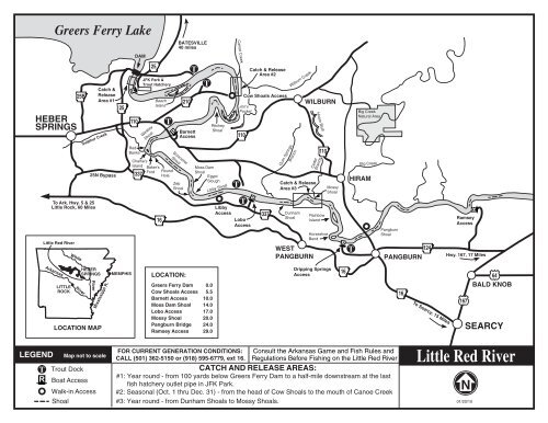
Little Red River Map - Little Rock District
Little Red River Map - Little Rock District
Little Red River Map - Little Rock District

You also want an ePaper? Increase the reach of your titles
YUMPU automatically turns print PDFs into web optimized ePapers that Google loves.
<strong>River</strong><br />
R<br />
Greers Ferry Lake<br />
HEBER<br />
SPRINGS<br />
Sulphur Creek<br />
To Ark. Hwy. 5 & 25<br />
<strong>Little</strong> <strong>Rock</strong>, 60 Miles<br />
<strong>Little</strong> <strong>Red</strong> <strong>River</strong><br />
White<br />
25B<br />
Catch &<br />
Release<br />
Area #1<br />
25N Bypass<br />
25<br />
R<br />
110<br />
DAM<br />
<strong>Red</strong><br />
Banks<br />
Charlie's<br />
Island<br />
337<br />
25<br />
JFK Park &<br />
Trout Hatchery<br />
Winkley<br />
Shoal<br />
Baker's<br />
Ford<br />
Beech<br />
Island<br />
16<br />
T<br />
R<br />
Round<br />
Hole<br />
Scroncher<br />
Shoal<br />
BATESVILLE<br />
40 miles<br />
210<br />
Barnett<br />
Access<br />
Zeb<br />
Shoal<br />
T<br />
T<br />
Moss Dam<br />
Shoal<br />
Ritchey<br />
Shoal<br />
Egypt<br />
Slough<br />
Libby Shoal<br />
Libby<br />
Access<br />
Canoe Creek<br />
T<br />
110<br />
Catch & Release<br />
Area #2<br />
Cow Shoals Access<br />
Jon's<br />
Pocket<br />
T<br />
R<br />
Lobo<br />
Access<br />
337<br />
Wilburn Creek<br />
Gum Springs<br />
Branch<br />
Catch & Release<br />
Area #3<br />
Dunham<br />
Shoal<br />
WILBURN<br />
Cedar<br />
Branch<br />
WEST<br />
PANGBURN<br />
Hiram Bluff<br />
110<br />
Rainbow<br />
Island<br />
Horseshoe<br />
Bend<br />
Mossy<br />
Shoal<br />
R<br />
T<br />
Big Creek<br />
Natural Area<br />
Big Creek<br />
HIRAM<br />
Pangburn<br />
Shoal<br />
124<br />
PANGBURN<br />
Ramsey<br />
Access<br />
Hwy. 167, 17 Miles<br />
Arkansas<br />
LITTLE<br />
ROCK<br />
<strong>River</strong><br />
HEBER<br />
SPRINGS<br />
LOCATION MAP<br />
Mississippi R.<br />
MEMPHIS<br />
LOCATION:<br />
Greers Ferry Dam 0.0<br />
Cow Shoals Access 5.5<br />
Barnett Access 10.0<br />
Moss Dam Shoal 14.0<br />
Lobo Access 17.0<br />
Mossy Shoal 20.0<br />
Pangburn Bridge 24.0<br />
Ramsey Access 29.0<br />
Dripping Springs<br />
Access<br />
16<br />
16<br />
To Searcy, 15 Miles<br />
64<br />
BALD KNOB<br />
167<br />
SEARCY<br />
LEGEND<br />
T<br />
R<br />
<strong>Map</strong> not to scale<br />
Trout Dock<br />
Boat Access<br />
Walk-in Access<br />
Shoal<br />
FOR CURRENT GENERATION CONDITIONS: Consult the Arkansas Game and Fish Rules and<br />
CALL (501) 362-5150 or (918) 595-6779, ext 16. Regulations Before Fishing on the <strong>Little</strong> <strong>Red</strong> <strong>River</strong><br />
CATCH AND RELEASE AREAS:<br />
#1: Year round - from 100 yards below Greers Ferry Dam to a half-mile downstream at the last<br />
fish hatchery outlet pipe in JFK Park.<br />
#2: Seasonal (Oct. 1 thru Dec. 31) - from the head of Cow Shoals to the mouth of Canoe Creek<br />
#3: Year round - from Dunham Shoals to Mossy Shoals.<br />
<strong>Little</strong> <strong>Red</strong> <strong>River</strong><br />
N<br />
01/20/10
Welcome To Greers Ferry Lake<br />
Please Read And Observe The Following Park Rules:<br />
1. VEHICLES – PARK & OPERATE VEHICLES ONLY ON PAVED SURFACES. No parking on launch<br />
ramp or adjacent to swim beach. No ATV's. Campsite parking is for campers only.<br />
2. CAMPING – Campsite occupancy shall not exceed eight persons. Campsite equipment is limited to 4 tents OR<br />
2 tents and 1 wheeled camping unit (not 2 trailers). Check with park attendant before occupying any campsite.<br />
Camping is limited to 14 consecutive days. Checkout time is 4:00 pm. Check in time is 5:00 pm. Discounts<br />
apply only to the site occupied by the passport holder. Maximum of 8 persons per site.<br />
3. FIRES – Only permitted in grills, fireplace, and fire rings provided. Put fire out before leaving. Only fallen<br />
dead wood can be collected for firewood. Do not use fireplace, grills or fire rings for trash. County and state<br />
burn bans apply to all Corps of Engineers Parks.<br />
4. TREES AND VEGETATION – Do not cut, chop, break or alter trees, shrubs or other vegatation. Operation of<br />
vehicles off paved surfaces is prohibited.<br />
5. QUIET HOURS – 10:00 pm until 6:00 am. Violation of quiet hours may result in citation and/or eviction from<br />
the park. All vehicles that enter park after 10:00 pm must display a camping pass to gain entry. Failure to display<br />
camping pass after 10:00 p.m. may result in denial of entry into the campground. All visitors and day use must<br />
exit the park prior to quiet hours (10:00 p.m. - 6:00 am).<br />
6. PETS – Must be on a leash no longer than 6 feet and under control at all times. Running cables/chains are not<br />
permitted. Pets that are deemed to be aggressive, vicious or a nuisance may be required to be removed from the<br />
park. Pets are not allowed in the swim areas.<br />
7. FIREWORKS AND WEAPONS – Possession or use of weapons or fireworks is prohibited.<br />
8. TRASH – Trash cans are no longer provided at campsites. Please place trash in dumpsters located near the park<br />
entrance. Do not leave trash at campsite. Disposal of gray water, sewage, household or business trash on project<br />
grounds, in project waters or in trash dumpsters is prohibited.<br />
9. DAY USE AREA– (Swim Beach/Picnic Areas) – Gates open at 9:00 a.m. and area closes at 9:00 p.m.<br />
Do not park on campsites unless camping on the site. Check with park attendants before occupying any campsite.<br />
10. SWIM AREA – No pets in designated swim areas. No lifeguards, swim at your own risk. Swim areas closed<br />
from 10:00 p.m. until 6:00 a.m. No glass containers. Boats are prohibited in swim areas.<br />
Dam Site Day Use Area--see #9 above.<br />
11. For a complete listing of all park regulations, obtain a copy of Title 36, Part 327, Code of Federal Regulations, at<br />
the park entrance or the Project Office. Violation of park regulations may result in citation and/or expulsion from<br />
project lands.<br />
RESERVATIONS: Individual Campsites can be reserved up to 6 months in advance but must be made<br />
at least 4 days prior to arrival. To make a reservation call 1-877-444-6777 or<br />
online at www.recreation.gov.<br />
Wear Your Life Jacket; It’s Your Friend for Life! For more water safety information, visit<br />
our website at: http://www.SWL.usace.army.mil/watersafety<br />
Greers Ferry Project Office<br />
P.O. Box 1088<br />
Heber Springs, Arkansas 72543<br />
(501) 362-2416<br />
Mon - Fri, 7:30 am until 4:00 pm (except holidays)<br />
www.SWL.usace.army.mil/parks/greersferry<br />
01/01/10