

Watershed Management - Southwest Florida Water Management ...
Watershed Management - Southwest Florida Water Management ...
Watershed Management - Southwest Florida Water Management ...

Create successful ePaper yourself
Turn your PDF publications into a flip-book with our unique Google optimized e-Paper software.
<strong>Southwest</strong> <strong>Florida</strong> <strong>Water</strong> <strong>Management</strong> District<br />
What Is a <strong><strong>Water</strong>shed</strong><br />
<strong>Management</strong> Approach?<br />
A watershed management approach is one that<br />
considers the watershed as a whole, rather than<br />
separate parts of the watershed in isolation.<br />
Managing the water and other natural resources<br />
is an effective and efficient way to sustain the local<br />
economy and environmental health. Scientists<br />
and leaders now recognize the best way to protect<br />
the vital natural resources is to understand and<br />
manage them on a watershed basis.<br />
Almost every activity on the land has the<br />
potential to affect the quality and quantity of<br />
water in our waterways. <strong><strong>Water</strong>shed</strong> management<br />
helps reduce flood damage, decrease the loss of<br />
green space, reduce soil erosion and improve<br />
water quality. <strong><strong>Water</strong>shed</strong> planning brings<br />
together the people within the watershed,<br />
regardless of political boundaries, to address a<br />
wide array of resource management issues.<br />
At the heart of watershed management is the<br />
underlying philosophy that “everything is<br />
connected to everything else.” Like the<br />
links of a chain or the spokes of a wheel,<br />
watershed components are<br />
interconnected and mutually<br />
supporting. The health of upstream<br />
components directly determines the<br />
health and function of areas<br />
downstream. Our actions affect our<br />
neighbors as well as neighboring communities.<br />
higher<br />
Land Surface Elevation<br />
lower<br />
Coast<br />
<strong><strong>Water</strong>shed</strong>s in West-Central <strong>Florida</strong><br />
The <strong>Southwest</strong> <strong>Florida</strong> <strong>Water</strong> <strong>Management</strong> District, also referred<br />
to as the District, encompasses 10,000 square miles within<br />
16 counties in west-central <strong>Florida</strong>. This includes 13 major<br />
rivers, 1,800 lakes that are 10 or more acres in size, 3 major<br />
estuaries, 1.1 million acres of wetlands, 3 aquifers and numerous<br />
smaller rivers, creeks and streams. Within the boundaries of the<br />
District, there are approximately 250 recognized watersheds that<br />
have been consolidated into 11 primary watersheds.<br />
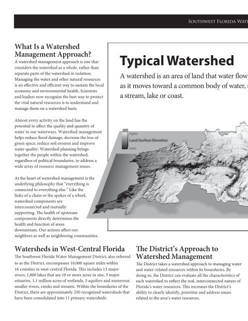
Typical <strong><strong>Water</strong>shed</strong><br />
A watershed is an area of land that water flows across<br />
as it moves toward a common body of water, such as<br />
a stream, lake or coast.<br />
Lowlands<br />
River or Stream<br />
The District’s Approach to<br />
<strong><strong>Water</strong>shed</strong> <strong>Management</strong><br />
The District takes a watershed approach to managing water<br />
and water-related resources within its boundaries. By<br />
doing so, the District can evaluate all the characteristics of<br />
each watershed to reflect the real, interconnected nature of<br />
<strong>Florida</strong>’s water resources. This increases the District’s<br />
ability to clearly identify, prioritize and address issues<br />
related to the area’s water resources.<br />
Uplands<br />
Uplands<br />
Major <strong><strong>Water</strong>shed</strong>s<br />
1<br />
2<br />
3<br />
4<br />
5<br />
6<br />
7<br />
8<br />
9<br />
10<br />
11<br />
Withlacoochee River<br />
Springs Coast<br />
Tampa Bay/Anclote River<br />
Hillsborough River<br />
Alafia River<br />
Little Manatee River<br />
Manatee River<br />
Southern Coastal<br />
Myakka River<br />
Peace River<br />
Lake Wales Ridge<br />
Uplands<br />
Uplands<br />
Successful watershed management needs the involvement<br />
and cooperation of all stakeholders within a watershed. A<br />
stakeholder is anyone who has a share or interest in any or<br />
all issues related to our watersheds. Examples of<br />
stakeholders include the District, local governments,<br />
residents, industries and agricultural organizations. By<br />
including many interest groups, local watershed<br />
partnerships tap the varied perspectives of different partners,<br />
increase credibility, reduce duplication of effort and<br />
maximize results from limited funds.<br />
3<br />
2<br />
8<br />
7<br />
6<br />
4<br />
1<br />
9<br />
5<br />
10<br />
11<br />
Comprehensive <strong><strong>Water</strong>shed</strong><br />
<strong>Management</strong> Initiative<br />
In 1994, as part of its watershed<br />
management approach, the District<br />
established the Comprehensive<br />
<strong><strong>Water</strong>shed</strong> <strong>Management</strong> (CWM,<br />
pronounced “sea-whim”) initiative.<br />
Under this initiative, the District<br />
developed CWM teams for each of<br />
the 11 primary watersheds within its<br />
jurisdiction: Withlacoochee River,<br />
Springs Coast, Tampa Bay/Anclote<br />
River, Hillsborough River, Alafia<br />
River, Little Manatee River,<br />
Manatee River, Southern Coastal,<br />
Myakka River, Peace River and Lake<br />
Wales Ridge.<br />
The CWM teams determined the<br />
issues regarding watershed health,<br />
established goals for protection and<br />
enhancement, and then developed<br />
strategies to achieve those goals. The<br />
teams included representatives from<br />
local governments, interested<br />
organizations and citizens, and<br />
District staff. These teams submitted<br />
their findings to the District in<br />
CWM plans.<br />
<strong><strong>Water</strong>shed</strong> <strong>Management</strong><br />
Program<br />
Based on the CWM plans, the<br />
District has developed a <strong><strong>Water</strong>shed</strong><br />
<strong>Management</strong> Program (WMP).<br />
This program identifies ways to effectively coordinate and<br />
implement CWM strategies. The WMP has five elements:<br />
1. Topographic Information<br />
Determining the surface features and understanding the<br />
boundaries of each watershed is essential to developing the<br />
elements of the WMP. Digital topographic maps, aerial<br />
photographs and ground survey controls are generated<br />
during this process. This information provides the<br />
foundation for the other elements of the WMP.


