Alafia River Minimum Flows and Levels - Southwest Florida Water ...
Alafia River Minimum Flows and Levels - Southwest Florida Water ... Alafia River Minimum Flows and Levels - Southwest Florida Water ...
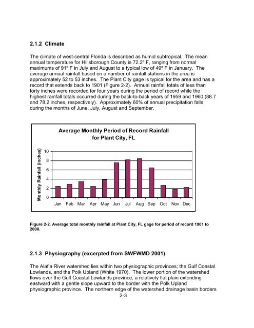
2.1.2 Climate The climate of west-central Florida is described as humid subtropical. The mean annual temperature for Hillsborough County is 72.2º F, ranging from normal maximums of 91º F in July and August to a typical low of 49º F in January. The average annual rainfall based on a number of rainfall stations in the area is approximately 52 to 53 inches. The Plant City gage is typical for the area and has a record that extends back to 1901 (Figure 2-2). Annual rainfall totals of less than forty inches were recorded for four years during the period of record while the highest rainfall totals occurred during the back-to-back years of 1959 and 1960 (88.7 and 78.2 inches, respectively). Approximately 60% of annual precipitation falls during the months of June, July, August and September. Average Monthly Period of Record Rainfall for Plant City, FL Monthly Rainfall (inches) 10 8 6 4 2 0 Jan Feb Mar Apr May Jun Jul Aug Sep Oct Nov Dec Figure 2-2. Average total monthly rainfall at Plant City, FL gage for period of record 1901 to 2000. 2.1.3 Physiography (excerpted from SWFWMD 2001) The Alafia River watershed lies within two physiographic provinces; the Gulf Coastal Lowlands, and the Polk Upland (White 1970). The lower portion of the watershed flows over the Gulf Coastal Lowlands province, a relatively flat plain extending eastward with a gentle slope upward to the border with the Polk Upland physiographic province. The northern edge of the watershed drainage basin borders 2-3
an adjacent area locally known as the Brandon Karst Terrain (BKT), an internally drained basin (SWFWMD 1993). The western edge of the Polk Upland is defined by the presence of the first of several paleo-shoreline scarps associated with the Pleistocene Ice-Age sea level fluctuations. This physiographic feature is known as the Pamlico Scarp or shoreline. Elevations in this part of the Gulf Coast lowlands province range from sea level to 25 feet. The rest of the Alafia River watershed is situated in the Polk Upland Province. Elevations in the extensive Polk Upland range between 100 and 130 feet; however, in this area of the province the elevations are mostly between 25 and 75 feet within the watershed. Eastward of the Pamlico Scarp the river's banks attain a narrower, steeper profile and some spots are very bluff-like with 20-25 feet of relief from the river's water level. In the vicinity of Riverview and Bell Shoals, the physiography adjacent and south of the river is composed of low sand hills, which in some cases attain 75-80 feet elevation. The Talbot and Penholoway paleo-shorelines pass through this area in a north-south orientation, with their surface features having elevations of 42 and 75 feet, respectively. Moving eastward, further into the Polk Upland province, in the vicinity of the town of Lithia, the river travels over the clayrich Bone Valley Formation (Pliocene). This is the lithologic unit which is extensively mined for phosphate minerals further into the eastern part of the Alafia River watershed. The river's banks in this region become less steep with many low-relief floodplain or wetland areas surrounding the river. The remainder of the Alafia River watershed and its tributaries drain an area of the Polk Upland where the Pleistocene marine sands (overburden), and the underlying materials of the ore-bearing Bone Valley Formation and Hawthorn Group rocks have been disturbed for phosphate strip-mining in many areas. Much of this area has had its physiography and associated surface water drainage systems modified by this mining activity. This process generally strips the overburden sediments out of the way, mines the ore layer, and then redistributes the overburden sediments through land reclamation or other processes. Outstanding physiographic features in this region include many water-filled, former mine pits and large, bermed clay-settling areas of various rectilinear configurations easily observable on maps and aerials photos. Most all the areas identified as "Open Water" natural systems in the entire eastern half of the basin south of State Road 60 are of phosphate mining origin. Primary soil groups in the Alafia River watershed include the Myakka-Basinger- Holopaw association, which predominates in the upland areas in the northern and southern portions of the watershed. The Candler-Lake association occurs in the vicinity of the Brandon-Bloomingdale area, while the Winder-Chobee-St. Johns occurs along the main stem of the river including the main tributaries. A significant area of Arents-Haplaquents-Quartzipsamments soils occupies an area surrounding Durant, in the Turkey Creek drainage basin. Soil classification indicates these are considered as manmade soil areas. This area extends from southern Dover through the Medard Park/Reservoir and Lithia area, and to some minor areas on the east side of State Road 39. This coincides with areas of former phosphate mining 2-4
- Page 1 and 2: Alafia River Minimum Flows and Leve
- Page 3 and 4: Table of Contents Table of Contents
- Page 5 and 6: 4.3.1 HEC-RAS Modeling ............
- Page 7 and 8: Table of Figures Figure 1-1. Buildi
- Page 9 and 10: Figure 2-33. Phosphorus concentrati
- Page 11 and 12: Figure 5-12. Habitat Gain/Loss for
- Page 13 and 14: Table 5-2. Mean elevation, local (c
- Page 15 and 16: flow, with the exception that withd
- Page 17 and 18: Acknowledgement The authors would l
- Page 19 and 20: 9) Water quality; and 10) Navigatio
- Page 21 and 22: Water Management District typically
- Page 23 and 24: Peace River at Zolfo Springs, FL. s
- Page 25 and 26: Period of Record Median Daily Flows
- Page 27 and 28: to enhance understanding of histori
- Page 29: River watershed, to the east by the
- Page 33 and 34: Water in the surficial aquifer is r
- Page 35 and 36: The Upper Floridan aquifer (UFA) sy
- Page 37 and 38: Figure 2-4. May and September 2001
- Page 39 and 40: head differences indicating breache
- Page 41 and 42: data (multiple regression) analyses
- Page 43 and 44: 2.2 Land Use Changes in the Alafia
- Page 45 and 46: Before discussing individual sub-ba
- Page 47 and 48: Table 2-2. Land use and land cover
- Page 49 and 50: Table 2-3. Land use and land cover
- Page 51 and 52: Figure 2-13. 1972 and 1999 Land use
- Page 53 and 54: 2.2.4 Lithia Springs Sub-Basin The
- Page 55 and 56: 2.3 Hydrology The assessment of min
- Page 57 and 58: Period of Record Median Daily Flows
- Page 59 and 60: occurred during the spring were sim
- Page 61 and 62: Conversely, since most of the Unite
- Page 63 and 64: extending from 1940 to 1969 can be
- Page 65 and 66: Period of Record Median Daily Flows
- Page 67 and 68: third highest flow occurred early i
- Page 69 and 70: Flow (cfs) Alafia River at Lithia,
- Page 71 and 72: 100 North Prong Alafia River at Key
- Page 73 and 74: Flow (cfs) South Prong Alafia River
- Page 75 and 76: Alafia River at Lithia - Water Qual
- Page 77 and 78: South Prong Watershed Above USGS Ga
- Page 79 and 80: Comparisons of land use changes and
2.1.2 Climate<br />
The climate of west-central <strong>Florida</strong> is described as humid subtropical. The mean<br />
annual temperature for Hillsborough County is 72.2º F, ranging from normal<br />
maximums of 91º F in July <strong>and</strong> August to a typical low of 49º F in January. The<br />
average annual rainfall based on a number of rainfall stations in the area is<br />
approximately 52 to 53 inches. The Plant City gage is typical for the area <strong>and</strong> has a<br />
record that extends back to 1901 (Figure 2-2). Annual rainfall totals of less than<br />
forty inches were recorded for four years during the period of record while the<br />
highest rainfall totals occurred during the back-to-back years of 1959 <strong>and</strong> 1960 (88.7<br />
<strong>and</strong> 78.2 inches, respectively). Approximately 60% of annual precipitation falls<br />
during the months of June, July, August <strong>and</strong> September.<br />
Average Monthly Period of Record Rainfall<br />
for Plant City, FL<br />
Monthly Rainfall (inches)<br />
10<br />
8<br />
6<br />
4<br />
2<br />
0<br />
Jan Feb Mar Apr May Jun Jul Aug Sep Oct Nov Dec<br />
Figure 2-2. Average total monthly rainfall at Plant City, FL gage for period of record 1901 to<br />
2000.<br />
2.1.3 Physiography (excerpted from SWFWMD 2001)<br />
The <strong>Alafia</strong> <strong>River</strong> watershed lies within two physiographic provinces; the Gulf Coastal<br />
Lowl<strong>and</strong>s, <strong>and</strong> the Polk Upl<strong>and</strong> (White 1970). The lower portion of the watershed<br />
flows over the Gulf Coastal Lowl<strong>and</strong>s province, a relatively flat plain extending<br />
eastward with a gentle slope upward to the border with the Polk Upl<strong>and</strong><br />
physiographic province. The northern edge of the watershed drainage basin borders<br />
2-3


